Abstract
Surface water flooding poses significant threats to communities and environments. This threat has historically been managed through sewers and combined sewer overflows; however, it is now well recognised that, alone, these legacy systems are insufficient to manage the growing pressures from climate change, population growth and urbanisation. This realisation has led to research and practice developing a broad range of new technologies to enhance the coping capacities of existing sewer systems through capturing and attenuating or reusing surface water across catchments using sustainable drainage systems (SuDS). However, despite technical understanding, industry champions and significant best practice, SuDS remain underutilised, particularly at a synergistic catchment scale where they can be most effective. In this paper we respond to this challenge by developing preliminary screening tools to enhance the visibility of SuDS among the multidisciplinary decision-makers responsible for directing strategic surface water management. We achieve this through upscaling a regional decision support model and demonstrating implementation across a case study in South West England. We find that it is possible to use easily accessible and open-source data to provide initial indications of SuDS opportunities and that this early visibility in the decision-making process can be used to support the consideration of novel and effective surface water management strategies.
1. Introduction
Surface water flooding is a significant threat to lives, homes and infrastructure across many global contexts. Surface water flooding already causes billions in annual damages; however, it is now well understood that the threat is likely to worsen in line with increasing precipitation intensities triggered by climate change, deterioration of ageing and expensive subterranean infrastructure and increasing runoff from urbanisation [1,2,3,4,5,6].
In response, research and practice have developed a range of technical solutions, which capture, store, regulate and reuse surface water, thus reducing runoff and alleviating pressure on downstream infrastructure. These solutions are referred to under a range of synonyms including, but not limited to, sustainable drainage systems (SuDS), water sensitive urban design, sponge cities, best management practices, nature-based solutions, blue-green systems and low impact development measures, among others [7,8,9,10,11,12]. For this paper we will adopt the term ‘SuDS’, reflecting common practice in our case study location of the United Kingdom [13,14,15,16].
SuDS and similar interventions have been instrumental in managing runoff at site scales in both new urban developments [17] and retrofitting to existing buildings [18]. Consequently, technical understanding, practical design and building experience regarding application at an individual property, small site or suburb scale are well developed [12,13,15,19]. However, despite this wealth of interventions supported by established guidance and legislation, which has been in force decades [11,20,21,22,23,24,25], it remains apparent that current implementation of SuDS has not transcended site-based application towards the city or regional scale required to manage future threats [26,27,28,29,30]. In the cases where wider scale application is observed, measures still tend to focus on a small subset of available options rather than considering synergistic deployment across multiple options, locations and actors [12,14].
This inertia is apparent at a global scale, with many reviews citing a range of barriers to the implementation of SuDS [11,21,27,31,32]. In particular, research highlights a failure to accommodate SuDS within accessible decision-making frameworks, uncertainty regarding the selection of novel interventions in a risk-averse industry and a lack of evidence regarding the integration of strategies and stakeholders at the catchment and landscape scale [31,33,34,35,36,37,38].
Studies have also demonstrated that, where SuDS are implemented, not all locations are equal and that the same SuDS positioned in different locations across a catchment can demonstrate a wide range of performance and cost-effectiveness [39]. Similarly, research demonstrates that synergistic effects of interventions where larger catchments are strategically and systematically managed can compound towards much more effective strategies than individual measures alone [14]. Consequently, current SuDS policies, which typically do not develop strategies at a regional scale, can lead to ad hoc and opportunistic implementation of interventions [28], resulting in suboptimal performance [30], missing potential synergies to realise multiple benefits [25,36,40] and uneven accrual of benefits across populations and communities [41,42].
Systematic regional implementation of SuDS requires alignment of many multidisciplinary actors, including, but not limited to, architects, planners, engineers, environmentalists, utility providers, governance and communities [25]. However, this collaborative approach is not always adopted [27,32,43]. Therefore, new tools that facilitate knowledge transfer of regional perspectives at the outset of design and communicate effectively across the diverse range of regional stakeholders are crucial for coordinating sustainable, social, environmental and economical regional policies [12,28].
This paper addresses the challenges of realising and integrating potential benefits across actors at this regional scale through enhancing the tools and evidence available for planning authorities to evaluate SuDS opportunities and coordinate application across locations and stakeholders. Our work has two key aims. The first is to increase consideration and application of SuDS in the informative early stages of decision support/design scoping (with hopes that this consideration will develop towards later detailed design and implementation). The second is to develop outputs that are accessible to a range of disciplines and levels of experience, therefore increasing the visibility, viability and coordination of sustainable drainage management at the much-needed regional scale. We achieve this through significantly upscaling an existing urban-scale planning support system to a novel regional outlook, advancing a city-scale model through to a much larger analytical scope. We demonstrate and explore our approach through developing regional analysis in South West England and evaluating the opportunities and limitations of this novel screening method.
2. Methods
2.1. Upscaling a Planning Support System to Achieve Regional Screening
We adapted an existing city-scale planning support system, the Spatial Suitability Analysis Tool (SSANTO), up to a regional-scale analysis of opportunities and needs for SuDS [44]. This tool performs a fast, robust and spatially explicit geospatial multicriteria decision analysis of SuDS suitability through evaluating a range of landscape, biophysical, socioeconomic and planning criteria. The tool achieves this through spatial analysis of each criterion and then develops a suitability score for each SuDS type based on a value from 0 (not applicable) to 100 (highly suitable). A significant benefit of this approach is the ready-to-use and intuitive outputs, which are easily interpreted by both experts and laypeople alike.
SSANTO explores SuDS suitability through identifying ‘opportunities’ and ‘needs’ for SuDS implementation [45]. Opportunities represent locations that have a high suitability for SuDS measures to be implemented due to favourable (bio)physical and societal characteristics. Needs represent locations where the benefits of SuDS fulfil valuable ecosystem service requirements including provisioning, regulating, cultural and habitat. Our analysis outputs suitability maps of both types for SuDS types across Devon, a county in South West England. Both are scored from 0 to 100, with 0 being unsuitable and 100 being highly suitable. These scores are calculated using separate geographic information system (GIS) multiple-criteria decision analysis (MCDA) exercises, each using different criteria (Table 1). A full description of SSANTO’s methodology and development of weightings for the GIS-MCDA is available in the work of Kuller et al. (2019) [44].

Table 1.
Data types applied in this study, specified per SuDS type. RG: rain gardens and bioretention systems, IS: infiltration system, GR: green roofs, PL: ponds and lakes, SW: swales, RT: rain tanks, CW: constructed wetlands.
As with the majority of spatial SuDS suitability analyses, the previous application of SSANTO has been limited to the city or urban subcatchment scale. Our study implementing a regional- and landscape-scale SuDS screening is a novel expansion of this established methodology, taking a proven planning support tool and adapting it in response to a research need for integrated regional planning.
We discuss specific criteria, scale and data sources required for our regional analysis in subsequent sections of our paper. However, note that full detail of the validation, explanation of MCDA scoring for each criterion and development of SSANTO is already published and available in the work of Kuller et al. (2019) [44].
2.2. Applying Decision Criteria and Data Types Available at the Outset of Strategic Design
Our study is aimed at supporting stakeholders during the preliminary stages of regional-scale strategic design; therefore, it was imperative that we used easily accessible, open access and regionally consistent spatial data that are likely to be available across a range of contexts.
We performed our analysis for a variety of SuDS types including bioretention systems/rain gardens, infiltration systems, green roofs, rain tanks, swales, ponds and lakes and constructed wetlands. Each SuDS measure was assessed through MCDA of up to 14 decision variables (criteria), which were all represented in a spatially explicit manner: land cover, slope, building footprints, surface water, distance to waterways, distance to airports, street width/type, land value, irrigation demand, sports fields, green cover and recreation sites. A full description of these data is available in Table 1.
2.3. Devon Case Study
We trialled our expansion of SSANTO through application across a regional case study of Devon, United Kingdom. Devon is a county located in the South West of the UK. It is one of the largest counties in England, covering over 6500 km2; however, it is relatively sparsely populated, with a population of c. 1.1 million. Land use is mixed, with a predominantly rural setting, national parks and several large towns, notably including Exeter and Plymouth. This mixed land use provides a great opportunity to investigate a range of conditions, contexts and SuDS types [12]. This mixed landscape provides an excellent exemplar for upscaling previous urban-centric SuDS modelling towards a regional focus and develops findings that are transferable across other contexts.
Devon is of particular significance for UK surface water management for three key reasons: Firstly, Devon is a popular holiday destination with a large number of recreational waters; however, these are currently highly susceptible to contamination through the combined sewer systems which predominantly serve the region, which in recent years have discharged to the water environment significantly more than intended [46]. Secondly, Devon has several steep valley catchments, which respond rapidly to heavy rainfall. This has led to several major surface water flood events, including the 1952 Lynmouth flood in which 34 people lost their lives [47,48]. Thirdly, the cities of Exeter and Plymouth are experiencing considerable population growth and urbanisation, resulting in not only higher potential surface water risks but also new opportunities for integrating SuDS in strategic design.
We also selected this area for our case study due to an established regional research partnership (The South West Partnership for Environmental and Economic Prosperity: ‘SWEEP’), which consists of an established network of academic, industry, public and governance stakeholders who support, engage and deploy novel research pertaining to South West England [49].
2.4. Open Access Data Sources Used for Analysis
A significant limiting factor in consideration and deployment of novel surface water management technologies is their lack of inclusion within institutional decision-making frameworks, compounded by the unavailability of evidence and data on which to base decisions at an early enough stage to be informative and influential in strategic decision support [11,31]. Therefore, we based our analysis on data types that are readily available, transferable and informative in the early stages of design. At times, the need to provide accessible data applicable across the scale of the study area conflicts with the level of detail required for full decision support. This makes our approach best suited to an early engagement of possible interventions, with outcomes seeking to evidence and direct subsequent stages of data collection, modelling and implementation.
Table 1 presents the data sources applied for this study. The table outlines the criteria, the SuDS measures they inform and the data input into SSANTO to measure them. We used all criteria in our analysis; however, depending on the system type, the criteria and value scales change. Relevant criteria for each system type and respective value scales are detailed further in Kuller et al. (2019) [44], and full parameters for our study are presented in our supplementary information.
We included land cover using the Centre for Ecology and Hydrology Land Cover Map 2019 [50], which delimited the full study area into 21 land cover categories and transformed these categories into suitability scores for the seven SuDS measures evaluated in our study. Full details are available in the work of Kuller et al. (2019) and our supplementary information [44].
Slope is applied as a suitability factor for SuDS measures, with high slopes indicating low suitability for many SuDS types. We calculated slope through processing a 50 m resolution digital elevation model using the ArcGIS slope calculation spatial analysis function [51]. We selected the 50 m resolution product due to complete coverage of our expansive study area, efficiency of the computational process and availability of analogous data across the rest of the UK and comparable international contexts.
Building footprints are used to indicate suitability for the application of green roof and rain tank interventions, whilst acting as a mask to exclude other interventions. We represented footprints using the aggregated building polygons provided by the open-source Ordnance Survey ‘Open Zoomstack’ product [52]. As with other data types used in this study, this product has full national coverage, representing the extent of built structures and aggregated to a computationally efficient resource. In this case, aggregation means building outlines are grouped into adjacent structures; for example, a row of terraced housing is represented as one polygon, rather than individual polygons for individual properties. This format is ideal for regional-scale analysis.
Surface water is used as a mask to exclude SuDS placement. We gathered surface water layers from the Ordnance Survey Zoomstack product [52]. Distance to surface water is applied as a suitability criterion for certain SuDS options; we calculated this through GIS buffers. We included airports using the same methodology, with certain SuDS (for example wetlands and ponds) being unsuitable in close proximity to these features due to issues with wetland bird populations creating risks during takeoff and landing.
Street classification is used to evaluate the suitability of options. We gathered street types from the OS Open Roads data set [53] and included motorways, A, B, Minor, Local and Access roads within our classification
Land value impacts suitability through the need to acquire land for SuDS implementation. High land value makes land acquisition for systems with a large footprint (e.g., constructed wetlands) expensive and thus reduces suitability. We used the land cover map to identify land types [50] and the UK Government land value estimates for policy appraisal to identify the cost of land [54]. We used Exeter, as the regional capital of Devon, as the basis for our estimates and differentiated values on a price per ha of urban, suburban and other land uses.
Distance to irrigation demand is used to prioritise SuDS capable of alleviating local water resource pressures. We identified irrigation demand to include allotments; outdoor sports facilities; public parks; and other recreational, ceremonial or municipal spaces, and we extracted these from open mapping products [52]. We used a similar approach to identify sports fields, recreation facilities and public green spaces.
We calculated imperviousness for three broad land use categories based on percentage imperviousness from literature [10] and with locations defined using land cover mapping [50].
We also included data on areas exposed to medium-sized floods. We selected medium-sized floods as these are the areas that are most likely to benefit from SuDS for flood mitigation [30,55]; low-magnitude, high-frequency floods are usually managed by urban drainage systems, and high-magnitude, low-frequency ‘extreme’ flood events are typically managed using large engineered interventions [10]. We included medium-sized floods by extracting the so-called “flood zone 2” areas from the UK Environment Agency flood mapping; these areas receive a higher suitability score on the needs side [55].
3. Results
In this section, we present selected results from our needs and opportunity mapping, contrasting the needs and opportunities for a range of SuDS. Comparing the needs and opportunity mapping for a system type answers two simple questions of a spatial planner: “Where do we need SuDS?” and “Where can we place SuDS?”.
Our analysis includes a selection of SuDS, providing a range of different measures representative of large-scale regional implementation (i.e., constructed wetlands), measures more suited to site-scale application (i.e., bioretention and rain gardens) and interventions applicable across both site-scale and regional contexts (swales). This range of measures can be used to identify commonalities in types of measures and distributions across the mixed urban–rural landscape found in our study area, with key findings transferable across a range of similar contexts. Full opportunity and needs mappings from all seven measures are available in our supplementary information.
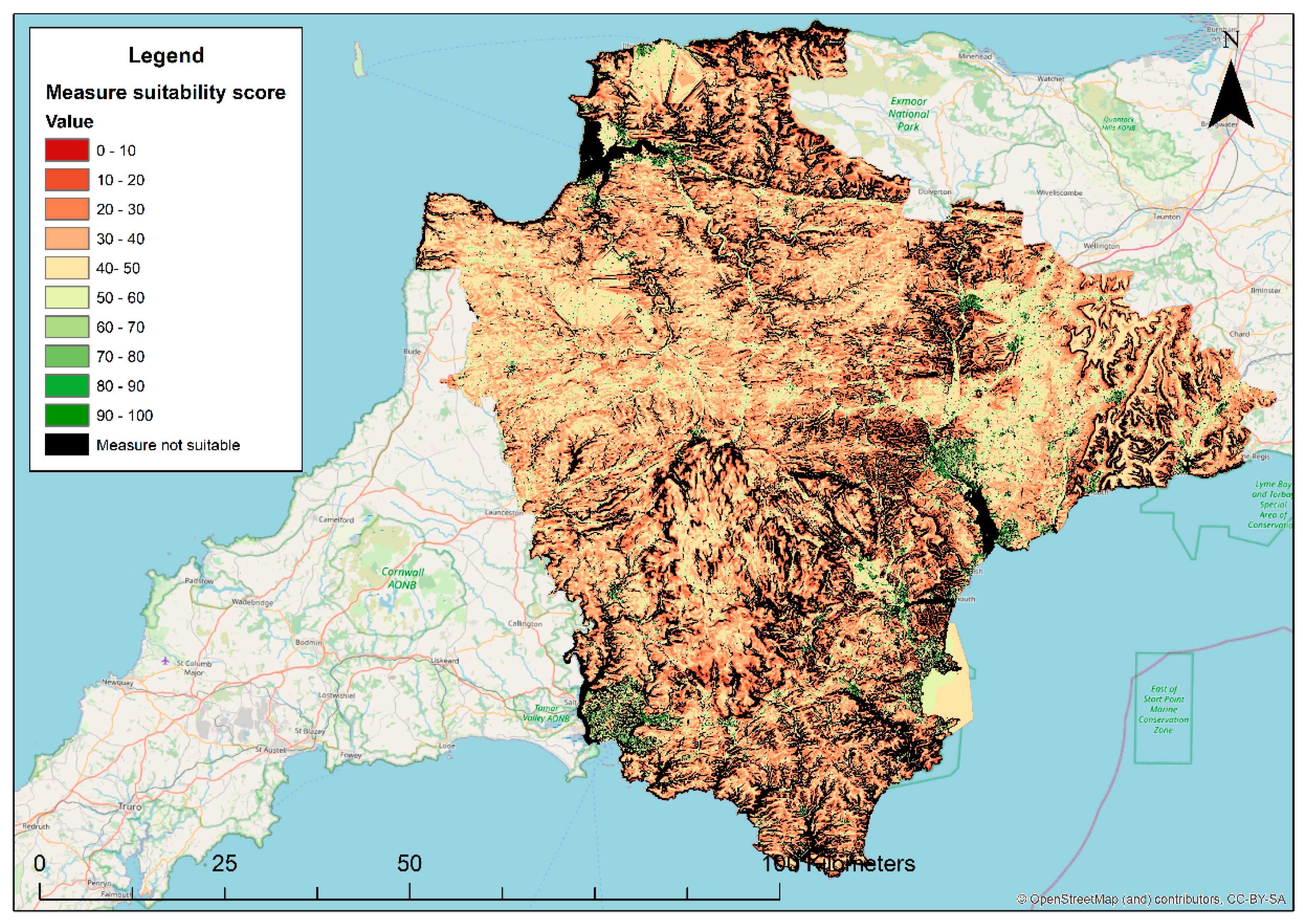
We examine regional-scale SuDS through evaluating constructed wetlands, indicative of a possible landscape management solution for surface water issues which we would expect to be suitable across rural areas of our mixed land cover study area. Figure 1 presents a needs map, identifying areas likely to benefit from implementing constructed wetlands in Devon. Green indicates high needs, red indicates low needs and black indicates that a particular location is unsuitable. The map identifies that the majority of the study area would likely benefit from constructed wetlands, with rural areas exhibiting particularly high benefits.
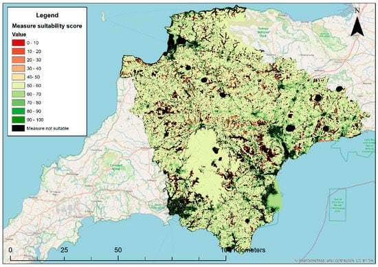
Figure 1.
Needs map showing requirement for the benefits of constructed wetlands in Devon.
Figure 2 shows an opportunity map, highlighting potential locations for constructed wetlands in Devon. This intervention strategy can also be considered indicative of holding water upstream through catchment management approaches, a growing area of research in the area, with particular pertinence to peatland restoration in Dartmoor and Exmoor [56]. These measures are highly suitable in upland regions and flood plains, particularly around the national parks. Wetlands are less suitable in urban areas where space is at a premium, on steep hillsides or within close proximity to airfields where issues with bird strikes during takeoff and landing are prohibitive to implementation.
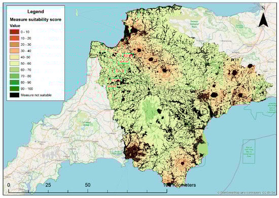
Figure 2.
Opportunity map showing potential locations for constructed wetlands in Devon, indicative of upstream catchment management.
Comparison of Figure 1 and Figure 2 highlights that many areas that would benefit from SuDS are suitable for implementing them. This is particularly evident for upstream and rural locations across the county, supporting further analysis to investigate strategic catchment management approaches such as constructed wetlands across the region. However, there is also an evident disconnect between needs and opportunities across certain areas, with urban regions, steep-sloped catchments and areas near airfields all being unsuitable for implementation.
We evaluate urban scale systems by examining the needs and opportunities for bioretention and rain gardens. These measures are more suited to a smaller scale implementation and so are representative of the sort of approaches that may be more suitable across urban regions. Figure 3 presents areas likely to benefit from the installation of these measures. This indicates that most of the study area would benefit from the installation of these measures, the exception being areas adjacent to coastlines and water bodies, where the benefit is likely to be negligible or measures are unsuitable.

Figure 3.
Needs map showing requirement for the benefits of bioretention and rain gardens in Devon.
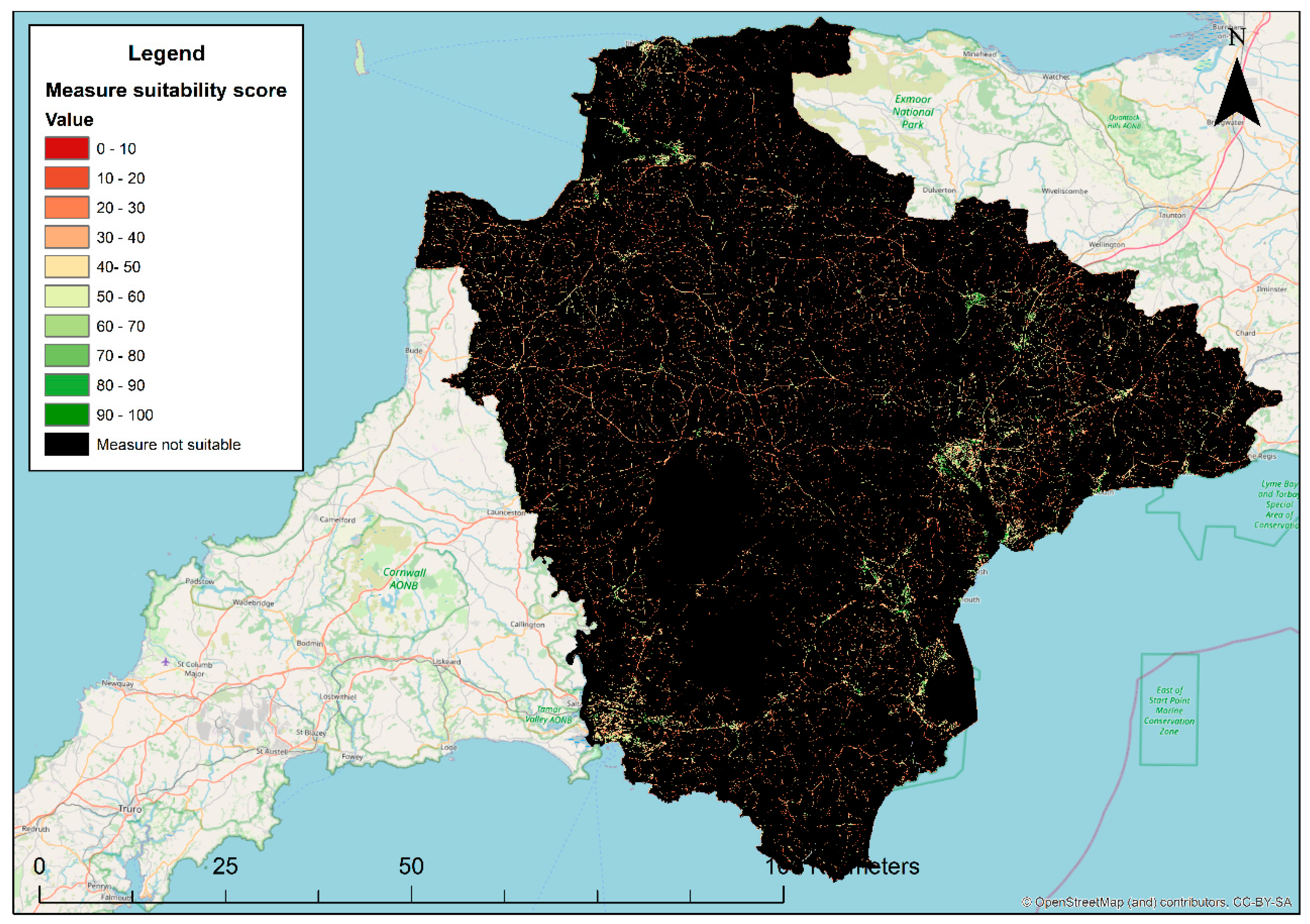
Figure 4 presents potential locations suitable for bioretention and rain gardens. At first glance, it appears that there is low suitability for potential application across the study area. This is due to the upland catchments, steep hillsides and agricultural land dominating the upper catchments. However, urban areas, notably including the towns of Exeter, Plymouth, Torbay and Barnstaple, all exhibit high suitability for these interventions across green spaces. Comparison of Figure 3 and Figure 4 therefore implies that targeting urban green spaces for implementing bioretention and rain gardens is likely to be a feasible and beneficial strategy for managing urban surface water runoff.
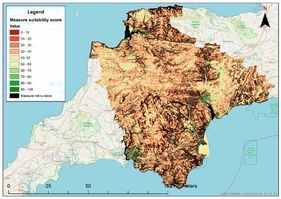
Figure 4.
Opportunity map showing potential locations for bioretention and rain gardens in Devon.
We also evaluated swales to represent an intervention that can easily be implemented across both regional and urban scales. We recognise that swales can be implemented across a variety of contexts [15]; however, for the purposes of this analysis, swales are defined as linear capture, attenuation and conveyance features that manage runoff from roadways and tracks. Due to this definition, large proportions of the catchment that are located away from roads are considered unsuitable for swales. Figure 5 presents locations likely to benefit from deploying swales. This indicates that the majority of areas for which swales are suitable are likely to benefit from their installation. Comparison versus potential sites for constructing swales (Figure 6) indicates these interventions are well suited to minor roads across the study area but are less suitable on verges of faster carriageways where safe vehicle run-off space is a significant design consideration. Swales appear particularly suitable across urban areas, where they can work efficiently as part of SuDS trains, alongside complementary interventions such as designing for exceedance flow routes [57].
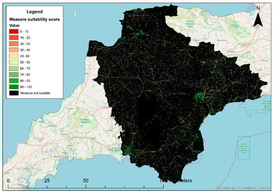
Figure 5.
Needs map showing requirement for the benefits of swales in Devon.
Figure 6.
Opportunity map showing potential locations for swales in Devon.
4. Discussion
4.1. What Does Our Approach Tell Us about the Potential for SuDS in Devon?
The main purpose of our case study is to serve as an exemplar to highlight the sorts of analysis possible using upscaled regional toolsets. Relative to this study, we highlight widespread, systematic and varied needs and opportunities for managing surface water using SuDS and similar distributed surface water management interventions across the full extent of Devon. Figure 1, Figure 3 and Figure 5 exemplify a strong need for SuDS across the study area, with most areas in Devon scoring between 60 and 100 on at least one of the system types on the needs side of suitability. This is in strong support of government guidance, academic research and practical experience advocating stormwater management using these technologies.
It is noteworthy that the needs are higher than opportunities across all the systems we evaluated. This not only supports the development of regional SuDS strategies but also highlights that a diverse range of SuDS types, applicable across many different contexts, should be considered when designing these strategies. Analysis of opportunities highlights that consistent deployment of SuDS at a regional scale is possible through developing interventions complementary to the location and pressures of context, evident through the widespread and complementary distribution of the SuDS measures presented in Figure 2, Figure 4 and Figure 6. This supports the feasibility and potential of synergistic regional-scale management strategies consisting of a variety of SuDS measures across a range of locations and stakeholders, which can be explored and screened using planning support tools such as ours.
This finding is of local significance due to motivated stakeholder networks developing new opportunities to implement these technologies [49]. Furthermore, this regional appeal is consistent at a national scale, where national legislation and evidence reviews have prioritised developing SuDS and other novel drainage measures to combat the increasing pressures of urbanisation and extreme weather, compounded by ageing drainage infrastructure [20,38,58]. Historic application of these technologies has been limited, despite advocation for more than a decade and new calls for surface water management, with a particular recent focus on disconnecting surface water catchments from combined sewers to alleviate the unsustainable environmental and economic pressures from combined sewer spills [46].
Beyond the scope of this case study, this inertia is apparent at a global scale [11,21,31], with active SuDS research ongoing internationally [7]; there is particular attention in the Chinese ‘Sponge City’ and Australian ‘WSUD’ research communities, albeit with similar examples on almost every continent.
4.2. How Does Our Approach Provide Utility to Decision Support?
The primary benefits of our approach lie in upscaling decision support and highlighting the many possible SuDS options available to decision-makers.
Our approach has the advantage of integrating technical understanding of SuDS performance and application at a regional scale. The current implementation of these measures is predominantly focused at an individual site scale [27,29] and has stalled at this level of application for the past decade, not due to technical understanding of measures, but instead due to a lack of coordinated institutional frameworks, socioeconomic factors, risk aversion to new technologies and the cross-sector engagement required to address opportunities required to advance practice towards catchment management approaches [12,14,21,25,27,32,41,43].
Although high-level, our method provides the evidence for possibilities of deploying SuDS at scale and does so using data implementable and actionable consistently across a region and, crucially, at an early stage of design where high-level mapping can be used to engage, align and champion approaches across multiple sectors involved in land management decisions [12,43], potentially identifying win–win implementations and coordinating across multi-institutional goals, such as aligning multiple benefits of SuDS and natural capital net gain initiatives [31,59].
The approach also highlights the selection of different SuDS types available. Institutional inertia means the current implementation of SuDS typically relies on the same few methods, for simplicity applied at a site scale and independent of a regional strategy [14]. In the UK, where the case study is based, this is typically in the form of attenuation basins at newly built housing estates, where these attenuation basins can be easily configured to match mandated levels of runoff attenuation and applied in an opportunistic fashion, irrespective of potential benefits of considering SuDS as part of a catchment, or regional, system or policy. From our analysis, it is clear that a far wider range of options are possible than are currently typically implemented.
Evidencing the wide variety of potential measures enables clear engagement which facilitates knowledge transfer and expands the conversation of potential SuDS measures across the many multisector organisations involved in the decision-making process [25]. As well as gaining support and growing awareness of a range of SuDS options [31], this can also promote synergistic consideration of measures as part of multi-intervention SuDS management trains [12,15,32] and potentially align SuDS goals with other drivers for green infrastructure, such as decentralised ecosystem services [19,36,40].
Although analysis is far too high level for designing specific interventions, this exploratory analysis does provide an excellent opportunity to develop visual, easily understandable and simple ways of communicating and collaborating between multiple stakeholders at a scale that can realise regional SuDS benefits [25]. This establishes trust between decision-makers and communities [27,43] and responds to the current lack of tools applicable to strategic design at a broader scale than sites or subcatchments [28]. Our approach is also applicable using easily adaptable and readily available data and so, with minor adaptions, can also be transferred across a range of global contexts, applying accessible mechanisms for all regions [41,42].
4.3. What Are the Limitations of This Approach?
The main limitation of this approach is the basis of a regional-scale analysis at an early stage of strategic design leading to the application of coarse data that misses detail at a site level. The limitations in data quality and resolution not fully representing the site scale should be taken into account when applying this form of high-level and regional-scale analysis. In particular, we highly recommend that subsequent stages of SuDS design are undertaken using high-resolution site-based hydrological and hydraulic modelling including interconnections between surface and subsurface urban drainage and watercourses. This level of detail is infeasible for the regional-scale analysis we have undertaken here, but it is crucial in the final testing and design of interventions. With respect to this limitation, we recommend that our approach is applied as part of a toolkit of decision support tools, with strategic approaches, such as ours, used to evidence and direct subsequent iterations using finer resolution modelling using the wealth of finer resolution modelling tools currently available. We further discuss this in Section 4.4.
We have also only included a limited number of the many interventions that may be available to manage surface water at a regional scale. Many interventions are available, including SuDS (and synonymous interventions), flood resilience, designing for exceedance, conventional grey infrastructure and nature-based solutions [7,10,12,15,19]. Furthermore, our method only examines interventions independently, as opposed to as part of a treatment train. ‘SuDS trains’ can be a highly effective method to combine different SuDS types for more effective performance, and so the inclusion of these within future iterations of our methodology would add significant additional utility. We envisage that more mature developments of regional screening tools will include a far wider range of these interventions, expanding on the SuDS we have included to consider the holistic and synergistic application of the full range of options [14]. We also note that despite our efforts to use a wide range of criteria, representative of many physical and social characteristics, it is very likely that more mature assessments will also include a range of additional and alternative criteria within the analysis.
One point of note to include is a distinction between the catchment and regional scales. The catchment scale, comprising the physical features constituting a watershed, forms a foundational unit for synergistic application of interventions. Our study was motivated by linking spatial analysis across these physical features to support stakeholders towards developing integrated water management strategies during the informative preliminary stages of decision support, and we have incorporated this through the inclusion of a range of these physical features within the analysis. The concept of a catchment can be considered at a range of scales, from small urban drainage and pluvial subcatchments to an entire fluvial basin. On the other hand, the regional scale includes a combination of these catchments aggregated into jurisdictional boundaries for which management decisions are made. Our motivation to support and integrate across stakeholders who are responsible for managing water within these areas has resulted in us developing an approach to address this larger analytical scope. Considering our approach across the aforementioned toolkit of a spatial planner, we would recommend using the approach outlined in this paper to investigate regional patterns and incrementally steer analysis next to a catchment, subcatchment and finally to a site-based design.
The final limitation is that we implemented this proof-of-concept approach for, rather than with, stakeholders. Literature highlights the advantages of coproducing and exploring potential regional strategies with a range of stakeholders and communities [25,43,60]. Now we are confident that upscaling assessment to a regional scale is feasible using available computation and data; our simplified and accessible approach is readily transferable to elicit this type of collaboration, which we envisage can be used as a tool to inform and evidence the policy process. Collaboration also enables the possibility to further develop this multicriteria decision support approach through adjusting preferences and value scoring in line with stakeholder expertise. We highly recommend that future research in this area adopts these or similar approaches to develop from the initial proof-of-concept step we have demonstrated at this scale towards collaborative and exploratory regional analysis.
4.4. How Does Our Approach Fit into the Toolkits/Planning Processes Currently in Action/Available?
Our approach does not replace the detailed site-scale hydrological analysis required to implement and design SuDS and should only be applied as one of several models in the toolbox of the spatial planner.
We recommend that this approach is best suited to a preliminary screening of potential stormwater management strategies, used to feed into, and complement, existing management practices. Specifically, there is merit in applying regional screening methodologies, such as this one, to develop evidence to identify and coordinate multiorganisation engagement. Screening can be used to identify subsequent steps, such as data, modelling and engagement required to develop detailed analysis on a scheme-by-scheme basis.
As previously mentioned, the simplicity of intuitive and visual knowledge sharing aligned with the need to engage multidisciplinary collaborators within the regional policy process means that our tool is most useful as an exploration, to help diverse stakeholders understand the possibilities and limitations of SuDS and how they are impacted by institutional priorities and personal preferences. It can thus also be a tool to see if, and how, different preferences play out in concrete planning and to make trade-offs explicit for evidence-based discussions and decision-making.
5. Conclusions
In this paper we have responded to the implementation gap for SuDS in practice by upscaling a preliminary screening tool, thus enhancing the visibility of SuDS among multidisciplinary decision-makers responsible for directing strategic surface water management.
We found that it is possible to use easily accessible and open-source data to provide initial indications of needs and opportunities for SuDS implementation and that this early visibility in the decision-making process can be used to support the consideration of novel and effective surface water management strategies. Specific to our case study, we find that much of Devon would benefit from the installation of SuDS and that this can be achieved through a combination of regional-, urban- and site-scale measures.
We caution that this style of high-level analysis should not replace existing detailed modelling approaches, and instead should be used as an exploratory tool to drive collaboration between stakeholders and consideration of options to develop a regional policy perspective during the initial stages of strategic design. Future research should expand from this proof-of-concept approach to enhance the number of interventions and criteria applied, as well as trialing the approach with decision-makers across a range of backgrounds.
Supplementary Materials
The following are available online at https://www.mdpi.com/article/10.3390/ijgi10110726/s1, Figure S1: Opportunity map showing potential locations for wetlands in Devon, Figure S2: Opportunity map showing potential locations for ponds in Devon, Figure S3: Opportunity map showing potential locations for rain gardens in Devon, Figure S4: Opportunity map showing potential locations for green roofs in Devon, Figure S5: Opportunity map showing potential locations for rain tanks in Devon, Figure S6: Opportunity map showing potential locations for swales in Devon, Figure S7: Opportunity map showing potential locations for infiltration measures in Devon, Figure S8: Needs map showing requirement for the benefits of wetlands in Devon, Figure S9: Needs map showing requirement for the benefits of ponds in Devon, Figure S10: Needs map showing requirement for the benefits of rain gardens in Devon, Figure S11: Needs map showing requirement for the benefits of green roofs in Devon, Figure S12: Needs map showing requirement for the benefits of rain tanks in Devon, Figure S13: Needs map showing requirement for the benefits of swales in Devon, Figure S14: Needs map showing requirement for the benefits of infiltration measures in Devon, Table S1: Value scoring for land cover type, Table S2: Value scoring for road types.
Author Contributions
Conceptualization, James L. Webber and Martijn Kuller; methodology, James L. Webber and Martijn Kuller; software, Martijn Kuller; formal analysis, James L. Webber and Martijn Kuller; investigation, James L. Webber and Martijn Kuller; data curation, James L. Webber; writing—original draft preparation, James L. Webber; writing—review and editing, James L. Webber and Martijn Kuller; visualization, James L. Webber. All authors have read and agreed to the published version of the manuscript.
Funding
This research was funded by the UK Natural Environment Research Council ‘South West Partnership for Environment and Economic Prosperity’ (SWEEP) (NE/P011217/1).
Data Availability Statement
Analysis undertaken using open access data referenced within the manuscript.
Acknowledgments
This research was funded by the UK Natural Environment Research Council ‘South West Partnership for Environment and Economic Prosperity’ (SWEEP) (NE/P011217/1).
Conflicts of Interest
The authors declare no conflict of interest.
References
- Ana, E.V.; Bauwens, W. Modeling the structural deterioration of urban drainage pipes: The state-of-the-art in statistical methods. Urban Water J. 2010, 7, 47–59. [Google Scholar] [CrossRef]
- Djordjević, S.; Butler, D.; Gourbesville, P.; Mark, O.; Pasche, E. New policies to deal with climate change and other drivers impacting on resilience to flooding in urban areas: The CORFU approach. Environ. Sci. Policy 2011, 14, 864–873. [Google Scholar] [CrossRef] [Green Version]
- Westra, S.J.; Fowler, H.J.; Evans, J.P.; Alexander, L.V.; Berg, P.R.; Johnson, F.; Kendon, E.J.; Lenderink, G.; Roberts, N.M. Future changes to the intensity and frequency of short-duration extreme rainfall. Rev. Geophys. 2014, 52, 522–555. [Google Scholar] [CrossRef]
- Guerreiro, S.B.; Dawson, R.J.; Kilsby, C.; Lewis, E.; Ford, A. Future heat-waves, droughts and floods in 571 European cities. Environ. Res. Lett. 2018, 13, 034009. [Google Scholar] [CrossRef]
- Wing, O.E.J.; Bates, P.D.; Smith, A.M.; Sampson, C.C.; Johnson, K.A.; Fargione, J.; Morefield, P. Estimates of present and future flood risk in the conterminous United States. Environ. Res. Lett. 2018, 13, 034023. [Google Scholar] [CrossRef]
- Swain, D.L.; Wing, O.E.J.; Bates, P.D.; Done, J.M.; Johnson, K.A.; Cameron, D.R. Increased Flood Exposure Due to Climate Change and Population Growth in the United States. Earth’s Future 2020, 8, e2020EF001778. [Google Scholar] [CrossRef]
- Fletcher, T.D.; Shuster, W.; Hunt, W.F.; Ashley, R.; Butler, D.; Arthur, S.; Trowsdale, S.; Barraud, S.; Semadeni-Davies, A.; Bertrand-Krajewski, J.-L.; et al. SUDS, LID, BMPs, WSUD and more—The evolution and application of terminology surrounding urban drainage. Urban Water J. 2015, 12, 525–542. [Google Scholar] [CrossRef]
- Schanze, J. Nature-based solutions in flood risk management-Buzzword or innovation? J. Flood Risk Manag. 2017, 10, 281–282. [Google Scholar] [CrossRef]
- Schubert, J.E.; Burns, M.J.; Fletcher, T.D.; Sanders, B.F. A framework for the case-specific assessment of Green Infrastructure in mitigating urban flood hazards. Adv. Water Resour. 2017, 108, 55–68. [Google Scholar] [CrossRef]
- Butler, D.; Digman, C.; Makropoulos, C.; Davies, J. Urban Drainage, 4th ed.; CRC Press: London, UK, 2018. [Google Scholar]
- Thorne, C.; Lawson, E.; Ozawa, C.; Hamlin, S.; Smith, L. Overcoming uncertainty and barriers to adoption of Blue-Green Infrastructure for urban flood risk management. J. Flood Risk Manag. 2018, 11, S960–S972. [Google Scholar] [CrossRef]
- Oral, H.V.; Carvalho, P.; Gajewska, M.; Ursino, N.; Masi, F.; van Hullebusch, E.D.; Kazak, J.; Exposito, A.; Cipolletta, G.; Andersen, T.R.; et al. A review of nature-based solutions for urban water management in European circular cities: A critical assessment based on case studies and literature. Blue-Green Syst. 2020, 2, 112–136. [Google Scholar] [CrossRef] [Green Version]
- Environment Agency. Cost Estimation for SUDS—Summary of Evidence (Report SC080039/R9). 2015. Available online: www.environment-agency.gov.uk (accessed on 30 January 2017).
- Hoang, L.; Fenner, R. System interactions of stormwater management using sustainable urban drainage systems and green infrastructure. Urban Water J. 2015, 13, 739–758. [Google Scholar] [CrossRef] [Green Version]
- Woods Ballard, B.; Wilson, S.; Udale-Clarke, H.; Illman, S.; Scott, T.; Ashley, R.; Kellagher, R. The SuDS Manual (C753); CIRIA: London, UK, 2015. [Google Scholar]
- Ellis, J.B.; Lundy, L. Implementing sustainable drainage systems for urban surface water management within the regulatory framework in England and Wales. J. Environ. Manag. 2016, 183, 630–636. [Google Scholar] [CrossRef] [PubMed]
- Johnson, C.L.; Priest, S.J. Flood Risk Management in England: A Changing Landscape of Risk Responsibility? Int. J. Water Resour. Dev. 2008, 24, 513–525. [Google Scholar] [CrossRef]
- Lamond, J.E.; Rose, C.B.; Booth, C.A. Evidence for improved urban flood resilience by sustainable drainage retrofit. Proc. Inst. Civ. Eng. Urban Des. Plan. 2015, 168, 101–111. [Google Scholar] [CrossRef] [Green Version]
- Wong, T.H.F.; Brown, R.R. The water sensitive city: Principles for practice. Water Sci. Technol. 2009, 60, 673–682. [Google Scholar] [CrossRef] [PubMed] [Green Version]
- Pitt, M. The Pitt Review: Learning Lessons from the 2007 Floods. 2008. Available online: https://webarchive.nationalarchives.gov.uk/ukgwa/20100807034701/http:/archive.cabinetoffice.gov.uk/pittreview/_/media/assets/www.cabinetoffice.gov.uk/flooding_review/pitt_review_full%20pdf.pdf (accessed on 26 October 2021).
- Brown, R.R.; Farrelly, M.A. Delivering sustainable urban water management: A review of the hurdles we face. Water Sci. Technol. 2009, 59, 839–846. [Google Scholar] [CrossRef]
- DCLG. Planning Policy Statement 25: Development and Flood Risk; DCLG: London, UK, 2010. [Google Scholar]
- DEFRA. Surface Water Management Plan Technical Guidance; DEFRA: London, UK, 2010. [Google Scholar]
- HM Government. Flood and Water Management Act 2010. 2010. Available online: http://www.legislation.gov.uk/ukpga/2010/29/pdfs/ukpga_20100029_en.pdf (accessed on 10 May 2017).
- Zhang, K.; Deletic, A.; Dotto, C.B.S.; Allen, R.; Bach, P.M. Modelling a ‘business case’ for blue-green infrastructure: Lessons from the Water Sensitive Cities Toolkit. Blue-Green Syst. 2020, 2, 383–403. [Google Scholar] [CrossRef]
- Commitee on Climate Change. Progress in Preparing for Climate Change. 2015. Available online: www.theccc.org.uk (accessed on 10 May 2017).
- Kabisch, N.; Frantzeskaki, N.; Pauleit, S.; Naumann, S.; Davis, M.; Artmann, M.; Haase, D.; Knapp, S.; Korn, H.; Stadler, J.; et al. Nature-based solutions to climate change mitigation and adapta-tion in urban areas: Perspectives on indicators, knowledge gaps, barriers, and opportunities for action. Ecol. Soc. 2016, 21. Available online: https://www.jstor.org/stable/26270403 (accessed on 16 June 2021). [CrossRef] [Green Version]
- Kuller, M.; Farrelly, M.; Deletic, A.; Bach, P.M. Building effective Planning Support Systems for green urban water infrastructure—Practitioners’ perceptions. Environ. Sci. Policy 2018, 89, 153–162. [Google Scholar] [CrossRef]
- Giese, E.; Rockler, A.; Shirmohammadi, A.; Pavao-Zuckerman, M.A. Assessing Watershed-Scale Stormwater Green Infrastructure Response to Climate Change in Clarksburg, Maryland. J. Water Resour. Plan. Manag. 2019, 145, 05019015. [Google Scholar] [CrossRef]
- Webber, J.L.; Fletcher, T.D.; Cunningham, L.; Fu, G.; Butler, D.; Burns, M.J. Is green infrastructure a viable strategy for managing urban surface water flooding? Urban Water J. 2020, 17, 598–608. [Google Scholar] [CrossRef] [Green Version]
- O’Donnell, E.C.; Lamond, J.E.; Thorne, C.R. Recognising barriers to implementation of Blue-Green Infrastructure: A Newcastle case study. Urban Water J. 2017, 14, 964–971. [Google Scholar] [CrossRef] [Green Version]
- O’Donnell, E.; Thorne, C.; Ahilan, S.; Arthur, S.; Birkinshaw, S.; Butler, D.; Dawson, D.; Everett, G.; Fenner, R.; Glenis, V.; et al. The blue-green path to urban flood resilience. Blue-Green Syst. 2020, 2, 28–45. [Google Scholar] [CrossRef] [Green Version]
- Cettner, A. Overcoming Inertia to Sustainable Stormwater Management Practice; Luleå University of Technology: Luleå, Switzerland, 2012. [Google Scholar]
- Gersonius, B.; Nasruddin, F.; Ashley, R.; Jeuken, A.; Pathirana, A.; Zevenbergen, C. Developing the evidence base for mainstreaming adaptation of stormwater systems to climate change. Water Res. 2012, 46, 6824–6835. [Google Scholar] [CrossRef]
- Ellis, J. Sustainable surface water management and green infrastructure in UK urban catchment planning. J. Environ. Plan. Manag. 2013, 56, 24–41. [Google Scholar] [CrossRef]
- Fenner, R. Spatial Evaluation of Multiple Benefits to Encourage Multi-Functional Design of Sustainable Drainage in Blue-Green Cities. Water 2017, 9, 953. [Google Scholar] [CrossRef] [Green Version]
- Ossa-Moreno, J.; Smith, K.M.; Mijic, A. Economic analysis of wider benefits to facilitate SuDS uptake in London, UK. Sustain. Cities Soc. 2017, 28, 411–419. [Google Scholar] [CrossRef] [Green Version]
- DEFRA. Surface Water Management An Action Plan. 2018. Available online: www.nationalarchives.gov.uk/doc/open-government-licence/version/3/oremailPSI@nationalarchives.gsi.gov.ukwww.gov.uk/defra (accessed on 20 April 2020).
- Webber, J.L.; Fu, G.; Butler, D. Comparing cost-effectiveness of surface water flood management interventions in a UK catchment. J. Flood Risk Manag. 2019, 12, e12523. [Google Scholar] [CrossRef] [Green Version]
- Mijic, A.; Ossa-Moreno, J.; Smith, K.M. Multifunctional benefits of SuDS: Techno-economic evaluation of decentralised solutions for urban water management. Geophys. Res. Abstr. EGU Gen. Assem. 2016, 18, 2016–9994. Available online: http://meetingorganizer.copernicus.org/EGU2016/EGU2016-9994.pdf (accessed on 24 August 2017).
- Lechner, A.M.; Gomes, R.L.; Rodrigues, L.; Ashfold, M.J.; Selvam, S.B.; Wong, E.P.; Raymond, C.M.; Zieritz, A.; Sing, K.W.; Moug, P.; et al. Challenges and considerations of applying nature-based solutions in low- and middle-income countries in Southeast and East Asia. Blue-Green Syst. 2020, 2, 331–351. [Google Scholar] [CrossRef]
- Tozer, L.; Hörschelmann, K.; Anguelovski, I.; Bulkeley, H.; Lazova, Y. Whose city? Whose nature? Towards inclusive nature-based solution governance. Cities 2020, 107, 102892. [Google Scholar] [CrossRef]
- Frantzeskaki, N. Seven lessons for planning nature-based solutions in cities. Environ. Sci. Policy 2019, 93, 101–111. [Google Scholar] [CrossRef]
- Kuller, M.; Bach, P.M.; Roberts, S.; Browne, D.; Deletic, A. A planning-support tool for spatial suitability assessment of green urban stormwater infrastructure. Sci. Total Environ. 2019, 686, 856–868. [Google Scholar] [CrossRef] [PubMed]
- Kuller, M.; Bach, P.M.; Ramirez-Lovering, D.; Deletic, A. Framing water sensitive urban design as part of the urban form: A critical review of tools for best planning practice. Environ. Model. Softw. 2017, 96, 265–282. [Google Scholar] [CrossRef]
- The Rivers Trust. Is My River Fit to Play in? 2021. Available online: https://www.arcgis.com/apps/webappviewer/index.html?id=a6dd42e3bc264fc28134c64c00db4a5b&extent=-401307.0872%2C6628364.5565%2C-130261.3849%2C6788576.5678%2C102100 (accessed on 5 May 2021).
- BBC News. Flash Floods Hit Devon Village of Clovelly. 2012. Available online: https://www.bbc.co.uk/news/av/uk-19918705 (accessed on 2 July 2021).
- Lynton & Lynmouth. The 1952 Lynmouth Flood Disaster. 2020. Available online: https://visitlyntonandlynmouth.com/history-heritage/the-1952-lynmouth-flood-disaster/ (accessed on 2 July 2021).
- South West Partnership for Environmental and Economic Prosperity. The South West Partnership for Environmental and Economic Prosperity. 2020. Available online: https://sweep.ac.uk/ (accessed on 23 April 2020).
- Centre for Ecology and Hydrology. Land Cover Map 2019; Centre for Ecology and Hydrology: Wallingford, UK, 2020. [Google Scholar]
- Ordnance Survey. Terrain 50 Elevation Model. 2020. Available online: https://www.ordnancesurvey.co.uk/business-government/products/terrain-50 (accessed on 23 April 2020).
- Ordnance Survey. OS Open Zoomstack. 2020. Available online: https://www.ordnancesurvey.co.uk/business-government/products/open-zoomstack (accessed on 14 May 2021).
- Ordnance Survey. OS Open Roads. 2020. Available online: https://www.ordnancesurvey.co.uk/business-government/products/open-map-roads (accessed on 14 May 2021).
- UK Government. Land Value Estimates for Policy Appraisal 2019. 2020. Available online: https://www.gov.uk/government/publications/land-value-estimates-for-policy-appraisal-2019 (accessed on 14 May 2021).
- Environment Agency. Flood Map for Planning Risk. 2013. Available online: http://apps.environment-agency.gov.uk/wiyby/cy/151263.aspx (accessed on 23 July 2021).
- South West Water. Upstream Thinking 2015–2020: An Overview of Progress Contributing to 10 Years of Upstream Thinking in the South West UK. 2020. Available online: www.southwestwater.co.uk/siteassets/document-repository/environment/j121-sww-ust-v7-290920.pdf (accessed on 5 May 2021).
- Balmforth, D.; Digman, C.; Kellagher, R.; David, B. Desiging for Exceedance in Urban Drainage-Good Practice; CIRIA: London, UK, 2006; pp. 174–180. [Google Scholar]
- Committee on Climate Change. UK Climate Change Risk Assessment 2017 Synthesis Report. 2017. Available online: https://www.theccc.org.uk/wp-content/uploads/2016/07/UK-CCRA-2017-Synthesis-Report-Committee-on-Climate-Change.pdf (accessed on 4 July 2017).
- CIRIA. BeST (Benefits of SuDS Tool) W045d BeST—User Manual Release Version 1; CIRIA: London, UK, 2015; pp. 1–22. [Google Scholar]
- White, I.; Connelly, A.; Garvin, S.; Lawson, N.; O’Hare, P. Flood resilience technology in Europe: Identifying barriers and co-producing best practice. J. Flood Risk Manag. 2018, 11, S468–S478. [Google Scholar] [CrossRef]

Publisher’s Note: MDPI stays neutral with regard to jurisdictional claims in published maps and institutional affiliations. |
© 2021 by the authors. Licensee MDPI, Basel, Switzerland. This article is an open access article distributed under the terms and conditions of the Creative Commons Attribution (CC BY) license (https://creativecommons.org/licenses/by/4.0/).