
A Study on the Spatio-Temporal Land-Use Changes and Ecological Response of the Dongting Lake Catchment


Abstract
:1. Introduction
2. Materials and Methods
2.1. Study Area
2.2. Data Resources and Processing
- (1)
- The basic geographic data included administrative division data, land-use data, and digital elevation models (DEM), which were mainly obtained from the Resource and Environment Science and Data Center of the Chinese Academy of Sciences (https://www.resdc.cn/, accessed on 27 July 2021). The administrative division data were the 2015 national, provincial, and municipal vector boundaries. The 1:100,000 land-use data were obtained from the interpretation of Landsat series images and included six years: 1990, 1995, 2000, 2005, 2010, and 2015. The land-use data were divided into two levels. The first level was divided into six categories: cultivated land, forest land, grassland, water area, construction land, and unused land; the second level was divided into 26 categories [29]. This set of data has been extensively applied in relevant studies with a higher classification accuracy [30,31,32,33]. To study land-use in the Dongting Lake Basin, we adjusted for the first-level classification structure that merges the second level tidal flats, beaches, and marshes into wetlands, together with the other six first-level categories. Referring to the relevant literatures [34,35,36], compared with other DEM data, the application effect of SRTM DEM was relatively good; thus, the 30 m resolution DEM of SRTM 3 was mosaicked and clipped to provide the DEM data for the Dongting Lake Basin area.
- (2)
- Meteorological data, including rainfall and temperature, were obtained from the National Meteorological Information Centre of China (http://www.nmic.cn/, accessed on 27 July 2021).
- (3)
- The socio-economic data included 10 indicators: GDP; population; output values of the primary, secondary, and tertiary industries; fixed asset input; per capita income; agricultural product output; retail sales of social goods; and fiscal expenditure. These were all obtained from the Hunan Province Statistical Yearbook.
2.3. Methods
2.3.1. Land-Use Change
Land Cover Dynamic Index
Conversion Matrix
2.3.2. Ecosystem Service Value
2.3.3. Principal Component Analysis
3. Results and analysis
3.1. Land-Use Change
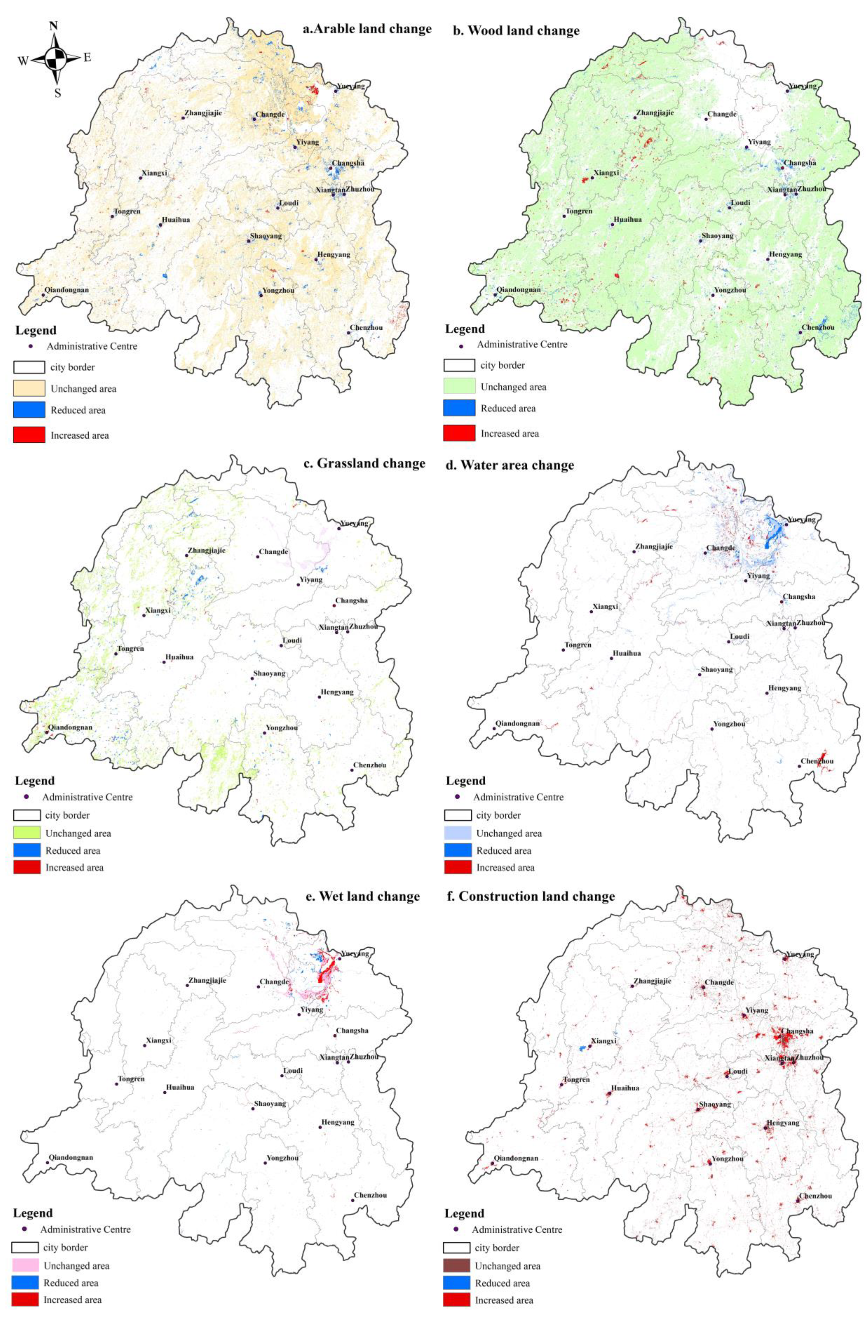
3.1.1. Spatio-Temporal Analysis
3.1.2. Land-Use Transfer Matrix Analysis
3.2. Analysis of ESV of the Dongting Lake Basin
3.2.1. Time Change Characteristics of the Total ESV
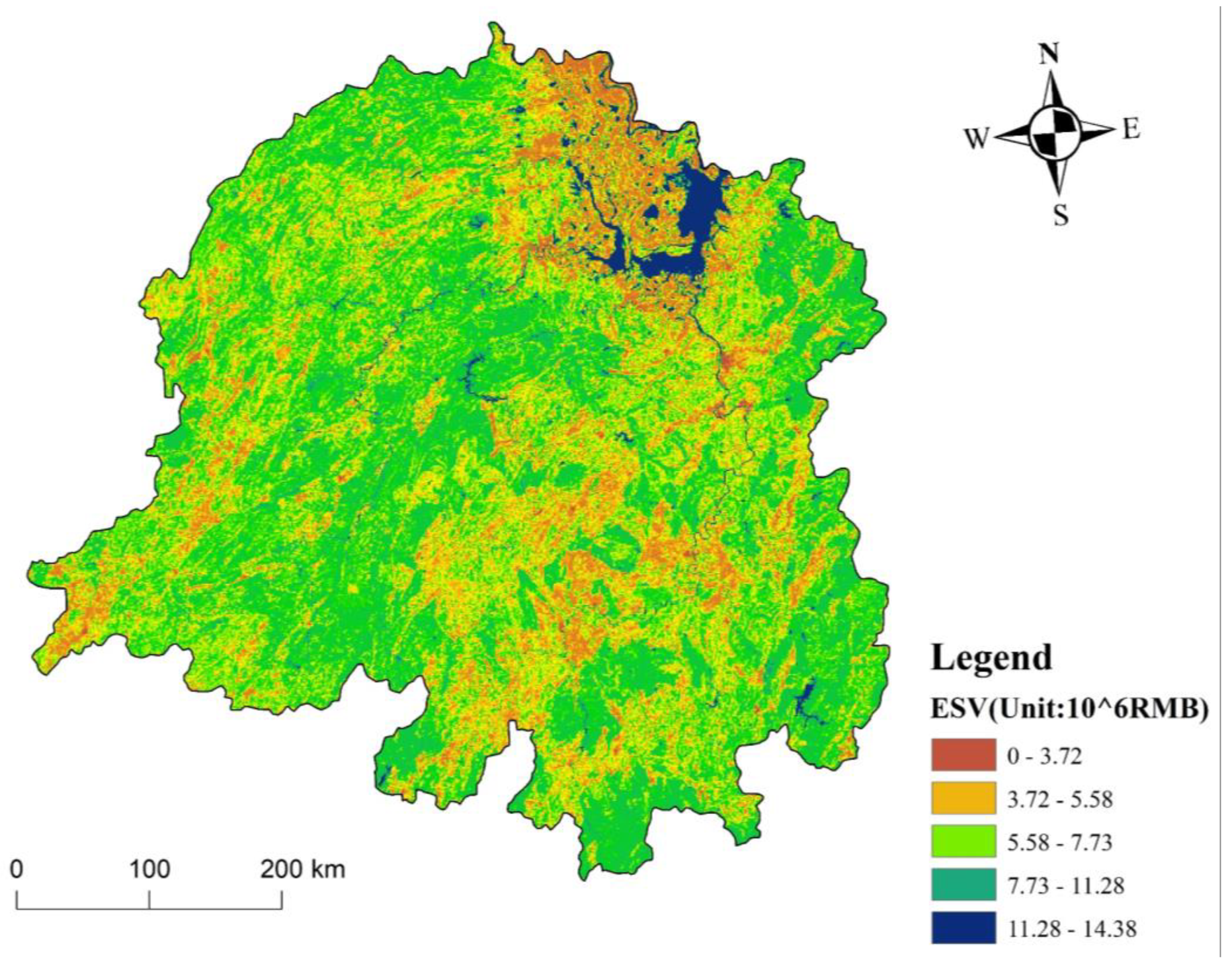
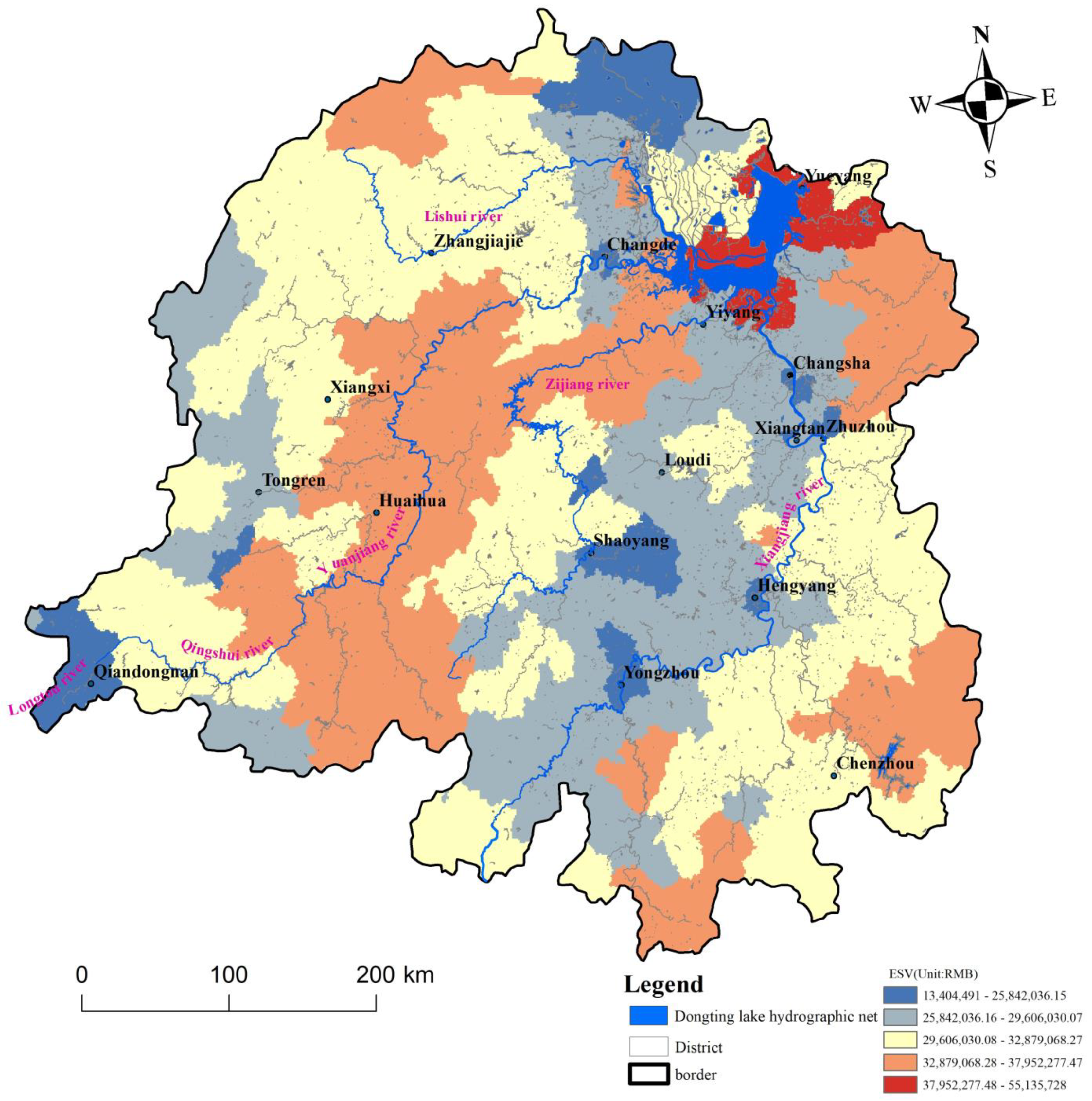
3.2.2. Spatial Pattern Characteristics of ESV
3.2.3. Temporal and Spatial Changes in Individual ESVs
Temporal Characteristics of Individual Ecological Services
Spatial Variation of the Value of Individual Ecological Services
3.3. The Exploration of Drive Factors
4. Discussion
4.1. The Determination of Evaluation Method and the Comparison of the Results
4.2. The ESV at the County Scale
4.3. Limitations of the Study
5. Conclusions
- (1)
- Apart from construction land, the land-use changes in the Dongting Lake Basin did not show significant changes in other land-use types. The main land-use type in the basin was forest land, with an area proportion of ≥ 60%. Construction land had the largest increase at 1.23%, with a notable trend of outward expansion. The area of arable land decreased the most, at only 0.88%.
- (2)
- During the study period, the conversions of various land types were markedly different. Forest and arable land were transformed into each other with comparable area proportions. Construction land occupied most of the share of forest and arable lands that were transferred out, resulting in a change in these two land-use types. A large area of grassland was transformed to forest and arable land, which was characterized by a rapid conversion speed. Water areas and wetlands were mainly transformed in. Construction land was mainly transformed in with the fastest conversion speed.
- (3)
- The overall ESV of the basin first increased and then decreased. However, the magnitude of the change was small. Forest and arable lands have continuously supported the ecosystem services of the Dongting Lake Basin, but there was a small reduction (to varying degrees) during the study period. The ESVs of the water areas and wetlands increased significantly, partially compensating for the overall ESV loss. In terms of the spatial distribution, the ESV was higher in areas adjacent to wetlands and water areas and were lower in areas adjacent to construction and arable lands. The ESV differentiation was notable.
- (4)
- The main ecological service functions included soil formation and protection, water conservation, gas exchange, climate regulation, and biodiversity protection. The value of the ecological service functions was generally greater than that of the productive functions. The differences in the distribution of various ESVs were closely related to the land-use types. The increase in construction land was the main factor driving the increase in the spatial distribution of the ecological service functions, such as soil formation, raw materials, biodiversity protection, and gas exchange.
Author Contributions
Funding
Institutional Review Board Statement
Informed Consent Statement
Data Availability Statement
Acknowledgments
Conflicts of Interest
References
- Ma, K.; Huang, X.R.; Liang, C.; Zhao, H.B.; Zhou, X.Y.; Wei, X.Y. Effect of land use/cover changes on runoff in the Min River watershed. River Res. Appl. 2020, 36, 749–759. [Google Scholar] [CrossRef]
- Mo, W.B.; Wang, Y.; Zhang, Y.X.; Zhuang, D.F. Impacts of road network expansion on landscape ecological risk in a megacity, China: A case study of Beijing. Sci. Total Environ. 2017, 574, 1000–1011. [Google Scholar] [CrossRef] [PubMed]
- Kim, I.; Arnhold, S.; Ahn, S.; Le, Q.B.; Kim, S.J.; Park, S.J.; Koellner, T. Land use change and ecosystem services in mountainous watersheds: Predicting the consequences of environmental policies with cellular automata and hydrological modeling. Environ. Modell. Softw. 2019, 122, 103982. [Google Scholar] [CrossRef]
- Chen, S.R.; Feng, Y.J.; Tong, X.H.; Liu, S.; Xie, H.; Gao, C.; Lei, Z.K. Modeling ESV losses caused by urban expansion using cellular automata and geographically weighted regression. Sci. Total Environ. 2020, 712, 136509. [Google Scholar] [CrossRef]
- Yushanjiang, A.; Zhang, F.; Yu, H.Y.; Kung, H. Quantifying the spatial correlations between landscape pattern and ecosystem service value: A case study in Ebinur Lake Basin, Xinjiang, China. Ecol. Eng. 2018, 113, 94–104. [Google Scholar] [CrossRef]
- Luo, Q.; Zhou, J.; Li, Z.; Yu, B. Spatial differences of ecosystem services and their driving factors: A comparation analysis among three urban agglomerations in China’s Yangtze River Economic Belt. Sci. Total Environ. 2020, 725, 138452. [Google Scholar] [CrossRef]
- Tae, G.K.; Choi, K.S. A study on water quality change by land use change using HSPF. Environ. Eng. Res. 2020, 25, 123–128. [Google Scholar]
- Shahid, L.; Firuza, M. Parametric Vine Copula Construction for Flood Analysis for Kelantan River Basin in Malaysia. Civil. Eng. J. 2020, 6, 1470–1491. [Google Scholar]
- Negasi, S.; Segnon, A.C.; Birhane, E. Ecosystem Service Values Changes in Response to Land-Use/Land-Cover Dynamics in Dry Afromontane Forest in Northern Ethiopia. Int. J. Environ. Res. Public Health 2019, 16, 4653. [Google Scholar]
- Yao, H.; Liu, H.; Ni, T.H. Estimation of the Value of Aquatic Ecosystem Services in the Coastal Area of Jiangsu Province, China. Integr. Environ. Asses. 2019, 15, 1012–1020. [Google Scholar] [CrossRef] [PubMed]
- Zalasiewicz, J.; Williams, M.; Steffen, W.; Crutzen, P. The new world of the anthropocene. Environ. Sci. Technol. 2010, 44, 2228–2231. [Google Scholar] [CrossRef]
- Karen, C.S.; Michail, F.; Burak, G.; Michael, K.R. A meta-analysis of global urban land expansion. PLoS ONE 2011, 6, e23777. [Google Scholar]
- Zhai, J.; Sun, X.Y.; Liu, F.; Shan, R.F.; Zhang, W.J. Spatio-temporal variation of land use and ecosystem service values and their impact factors in an urbanized agricultural basin since the reform and opening of China. Environ. Monit. Assess. 2019, 191, 1–14. [Google Scholar]
- Nayak, A.K.; Shahid, M.; Nayak, A.D.; Dhal, B.; Moharana, K.C.; Mondal, B.; Tripathi, R.; Mohapatra, S.D.; Bhattacharyya, P.; Jambhulkar, N.N.; et al. Assessment of ecosystem services of rice farms in eastern India. Ecol. Process. 2019, 8, 1–16. [Google Scholar] [CrossRef]
- Huang, A.; Xu, Y.Q.; Sun, P.L.; Zhou, G.Y.; Liu, C.; Lu, L.H.; Xiang, Y.; Wang, H. Land use/land cover changes and its impact on ecosystem services in ecologically fragile zone: A case study of Zhangjiakou City, Hebei Province, China. Ecol. Indic. 2019, 104, 604–614. [Google Scholar] [CrossRef]
- Cao, S.X.; Zhang, J.Z.; Su, W. Difference in the net value of ecological services between natural and artificial forests in China. Conserv. Biol. 2019, 33, 1076–1083. [Google Scholar] [CrossRef]
- Hu, M.M.; Li, Z.T.; Wang, Y.F.; Jiao, M.Y.; Li, M.; Xia, B.C. Spatio-temporal changes in ecosystem service value in response to land-use/cover changes in the Pearl River Delta. Resour. Conserv. Recycl. 2019, 149, 106–114. [Google Scholar] [CrossRef]
- Zhao, X.D.; He, Y.J.; Yu, C.; Xu, D.Y.; Zou, W.T. Assessment of Ecosystem Services Value in a National Park Pilot. Sustainability 2019, 11, 6609. [Google Scholar] [CrossRef]
- Geng, J.X.; Liang, C.Z. Analysis of the Internal Relationship between Ecological Value and Economic Value Based on the Forest Resources in China. Sustainability 2021, 13, 6795. [Google Scholar] [CrossRef]
- Thapa, S.; Wang, L.H.; Koirala, A.; Shrestha, S.; Bhattarai, S.; Nye, W.N. Valuation of Ecosystem Services from an Important Wetland of Nepal: A Study from Begnas Watershed System. Wetlands 2020, 40, 1071–1083. [Google Scholar] [CrossRef]
- Sun, C.Z.; Wang, Y.Y.; Zou, W. The marine ecosystem services values for China based on the emergy analysis method. Ocean. Coast. Manag. 2018, 161, 66–73. [Google Scholar] [CrossRef]
- Mo, W.B.; Zhao, Y.L.; Yang, N.; Xu, Z.G.; Zhao, W.P.; Li, F. Effects of Climate and Land Use/Land Cover Changes on Water Yield Services in the Dongjiang Lake Basin. ISPRS. Int. J. Geo-Inf. 2021, 10, 466. [Google Scholar] [CrossRef]
- Xie, G.D.; Lu, C.X.; Leng, Y.F.; Zheng, D.; Li, S.C. Ecological assets valuation of the Tibetan Plateau. J. Nat. Resour. 2003, 18, 189–196. (In Chinese) [Google Scholar]
- Yuan, B.D.; Fu, L.N.; Zou, Y.A.; Zhang, S.Q.; Chen, X.S.; Li, F.; Deng, Z.M.; Xie, Y.H. Spatiotemporal change detection of ecological quality and the associated affecting factors in Dongting Lake Basin, based on RSEI. J. Clean. Prod. 2021, 302, 126995. [Google Scholar] [CrossRef]
- Kong, L.Q.; Zheng, H.; Ouyang, Z.Y. Ecological protection and restoration of forest, wetland, grassland and cropland based on the perspective of ecosystem services: A case study in Dongting Lake Watershed. Acta Ecol. Sin. 2019, 39, 8903–8910. (In Chinese) [Google Scholar]
- Wu, Y.B.; Xue, L.Q.; Liu, Y.H. Local and regional flood frequency analysis based on hierarchical Bayesian model in Dongting Lake Basin, China. Water Sci. Eng. 2019, 12, 253–262. [Google Scholar] [CrossRef]
- Zhang, Y.; Liu, C.M.; Liu, X.J.; Xu, X.; Wen, Z. Atmospheric nitrogen deposition around the Dongting Lake, China. Atmos. Environ. 2019, 207, 197–204. [Google Scholar] [CrossRef]
- Yin, G.Y.; Liu, L.M.; Jiang, X.L. The sustainable arable land use pattern under the tradeoff of agricultural production, economic development, and ecological protection—an analysis of Dongting Lake basin, China. Environ. Sci. Pollut. Res. 2017, 24, 25329–25345. [Google Scholar] [CrossRef]
- Zhang, J.H.; Feng, Z.M.; Jiang, L.G. Progress on Studies of Land Use/Land Cover Classification Systems. Resour. Sci. 2011, 33, 1195–1203. (In Chinese) [Google Scholar]
- Chen, W.X.; Zhao, H.B.; Li, J.F.; Zhu, L.J.; Wang, Z.Y.; Zeng, J. Land use transitions and the associated impacts on ecosystem services in the Middle Reaches of the Yangtze River Economic Belt in China based on the geo-informatic Tupu method. Sci. Total Environ. 2020, 701, 134690. [Google Scholar] [CrossRef] [PubMed]
- Han, X.J.; Yu, J.L.; Shi, L.N.; Zhao, X.C.; Wang, J.J. Spatiotemporal evolution of ecosystem service values in an area dominated by vegetation restoration: Quantification and mechanisms. Ecol. Indic. 2020, 131, 108191. [Google Scholar] [CrossRef]
- Ning, J.; Liu, J.Y.; Kuang, W.H.; Xu, X.L.; Zhang, S.W.; Yan, C.Z.; Li, R.D.; Wu, S.X.; Hu, Y.F.; Du, G.M.; et al. Spatiotemporal patterns and characteristics of land-use change in China during 2010–2015. J. Geogr. Sci. 2018, 28, 547–562. [Google Scholar] [CrossRef]
- Zhang, Y.Y.; Xia, J.; Yu, J.J.; Randall, M.; Zhang, Y.C.; Zhao, T.T.G.; Pan, X.Y.; Zhai, X.Y.; Shao, Q.X. Simulation and assessment of urbanization impacts on runoff metrics: Insights from landuse changes. J. Hydrol. 2020, 560, 247–258. [Google Scholar] [CrossRef]
- González-Moradas, M.D.R.; Viveen, W. Evaluation of ASTER GDEM2, SRTMv3. 0, ALOS AW3D30 and TanDEM-X DEMs for the Peruvian Andes against highly accurate GNSS ground control points and geomorphological-hydrological metrics. Remote Sens. Environ. 2020, 237, 111509. [Google Scholar] [CrossRef]
- Zhao, S.M.; Qi, D.N.; Li, R.P.; Cheng, W.M.; Zhou, C.H. Performance comparison among typical open global DEM datasets in the Fenhe River Basin of China. Eur. J. Remote Sens. 2021, 54, 145–157. [Google Scholar] [CrossRef]
- Mouratidis, A.; Ampatzidis, D. European Digital Elevation Model Validation against Extensive Global Navigation Satellite Systems Data and Comparison with SRTM DEM and ASTER GDEM in Central Macedonia (Greece). ISPRS Int. J. Geo-Inf. 2019, 8, 108. [Google Scholar] [CrossRef]
- Ji, W.; Wang, Y.; Zhuang, D.F.; Song, D.P.; Shen, X.; Wang, W.; Li, G. Spatial and temporal distribution of expressway and its relationships to land cover and population: A case study of Beijing, China. Transp. Res. Part D Transp. Environ. 2014, 32, 86–96. [Google Scholar] [CrossRef]
- Liu, J.Y.; Zhang, Z.X.; Xu, X.L.; Kuang, W.H.; Zhou, W.C.; Zhang, S.W.; Li, R.D.; Yan, C.Z.; Yu, D.S.; Wu, S.X.; et al. Spatial patterns and driving forces of land use change in China during the early 21st century. J. Geocr. Sci. 2010, 20, 483–494. [Google Scholar] [CrossRef]
- Costanza, R.; D’Arge, R.; Groot, R.D.; Farber, S.; Grasso, M.; Hannon, B.; Limburg, K.; Naeem, S.; O’Neill, R.; Paruelo, J.; et al. The value of the world’s ecosystem services and natural capital. Nature 1997, 387, 253–260. [Google Scholar] [CrossRef]
- Gaodi, X.; Caixia, Z.; Leiming, Z.; Wenhui, C.; Shimei, L. Improvement of the evaluation method for ecosystem service value based on per unit area. J. Nat. Resour. 2015, 30, 1243–1253. (In Chinese) [Google Scholar]
- Liu, Y.B.; Hou, X.Y.; Li, X.W.; Song, B.Y.; Wang, C. Assessing and predicting changes in ecosystem service values based on land use/cover change in the Bohai Rim coastal zone. Ecol. Indic. 2020, 111, 106004. [Google Scholar] [CrossRef]
- Di, X.H.; Hou, X.Y.; Xu, X.L.; Wu, L. Study on Spatial-Temporal Characteristics of Ecosystem Service Value in Shandong Province. Geogr. Geo-Inf. Sci. 2013, 29, 116–120. (In Chinese) [Google Scholar]
- Wei, S.; Deng, X.Z. Land use/land cover change and ecosystem service provision in China. Sci. Total Environ. 2017, 576, 705–719. [Google Scholar]
- Marsboom, C.; Vrebos, D.; Staes, J.; Meire, P. Using dimension reduction PCA to identify ecosystem service bundles. Ecol. Indic. 2018, 87, 209–260. [Google Scholar] [CrossRef]
- Wang, Y.H.; Dai, E.F.; Yin, L.; Ma, L. Land use/land cover change and the effects on ecosystem services in the Hengduan Mountain region, China. Ecosyst. Serv. 2018, 34, 55–67. [Google Scholar] [CrossRef]
- Jiao, M.Y.; Hu, M.M.; Xia, B.C. Spatiotemporal dynamic simulation of land-use and landscape-pattern in the Pearl River Delta, China. Sustain. Cities Soc. 2019, 49, 101581. [Google Scholar] [CrossRef]
- Ma, L.; Sun, R.; Kazemi, E.; Pang, D.; Zhang, Y.; Sun, Q.; Zhou, J.; Zhang, K. Evaluation of Ecosystem Services in the Dongting Lake Wetland. Water 2019, 11, 2564. [Google Scholar] [CrossRef]
- Liu, J.; Fu, B.; Zhang, C.H.; Hu, Z.P.; Wang, Y.K. Assessment of Ecosystem Water Retention and Its Value in the Upper Reaches of Minjiang River Based on InVEST Model. Resour. Environ. Yangtze Basin 2019, 28, 578–585. [Google Scholar]
- Xiong, Y.; Zhang, F.M.; Gong, C.A.; Luo, P. Spatial-temporal Evolvement of Ecosystem Service Value in Hunan Province Based on LUCC. Resour. Environ. Yangtze Basin 2018, 27, 1398–1408. (In Chinese) [Google Scholar]
- Deng, C.X.; Zhong, X.L.; XIE, B.G.; Wan, Y.L.; Song, X.W. Spatial and temporal changes of land ecosystem service value in Dongting Lake area in 1995–2015. Georaphical Res. 2019, 38, 844–855. (In Chinese) [Google Scholar]


| T2 | Pi+ | Reduced | |||||
|---|---|---|---|---|---|---|---|
| … | |||||||
| … | |||||||
| … | |||||||
| ⋮ | ⋮ | ⋮ | ⋮ | ⋮ | ⋮ | ⋮ | |
| … | |||||||
| … | 1 | ||||||
| Increased | … | ||||||
| Ecological Service Function | Forest | Grass Land | Arable Land | Wetland | Water Area | Unused Land |
|---|---|---|---|---|---|---|
| Gas exchange | 10617.11 | 2426.77 | 1516.73 | 5460.23 | 0 | 0 |
| Climate regulation | 8190.34 | 2730.11 | 2699.78 | 51872.17 | 1395.39 | 0 |
| Water conservation | 9707.07 | 2426.77 | 1820.08 | 47018.63 | 61821.91 | 91.00 |
| Soil formation and protection | 11830.49 | 5915.25 | 4428.85 | 5187.22 | 30.33 | 60.67 |
| Waste disposal | 3973.83 | 3973.83 | 4974.87 | 55148.30 | 55148.30 | 30.33 |
| Biodiversity | 9889.08 | 3306.47 | 2153.76 | 7583.65 | 7553.32 | 1031.38 |
| Food production | 303.34 | 910.04 | 3033.46 | 910.038 | 303.35 | 30.33 |
| Raw materials | 7887.00 | 151.67 | 303.346 | 212.34 | 30.33 | 0 |
| Entertainment | 3882.83 | 121.34 | 30.3346 | 16835.70 | 13165.22 | 30.33 |
| 1990 | 1995 | 2000 | 2005 | 2010 | 2015 | Changes from 1990 to 2015 | |
|---|---|---|---|---|---|---|---|
| Arable land | 28.76 | 28.48 | 28.65 | 28.54 | 28.17 | 27.88 | −0.88 |
| Forest | 61.59 | 61.70 | 61.50 | 61.55 | 61.63 | 61.37 | −0.22 |
| Grassland | 5.28 | 5.34 | 5.28 | 5.15 | 4.94 | 4.90 | −0.38 |
| Water area | 2.48 | 2.60 | 2.58 | 2.65 | 2.68 | 2.59 | 0.11 |
| Wetland | 0.73 | 0.66 | 0.72 | 0.71 | 0.74 | 0.86 | 0.13 |
| Construction land | 1.15 | 1.21 | 1.26 | 1.39 | 1.82 | 2.38 | 1.23 |
| Unused land | 0.01 | 0.01 | 0.01 | 0.01 | 0.01 | 0.02 | 0.01 |
| Arable Land | Forest Land | Grassland | Water Area | Wetland | Construction Land | Unused Land | Total | |
|---|---|---|---|---|---|---|---|---|
| Arable land | 70,421.87 | 1499.35 | 101.95 | 717.61 | 116.07 | 1831.12 | 2.81 | 74,690.77 |
| Forest land | 1190.20 | 156,631.36 | 363.23 | 307.55 | 19.15 | 1394.82 | 25.32 | 159,931.64 |
| Grassland | 248.25 | 1052.28 | 12,228.11 | 33.71 | 39.29 | 97.91 | 0.98 | 13,700.52 |
| Water area | 255.84 | 96.16 | 19.69 | 5386.96 | 640.78 | 51.50 | 0.17 | 6451.10 |
| Wetland | 197.54 | 12.16 | 3.81 | 265.34 | 1403.13 | 9.40 | 1.29 | 1892.67 |
| Construction land | 79.73 | 76.14 | 6.68 | 25.67 | 3.86 | 2794.39 | 0.23 | 2986.71 |
| Unused land | 1.45 | 2.85 | 1.22 | 0.66 | 0.20 | 2.41 | 11.94 | 20.72 |
| Total | 72,394.88 | 159,370.30 | 12,724.69 | 6737.49 | 2222.48 | 6181.55 | 42.74 | 259,674.13 |
| LCDI | −0.12% | −0.01% | −0.28% | 0.18% | 0.70% | 4.28% | ------ | ------- |
| BLCDI | 0.33% | 0.15% | 0.57% | 1.50% | 2.77% | 4.79% | ------ | ------- |
| Land-Use Type | ESV (1010 RMB) | Relative Rate of Change from 1990 to 2015 | |||||
|---|---|---|---|---|---|---|---|
| 1990 | 1995 | 2000 | 2005 | 2010 | 2015 | ||
| Arable land | 15.66 | 15.50 | 15.60 | 15.53 | 15.33 | 15.18 | −3.07% |
| Forest land | 106.01 | 106.19 | 105.85 | 105.94 | 106.07 | 105.63 | −0.35% |
| Grassland | 3.01 | 3.05 | 3.01 | 2.94 | 2.82 | 2.79 | −7.12% |
| Water area | 9.00 | 9.42 | 9.33 | 9.61 | 9.71 | 9.40 | 4.44% |
| Wetland | 3.60 | 3.25 | 3.58 | 3.49 | 3.68 | 4.23 | 17.42% |
| Total | 137.27 | 137.42 | 137.37 | 137.51 | 137.62 | 137.23 | −0.03% |
| Individual Ecological Service Function | 1990 | 1995 | 2000 | 2005 | 2010 | 2015 | 1990~2015 (%) |
|---|---|---|---|---|---|---|---|
| Gas exchange | 13.51 | 13.51 | 13.48 | 13.47 | 13.46 | 13.44 | −0.07 |
| Climate regulation | 12.07 | 11.99 | 12.04 | 12.00 | 12.01 | 12.10 | 0.03 |
| Water conservation | 16.10 | 16.17 | 16.17 | 16.23 | 16.27 | 16.26 | 0.16 |
| Soil formation and protection | 16.86 | 16.84 | 16.82 | 16.78 | 16.74 | 16.71 | −0.15 |
| Waste treatment | 11.09 | 11.11 | 11.15 | 11.19 | 11.20 | 11.21 | 0.12 |
| Biodiversity protection | 13.48 | 13.49 | 13.47 | 13.46 | 13.44 | 13.42 | −0.06 |
| Food production | 2.12 | 2.10 | 2.11 | 2.10 | 2.08 | 2.07 | −0.05 |
| Raw materials | 9.37 | 9.38 | 9.35 | 9.35 | 9.35 | 9.34 | −0.04 |
| Entertainment | 5.40 | 5.41 | 5.41 | 5.43 | 5.45 | 5.46 | 0.05 |
| Socio-Economic Factors | Natural Factors | ||||||||||||
|---|---|---|---|---|---|---|---|---|---|---|---|---|---|
| GDP | Population | Primary Industry | Secondary Industry | Tertiated Industry | Investment in Fixed Assets | Per Capita Income | Agricultural Output | Social Merchandise Retail | Fiscal Expenditure | Temperature | DEM | Rainfall | |
| F1 | 0.979 | 0.731 | 0.255 | 0.953 | 0.953 | 0.974 | 0.897 | 0.147 | 0.920 | 0.900 | 0.403 | −0.458 | 0.428 |
| F2 | −0.149 | 0.418 | 0.868 | −0.104 | −0.247 | −0.169 | −0.229 | 0.888 | −0.302 | −0.258 | 0.598 | −0.637 | 0.399 |
| F3 | 0.032 | 0.417 | 0.385 | −0.053 | 0.068 | 0.053 | −0.171 | 0.402 | 0.073 | 0.163 | −0.599 | 0.492 | −0.361 |
Publisher’s Note: MDPI stays neutral with regard to jurisdictional claims in published maps and institutional affiliations. |
© 2021 by the authors. Licensee MDPI, Basel, Switzerland. This article is an open access article distributed under the terms and conditions of the Creative Commons Attribution (CC BY) license (https://creativecommons.org/licenses/by/4.0/).
Share and Cite
Yang, N.; Mo, W.; Li, M.; Zhang, X.; Chen, M.; Li, F.; Gao, W. A Study on the Spatio-Temporal Land-Use Changes and Ecological Response of the Dongting Lake Catchment. ISPRS Int. J. Geo-Inf. 2021, 10, 716. https://doi.org/10.3390/ijgi10110716
Yang N, Mo W, Li M, Zhang X, Chen M, Li F, Gao W. A Study on the Spatio-Temporal Land-Use Changes and Ecological Response of the Dongting Lake Catchment. ISPRS International Journal of Geo-Information. 2021; 10(11):716. https://doi.org/10.3390/ijgi10110716
Chicago/Turabian StyleYang, Nan, Wenbo Mo, Maohuang Li, Xian Zhang, Min Chen, Feng Li, and Wanchao Gao. 2021. "A Study on the Spatio-Temporal Land-Use Changes and Ecological Response of the Dongting Lake Catchment" ISPRS International Journal of Geo-Information 10, no. 11: 716. https://doi.org/10.3390/ijgi10110716
APA StyleYang, N., Mo, W., Li, M., Zhang, X., Chen, M., Li, F., & Gao, W. (2021). A Study on the Spatio-Temporal Land-Use Changes and Ecological Response of the Dongting Lake Catchment. ISPRS International Journal of Geo-Information, 10(11), 716. https://doi.org/10.3390/ijgi10110716