Article

Removal of Riprap within Channelized Rivers: A Solution for the Restoration of Lateral Channel Dynamics and Bedload Replenishment?

1
Université Clermont Auvergne, CNRS, GEOLAB, 63000 Clermont-Ferrand, France
2
Université Paris 1, CNRS, LGP, 94320 Thiais, France
3
VEODIS 3D, 63400 Chamalières, France
4
Université Clermont Auvergne, CNRS, MSH, 63000 Clermont-Ferrand, France
5
Conservatoire d’Espaces Naturels d’Auvergne, 63200 Mozac, France
*
Authors to whom correspondence should be addressed.
Appl. Sci. 2023, 13(5), 2981; https://doi.org/10.3390/app13052981
Submission received: 31 December 2022 / Revised: 10 February 2023 / Accepted: 14 February 2023 / Published: 25 February 2023

Abstract

:
Riverbank erosion is an essential morphodynamic process for the improvement of river health and the ecohydrogeomorphological functioning of alluvial rivers. Lateral channel dynamics and sediment supply caused by bank erosion largely create and maintain heterogeneous in-channel habitats for fauna and aquatic or riparian plant species. However, humans very early started to stabilize riverbanks in order to favour navigation or to prevent valuable land and infrastructures close to the channel from eroding. During the 20th century, bank protection works such as riprap considerably increased and blocked lateral channel erosion, causing a loss of local sediment supply, which in turn resulted in a decrease in local bedload transport and channel incision. The aim of the article is to evaluate to what extent riprap removal may be an efficient restoration measure in terms of the reactivation of bank erosion and the replenishment of the local bedload in gravel-bed floodplain rivers with a sufficient amount of freedom space. An experimental in situ restoration approach was chosen. First, riprap was removed at two geomorphologically contrasting sites on the Allier River, France. Second, bank retreat was monitored, and the volumes eroded were quantified using photogrammetric and LiDAR surveys. Third, in the case of post-restoration bank erosion, grain size and morphological channel evolution analyses were carried out. Our results suggested that the removal of riprap is an effective measure for certain but not all channelized floodplain reaches. The geomorphological and sedimentary contexts are two criteria that should be considered when selecting sites for restoration. Thus, this study helps river managers to better target the criteria to be taken into account for the selection of sites with high potential for the restoration of lateral channel dynamics.

1. Introduction

Riverbank erosion within alluvial river systems is an important morphodynamic process that sustains river health and its associated ecogeomorphological functioning. At the catchment scale, bank erosion contributes to the dynamic equilibrium of the fluvial system through the transfer of sediments from the headwaters to the river mouths [1,2,3]. Modifications of channel morphology and sediment supply caused by bank erosion largely create and maintain heterogeneous in-channel habitats for fauna (macroinvertebrates, fish, and birds) and aquatic or riparian plant species [3]. However, humans very early started to stabilize riverbanks to benefit navigation or to prevent valuable land and infrastructures close to the channel from eroding [4]. During the 20th century, bank protection works such as riprap considerably increased along river channels, leading to their stabilization [5,6]. At the reach scale, the blocking of lateral channel dynamics implies a loss of local sediment supply, which in turn may result in a decrease in local bedload transport, the subsequent incision of the channel, and the coarsening of the channel bed sediments, leading to progressive bed armouring [7].
The erodible river corridor management approach [8] based on the French ‘streamway concept’ [9,10], which evolved into the ‘espace de liberté concept’ [11] and was translated in the literature as ‘freedom space for rivers’ [12,13] or ‘fluvial territory’ [5], represents a process-based restoration approach [14,15,16,17,18] that defines the minimal space within a river corridor in which fluvial processes can freely occur without threatening human interests beyond the fluvial ecosystem and the ecosystem services it provides to society. Thus, lateral channel migration and flooding may be preserved within a delimited area, maintaining or restoring fluvial and ecological processes, or it may sometimes require the removal of bank protections. Although being a sustainable solution to preserve and restore rivers, the restoration of a fluvial freedom space through the removal of riprap remains largely underrepresented among restoration measures, as shown by the low recurrence of these projects listed in European restoration project databases and in the scientific literature (Table 1).
Several reasons for this lack of representation were identified:
  • The removal of riprap is not a measure that can be applied to all river courses or reaches. The definition of a freedom space presupposes that the river can freely erode and that its divagation would not conflict with strong anthropic issues present on its floodplain [8,27,28].
  • Despite rising awareness that bank erosion may represent a desirable attribute of rivers, sensu Florsheim et al. 2001 [3], bank erosion is still often seen by societies as a negative process that must be prevented, and not only in cases where river margins and floodplains are urbanized and transformed into agricultural land. Thus, the delimitation of a freedom space in which the river can erode its banks requires, to be accepted, knowledge of the functioning of the river, both from the public authorities in charge of river management and from the affected populations [29]. It may also take many years of perseverance to convince riverside landowners and stakeholders of the usefulness of bank protection removal, as experienced on the Garonne River, France [30].
  • Consequently, broad communication about the objectives and benefits of restoration projects is recognized as essential for a successful outcome. Knowledge sharing around restoration projects, i.e., sharing objectives and techniques, including the monitoring methods to be applied and the final results that validate or invalidate the success of the restoration, is clearly considered essential for the efficient hydrogeomorphological and ecological restoration of river systems [14,15,18]. However, concerning pre- and post-restoration monitoring, a disparity in the level of information provided was observed (Table 1).
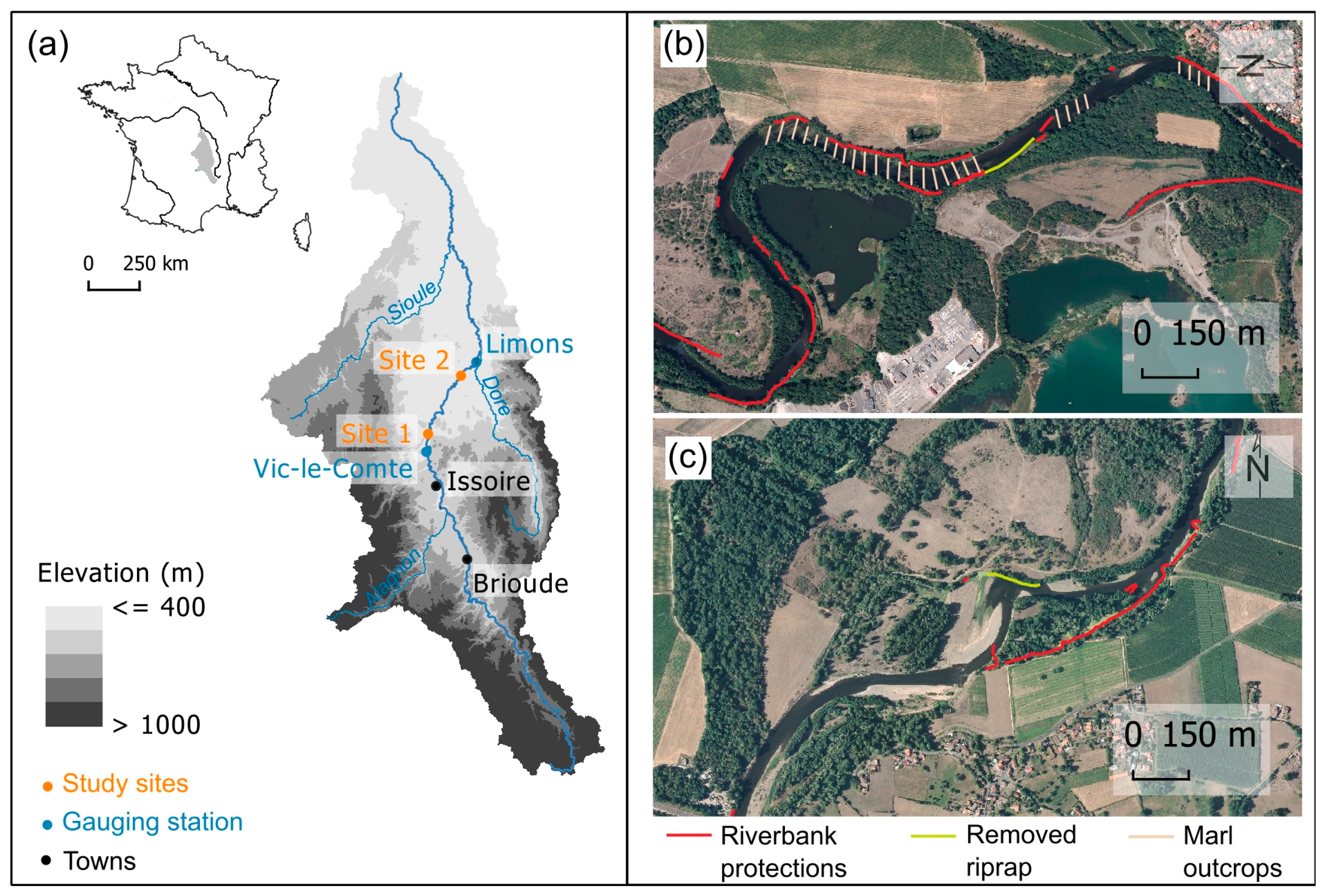
In this context, the objective of the article is to evaluate to what extent riprap removal may be an efficient restoration measure in terms of the reactivation of bank erosion and lateral channel dynamics as well as the replenishment of the local bedload in gravel-bed floodplain rivers with sufficiently large freedom space. To do so, an experimental in situ restoration approach on the Allier River, France, was chosen.

2. Study Area

The Allier River is a meandering gravel-bed river flowing over 410 km from south to north in Massif Central, France, to its confluence with the Loire River (Figure 1a). In its upstream part, the Allier River flows within its gorges and drains the ancient basement of the Hercynian Mountains, composed of granite and gneiss, as well as more recent volcanic rocks. From the town of Brioude until its confluence with the Loire River, the Allier River flows on its alluvial plain edified within two geological grabens filled by sedimentary rocks, mainly marl and limestone, in response to the formation of the Alps during the Oligocene period [31]. The two grabens are separated by a short gorge section, approximately 20 km long, cut into a granitic horst near the town of Issoire. Within the study area, the hydrological regime is determined by the presence or absence of rainfall events caused by Mediterranean, oceanic, and continental atmospheric influences [32].
A recent diachronic analysis of the middle Allier River between the town of Brioude just downstream of the Allier River gorges and the confluence with the Dore River showed a mean incision of 0.86 m between 1934–1935 and 2020, a narrowing of the active channel width by 25%, and a decrease in its lateral mobility by 68% between 1954 and 2016 [33]. It confirmed more generalized observations of an earlier technical report that recorded, between 1934–1936 and 1980–1995, a channel incision caused by a bedload deficit of the Allier River [34]. In 2017 and 2019, the Conservatoire d’espaces naturels d’Auvergne (CEN Auvergne), a regional nature conservation association, obtained all necessary permissions to remove riprap within two contrasting reaches of the middle Allier River and to restore its freedom space as suggested in the 1990s for the Loire and Allier rivers by Bazin and Gautier [35].

2.1. Site 1

A stretch of riprap with a length of 190 m was removed from Site 1 (local toponym: Bellerive) in September 2017, and trees were cut but not stumped [36]. This riprap was originally added in 1884 under the request of the owner of the former Bellerive castle on the right bank floodplain. Today, the site is part of a reach that is laterally fixed by an important linear bank protection to protect bridges, wellfields providing drinking water, and gravel pits located along the main channel (Figure 1b). At this site, the channel width measured on the IGN orthophotograph of 2016, before restoration works, was 44 m, and the water slope measured in 2020 was 0.0015 m/m. Between 1935 and 2020, the mean channel incision was approximately 1 m [33], and important marl outcrops were observed at low flows over the entire bed upstream and downstream of the restored bank. The gauging station of Vic-le-Comte, 12 km upstream of Site 1, which is representative of the discharge regime at this site, recorded an interannual discharge of 60.5 m3/s and a two-year flood of 436 m3/s (“https://hydro.eaufrance.fr (accessed on 15 February 2023)”). On the basis of the width of the active channel before the restoration works, the water slope in 2020, and the Q2 discharge, the calculated specific stream power was 146 W/m2 (Table 2).

2.2. Site 2

A stretch of riprap with a length of 140 m was removed from Site 2 (local toponym: Île des Cailloux) two years after the first site, in September 2019, and trees were cut but not stumped [37]. This riprap was built much more recently to protect a gravel mining extraction platform installed between 1974 and 1977. The gravel extraction present until the beginning of the 1990s was located just upstream of the mining extraction platform and its protected riverbank. Channel enlargement, still present today, is evidence of this human in-channel activity. Before the restoration works, the active channel width was 43 m (measured on the IGN orthophotograph of 2019), and an incision of 1.44 m was recorded between 1935 and 2020 [33]. The water surface slope was 0.0015 m/m in 2020. The site is part of a reach with lateral dynamics upstream and downstream of the restored bank without marl outcrops in the channel (Figure 1c). The closest gauging station of Limons, located 10 km downstream of Site 2, registered an interannual discharge of 69 m3/s and a two-year flood of 396 m3/s (“https://hydro.eaufrance.fr (accessed on 15 February 2023)”). On the basis of the width of the active channel before the works, the water slope in 2020, and the Q2 discharge, the specific stream power was 135 W/m2. Additionally, from the topobathymetric surveys carried out at Site 2, it was possible to calculate the barfull and bankfull stages from the rating curves (“http://www.bedloadweb.com (accessed on 15 February 2023)”), which corresponded to 156 m3/s and 789 m3/s, respectively (Table 2).

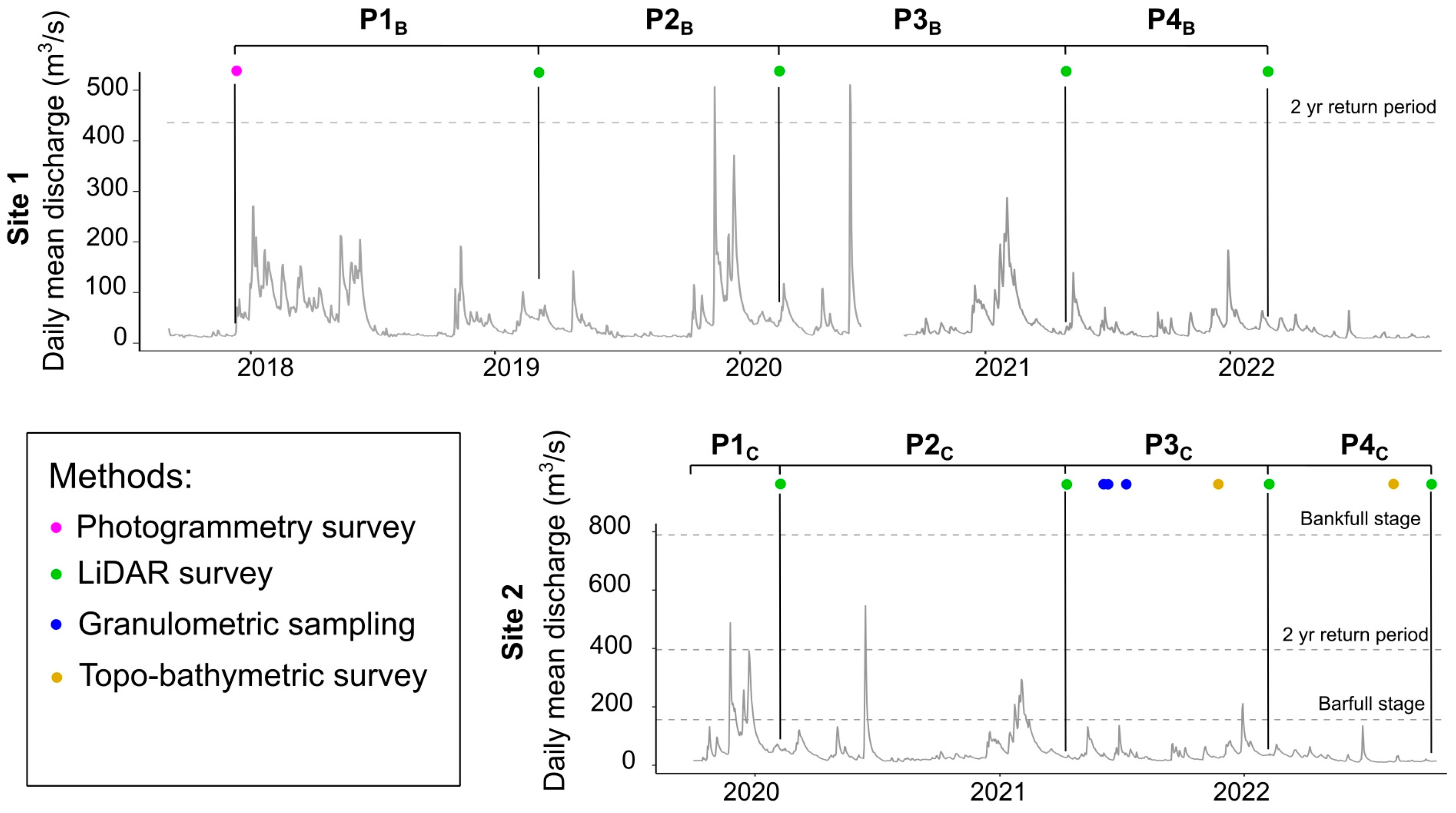
2.3. Evolution of Discharge over the Study Period

Over the entire study period, from November 2017 to February 2022 at Site 1 and from September 2019 to October 2022 at Site 2, the maximum water discharge, with a return period of 2 years, occurred between late 2019 and mid-2020, corresponding to the P2B-P3B periods at Site 1 and P1C-P2C periods at Site 2 (Figure 2). These hydrologic events did not reach the bankfull stage. The other recorded hydrologic events were less intense, with a maximum exceeding the barfull stage at Site 2 (February 2021 in the P2C period and December 2021 in the P3C period).

3. Methods

The removal of riprap was organized by the CEN Auvergne and carried out by a private company. Post-restoration monitoring was organized into two main steps. The first step was to assess the reactivation of bank erosion. For this purpose, digital elevation models (DEMs) obtained from either photogrammetric or LiDAR surveys were compared to quantify bank erosion after riprap removal at each site in terms of linear bank retreat as well as in the volume of sediment eroded and injected into the channel. If lateral channel dynamics are reactivated, then the second step is to assess its effect on bedload replenishment through channel readjustment and lateral inputs.

3.1. Step 1: Bank Erosion Reactivation Analysis

Post-riprap removal bank erosion reactivation was analysed by comparing the DEMs of restored banks. These DEMs were carried out using either of the photogrammetric Structure from Motion [38,39] or LiDAR methods. During the acquisition phases, a Trimble R10 RTK GPS base station was used to obtain the precise positioning of the DEMs. Then, each point cloud was interpolated using either the TIN or natural neighbour method.
Using ArcGIS, the DEMs obtained were subsequently compared two-by-two by considering only those areas above the highest water surface elevation between the two dates compared. As a result, for the DEMold and DEMnew areas above the highest water surface elevation, the comparison corresponded to ‘DEMnew–DEMold’. In the case where the DEMold areas were above the highest water surface elevation, and the DEMnew areas were below the highest water surface elevation, the comparison corresponded to ‘water surface elevation—DEMold’. In contrast, when the DEMold areas were below the highest water surface elevation and the DEMnew areas were above the highest water surface elevation, the comparison corresponded to ‘DEMnew—water surface elevation’. Additionally, each DEM of difference (DoD) was assigned a detection threshold of channel change (LoD), which corresponded to the propagated error [40] as follows:
LoD   = ( DEM old _ error ) 2 + ( DEM new _ error ) 2
where DEMold_error and DEMnew_error correspond to the RMSE of each method.
Where bank erosion was significant, the total eroded volumes were calculated. For this purpose, a DEM of the channel bed was defined on the basis of the talweg line from the topobathymetric survey.

3.2. Step 2: Bedload Replenishment Analysis

3.2.1. Morphological Channel Change Analyses

In order to highlight the channel readjustments after riprap removal, a channel planform analysis was carried out and compared to two control reaches with similar morphological characteristics but only very little impact from riverbank protections such as riprap (Table 3 and Figure 3).
Yearly satellite images obtained from the Spot satellites or aerial orthophotograph and made available by the French ‘Institut National de l’Information Géographique et forestière’ (IGN) were used.
The active channel was defined as the wetted channel, including bare and sparsely vegetated alluvial bars frequently reworked by floods. For each site and each date, the active channel was digitized at the same scale (1:4000). Three geomorphological indices were compared between study sites and control reaches: active channel width (m), bar area (m2/m of channel centreline), and bank erosion (m2/m of bank linear). Adjustments of the active channel width at study sites were compared to the channel widths measured every 250 m at each control reach. Bank erosion areas were computed, taking into account a mean digitalization error [41].
Additionally, bathymetric surveys were carried out to document the vertical evolution of the channel. For this purpose, the profiles resulting from the topobathymetric campaigns were compared using the software R and its package, Riverbed [42].

3.2.2. Grain Size Analysis

During the low-water stage, a grain size analysis campaign was carried out. First, to determine the grain size distribution of the bank, a volumetric granulometric analysis was performed. For this purpose, eight profiles were positioned along the bank. Each profile position was recorded with a GEOX7 GPS. First, each bank profile was stripped to reveal the underlying bank structure. Then, a stratigraphic description was performed. Each stratigraphic layer was sampled except where clays and silts dominated, which was very rare. Sample particles with a b-axis greater than 9 cm were measured in situ. The rest of the samples were taken to the laboratory, oven-dried, and sieved according to the Wentworth size classes.
In addition to the riverbank, three geomorphological in-channel units were sampled: the head of the opposite point bar as well as the riffles immediately upstream and downstream. For each of these three units, the b-axis of 200 particles was measured with a calliper according to the surface particle size analysis proposed by Wolman (1954) [43].

4. Site-Specific Operations

4.1. Site 1

Following the methodological framework, the first operations consisted of establishing the DEMs of the banks. The first topographic survey was carried out two months after the end of the restoration works in November 2017. Thus, it constituted a reference before any bank erosion. For the next topographic acquisition campaign in February 2019, the stumps left in place during the restoration works quickly resprouted and caused the rapid development of dense vegetation hiding the bank’s topography. Consequently, the choice was made to further record topographic data (Table 4) using a LiDAR.
Although comparison between LiDAR-derived DEMs was not a problem, an altitudinal fixed error between the photogrammetric and LiDAR-derived DEMs with a mean of 1.10 m (SD of 0.05 m) was identified by the comparison of 55 points located on the top bank flat where no morphological change was detected, i.e., in the threshold of detection change (LoD) for all subsequent LiDAR campaigns. Therefore, this source of error was also included in the LoD (Equation (1)):
LoD = ( ( RMSE Photogrammetry ) 2 + ( σ n ) 2 ) 2 + ( RMSE LiDAR ) 2
where σ is the standard deviation of the altitudinal fixed error and n is the number of control points. Finally, the minimum level of change detection (LoD) for photogrammetry–LiDAR comparisons was ±0.073 m, and it was ±0.085 m for LiDAR–LiDAR comparisons.

4.2. Site 2

At Site 2, only the LiDAR method was applied for the acquisition of topographic points (Table 5). The minimum level of change detection (LoD) was ±0.085 m. Rising water levels occurred shortly after bank restoration works (2019), preventing the first topographical data acquisition campaign immediately after bank restoration. However, an interpolation of points (TIN method) between topographic points obtained in July 2018 and topographic points of the floodplain obtained in February 2020 using LiDAR permitted the reconstruction of the floodplain’s elevation before erosion. In addition, due to the significant bank retreat recorded between the two first periods recorded (P1C and P2C), the total eroded volumes were calculated.
Because the reactivation of bank erosion was significant at Site 2 after the first two monitoring periods, step 2 of the methodological approach was initiated. On one hand, an analysis of the active channel planform was carried out that covered the entire study period (2019–2022) and bathymetric surveys were carried out on 22 November 2021 and on 11 August 2022 at Site 2. On the other hand, a grain size analysis was carried out in June 2021.

5. Results

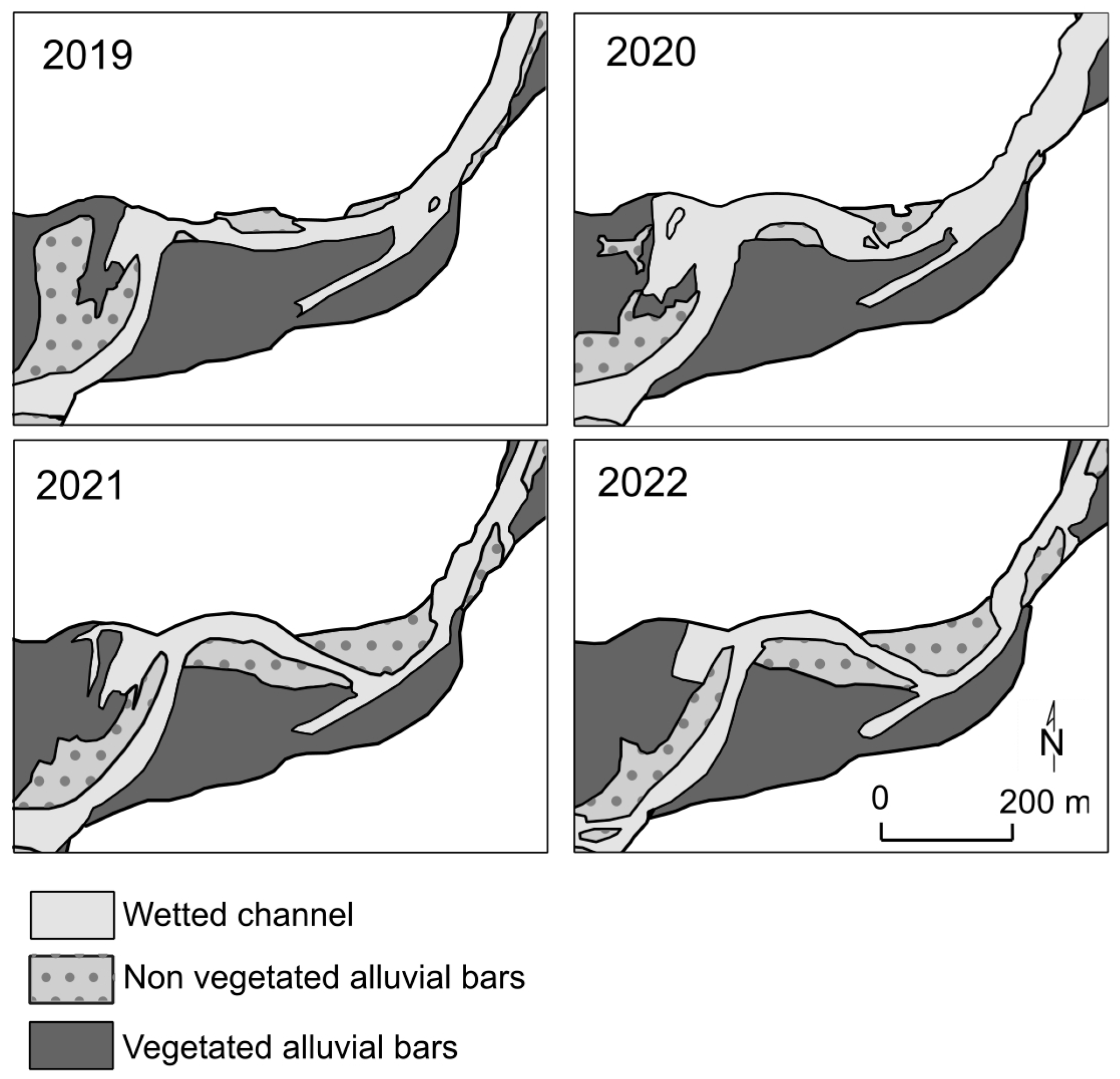
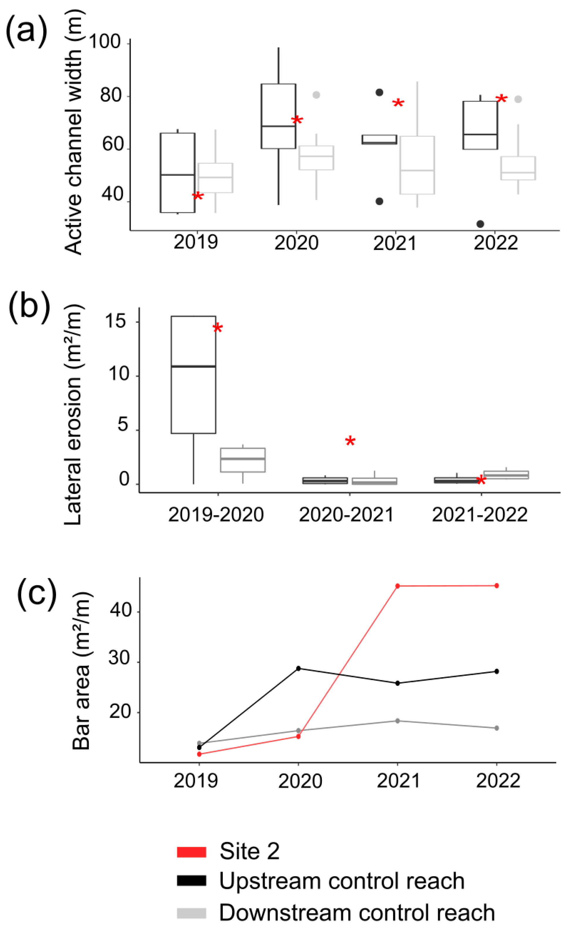
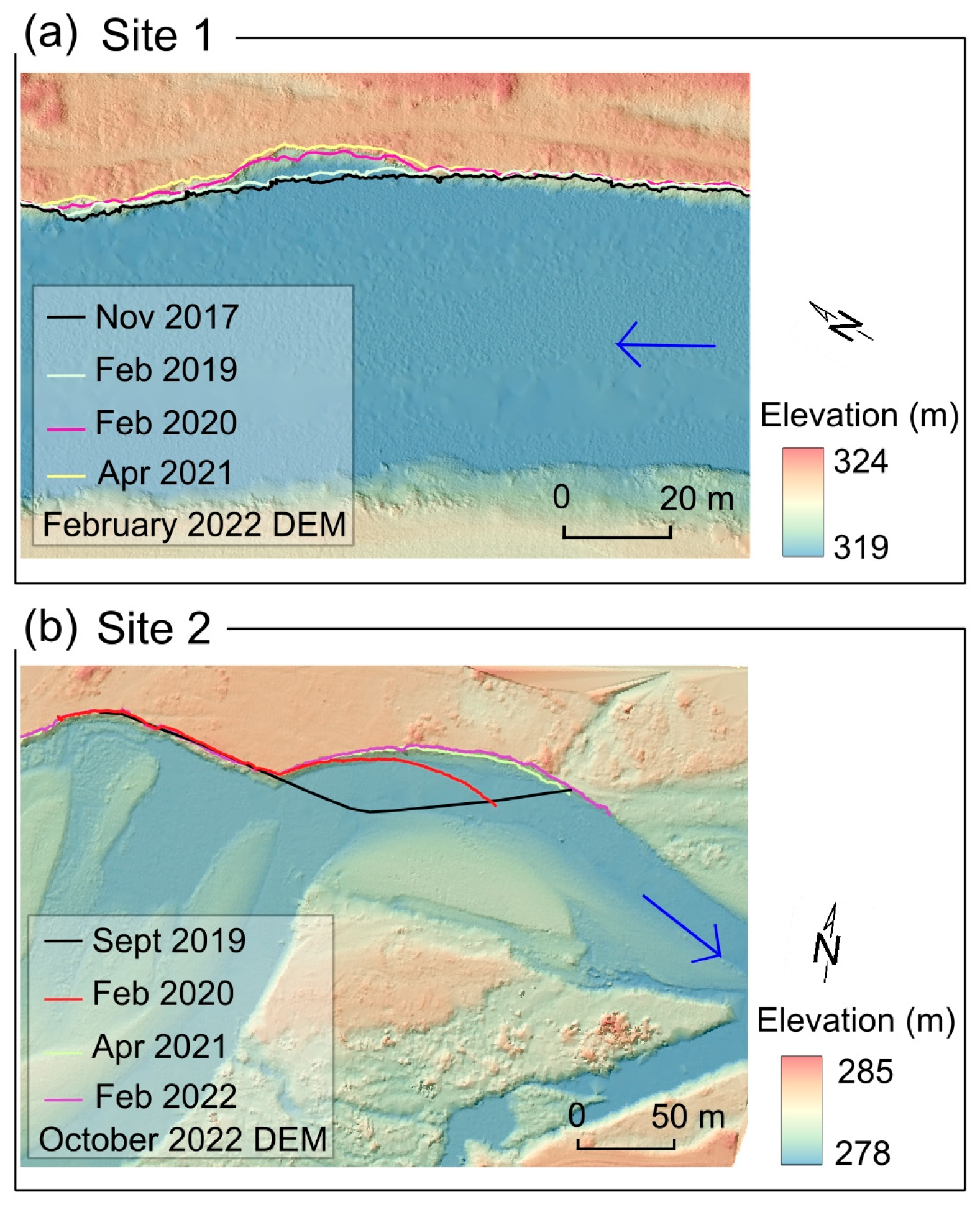
5.1. Monitoring of Bank Erosion Using Photogrammetry and LiDAR

At Site 1, between November 2017 and February 2022, an erosion notch formed in the middle of the bank, mainly during the P2B period (February 2019–February 2020; Figure 4a). The sediment balances of the emerged surfaces of the bank were −418 m3 for P1B, −447 m3 for P2B, −345 m3 for P3B, and −96 m3 for P4B.
At Site 2, the downstream half of the newly restored bank showed significant changes (Figure 4b). For the latter part, the first period P1C (September 2019–February 2020) recorded the most important bank retreat, with a maximum bank retreat of 28 m. This eroded area corresponded to an erosion volume of 6086 m3 for emerged parts of the bank, and the estimated total eroded volume was 9647 m3. During the second period P2C (February 2020–April 2021), the eroded area was mainly located on the downstream part of the active bank, with a maximum width retreat of 21 m and an eroded volume of 3149 m3 for the emerged parts of the bank. The estimated total eroded volume for P2C was 6152 m3.
During the third (P3C; April 2021–February 2022) and fourth (P4C; February 2022–October 2022) periods, changes were minor (Figure 4 and Figure 5). During the third period (P3C), 754 m3 of sediments were eroded from the bank, preferentially located downstream from the apex of the bank, whereas the point bar gained 178 m3 of sediment accretion. Erosion of the point bar was preferentially located at the bar head, and deposition occurred in the chute channel and on the bar tail near the main channel. During the fourth period (P4C), the erosion/deposition processes were insignificant, with a sediment balance of −78 m3 on the bank and +48 m3 on the point bar.

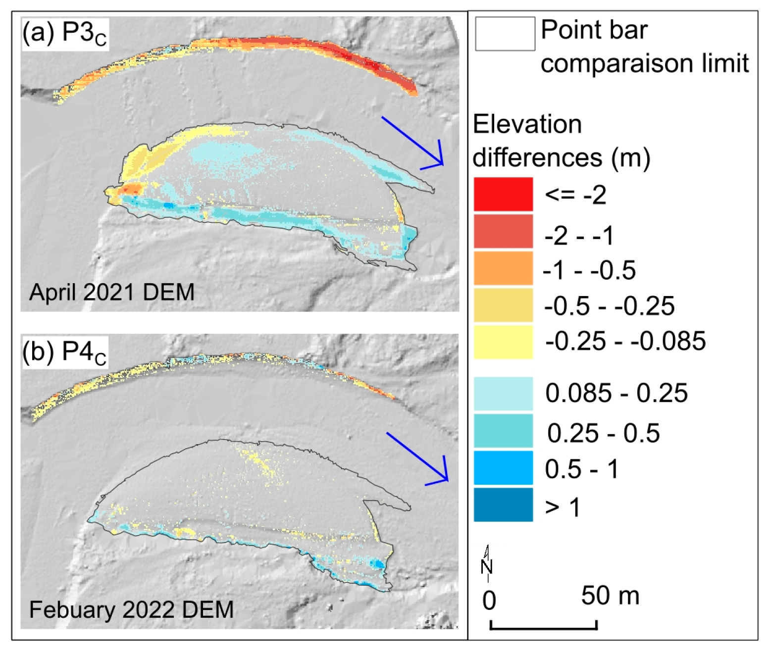
5.2. Morphological Channel Change Analysis

At the Site 1 bank, despite a monitoring period of five years, the recorded erosion rates were so low and insignificant that no further analysis was carried out. Conversely, at Site 2, the bank erosion rates were significant within the three-year period after riprap removal. The initial state of the channel before the removal of the riprap was mapped for 2019 (Figure 6). The growth of the point bar and downstream bar occurred concomitantly with bank retreat. The sinuosity index increased from 1.43 in 2019 to 1.46 in 2022. On the basis of the width of the active channel each year, the water slope in 2020, and the Q2 discharge, the specific stream power decreased from 135 W/m2 in 2019 to 82 W/m2 in 2020 and to 78 W/m2 in 2021 and 2022.
In comparison to the two control reaches, Site 2 showed a singular behaviour of active channel evolution (Figure 7). After the reactivation of bank erosion between 2019 and 2020, the active channel width at Site 2 continued to widen, which was marked by significant bank erosion and important sediment deposition on bars between 2020 and 2021.
Between 22 November 2021 and 11 August 2022, bathymetric surveys recorded vertical and lateral morphological channel changes (Figure 8). At the two upstream cross-sections, no changes in the bank position were recorded, which contrasted with the main channel where the erosion process dominated, with an erosion area of 26 m2 on the first cross-section (t1) and an erosion area of 15 m2 on the second cross-section (t2). The two downstream cross-sections (t3 and t4) recorded bank retreats of −12 m2 and −19 m2, respectively. At t4, where in-channel accumulation dominated, bank erosion caused an overall difference of −10 m2.

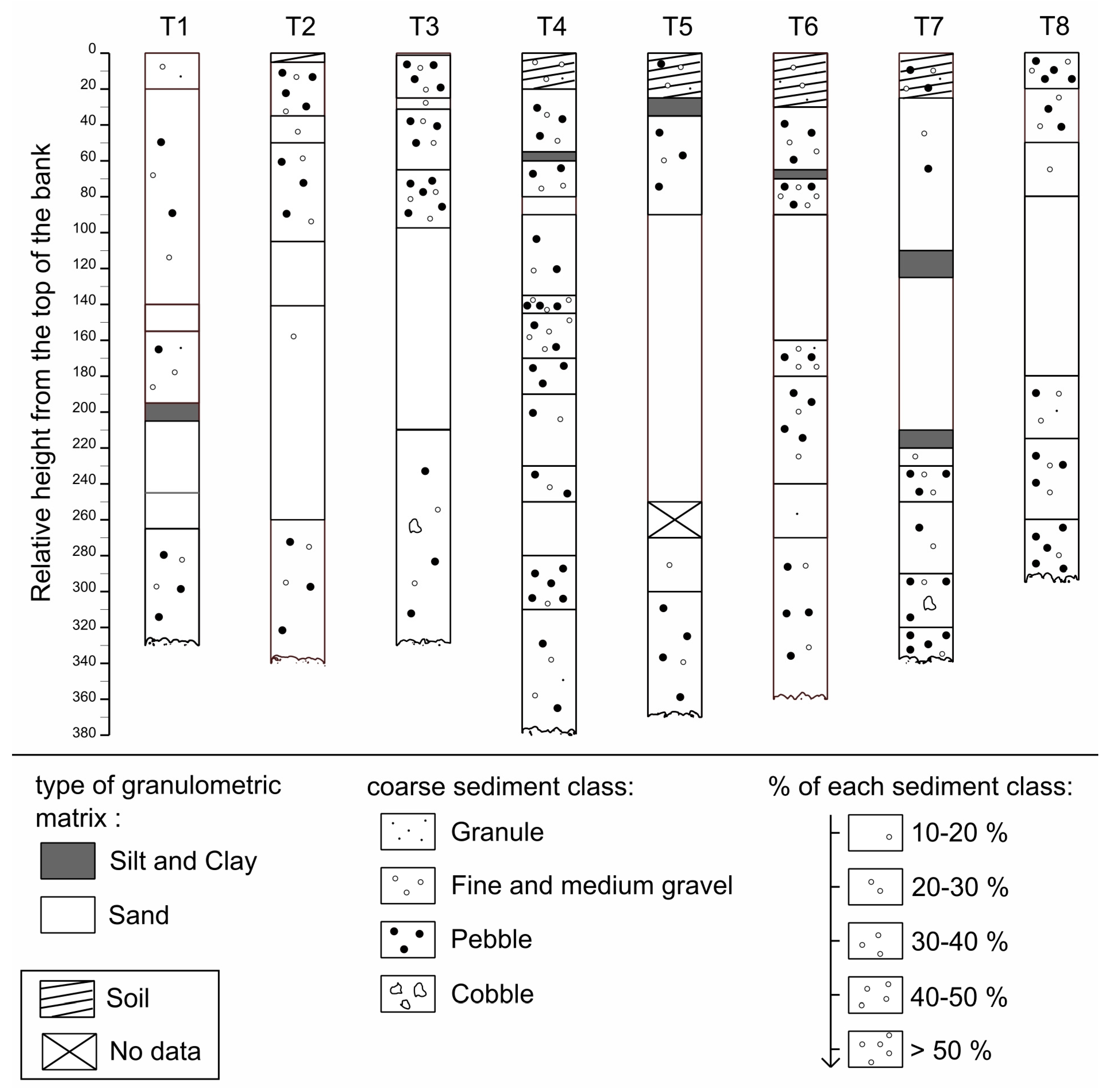
5.3. Grain Size Analysis

The bank was composed of 45% sand and 51% gravel (Figure 9). Small cobbles represented 4% of the total composition of the bank. Some discontinuous and thin silty and clayey layers were found. From this grain size analysis, the estimated volumes of sand eroded and reinjected into the channel were 4312 m3 for P1C and 2750 m3 for P2C. The amounts of gravel reinjected were estimated to be 4918 m3 for P1C and 3137 m3 for P2C. The amounts of small cobble reinjected were estimated to be 397 m3 for P1C and 253 m3 for P2C.
The surface granulometric sampling showed a D50 ranging between 30 mm (head of the bar) and 57 mm (downstream riffle) and a D84 between 48 mm (head of the bar) and 90 mm (downstream riffle).

6. Discussion

In industrial countries since the 1970s and 1980s, there has been widespread recognition of the need to restore river functioning and fluvial ecosystem processes following their severe degradation, which was especially common during the 20th century as a result of intense human impact and river training works [44,45,46,47,48,49]. A compromise must be found between the natural functioning of rivers and the benefits that societies derive from their exploitation [29]. In this context, process-based restoration approaches appear to be more sustainable than form-based restoration because they aim to restore dynamic and resilient functioning [14,17,29]. Among process-based restorations, the concept of freedom space for rivers defines a minimum space in which river processes can be preserved and, if necessary, restored [5,8,12,13,28].

6.1. Contrasting Responses of Bank Erosion after Riprap Removal between Site 1 and Site 2

The eroded volumes at each site, five and three years after the removal of the bank protections at Sites 1 and 2, respectively, revealed two significantly contrasting situations. At Site 1, where the riprap was removed at the end of summer 2017, little bank erosion occurred. Between 2017 and 2022, only a small notch was created in the middle part of the restored bank, following a flood with a return period of 2 years (November 2019), and, one month later (December 2019), a flood of lower magnitude (P2B; Figure 4). In contrast, the same two floods caused significant bank retreat at Site 2, corresponding to a volume of 9647 m3 of eroded sediment (P1C). In addition, at Site 2, another 6152 m3 was eroded from the restored bank during the following study period (P2C), caused by another 2-year flood (June 2020) followed eight months later (February 2021) by a lower magnitude flood. In total, at Site 2, almost 16,000 m3 of sediment was eroded and reinjected into the channel during the first two monitoring periods (P1C and P2C). For these two periods, the recorded erosion was 14 times and 10 times more important, respectively, at Site 2 than at Site 1 (for emerged surfaces), attesting to two contrasting site characteristics.
The primary factors controlling bank erosion are parameters comprising bank geometry (height and slope), bank material properties (grain size and porosity), and vegetation (roots, weight, and soil moisture modification) [50,51,52,53,54]. The restored bank at Site 2 was mainly composed of coarse sediments, i.e., sand and gravel, with only a few thin layers of fine cohesive sediments (Figure 9). The lack of cohesive sediment layers leads to high bank erosion potential because the undermining of the bank toe is not hindered by any cohesive slump blocks. This was different in the case of Site 1, where auger analyses carried out during the feasibility study by CEN Auvergne revealed a cohesive layer of variable depth (between 30 and 150 cm) composed of silts [36]. The presence of this layer, once destabilised through bank failures and the formation of slump blocks at the toe of the bank, will temporarily protect it from bank undercutting and consequently decrease lateral channel erosion rates [55,56]. Beyond the shear stress necessary for the movement of cohesive slump blocks, they also alter the shear stress near the bank [57,58]. Furthermore, the apparent cohesion at the substrate–slump block interface may delay the incipient motion of these cohesive slump blocks [59]. Another determining factor in the decrease in bank undercutting is the presence of marl [36]. The presence of marl bedrock at the base of the bank can strongly reduce bank undercutting due to its higher mechanical resistance to erosion than alluvium. This low erodibility potential at Site 1 was reinforced by two additional factors. First, the presence of abundant ligneous vegetation covering the bank slope increased the roughness and bank cohesion by the root network [60]. Second, the presence of rubble within the bank and the presence of immobile blocks, depending on their size but also on their prevalence, also contributed to the bank’s resistance to bank erosion [61].
In addition to these intrinsic bank erodibility factors, bank erosion is guided by the local geomorphological context, which was more conducive to bank erosion at Site 2 than at Site 1. First, the restored bank at Site 2 was more exposed to direct flow than was the restored bank at Site 1, which was positioned at the apex of a low sinuosity (Figure 1). Second, the planform geometry at Site 2 certainly promoted undercutting of the concave restored bank through the formation of helicoidal flow hydraulics and secondary flows that favoured lateral accretion processes on the point bar within the convex bank of the meander (bar push) [62] (Figure 5, Figure 6 and Figure 8). The intensity of transport rates encourages the bar push phenomenon, and thus, it plays an important role in meander migration. The higher the transport rates are, the higher the meander migration rates are [63,64,65]. In contrast, at Site 1, the significant sediment deficit, shown by the very scarce sediment cover on the marl outcrops, did not favour the reactivation of bank erosion.

6.2. Potential Replenishment of Bedload after Riprap Removal

The recovery of bank erosion after riprap removal is a condition for the success of the second restoration objective, which is to increase local sediment supply and, thus, to contribute to slowing down the rate of channel incision or even counteracting it. In light of the lack of bank erosion at Site 1, it can be concluded that bank protection removal does not necessarily signify sediment replenishment. However, at Site 2 and despite exposure to the same flood events as Site 1, the local replenishment of bedload was made evident through channel morphology readjustments that occurred during bank erosion. Bank erosion has led to the widening of the channel from 43 m (2019) to 79 m (2022). With the widening of the channel, the local specific stream power decreased by almost 40% after the first period (P1C) and by 9% after the second period (P2C). However, these estimates should be treated with caution because they do not consider slope adjustments in relation to channel widening. Channel widening is a key factor in slowing or stopping channel incision. On the restored section of the Mur River, Austria, where post-restoration channel widening occurred due to bank erosion, shear stress significantly decreased [21]. On the Upper Drau River, Austria, the widening of the channel allowed the incision to be stopped and counterbalanced by an aggradation of the bed [66]. At Site 2, even though readjustment favoured a local decrease in channel incision, only longer-term field campaigns will be able to confirm these preliminary results. In particular, longer-term topobathymetric monitoring will be necessary to survey vertical channel bed evolution.
Grain size analyses showed that the bank sediment reservoir offers good potential for sediment in-channel recharge. At least half of the bank sediments were composed of gravel (51%) and, to a lesser extent, cobble (4%). For period P1C, 4918 m3 of gravel and 397 m3 of cobble were reinjected into the channel, and for period P2C, 3137 m3 of gravel and 253 m3 of cobble were reinjected into the channel. However, based on only these volumes, it is difficult to predict what the future eroded volumes and contributions to sediment refill will be over the long term. The high erosion rates recorded over periods P1C and P2C were due to channel readjustments (Figure 7). Once the channel is morphologically readjusted, lower erosion rates than those recorded during the first and second periods are expected for similar flood patterns. Only when this equilibrium stage is reached can the estimate of lateral input from bank erosion be fully calculated.
For the P3C period, a negative sediment balance between the eroded bank and the opposite point bar was observed, which indicates that some of the eroded bank sediment was transported downstream beyond the meander. The pathways and distances of sediments eroded from the bank and transported downstream are an important issue in post-restoration monitoring to better evaluate sediment trapping on the bar and potential transport downstream. For this purpose, in March 2021, sixty natural pebbles, consisting mostly of granite or basalt, according to the petrography of the Allier River, were equipped with active radio frequency identification (RFID) tags to monitor the individual movement of eroded particles from the restored bank [24,67,68,69]. They were distributed in ten equidistant, i.e., 15 m, profiles along the bank. On each profile, six pebbles were equipped and inserted into the bank (10/20 cm inside the bank), distributed every 50 cm from top to bottom. A first survey in August 2022 showed that no bank erosion took place since the injection of the equipped pebbles into the riverbank.

6.3. Lessons to Be Learned from Process-Based Bank Restoration

The application of a freedom space by removing riprap must consider two sets of criteria: (1) the level of the urban and human pressures in the floodplain and (2) the capacity of the river to erode [27]. The level of urban and human pressure is the first factor concerning the establishment of a freedom space. It should also be noted that in the case where the implementation of a freedom space does not conflict with human issues, it may still be questioned by local stakeholders. The acceptability of such a restoration measure can be achieved only through a good understanding of the river system and interest in restoring river systems [29,30]. The different criteria to be considered in the assessment of the second point, i.e., the capacity of the river to start eroding its banks again, are the degree of erodibility of the bank and the morphodynamic context. In accordance with observations at Site 1 on the river Allier, the reactivation of lateral channel erosion in a reach of the Old Rhine (France/Germany) was incomplete due to intrinsic bank parameters, such as the possibility that old bank protection underlying the removed bank still exists, the presence of bedrock outcrops at the toe of the bank, and the protective role of vegetation [24]. However, even if the erodibility parameters of the bank favour the restoration of lateral channel erosion, sediment supply and its balance with the transport capacity play an important role.
Flume experiments have shown that a low sediment supply does not favour channel widening [70]. Additionally, in the case of the Upper Drau, the authors point out that channel aggradation after widening was possible only because of the upstream sediment supply, not only the local supply [66]. Consequently, for reaches such as Site 1, more interventionist measures may have to be considered to further initiate lateral channel dynamics. Indeed, to initiate the re-establishment of bank erosion, other restoration projects should accompany the removal of riprap with complementary measures, such as the artificial addition of coarse sediment to the channel and/or the installation of groynes, which, by modifying flow hydraulics close to the bank, may increase lateral erosion [21,25]. The combination of riprap removal and the artificial reinjection of gravel into the channel, the latter, however, being expensive, is another option highlighted considering some sections of the Cher River, France, another tributary of the Loire, where the potential to restore lateral channel erosion is restricted due to the limited sediment supply and the low coarse sediment transport rates [71]. However, even with the restoration of sediment transport in sediment-deficient reaches, the reactivation of lateral erosion may take several years or even decades in contrast to a dynamic reach fed by a high sediment supply [70].
In addition to the sedimentary and geomorphological characteristics of the bank, the reactivation of lateral erosion is controlled by the flood regime. In the case of the two restorations on the middle Allier River, the time elapsed between the restoration works and the first morphogenic flood influenced the effectiveness of subsequent floods. At Site 1, no hydrologic event greater than or equivalent to a 2-year flood occurred after riprap removal in September 2017, which promoted the re-sprouting of stumps left in place (Figure 2). In contrast, this time lapse between riprap removal and efficient hydrologic conditions was only two months at Site 2. Consequently, the remaining stumps did not have time to re-sprout and were washed away during the first period. This clearly favoured subsequent bank erosion on Site 2 in comparison to Site 1 where the stumps remained and re-sprouted, in addition to the low cohesiveness of the sediment and the channel planform at Site 2. Additionally, it should be noted that these floods, allowing for a reactivation of bank erosion on Site 2, were below the most efficient discharge for sediment erosion and transport, corresponding to the bankfull discharge [72,73,74]. Despite its low magnitude, this allowed the reactivation of bank erosion at Site 2; however, for Site 1, which presents a strong sediment deficit, floods close to the bankfull discharge do not allow significant morphological activity in the channel, unlike higher magnitude and lower recurrence floods [70]. The hydrological situation encountered during this study period reflects the hydrological change that has taken place since the second half of the 20th century on the middle Allier River, with a decrease in the frequency, duration, and intensity of floods and, on the contrary, an increase in the duration of low-water periods [33]. Research carried out on the hydrological evolution of the Loire catchment in relation to climate change highlighted a decline in the average annual flows and low water flows as well as an increase in the duration of low water flows. However, hydrological forecasts remain more uncertain regarding the flood regime [75,76]. These changes in the hydrological regime in the coming years are an important issue, affecting the evolution of the functioning of rivers and consequently the management and restoration plans applied to them. Nevertheless, as illustrated by the two examples of restoration on the Allier River, considering the evolution of the hydrological regime in the application of a freedom space is, therefore, necessary to set up efficient and sustainable restoration [13].

7. Conclusions

Since the 1970s, the restoration of rivers, including their in-channel habitats and floodplains, has remained an important issue because they are hotspots of biodiversity and provide many ecosystem services to society. However, the restoration of these processes, particularly in the case of the most degraded reaches, remains a major additional challenge in the context of current climate and global change. Within the framework of the freedom space for rivers, on the middle Allier River, two stretches of riprap were removed to allow self-restoration of its lateral channel dynamics. The contrasting effectiveness of the restoration measure at the two sites was mainly explained by differences in particle size composition and the cohesiveness of the banks strengthened by the presence of ligneous vegetation, with all factors controlling bank erodibility. Channel morphology and planform geometry, which determine flow directions and effective tractive forces applied on the banks during high flows, also have to be considered. In addition, sediment supply and the presence of a point bar promote lateral erosion and its downstream migration. In conclusion, this study improves the understanding of hydrogeomorphological restoration processes and control factors, allowing managers to target future restoration sites and to measure the actual impacts of restoration. However, further case studies and long-term post-restoration monitoring, including surveys of pebbles equipped with RFID tracers injected into the restored banks, are needed to improve knowledge of these restoration measures. Furthermore, the effectiveness of this restoration measure remains dependent on the hydrological regime of the target site, the future evolution of which is largely uncertain in response to climate change.

Author Contributions

Conceptualization, A.A., J.S. (Johannes Steiger), E.G., S.P., E.R. and J.S. (Julien Saillard); formal analysis, A.A., S.P. and F.V.; funding acquisition, J.S. (Johannes Steiger), E.R. and F.V.; investigation, A.A., J.S. (Johannes Steiger), S.P., E.R., F.V. and O.V.; methodology, A.A., E.G., S.P., E.R., J.S. (Julien Saillard), F.V. and O.V.; project administration, J.S. (Johannes Steiger); supervision, J.S. (Johannes Steiger), E.G. and E.R.; writing—original draft, A.A., J.S. (Johannes Steiger), E.G., S.P., E.R., F.V., O.V. and J.S. (Julien Saillard). All authors have read and agreed to the published version of the manuscript.

Funding

The Auvergne-Rhône-Alpes Region financed the research project “RALLIER—Water Resources, Agriculture and Alluvial Forest: Incision and Degradation of the Allier River”. We also acknowledge additional financial support by the Agence de l’eau Loire-Bretagne, the Établissement Public Loire, the SAGE Allier Aval, the University Clermont Auvergne CAP20-25, and LTSER Zone Atelier Loire—CNRS. The PhD thesis of the first author was financed through the project RALLIER.

Institutional Review Board Statement

Not applicable.

Informed Consent Statement

Not applicable.

Data Availability Statement

The data presented in this study are openly available in Data.InDoRES at https://doi.org/10.48579/PRO/PFZLAQ.

Acknowledgments

We would like to thank the two trainees, C. Laborie and M. Keles, who helped us with the collection and processing of the particle size data. We also thank the two reviewers for their comments and suggestions.

Conflicts of Interest

The authors declare no conflict of interest. The funders had no role in the design of the study; in the collection, analyses, or interpretation of data; in the writing of the manuscript; in the decision to publish the results.

References

  1. Schumm, S.A. The Fluvial System; Wiley: New York, NY, USA, 1977; p. 338. [Google Scholar]
  2. Amoros, C.; Petts, G.E. Fluvial Hydrosystems; Chapman & Hall: London, UK, 1996; p. 336. [Google Scholar]
  3. Florsheim, J.L.; Mount, J.F.; Chin, A. Bank erosion as a desirable attribute of rivers. BioScience 2008, 58, 519–529. [Google Scholar] [CrossRef] [Green Version]
  4. Petts, G.E.; Möller, H.; Roux, A.L. Historical Change of Large Alluvial Rivers: Western Europe; J. Wiley & Sons: Chichester, UK, 1989; p. 355. [Google Scholar]
  5. Ollero, A. Channel changes and floodplain management in the meandering middle Ebro River, Spain. Geomorphology 2010, 117, 247–260. [Google Scholar] [CrossRef]
  6. Dépret, T.; Gautier, E.; Hooke, J.; Grancher, D.; Virmoux, C.; Brunstein, D. Causes of planform stability of a low-energy meandering gravel-bed river (Cher River, France). Geomorphology 2017, 285, 58–81. [Google Scholar] [CrossRef]
  7. Reid, D.; Church, M. Geomorphic and ecological consequences of riprap placement in river systems. J. Am. Water Resour. Assoc. 2015, 51, 1043–1059. [Google Scholar] [CrossRef]
  8. Piégay, H.; Darby, S.E.; Mosselman, E.; Surian, N. A review of techniques available for delimiting the erodible river corridor: A sustainable approach to managing bank erosion. River Res. Appl. 2005, 21, 773–789. [Google Scholar] [CrossRef]
  9. Piégay, H.; Barge, O.; Landon, N. Streamway concept applied to river mobility/human use conflict management. In Rivertech: Proceeding of Rivertech ‘96: First International Conference on New/Emerging Concepts for Rivers; Maxwell, W.H.C., Preul, H., Stout, G.E., Eds.; International Water Resources Association: Chicago, IL, USA, 1996; pp. 681–688. [Google Scholar]
  10. Piégay, H.; Cuaz, M.; Javelle, E.; Mandier, P. Bank erosion management based on geomorphological, ecological and economic criteria on the Galaure River, France. Regul. Rivers Res. Manag. 1997, 13, 433–448. [Google Scholar] [CrossRef]
  11. Malavoi, J.R.; Bravard, J.P.; Piégay, H.; Hérouin, E.; Ramez, P. Guide Technique n°2. Détermination de L’espace de Liberté des Cours D’eau; Agence de l’eau: Lyon, France, 1998; p. 39. [Google Scholar]
  12. Biron, P.M.; Buffin-Bélanger, T.; Larocque, M.; Choné, G.; Cloutier, C.-A.; Ouellet, M.-A.; Demers, S.; Olsen, T.; Desjarlais, C.; Eyquem, J. Freedom space for rivers: A sustainable management approach to enhance river resilience. Environ. Manag. 2014, 54, 1056–1073. [Google Scholar] [CrossRef] [Green Version]
  13. Buffin-Bélanger, T.; Biron, P.M.; Larocque, M.; Demers, S.; Olsen, T.; Choné, G.; Ouellet, M.-A.; Cloutier, C.-A.; Desjarlais, C.; Eyquem, J. Freedom space for rivers: An economically viable river management concept in a changing climate. Geomorphology 2015, 251, 137–148. [Google Scholar] [CrossRef]
  14. Palmer, M.A.; Bernhardt, E.S.; Allan, J.D.; Lake, P.S.; Alexander, G.; Brooks, S.; Carr, J.; Clayton, S.; Dahm, C.N.; Shah, J.F.; et al. Standards for ecologically successful river restoration: Ecological success in river restoration. J. Appl. Ecol. 2005, 42, 208–217. [Google Scholar] [CrossRef]
  15. England, J.; Skinner, K.S.; Carter, M.G. Monitoring river restoration and the Water Framework Directive. Water Environ. J. 2008, 22, 227–234. [Google Scholar] [CrossRef]
  16. Dufour, S.; Piégay, H. From the myth of a lost paradise to targeted river restoration: Forget natural references and focus on human benefits. River Res. Appl. 2009, 25, 568–581. [Google Scholar] [CrossRef]
  17. Beechie, T.J.; Sear, D.A.; Olden, J.D.; Pess, G.R.; Buffington, J.M.; Moir, H.; Roni, P.; Pollock, M.M. Process-based principles for restoring river ecosystems. BioScience 2010, 60, 209–222. [Google Scholar] [CrossRef] [Green Version]
  18. Wohl, E.; Lane, S.N.; Wilcox, A.C. The science and practice of river restoration. Water Resour. Res. 2015, 51, 5974–5997. [Google Scholar] [CrossRef] [Green Version]
  19. Jähnig, S.C.; Brunzel, S.; Gacek, S.; Lorenz, A.W.; Hering, D. Effects of re-braiding measures on hydromorphology, floodplain vegetation, ground beetles and benthic invertebrates in mountain rivers. J. Appl. Ecol. 2009, 46, 406–416. [Google Scholar] [CrossRef]
  20. Januschke, K.; Jähnig, S.C.; Lorenz, A.W.; Hering, D. Mountain river restoration measures and their success(ion): Effects on river morphology, local species pool, and functional composition of three organism groups. Ecol. Indic. 2014, 38, 243–255. [Google Scholar] [CrossRef]
  21. Klösch, M.; Hornich, R.; Baumann, N.; Puchner, G.; Habersack, H. Mitigating channel incision via sediment input and self-initiated riverbank erosion at the Mur river, Austria. In Stream Restoration in Dynamic Fluvial Systems: Scientific Approaches, Analyses, and Tools; Simon, A., Bennett, S.J., Castro, J.M., Eds.; American Geophysical Union: Washington, DC, USA, 2011; pp. 319–336. [Google Scholar]
  22. Duró, G.; Crosato, A.; Kleinhans, M.G.; Roelvink, D.; Uijttewaal, W.S.J. Bank erosion processes in regulated navigable rivers. J. Geophys. Res. Earth Surf. 2020, 125, e2019JF005441. [Google Scholar] [CrossRef]
  23. Staentzel, C.; Combroux, I.; Barillier, A.; Grac, C.; Chanez, E.; Beisel, J.-N. Effects of a river restoration project along the Old Rhine River (France-Germany): Response of macroinvertebrate communities. Ecol. Eng. 2019, 127, 114–124. [Google Scholar] [CrossRef]
  24. Chardon, V.; Schmitt, L.; Clutier, A. Bank re-erosion action to promote sediment supply and channel diversification: Feedback from a restoration test on the Rhine. River Res. Appl. 2022, 38, 975–987. [Google Scholar] [CrossRef]
  25. Williams, R.D.; Bangen, S.; Gillies, E.; Kramer, N.; Moir, H.; Wheaton, J. Let the river erode! Enabling lateral migration increases geomorphic unit diversity. Sci. Total Environ. 2020, 715, 136817. [Google Scholar] [CrossRef]
  26. Seele-Dilbat, C.; Kretz, L.; Wirth, C. Vegetation of natural and stabilized riverbanks and early effects of removal of bank fixation. Int. Rev. Hydrobiol. 2022, 107, 88–99. [Google Scholar] [CrossRef]
  27. Kondolf, G.M. Setting Goals in River Restoration: When and where can the river “Heal itself”? In Stream Restoration in Dynamic Fluvial Systems: Scientific Approaches, Analyses, and Tools; Simon, A., Bennett, S.J., Castro, J.M., Eds.; American Geophysical Union: Washington, DC, USA, 2011; pp. 29–44. [Google Scholar]
  28. Kondolf, G.M. The Espace de liberté and restoration of fluvial process: When can the river restore itself and when must we intervene? In River Conservation and Management; Boon, P.J., Raven, P.J., Eds.; Wiley-Blackwell: Chichester, UK, 2012; pp. 223–241. [Google Scholar]
  29. Corenblit, D.; Fort, M.; Arnaud-Fassetta, G.; Melun, G.; Dousseau, J.; Uemura, Y.; Steiger, J. Toward a functional compromise between society and Mediterranean fluvial hydrosystems in France? In European Continental Hydrosystems Under Changing Water Policy; Arnaud-Fassetta, G., Masson, E., Reynard, E., Eds.; Friedrich Pfeil Verlag: Munich, Germany, 2013; pp. 27–36. [Google Scholar]
  30. Steiger, J.; Corenblit, D.; Carozza, J.-M.; Dejaifve, P.-A.; Delmotte, S.; Ejarque, A.; Sans, L.F.; Simon, P.; Tabacchi, E.; Valette, P.; et al. Rapport d’activité du projet GALE&T « Garonne et Allier Eaux & Territoires » du programme national « Eaux & Territoires », Ministère de l’Écologie; Unpublished Report; CNRS-INEE; IRSTEA: Paris, France, 2014. [Google Scholar]
  31. Merle, O.; Michon, L. The formation of the West European Rift: A new model as exemplified by the Massif Central area. Bull. Société Géologique Fr. 2001, 172, 213–221. [Google Scholar] [CrossRef] [Green Version]
  32. Onde, H. Les crues de l’Allier. Rev. Géographie Alp. 1923, 11, 301–372. [Google Scholar] [CrossRef]
  33. Arfeuillère, A.; Steiger, J.; Roussel, E.; Petit, S.; Neel, C.; Gautier, E. Statistical approach of contemporary hydrogeomorphological channel changes of the middle Allier River, France: Morphostructural controls, human impacts and flow regime. Géomorphologie Relief Process. Environ. 2022; in press. [Google Scholar]
  34. DIREN Auvergne. Etude de l’Allier entre Vieille-Brioude et Villeneuve; Agence de l’eau: Lyon, France, 1998; p. 135. [Google Scholar]
  35. Bazin, P.; Gautier, E. Un espace de liberté pour la Loire et l’Allier: De la détermination géomorphologique à la gestion. Rev. Géographie Lyon 1996, 71, 377–386. [Google Scholar] [CrossRef]
  36. Saillard, J. Etude de faisabilité de restauration de la dynamique latérale de l’Allier à Bellerive (La Roche Noire/Pérignat-ès-Allier); Conservatoire d’Espaces Naturels d’Auvergne: Mozac, France, 2016; p. 42. [Google Scholar]
  37. Saillard, J. Etude de faisabilité de restauration de la dynamique latérale de l’Allier sur l’Ile des Cailloux à Maringues; Conservatoire d’Espaces Naturels d’Auvergne: Mozac, France, 2018; p. 51. [Google Scholar]
  38. Westoby, M.J.; Brasington, J.; Glasser, N.F.; Hambrey, M.J.; Reynolds, J.M. ‘Structure-from-Motion’ photogrammetry: A low-cost, effective tool for geoscience applications. Geomorphology 2012, 179, 300–314. [Google Scholar] [CrossRef] [Green Version]
  39. Duró, G.; Crosato, A.; Kleinhans, M.G.; Uijttewaal, W.S.J. Bank erosion processes measured with UAV-SfM along complex banklines of a straight mid-sized river reach. Earth Surf. Dyn. 2018, 6, 933–953. [Google Scholar] [CrossRef] [Green Version]
  40. Brasington, J.; Langham, J.; Rumsby, B. Methodological sensitivity of morphometric estimates of coarse fluvial sediment transport. Geomorphology 2003, 53, 299–316. [Google Scholar] [CrossRef]
  41. Downward, S.R.; Gurnell, A.M.; Brookes, A. A methodology for quantifying river channel planform change using GIS. IAHS Publ. 1994, 224, 449–456. [Google Scholar]
  42. Riverbed {R} Package: Calculation of Surfaces and Volumes Based on Topological Profiles. Available online: https://github.com/lvaudor/riverbed (accessed on 19 January 2023).
  43. Wolman, M.G. A method of sampling coarse river-bed material. Eos Trans. Am. Geophys. Union 1954, 35, 951–956. [Google Scholar] [CrossRef] [Green Version]
  44. Steiger, J.; Corenblit, D.; Vervier, P. Les ajustements morphologiques contemporains du lit mineur de la Garonne, France et leurs effets sur l’hydrosystème fluvial. Ann. Géomorphologie/Ann. Geomorphol./Z. Für Geomorphol. 2000, 122, 227–246. [Google Scholar]
  45. Liébault, F.; Piégay, H. Causes of 20th century channel narrowing in mountain and piedmont rivers of southeastern France. Earth Surf. Process. Landf. 2002, 27, 425–444. [Google Scholar] [CrossRef]
  46. Surian, N.; Rinaldi, M. Morphological response to river engineering and management in alluvial channels in Italy. Geomorphology 2003, 50, 307–326. [Google Scholar] [CrossRef]
  47. Vericat, D.; Batalla, R.J. Sediment transport in a large impounded river: The lower Ebro, NE Iberian Peninsula. Geomorphology 2006, 79, 72–92. [Google Scholar] [CrossRef]
  48. Wyżga, B. A review on channel incision in the Polish Carpathian rivers during the 20th century. In Developments in Earth Surface Processes; Habersack, H., Piégay, H., Rinaldi, M., Eds.; Elsevier: Amsterdam, The Netherlands, 2007; Volume 11, pp. 525–553. [Google Scholar] [CrossRef]
  49. Salit, F.; Arnaud-Fassetta, G.; Zaharia, L.; Madelin, M.; Beltrando, G. The influence of river training on channel changes during the 20th century in the Lower Siret River (Romania). Géomorphologie Relief Process. Environ. 2015, 21, 175–188. [Google Scholar] [CrossRef]
  50. Lawler, D.M. The impact of scale on the processes of channel-side sediment supply: A conceptual model. IAHS Publ. 1995, 226, 175–184. [Google Scholar]
  51. Abernethy, B.; Rutherfurd, I.D. Does the weight of riparian trees destabilize riverbanks? Regul. Rivers Res. Manag. 2000, 16, 565–576. [Google Scholar] [CrossRef]
  52. Simon, A.; Collison, A.J.C. Quantifying the mechanical and hydrologic effects of riparian vegetation on streambank stability. Earth Surf. Process. Landf. 2002, 27, 527–546. [Google Scholar] [CrossRef]
  53. Rinaldi, M.; Casagli, N.; Dapporto, S.; Gargini, A. Monitoring and modelling of pore water pressure changes and riverbank stability during flow events. Earth Surf. Process. Landf. 2004, 29, 237–254. [Google Scholar] [CrossRef]
  54. Konsoer, K.M.; Rhoads, B.L.; Langendoen, E.J.; Best, J.L.; Ursic, M.E.; Abad, J.D.; Garcia, M.H. Spatial variability in bank resistance to erosion on a large meandering, mixed bedrock-alluvial river. Geomorphology 2016, 252, 80–97. [Google Scholar] [CrossRef]
  55. Thorne, C.R. Processes and mechanisms of river bank erosion. In Gravel Bed Rivers; Hey, R.D., Bathurst, J.C., Thorne, C.R., Eds.; Wiley: Chichester, UK, 1982; pp. 227–271. [Google Scholar]
  56. Motta, D.; Langendoen, E.J.; Abad, J.D.; García, M.H. Modification of meander migration by bank failures. J. Geophys. Res. Earth Surf. 2014, 119, 1026–1042. [Google Scholar] [CrossRef]
  57. Kean, J.W.; Smith, J.D. Form drag in rivers due to small-scale natural topographic features: 1. Regular sequences. J. Geophys. Res. Earth Surf. 2006, 111, F04009. [Google Scholar] [CrossRef] [Green Version]
  58. Kean, J.W.; Smith, J.D. Form drag in rivers due to small-scale natural topographic features: 2. Irregular sequences. J. Geophys. Res. Earth Surf. 2006, 111, F04010. [Google Scholar] [CrossRef] [Green Version]
  59. Wood, A.L.; Simon, A.; Downs, P.W.; Thorne, C.R. Bank-toe processes in incised channels: The role of apparent cohesion in the entrainment of failed bank materials. Hydrol. Process. 2001, 15, 39–61. [Google Scholar] [CrossRef]
  60. Polvi, L.E.; Wohl, E.; Merritt, D.M. Modeling the functional influence of vegetation type on streambank cohesion. Earth Surf. Process. Landf. 2014, 39, 1245–1258. [Google Scholar] [CrossRef]
  61. Shobe, C.M.; Turowski, J.M.; Nativ, R.; Glade, R.C.; Bennett, G.L.; Dini, B. The role of infrequently mobile boulders in modulating landscape evolution and geomorphic hazards. Earth-Sci. Rev. 2021, 220, 103717. [Google Scholar] [CrossRef]
  62. Dietrich, W.E.; Smith, J.D. Influence of the point bar on flow through curved channels. Water Resour. Res. 1983, 19, 1173–1192. [Google Scholar] [CrossRef]
  63. Constantine, J.A.; Dunne, T.; Ahmed, J.; Legleiter, C.; Lazarus, E.D. Sediment supply as a driver of river meandering and floodplain evolution in the Amazon Basin. Nat. Geosci. 2014, 7, 899–903. [Google Scholar] [CrossRef] [Green Version]
  64. Ahmed, J.; Constantine, J.A.; Dunne, T. The role of sediment supply in the adjustment of channel sinuosity across the Amazon Basin. Geology 2019, 47, 807–810. [Google Scholar] [CrossRef] [Green Version]
  65. Donovan, M.; Belmont, P.; Sylvester, Z. Evaluating the relationship between meander-bend curvature, sediment supply, and migration rates. J. Geophys. Res. Earth Surf. 2021, 126, e2020JF006058. [Google Scholar] [CrossRef]
  66. Habersack, H.; Piégay, H. River restoration in the Alps and their surroundings: Past experience and future challenges. In Developments in Earth Surface Processes; Habersack, H., Piégay, H., Rinaldi, M., Eds.; Elsevier: Amsterdam, The Netherlands, 2007; Volume 11, pp. 703–735. [Google Scholar]
  67. Lamarre, H.; MacVicar, B.; Roy, A. Using passive integrated transponder (PIT) tags to investigate sediment transport in gravel-bed rivers. J. Sediment. Res. 2005, 75, 736–741. [Google Scholar] [CrossRef]
  68. Arnaud, F.; Piégay, H.; Béal, D.; Collery, P.; Vaudor, L.; Rollet, A.J. Monitoring gravel augmentation in a large regulated river and implications for process-based restoration. Earth Surf. Process. Landf. 2017, 42, 2147–2166. [Google Scholar] [CrossRef]
  69. Cassel, M.; Dépret, T.; Piégay, H. Assessment of a new solution for tracking pebbles in rivers based on active RFID. Earth Surf. Process. Landf. 2017, 42, 1938–1951. [Google Scholar] [CrossRef]
  70. Rachelly, C.; Vetsch, D.F.; Boes, R.M.; Weitbrecht, V. Sediment supply control on morphodynamic processes in gravel-bed river widenings. Earth Surf. Process. Landf. 2022, 47, 3415–3434. [Google Scholar] [CrossRef]
  71. Dépret, T.; Thommeret, N.; Piégay, H.; Gautier, E. Can lateral mobility be restored along a highly domesticated low-energy gravel-bed river? J. Environ. Manag. 2023, 325, 116485. [Google Scholar] [CrossRef] [PubMed]
  72. Wolman, M.G.; Miller, J.P. Magnitude and frequency of forces in geomorphic processes. J. Geol. 1960, 68, 54–74. [Google Scholar] [CrossRef] [Green Version]
  73. Andrews, E.D. Effective and bankfull discharges of streams in the Yampa River basin, Colorado and Wyoming. J. Hydrol. 1980, 46, 311–330. [Google Scholar] [CrossRef]
  74. Torizzo, M.; Pitlick, J. Magnitude-frequency of bed load transport in mountain streams in Colorado. J. Hydrol. 2004, 290, 137–151. [Google Scholar] [CrossRef]
  75. Moatar, F.; Ducharne, A.; Thiéry, D.; Bustillo, V.; Sauquet, E.; Vidal, J.-P. La Loire à l’épreuve du changement climatique. Géosciences 2010, 12, 78–87. [Google Scholar]
  76. Chauveau, M.; Chazot, S.; Perrin, C.; Bourgin, P.Y.; Sauquet, E.; Vidal, J.P.; Rouchy, N.; Martin, E.; David, J.; Norotte, T.; et al. Quels impacts des changements climatiques sur les eaux de surface en France à l’horizon 2070? La Houille Blanche 2013, 4, 5–15. [Google Scholar] [CrossRef] [Green Version]
Figure 1. (a) Allier River catchment and location of the study sites and associated hydrological gauging stations. (b) Site 1. (c) Site 2. Map background: 2019 orthophotography produced by IGN.
Applsci 13 02981 g001
Figure 2. Daily mean discharges of the Allier River at the Vic-le-Comte gauging station (Site 1) between September 2017 and October 2022 in the top graph (“https://hydro.eaufrance.fr (accessed on 15 February 2023)”). Daily mean discharges at the Limons gauging station (Site 2) between September 2019 and October 2022 in the bottom graph (“https://hydro.eaufrance.fr (accessed on 15 February 2023)”). The calendar of the different surveys carried out is represented by coloured dots. The hydrological series is divided into four periods (from P1B to P4B for Site 1 and from P1C to P4C for Site 2) according to the date of the LiDAR surveys. See the Methods section for the different methods employed.
Applsci 13 02981 g002
Figure 3. (a) Location of the two control reaches. (b) Upstream control reach. (c) Downstream control reach. Map background: 2019 orthophotography produced by IGN.
Applsci 13 02981 g003
Figure 4. (a) Bank retreat at Site 1. November 2017: 2 months after work; February 2019: 17 months after work; February 2020: 29 months after work; April 2021: 43 months after work; February 2022: 53 months after work. (b) Bank retreat at Site 2. September 2019: 0 months after work; February 2020: 5 months after work; April 2021: 19 months after work; February 2022: 29 months after work; October 2022: 37 months after work. The blue arrow indicates the flow direction.
Applsci 13 02981 g004
Figure 5. Altitudinal differences on the bank and the point bar at Site 2 for (a) the period P3C and (b) the period P4C. The blue arrow indicates the flow direction.
Applsci 13 02981 g005
Figure 6. Planform evolution of Site 2 from 2019 to 2022.
Applsci 13 02981 g006
Figure 7. Evolution of planform indices and comparison of (a) active channel width (m), (b) bank erosion (m2/m), and (c) bar area (m2/m). The red asterisk (star) represents (a) the value of the channel width and (b) lateral erosion recorded at the restored bank, whereas the other values were recorded at the upstream and downstream control reaches. Riprap on site was removed in September 2019.
Applsci 13 02981 g007
Figure 8. Comparison of topobathymetric surveys between 22 November 2021 and 11 August 2022 along four transects (t) at Site 2.
Applsci 13 02981 g008
Figure 9. Stratigraphic and granulometric composition of the restored bank at Site 2.
Applsci 13 02981 g009
Table 1. List of restoration projects in which bank protection removal measures were applied. This database was compiled from existing scientific publications and restoration projects listed within two freely accessible European restoration project databases REFORM “https://wiki.reformrivers.eu (accessed on 15 February 2023)” and RESTORE “https://restorerivers.eu (accessed on 15 February 2023)”. Degree of database completeness: (+) = very little information; (++) = mi-correctly filled in; (+++) = complete.
YearsRiverRestoration ObjectivesMonitoring
Restoration
Scientific ArticleDatabase
Completeness
BeforeAfterREFROMRESTORE
2000Lahn (Germany)Habitats x[19,20]+
2004–2008Ems (Germany)Channel dynamicsxx ++
2005–2006Meuse (The Netherlands)Ecological and morphologicalxx +++++
2005–2018Adour (France)Freedom spacex ++++
2006–2010Lippe (Germany)Habitats x +++
?–2007Mur (Austria)Balance sediment budgetxx[21]
2008–2010Meuse (The Netherlands)Improve natural value x[22]
2009–2013Mur (Austria/Slovenia)Ecological and hydrological +
2010–2017Old Rhine (France/Germany)Sediment budget and dynamicsxx[23,24]
2010–2015Upper Mur (Austria)Habitats +
2012Allt Lorgy (Scotland)Morphology and habitatsxx[25] +
2012–2014Frome (England)?xx +
?Danube (?)Fluvial landscape +
2018Mulde River (Germany)Revitalizationxx[26]
Table 2. Information and main geomorphological and hydrological characteristics of the two study sites.
Site 1Site 2
Name of nearest gauging stationVic-le-ComteLimons
Active channel width (m)4443
Water slope (m/m)0.00150.0015
Incision 1935–2020 (m)−1−1.44
Interannual discharge (m3/s)60.569
Two-year flood (m3/s)436396
Specific stream power (W/m2)146135
Barfull stage (m3/s)/156
Bankfull stage (m3/s)/789
Floodplain land useAlluvial forestGrazing
Riprap protection linearImportantModerate
Channel bed featuresMarl outcropsAlluvial channel bed
D50 (mm)4730
D90 (mm)10262
Table 3. Main geomorphological and hydrological characteristics of two control reaches upstream and downstream of Site 2.
Upstream Control ReachDownstream Control Reach
Linear distance to Site 2 (km)799
Reach length (km)1.32.4
Nearest gauging stationAgnatLimons
Interannual discharge (m3/s)2969
Water slope (m/m)0.00220.0011
Floodplain land useCultivated fieldsMainly alluvial forest
Channel bed featuresAlluvial bedMarl outcrops
D50 (mm)6026
D90 (mm)11057
Human infrastructureDegraded riprapsRoad bridge and ripraps
Table 4. Dates, daily mean discharges at the Vic-le-Comte gauging station (“https://hydro.eaufrance.fr (accessed on 15 February 2023)”), and water surface elevations at the bank for all survey campaigns at Site 1, which permitted us to calculate the erosion rates of the restored bank. (P) Photogrammetry; (L) LiDAR.
Survey DateMethodDaily Mean Discharge (m3/s)Water Surface Elevation (m)
21 November 2017P13.9
12 February 2019L87.8319.9
7 February 2020L46.8319.5
8 April 2021L21.5319.2
3 February 2022L28.9319.3
Table 5. Dates, daily mean discharges at the Limons gauging station (“https://hydro.eaufrance.fr (accessed on 15 February 2023)”), and water surface elevations at the bank for all survey campaigns at Site 2, which permitted us to calculate erosion rates of the restored bank. (L) LiDAR.
Survey DateMethodDaily Mean Discharge (m3/s)Water Surface Elevation (m)
7 February 2020L56.3280.24
8 April 2021L26.6279.73
4 February 2022L35.7279.85
7 October 2022L13.4279.35
Disclaimer/Publisher’s Note: The statements, opinions and data contained in all publications are solely those of the individual author(s) and contributor(s) and not of MDPI and/or the editor(s). MDPI and/or the editor(s) disclaim responsibility for any injury to people or property resulting from any ideas, methods, instructions or products referred to in the content.

