Article

An In-Vehicle Behaviour-Based Response Model for Traffic Monitoring and Driving Assistance in the Context of Smart Cities

1
Department of Computer Engineering, Aligarh Muslim University, Aligarh 202002, India
2
Department of Business Administration, College of Business Administration, Princess Nourah Bint Abdulrahman University, P.O. Box 84428, Riyadh 11671, Saudi Arabia
3
Department of Informatics and Telematics, School of Digital Technology, Harokopio University of Athens, Tavros, 17778 Athens, Greece
4
Department of Information Science, College of Informatics, Bule Hora University, Oromia 144, Ethiopia
*
Author to whom correspondence should be addressed.
Electronics 2023, 12(7), 1644; https://doi.org/10.3390/electronics12071644
Submission received: 9 February 2023 / Revised: 17 March 2023 / Accepted: 29 March 2023 / Published: 30 March 2023
(This article belongs to the Section Electrical and Autonomous Vehicles)

Abstract

:
Intelligent transportation systems (ITS) are pivotal to the development of smart cities, as they aim to enhance traffic flow, reduce traffic congestion, improve road safety, and increase social inclusion. Intelligent vehicles can sense, actuate, and process information that has been gathered from the environment to provide reliable services. During communication, congestion is a major issue that affects driving behaviour. This paper proposes a behaviour-based response model for analysing the roadside traffic in a smart city environment. In this model, the vehicles leverage the benefits of connected cloud technology and smart computational capabilities to analyse traffic conditions and provide assisted driving to users. The proposed model employs a regression model for computing and analysing the information that is gathered from the environment. It also generates recommendations for its users and provides traffic congestion-free driving assistance, with a reduced reaction time and improved driving efficiency. Lastly, the model also intends to provide real-time information and actionable insights for drivers so that they can make informed decisions and improve the road safety in smart environments. The performance of the proposed model is validated by using the appropriate experiments, and the results are validated for the varying set of inputs and intervals for the metrics response delay, processing time, and precision errors.

1. Introduction

The development of smart cities represents a major shift in how cities are planned, and has managed to enhance the quality of life for citizens and create more sustainable, efficient, and liveable urban environments. Smart cities utilize the latest technologies and data analyses to optimize the delivery of essential services such as energy, transportation, health care, and education. They also aim to reduce waste and increase efficiency while enhancing the sustainability and liveability of urban environments. Integrating cutting-edge technologies into city infrastructure and services, such as the Internet of Things, big data, and cloud computing, is a key component of smart city development. These technologies allow for the real-time monitoring and control of city systems, providing planners and managers with valuable insights and information so that they can make more informed decisions. Intelligent transportation systems (ITS) are critical for developing smart cities. ITS technologies help to improve the efficiency, safety, and sustainability of the transportation network in a city, making it an essential component of the smart city infrastructure. ITS technologies, such as connected vehicles, real-time traffic management systems, and advanced driver-assist systems, are integrated into the transportation network to provide a more seamless, efficient, and safe travel experience for all road users. These systems include using sensors, cameras, and other technologies to monitor the traffic flow and adjust the real-time signal timings, reducing congestion and improving mobility. ITS technologies also help to improve the transportation network’s efficiency by providing real-time information to travellers about road conditions, traffic delays, and public transportation routes. This information can be used to adjust signal timings, reroute traffic, and provide alternate modes of transportation, helping to alleviate congestion and improve mobility. Furthermore, ITS technologies are also critical in helping to achieve the sustainability goals of a smart city. By reducing congestion and improving the efficiency of the transportation network, ITS technologies can help to reduce emissions and enhance air quality.
ITS are becoming integral to the smart city environment, due to their service-centric design and support functions for various applications. ITS are reliable in scaling distance and providing uninterrupted and pervasive communication and service access to their driving users. The fundamental building blocks of ITS are vehicles that are equipped with sensors, radios, and processing units for handling external information [1]. These technologies provide drivers with real-time data and services, such as traffic updates, emergency services, and in-vehicle infotainment and entertainment services, allowing for a more seamless, efficient, and safe travel experience. The architecture of ITS encompasses connected vehicles, wireless technologies, roadside infrastructures, distributed networks such as the cloud, and communication protocols. These components work together to create a smart transportation system that provides drivers with real-time information and services and enables communication between vehicles, the central system, and other road users. ITS include vehicle-to-vehicle (V2V) and vehicle-to-anything (V2X) communication modes, with the support of their infrastructure [2,3]. V2V communication enables vehicles to communicate directly with each other, exchanging data on road conditions, traffic flow, and vehicle speed. “Anything” refers to the communication between roadside infrastructures, cloud networks, gateways, and sensors, etc., which is an extension of V2V. Therefore, the ability of ITS to provide V2V and V2X communication modes is a key part of their role in creating a smart transportation system for smart cities. This interconnection between heterogeneous devices and vehicles is made feasible through different standards, such as dedicated short-range communication, wireless access in the vehicular environment, and IEEE 802.11p. These communication standards are designed with the necessary technical specifications to provide the optimal communication and information sharing between vehicles and other road users, or distributed resources such as roadside infrastructure. These standards ensure that this communication is not affected by the velocity and direction of the vehicles, enabling a reliable and uninterrupted service delivery [4,5].
ITS provide a wide range of services and applications in the smart city environment, including safety driving assistance, navigation, traffic congestion reporting, and many more. These services aim to enhance the driving experience and make the transportation system safer, more efficient, and more sustainable. The information that is exchanged by the in-position vehicle is useful for gaining knowledge about the environment from the trailing vehicles. This information provides users with driving assistance and navigation [5,6]. The information exchange between these vehicles plays a crucial role in ITS and is leveraged to offer various services, including driving support and navigation. By exchanging information such as position, speed, and other attributes, vehicles can improve their understanding of the road environment, including other vehicles, traffic conditions, and road infrastructure. This information exchange helps drivers to make better decisions concerning their route, speed, and driving behaviour, improving the transportation system’s safety, efficiency, and sustainability. Navigation, routing applications, and services require adequate information from multiple sources to provide precise user guidance. Therefore, the accuracy of the information that is exchanged between vehicles is crucial for ensuring the reliability of the navigation, routing applications, and services that are provided by ITS. The information must be correct and consistent with the speed and distance of the vehicles to meet this requirement. The information attributes that are gathered from the monitoring vehicle are the change in position, location, distance, speed, and trajectory, along with the travel distance and road segment [7,8]. ITS process this information for navigation, traffic congestion reporting, and safe driving assistance. The usability of this information depends on how it is used to provide navigation or driving assistance to the user. The information that is exchanged between vehicles and sensors is processed efficiently to improve driving assistance [8,9].
The amount of information that is exchanged in the driving scenario is substantial and is continuously updated as the vehicle travels. Processing such frequent information is complex but is addressed through granular service provisioning to provide a precise user service [10]. The processing systems that are designed for ITS must handle network dynamics competently and efficiently process the large amounts of data that are frequently exchanged in the driving scenario. Information processing, extraction, decision making, and assistance are the major tasks of this computation and processing system [11]. The development of various roadside service applications for driving users is constantly evolving to meet the changing needs and requirements of these users. The precision of the analysis and the correctness of the information can be verified through simple services such as localization and distance prediction.
Similarly, the designed method for ITS must not increase the information overhead, as this can lead to a malfunction of the applications. The design of the computation and processing system for ITS requires exceptional and time-bound operational features to ensure the optimal data extraction [9,10,12]. With an increasing number of vehicles on the road, traffic congestion and accidents are becoming more common, leading to economic and social costs. Traditional traffic monitoring systems rely on physical infrastructure such as cameras and sensors, which can be expensive to install and maintain. Furthermore, these systems often provide limited information about driving behaviour and are not able to provide real-time feedback to drivers. To address these issues, there is a need for a more advanced and intelligent traffic monitoring system that can provide real-time feedback to drivers based on their behaviour. This system should be able to detect potentially hazardous situations and provide appropriate alerts to drivers to prevent accidents. This article proposes a solution for increasing this precision and better driving assistance by assimilating improved learning features with roadside data analysis. Safe driving and navigation assistance require multimodal data acquisitions and analyses. The problem is the time-series dependency of the data and their volatile nature. Therefore, specific decision/navigation assistance is short-lived. Despite these issues, the leveraging of this behaviour is required, using detailed external and internal data modelling. Therefore, the objectives of this research are listed as follows:
  • To propose and formulate a behaviour-based response model (BRM) for high-precision assisted driving through an in-depth data analysis.
  • To introduce the assimilation of regression modelling for analysing a self-vehicle and its neighbouring vehicle data to handle traffic congestion.
  • To conduct a comparative study to identify the advantages and limitations of the proposed BRM using measured metrics.
This research paper is presented in five sections. Section 1 provides an overview of the research background and sets the objectives for modelling the proposed behaviour-based response model for traffic monitoring and driving assistance. The section also introduces the significance of ITS in the development of smart cities and the role of vehicles with smart computation capabilities. Section 2 focuses on the related work, provides an in-depth analysis of roadside monitoring for vehicle safety systems and driving assistance technologies, and identifies the research gaps. Section 3 describes the proposed behaviour-based response model, including its applications, information, and behaviour modelling. The model uses the smart computation capabilities of connected vehicles to analyse the traffic conditions and provide assisted driving recommendations to its users. 
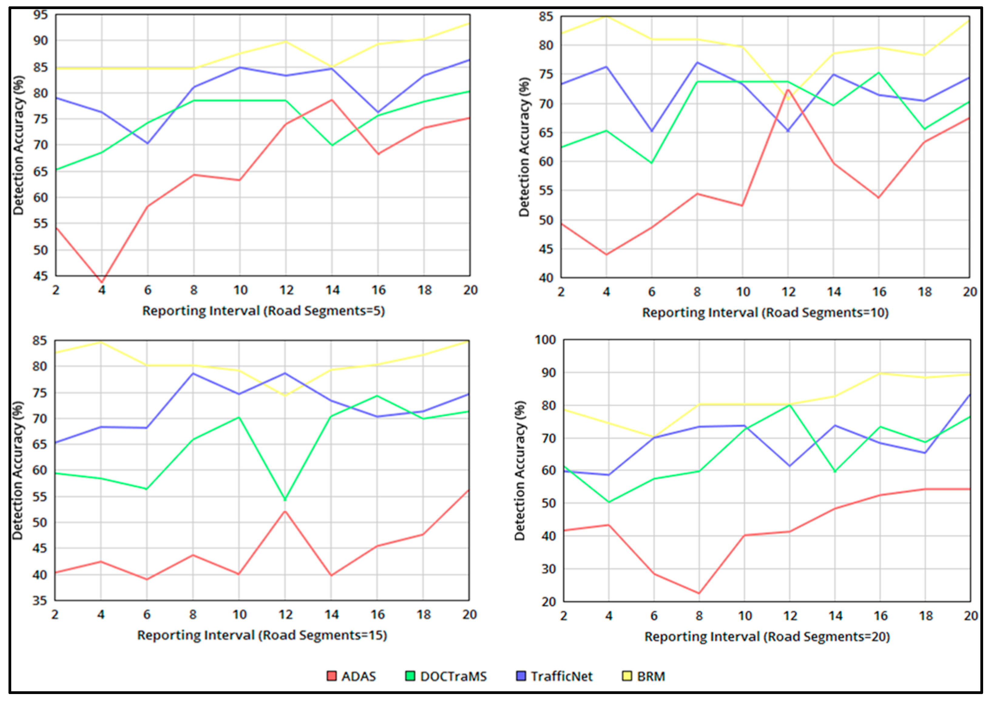
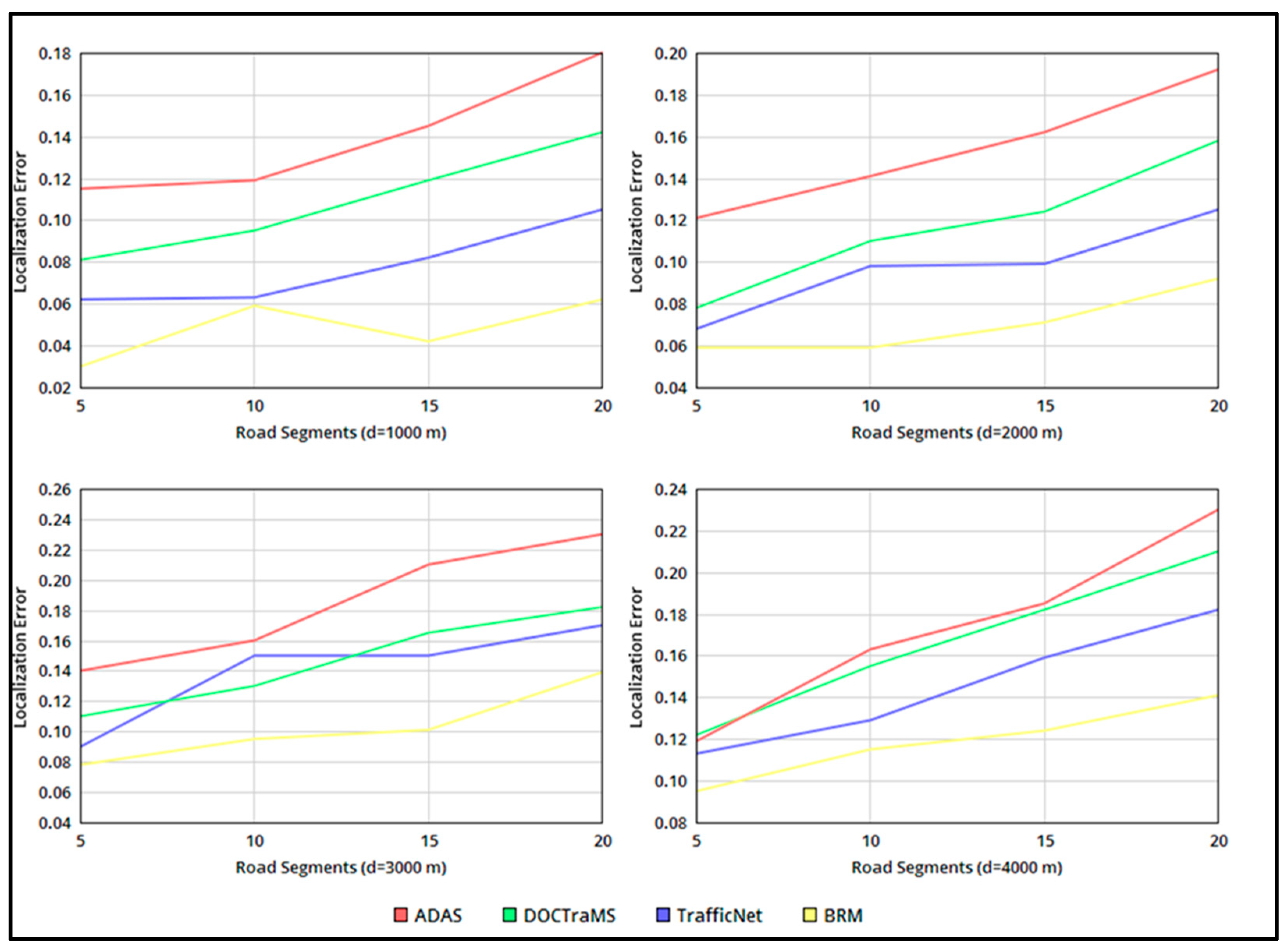
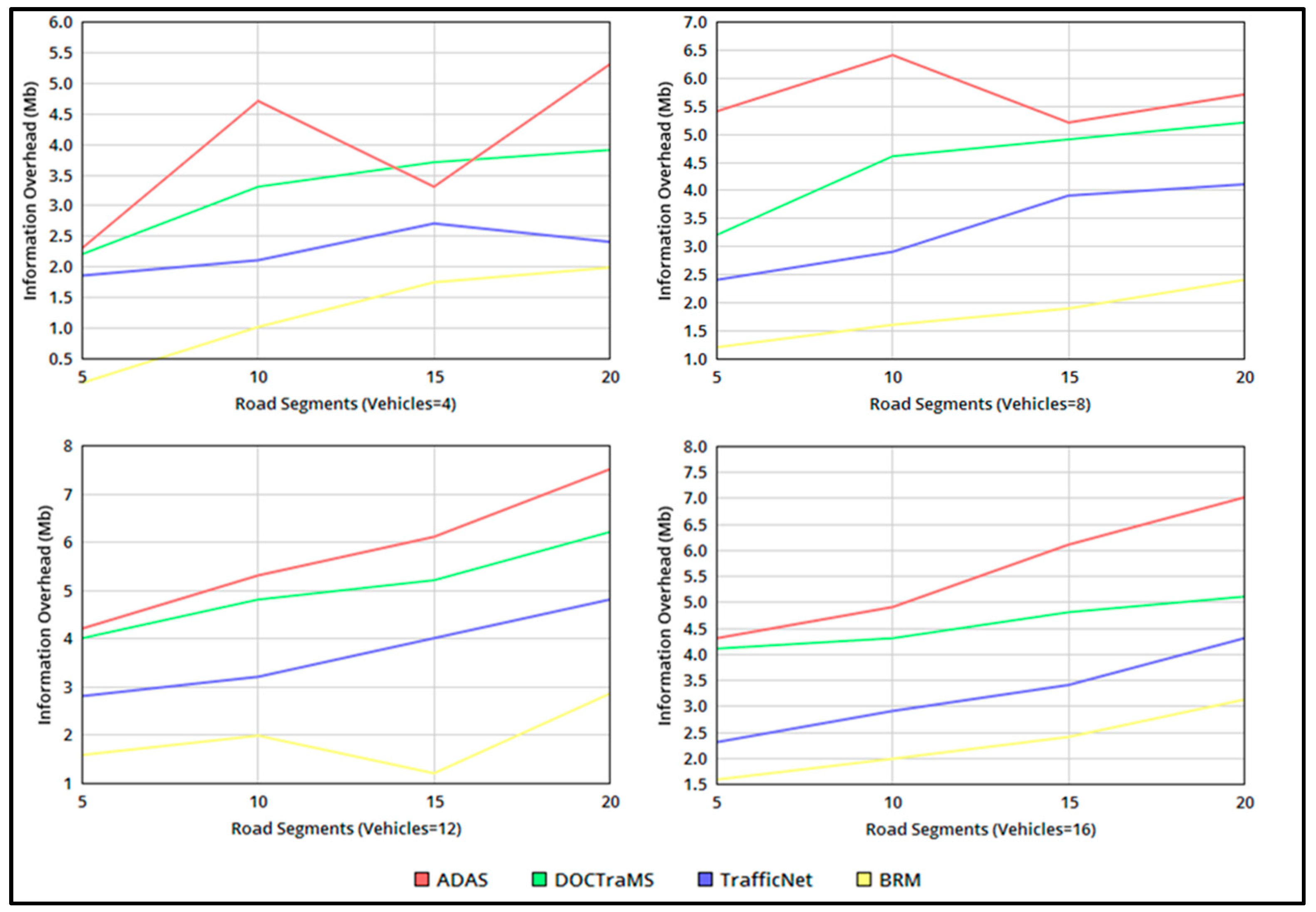
Section 4 presents the experimental results and an analysis of the proposed model, which are validated for the various inputs and intervals of the metrics, such as the detection accuracy, localization error, and information overhead. Finally, the conclusion in Section 5 summarizes the key findings and highlights the contribution of the proposed model to the field of ITS for smart cities.

2. Related Works

2.1. Roadside Monitoring for Vehicle Safety

Roadside monitoring for vehicle safety refers to a system that is installed along roads that utilizes various sensors and technology to monitor the traffic and provide driver assistance and safety warnings. This system aims to improve road safety by detecting potential hazards and alerting drivers to take necessary actions in real-time. This system involves a network of sensors, cameras, RADAR, LiDAR, and other advanced technologies that are installed along the roads. The data that are collected track the vehicle’s position, speed, and additional relevant information. This technology is especially useful for detecting dangerous driving behaviours, such as reckless driving, tailgating, and lane departure. The data that are collected are then processed by advanced algorithms to detect any potential dangers or deviations from safe driving behaviour. The monitoring results are used to provide real-time alerts or notifications to the drivers and information to traffic management centres for a proactive response. This system aims to improve road safety and reduce the number of accidents and fatalities on the roads. Roadside monitoring plays a crucial role in promoting road safety by identifying and addressing potential risks before they lead to accidents, and improving overall driving safety. Numerous research papers on designing and developing these roadside monitoring systems for vehicle safety, in the context of ITS for smart cities, have been published. Some of these studies are discussed below as background for this research.
Mfenjou et al. [13] proposed a communication network framework for ITS to provide surveillance within inter-urban transport networks, especially for low-income countries. The proposed architecture incorporates relay and treatment control points to form two multi-objective optimization models to gain information on the roadside environment. These optimization models focus on ensuring broad coverage, reducing installation costs, and prioritizing areas with high accident rates. The deployment of these control points is optimized by using a non-dominated sorted genetic algorithm II to identify the best possible solutions. The simulation results demonstrate the proposed solution’s effectiveness. This algorithm reduces the deployment costs and improves the coverage range. The study can investigate the detection and diffusion of disturbances within the inter-urban transport network and compare the performances of the implemented optimization algorithm with other optimization algorithms, by using various performance indicators. Kong et al. [14] designed a new traffic recommendation system for intelligent congestion and accident avoidance, using a deep learning model (DL). Their proposed system interconnected the Internet of Things and DL technology to predict the traffic parameters for designing their traffic recommendation system. The system first processed the traffic flow data with Internet of Things technology. Then, it utilized a long short-term memory (LSTM) neural network to predict the traffic congestion duration and spatial diffusion trends. The authors aimed to improve the practicality of traffic information services and increase the reliability and predictability of decision making for traffic managers and travellers. The results of their experiments demonstrated the effectiveness of their proposed recommendation system in extending the prediction horizon for traffic congestion and improving its reliability. This proposal is different from the communication network that forms the framework for the transport network. Based on these networks, forecast and traffic analyses are needed when using the method proposed below.
Wang et al. [15] employed a DL model using paths for the traffic speed forecasting in a city transportation system. To do this, the road network was divided into critical paths for an easier traffic flow analysis. A bi-directional LSTM neural network, followed by a fully connected layer, was used for forecasting the traffic speed by analysing the spatiotemporal features of the vehicles. Each critical path was processed using a bidirectional LSTM, and the stacking of multiple layers was performed to process the temporal features. The resulting spatial–temporal features were fed into a fully connected layer for a network-wide traffic speed prediction. The proposed framework was compared to multiple benchmark models, and it exhibited a better performance in various prediction scenarios, with different input and prediction horizons. The optimal hidden layer processing improved the qualitative and visualized output of the traffic forecasting. In this study, selecting critical paths is a crucial aspect of developing the model, and there is potential for a further analysis of more selection criteria.
Additionally, enhancing the interpretability of DL models for transportation applications is still a challenge that requires further research. Exploring ways to utilize this interpretability is also a promising area for future investigation. Event detection analysis requires a pre-classification and feature segregation to prevent additional layered processing. The complexities are suppressed by using protocol control and the flexibility that is provided in the upcoming proposal. Zhang et al. [16] proposed a discrete event detection method and designed a hybrid simulation platform within a connected automated vehicle environment to test and evaluate the performance of the vehicles. This framework permitted the user to test different control methods and communication protocols, in order to detect events in the corresponding automated vehicle environment. The simulation framework offered flexibility through various design paradigms, such as entity flow, graphical programming, and object-oriented programming in MATLAB, allowing its users to achieve complex goals. The framework’s flexibility was verified by incorporating different modelling elements into it to achieve a better event detection. Regardless of its flexibility, monitoring and extraction were prominent in deciding its accuracy factors. The communication protocol determined the rate of the monitoring data input. This required a pre-defined classifier with improved training, which was presented in the proposal [17].
In [17], a new classifier, TrafficNet, was created using convolutional neural networks that were based on two well-known networks, AlexNet and VGGNet. A support vector machine was used on top of the convolutional neural network architecture instead of a fully connected layer. The model was trained and tested for the congestion and non-congestion images that were extracted from surveillance videos and labelled manually. TrafficNet employed residual learning for a road congestion estimation using a traffic analysis. TrafficNet was modelled to scale a large region for traffic monitoring, using inputs from conventional monitoring systems. The results exhibited that the proposed method had an accuracy of up to 90%, much higher than traditional feature extraction methods without the DL approach. This DL-based model could be integrated into the current surveillance system to automatically detect and report traffic congestion. Almeida et al. [18] proposed a decentralized and offline community-based traffic monitoring system (DOCTraMS). This decentralized traffic monitoring system employed onboard and roadside units to collect information and update their records on the traffic conditions for each road segment. Through a seamless monitoring and information dissemination, this system helped to gain knowledge of the road traffic and congestion for the onboard units. A traffic validation was performed by partitioning the road into segments to identify the congestion more accurately. The system was tested with a real prototype, based on standard IEEE 802.11 b/g at the Universidade Federal do Rio de Janeiro campus, and with simulations that used traffic data from São Paulo, Brazil. The results showed that the system was 90% more accurate compared to a global positioning system. This system could be tested with the IEEE 802.11p standard and simulated for more traffic scenarios, in order to assess the system’s network traffic and evaluate its loss rate.
Arguedas et al. [19] presented a new approach to creating synthetic models of maritime traffic using self-reported positioning data. This historical data-based traffic representation model assisted in real-time monitoring. The method involved building a two-layer network that offered a fine-grained and accurate representation of traffic patterns. This representation network consisted of monitoring and an inner layer for providing infrastructure support and a precision analysis. The method was tested in a high-traffic density scenario in the Baltic Sea and showed a significant reduction in the storage data, with only a slight decrease in the precision. The resulting representation of maritime traffic lay the foundation for real-time traffic monitoring, anomaly detection, and situation prediction. Irrespective of the density of the vehicles and road conditions, this representation relied on self-organized data to achieve a high level of precision. Finogeev et al. [20] proposed an intelligent road monitoring system that assimilated fog, cloud, and mobile computing paradigms. This multi-agent system relied on the sensor data that were gathered from the environment. With the help of data gathering, clustering, and dissemination functions, the environment’s information was analysed optimally to provide smart road surveillance. The data processing results showed a comparison of traffic accidents and meteorological factors, which revealed the impact of meteorological conditions on the traffic in controlled areas. Gohar et al. [21] proposed a transport behaviour modelling model for ITS based on a big data analytics architecture in a smart city environment. The proposed model comprised four data acquisition, processing, analysis, and visualization modules. This modelling relied on self-storage and analytics functions to disseminate the appropriate controls for ITS efficiency. This method employed different processing and visualizing units to improve the vehicle throughput and speed detection. The architecture was validated using Hadoop for the storage and analysis of the ITS data and provided a detailed analysis of the vehicle speed over time. The results were promising, providing opportunities for further research.
Safety driving requires multi-data from the external environment at different intervals for adjusting and streamlining self-safety. This requires speed- or event-based data, as seen in [15,16,21], for precise traffic and travel condition monitoring, as seen in [17,18,19,20]. However, the recommendation for safe driving relies on external sorting and control relays for data handling and dissemination. This identifies the diverse data handling and processing level with various analytical procedures. Therefore, a fluctuation in the precision occurs due to common abnormal events. Different from the above discussion, the concepts for driving assistance are presented in the following subsection.

2.2. Driving Assistance

Driving assistance refers to the use of various systems and technologies to enhance road safety and the convenience of driving. These systems can be integrated into the vehicle or provided as road infrastructure. They provide drivers with warnings, alerts, or automated actions to help prevent accidents and ensure the vehicle’s safe operation. This can be achieved through various means, such as systems that assist with parking, lane departure warnings, adaptive cruise control, and other advanced driver assistance systems (ADASs). These systems aim to support the driver in making driving tasks easier and safer, reducing the risk of accidents and improving the overall driving experience. The concept of driving assistance has been the focus of much research and development in recent years, intending to make driving safer and more enjoyable for drivers and passengers. We reviewed multiple studies on designing and implementing these driving assistance systems using diverse technologies. These studies are presented and discussed in the context of the research background below.
In [22], the authors presented a position broadcasting application that was supported by ITS, for route discovery in smartphones. The authors created an Android app to alert regular vehicles about nearby emergency vehicles such as ambulances, police cars, and fire trucks. The application created a network of vehicles that could directly communicate with each other to allow drivers to make timely decisions. The application was tested in various scenarios and was found to provide alerts up to 300 m, within less than a second. This application was useful in assisting driving decisions by integrating the advantages of vehicular networks and connected vehicles. The application was reliable in determining the routes for evading obstacles, vehicle failures, and traffic congestion. This application could be incorporated with infrastructure and the internet, making it better suited for V2X communications. Curiel-Ramirez et al. [23] investigated the performance of a modular framework that assisted drivers in semi-automated driving. This research focused on developing an affordable driver assistance system to deal with issues such as congested traffic, self-parking, and detecting obstacles. The aim was to create a user-friendly system that people could easily adopt without technical knowledge. The growing availability of low-priced cameras and processing equipment makes building a cost-effective and powerful system possible. The authors demonstrated this concept by creating a hardware and software solution that employed a stereoscopic camera sensor for steering-wheel control in an autonomous manner. Regardless of the dissemination process, the assistance-based recommendations were presented using single and multi-vehicle platoons. Service discovery and communication were pursued using distinct vehicles and their dissemination.
Zhang et al. [24] analysed the effects of safety assistance driving systems on the oscillation magnitude, fuel consumption, and emissions in a car platoon, which was modelled by using an improved two-dimensional intelligent driver model. The classification of the driving conditions, which were based on the road conditions and information fetched that was from the environment, was used to model the safety assistance driving system. The classification of the dangerous and safety applications within the modelled system improved the driving reliability and vehicle management. Arbabzadeh and Jafari [25] proposed a new data-driven method to improve the performance of ADAS (DD-ADAS), which predicteds traffic safety risks based on individual driver characteristics and roadside information. The approach used an elastic net regularised multinomial logistic regression and naturalistic driving study data to create predictive models. The study included an examination of the variables and data preparation to enhance the prediction accuracy. This was a data-driven prediction method that independently customized safety conditions. The data dissemination relied on the vehicle and behaviour of the drivers for precise detection and safe driving. Therefore, a controlled steering environment was required to improve the driving assistance.
Zhao et al. [26] proposed a control method for hybrid vehicles during emergency steering evasions based on the driver’s behaviour. A CarSim model and a driving simulator analysed emergency steering evasion behaviours and defined the trigger for the assistance. A driver steering model was created to calculate the desired steering angle and yaw rate, and a yaw rate tracking controller and a steering torque assistance fuzzy controller were designed. The optimized preview distance improved the path-tracking accuracy and vehicle stability, and the results showed that the proposed assistance controller, which considered the driving behaviours, was effective. This method was designed for electric power steering vehicles to control and assist driving, and to prevent abnormal events. The tracking and torque monitoring controller information was fed to the proposed module to improve the driving safety. In the proposed framework, the driver behaviour and vehicle trajectory could be analysed in detail for more control and safety conditions. Yin et al. [27] introduced a new concept of dangerous driving intensity to improve driving safety and presented a framework to estimate this accurately. The framework involved optimizing fuzzy sets using a particle swarm optimization to model the attributes of drivers, vehicles, and lanes. The results were compared with the opinions of experienced drivers, who labelled the dangerous driving intensity. The findings demonstrated that the framework, which considered the driver, vehicle, and lane attributes, provided an accurate dangerous driving intensity estimation and could significantly improve the driving safety of intelligent vehicles, where the driver has a large role in driving risk. The proposed system was incorporated into ADASs to effectively enhance driving safety by identifying dangerous driving conditions for the driver. In [28], the authors presented an extensive, state-of-the-art review of the resource allocation of Cellular Vehicle-to-Everything, including a technical overview, the related works, and the differences, advantages, and challenges.
Based on the literature analysis, it was identified that driving assistance is provided through dedicated applications and steering recommendations, as seen in [22,26]. Such applications require self-assisted classifications for driving down the danger intensity [27,28]. Additionally, there is limited research on integrating behavioural attributes, such as driving time, localization errors, and trajectory conditions, into the analysis of driving assistance information. The problem is the dissimilar vehicle behaviour and the adaptable classification due to the interval data. These issues are the driving force in developing a robust and adaptable model that can effectively classify driving behaviour and provide accurate recommendations in real-time. Therefore, the authors propose a BRM to address the abovementioned issues, by identifying the precise data and best-fitting classification. However, several research gaps still need to be discussed in this area. One key gap is the lack of standardized approaches for modelling in-vehicle behaviour and responses. The existing models are context-specific and lack scalability across different cities and regions. Another gap is the limited use of real-time data in these models. Most existing models rely on historical data or fixed parameters, which may not accurately reflect the dynamic nature of traffic and driving behaviour.
Furthermore, there is a need for a better integration of these models with other ITS components, such as traffic management systems and intelligent infrastructure. This will require a greater collaboration between researchers, policymakers, and industry stakeholders to develop a comprehensive and integrated approach to ITS. Finally, there is a need to evaluate the effectiveness of in-vehicle behaviour-based response models for real-world settings. While there is growing evidence for the potential benefits of these models, further research is needed to validate their efficacy and identify any potential limitations or unintended consequences. Overall, addressing these research gaps will be critical for advancing the development and implementation of in-vehicle behaviour-based response models for traffic monitoring and driving assistance in smart cities. Therefore, the authors propose a BRM to address the abovementioned issues by identifying the precise data and best-fitting classification.

3. Proposed Behaviour-Based Response Model

The BRM is employed for detecting roadside incidents to provide better driving assistance for connected vehicles. The widespread cloud and the traffic safety applications within the smart city environment are exploited for this purpose. To improve its reliability, driving assistance, for location and incident accuracy, must be shared with fewer errors. Therefore, the physical attributes of the vehicles, in connection to their mobility and location patterns, are analysed to provide consistent and precise driving assistance using the BRM.

3.1. Application Modelling

The application model for real-time ITS scenarios consists of a digital interface that is equipped in the vehicle. This digital device (such as a touch screen, minicomputer, or digital device assistance) is connected to the vehicle’s radio and power unit. The digital device can receive radio signals and project them into visualizing images or message alerts. The device can communicate with the cloud and other networks using radio units. This communication is served using the existing roadside infrastructure units. The service availability, amid the change in the vehicle’s position, is ensured by the roadside infrastructure for retaining the service quality. The digital device interacts through an application and system software for information exchange.

3.2. Information Modelling

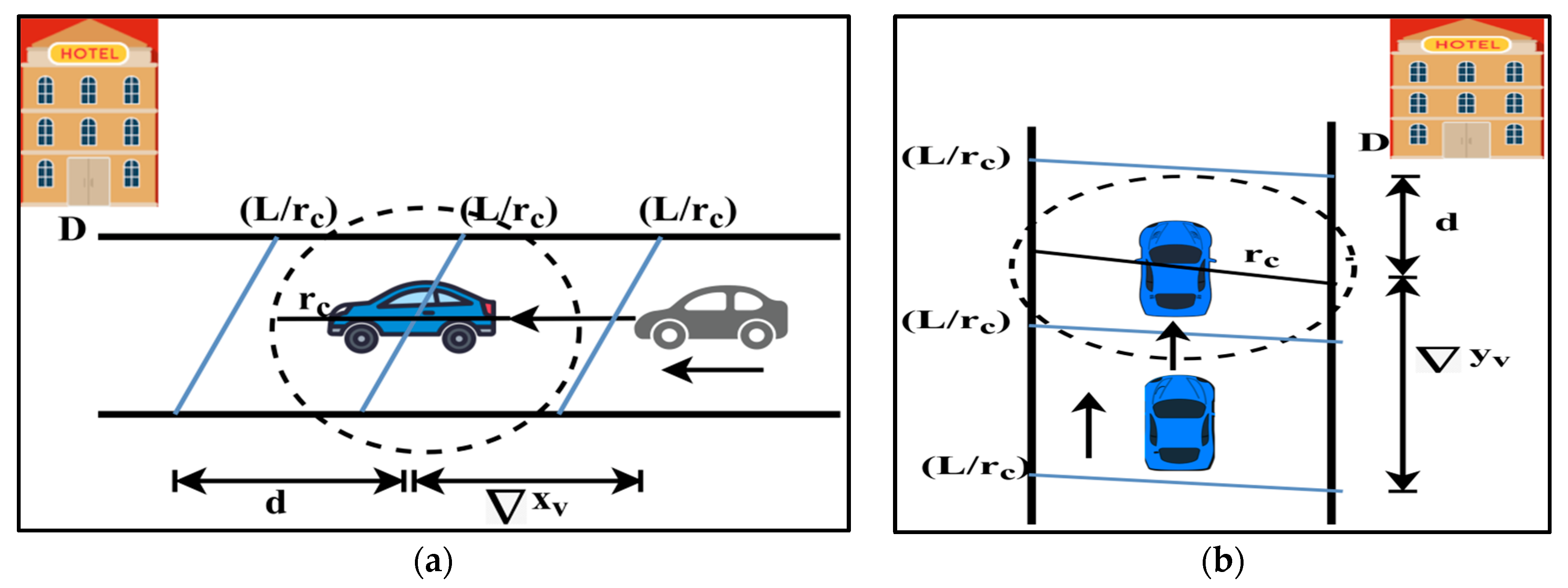
The information in the BRM relies on the environmental conditions and the response of the vehicles to these conditions. This is recorded as the incident from which the assistance is processed. The relating factor between the vehicle and roadside environment determines the incidents that are experienced for the following vehicles. The precision of the information processing must be high to prevent information falsification or misguided assistance. The input is expected to be quantized for a high level of information processing, which must meet the quality requirements. This means that the accountable inputs must provide the extraction of useful information. The usefulness of this information is verified based on the driving assistance that is provided to the user. Let d represent the road segment distance that connects the driving user and the fixed destination. This distance is computed using Equation (1).
d = ( x v x D ) 2 + ( y v y D ) 2 ,     i f   t h e r e   i s   n o   t r a j e c t o r y ( x v x D ) 2 c o s θ + ( y v y D ) 2 s i n θ ,   i f   t h e r e   i s   a   t r a j e c t o r y
Here, ( x v , y v ) and ( x D , y D ) stand for the position coordinates of the vehicle v and destination D . The variable θ denotes the angle of deviation between the two vehicles. The conditions “if there is no trajectory” and “if there is a trajectory” indicate the vehicle movement pursuing the same or different directions. In particular, the moving speed of the vehicle for the turn around the new vehicle is considered in this trajectory. The time required to travel the distance, d i . e   t d , is computed in Equation (2).
t d = t ^ d i d t d i * t a i
where, t ^ d , t d i * and t a i are the previous last known travel time of v , the current expected time of the previous distance, and the time information of the vehicle, which is stored in the cloud, from which the expected times ( t d i * ) and t a i are zero, meaning the velocity of the vehicle is constant. On the other hand, if there is a variation in these factors, in particular, if ( t d i * < t a i ) , then the incident is experienced by the vehicle. This incident can be a road traffic or intersecting traffic signal, etc. However, if there is an adverse identification, driving assistance must be invoked to provide knowledge of the road scenario. If the length of the road is L , and the radio coverage range of the vehicle is r c , then L / r c is the available partitions in d . The t ^ d that is computed in any of L / r c is computed as:
t ^ d = i d t d i * 1 / t a i i d , j L / r c 1 / t a i j
The time that is computed using Equation (3) validates the segment/partition of the road that is covered by the vehicle. Equation (1) is revisited for the trajectory of the vehicle, because the above time is not a constant where the angle of deviation θ is observed. The angle of deviation determines the moving direction and trajectory that is experienced by the vehicle. The angle of deviation, θ , is estimated using Equation (4), as
θ = cos 1 x v + y v x 2 v
where,   x v   and   y v are the changes in the coordinate positions of the vehicle for the x and y axis representations. The road segment L encompasses multiple intersections that cause the change in d and t d . In such a case, the precision error η is computed using Equation (5).
η = 1 r c x v r c ,   i f   t h e   v e h i c l e   i s   m o v i n g   a l o n g   x a x i s 1 r c y v r c ,   i f   t h e   v e h i c l e   i s   m o v i n g   a l o n g   y a x i s
In Figure 1a,b, the illustrations of x v and y v are displayed.
As per the representation in Figure 1a,b, t ^ d = x v or y v if the vehicle moves along the x or y a x i s , respectively. Now, the set of inputs that are analysed are ( t d , η   and   θ ) .
Let B denote the behaviour attributes of a vehicle that is denoted as B t d , η , θ v with r c and d 0 conditions. These behaviour attributes are classified using the regression learning model, as discussed in the next section.

3.3. Behaviour Modelling

The behaviour modelling follows a step-by-step procedure using regression learning to estimate the incident, location, and cause, which are reported to the pursuing connected vehicle to assist the driving users. The members of B are independently analysed, and then the constraints due to the joint validation are analysed to provide a granular information extraction. The application model and user experience rating verify the usefulness of the information. This fact is applicable in a real-time scenario for estimating the information usefulness. Depending on the available information, the utilization determines its usefulness. This usefulness is decided using the vehicle behaviour, assistance, and safe driving attributes. The data analysis requires intense training and verification for validity across multiple intervals. Therefore, the behaviour model design relies on previous user experiences. The regression-based analysis for incident detection is pursued in the same order as t d ,   η , and θ . This learning analysis exploits the relationship between the independent attributes to improve its reliability in information extraction. The analysis is presented below, along with the explanation.
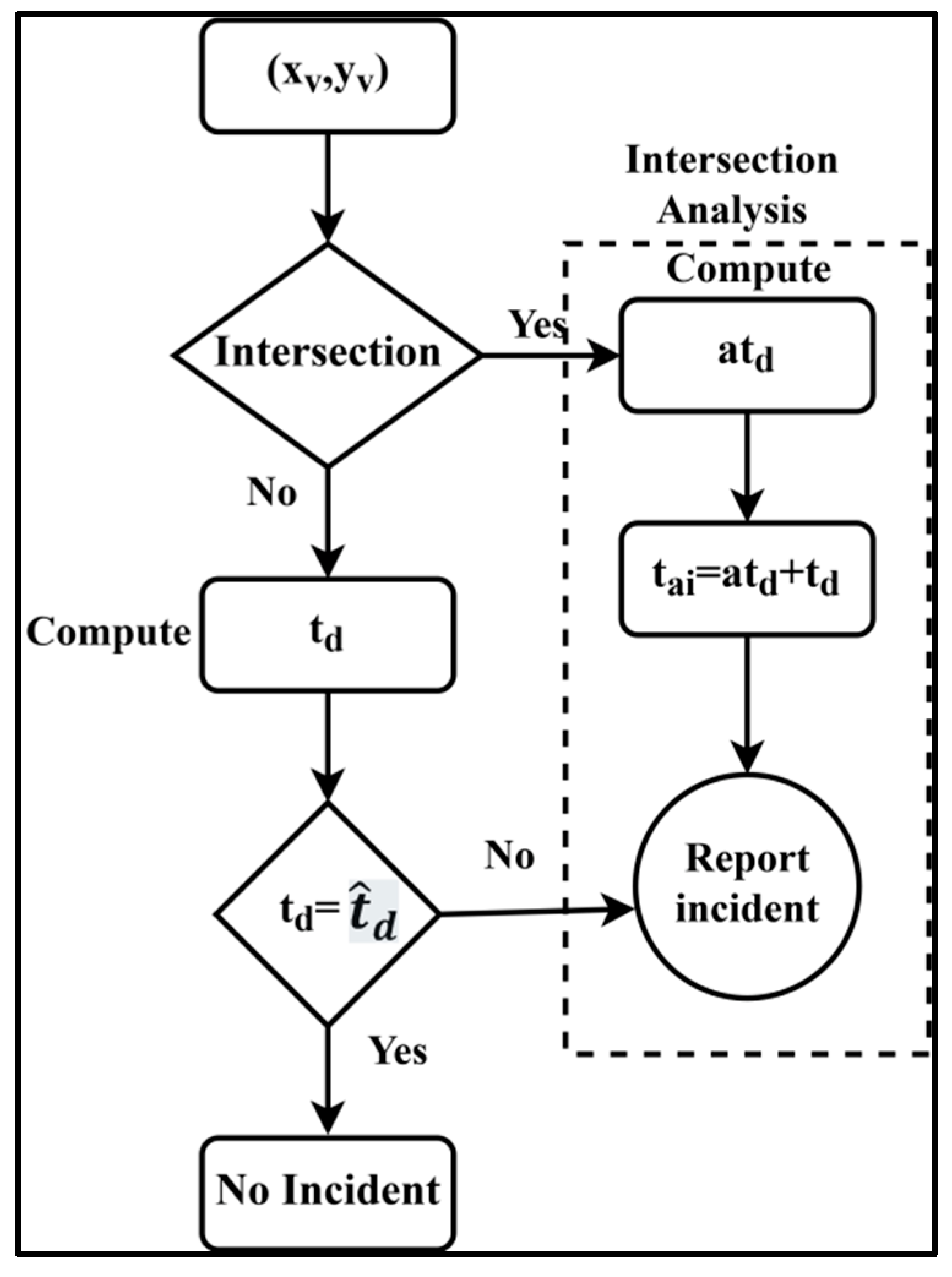
3.4. Analysis 1: Conditions for t d Validation

The driving time towards a fixed D reduces as the segment count decreases. This is observed for a non-intersecting road. Let a t d represent the additional time that is experienced in reaching D . This can be because of a traffic signal or congestion that is experienced in L . Therefore, the regression analysis is modelled in Figure 2 for an intersecting and non-intersecting L .
The non-intersecting L causes no change in t d , whereas the intersecting L experiences some delay in covering the distance d . Therefore, the location precision for the time η t is computed as
η t = η + d × t d a t d × x v ,   i f   m o v i n g   i n   x a x i s η + d × t d a t d × y v ,   i f   m o v i n g   i n   y a x i s
In the estimation of η t , as in Equation (6), the arrival time of the vehicle is postponed by a t d , which is verified as η t η ) × x v = d . If this condition is experienced, the incident is reported as a delay in the time that is experienced by the predecessor vehicle to the pursuing vehicle.

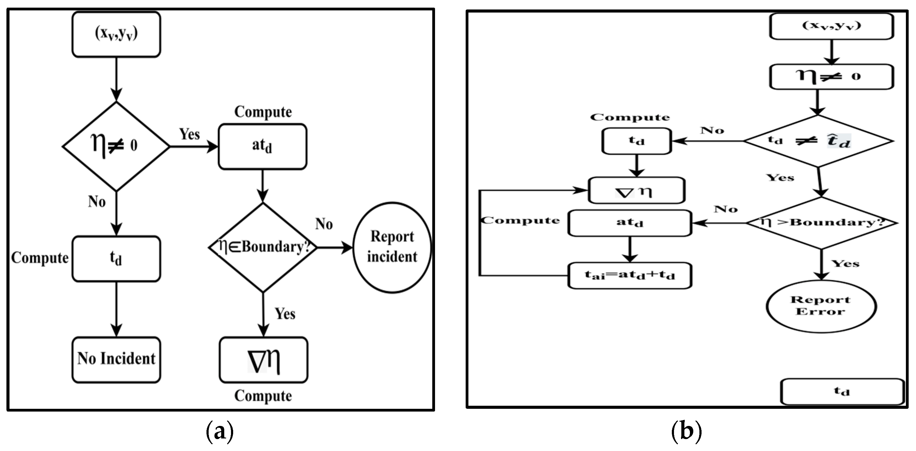
3.5. Analysis 2: Validation of η

The error in determining the position of the vehicle is based on the velocity and time in L / r c . This error misguides the incident update by falsifying the location to the user in the driving assistance. Therefore, in the regression process, the analysis of η is performed linearly. If x denotes the input constraint for η , then the validating input is η v = α 1 + α 2 x , where α 1 and α 2 are the input co-efficients in correspondence with the η that is observed in t ^ d and a t d . Now, the objective of the regression is to achieve the min α 2 as α 1 0 if t d = t a i . Therefore, the variation of η v for η (i.e.,) η is computed using Equation (7), as:
η = 1 L / r c i = 1 L / r c ( η i η v i )
The variation that is observed using Equation (6) changes with the vehicle’s velocity. The chance of an error in the above analysis varies due to neighbouring vehicles and road conditions. Therefore, the boundary for differentiating η and η v is defined for the varying η due to different velocities and densities. This boundary is useful in validating η across all the road segments; if the value of η lies within the boundary, then the location error is less, and the incident is of the normal clause. Instead, if η is found to lie behind or above the boundary, then the localization error is high, for which a notification is necessary. The boundary between η and η (i.e.,) b η η is computed using Equation (8).
b η η = 1 η + L L r c η η L ,   L η η r c
The boundary that is defined in Equation (7) specifies a minimum value of 1 η + L L r c η η L and a maximum value of L r c η η for the x v , y v of a vehicle that is located during t d . From here, the relationship analysis is performed. Before this analysis, a representation of the regressive processes for the boundary and relationship conditions is illustrated in Figure 3a,b, respectively.
In Figure 3a, the position of the vehicle and its corresponding boundary failing condition generates notifications (report incident). This case is analysed as the joint processing using a t d and η in Figure 3b, where the condition of the η boundary is split into η > b o u n d a r y and η < b o u n d a r y for an independent analysis. This validates the condition that does not require a notification (incident reporting), but a localization error exists. This means that the availability of the vehicle is true and its driving time is some, whereas the location (positioning) error is observed due to the x v or y v being changed, which results in η in this case.

3.6. Relation Modelling (Analysis 1: Analysis 2)

The change in t d that is observed due to the η in any L / r c causes additional driving time a t d . The vehicle’s location that is estimated in this condition is unsatisfactory, and the vehicle detects an incident to be reported. This reporting is reflected in the navigation and driving assistance process that is adopted by the pursuing vehicle. For the L / r c , the segment along distance d and the boundary using the t d and η are modelled as follows.
( b η η ) 1 = 1 η + L L 1 r c η L 1 ,   a s η = 0   f o r   t h e   f i r s t   s e g m e n t ( b η η ) 2 = 1 ( b η η ) 1 + L 2 L 2 r c η ( b η η ) 1 L 2 ,   ( b η η ) 2 = 1 ( b η η ) d 1 + L d 1 L d 1 r c η ( b η η ) d 1 L d 1
From Equation (9), the range of b η η is 1   t o   d , and the distance is scaled between L L 1 r c η L   1 η to 1 η +   L L 1 r c   η η L for the independent metric η . For a time, this range is valid from t d to t d + a t d , which provides η t η t d = d v e l o c i t y as the satisfying condition. Therefore, the required time for achieving less η is L r c t a i = a t d + t d , where the velocity of the vehicle is constant. If there is a change in the velocity, then t ^ d t d and therefore, L r c t a i = a t d + t ^ d is the expected time delay for balancing η in the abovementioned range.

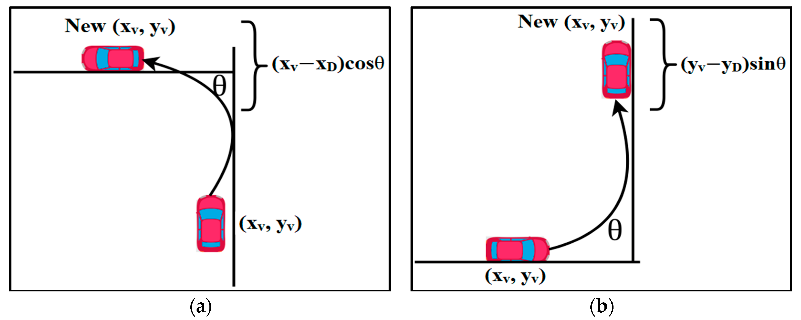
3.7. Analysis 3: Evaluation of θ

The change in the angle of deviation determines the trajectory of a vehicle. The trajectory of the vehicle is used to identify the moving directions and changes in the route plan. A change in the route plan is notified to the pursuing user. Therefore, the trajectory information is to be analysed for the pursuing vehicle. The vehicle moving before is the reference for the trailing vehicle to identify the direction of movement. Instead, the moving vehicle is dependent on the road segment and L to change its direction. The angle of trajectory along the road segment does not need to be notified. On the other hand, if there is a change in the driving plan due to abnormal events (such as accidents or congestion), then this variation is to be reported to the trailing vehicle as a notification. The error is computed for the deviation/miscomputation of the position. The error with o is given by Equation (10).
η θ = x v x D c o s θ 1 x ,   i f   t h e   v e h i c l e   c h a n g e s   t o   h o r i z o n t a l   p l a n e y v y D s i n θ 1 y ,   i f   t h e   v e h i c l e s   c h a n g e s   t o   v e r t i c a l   p l a n e
The change in the plane for validating η θ is represented in Figure 4a,b, respectively.
However, the regression process is the same, where the distance error is computed using Equation (11).
η d 1 = x v 1 x D c o s θ 1 y v 1 y D η d 2 = x v 2 x D c o s θ 2 y v 2 y D η d 1 η d L = x v L 1 x D c o s θ L 1 y v L 1 y D η d L 1
The error that is observed in this case is considered for all the L r c in d to verify if the vehicle has settled its position in the horizontal/vertical plane. The displacement distance is also augmented to the travel time of the vehicle to estimate a t d .

3.8. Relation Modelling (Analysis 1, 2, 3)

The relationship between η θ and b η η d for t d   a n d   η is given as
t d = t a i + η d L × a t d + η θ × b η η × t ^ d ]
In Equation (12), t d is modelled based on θ and η to estimate the delay time in reaching the destination. The notification here is confined to the basis of b η η d and η θ to reduce unnecessary event detection. This improves the accuracy of the driving assistance by suppressing the localization errors. The notification is followed for precise event detection, and driving assistance is ensured with this non-overloaded formation. 
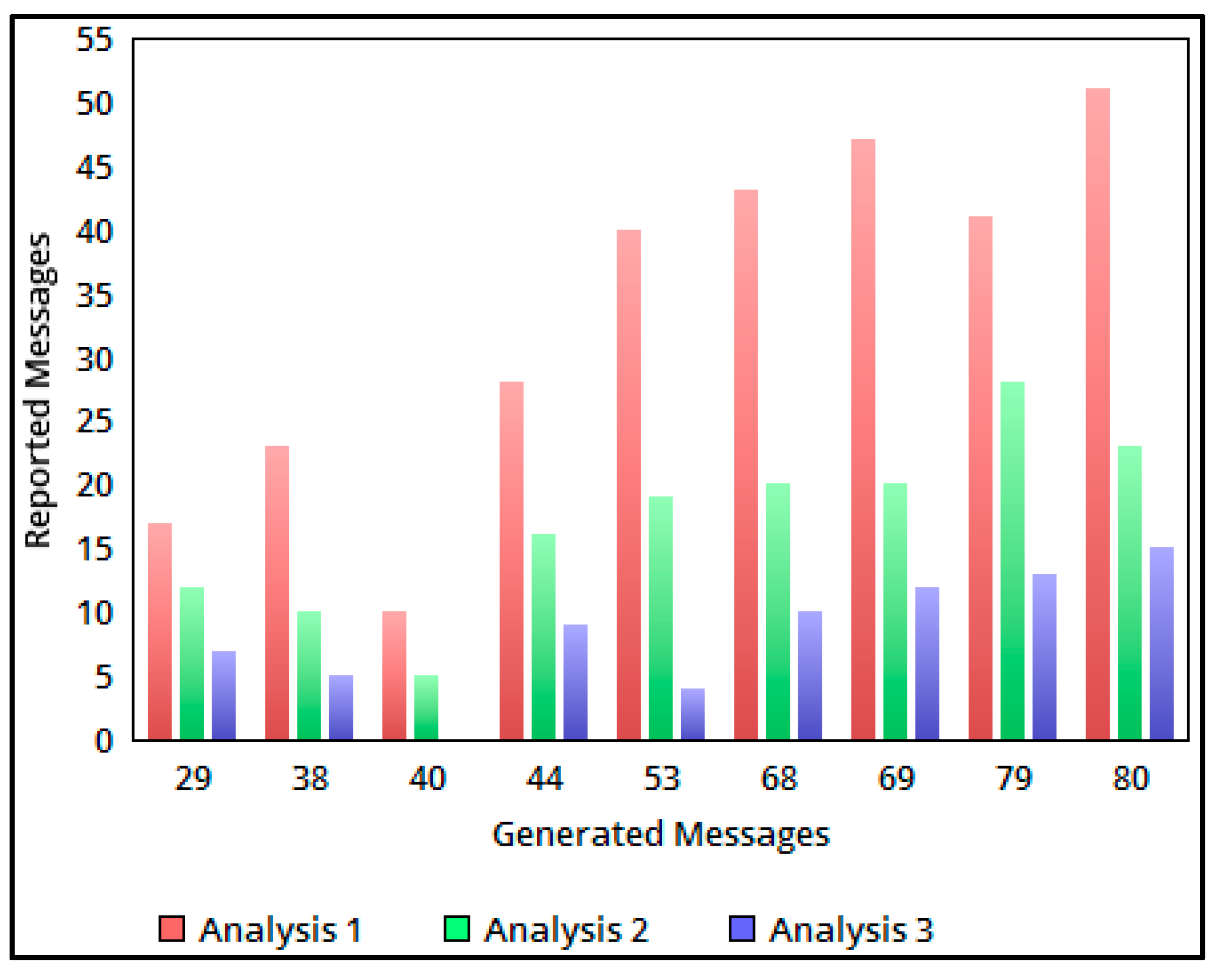
Figure 5 represents the comparative analysis of the generated detection and refined messages through analyses 1, 2, and 3.
As discussed above, the reported messages are classified in each analysis step by using different conditional verifications. In the above illustration, analysis 1 to analysis 3 corresponds to t d , η and θ validation in the process of identifying prompt messages. The values of the above illustration are presented in Table 1.

4. Experimental Result and Analysis

The proposed behaviour model for ITS is verified using experiments that are carried out using the OPNET modeller. In an open scenario of the modeller, 16 vehicles are initially set to provide navigation and incident detection, with the help of an information exchange. In this scenario, five roadside units and one cloud storage are deployed. The vehicles communicate through a range of a 512 Kbps–1024 Kbps bandwidth that is shared by the roadside units. A region with dimensions of 4000 m × 4500 m bounds the open scenario. There are seven intersections in the driving scenario where the vehicles exchange more information through V2V and vehicle-to-infrastructure communication modes. The vehicles are permitted to exchange information at regular intervals of 2 min. With this detailing in the experimental setup, the event detection accuracy, localization error, and information overhead are compared with the existing results on DD-ADAS [25], DOCTraMS [18], and TrafficNet [17].

4.1. Detection Accuracy

The detection accuracy for the varying reporting intervals is compared in Figure 6 for the different road segments. The detection of the incident is identified based on the useful information that models B . In the estimated t d along L r c , the incident detection notification is filtered based on the relationship that is modelled between t d   η and θ . The regression analysis model exploits the relationship between t d and η to identify the events based on a t d . In the second relationship modelling, the incident is classified based on error. This means the incident is negligible, with an information error where η > boundary, but   t a i = a t d + t d . Similarly, the number of notifications due to the η boundary originated as accuracy in the η validation. Considering the relationship between t d ,   η , and θ as whole, the factor b η η serves as the refining condition. Therefore, the accuracy is computed as information and B t d ,   B η ,   B θ is disseminated as the report for the navigation. The actual generated information, i.e., B t d ,   B η ,   B θ , is refined to improve the accuracy of the incident detections in all the L r c . The comparative analysis results for the detection accuracy are presented in Table 2.

4.2. Localization Error

The localization error in the proposed behaviour modelling is less, irrespective of the distance and road segments. The L r c -divided road segments are analysed using the relationship of analyses 1, 2, 3, using η θ and b η η . The d varies with the change in the road segment and x v , y v also varies, resulting in a 1 x v x v error at the time of localization. In the existing methods, the vehicles’ trajectory is not accounted for, whereas the previously stored information is accounted for when estimating the localization error. Instead, in the BRM, d is validated for the change in the plane (vertical or horizontal) and η θ where η > boundary conditions. In these violating conditions, the deviation in η θ is high, resulting in a misguided notification (navigation/driving assistance). For these conditions where η boundary, the θ is validated to find the precise location of the vehicles, i.e., x v x d c o s θ or   y v y D s i n θ . If η > b η η , then the localization error is high; therefore, the change in x v y v , i.e., x v , y v are updated as the new position of the vehicle. The η b o u n d a r y condition is satisfied by the updated position, which results in less 1 x v x v and   1 y v y v , reducing the localization error, which is shown in Figure 7. In Table 3, the localization error for the above comparison is tabulated.

4.3. Information Overhead

Due to the frequent exchange of information, the navigation/driving assistance message that is shared from the heading vehicle is high. This increases the information overhead and also decreases the efficiency of the driving assistance system. Figure 8 analyses the information overhead for the varying road segments and vehicle densities. In all four cases, the information is filtered based on a regression analysis. The behaviour model is defined using t d ,   η and θ , and then the independent and joint (relationship) analyses are performed step-by-step. In each case, the expected and actual t d is computed, within which the η , due to localization, and t d , the trajectory, are verified for condition satisfaction. The information exchanged in the a t d t d interval for L r c is filtered using η d L and η θ (based on trajectory). Some conditions, such as the η > b o u n d a r y and t a i = a t d + t d , are handled as exceptions, in which the information is not disseminated, whereas the error in the localization for the trajectory or time is reported. Therefore, the necessary information sharing in the proposed BRM at the η t intervals is restricted, reducing the information overhead. The comparative analysis of the information overhead is presented in Table 4.

5. Conclusions

This paper presents a BRM for providing reliable driving assistance information to ITS users in a smart city environment. The proposed model classifies the useful information based on regression analyses, by defining the independent and joint analyses of the behavioural attributes. These attributes are defined based on the driving time, localization error, and trajectory conditions, in order to refine the useful information from the exchanged information. This process is performed dependently to identify the less information overhead that is used for assisting driving in the trailing connected vehicles. The experimental process shows that the proposed BRM achieves a high detection accuracy and less information overhead and localization errors. The results showed that the proposed model provides an efficient and effective solution for traffic monitoring and driving assistance in the context of smart cities. This model generates recommendations for traffic-congestion-free driving assistance, with a reduced reactive time. The model uses the smart computation capabilities of connected vehicles and the cloud to gather and analyse traffic conditions, and to provide assisted driving recommendations to users. Though the model is reliable in achieving high roadside assistance under a controlled overhead, multi-variation data handling is less feasible. Therefore, incorporating a self-decisive data handling process can be planned. This process performs a classification and data analysis using multiple traffic and vehicle observation instances. Therefore, the data must be multimodal to prevent varying analyses. Future work on in-vehicle behaviour-based response models for traffic monitoring and driving assistance in smart cities may involve developing more sophisticated and adaptable models, improving user interfaces, establishing standard protocols and regulations, and evaluating the effectiveness and impact of these models in real-world settings. The focus will be on interdisciplinary collaboration, scalability, adaptability, and user-friendliness.

Author Contributions

Conceptualization, G.D., M.A. and S.S.; methodology, G.D., M.A. and S.S.; software, M.A. and S.S.; validation, M.A., S.S., G.D. and H.F.G.; formal analysis, G.D. and H.F.G.; resources, S.S.; data curation, G.D., H.F.G. and S.S.; writing—original draft preparation, M.A. and S.S.; writing—review and editing, G.D., H.F.G. and S.S.; visualization, G.D., H.F.G. and S.S. All authors have read and agreed to the published version of the manuscript.

Funding

This research was supported by the Princess Nourah bint Abdulrahman University Researchers Supporting Project number (PNURSP2023R259), Princess Nourah bint Abdulrahman University, Riyadh, Saudi Arabia.

Data Availability Statement

Not applicable.

Conflicts of Interest

The authors declare no conflict of interest.

References

  1. Yang, D.; Jiang, K.; Zhao, D.; Yu, C.; Cao, Z.; Xie, S.; Xiao, Z.; Jiao, X.; Wang, S.; Zhang, K. Intelligent and connected vehicles: Current status and future perspectives. Sci. China Technol. Sci. 2018, 61, 1446–1471. [Google Scholar] [CrossRef]
  2. Wang, Y.; Yan, Y.; Shen, T.; Bai, S.; Hu, J.; Xu, L.; Yin, G. An event-triggered scheme for state estimation of preceding vehicles under connected vehicle environment. IEEE Trans. Intell. Veh. 2022, 8, 583–593. [Google Scholar] [CrossRef]
  3. Maglogiannis, V.; Naudts, D.; Hadiwardoyo, S.; van den Akker, D.; Marquez-Barja, J.; Moerman, I. Experimental V2X Evaluation for C-V2X and ITS-G5 Technologies in a Real-Life Highway Environment. IEEE Trans. Netw. Serv. Manag. 2022, 19, 1521–1538. [Google Scholar] [CrossRef]
  4. Ilié, J.-M.; Chaouche, A.-C. Toward an Efficient Ambient Guidance for Transport Applications. Procedia Comput. Sci. 2017, 110, 190–198. [Google Scholar] [CrossRef]
  5. Girbes, V.; Armesto, L.; Dols, J.; Tornero, J. An Active Safety System for Low-Speed Bus Braking Assistance. IEEE Trans. Intell. Transp. Syst. 2017, 18, 377–387. [Google Scholar] [CrossRef] [Green Version]
  6. Qi, X.; Wu, G.; Hao, P.; Boriboonsomsin, K.; Barth, M.J. Integrated-Connected Eco-Driving System for PHEVs With Co-Optimization of Vehicle Dynamics and Powertrain Operations. IEEE Trans. Intell. Veh. 2017, 2, 2–13. [Google Scholar] [CrossRef] [Green Version]
  7. Altun, M.; Celenk, M. Road Scene Content Analysis for Driver Assistance and Autonomous Driving. IEEE Trans. Intell. Transp. Syst. 2017, 18, 3398–3407. [Google Scholar] [CrossRef] [Green Version]
  8. Chu, D.; Deng, Z.; He, Y.; Wu, C.; Sun, C.; Lu, Z. Curve speed model for driver assistance based on driving style classification. IET Intell. Transp. Syst. 2017, 11, 501–510. [Google Scholar] [CrossRef]
  9. Wang, J.; Zhang, G.; Wang, R.; Schnelle, S.C.; Wang, J. A Gain-Scheduling Driver Assistance Trajectory-Following Algorithm Considering Different Driver Steering Characteristics. IEEE Trans. Intell. Transp. Syst. 2017, 18, 1097–1108. [Google Scholar] [CrossRef]
  10. Jeon, M.; Yang, E.; Oh, E.; Park, J.; Youn, C.-H. A Deterministic Feedback Model for Safe Driving based on Nonlinear Principal Analysis Scheme. Procedia Comput. Sci. 2017, 113, 454–459. [Google Scholar] [CrossRef]
  11. Kim, S.-Y.; Kang, J.-K.; Oh, S.-Y.; Ryu, Y.-W.; Kim, K.; Park, S.-C.; Kim, J. An Intelligent and Integrated Driver Assistance System for Increased Safety and Convenience Based on All-around Sensing. J. Intell. Robot. Syst. 2007, 51, 261–287. [Google Scholar] [CrossRef]
  12. Xue, J.-R.; Fang, J.-W.; Zhang, P. A Survey of Scene Understanding by Event Reasoning in Autonomous Driving. Int. J. Autom. Comput. 2018, 15, 249–266. [Google Scholar] [CrossRef]
  13. Mfenjou, M.L.; Ari, A.A.A.; Njoya, A.N.; Mbogne, D.J.F.; Kolyang; Abdou, W.; Spies, F. Control points deployment in an Intelligent Transportation System for monitoring inter-urban network roadway. J. King Saud Univ.—Comput. Inf. Sci. 2022, 34, 16–26. [Google Scholar] [CrossRef]
  14. Kong, F.; Li, J.; Lv, Z. Construction of intelligent traffic information recommendation system based on long short-term memory. J. Comput. Sci. 2018, 26, 78–86. [Google Scholar] [CrossRef]
  15. Wang, J.; Chen, R.; He, Z. Traffic speed prediction for urban transportation network: A path based deep learning approach. Transp. Res. Part C: Emerg. Technol. 2019, 100, 372–385. [Google Scholar] [CrossRef]
  16. Zhang, Y.; Cassandras, C.G.; Li, W.; Mosterman, P.J. A Discrete-Event and Hybrid Simulation Framework Based on SimEvents for Intelligent Transportation System Analysis. IFAC-Pap. 2018, 51, 323–328. [Google Scholar] [CrossRef]
  17. Wang, P.; Li, L.; Jin, Y.; Wang, G. Detection of unwanted traffic congestion based on existing surveillance system using in freeway via a CNN-architecture trafficnet. In Proceedings of the 2018 13th IEEE Conference on Industrial Electronics and Applications (ICIEA), Wuhan, China, 31 May–2 June 2018. [Google Scholar]
  18. Almeida, T.T.D.; Nacif, J.A.M.; Bhering, F.P.; Junior, J.G.R. DOCTraMS: A Decentralized and Offline Community-Based Traffic Monitoring System. IEEE Trans. Intell. Transp. Syst. 2019, 20, 1160–1169. [Google Scholar] [CrossRef]
  19. Arguedas, V.F.; Pallotta, G.; Vespe, M. Maritime Traffic Networks: From Historical Positioning Data to Unsupervised Maritime Traffic Monitoring. IEEE Trans. Intell. Transp. Syst. 2018, 19, 722–732. [Google Scholar] [CrossRef]
  20. Finogeev, A.; Finogeev, A.; Fionova, L.; Lyapin, A.; Lychagin, K.A. Intelligent monitoring system for smart road environment. J. Ind. Inf. Integr. 2019, 15, 15–20. [Google Scholar] [CrossRef]
  21. Gohar, M.; Muzammal, M.; Rahman, A.U. SMART TSS: Defining transportation system behavior using big data analytics in smart cities. Sustain. Cities Soc. 2018, 41, 114–119. [Google Scholar] [CrossRef]
  22. Hadiwardoyo, S.A.; Patra, S.; Calafate, C.T.; Cano, J.-C.; Manzoni, P. An Intelligent Transportation System Application for Smartphones Based on Vehicle Position Advertising and Route Sharing in Vehicular Ad-Hoc Networks. J. Comput. Sci. Technol. 2018, 33, 249–262. [Google Scholar] [CrossRef]
  23. Curiel-Ramirez, L.A.; Ramirez-Mendoza, R.A.; Carrera, G.; Izquierdo-Reyes, J.; Bustamante-Bello, M.R. Towards of a modular framework for semi-autonomous driving assistance systems. Int. J. Interact. Des. Manuf. (IJIDeM) 2018, 13, 111–120. [Google Scholar] [CrossRef]
  24. Zhang, X.; Jia, B.; Jiang, R. Impact of safety assistance driving systems on oscillation magnitude, fuel consumption and emission in a car platoon. Phys. A Stat. Mech. Its Appl. 2018, 505, 995–1007. [Google Scholar] [CrossRef]
  25. Arbabzadeh, N.; Jafari, M. A Data-Driven Approach for Driving Safety Risk Prediction Using Driver Behavior and Roadway Information Data. IEEE Trans. Intell. Transp. Syst. 2018, 19, 446–460. [Google Scholar] [CrossRef]
  26. Zhao, Z.; Zhou, L.; Luo, Y.; Li, K. Emergency Steering Evasion Assistance Control Based on Driving Behavior Analysis. IEEE Trans. Intell. Transp. Syst. 2019, 20, 457–475. [Google Scholar] [CrossRef]
  27. Yin, J.-L.; Chen, B.-H.; Lai, K.-H.R.; Li, Y. Automatic Dangerous Driving Intensity Analysis for Advanced Driver Assistance Systems from Multimodal Driving Signals. IEEE Sens. J. 2018, 18, 4785–4794. [Google Scholar] [CrossRef]
  28. Sehla, K.; Nguyen, T.M.T.; Pujolle, G.; Velloso, P.B. Resource Allocation Modes in C-V2X: From LTE-V2X to 5G-V2X. IEEE Internet Things J. 2022, 9, 8291–8314. [Google Scholar] [CrossRef]
Figure 1. (a) x v change, and (b) y v Change.
Electronics 12 01644 g001
Figure 2. Regression analysis for intersection and non-intersection.
Electronics 12 01644 g002
Figure 3. (a) boundary condition, and (b) relationship modelling.
Electronics 12 01644 g003
Figure 4. (a) Horizontal plane change, and (b) vertical plane change.
Electronics 12 01644 g004
Figure 5. Generated messages versus reported messages.
Electronics 12 01644 g005
Figure 6. Analysis of detection accuracy of different road segments.
Electronics 12 01644 g006
Figure 7. Analysis of localization error in different road segments.
Electronics 12 01644 g007
Figure 8. Analysis of information overhead different numbers of vehicles.
Electronics 12 01644 g008
Table 1. Generated and reported messages.
Generated MessagesAnalysis 1Analysis 2Reported Messages
Analysis 3
2917117
3823103
401050
4428169
5340194
68442410
69472013
79472813
80512315
Table 2. Detection accuracy comparisons.
MetricRoad SegmentDD-ADASDOCTraMSTrafficNetBRM
Detection Accuracy (%)575.0981.2485.692.49
1067.2870.2174.1983.26
1555.2772.4973.4384.39
2057.7276.2884.3989.93
Table 3. Localization error analysis.
Metricd (m)DD-ADASDOCTraMSTrafficNetBRM
Localization Error10000.1790.1430.1090.06117
20000.1910.1580.1260.0928
30000.2270.1810.1730.138
40000.2310.2030.1870.143
Table 4. Information overhead analysis.
MetricVehicleDD-ADASDOCTraMSTrafficNetBRM
Information Overhead (Mb)45.323.932.291.88
85.745.174.132.47
127.446.224.782.76
166.935.094.273.16
Disclaimer/Publisher’s Note: The statements, opinions and data contained in all publications are solely those of the individual author(s) and contributor(s) and not of MDPI and/or the editor(s). MDPI and/or the editor(s) disclaim responsibility for any injury to people or property resulting from any ideas, methods, instructions or products referred to in the content.

