Iceland, an Open-Air Museum for Geoheritage and Earth Science Communication Purposes
Abstract
1. Introduction
2. Geological Setting of the Two Selected Areas
2.1. The Snaefellsnes Peninsula
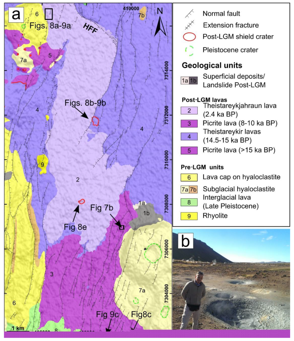
2.2. The Northern Volcanic Zone
3. Methodologies for Image Collection and Processing
3.1. General Overview
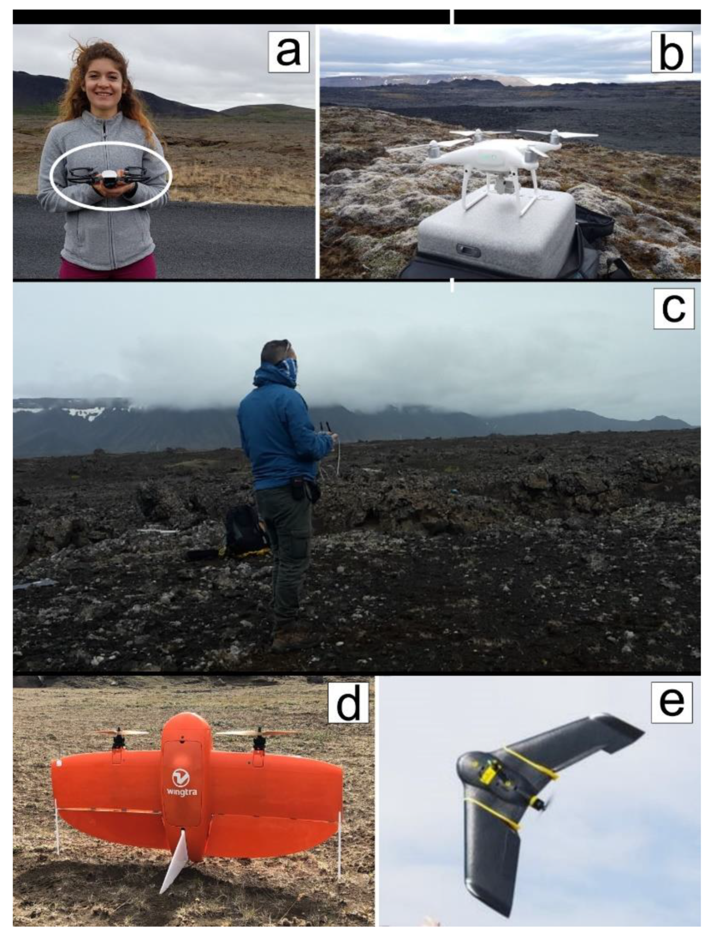
3.2. UAV Selection and Use
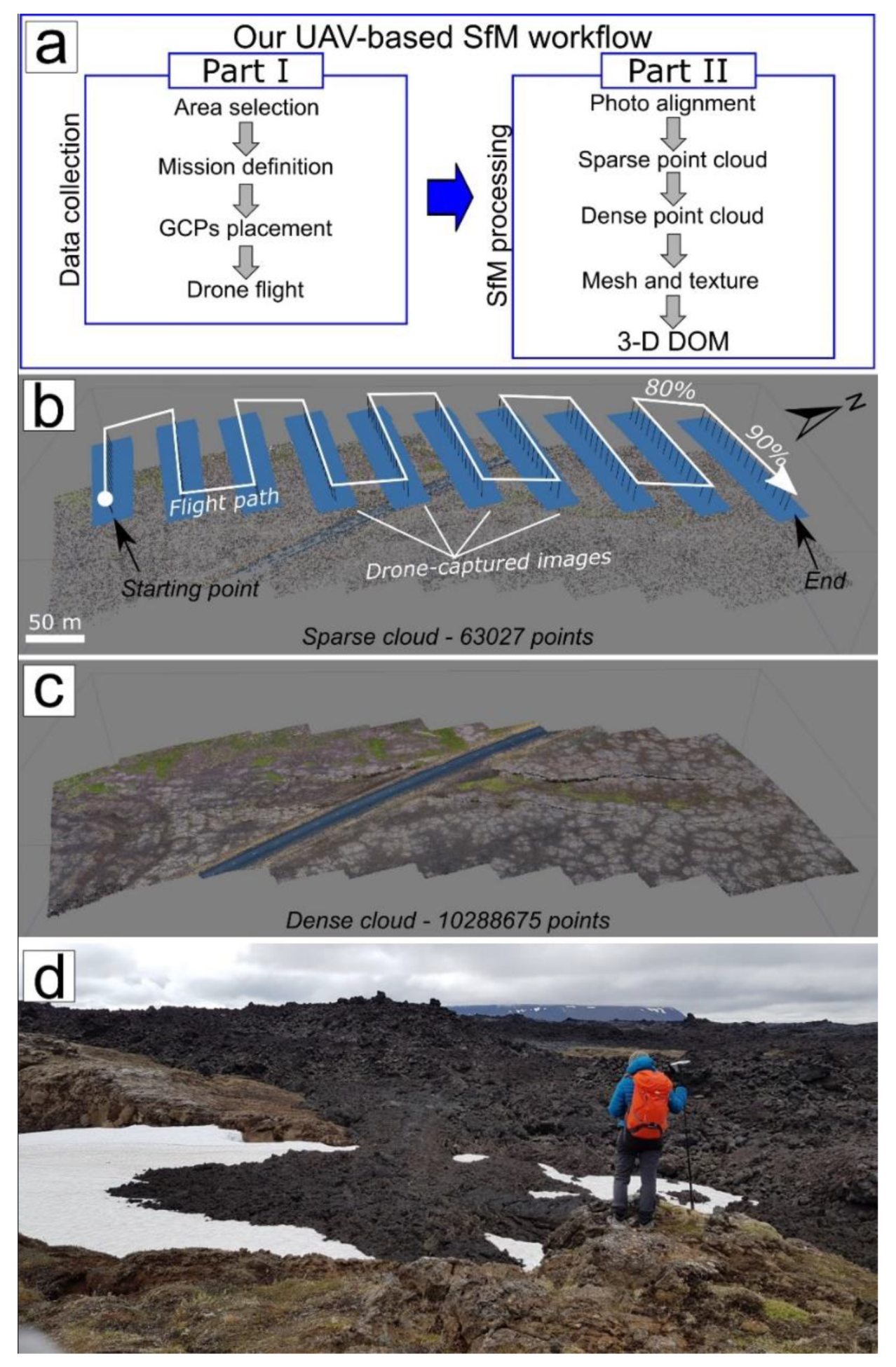
3.3. UAV-Based Structure-from-Motion: Data Collection (Part I)
3.4. UAV-Based Structure-from-Motion: Data Processing and Model Reconstruction (Part II)
4. Geosites in the Two Selected Icelandic Areas: Description and Assessment
4.1. Geosites in the Snæfellsnes Peninsula
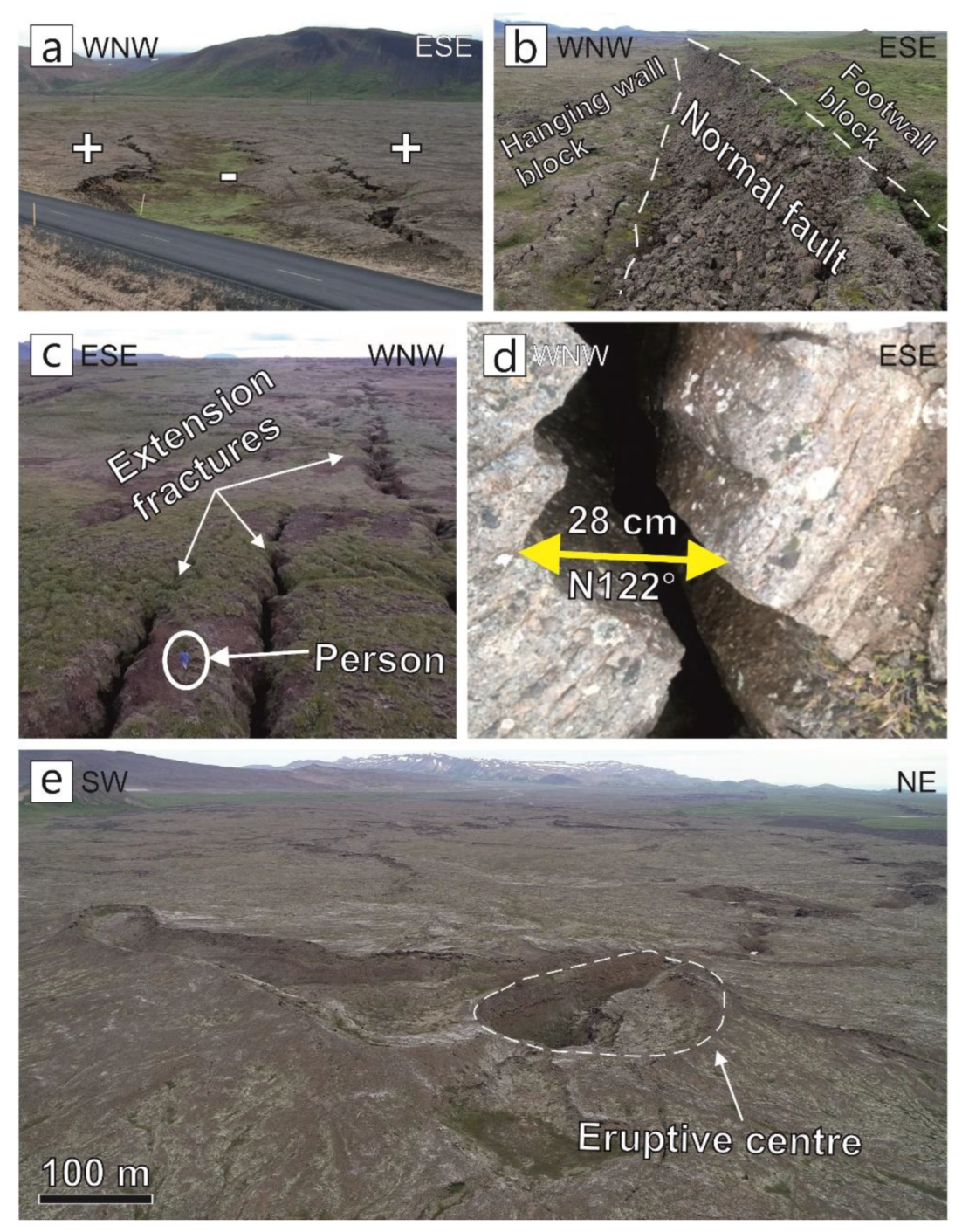
4.2. Geosites in the Northern Volcanic Zone
5. Discussion
5.1. Geosite Assessment
5.2. Geosite Visualization, Fruition and Communication
6. Conclusions
Author Contributions
Funding
Acknowledgments
Conflicts of Interest
References
- Eberhard, R. Pattern and Process: Towards a Regional Approach to National Estate Assessment of Geodiversity; Technical Series No. 2; Eberhard, R., Ed.; Australian Heritage Commission and Environment Forest Taskforce: Canberra, Australian; Environment Australia: Canberra, Australian, 1997. [Google Scholar]
- Brocx, M.; Semeniuk, V. Geoheritage and geoconservation history, definition, scope and scale. J. R. Soc. West. Aust. 2007, 90, 53–87. [Google Scholar]
- Asrat, A.; Demissie, M.; Mogessie, A. Geoheritage conservation in Ethiopia: The case of the Simien mountains. Quaest. Geogr. 2012, 31, 7–23. [Google Scholar] [CrossRef]
- Fassoulas, C.; Mouriki, D.; Dimitriou-Nikolakis, P.; Iliopoulos, G. Quantitative assessment of geotopes as an effective tool for geoheritage management. Geoheritage 2012, 4, 177–193. [Google Scholar] [CrossRef]
- Wimbledon, W.A.P.; Smith-Meyer, S. Geoheritage in Europe and Its Conservation; Wimbledon, W.A.P., Smith-Meyer, S., Eds.; ProGEO: Oslo, Noruega, 2012; p. 405. [Google Scholar]
- Bruno, D.E.; Crowley, B.E.; Gutak, J.M.; Moroni, A.; Nazarenko, O.V.; Oheim, K.B.; Ruban, D.A.; Tiess, G.; Zorina, S.O. Paleogeography as geological heritage: Developing geosite classification. Earth Sci. Rev. 2014, 138, 300–312. [Google Scholar] [CrossRef]
- Brilha, J. Inventory and quantitative assessment of geosites and geodiversity sites: A review. Geoheritage 2016, 8, 119–134. [Google Scholar] [CrossRef]
- Dudley, N. Guidelines for Applying Protected Area Management Categories; Dudley, N., Ed.; IUCN: Gland, Switzerland, 2008. [Google Scholar]
- Reis, J.; Póvoas, L.; Barriga, F.J.A.S.; Lopes, C. Science education in a museum: Enhancing Earth Sciences literacy as a way to enhance public awareness of geological heritage. Geoheritage 2014, 6, 217–223. [Google Scholar] [CrossRef]
- Pasquaré Mariotto, F.; Venturini, C. Strategies and tools for improving Earth Science education and popularization in museums. Geoheritage 2017, 9, 187–194. [Google Scholar] [CrossRef]
- Venturini, C.; Pasquaré Mariotto, F. Geoheritage promotion through an interactive exhibition: A case study from the Carnic Alps, NE Italy. Geoheritage 2019, 11, 459–469. [Google Scholar] [CrossRef]
- De Grosbois, A.M.; Eder, W. Geoparks—A tool for education, conservation and recreation. Environ. Geol. 2008, 55, 465–466. [Google Scholar] [CrossRef]
- Mckeever, P.; Zouros, N.; Patzak, M. The UNESCO global network of national geoparks. In Geotourism. The Tourism of Geology and Landscape; Newsome, D., Dowling, R.K., Eds.; Goodfellow Publishers Ltd.: Oxford, UK, 2010; pp. 221–230. [Google Scholar]
- Pásková, M.; Zelenka, J. Sustainability management of unesco global geoparks. Sustain. Geosci. Geotourism 2018, 2, 44–64. [Google Scholar] [CrossRef]
- Panizza, M.; Piacente, S. Geomorphosites and geotourism. Revista Geográfica Acadêmica 2008, 2, 5–9. [Google Scholar]
- Newsome, D.; Dowling, R.K. Geotourism: The tourism of Geology and Landscape; Goodfellow Publishers Ltd.: Oxford, UK, 2010. [Google Scholar]
- Burek, C.V. The role of LGAPs (Local Geodiversity Action Plans) and Welsh RIGS as local drivers for geoconservation within geotourism in Wales. Geoheritage 2012, 4, 45–63. [Google Scholar] [CrossRef]
- Kubalíková, L. Geomorphosite assessment for geotourism purposes. Czech J. Tour. 2013, 2, 80–104. [Google Scholar] [CrossRef]
- Suzuki, A.; Takagi, H. Evaluation of geosite for sustainable planning and management in Geotourism. Geoheritage 2018, 10, 123–135. [Google Scholar] [CrossRef]
- Cleal, C.J. Geoconservation—What on Earth are we doing? In Regional Conference on Geoconservation: Geological Heritage in the South-European Europe Book of Abstracts; Hlad, B., Herlec, U., Eds.; Environmnetal Agency of the Republic of Slovenia: Ljubljana, Slovenia, 2007; p. 25. Available online: http://arsis.net/circular/ProGEO-Abstract.pdf (accessed on 22 February 2010).
- Burek, C.V.; Prosser, C.D. The History of Geoconservation: An introduction. Geol. Soc. London Spec. Pub. 2008, 300, 1–5. [Google Scholar] [CrossRef]
- Prosser, C.; Murphy, M.; Larwood, J. Geological Conservation: A Guide to Good Practice; English Nature: Peterborough, UK, 2011. [Google Scholar]
- Prosser, C.D. Our rich and varied geoconservation portfolio: The foundation for the future. Proc. Geol. Assoc. 2013, 124, 568–580. [Google Scholar] [CrossRef]
- Gordon, J.E. Geoheritage, Geotourism and the cultural landscape: Enhancing the visitor experience and promoting geoconservation. Geosciences 2018, 8, 136. [Google Scholar] [CrossRef]
- Reynard, E. Geosite. In Encyclopedia of Geomorphology; Goudie, A.S., Ed.; Routledge: London, UK, 2004. [Google Scholar]
- Ruban, D.A. Quantification of geodiversity and its loss. Proc. Geol. Assoc. 2010, 121, 326–333. [Google Scholar] [CrossRef]
- Ruban, D.A.; Kuo, I. Essentials of geological heritage site (geosite) management: A conceptual assessment of interests and conflicts. Nat. Nascosta 2010, 41, 16–31. [Google Scholar]
- Crofts, R.; Gordon, J.E. Geoconservation in protected areas. In Protected Area Governance and Management; Worboys, G.L., Lockwood, M., Kothari, A., Feary, S., Pulsford, I., Eds.; ANU Press: Canberra, Australia, 2015; pp. 531–568. [Google Scholar]
- Grandgirard, V. L’évaluation des géotopes. Geol. Insubr. 1999, 4, 59–66. [Google Scholar]
- Zorina, S.O.; Silantiev, V.V. Geosites, classification of. In Encyclopedia of Mineral and Energy Policy; Springer: Berlin/Heidelberg, Germany, 2014. [Google Scholar] [CrossRef]
- Lima, F.; Brilha, J.; Salamuni, E. Inventorying geological heritage in large territories: A methodological proposal applied to Brazil. Geoheritage 2010, 2, 91–99. [Google Scholar] [CrossRef]
- Reynard, E.; Fontana, G.; Kozlik, L.; Scapozza, C. A method for assessing “scientific” and “additional values” of geomorphosites. Geogr. Helv. 2007, 62, 148–158. [Google Scholar] [CrossRef]
- Coratza, P.; Giusti, C. Methodological proposal for the assessment of the scientific quality of of geomorphosites. Il Quat. 2005, 18, 307–313. [Google Scholar]
- Coratza, P.; Panizza, M. (Eds.) Geomorphology and Cultural Heritage; Memorie Descrittive Della Carta Geologica d’Italia; ISPRA: Rome, Italy, 2009; p. 87. [Google Scholar]
- Ólafsdóttir, R.; Tverijonaite, E. Geotourism: A systematic literature review. Geosciences 2018, 8, 234. [Google Scholar] [CrossRef]
- Ólafsdóttir, R.; Dowling, R. Geotourism and Geoparks. A tool for geoconservation and rural development in vulnerable environments: A case study from Iceland. Geoheritage 2014, 6, 71–87. [Google Scholar] [CrossRef]
- Ásbjörnsdóttir, L. The VIII international ProGEO symposium in reykjavík, 2015. Geoheritage 2018, 10, 139–142. [Google Scholar] [CrossRef]
- Einarsson, P.; Sæmundsson, K. Earthquake epicenters 1982–1985 and volcanic systems in Iceland: A map. In Í Hlutarins Eðli, Festschriftfor Þorbjörn Sigurgeirsson; Menningarsjóður, R., Sigfússon, Þ., Eds.; Menningarsjodur: Reykjavik, Iceland, 1987. [Google Scholar]
- Bonali, F.L.; Tibaldi, A.; Marchese, F.; Fallati, L.; Russo, E.; Corselli, C.; Savini, A. UAV-based surveying in volcano-tectonics: An example from the Iceland rift. J. Struct. Geol. 2019, 121, 46–64. [Google Scholar] [CrossRef]
- Fallati, L.; Polidori, A.; Salvatore, C.; Saponari, L.; Savini, A.; Galli, P. Anthropogenic Marine Debris assessment with Unmanned Aerial Vehicle imagery and deep learning: A case study along the beaches of the Republic of Maldives. Sci. Total Environ. 2019, 693, 133581. [Google Scholar] [CrossRef]
- Jacoby, W.; Gudmundsson, A. Hotspot iceland: An introduction. J. Geodyn. 2007, 43, 1–5. [Google Scholar] [CrossRef]
- Einarsson, P. Plate boundaries, rifts and transforms in Iceland. Jokull 2008, 58, 35–58. [Google Scholar]
- Jakobsdóttir, S.S.; Roberts, M.J.; Guðmundsson, G.B.; Geirsson, H.; Slunga, R. Earthquake swarms at Upptyppingar, North-east Iceland: A sign of magma intrusion? Stud. Geophys. Geod. 2008, 52, 513–528. [Google Scholar]
- Mjelde, R.; Digranes, P.; van Schaack, M.; Shimamura, H.; Shiobara, H.; Kodaira, S.; Næss, O. Crustal structure of the outer Vøring Plateau, offshore Norway, from ocean bottom seismic and gravity data. J. Geophys. Res. 2001, 106, 6769–6791. [Google Scholar] [CrossRef]
- Gudmundsson, A. Dynamics of volcanic systems in Iceland: Example of tectonism and volcanism at juxtaposed hot spot and mid-ocean ridge systems. Ann. Rev. Earth Planet. Sci. 2000, 28, 107–140. [Google Scholar] [CrossRef]
- Flude, S.; Burgess, R.; McGarvie, D.W. Silicic volcanism at Ljósufjöll, Iceland: Insights into evolution and eruptive history from Ar–Ar dating. J. Volcanol. Geotherm. 2008, 169, 154–175. [Google Scholar] [CrossRef]
- Tibaldi, A.; Bonali, F.L.; Pasquaré Mariotto, F.; Rust, D.; Cavallo, A.; D’Urso, A. Structure of regional dykes and local cone sheets in the Midhyrna-Lysuskard area, Snaefellsnes Peninsula (NW Iceland). Bull. Volcanol. 2013, 75, 764–780. [Google Scholar] [CrossRef]
- Young, K.D.; Jancin, B.; Orkan, N.I. Transform deformation of tertiary rocks along the Tjornes Fracture Zone, North Central Iceland. J. Geophys. Res. 1985, 90, 9986–10010. [Google Scholar] [CrossRef]
- Bergerat, F.; Angelier, J. Immature and mature transform zones near a hot spot: The South Iceland Seismic Zone and the Tjornes Fracture Zone (Iceland). Tectonophysics 2008, 447, 142–154. [Google Scholar] [CrossRef]
- Opheim, J.O.; Gudmundsson, A. Formation and geometry of fractures, and related volcanism, of the Krafla fissure swarm, northeast Iceland. Geol. Soc. Am. Bull. 1989, 101, 1608–1622. [Google Scholar] [CrossRef]
- Garcia, S.; Dhont, D. Structural analysis of the Húsavík-Flatey Transform Fault and its relationships with the rift system in Northern Iceland. Geodin. Acta 2005, 18, 31–41. [Google Scholar] [CrossRef]
- Slater, L.; McKenzie, D.; Gronvold, K.; Shimizu, N. Melt generation and movement under Theistareykir, NE Iceland. J. Petrol. 2001, 42, 321–354. [Google Scholar] [CrossRef]
- Stracke, A.; Zindler, A.; Salters, V.J.M.; McKenzie, D.; Blichert-Toft, J.; Albarède, F.; Gronvold, K. Theistareykir revisited. Geochem. Geophys. Geosyst. 2003, 4, 8507. [Google Scholar] [CrossRef]
- Tibaldi, A.; Bonali, F.L.; Einarsson, P.; Hjartardóttir, Á.R.; Pasquarè Mariotto, F.A. Partitioning of Holocene kinematics and interaction between the Theistareykir Fissure Swarm and the Husavik-Flatey Fault, North Iceland. J. Struct. Geol. 2016, 83, 134–155. [Google Scholar] [CrossRef]
- Bonali, F.L.; Tibaldi, A.; Pasquaré Mariotto, F.; Saviano, D.; Meloni, A.; Sajovitz, P. Geometry, oblique kinematics and extensional strain variation along a diverging plate boundary: The example of the northern Theistareykir Fissure Swarm, NE Iceland. Tectonophysics 2019, 756, 57–72. [Google Scholar] [CrossRef]
- Metzger, S.; Jonsson, S.; Danielsen, G.; Hreinsdottir, S.; Jouanne, F.; Giardini, D.; Villemin, T. Present kinematics of the Tjornes Fracture Zone, North Iceland, from campaign and continuous GPS measurements. Geophys. J. Int. 2013, 192, 441–455. [Google Scholar] [CrossRef]
- Gudmundsson, A. Infrastructure and evolution of ocean-ridge discontinuities in Iceland. J. Geodyn. 2007, 43, 6–29. [Google Scholar] [CrossRef]
- Gudmundsson, A.; Brynjolfsson, S.; Jonsson, M.T. Structural analysis of a transform fault-rift zone junction in North Iceland. Tectonophysics 1993, 220, 205–221. [Google Scholar] [CrossRef]
- Fjäder, K.; Gudmundsson, A.; Forslund, T. Dikes, minor faults and mineral veins associated with a transform fault in North Iceland. J. Struct. Geol. 1994, 16, 109–119. [Google Scholar] [CrossRef]
- Magnúsdòttir, S.; Brandsdòttir, B. 2011. Tectonics of the þeistareykir fissure swarm. Jokull 2011, 61, 65–79. [Google Scholar]
- Pasquaré Mariotto, F.; Bonali, F.L.; Tibaldi, A.; Rust, D.; Oppizzi, P.; Cavallo, A. Holocene displacement field at an emerged oceanic transform-ridge junction: The Husavik-Flatey Fault—Gudfinnugja Fault system, North Iceland. J. Struct. Geol. 2015, 75, 118–134. [Google Scholar] [CrossRef]
- Tibaldi, A.; Bonali, F.L.; Pasquaré Mariotto, F.A. Interaction between transform faults and rift systems: A combined field and experimental approach. Front. Earth Sci. 2016, 4, 33. [Google Scholar] [CrossRef]
- Tibaldi, A.; Bonali, F.L.; Pasquaré Mariotto, F.A.; Russo, E. Interplay between inherited rift faults and transcurrent structures: Insights from analogue models and field data from Iceland. Glob. Planet. Chang. 2018, 171, 88–109. [Google Scholar] [CrossRef]
- Tibaldi, A.; Bonali, F.L.; Pasquaré Mariotto, F.A.; Ranieri Tenti, L.M. The development of divergent margins: Insights from the North Volcanic Zone, Iceland. Earth Planet. Sci. Lett. 2019, 509, 1–8. [Google Scholar] [CrossRef]
- Jordan, B.R. A bird’s-eye view of geology: The use of micro drones/UAVs in geologic fieldwork and education. Geol. Soc. Am. Today 2015, 25, 50–52. [Google Scholar] [CrossRef]
- Pavlis, T.L.; Mason, K.A. The new world of 3D geologic mapping. Geol. Soc. Am. Today 2017, 27, 4–10. [Google Scholar] [CrossRef]
- Zekkos, D.; Manousakis, J.; Athanasopoulos-Zekkos, A.; Clark, M.; Knoper, L.; Massey, C.; Archibald, G.; Greenwood, W.; Hemphill-Haley, M.; Rathje, E.; et al. Structure-from-Motion based 3D mapping of landslides & fault rupture sites during 2016 Kaikoura earthquake reconnaissance. In Proceedings of the 11th U.S. National Conference on Earthquake Engineering, Integrating Science, Engineering & Policy, Los Angeles, CA, USA, 25–29 June 2018. [Google Scholar]
- Yao, Y.; Chen, J.; Li, T.; Fu, B.; Wang, H.; Li, Y.; Jia, H. Soil liquefaction in seasonally frozen ground during the 2016 Mw6. 6 Akto earthquake. Soil Dyn. Earthq. Eng. 2019, 117, 138–148. [Google Scholar] [CrossRef]
- Gong, J.H.; Wang, D.C.; Li, Y.; Zhang, L.H.; Yue, Y.J.; Zhou, J.P.; Song, Y.Q. Earthquake induced geological hazard detection under hierarchical stripping classification framework in the Beichuan area. Landslides 2010, 7, 181–189. [Google Scholar] [CrossRef]
- Rathje, E.M.; Franke, K. Remote sensing for geotechnical earthquake reconnaissance. Soil Dyn. Earthq. Eng. 2016, 91, 304–316. [Google Scholar] [CrossRef]
- Brook, M.S.; Merkle, J. Monitoring active landslides in the Auckland region utilising UAV/structure-from-motion photogrammetry. Jpn. Geotech. Soc. Spec. Publ. 2019, 6, 1–6. [Google Scholar] [CrossRef]
- Cignetti, M.; Godone, D.; Wrzesniak, A.; Giordan, D. Structure from motion multisource application for landslide characterization and monitoring: The champlas du col case study, sestriere, North-Western Italy. Sensors 2019, 19, 2364. [Google Scholar] [CrossRef]
- Warrick, J.A.; Ritchie, A.C.; Schmidt, K.M.; Reid, M.E.; Logan, J. Characterizing the catastrophic 2017 Mud Creek landslide, California, using repeat structure-from-motion (SfM) photogrammetry. Landslides 2019, 16, 1201–1219. [Google Scholar] [CrossRef]
- Müller, D.; Walter, T.R.; Schöpa, A.; Witt, T.; Steinke, B.; Gudmundsson, M.T.; Dürig, T. High-resolution digital elevation modeling from TLS and UAV campaign reveals structural complexity at the 2014/2015 holuhraun eruption site, Iceland. Front. Earth Sci. 2017, 5, 59. [Google Scholar] [CrossRef]
- Darmawan, H.; Walter, T.R.; Brotopuspito, K.S.; Nandaka, I.G.M.A. Morphological and structural changes at the Merapi lava dome monitored in 2012–2015 using unmanned aerial vehicles (UAVs). J. Volcanol. Geotherm. Res. 2018, 349, 256–267. [Google Scholar] [CrossRef]
- Favalli, M.; Fornaciai, A.; Nannipieri, L.; Harris, A.; Calvari, S.; Lormand, C. UAV-based remote sensing surveys of lava flow fields: A case study from Etna’s 1974 channel-fed lava flows. Bull. Volcanol. 2018, 80, 29. [Google Scholar] [CrossRef]
- De Beni, E.; Cantarero, M.; Messina, A. UAVs for volcano monitoring: A new approach applied on an active lava flow on Mt. Etna (Italy), during the 27 February–02 March 2017 eruption. J. Volcanol. Geotherm. Res. 2019, 369, 250–262. [Google Scholar] [CrossRef]
- Hashemi-Beni, L.; Jones, J.; Thompson, G.; Johnson, C.; Gebrehiwot, A. Challenges and Opportunities for UAV-based digital elevation model generation for flood-risk management: A case of Princeville, North Carolina. Sensors 2018, 18, 3843. [Google Scholar] [CrossRef]
- Langhammer, J.; Vackova, T. Detection and mapping of the geomorphic effects of flooding using UAV photogrammetry. Pure Appl. Geophys. 2018, 175, 3223–3245. [Google Scholar] [CrossRef]
- Johnson, K.; Nissen, E.; Saripalli, S.; Arrowsmith, J.R.; McGarey, P.; Scharer, K.; Williams, P.; Blisniuk, K. Rapid mapping of ultrafine fault zone topography with structure from motion. Geosphere 2014, 10, 969–986. [Google Scholar] [CrossRef]
- Angster, S.; Wesnousky, S.; Huang, W.L.; Kent, G.; Nakata, T.; Goto, H. Application of UAV photography to refining the slip rate on the Pyramid Lake fault zone, Nevada. Bull. Seismol. Soc. Am. 2016, 106, 2. [Google Scholar] [CrossRef]
- Deffontaines, B.; Chang, K.J.; Champenois, J.; Fruneau, B.; Pathier, E.; Hu, J.-C.; Lu, S.-T.; Liu, Y.C. Active interseismic shallow deformation of the Pingting terraces (Longitudinal Valley–Eastern Taiwan) from UAV high-resolution topographic data combined with InSAR time series. Geomat. Nat. Hazards Risk 2016, 8, 120–136. [Google Scholar] [CrossRef]
- Jiao, Q.; Jiang, W.; Zhang, J.; Jiang, H.; Luo, Y.; Wang, X. Identification of paleoearthquakes based on geomorphological evidence and their tectonic implications for the southern part of the active Anqiu–Juxian fault, eastern China. J. Asian Earth Sci. 2016, 132, 1–8. [Google Scholar] [CrossRef]
- Bi, H.; Zheng, W.; Ren, Z.; Zeng, J.; Yu, J. Using an unmanned aerial vehicle for topography mapping of the fault zone based on structure from motion photogrammetry. Int. J. Remote Sens. 2017, 38, 2495–2510. [Google Scholar] [CrossRef]
- Gao, M.; Xu, X.; Klinger, Y.; van der Woerd, J.; Tapponnier, P. High-resolution mapping based on an Unmanned Aerial Vehicle (UAV) to capture paleoseismic offsets along the Altyn-Tagh fault, China. Sci. Rep. 2017, 7, 8281. [Google Scholar] [CrossRef] [PubMed]
- Wu, F.; Ran, Y.; Xu, L.; Cao, J.; Li, A. Paleoseismological study of the Late Quaternary slip-rate along the South Barkol Basin Fault and its tectonic implications, Eastern Tian Shan, Xinjiang. Acta Geol. Sin. Engl. Ed. 2017, 91, 429–442. [Google Scholar] [CrossRef]
- Rao, G.; He, C.; Cheng, Y.; Yu, Y.; Hu, J.; Chen, P.; Yao, Q. Active normal faulting along the Langshan Piedmont Fault, North China: Implications for slip partitioning in the western Hetao Graben. J. Geol. 2018, 126, 99–118. [Google Scholar] [CrossRef]
- Trippanera, D.; Ruch, J.; Passone, L.; Jónsson, S. Structural mapping of dike-induced faulting in Harrat Lunayyir (Saudi Arabia) by using high resolution drone imagery. Front. Earth Sci. 2019, 7, 168. [Google Scholar] [CrossRef]
- Westoby, M.J.; Brasington, J.; Glasser, N.F.; Hambrey, M.J.; Reynolds, J.M. “Structure-from-Motion” photogrammetry: A low-cost, effective tool for geoscience applications. Geomorphology 2012, 179, 300–314. [Google Scholar] [CrossRef]
- Chesley, J.T.; Leier, A.L.; White, S.; Torres, R. Using unmanned aerial vehicles and structure-from-motion photogrammetry to characterize sedimentary outcrops: An example from the Morrison Formation, Utah, USA. Sediment. Geol. 2017, 354, 1–8. [Google Scholar] [CrossRef]
- James, M.R.; Robson, S.; d’Oleire-Oltmanns, S.; Niethammer, U. Optimising UAV topographic surveys processed with structure-from-motion: Ground control quality, quantity and bundle adjustment. Geomorphology 2017, 280, 51–66. [Google Scholar] [CrossRef]
- Xu, X.; Aiken, C.L.; Nielsen, K.C. Real time and the virtual outcrop improve geological field mapping. Eos Trans. Am. Geophys. Union 1999, 80, 317–324. [Google Scholar] [CrossRef]
- Tavani, S.; Granado, P.; Corradetti, A.; Girundo, M.; Iannace, A.; Arbués, P.; Muñozb, J.A.; Mazzoli, S. Building a virtual outcrop, extracting geological information from it, and sharing the results in Google Earth via OpenPlot and Photoscan: An example from the Khaviz Anticline (Iran). Comput. Geosci. 2014, 63, 44–53. [Google Scholar] [CrossRef]
- Trinks, I.; Clegg, P.; McCaffrey, K.; Jones, R.; Hobbs, R.; Holdsworth, B.; Holliman, N.; Imber, J.; Waggott, S.; Wilson, R. Mapping and analysing virtual outcrops. Vis. Geosci. 2005, 10, 13–19. [Google Scholar] [CrossRef]
- Gerloni, I.G.; Carchiolo, V.; Vitello, F.R.; Sciacca, E.; Becciani, U.; Costa, A.; Riggi, S.; Bonali, F.L.; Russo, E.; Fallati, L.; et al. Immersive virtual reality for earth sciences. In Proceedings of the 2018 Federated Conference on Computer Science and Information Systems (FedCSIS), Poznań, Poland, 9–12 September 2018; IEEE: Piscataway, NJ, USA, 2018; pp. 527–534. [Google Scholar]
- Varvara, A.; Nomikou, P.; Pavlina, B.; Pantelia, S.; Bonali, F.L.; Lemonia, R.; Andreas, M. The Story Map for Metaxa Mine (Santorini, Greece): A unique site where history and volcanology meet each other. In Proceedings of the 5th International Conference on Geographical Information Systems Theory, Applications and Management (GISTAM 2019), Heraklion, Crete, Greece, 3–5 May 2019; pp. 212–219. [Google Scholar]
- Krokos, M.; Bonali, F.L.; Vitello, F.; Antoniou, V.; Becciani, U.; Russo, E.; Marchese, F.; Fallati, L.; Nomikou, P.; Kearl, M.; et al. Workflows for virtual reality visualisation and navigation scenarios in Earth Sciences. In Proceedings of the 5th International Conference on Geographical Information Systems Theory, Applications and Management, GISTAM 2019, Heraklion, Crete, Greece, 3–5 May 2019; pp. 297–304. [Google Scholar]
- Vollgger, S.A.; Cruden, A.R. Mapping folds and fractures in basement and cover rocks using UAV photogrammetry, Cape Liptrap and Cape Paterson, Victoria, Australia. J. Struct. Geol. 2016, 85, 168–187. [Google Scholar] [CrossRef]
- James, M.R.; Robson, S. Straightforward reconstruction of 3D surfaces and topography with a camera: Accuracy and geoscience application. J. Geophys. Res. 2012, 117, F03017. [Google Scholar] [CrossRef]
- Turner, D.; Lucieer, A.; Watson, C. An automated technique for generating georectified mosaics from ultra-high resolution unmanned aerial vehicle (UAV) imagery, based on structure from motion (SfM) point clouds. Remote Sens. 2012, 4, 1392–1410. [Google Scholar] [CrossRef]
- Burns, J.H.R.; Delparte, D. Comparison of commercial structure-from-motion photogrammetry software used for underwater three-dimensional modeling of coral reef environments. Int. Arch. Photogramm. Remote Sens. Spat. Inf. Sci. ISPRS Arch. 2017, 42, 127–131. [Google Scholar] [CrossRef]
- Stal, C.; Bourgeois, J.; De Maeyer, P.; De Mulder, G.; De Wulf, A.; Goossens, R.; Hendrickx, M.; Nuttens, T.; Stichelbaut, B. Test case on the quality analysis of structure from motion in airborne applications. In 32nd EARSeL Symposium: Advances in Geosciences; European Association of Remote Sensing Laboratories (EARSeL): Mykonos, Greece, 2012. [Google Scholar]
- Grandgirard, V. Géomorphologie, protection de la nature et gestion du paysage. Thèse de Doctorat en Géographie, Université de Fribourg, Fribourg, Switzerland, 1997; p. 210. Available online: https://www.persee.fr/doc/karst_0751-7688_2000_num_35_1_2461_t1_0064_0000_2 (accessed on 31 January 2020).
- Kokfelt, T.F.; Hoernle, K.; Lundstrom, C.; Hauff, F.; van den Bogaard, C. Time-scale for magmatic differentiation at the Snaefellsjokull central volcano, western Iceland: Constraints from U-Th-Pa-Ra-disequilibria in post-glacial lavas. Geochem. Cosmochem. Acta 2009, 73, 1120–1144. [Google Scholar] [CrossRef]
- Corazzato, C.; Tibaldi, A. Fracture control on type, morphology and distribution of parasitic volcanic cones: An example from Mt. Etna, Italy. J. Volcanol. Geotherm. Res. 2006, 158, 177–194. [Google Scholar] [CrossRef]
- Bonali, F.L.; Corazzato, C.; Tibaldi, A. Identifying rift zones on volcanoes: An example from La Réunion Island. Indian Ocean. Bull. Volcanol. 2011, 73, 347–366. [Google Scholar] [CrossRef]
- Tibaldi, A.; Bonali, F.L. Intra-arc and back-arc volcano-tectonics: Magma pathways at Holocene Alaska-Aleutian volcanoes. Earth Sci. Rev. 2017, 167, 1–26. [Google Scholar] [CrossRef]
- Gudmundsson, A.; Pasquarè Mariotto, F.A.; Tibaldi, A. Dykes, Sills, Laccoliths, and Inclined Sheets in Iceland. In Physical Geology of Shallow Magmatic Systems; Breitkreutz, C., Rocchi, S., Eds.; Springer: Cham, Germany, 2014. [Google Scholar]
- Scudero, S.; De Guidi, G.; Gudmundsson, A. Size distributions of fractures, dykes, and eruptions on Etna, Italy: Implications for magma-chamber volume and eruption potential. Sci. Rep. 2019, 9, 4139. [Google Scholar] [CrossRef]
- Tibaldi, A.; Pasquaré Mariotto, F.; Papanikolaou, D.; Nomikou, P. Discovery of a huge sector collapse at the Nisyros volcano, Greece, by on-land and offshore geological-structural data. J. Volcanol. Geotherm. Res. 2008, 177, 485–499. [Google Scholar] [CrossRef]
- Pasquaré Mariotto, F.; Tibaldi, A. Structure of a sheet–laccolith system revealing the interplay between tectonic and magma stresses at Stardalur Volcano, Iceland. J. Volcanol. Geotherm. Res. 2007, 161, 131–150. [Google Scholar] [CrossRef]
- Tibaldi, A.; Vezzoli, L.; Pasquaré Mariotto, F.; Rust, D. Strike-slip fault tectonics and the emplacement of sheetelaccolith systems: The Thverfell case study (SW Iceland). J. Struct. Geol. 2008, 30, 274–290. [Google Scholar] [CrossRef]
- Tibaldi, A.; Pasquaré Mariotto, F. A new mode of inner volcano growth: The “flower intrusive structure”. Earth Planet. Sci. Lett. 2008, 271, 202–208. [Google Scholar] [CrossRef]
- Tibaldi, A.; Pasquaré Mariotto, F.; Rust, D. New insights into the cone–sheet structure of the Cuillin Complex, Isle of Skye, Scotland. J. Geol. Soc. 2011, 168, 689–704. [Google Scholar] [CrossRef]
- Bistacchi, A.; Tibaldi, A.; Pasquaré Mariotto, F.; Rust, D. The association of cone-sheets and radial dykes: Data from the Isle of Skye (UK), numerical modelling, and implications for shallow magma chambers. Earth Planet Sci. Lett. 2012, 339–340, 46–56. [Google Scholar] [CrossRef]
- Gianelli, G. Cumulus textures of the Midhyrna layered intrusion. Boll. Soc. Geol. Ital. 1972, 91, 419–438. [Google Scholar]
- Hjartardóttir, A.R.; Einarsson, P.; Bramham, E.; Wright, T.J. The Krafla fissure swarm, Iceland, and its formation by rifting events. Bull. Volcanol. 2012, 74, 2139–2153. [Google Scholar] [CrossRef]
- Thordarson, T.; Larsen, G. Volcanism in Iceland in historical time: Volcano types, eruption styles and eruptive history. J. Geodyn. 2007, 43, 118–152. [Google Scholar] [CrossRef]
- Kubalíková, L. Assessing geotourism resources on a local level: A case study from southern Moravia (Czech Republic). Resources 2019, 8, 150. [Google Scholar] [CrossRef]
- Bonali, F.L.; Tibaldi, A.; Russo, E.; Pasquaré Mariotto, F.; Marchese, F.; Fallati, L.; Savini, A.; Vitello, F.; Becciani, U.; Sciacca, E. Immersive virtual reality for studying volcano-tectonic features: A case study from the northern active rift zone of Iceland. In Geophysical Research Abstracts; EGU2019-1159. EGU General Assembly 2019; EGU: Vienna, Austria, 2019; Volume 21. [Google Scholar]
- Bonali, F.L.; Russo, E.; Savini, A.; Marchese, F.; Fallati, L.; Nomikou, P.; Varvara, A.; Kyriaki, D.; Di Mauro, B.; Colombo, R.; et al. Learning outcomes from the EGU 2018 Public Engagement grant “Shaping geological 3D virtual field-surveys for overcoming motor disabilities”. In Geophysical Research Abstracts; EGU2019-8118, EGU General Assembly 2019; EGU: Vienna, Austria, 2019; Volume 21. [Google Scholar]
- Sketchfab. Available online: https://skfb.ly/6PKqL (accessed on 8 January 2020).
- Sketchfab. Available online: https://skfb.ly/6PKqR (accessed on 8 January 2020).
- Sketchfab. Available online: https://skfb.ly/6PK7U (accessed on 9 January 2020).
- Sketchfab. Available online: https://skfb.ly/6PKqx (accessed on 9 January 2020).
- Sketchfab. Available online: https://skfb.ly/6PK7G (accessed on 11 January 2020).
- Sketchfab. Available online: https://skfb.ly/6PJIM (accessed on 11 January 2020).
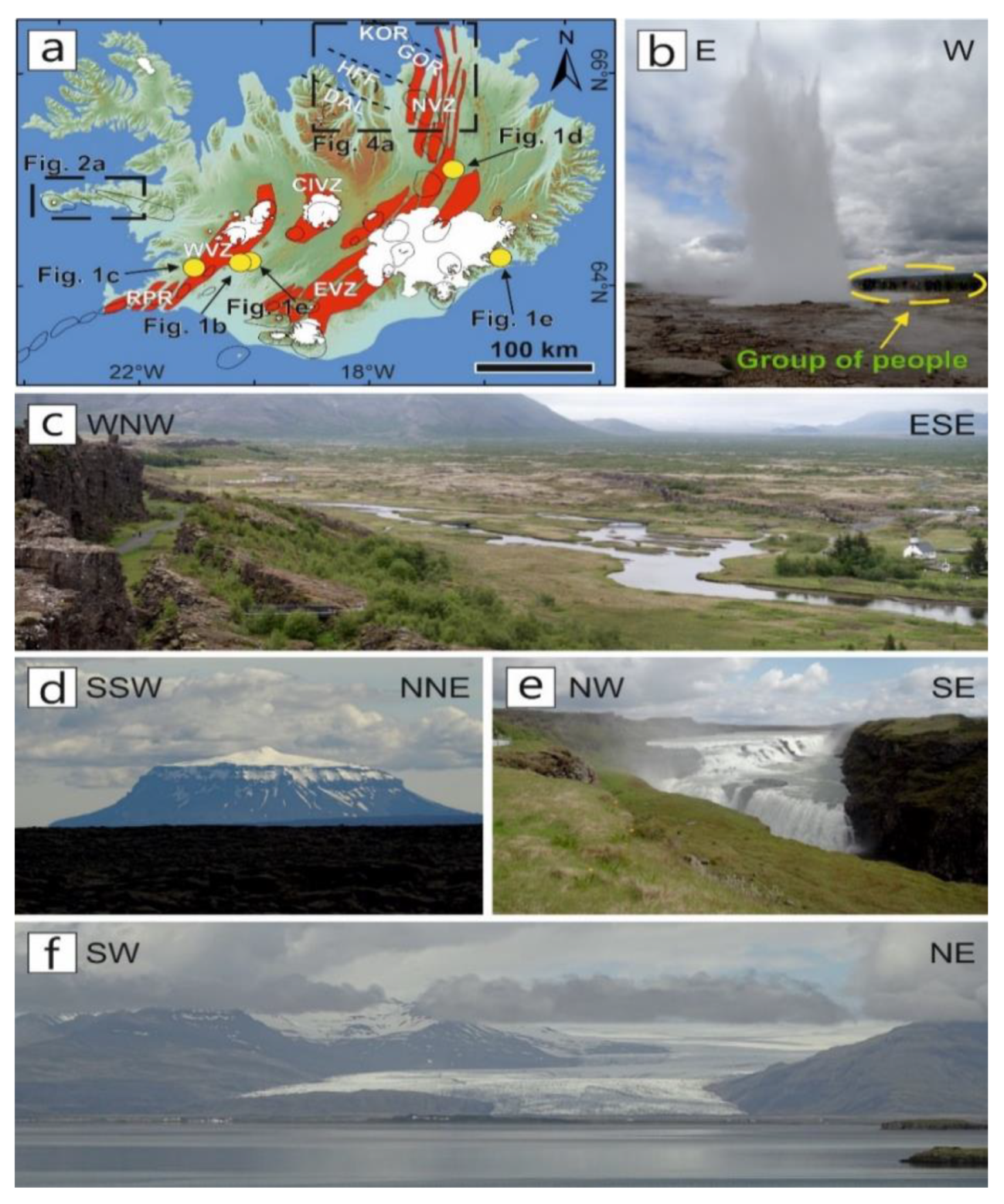
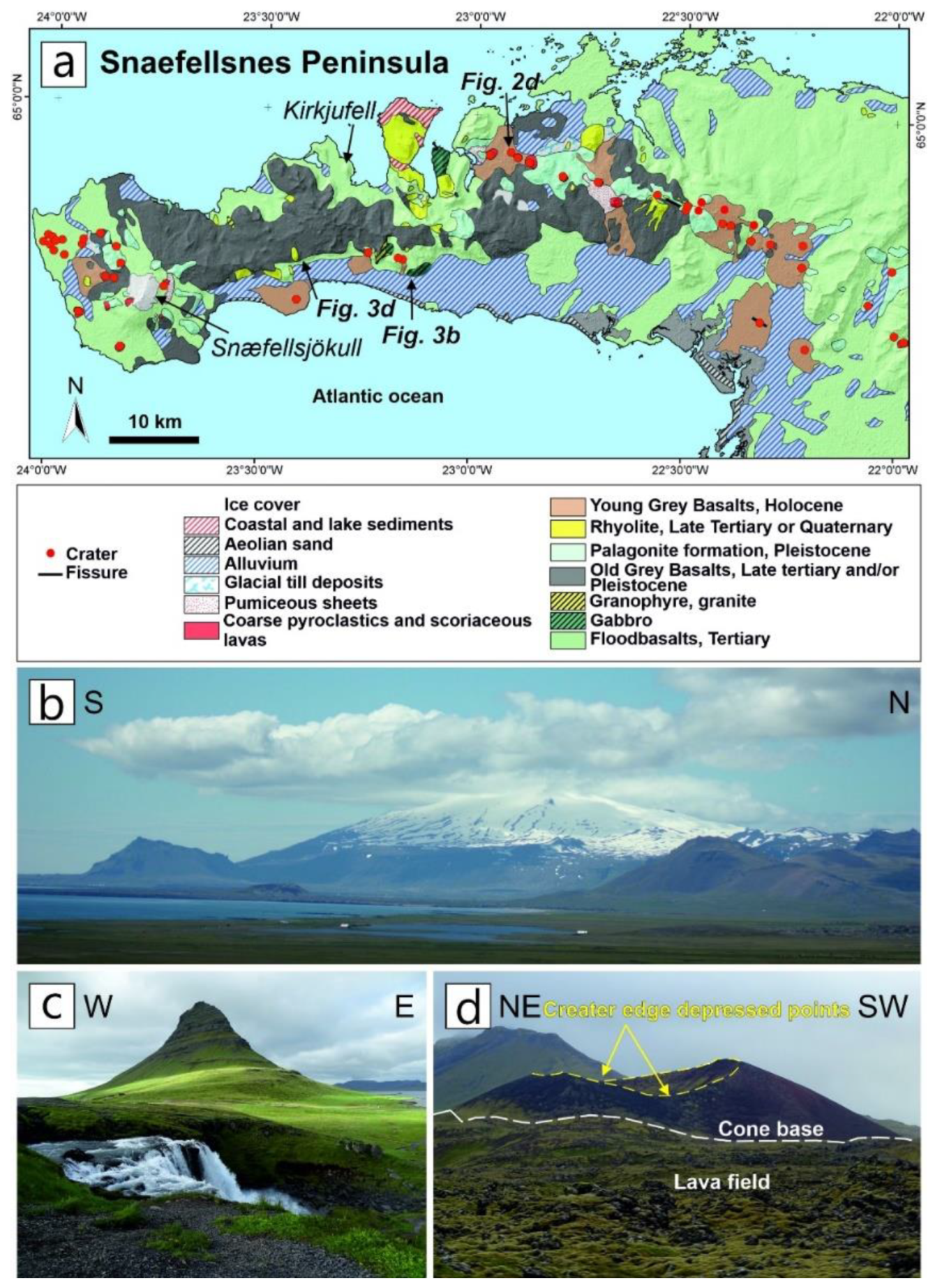
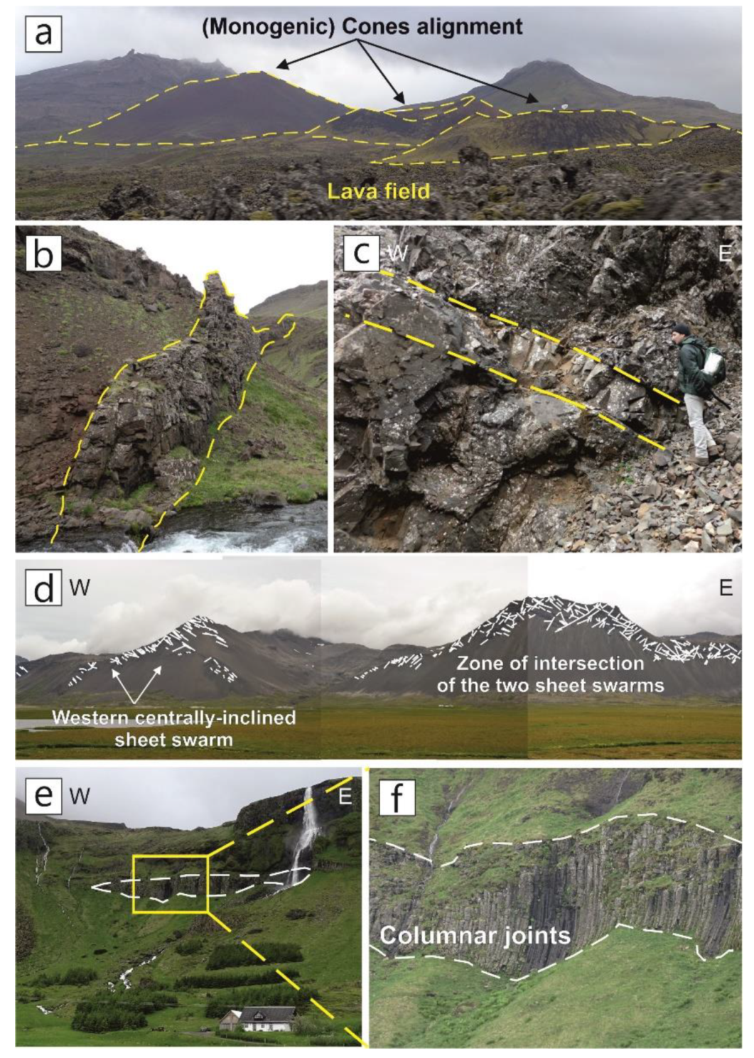
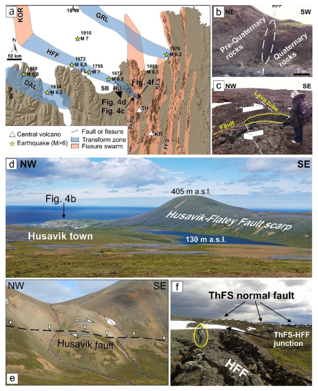
© 2020 by the authors. Licensee MDPI, Basel, Switzerland. This article is an open access article distributed under the terms and conditions of the Creative Commons Attribution (CC BY) license (http://creativecommons.org/licenses/by/4.0/).
Share and Cite
Pasquaré Mariotto, F.; Bonali, F.L.; Venturini, C. Iceland, an Open-Air Museum for Geoheritage and Earth Science Communication Purposes. Resources 2020, 9, 14. https://doi.org/10.3390/resources9020014
Pasquaré Mariotto F, Bonali FL, Venturini C. Iceland, an Open-Air Museum for Geoheritage and Earth Science Communication Purposes. Resources. 2020; 9(2):14. https://doi.org/10.3390/resources9020014
Chicago/Turabian StylePasquaré Mariotto, Federico, Fabio Luca Bonali, and Corrado Venturini. 2020. "Iceland, an Open-Air Museum for Geoheritage and Earth Science Communication Purposes" Resources 9, no. 2: 14. https://doi.org/10.3390/resources9020014
APA StylePasquaré Mariotto, F., Bonali, F. L., & Venturini, C. (2020). Iceland, an Open-Air Museum for Geoheritage and Earth Science Communication Purposes. Resources, 9(2), 14. https://doi.org/10.3390/resources9020014


