Geoheritage as a Tool for Environmental Management: A Case Study in Northern Malta (Central Mediterranean Sea)
Abstract
1. Introduction
2. Maltese Context
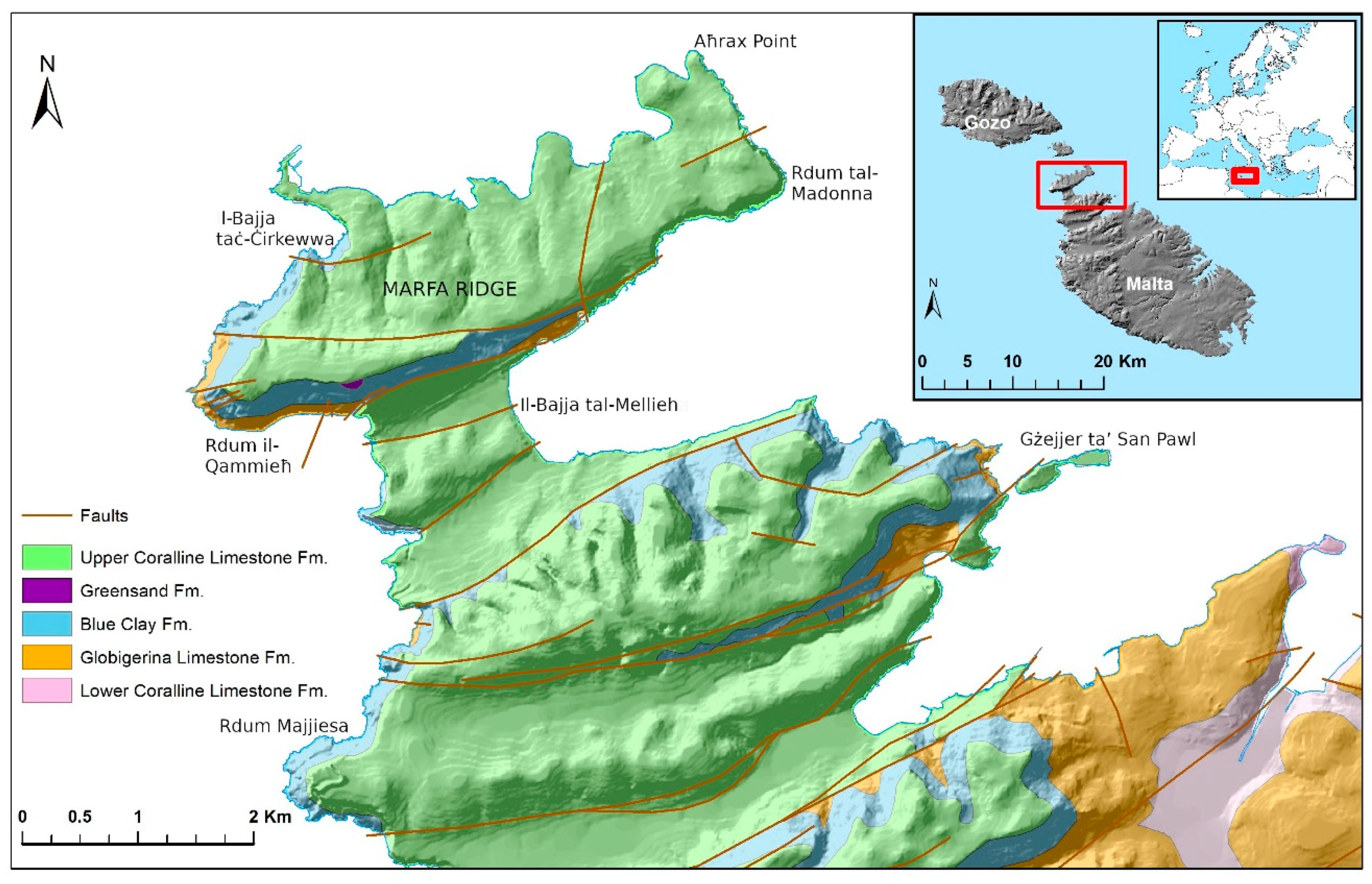
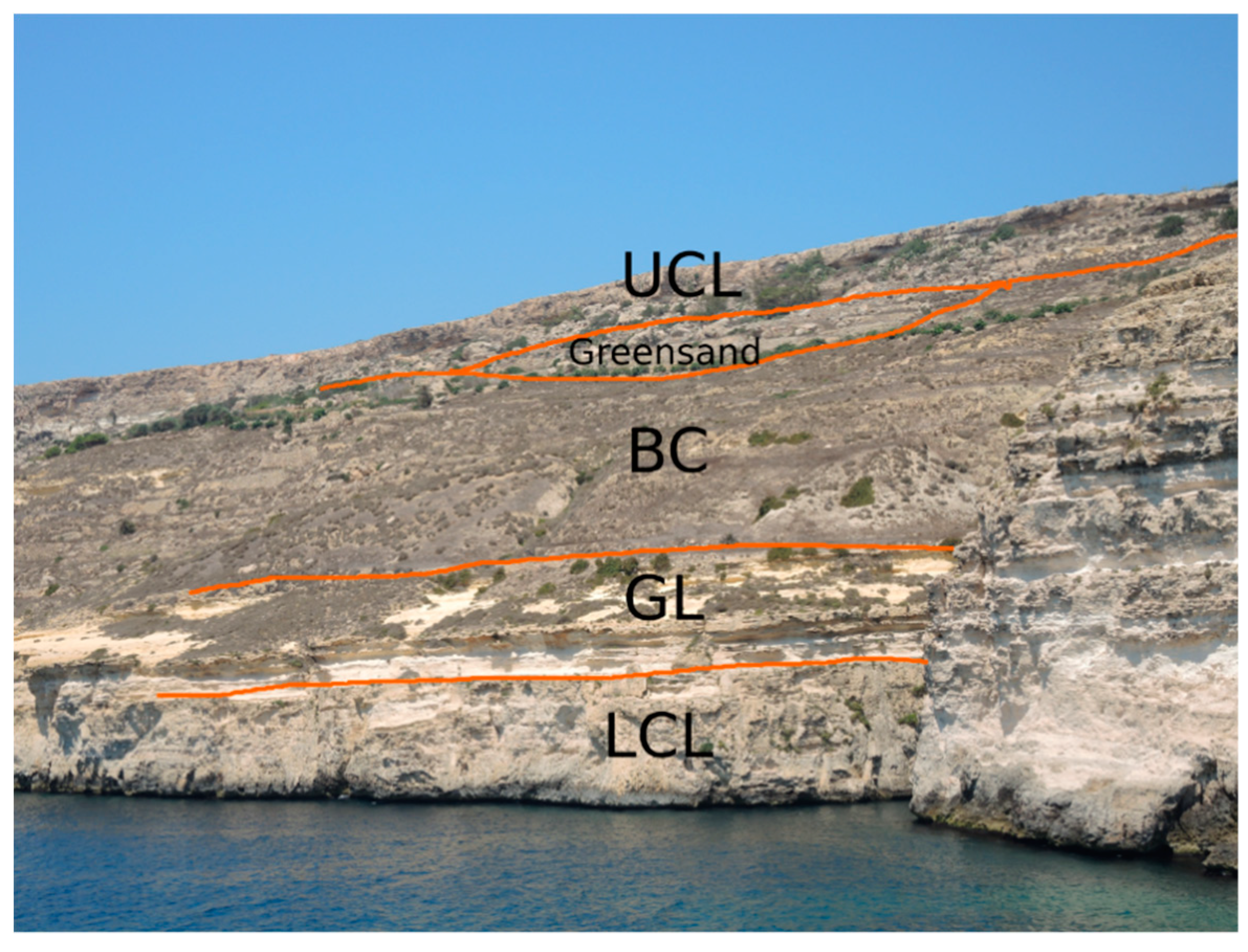
3. Study Area
4. Materials and Methods
4.1. Recognition and Selection of Sites of Geological and Geomorphological Interest
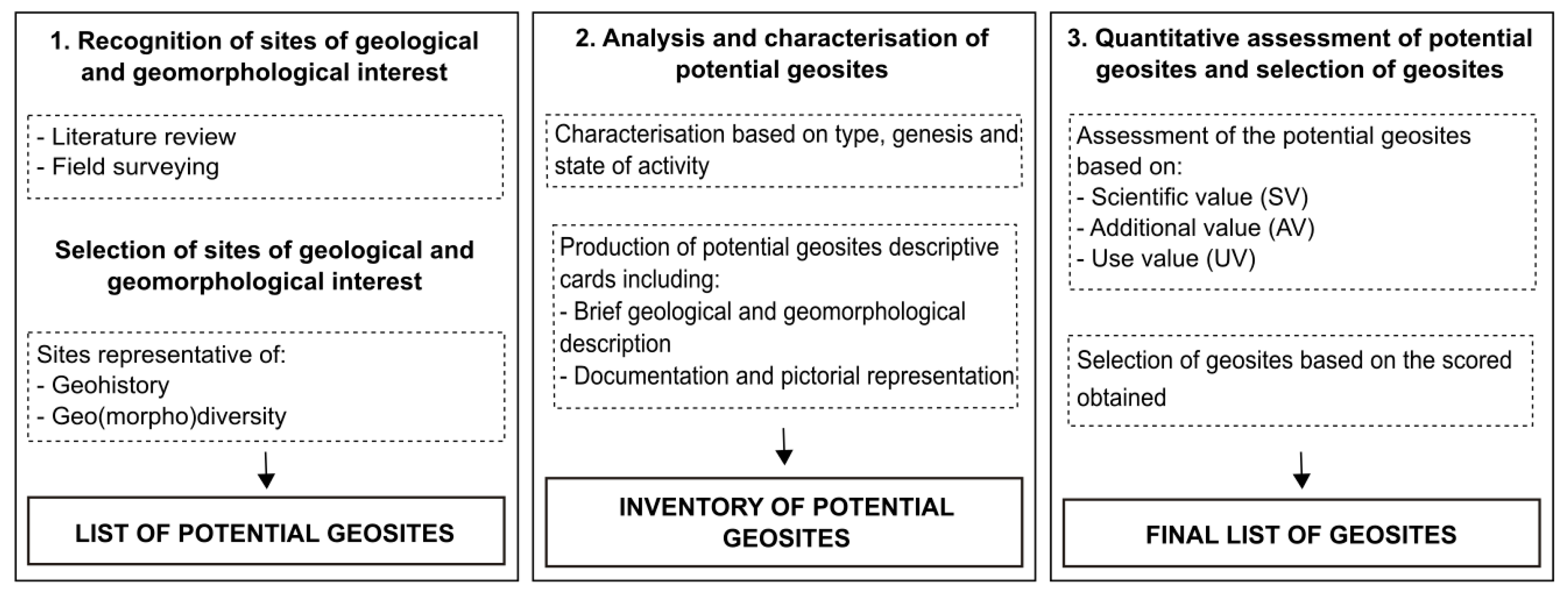
- The sites have to be representative of the geo-history and geomorphological evolution of the study area at a regional scale. Both active and inherited geological and geomorphological features can be considered as potential geosites.
- The sites have to represent the regional geo(morpho)diversity, i.e., a complete set of geomorphological processes that acted over time in the study area. Unique or rare landforms, as well as more common and abundant ones, can be useful to provide an overview of the landforms visible in the area (cf. [12]).
4.2. Analysis and Characterisation of Potential Geosites
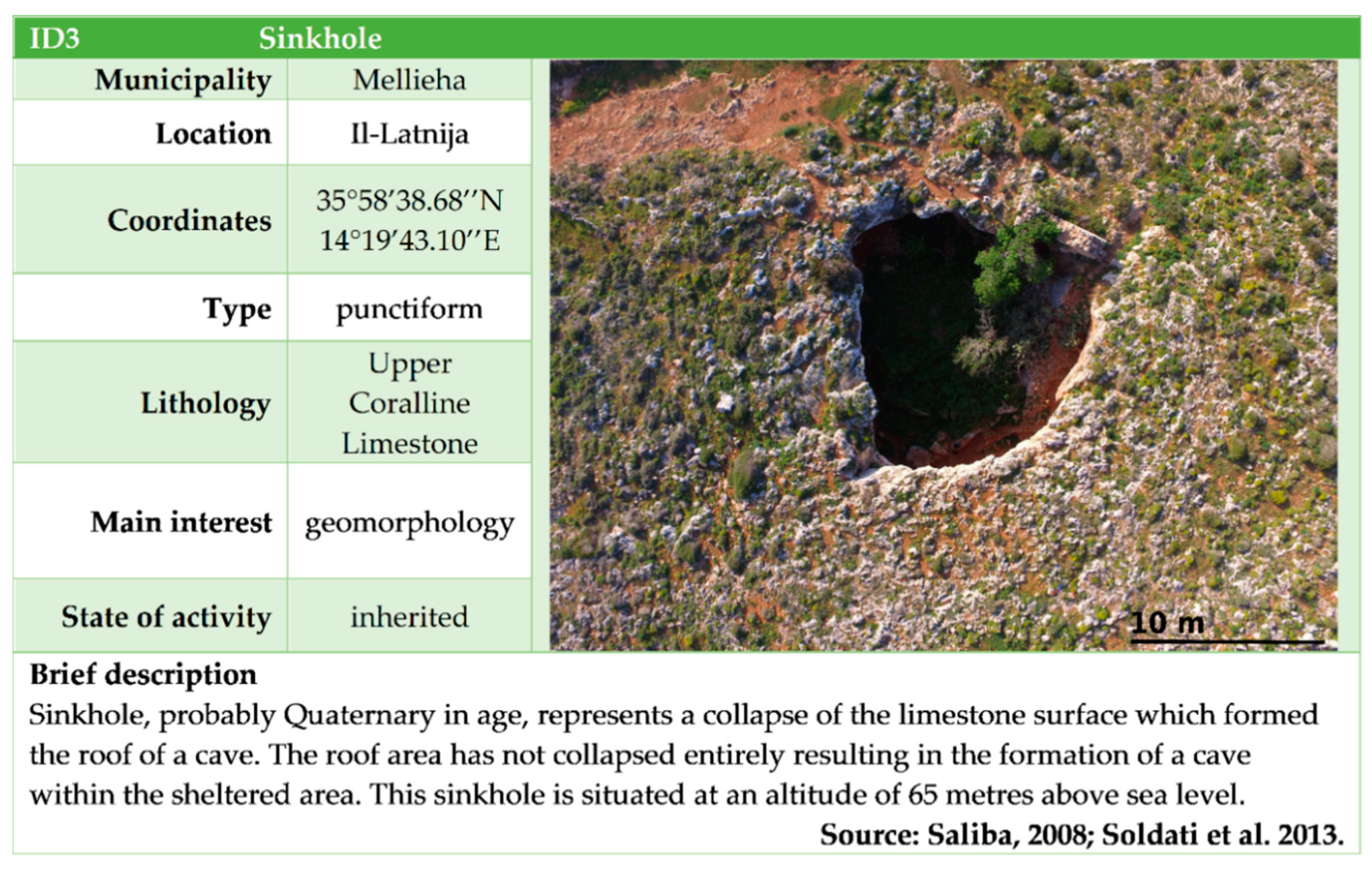
- (1)
- Feature: name of the potential geosite;
- (2)
- Location: as precise as possible;
- (3)
- Coordinates: international system;
- (4)
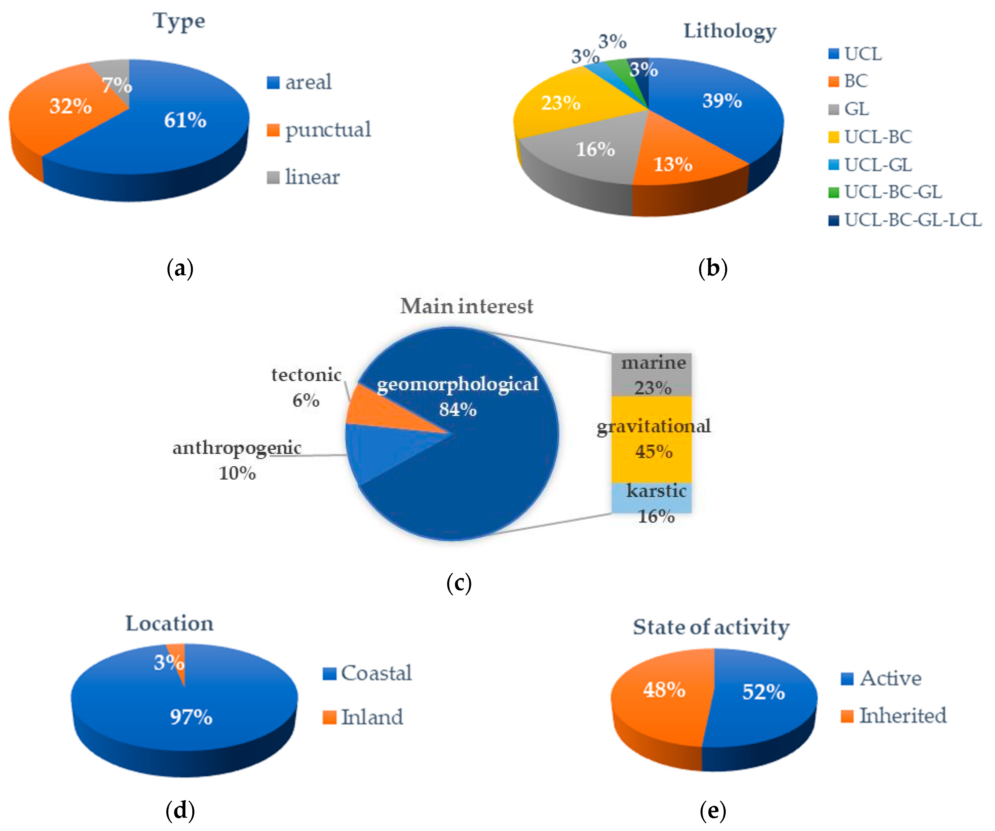
- Type (according to [51,58,60,83,84], distinguished on its geometrical characters in: (i) punctiform, small-size isolated single form or object (e.g., a sinkhole or a spring); (ii) linear, one or more simple forms developed preferentially in a single direction (e.g., a canyon, or a paleo riverbed) and/or stratigraphical sequences; (iii) areal: a set of large simple landforms related to just one type of genetic process (e.g., a karren field);
- (5)
- Lithology;
- (6)
- Genesis/main interest: e.g., tectonic, geomorphological, stratigraphic; regarding the geomorphological interest, a morphogenetic division related to a group of processes (coastal, fluvial, karstic, gravity-induced etc.) can be applied;
- (7)
- State of activity (e.g., [85,86,87,88,89,90,91,92,93]): active sites, those that allow the visualization of geological and geomorphological processes in action (e.g., fluvial systems); inherited sites defined as inherited landforms, which testify to past processes and have a particular heritage value since they are symbols of Earth’s history and evolution (e.g., stack);
- (8)
- Brief geological and geomorphological description based on field observations and literature survey;
- (9)
- Documents, archive material and pictorial representations: e.g., photographs, sketches.
4.3. Quantitative Assessment of Potential Geosites and Selection of Geosites
5. Results
5.1. Recognition and Selection of Sites of Geological and Geomorphological Interest
5.2. Analysis and Characterization of Potential Geosites
5.3. Quantitative Assessment and Selection of Geosites
6. Conclusions
Author Contributions
Funding
Acknowledgments
Conflicts of Interest
References
- Gray, M. Geodiversity—Valuing and Conserving Abiotic Nature, 1st ed.; Wiley, J., Ed.; The Atrium, Southern Gate: Chichester, UK, 2004. [Google Scholar]
- Sharples, C. Concepts and Principles of Geoconservation. Tasmanian Parks & Wildlife Service; PDF Document; Tasmanian Parks and Wildlife Service: Hobart, Australia, 2002. Available online: https://dpipwe.tas.gov.au/Documents/geoconservation.pdf (accessed on 17 October 2019).
- Gray, M. Geodiversity: The backbone of Geoheritage and Geoconservation. In Geoheritage: Assessment, Protection, and Management; Reynard, E., Brilha, J., Eds.; Elsevier: Amsterdam, The Netherland, 2018; pp. 13–25. [Google Scholar]
- Newsome, D.; Dowling, R. Geoheritage and Geotourism. In Geoheritage: Assessment, Protection, and Management; Reynard, E., Brilha, J., Eds.; Elsevier: Amsterdam, The Netherland, 2018; pp. 305–322. [Google Scholar]
- Coratza, P.; Hobléa, F. The Specificities of Geomorphological Heritage. In Geoheritage: Assessment, Protection, and Management; Reynard, E., Brilha, J., Eds.; Elsevier: Amsterdam, The Netherland, 2018; pp. 87–106. [Google Scholar]
- IUGS. Heritage Sites and Collections Subcommission, National Heoheritage Inventories. Available online: https://geoheritage-iugs.mnhn.fr/index.php?catid=19&blogid=1 (accessed on 15 May 2019).
- Coratza, P.; Bruschi, V.M.; Piacentini, D.; Saliba, D.; Soldati, M. Recognition and Assessment of Geomorphosites in Malta at the Il-Majjistral Nature and History Park. Geoheritage 2011, 3, 175–185. [Google Scholar] [CrossRef]
- Coratza, P.; Galve, J.P.; Soldati, M.; Tonelli, C. Recognition and assessment of sinkholes as geosites: Lessons from the Island of Gozo (Malta). Qua. Geor. 2012, 31, 22–35. [Google Scholar] [CrossRef]
- Coratza, P.; Gauci, R.; Schembri, J.A.; Soldati, M.; Tonelli, C. Bridging Natural and Cultural Values of Sites with Outstanding Scenery: Evidence from Gozo, Maltese Islands. Geoheritage 2016, 8, 91–103. [Google Scholar] [CrossRef]
- Agnesi, V.; Angileri, S.E.; Cappadonia, C.; Coratza, P.; Costanzo, D.; Soldati, M.; Tonelli, C. Geositi nel paesaggio mediterraneo: Confronto tra aree costiere maltesi e siciliane. Culture Territori Linguaggi 2014, 4, 1–12. [Google Scholar]
- Gauci, R.; Schembri, J.A.; Inkpen, R. Traditional Use of Shore Platforms: Mapping the Artisanal Management of Coastal Salt Pans on the Maltese Islands (Central Mediterranean). In Traditional Wisdom: Before It’s Too Late; York, K., Ed.; SAGE Open Special Issue; Sage Publications: Thousand Oaks, CA, USA, 2017; Volume 7, pp. 1–16. [Google Scholar]
- Cappadonia, C.; Coratza, P.; Agnesi, V.; Soldati, M. Malta and Sicily Joined by Geoheritage Enhancement and Geotourism within the Framework of Land Management and Development. Geosci. J. 2018, 8, 253. [Google Scholar] [CrossRef]
- Gauci, R.; Schembri, J.A. (Eds.) Landscapes and Landforms of the Maltese Islands; Springer: Cham, Switzerland, 2019. [Google Scholar]
- Spiteri, L.; Stevens, D. Landscape Diversity and Protection in Malta. In Landscapes and Landforms of the Maltese Islands; Gauci, R., Schembri, J.A., Eds.; Springer: Cham, Switzerland, 2019; pp. 359–372. [Google Scholar]
- Environment and Resource Authority (ERA). Database on Designated Areas in National Law. 2018. Available online: https://era.org.mt/en/Pages/Database-on-Designated-Areas-in-National-Law.aspx (accessed on 3 June 2019).
- Soldati, M.; Buhagiar, S.; Coratza, P.; Pasuto, A.; Schembri, J.A. Integration of the geomorphological environment and cultural heritage: A key issue for present and future times. Geogr. Fis. Dinam. Quat. 2008, 31, 95–96. [Google Scholar]
- Soldati, M.; Buhagiar, S.; Coratza, P.; Pasuto, A.; Schembri, J.A. (Eds.) Integration of the geomorphological environment and cultural heritage for tourist promotion and hazard prevention. Geogr. Fis. Dinam. Quat. 2008, 31, 93–247. [Google Scholar]
- May, V. Integrating the geomorphological environmental, cultural heritage, tourism and coastal hazards in practice. Geogr. Fis. Dinam. Quat. 2008, 31, 187–194. [Google Scholar]
- Gauci, R.; Inkpen, R. The physical Characteristics of Limestone Shore Platforms on the Maltese Islands and Their Neglected Contribution to Coastal Land Use Development. In Landscapes and Landforms of the Maltese Islands; Gauci, R., Schembri, J.A., Eds.; Springer: Cham, Switzerland, 2019; Volume 27, pp. 343–356. [Google Scholar]
- Satariano, B.; Gauci, R. Landform Loss and Its Effect on Health and Wellbeing: The collapse of the Azure Window (Gozo) and the Resultant Reactions of the Media and the Maltese Community. In Landscapes and Landforms of the Maltese Islands; Gauci, R., Schembri, J.A., Eds.; Springer: Cham, Switzerland, 2019; Volume 23, pp. 289–303. [Google Scholar]
- Calleja, I.; Tonelli, C. Dwejra and Maqluba: Emblematic sinkholes in the Maltese Islands. In Landscapes and Landforms of the Maltese Islands; Gauci, R., Schembri, J.A., Eds.; Springer: Cham, Switzerland, 2019; Volume 11, pp. 129–139. [Google Scholar]
- Ministry of Tourism. National Tourism Policy 2015–2020. Available online: https://tourism.gov.mt/en/Documents/FINALBOOKLETexport9.pdf (accessed on 17 October 2019).
- Pedley, H.M.; Clarke, M.H.; Galea, P. Limestone Isles in a Crystal Sea. The Geology of the Maltese Islands; PEG Ltd.: San Gwann, Malta, 2002. [Google Scholar]
- Baldassini, N.; Di Stefano, A. Stratigraphic features of the Maltese Archipelago: A synthesis. Nat. Hazards 2017, 86, 203–231. [Google Scholar] [CrossRef]
- Pedley, H.M.; Waugh, B. Easter Field Meeting to the Maltese Islands. Proc. Geol. Assoc. 1976, 87, 343–358. [Google Scholar] [CrossRef]
- Scerri, S. Sedimentary Evolution and Resultant Geological Landscapes. In Landscapes and Landforms of the Maltese Islands; Gauci, R., Schembri, J.A., Eds.; Springer: Cham, Switzerland, 2019; pp. 31–47. [Google Scholar]
- Pedley, H.M.; House, M.R.; Waugh, B. The Geology of the Pelagian Block: The Maltese Islands. In The Ocean Basins and Margins, The Western Mediterranean; Nairn, A.E.M., Kanes, W.H., Stehli, F.G., Eds.; Plenum Press: London, UK, 1978; Volume 4B, pp. 417–433. [Google Scholar]
- Bianucci, G.; Gatt, M.; Catanzariti, R.; Sorbi, S.; Bonavia, C.G.; Curmi, R.; Varola, A. Systematics, biostratigraphy and evolutionary pattern of the Oligo-Miocene marine mammals from the Maltese Islands. Geobios 2011, 44, 549–585. [Google Scholar] [CrossRef]
- Devoto, S.; Biolchi, S.; Bruschi, V.M.; González, D.A.; Mantovani, M.; Pasuto, A.; Soldati, M. Landslides Along the North-West Coast of the Island of Malta. In Landslide Science and Practice: Landslide Inventory and Susceptibility and Hazard Zoning; Margottini, C., Canuti, P., Sassa, K., Eds.; Springer: Berlin, Germany, 2013; Volume 1, pp. 57–63. [Google Scholar]
- Prampolini, M.; Gauci, C.; Micallef, A.S.; Selmi, L.; Vandelli, V.; Soldati, M. Geomorphology of the north-eastern coast of Gozo (Malta, Mediterranean Sea). J. Maps 2018, 14, 402–410. [Google Scholar] [CrossRef]
- House, M.R.; Dunham, K.C.; Wigglesworth, J.C. Geology and Structure of the Maltese Islands. In Malta: Background for Development; Bowen Jones, H., Dewdney, J.C., Fisher, W.B., Eds.; University of Durham: Durham, UK, 1962; pp. 24–33. [Google Scholar]
- Gauci, R.; Scerri, S. A Synthesis of Different Geomorphological Landscapes on the Maltese Islands. In Landscapes and Landforms of the Maltese Islands; Gauci, R., Schembri, J.A., Eds.; Springer: Cham, Switzerland, 2019; pp. 49–65. [Google Scholar]
- Alexander, D. A review of the physical geography of Malta and its significance for tectonic geomorphology. Quat. Sci. Rev. 1988, 7, 41–53. [Google Scholar] [CrossRef]
- Galea, P. Central Mediterranean Tectonics—A key Player in the Geomorphology of the Maltese Islands. In Landscapes and Landforms of the Maltese Islands; Gauci, R., Schembri, J.A., Eds.; Springer: Cham, Switzerland, 2019; pp. 19–30. [Google Scholar]
- Biolchi, S.; Furlani, S.; Devoto, S.; Gauci, R.; Castaldini, D.; Soldati, M. Geomorphological identification, classification and spatial distribution of coastal landforms of Malta (Mediterranean Sea). J. Maps 2016, 12, 87–99. [Google Scholar] [CrossRef]
- Foglini, F.; Prampolini, M.; Micallef, A.; Angeletti, L.; Vandelli, V.; Deidun, A.; Soldati, M.; Taviani, M. Late Quaternary Coastal Landscape Morphology and Evolution of the Maltese Islands (Mediterranean Sea) Reconstructed from High-Resolution Seafloor Data. In Geology and Archaeology: Submerged Landscapes of the Continental Shelf; Harff, J., Bailey, G., Lüth, L., Eds.; Geological Society, Special Publication: London, UK, 2016; Volume 411, pp. 77–95. [Google Scholar]
- Prampolini, M.; Foglini, F.; Biolchi, S.; Devoto, S.; Angelini, S.; Soldati, M. Geomorphological mapping of terrestrial and marine areas, Northern Malta and Comino (central Mediterranean Sea). J. Maps 2017, 13, 457–469. [Google Scholar] [CrossRef]
- Magri, O.; Mantovani, M.; Pasuto, A.; Soldati, M. Geomorphological investigation and monitoring of lateral spreading along the north-west coast of Malta. Geogr. Fis. Dinam. Quat. 2008, 31, 171–180. [Google Scholar]
- Devoto, S.; Biolchi, S.; Bruschi, V.M.; Furlani, S.; Mantovani, M.; Piacentini, D.; Soldati, M. Geomorphological map of the NW coast of the Island of Malta (Mediterranean Sea). J. Maps 2012, 8, 33–40. [Google Scholar] [CrossRef]
- Devoto, S.; Forte, E.; Mantovani, M.; Mocnik, A.; Pasuto, A.; Piacentini, D.; Soldati, M. Integrated Monitoring of Lateral Spreading Phenomena Along the North-West Coast of the Island of Malta. In Landslide Science and Practice: Early Warning, Instrumentation and Monitoring; Margottini, C., Canuti, P., Sassa, K., Eds.; Springer: Berlin, Germany, 2013; Volume 2, pp. 235–241. [Google Scholar]
- Mantovani, M.; Devoto, S.; Forte, E.; Mocnik, A.; Pasuto, A.; Piacentini, D.; Soldati, M. A multidisciplinary approach for rock spreading and block sliding investigation in the north-western coast of Malta. Landslides 2013, 10, 611–622. [Google Scholar] [CrossRef]
- Mantovani, M.; Devoto, S.; Piacentini, D.; Prampolini, M.; Soldati, M.; Pasuto, A. Advanced SAR interferometric analysis to support geomorphological interpretation of slow-moving coastal landslides (Malta Mediterranean Sea). Remote Sens. 2016, 8, 443. [Google Scholar] [CrossRef]
- Soldati, M.; Barrows, T.T.; Prampolini, M.; Fifield, K.L. Cosmogenic exposure dating constraints for coastal landslide evolution on the Island of Malta (Mediterranean Sea). J. Coast. Conserv. 2018, 22, 831–844. [Google Scholar] [CrossRef]
- Soldati, M.; Devoto, S.; Prampolini, M.; Pasuto, A. The spectacular landslide-controlled landscape of the northwestern coast of Malta. In Landscapes and Landforms of the Maltese Islands; Gauci, R., Schembri, J.A., Eds.; Springer: Cham, Switzerland, 2019; Volume 14, pp. 167–178. [Google Scholar]
- Saliba, D. Cave Formations and Processes in Malta. Bachelor’ Thesis, Geography, University of Malta, Msida, Malta, 2008. [Google Scholar]
- Soldati, M.; Tonelli, C.; Galve, J.P. Geomorphological evolution of palaeosinkhole features in the Maltese archipelago (Mediterranean Sea). Geogr. Fis. Dinam. Quat. 2013, 36, 189–198. [Google Scholar]
- Schembri, J.A. The Geographical Context of the Maltese Islands. In Landscapes and Landforms of the Maltese Islands; Gauci, R., Schembri, J.A., Eds.; Springer: Cham, Switzerland, 2019; pp. 9–17. [Google Scholar]
- Cyffka, B.; Bock, M. Degradation of field terraces in the Maltese Islands-reasons, processes, and effects. Geog. Fis. Dinam. Quat. 2008, 31, 119–128. [Google Scholar]
- Micallef, S. The Terraced Character of the Maltese Rural Landscape: A Case Study of Buskett Area. In Landscapes and Landforms of the Maltese Islands; Gauci, R., Schembri, J.A., Eds.; Springer: Cham, Switzerland, 2019; pp. 153–165. [Google Scholar]
- Carton, A.; Cavallin, A.; Francavilla, F.; Mantovani, F.; Panizza, M.; Pellegrini, G.; Tellini, C. with the coll. of Bini, A.; Castaldini, D.; Giorgi, G.; Floris, B.; Marchetti, M.; Soldati, M.; Surian, N. Ricerche ambientali per l’individuazione e la valutazione dei beni geomorfologici. Metodi ed esempi. II Quat. 1994, 7, 365–372. [Google Scholar]
- Reynard, E.; Perret, A.; Bussard, J.; Grangier, L.; Martin, S. Integrated Approach for the Inventory and Management of Geomorphological Heritage at the Regional Scale. Geoheritage 2016, 8, 43–60. [Google Scholar] [CrossRef]
- Lapo, A.V.; Davydov, V.I.; Pashkevich, N.G.; Petrov, V.V.; Vdovets, M.S. Methodic principles of study of geological monuments of nature in Russia. Stratigr Geol. Correlat. 1993, 1, 636–644. [Google Scholar]
- Lima, F.F.; Brilha, J.B.; Salamuni, E. Inventorying geological heritage in large territories: A methodological proposal applied to Brazil. Geoheritage 2010, 2, 91–99. [Google Scholar] [CrossRef]
- García-Cortés, A.; Carcavilla Urquí, L.; Díaz-Martínez, E.; Vegas Salamanca, J. Inventario de lugares de interés geológico de la Cordillera Ibérica; Instituto Geológico y Minero de España: Madrid, Spain, 2012; Available online: http://www.igme.es/patrimonio/Informe%20Ib%C3%A9rica%20Final.pdf. (accessed on 24 October 2019).
- Joyce, E.B. Australia’s geoheritage: History of study, a new inventory of geosites and applications to geoturism and geoparks. Geoheritage 2010, 2, 39–56. [Google Scholar] [CrossRef]
- De Wever, P.; Alterio, I.; Egoroff, G.; Cornée, A.; Bobrowsky, P.; Collin, G.; Duranthon, F.; Hill, W.; Lalanne, A.; Page, K. Geoheritage, a National Inventory in France. Geoheritage 2015, 7, 205–247. [Google Scholar] [CrossRef]
- White, S.; Mitchell, M. Geological Heritage Sites: A Procedure and Protocol for Documentation and Assessment; AESC: Melbourne, Australia, 2006. [Google Scholar]
- Fuertes-Gutiérrez, I.; Fernández-Martínez, E. Geosites inventory in the Leon Province (Northwestern Spain): A tool to introduce geoheritage into regional environmental management. Geoheritage 2010, 2, 57–75. [Google Scholar] [CrossRef]
- Mastronuzzi, G.; Simone, O. L’individuazione Dei Siti, il Rilevamento e la Redazione Della Scheda. In Ricognizione e Verifica dei Geositi e Delle Emergenze Geologiche della Regione Puglia; Regione Puglia: Bari, Italy, 2017; pp. 28–32. [Google Scholar]
- Fuertes-Gutiérrez, I.; Fernández-Martínez, E. Mapping geosites for geoheritage management: A methodological proposal for the Regional Park of Picos de Europa (León, Spain). Environ. Manag. 2012, 50, 789–806. [Google Scholar] [CrossRef]
- Poiraud, A.; Chevalier, M.; Claeyssen, B.; Biron, P.E.; Joly, B. From geoheritage inventory to territorial planning tool in the Vercors massif (French Apls): Contribution of statistical and expert cross approaches. Appl. Geogr. 2016, 71, 69–82. [Google Scholar] [CrossRef]
- Mauerhofer, L.; Reynard, E.; Asrat, A.; Hurni, H. Contribution of a geomorphosite inventory to the geoheritage knowledge in developing countries: The case of the Simien Mountains National Park, Ethiopia. Geoheritage 2018, 10, 559–574. [Google Scholar] [CrossRef]
- Reynard, E. The Assessment of Geomorphosites. In Geomorphosites; Reynard, E., Coratza, P., Regolini-Bissig, G., Eds.; Pfeil: Munchen, Germany, 2009; pp. 63–71. [Google Scholar]
- Reynard, E.; Coratza, P. Scientific research on geomorphosites. A review of the activities of the IAG working group on geomorphosites over the last twelve years. Geogr. Fis. Dinam. Quat. 2013, 36, 159–168. [Google Scholar]
- Barba, F.J.; Remondo, J.; Rivas, V. Propuesta de un procedimento para armonizar la valoraciòn de elementos del patrimonio geològico. ZUBIA 1997, 15, 11–20. [Google Scholar]
- Rivas, V.; Rix, K.; Frances, A.; Cendrero, A.; Brunsden, D. Geomorphological indicators for environmental impact assessment: Consumable and non-consumable geomorphological resources. Geomorphology 1997, 18, 169–182. [Google Scholar] [CrossRef]
- Coratza, P.; Giusti, C. Methodological proposal for the assessment of the scientific quality of geomorphosites. Ital. J. Quat. Sci. 2005, 18, 303–313. [Google Scholar]
- Bruschi, V.M.; Cendrero, A. Geosite evaluation; can we measure intangible values? II Quat. 2005, 18, 293–306. [Google Scholar]
- Serrano, E.; Gonzàlez-Trueba, J.J. Assessment of geomorphosites in natural protected areas: The Pico de Europa National Park (Spain). Géomorphologie 2005, 3, 197–208. [Google Scholar] [CrossRef]
- Reynard, E.; Fontana, G.; Kozlik, L.; Scapozza, C. A method for assessing «scientific» and «additional values» of geomorphosites. Geog. Helv. 2007, 62, 148–158. [Google Scholar] [CrossRef]
- García-Cortés, A.; Carcavilla Urquí, L.; Díaz-Martínez, E.; Vegas, J. Documento Metodológico Para la Elaboración del Inventario Español de Lugares de Interés Geológico (IELIG); Version 12; Instituto Geológico y Minero de España: Madrid, Spain, 2014; Available online: http://www.igme.es/patrimonio/descargas/METODOLOGIA%20IELIG%20V16%20actualizaci%C3%B3n%202018.pdf. (accessed on 24 October 2019).
- Pralog, J.P. A method for assessing the tourism potential and use of geomorphological sites. Geomorphologie 2005, 3, 189–196. [Google Scholar] [CrossRef]
- Vujicic, M.D.; Vasiljevic, D.E.; Markovic, S.B.; Hose, T.A.; Lukic, T.; Hadzic, O.; Janicevic, S. Preliminary geosite assessment model (GAM) and its application on Fruska Gora Mountain, potential geotourism destination of Serbia. Acta Geogr. Slov. 2011, 51, 361–377. [Google Scholar] [CrossRef]
- Pereira, P.; Pereira, I.I. Assessment of Geosites Tourism Value in Geoparks: The example of Arouca Geopark (Portugal). In Proceedings of the 11th European Geoparks Conference, Arouca, Portugal, 19–21 September 2012; pp. 231–232. [Google Scholar]
- Kubalíková, L. Geomorphosite assessment for geotourism purposes. Czech. J. Tour. 2013, 2, 80–104. [Google Scholar] [CrossRef]
- Corbí, H.; Fierro, I.; Aberasturi, A.; Ferris, E.J.S. Potential use of a significant scientific geosite: The Messinian coral reef of Santa Pola (SE Spain). Geoheritage 2018, 10, 427–441. [Google Scholar] [CrossRef]
- Pereira, P.; Pereira, D.; Caetano, M.I. Geomorphosite assessment in Monteshino Natural Park (Portugal). Geogr. Helv. 2007, 62, 159–168. [Google Scholar] [CrossRef]
- Zouros, N. Geomorphosite assessment and management in protected areas of Greece. The case of the Lesvos island coastal geomorphosites. Geogr. Helv. 2007, 62, 169–180. [Google Scholar] [CrossRef]
- Feuillet, T.; Sourp, E. Geomorphological heritage of the Pyrenees National Park (France): Assessment, clustering, and promotion of geomorphosites. Geoheritage 2011, 3, 151–162. [Google Scholar] [CrossRef]
- Fassoulas, C.; Mouriki, D.; Dimitriou-Nikolakis, P.; Iliopoulos, G. Quantitative assessment of geotopes as an effective tool for geoheritage management. Geoheritage 2012, 4, 177–193. [Google Scholar] [CrossRef]
- Coratza, P.; Vandelli, V.; Fiorentini, L.; Paliaga, G.; Faccini, F. Bridging Terrestrial and Marine Geoheritage: Assessing Geosites in Portofino Natural Park (Italy). Water 2019, 11, 2112. [Google Scholar] [CrossRef]
- Brilha, J. Geoheritage: Inventories and Evaluation. In Geoheritage: Assessment, Protection, and Management; Reynard, E., Brilha, J., Eds.; Elsevier: Amsterdam, The Netherland, 2018; pp. 69–86. [Google Scholar]
- Carton, A.; Coratza, P.; Marchetti, M. Guidelines for geomorphological sites mapping: Examples from Italy. Géomorphologie 2005, 3, 209–218. [Google Scholar] [CrossRef]
- Bollati, I.; Pellegrini, M.; Reynard, E.; Pelfini, M. Water driven processes and landforms evolution rates in mountain geomorphosites: Examples from Swiss Alps. Catena 2017, 158, 321–339. [Google Scholar] [CrossRef]
- Hooke, J.M. Strategies for Conserving and Sustaining Dynamic Geomorphological Sites. In Geological and Landscape Conservation; O’Halloran, D., Green, C., Harley, M., Knill, J., Eds.; The Geological Society: London, UK, 1994; pp. 191–195. [Google Scholar]
- Strasser, A.; Heitzmann, P.; Jordan, P.; Stapfer, A.; Stürm, B.; Vogel, A. Geotope und der Schutz erdwissenschaftlicher. GeoInfo 1995, 8, 3–30. [Google Scholar]
- Reynard, E. Protecting Stones: Conservation of Erratic Blocks in Switzerland. In Dimension Stone. New Perspectives for a Traditional Building Material; Prykril, R., Ed.; Balkema: Leiden, The Netherland, 2004; pp. 3–7. [Google Scholar]
- Reynard, E.; Panizza, M. Geomorphosites: Definition, assessment and mapping. An introduction. Géomorphologie 2005, 3, 177–180. [Google Scholar]
- Koster, E.A. The European aeolian sand belt: Geoconservation of drift sand landscapes. Geoheritage 2009, 1, 93–110. [Google Scholar] [CrossRef]
- Bollati, I.; Pelfini, M.; Pellegrini, L. A geomorphosites selection method for educational purposes: A case study in Trebbia Valley (Emilia Romagna, Italy). Geogr. Fis. Dinam. Quat. 2012, 35, 23–35. [Google Scholar]
- Pelfini, M.; Bollati, I. Landforms and geomorphosites ongoing changes: Concepts and implications for geoheritage promotion. Qual. Geor. 2014, 33, 131–143. [Google Scholar] [CrossRef]
- Reynard, E.; Coratza, P. The importance of mountain geomorphosites for environmental education. Examples from the Italian Dolomites and the Swiss Alps. Acta Geogr. Slov. 2016, 2016 56, 291–303. [Google Scholar] [CrossRef]
- Zgłobicki, W.; Poesen, J.; Cohen, M.; Del Monte, M.; García-Ruiz, J.M.; Ionita, I.; Niacsu, L.; Machová, Z.; Martín-Duque, J.F.; Nadal-Romero, E.; et al. The Potential of Permanent Gullies in Europe as Geomorphosites. Geoheritage 2019, 11, 217–239. [Google Scholar] [CrossRef]
- Lanfranco, S.; Briffa, K. Limestone Dissolution and Temporary Freshwater Rockpools of the Maltese Islands. In Landscapes and Landforms of the Maltese Islands; Gauci, R., Schembri, J.A., Eds.; Springer: Cham, Switzerland, 2019; Volume 15, pp. 179–191. [Google Scholar]
- Sammut, S.; Gauci, R.; Inkpen, R.; Lewis, J.J.; Gibson, A. Selmun: A Coastal Limestone Landscape Enriched by Scenic Landforms, Conservation Status and Religious Significance. In Landscapes and Landforms of the Maltese Islands; Gauci, R., Schembri, J.A., Eds.; Springer: Cham, Switzerland, 2019; Volume 26, pp. 325–341. [Google Scholar]
- Pedley, H.M. Miocene Sea-floor Subsidence and Later Subaerial Solution Subsidence Structures in the Maltese Islands. Proc. Geol. Assoc. 1975, 85, 533–547. [Google Scholar] [CrossRef]
- Tonelli, C.; Galve, J.P.; Soldati, M.; Gutiérrez, F. Erosional Morphostructures Related to Miocene Paleosinkholes in the Island of Gozo, Malta. In Proceedings of the XII Reunión Nacional de Geomorfologia, Santander, Spain, 17–20 September 2012; pp. 409–412. [Google Scholar]
- Central Bank of Malta. The Evolution of Malta’s Tourism Product over Recent Years. Q. Rev. 2018, 4, 41–55. Available online: https://www.centralbankmalta.org/file.aspx?f=72256 (accessed on 17 October 2019).
- World Travel and Tourism Council. Travel & Tourism Economic Impact 2018 Malta; World Travel and Tourism Council: London, UK, 2018. [Google Scholar]
- Malta Tourism Authority. Tourism in Malta—Facts and Figures 2017. 2008. Available online: https://www.mta.com.mt/en/file.aspx?f=32328 (accessed on 16 October 2019).
- Arouca Declaration. In Proceedings of the International Congress AROUCA 2011—Geotourism in Action, Arouca Geopark, Portugal, 9–13 November 2011; Available online: https://www.dropbox.com/s/q41gbd0cp2nt73o/Declaration_Arouca_%5BEN%5D.pdf?dl=0 (accessed on 17 October 2019).
- Attard, M. The Sustainability of Landforms and Landscapes. In Landscapes and Landforms of the Maltese Islands; Gauci, R., Schembri, J.A., Eds.; Springer: Cham, Switzerland, 2019; pp. 373–380. [Google Scholar]
- Pace, F. Country is Faced with a Choice of Making a Leap Forward—PM. TVM News. 27 January 2019. Available online: https://www.tvm.com.mt/en/news/country-is-faced-with-choice-of-making-a-leap-forward-pm (accessed on 18 August 2019).
- Costa, M. Malta Needs to Reach Higher Economic Dimension, Muscat Says, as He Defends Corinthia Project. Malta Today. 27 January 2019. Available online: https://www.maltatoday.com.mt/news/national/92535/malta_needs_to_reach_higher_economic_dimension_muscat_says_as_he_defends_corinthia_project#.XWaF8ugzbDc (accessed on 18 August 2019).
- Migoń, P.; Pijet-Migoń, E. Viewpoint geosites—Values, conservation and management issues. PGA 2017, 128, 511–522. [Google Scholar] [CrossRef]
| Type of Legal Instruments | Designations |
|---|---|
| Acts | Environment Protection Act (Chapter 549) Development Planning Act (Chapter 552) Cultural Heritage Act (Chapter 445) Fertile Soil (Preservation) Act (Chapter 236) Filfla Nature Reserve Act (Chapter 323) |
| Subsidiary Legislations | Flora, Fauna and Natural Habitats Protection Regulations (SL 549.44) Trees and Woodland Protection Regulations (SL 549.64) Selmunett Islands (St. Paul’s Islands) Nature Reserve Regulations (SL 549.03) Fungus Rock (il-Ġebla tal-Ġeneral) Nature Reserve Regulations (SL 549.01) Motor Vehicles Off-roading Regulations (SL 552.01) Rubble Walls and Rural Structures (Conservation and Maintenance) Regulations (SL 552.02). Conservation of Wild Birds Regulations (SL 549.42) Establishment of the Majjistral, Nature and History Park Regulations (SL 549.48) Establishment of the Park Nazzjonali tal-Inwadar Regulations (SL 549.109) Protected Beaches (SL 549.42) Tree Protection Areas (SL 549.123) |
| Designation Type | Number of Sites |
|---|---|
| Tree Protection Areas | 60 |
| Area of Ecological Importance and Site of Scientific Importance | 41 |
| Special Areas of Conservation - International Importance | 35 |
| Bird Sanctuary | 26 |
| Area of Ecological Importance | 22 |
| Special Protection Areas | 21 |
| Area of High Landscape Value | 13 |
| Protected Beaches | 11 |
| Site of Scientific Importance | 10 |
| Special Areas of Conservation—National Importance | 7 |
| List of Historical Trees Having an Antiquarian Importance | 6 |
| Nature Reserve | 3 |
| Value | Criteria | Score | |
|---|---|---|---|
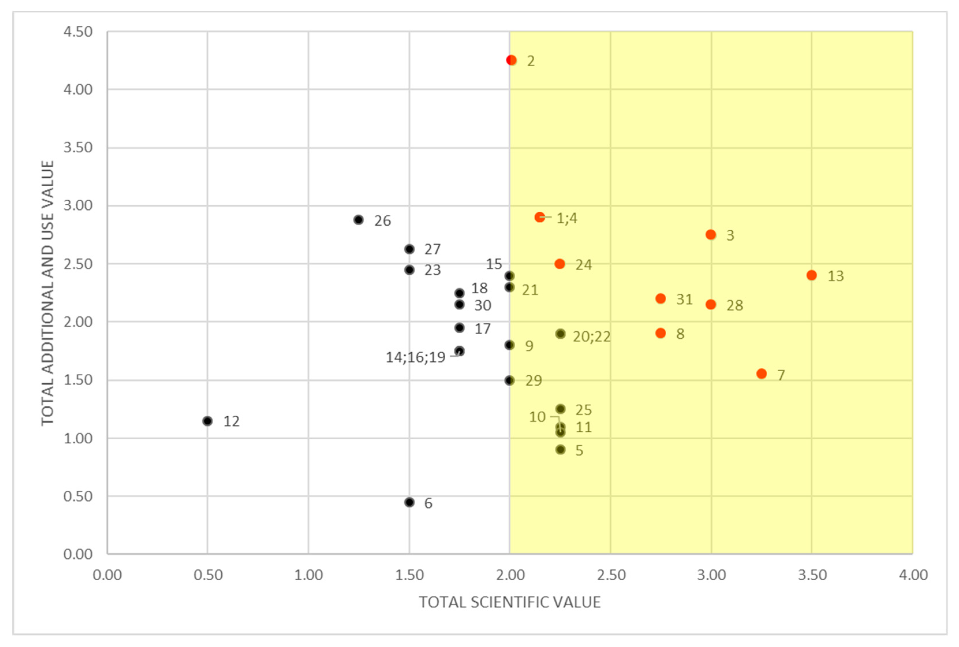
| Scientific value (SV) | Paleogeomorphological model | 0–1 | |
| Rareness | 0–1 | ||
| Representativeness | 0–1 | ||
| Integrity | 0–1 | ||
| Additional value (AV) | Ecological value | Ecological role support | 0–1 |
| Aesthetical value | Panoramic quality | 0–0.25 | |
| Color diversity | 0–0.25 | ||
| Vertical development | 0–0.25 | ||
| Naturalness | 0–0.25 | ||
| Cultural value | Religious importance | 0–0.33 | |
| Historical importance | 0–0.33 | ||
| Artistic importance | 0–0.33 | ||
| Use value(UV) | Accessibility | 0–0.75 | |
| Visibility | 0–0.75 | ||
| Services | 0–0.75 | ||
| Importance for education | 0–0.75 |
| ID | Feature | Location | Geosite Values | ||||
|---|---|---|---|---|---|---|---|
| SV | AV | UV | AV+UV | SV+AV+UV | |||
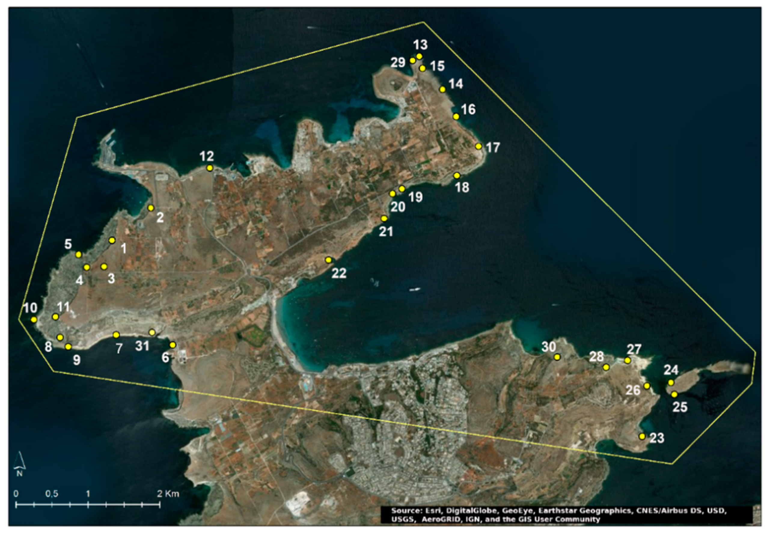
| 1 | Area affected by rock spreading | Ta’ Qassisu | 2.15 | 1.15 | 1.75 | 2.90 | 5.05 |
| 2 | Rock topple | Il-Bajja taċ-Ċirkewwa | 2.00 | 1.25 | 3.00 | 4.25 | 6.25 |
| 3 | Sinkhole | Ċirkewwa | 3.00 | 1.10 | 1.65 | 2.75 | 5.75 |
| 4 | Area affected by rock spreading | Rdum il-Qawwi | 2.15 | 1.40 | 1.50 | 2.90 | 5.05 |
| 5 | Rock window | Ta’ Qassisu | 2.25 | 0.65 | 0.25 | 0.90 | 3.15 |
| 6 | Marine cave | Ġebel Imbark | 1.50 | 0.30 | 0.15 | 0.45 | 1.95 |
| 7 | Lower Globigerina Limestone terrace | Rdum il-Qammieħ | 3.25 | 1.15 | 0.40 | 1.55 | 4.80 |
| 8 | Badland topography in Blue Clay slopes | Rdum il-Qammieħ | 2.75 | 1.00 | 0.90 | 1.90 | 4.65 |
| 9 | Dissolution structure (Globigerina pavement) | Rdum il-Qammieħ | 2.00 | 1.30 | 0.50 | 1.80 | 3.80 |
| 10 | Shore platform | Ras il-Qammieħ | 2.25 | 1.10 | 0.00 | 1.10 | 3.35 |
| 11 | Badland topography in Blue Clay slopes | Ras il-Qammieħ | 2.25 | 0.80 | 0.25 | 1.05 | 3.30 |
| 12 | Cart ruts | Il-Palazz tal-Marfa | 0.50 | 0.25 | 0.90 | 1.15 | 1.65 |
| 13 | Sinkhole | Il-Ponta tal-Aħrax | 3.50 | 1.00 | 1.50 | 2.40 | 6.00 |
| 14 | Marine Cave | Rdum l-Aħmar | 1.75 | 0.60 | 1.15 | 1.75 | 3.50 |
| 15 | Karst landform (limestone pavement) | Aħrax Point | 2.00 | 1.15 | 1.25 | 2.40 | 4.40 |
| 16 | Rock topple | Rdum l-Aħmar | 1.75 | 0.25 | 1.50 | 1.75 | 3.50 |
| 17 | Rock topple | Rdum tal-Madonna | 1.75 | 0.45 | 1.50 | 1.95 | 3.70 |
| 18 | Area affected by rock spreading | Il-Marbat | 1.75 | 0.75 | 1.50 | 2.25 | 4.00 |
| 19 | Rock topple | Rdum il-Ħmar | 1.75 | 0.50 | 1.25 | 1.75 | 3.50 |
| 20 | Badland topography in Blue Clay slopes | Rdum il-Ħmar | 2.25 | 0.75 | 1.15 | 1.90 | 4.15 |
| 21 | Area affected by rock spreading | Il-Parsott | 2.00 | 0.80 | 1.50 | 2.30 | 4.30 |
| 22 | Sinkhole | Ta’ L-Imgħarrqa | 2.25 | 0.65 | 1.25 | 1.90 | 4.15 |
| 23 | Area affected by rock spreading | Rdum il-Bies | 1.50 | 0.95 | 1.50 | 2.45 | 3.95 |
| 24 | Fault | Gżejjer ta’ San Pawl | 2.25 | 1.00 | 1.50 | 2.50 | 4.65 |
| 25 | Marine cave | Gżejjer ta’ San Pawl | 2.25 | 0.25 | 1.00 | 1.25 | 3.50 |
| 26 | Salinas | Blata l-Bajda | 1.25 | 0.88 | 2.00 | 2.88 | 4.13 |
| 27 | Salinas | Blata l-Bajda | 1.50 | 0.88 | 1.75 | 2.63 | 4.13 |
| 28 | Badland topography in Blue Clay slopes | Tal-Blata | 3.00 | 0.90 | 1.25 | 2.15 | 5.15 |
| 29 | Tsunami deposit | Il-Ponta tal-Aħrax | 2.00 | 0.25 | 1.25 | 1.50 | 3.50 |
| 30 | Area affected by rock spreading | Għajn Ħadid | 1.75 | 1.15 | 1.00 | 2.15 | 3.90 |
| 31 | Fault | Il-Qammieħ | 2.75 | 2.20 | 1.25 | 2.20 | 6.20 |
© 2019 by the authors. Licensee MDPI, Basel, Switzerland. This article is an open access article distributed under the terms and conditions of the Creative Commons Attribution (CC BY) license (http://creativecommons.org/licenses/by/4.0/).
Share and Cite
Selmi, L.; Coratza, P.; Gauci, R.; Soldati, M. Geoheritage as a Tool for Environmental Management: A Case Study in Northern Malta (Central Mediterranean Sea). Resources 2019, 8, 168. https://doi.org/10.3390/resources8040168
Selmi L, Coratza P, Gauci R, Soldati M. Geoheritage as a Tool for Environmental Management: A Case Study in Northern Malta (Central Mediterranean Sea). Resources. 2019; 8(4):168. https://doi.org/10.3390/resources8040168
Chicago/Turabian StyleSelmi, Lidia, Paola Coratza, Ritienne Gauci, and Mauro Soldati. 2019. "Geoheritage as a Tool for Environmental Management: A Case Study in Northern Malta (Central Mediterranean Sea)" Resources 8, no. 4: 168. https://doi.org/10.3390/resources8040168
APA StyleSelmi, L., Coratza, P., Gauci, R., & Soldati, M. (2019). Geoheritage as a Tool for Environmental Management: A Case Study in Northern Malta (Central Mediterranean Sea). Resources, 8(4), 168. https://doi.org/10.3390/resources8040168


