
Geosystem Services of Erratic Boulders in Selected Regions of Central Poland


Abstract
1. Introduction
2. A Review of the Existing Literature on the Topic
3. Objectives and Research Methods
3.1. Methods of Erratic Boulder Research
3.2. Methods of Lichenological Research
4. Research Area
5. Research Findings
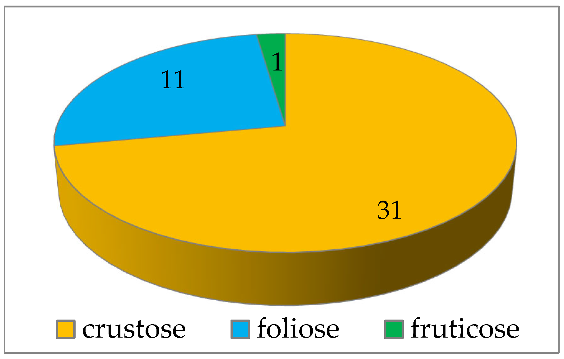
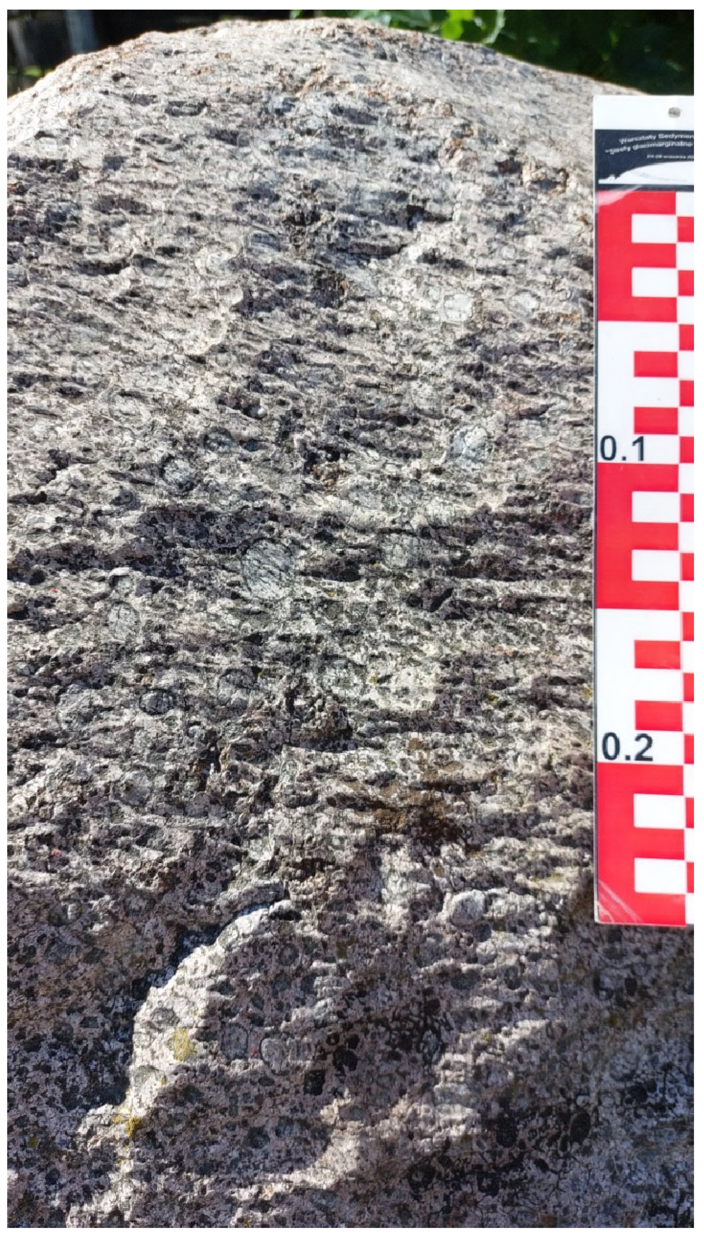
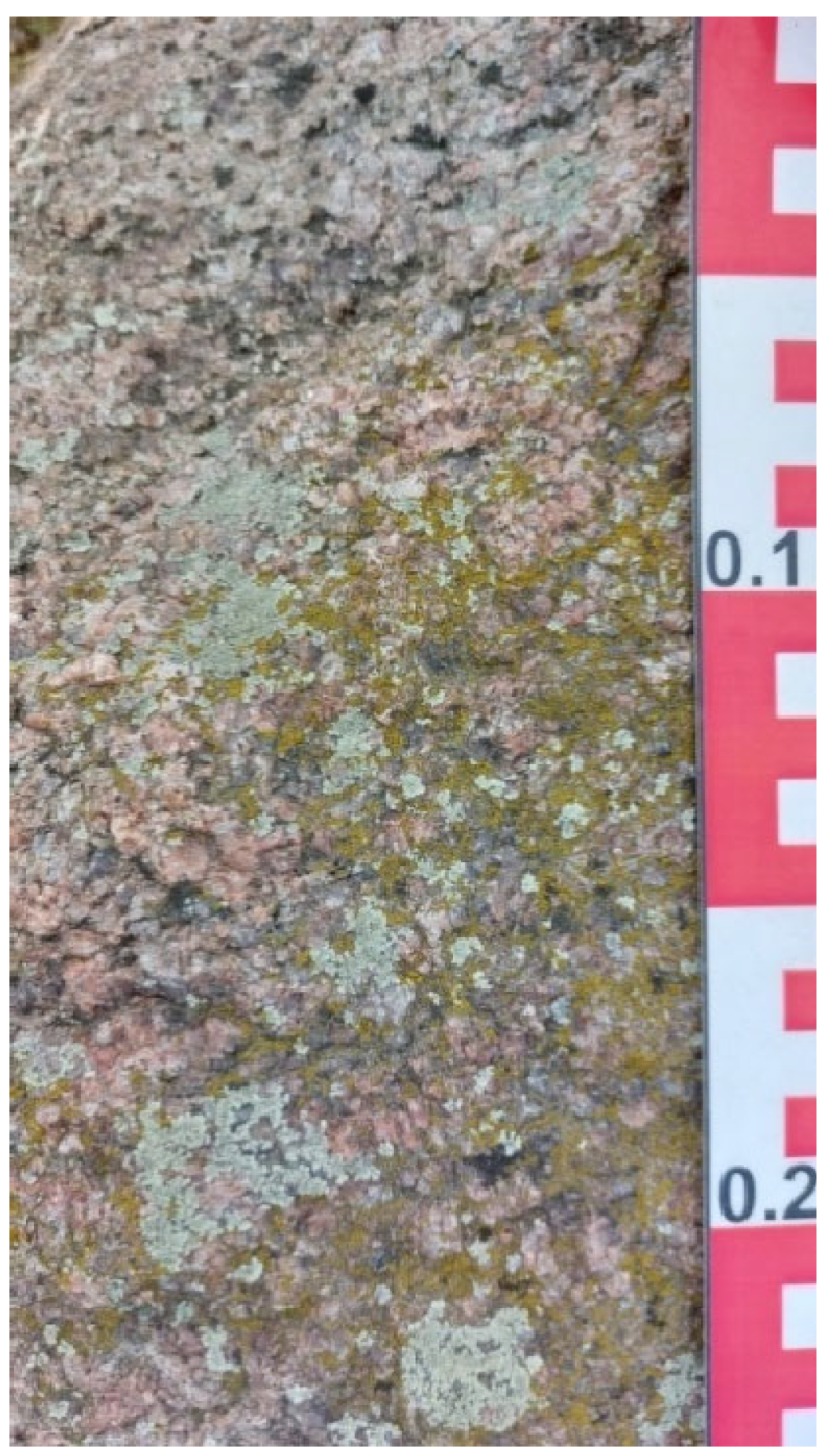
5.1. General Results of Lichenological Studies
5.2. Review of Erratic Boulders Colonised by Epilithic Biota Providing Geosystem Services to the Public
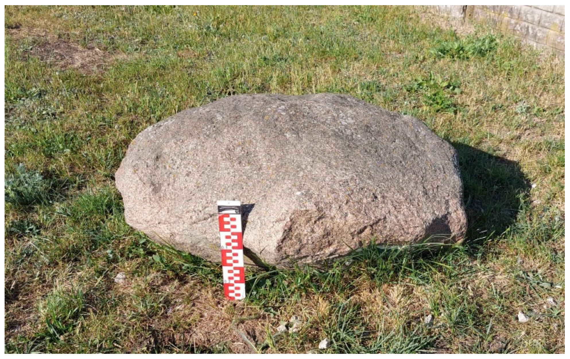
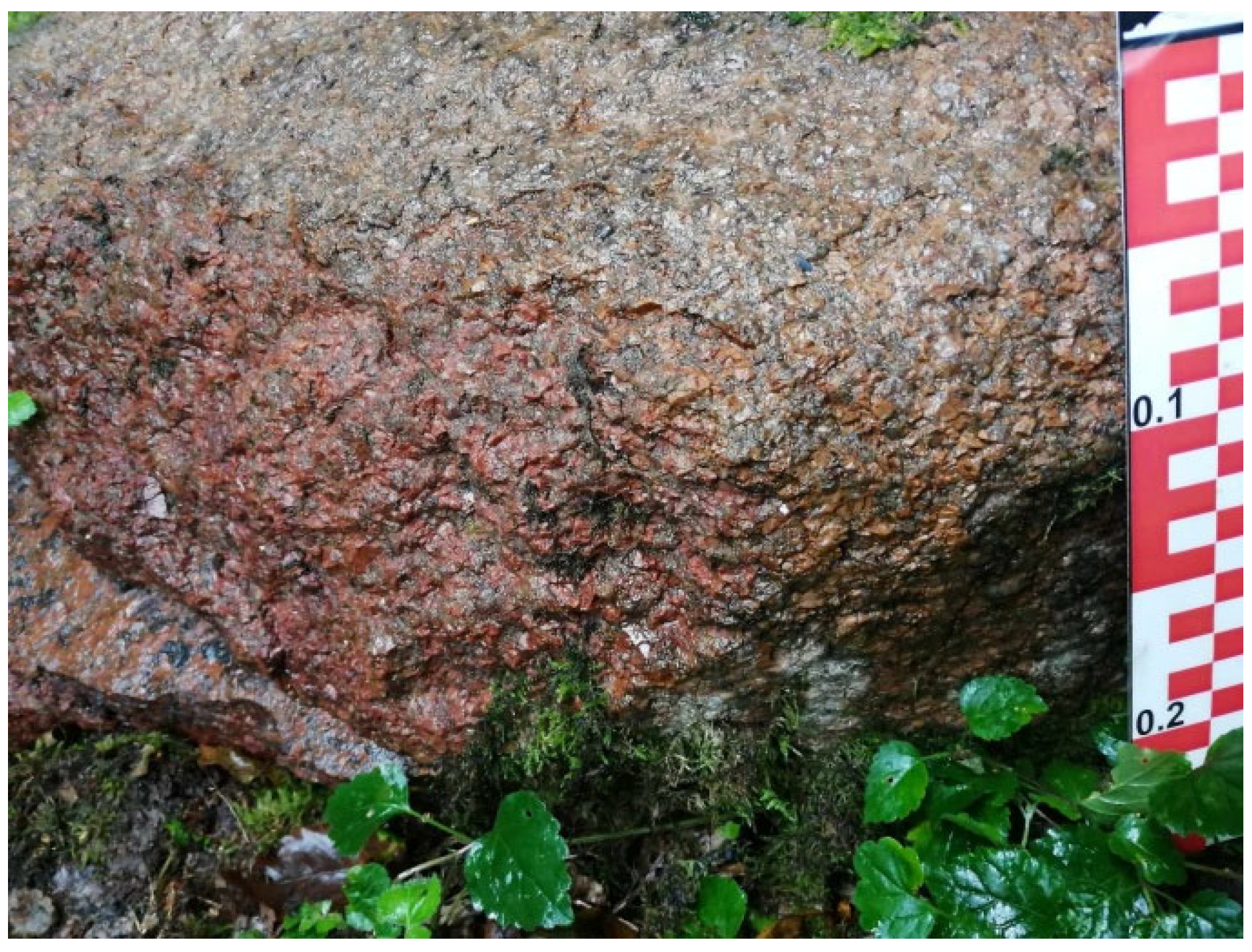
5.2.1. Erratic Boulders of the Radom Plain Area
5.2.2. Epilithic Biota of Erratic Boulders of the Radom Plain Area
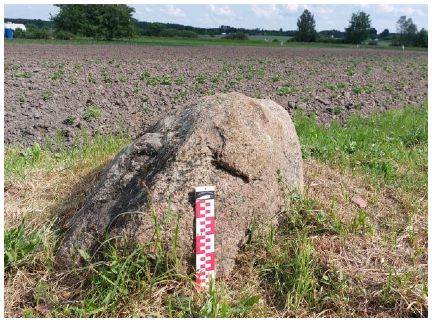
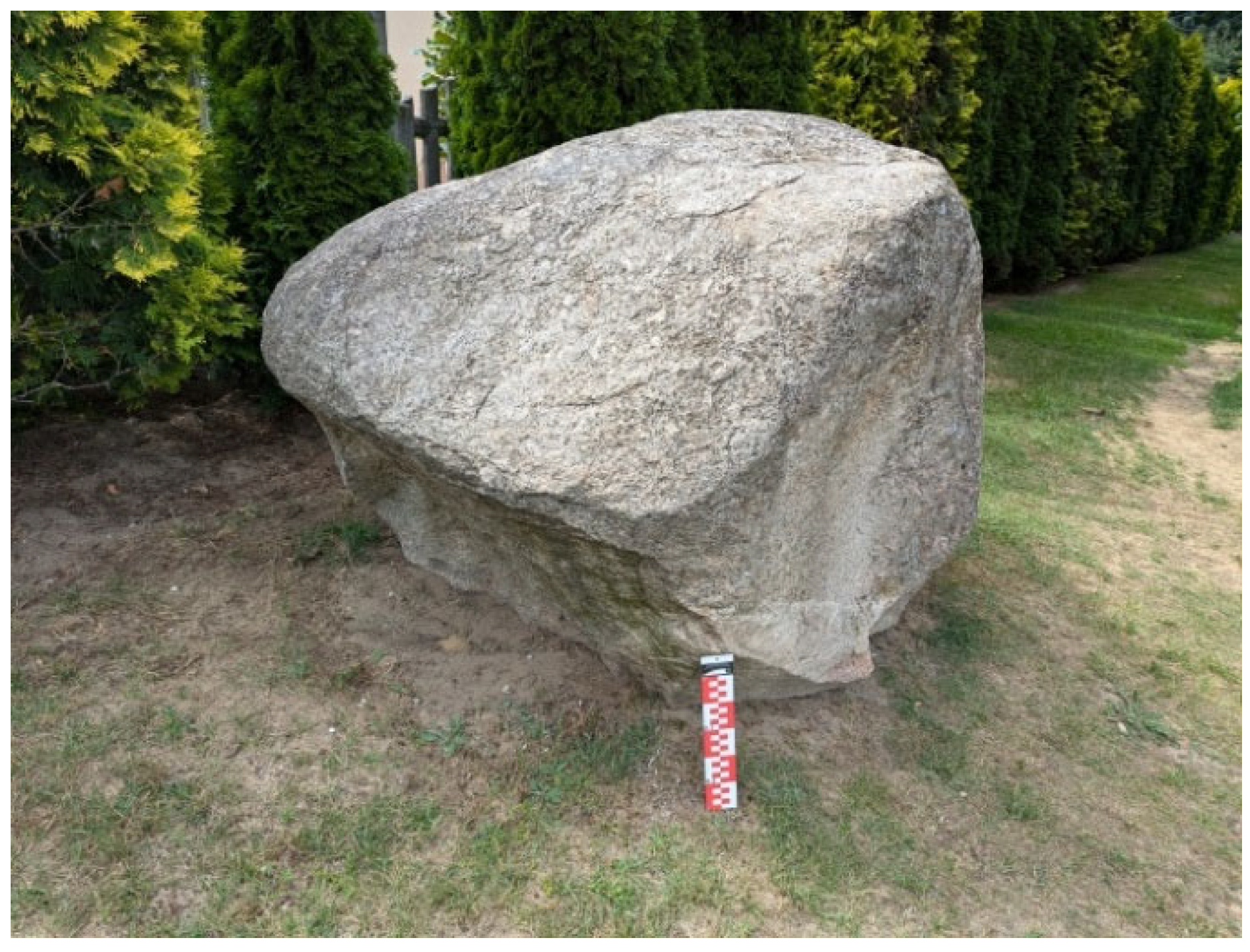
5.2.3. Erratic Boulders in the Połaniec Basin Area
5.2.4. Epilithic Biota of Erratic Boulders of the Połaniec Basin Area
6. Discussion
- Scientific: These boulders represent a specific petrological type that serves as a hallmark of the geological processes that led to their formation. Furthermore, they stand as a testament to various geomorphological processes that transpired during the early stages in Scandinavia, followed by their transportation to the glacial deposition areas in the Małopolska Upland, and finally during the retreat of the San II Glaciation (MIS 12) [115] and the Odranian Glaciation (MIS 6) [115] of the Middle Polish Glaciations Complex in the study area. Among the studied objects are indicator erratics that point to the area of their glacial alimentation.
- Geoethical/cultural: These boulders cultivate a sense of place among the local community, which selected five erratic boulders from the Radom Plain (29, 66c, 84a, 66c, 66e) and the Połaniec Basin (66c, 66e, 75b, 85b, 92b) to erect a monument with an informational plaque. This initiative serves as a wayfinding tool and, in a sentimental role, commemorates the times of land development on private properties. Geoethics should be integral to everyone who values nature, as a sense of place is a predictor of pro-environmental behaviours.
- Pro-environmental/educational: This study found that several boulders, among the 25 studied, triggered sensitivity to non-living nature among the local residents, leading to a commitment to preserve and care for these objects. Such behaviours and beliefs, once internalised, will guide informed recipients towards decisions about legal protection for the geological object. At the time of writing this article, one of the boulders (No. 10 in Wiśniowa, near Staszów) is undergoing a process of legal protection according to the decision of its owners.
- Aesthetic: The erratic boulder from Wiśniowa mentioned above has been exposed by its owners in a prominent place on their property. Its strategic placement within a flowerbed has also been noted, contributing to the owners’ overall sense of aesthetic satisfaction. A similar function is served by boulder No. 90c in Chomętów-Socha, which adorns the village’s relaxation area.
- 5.
- Educational: This would necessitate the installation of an informative plaque with comprehensible text for all visitors to the erratic boulder. The dissemination of knowledge could be facilitated by a geointerpreter, such as a teacher, guide, or local nature enthusiast. Each of these individuals could highlight details on the boulder that demonstrate its petrological type, as well as the recorded signs of processes from different stages of the boulder’s “life.” For instance, a geography teacher could facilitate a discussion on the various types of rock and glacial activities, an art teacher could lead an outdoor drawing session, a mathematics teacher could offer a lesson on measurements and calculations related to the volume and weight of the rock block, a chemistry teacher could highlight minerals and teach their chemical formulas, and a Polish language teacher could assign writing tasks, such as an essay. The educational function of erratic boulders in proximity to a school has the greatest potential for success: the collection of geo-objects would provide a safe and eagerly awaited outdoor lesson for students.
- 6.
- Geoethical: The promotion of awareness among the local community of their distinctive position on Earth has the capacity to counteract atomistic behaviours and re-establish the environmental equilibrium necessary to guarantee the sustained delivery of geosystem services. This would pave the way for a more sustainable and resilient future.
- 7.
- Cultural: It is noteworthy that only one of the 25 erratic boulders under scrutiny is associated with a local legend, namely “The Wooden Stone” (No. 33 in Kowala, the Radom Plain). The largest boulders (Nos. 75b in the Radom Plain and 13 in the Połaniec Basin) could be assigned unique names through a local competition involving nearby residents. The erection of an obelisk at significant historical sites within the region, as exemplified by boulder No. 75b in Bardzice, or utilising the boulder as a pedestal for a sculpture symbolising a figure of regional importance, would further enhance the cultural significance of these boulders.
- 8.
- Pro-environmental/educational: Boulder No. 90c (currently located in Chomętów-Socha) and other currently unused boulders (No. 66a, 70, 89a, 90a, 96b, 96c in the Radom Plain and No. 7 in Pliskowola and No. 14 from Kotuszów in the Połaniec Basin) could be relocated to frequently visited locations. Accompanying these boulders should be an informational plaque that aims to raise awareness among passersby of the role and significance of the abiotic component of the surrounding nature in maintaining ecological balance, and consequently human well-being.
- 9.
- Geoenvironmental: All erratic boulders provide geosystem services (i.e., goods and services performed by nature) for the benefit of both humans and nature. However, the authors did not find any platform where these important functions, essential to human economic activities, were publicly disseminated. In the event that the local community is aware of these benefits, there is a strong likelihood that they would utilise erratic boulders in a manner that would enhance the well-being of the residents to a considerable extent. In order to benefit from these services, ensuring a better quality of life for the future, the population would engage with geoheritage in a sustainable way, maintaining ecological balance in their immediate surroundings.
- 10.
- Geoconservation: It is posited that if residents of both study areas adhered to geoethics and calotropy (surrounding themselves with beauty and goodness), legal protection would have been ensured for some of the studied erratic boulders in accordance with the [116]. Only two of the erratic boulders in the study areas are currently legally protected as inanimate nature monuments, and none are listed on [111].
- 11.
- Aesthetic: The residents of the Radom Plain and the Połaniec Basin could experience an enhancement in their quality of life if they recognised the potential of erratic boulders to improve the aesthetic quality of their properties or the nearby squares. For instance, utilising funds from a municipal budget, they could propose the establishment of pocket gardens in lieu of neglected, undeveloped plots situated within their villages or towns. This approach would create a mutually beneficial scenario, wherein the neglected areas would be revitalised aesthetically, while the exposed erratic boulders would serve a geoenvironmental function. This initiative would not only enhance the local environment but also garner positive evaluations from residents and visitors alike, thereby fostering a sense of community pride and engagement.
7. Conclusions
Supplementary Materials
Author Contributions
Funding
Data Availability Statement
Acknowledgments
Conflicts of Interest
References
- Gray, M. Geodiversity: Valuing and Conserving Abiotic Nature, 2nd ed.; Wiley Blackwell: Chichester, UK, 2013. [Google Scholar]
- Gray, M. Geodiversity: The Backbone of Geoheritage and Geoconservation. In Geoheritage: Assessment, Protection, and Management; Reynard, E., Brilha, J., Eds.; Elsevier: Amsterdam, The Netherlands, 2018; pp. 13–25. [Google Scholar]
- Ng, Y. Special issue on geodiversity. Editorial. Int. J. Geoheritage Parks 2022, 10, A1–A3. [Google Scholar] [CrossRef]
- Górska-Zabielska, M.; Błaszczyk, N.; Nowak, I. The geoheritage potential of the south-east Pałuki (western Poland) to promote geotourism. Geoj. Tour. Geosites 2024, 52, 294–312. [Google Scholar] [CrossRef]
- Szarzyńska, A.; Ziółkowski, P. Skandynawskie Dary: Głazy Narzutowe Warmii i Mazur; Wydawnictwo Mantis, Andrzej Stefan Jadwiszczak: Olsztyn, Poland, 2012. [Google Scholar]
- Szarzyńska, A. Wzgórza Dylewskie terenową wystawą muzealną głazów narzutowych. Nat. Przyr. Warm. Mazur 2015, 4, 26–37. [Google Scholar]
- Woźniak, P.; Tylmann, K.; Kobiela, A. Głazy narzutowe Trójmiejskiego Parku Krajobrazowego—Potencjał badawczy i geoturystyczny. Przegląd Geol. 2015, 63, 256–262. [Google Scholar]
- Górska-Zabielska, M. The Rock Garden of the Institute of Geography and Environmental Sciences, Jan Kochanowski University—A New Geo-site in Kielce, Central Poland. Geosci. 2021, 11, 113. [Google Scholar] [CrossRef]
- Górska-Zabielska, M. A New Geosite as a Contribution to the Sustainable Development of Urban Geotourism in a Tourist Peripheral Region—Central Poland. Resources 2023, 12, 71. [Google Scholar] [CrossRef]
- Górska-Zabielska, M. Scandinavian Erratics in the Cultural Heritage Sites of Western Poland. Land 2024, 13, 1282. [Google Scholar] [CrossRef]
- Górska-Zabielska, M. Newly Discovered Massive Glacial Boulder in Northwestern Poland: Implications and Prospects for Sustainable Regional Growth. Geoj. Tour. Geosites 2024, 55, 1243–1253. [Google Scholar] [CrossRef]
- Solon, J.; Roo-Zielińska, E.; Affek, A.; Kowalska, A.; Kruczkowska, B.; Wolski, J.; Degórski, M.; Grabińska, B.; Kołaczkowska, E.; Regulska, E.; et al. Świadczenia Ekosystemowe w Krajobrazie Młodoglacjalnym. Ocena Potencjału i Wykorzystania; Instytut Geografii i Przestrzennego Zagospodarowania Polska Akademia Nauk, Wydawnictwo Akademickie SEDNO: Warsaw, Poland, 2017. [Google Scholar]
- Gray, M.; Fox, N.; Gordon, J.; Brilha, J.; Charkraborty, A.; Garcia, M.d.G.; Hjort, J.; Kubalíková, L.; Seijmonsbergen, A.; Urban, J. Boundary of ecosystem services: A response to Chen et al. (2023). J. Environ. Manag. 2024, 351, 119666. [Google Scholar] [CrossRef]
- Piotrowski, K. Dobry pomysł na biznes. Kamieniarstwo “głazowe”. Nowy Kamieniarz 2008, 34, 58–62. [Google Scholar]
- Chrząszczewski, W. Stoneman spod Konina. Nowy Kamieniarz 2009, 43, 40–44. [Google Scholar]
- Richling, A.; Solon, J. Ekologia Krajobrazu; Wydawnictwo Powszechne Wydawnictwo Naukowe: Warsaw, Poland, 2011. [Google Scholar]
- Wolniewicz, P. Bringing the History of the Earth to the Public by Using Storytelling and Fossils from Decorative Stones of the City of Poznań, Poland. Geoheritage 2019, 11, 1827–1837. [Google Scholar] [CrossRef]
- Kubalíková, L.; Bajer, A.; Balková, M. Brief Notes on Geodiversity and Geoheritage Perception by the Lay Public. Geosciences 2021, 11, 54. [Google Scholar] [CrossRef]
- Garofano, M. Geowatching, a Term for the Popularisation of a Geological Heritage. Geoheritage 2015, 7, 25–32. [Google Scholar] [CrossRef]
- Tetik, N. The Importance of Interpretatıon Role of Tour Guıdes in Geotourısm: Can We Called Them as Geotour Guıdes? Int. J. Educ. Soc. Sci. 2016, 3, 41–53. Available online: https://www.academia.edu/34545497/The_Importance_of_Interpretat%C4%B1on_Role_of_Tour_Gu%C4%B1des_in_Geotour%C4%B1sm_Can_We_Called_Them_as_Geotour_Gu%C4%B1des (accessed on 15 March 2025).
- Tormey, D. New approaches to communication and education through geoheritage. Int. J. Geoheritage Parks 2019, 7, 192–198. [Google Scholar] [CrossRef]
- Górska-Zabielska, M. New Geoeducational Facilities in Central Mazovia (Poland) Disseminate Knowledge about Local Geoheritage. Sustainability 2023, 15, 16115. [Google Scholar] [CrossRef]
- Zgłobicki, W.; Nowak, I.; Baran-Zgłobicka, B.; Głuszek, A. The Use of Geosites in Education—A Case Study in Central Poland. Resources 2024, 13, 15. [Google Scholar] [CrossRef]
- Lundquist, T. The Precambrian of Sweden. Sver. Geol. Undersoekning 1979, C 768, 128–191. [Google Scholar]
- Ager, D.V. Fenno-Scandian Shield. In The Geology of Europe; Ager, D.V., Ed.; McGraw Hill Book Co.: London, UK, 1980. [Google Scholar]
- Gorbatschev, R. The Precambrian development of southern Sweden. Geol. Foereningens Stockh. Foerhandlingar 1980, 102, 129–136. [Google Scholar] [CrossRef]
- Gorbatschev, R. Precambrian basement of the Scandinavian Caledonides. In The Caledonide Orogeny—Scandinavia and Related Areas; Gee, D.G., Sturt, B.A., Eds.; Wiley & Sons: Chichester, UK, 1985; pp. 197–212. [Google Scholar]
- Gaál, G.; Gorbatschev, R. An outline of the Precambrian evolution of the Baltic Shield. Precambrian Res. 1987, 35, 15–52. [Google Scholar] [CrossRef]
- Andréasson, P.G.; Rodhe, A. Geology of the Protogine Zone south of the Lake Vaettern, southern Sweden: A reinterpretation. Geol. Foereningens Forh. 1990, 112, 107–125. [Google Scholar] [CrossRef]
- Fredén, C. Geology—National Atlas of Sweden; Geol. Survey of Sweden: Stockholm, Sweden, 1994. [Google Scholar]
- Lundquist, T.; Bygghammar, B. The Bedrock. The Swedish Precambrian. In National Atlas of Sweden: Geology; Freden, C., Ed.; National Committee of Geography Under Auspices of the Royal Swedish Academy of Science; Almqvist & Wiksell International: Stockholm, Sweden, 1994; pp. 14–21. [Google Scholar]
- Tuuling, I.; Flodén, T. The structure and relief of the bedrock sequence in the Gotland-Hiiumaa area, northern Baltic Sea. Geol. Föreningens Stockh. Förhandlingar 2001, 123, 35–49. [Google Scholar] [CrossRef]
- Cocks, L.R.M.; Torsvik, T.H. Baltica from the late Precambrian to mid-Palaeozoic times: The gain and loss of a terrane’s identity. Earth-Sci. Rev. 2005, 72, 39–66. Available online: https://earthdynamics.org/torsvik/torsvik-papers/2005/2005-Cocks-Torsvik-ESR.pdf (accessed on 15 March 2025). [CrossRef]
- Bogdanova, S.; Bingen, B.; Gorbatschev, R.; Kheraskova, T.N.; Kozlov, V.I.; Puchkov, V.N.; Volozh, Y.A. The East Europaen Craton (Baltica) before and during the assembly of Rodinia. Precambrian Res. 2008, 160, 23–45. [Google Scholar] [CrossRef]
- Hölltä, P.; Balagansky, V.; Garde, A.A.; Mertanen, S.; Peltonen, P.; Slabunov, A.; Sorjonen-Ward, P.; Whitehouse, M. Archean of Greenland and Fennoscandia. Episodes 2008, 31, 13–19. [Google Scholar] [CrossRef]
- Wohlfarth, G.; Hammerle, A.; Haslwanter, A.; Bahn, M.; Tappeiner, U.; Cernusca, A. Disentangling leaf area and environmental effects on the response of the net ecosystem CO2 exchange to diffuse radiation. Geophys. Res. Lett. 2008, 35, L16805. [Google Scholar] [CrossRef]
- Schulz, W. Zur Bedeutung der Korngröße bei Geschiebezählungen. Geschiebesammler 1996, 29, 91–102. [Google Scholar]
- Schulz, W. Sedimentäre Findlinge im norddeutschen Vereisungsgebiet. Arch. Geschiebekunde 1999, 2, 523–560. [Google Scholar]
- Górska-Zabielska, M. Najcenniejsze głazy narzutowe w Wielkopolsce i ich potencjał geoturystyczny. Przegląd Geol. 2015, 63, 455–463. Available online: https://www.pgi.gov.pl/dokumenty-pig-pib-all/publikacje-2/przeglad-geologiczny/2015/sierpien-4/3197-najcenniejsze-glazy-narzutowe-w-wielkopolsce-i-ich-potencjal-geoturystyczny/file.html (accessed on 15 March 2025).
- Górska-Zabielska, M. The most valuable erratic boulders in the Wielkopolska region of western Poland and their potential to promote geotourism. Geoj. Tour. Geosites 2020, 29, 694–714. [Google Scholar] [CrossRef]
- Serrano, E.; Ruiz-Flano, P. Geodiversity. A theoretical and applied concept. Geogr. Helv. 2007, 62, 140–147. [Google Scholar] [CrossRef]
- Gray, M. Geodiversity: Valuing and Conserving Abiotic Nature; John Wiley and Sons: Chichester, UK, 2004. [Google Scholar]
- Gray, M. Geodiversity and Geoconservation: What, Why, and How? Geodiversity Geoconservation 2005, 22, 4–11. [Google Scholar]
- Brilha, J.; Grayb, M.; Pereira, D.I.; Pereira, P. Geodiversity: An integrative review as a contribution to the sustainable management of the whole of nature. Environ. Sci. Policy 2018, 86, 19–28. [Google Scholar] [CrossRef]
- Coratza, P.; Reynard, E.; Zwoliński, Z. Geodiversity and Geoheritage: Crossing Disciplines and Approaches. Geoheritage 2018, 10, 525–526. [Google Scholar] [CrossRef]
- Zwoliński, Z.; Najwer, A.; Giardino, M. Methods for Assessing Geodiversity. In Geoheritage: Assessment, Protection, and Management; Reynard, E., Brilha, J., Eds.; Elsevier: Amsterdam, The Netherlands, 2018; pp. 27–52. [Google Scholar]
- Wolniewicz, P. Beyond Geodiversity Sites: Exploring the Educational Potential of Widespread Geological Features (Rocks, Minerals and Fossils). Geoheritage 2021, 13, 34. [Google Scholar] [CrossRef]
- Reynard, E. Geosite. In Encyclopedia of Geomorphology; Goudie, A., Ed.; Routledge: London, UK, 2004; Volume 1, p. 440. [Google Scholar]
- Migoń, P. Geomorfologia; Wydawnictwo Powszechne Wydawnictwo Naukowe: Warsaw, Poland, 2012. [Google Scholar]
- Migoń, P.; Różycka, M. When Individual Geosites Matter Less—Challenges to Communicate Landscape Evolution of a Complex Morphostructure (Orlické–Bystrzyckie Mountains Block, Czechia/Poland, Central Europe). Geosciences 2021, 11, 100. [Google Scholar] [CrossRef]
- Rinterknecht, V.; Marks, L.; Piotrowski, J.A.; Raisbeck, G.M.; Yiou, F.; Brook, E.J.; Clark, P.U. Cosmogenic 10Be ages on the Pomeranian Moraine, Poland. Boreas 2005, 34, 186–191. [Google Scholar] [CrossRef]
- Rinterknecht, V.; Braucher, R.; Böse, M.; Bourlês, D.; Mercier, J.-L. Late Quaternary ice sheet extents in northeastern Germany inferred from surface exposure dating. Quatern. Sci. Rev. 2012, 44, 89–95. [Google Scholar] [CrossRef]
- Ivy-Ochs, S.; Kober, F. Surface exposure dating with cosmogenic nuclides. Eiszeitalter und Gegenwart. Quatern. Sci. J. 2008, 57, 179–209. [Google Scholar]
- Tylmann, K.; Rinterknecht, V.R.; Woźniak, P.P.; Bourlês, D.; Schimmelpfennig, I.; Guillou, V.; Aster Team. The Local Last Glacial Maximum of the southern Scandinavian Ice Sheet front: Cosmogenic nuclide dating of erratics in northern Poland. Quatern. Sci. Rev. 2019, 219, 36–46. [Google Scholar] [CrossRef]
- Tylmann, K.; Woźniak, P.P.; Rinterknecht, V. Analiza przydatności eratyków Pomorza w badaniach chronologii recesji ostatniego lądolodu skandynawskiego metodą izotopów kosmogenicznych. Acta Geogr. Lodz. 2017, 106, 181–194. [Google Scholar]
- Kirillova, K.S.; Fu, X.; Lehto, X.; Liping Cai, L. What makes a destination beautiful? Dimensions of tourist aesthetic judgment. Tour. Manag. 2014, 42, 282–293. [Google Scholar] [CrossRef]
- Kirillova, K.; Lehto, X. Destination Aesthetics and Aesthetic Distance in Tourism Experience. J. Travel Tour. Mark. 2015, 32, 1051–1068. [Google Scholar] [CrossRef]
- Gołaszewska, M. Estetyka Współczesności; Wydawnictwo Uniwersytetu Jagiellońskiego: Kraków, Poland, 2001. [Google Scholar]
- Kieliszek, Z.; Kulczyk, S. Przewodnicy sudeccy jako moderatorzy dostawy kulturowych usług ekosystemowych w Karkonoskim Parku Narodowym. Pr. Stud. Geogr. 2024, 69, 111–123. [Google Scholar] [CrossRef]
- Mączka, K.; Matczak, P. Is The Ecosystem Services Concept Useful in Polish Policy Making? Qualitative Analysis of Experts Perception. Econ. Environ. 2014, 4, 68–75. [Google Scholar]
- Mączka, K. Ecosystem Services in Environmental Discourse—Application of Ecosystem Services Concept in Poland. Ph.D. Thesis, Institute of Sociology Adam Mickiewicz University, Poznan, Poland, 2019. Available online: https://repozytorium.amu.edu.pl/server/api/core/bitstreams/9a7f3ba8-2ba4-41ce-85e9-e3577cfd0b1e/content (accessed on 10 March 2025).
- Górska-Zabielska, M. Ścieżka przyrodnicza—Atrakcją geoturystyczną i kluczem do zrównoważonego rozwoju miasta. Pr. Stud. Geogr. 2024, 69, 55–57. [Google Scholar] [CrossRef]
- Meyer, K.-D. Der Findlingsgärten in Niedersachsen. Arch. Geschiebekd. 2006, 5, 323–338. [Google Scholar]
- Keiter, M. Die „Großen Sieben” und der neue Findlingsgarten in Bielefeld-Botschafter vom saalezeitlichen Eisrand. Geschiebekd. Aktuell 2017, 33, 119–129. [Google Scholar]
- Peppoloni, S.; Di Capua, G. Geoethics and geological culture: Awareness, responsibility and challenges. Ann. Geophys. (Ann. Geofis.) 2012, 3, 335–341. [Google Scholar] [CrossRef]
- Urban, J.; Migoń, P.; Radwanek-Bąk, B. Dziedzictwo geologiczne. Przegląd Geol. 2021, 69, 16–20. [Google Scholar] [CrossRef]
- Mosios, S.; Georgousis, E.; Drinia, H. The Status of Geoethical Thinking in the Educational System of Greece: An Overview. Geosciences 2023, 13, 37. [Google Scholar] [CrossRef]
- Koupatsiaris, A.A.; Drinia, H. Expanding Geoethics: Interrelations with Geoenvironmental Education and Sense of Place. Sustainability 2024, 16, 1819. [Google Scholar] [CrossRef]
- Hose, T.A. Geotourism and interpretation. In Geotourism; Dowling, R., Newsome, D., Eds.; Elsevier Butterworth-Heinemann: Oxford, UK, 2005; pp. 221–241. [Google Scholar]
- Hose, T.A. 3G’s for modern geotourism. Geoheritage 2012, 4, 7–24. [Google Scholar] [CrossRef]
- Dowling, R.K.; Newsome, D. Geotourism’s issues and challenges. In Geotourism; Dowling, R., Newsome, D., Eds.; Elsevier Butterworth-Heinemann: Oxford, UK, 2005; pp. 242–254. [Google Scholar]
- Górska-Zabielska, M.; Dobracki, R. Petrographic Garden in Moryń—A new geotouristic attraction in western Poland. Landf. Anal. 2015, 29, 73–80. [Google Scholar] [CrossRef]
- Górska-Zabielska, M.; Zabielski, R. Geotourism Development in an Urban Area based on the Local Geological Heritage (Pruszków, Central Mazovia, Poland). In Urban Geomorphology. Landforms and Processes in Cities; Thornbush, M.J., Allen, D., Eds.; Elsevier: Amsterdam, The Netherlands, 2018; pp. 37–54. [Google Scholar] [CrossRef]
- Górska-Zabielska, M.; Kusztal, P.; Witkowska, K. Wybrane głazy narzutowe północno-zachodniego obrzeżenia Gór Świętokrzyskich—Współczesne znaczenie i potencjał geoturystyczny (Wyżyna Przedborska i Kielecka). Przegląd Geol. 2019, 67, 767–774. [Google Scholar] [CrossRef]
- Czernicka-Chodkowska, D. Zabytkowe Głazy Narzutowe na Obszarze Polski. Część III, Polska Południowo-Wschodnia i Południowa; Wydawnictwa Geologiczne: Warsaw, Poland, 1980. [Google Scholar]
- Czernicka-Chodkowska, D. Zabytkowe Głazy Narzutowe na Obszarze Polski. Część IV, Polska Północna, Środkowa i Południowo-Zachodnia. Głazy Warszawy; Wydawnictwa Geologiczne: Warsaw, Poland, 1983. [Google Scholar]
- Barcicki, M. Objaśnienia do Szczegółowej Mapy Geologicznej Polski 1:50,000, Arkusz Wierzbica (743). Państwowy Instytut Geologiczny. Wydawnictwa Geologiczne: Warsaw, Poland, 1990. [Google Scholar]
- Czernicka-Chodkowska, D. Zabytkowe Głazy Narzutowe na Obszarze Polski. Katalog cz. I i II; Wydawnictwa Geologiczne: Warsaw, Poland, 1977. [Google Scholar]
- Urban, J. Geologia i rzeźba obszaru badań. In Waloryzacja Przyrodnicza Szanieckiego Parku Krajobrazowego; Zając, T., Ed.; Archiwum Instytutu Ochrony Przyrody, Polska Akademia Nauk: Kraków, Poland, 1997. [Google Scholar]
- Stoiński, A. Głazy Narzutowe w Okolicy Radoszyc. Master’s Thesis, Archiwum Instytutu Geografii i Nauk o Środowisku, Uniwersytet Jana Kochanowskiego, Kielce, Poland, 1997. [Google Scholar]
- Pernal, J. Pomniki Przyrody Woj. Świętokrzyskiego. Głazy Narzutowe. Część 1; Liga Ochrony Przyrody: Kielce, Poland, 2004. [Google Scholar]
- Pernal, J. Pomniki Przyrody Woj. Świętokrzyskiego. Głazy Narzutowe. Część 2; Liga Ochrony Przyrody: Kielce, Poland, 2005. [Google Scholar]
- Górska-Zabielska, M. Obszary macierzyste głazów narzutowych w kontekście rzeźby regionu świętokrzyskiego (Source areas of erratic boulders in a context of morphology of the Świętokrzyskie [Holy Cross] Mountains region). In VII Warsztaty Geomorfologii Strukturalnej. Rzeźba Strukturalna Gór Świętokrzyskich i Ponidzia—Stan Badań i Perspektywy Badawcze. Streszczenia Referatów i Posterów, Przewodnik Sesji Terenowych; Urban, J., Ed.; Instytut Ochrony Przyrody Polska Akademia Nauk: Kraków, Poland, 2019; pp. 18–19. [Google Scholar]
- Górska-Zabielska, M.; Witkowska, K.; Pisarska, M.; Musiał, R.; Jońca, B. The Selected Erratic Boulders in the Świętokrzyskie Province (Central Poland) and Their Potential to Promote Geotourism. Geoheritage 2020, 12, 30. [Google Scholar] [CrossRef]
- Górska-Zabielska, M.; Wieczorek, D.; Zabielski, R.; Stoiński, A. Głazy narzutowe z regionu Przedborza jako obiekty geodziedzictwa oraz ich znaczenie dla geologii czwartorzędu i geoturystyki. Przegląd Geol. 2022, 70, 34–49. [Google Scholar] [CrossRef]
- Walczowski, A. Objaśnienia do Szczegółowej Mapy Geologicznej Polski 1:50,000, Arkusz Staszów (M 34–55 A); Instytut Geologiczny, Wydawnictwa Geologiczne: Warszawa, Poland, 1968. [Google Scholar]
- Purvis, W. Lichens; Smithsonian Institute Press: Washington, DC, USA, 2000. [Google Scholar]
- Link, S.O.; Nash, T.H. An analysis of an arctic lichen community with respect to slope on siliceous rocks at Anaktuvuk Pass, Alaska. Bryologist 1984, 87, 162–166. [Google Scholar] [CrossRef]
- Hepenstrick, D.; Bergamini, A.; Webster, C.; Ginzler, C.; Holderegger, R. Factors determining bryophyte species richness and community composition on insular siliceous erratic boulders in calcareous landscapes. J. Veg. Sci. 2021, 32, e13094. [Google Scholar] [CrossRef]
- Rutherford, R.; Rebertus, A. A habitat analysis and influence of scale in lichen communities on granitic rock. Bryologist 2022, 125, 43–60. [Google Scholar] [CrossRef]
- Orwin, J. The effect of environment on assemblages of lichens growing on rock surfaces. N. Z. J. Bot. 1972, 10, 37–47. [Google Scholar] [CrossRef]
- Armstrong, R.A. The influence of climate on the dispersal of lichen soredia. Environ. Exp. Bot. 1991, 31, 239–245. [Google Scholar] [CrossRef]
- Bjellend, T.; Thorseth, I.H. Comparative studies of the lichen-rock interface of four lichens in Vingen, western Norway. Chem. Geol. 2002, 192, 81–98. [Google Scholar] [CrossRef]
- Fałtynowicz, W. Porosty głazów narzutowych parków krajobrazowych Trójmiejskiego i Kaszubskiego. Monogr. Bot. 1997, 81, 64. [Google Scholar]
- Górska-Zabielska, M. Głazy narzutowe Kielecczyzny i ich potencjał geoturystyczny. In Plejstocen Gór Świętokrzyskich. XXV Konferencja Stratygrafia Plejstocenu Polski, Huta Szklana k/Bielin, 3-7.09.2018; Ludwikowska-Kędzia, M., Wiatrak, M., Eds.; Instytut Geografii Uniwersytet Jana Kochanowskiego: Kielce, Poland, 2018; pp. 84–86. [Google Scholar]
- Górska-Zabielska, M. Głazy narzutowe z obszaru wycieczek terenowych 25SPP i jego otuliny. In Plejstocen Gór Świętokrzyskich. XXV Konferencja Stratygrafia Plejstocenu Polski, Huta Szklana k/Bielin, 3-7.09.2018; Ludwikowska-Kędzia, M., Wiatrak, M., Eds.; Instytut Geografii Uniwersytet Jana Kochanowskiego: Kielce, Poland, 2018; pp. 190–195. [Google Scholar]
- Górska-Zabielska, M.; Zabielski, R. Petrographic analysis and indicator erratics of gravels of the Odra Lobe. Stud. Quat. 2010, 27, 17–25. [Google Scholar]
- Górska-Zabielska, M. Ochrona głazów narzutowych w Wielkopolskim Parku Narodowym. Probl. Ekol. Kraj. 2011, 29, 141–149. [Google Scholar]
- Górska-Zabielska, M. Lapidarium w Żurawcu na Pojezierzu Drawskim, Pomorze środkowe [Petrographic garden in Żurawiec, the Drawskie Lakeland, Middle Pomerania]. Przegląd Geogr. 2013, 85, 435–454. Available online: http://rcin.org.pl/igipz/dlibra/publication?id=53018&tab=3 (accessed on 10 March 2025). [CrossRef]
- Górska-Zabielska, M. Głazy narzutowe Drawieńskiego Parku Narodowego i ich znaczenie w rozwoju lokalnej geoturystyki. Przegląd Geol. 2016, 64, 844–847. [Google Scholar]
- Górska-Zabielska, M. Geoheritage in a Forest: Traces of Ice Sheets in Pałuki, Western Poland. Sustainability 2022, 14, 7190. [Google Scholar] [CrossRef]
- Central Register of Geosites in Poland. Available online: https://geostanowiska.pgi.gov.pl (accessed on 12 March 2025).
- Korn, J. Die Wichtigste Leitgeschiebe der Nordischen Kristallinen Gesteine im Norddeutschen Flachlande; Preußische Geologische Landesanstalt: Berlin, Germany, 1927. [Google Scholar]
- Lüttig, G. Methodische Fragen der Geschiebeforschung. Geol. Jahrb. 1958, 75, 361–418. [Google Scholar]
- Meyer, K.-D.; Lüttig, G. Was verstehen wir unter einem “Leitgeschiebe”? Geschiebekd. Aktuell 2007, 23, 106–121. [Google Scholar]
- Zielińska, J. Porosty głazów narzutowych Wysoczyzn Podlaskich. Acta Mycol. 1980, 16, 257–272. [Google Scholar] [CrossRef]
- Karczmarz, K.; Mickiewicz, J.; Olech, M. Epilityczna flora głazów narzutowych Pojezierza Suwalsko- Augustowskiego i Wysoczyzny Siedleckiej. Ochr. Przyr. 1988, 46, 121–158. [Google Scholar]
- Kiszka, J.; Lipnicki, L. Wstępne uwagi o wynikach badań lichenoflory głazów narzutowych w rezerwacie “Kręgi Kamienne”. In Bory Tucholskie. Walory Przyrodnicze—Problem Ochrony—Przyszłość (Materiały Pokonferencyjne); Rejewski, M., Nienartowicz, A., Boiński, W., Eds.; Wydawnictwo Uniwersytetu Mikołaja Kopernika: Toruń, Poland, 1993. [Google Scholar]
- Lipnicki, L. Porosty głazów narzutowych rezerwatu “Długogóry” i jego okolic na Pojezierzu Myśliborskim. Fragm. Florist. Geobot. Ser. Pol. 1994, 1, 63–69. [Google Scholar]
- Meyer, K.-D. Indicator pebble and stone count methods. In Glacial Deposits in North-West Europe; Ehlers, J., Ed.; Balkema: Rotterdam, The Netherland, 1983; pp. 275–287. [Google Scholar]
- Fałtynowicz, W.; Czarnota, P.; Krzewicka, B.; Wilk, K.; Jabłońska, A.; Oset, M.; Ossowska, E.A.; Śliwa, L.; Kukwa, M. Lichens of Poland. A Fifth Annotated Checklist; Institute of Botany, Polish Academy of Sciences: Kraków, Poland, 2024; Available online: https://www.botany.pl/images/Books/Faltynowicz_2024_Lichenes_of_Poland.pdf (accessed on 10 March 2025).
- Richling, A.; Solon, J.; Macias, A.; Balon, J.; Borzyszkowski, J.; Kistowski, M. Regionalna Geografia Fizyczna Polski; Bogucki Wydawnictwo Naukowe: Poznań, Poland, 2021. [Google Scholar]
- Żywa Planeta. Zlodowacenia Plejstoceńskie na Terenie Polski. Available online: https://zywaplaneta.pl/zlodowacenia-plejstocenskie-w-polsce/ (accessed on 12 March 2025).
- Central Register of Nature Conservation Forms. Available online: https://crfop.gdos.gov.pl/CRFOP/search.jsf (accessed on 11 March 2025). (In Polish)
- Marks, L.; Woronko, B.; Majecka, A.; Rylova, T.; Orłowska, A.; Hrachanik, M.; Rychel, J.; Zbucki, Ł.; Bahdasarau, M.; Hradunova, A.; et al. Middle Pleistocene deposits at Rechitsa, western Belarus, and their input to MIS 12-6 stratigraphy in central Europe. Quat. Int. 2020, 553, 34–52. [Google Scholar] [CrossRef]
- Nature Conservation Act of 2004. Available online: http://prawo.sejm.gov.pl/isap.nsf/download.xsp/WDU20180001614/U/D20181614Lj.pdf (accessed on 10 March 2025).
- Silva, M.; Nascimento, M. Ecosystem Services and Typology of Urban Geodiversity: Qualitative Assessment in Natal Town, Brazilian Northeast. Geoheritage 2020, 12, 57. [Google Scholar] [CrossRef]
- Lima, N.P.; Pereira, D.I. Living and Dying on Planet Earth: An Approach to the Values of Geodiversity. Geoheritage 2023, 15, 4. [Google Scholar] [CrossRef]
- Negri, A.; Storta, E.; Khoso, R.B.; Colizzi, A.M.; Acquaotta, F.; Palomba, M.; Giardino, M. Sustainable Geotourism in the Chiusella Valley (NW Italian Alps): A Tool for Enhancing Alpine Geoheritage in the Context of Climate Change. Geosciences 2024, 14, 175. [Google Scholar] [CrossRef]
- Herrera-Franco, G.; Mora-Frank, C.; Kovács, T.; Berrezueta, E. Georoutes as a Basis for Territorial Development of the Pacific Coast of South America: A Case Study. Geoheritage 2022, 14, 78. [Google Scholar] [CrossRef]
- Stolz, J.; Megerle, H.E. Geotrails as a Medium for Education and Geotourism: Recommendations for Quality Improvement Based on the Results of a Research Project in the Swabian Alb UNESCO Global Geopark. Land 2022, 11, 1422. [Google Scholar] [CrossRef]
- Rodrigues, J.; Costa e Silva, E.; Pereira, D.Í. Science Communication Practices in UNESCO Global Geoparks: A Benchmark Analysis. Geosciences 2025, 15, 78. [Google Scholar] [CrossRef]
- Farsani, N.T.; Coelho, C.; Costa, C.; Carvalho, C.N. Geoparks & Geotourism: New Approaches to Sustainability for the 21st Century; Brown Walker Press: Boca Raton, FL, USA, 2011. [Google Scholar]
- Trela, W. Słowo wstępne redaktora naczelnego Przeglądu Geologicznego (Editorial). Przegląd Geol. 2021, 619, 16. [Google Scholar]


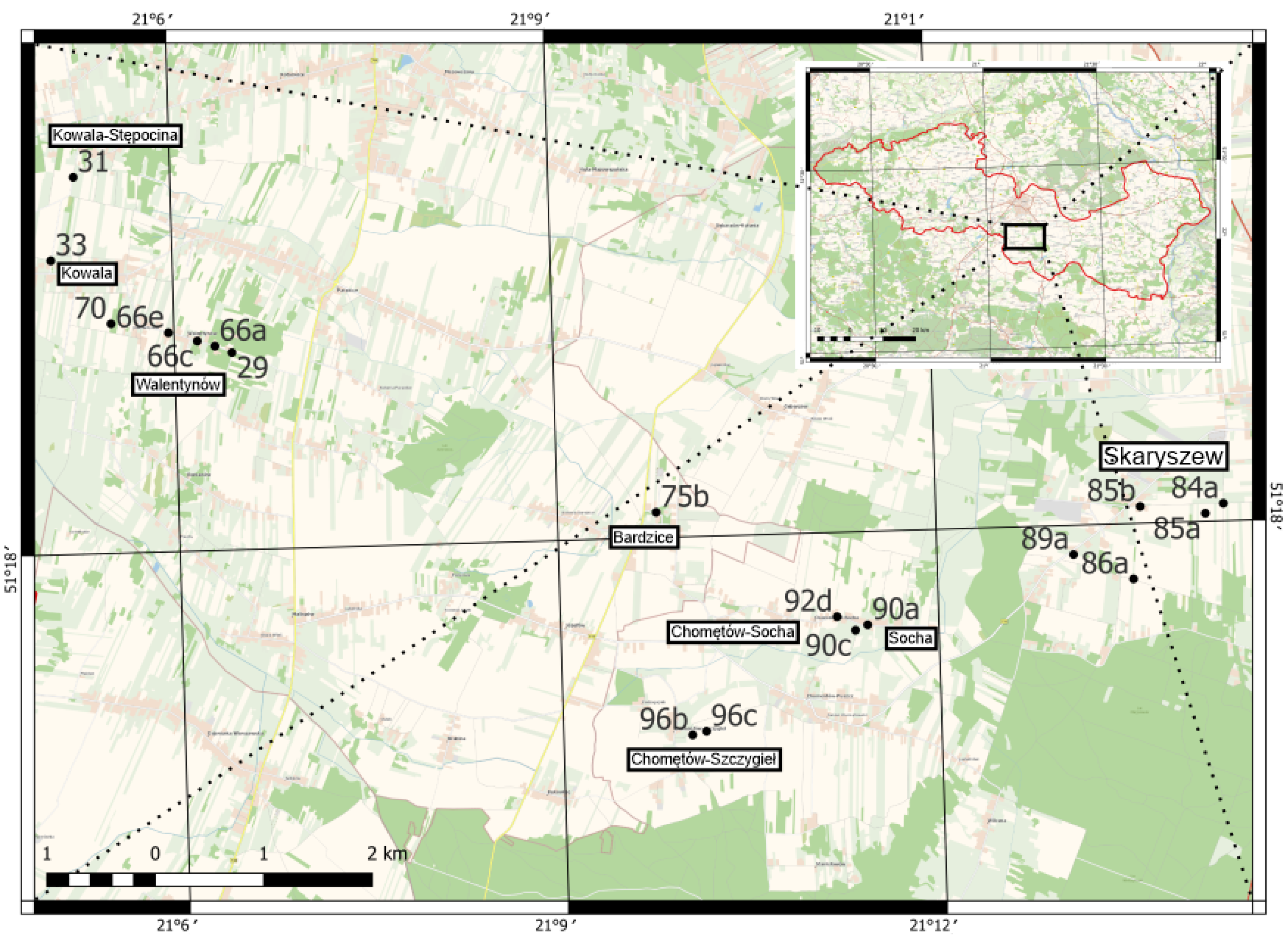

 Småland granites (Nos.: 29, 31, 66c, 66e, 86a, 89a, 96c).
  Åland granites rapakivi (Nos.: 33, 75b, 84a, 85b).
  Blekinge granites (Nos.: 85a, 90c).
Småland granites (Nos.: 29, 31, 66c, 66e, 86a, 89a, 96c). Åland granites rapakivi (Nos.: 33, 75b, 84a, 85b). Blekinge granites (Nos.: 85a, 90c).
Blekinge granites (Nos.: 85a, 90c).
Småland granites (Nos.: 29, 31, 66c, 66e, 86a, 89a, 96c). Åland granites rapakivi (Nos.: 33, 75b, 84a, 85b). Blekinge granites (Nos.: 85a, 90c).


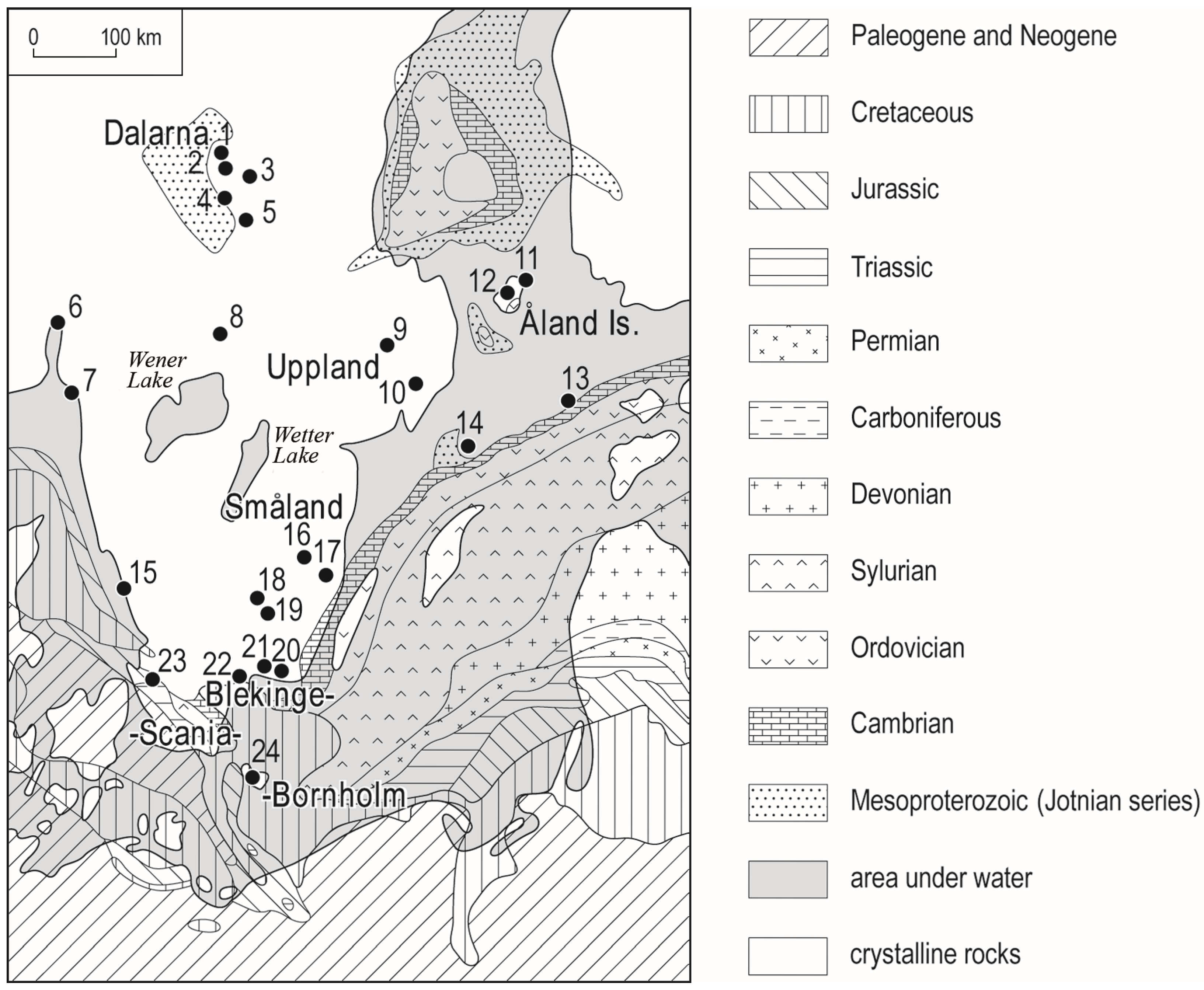
 Småland granites (Nos.: 4, 5, 13, 14). Åland granites rapakivi (Nos.: 10, 11).
Småland granites (Nos.: 4, 5, 13, 14). Åland granites rapakivi (Nos.: 10, 11).
Småland granites (Nos.: 4, 5, 13, 14). Åland granites rapakivi (Nos.: 10, 11).


| No. | Species | Total Number of Boulders (In Brackets—The Boulders Numbers Themselves) |
|---|---|---|
| 1. → | Acarospora fuscata (Schrad.) Arnold | 4 (31, 85a, 90c, 92d) |
| 2. → | Acarospora privigna (Ach.) A. Schneid. | 1 (92d) |
| 3. → | Acarospora versicolor Bagl. & Carestia | 3 (31, 33, 66c) |
| 4. → | Amandinea punctata (Hoffm.) Coppins & Scheid. | 5 (31, 66c, 66e, 90c, 92d) |
| 5. → | Athallia holocarpa (Hoffm.) Arup, Frödén & Søchting | 3 (29, 66c, 92d) |
| 6. → | Bacidina modesta (Zwackh ex Vain.) S. Ekman | 3 (4, 5, 7) |
| 7. → | Calogaya decipiens (Arnold) Arup, Frödén & Søchting | 3 (31, 66c, 89a) |
| 8. → | Calogaya saxicola (Hoffm.) Vondrák | 2 (66c, 89a) |
| 9. → | Candelariella aurella (Hoffm.) Zahlbr. | 15 (13, 14, 31, 33, 66a, 66c, 66e, 84a, 85b, 89a, 90a, 90c, 92d, 96b, 96c) |
| 10. → | Candelariella vitellina (Hoffm.) Müll.Arg. | 11 (31, 33, 66c, 66e, 84a, 85a, 89a, 90a, 90c, 92d, 96c) |
| 11. → | Circinaria caesiocinerea (Nyl. ex Malbr.) A. Nordin, S. Savić & Tibell | 4 (11, 31, 66e, 90c) |
| 12. → | Cladonia coniocraea (Flörke) Spreng. | 2 (7, 13) |
| 13. → | Flavoplaca flavocitrina (Nyl.) Arup, Frödén & Søchting | 1 (90a) |
| 14. → | Hypogymnia physodes (L.) Nyl. | 1 (66a) |
| 15. → | Hypogymnia tubulosa (Schaer.) Hav. | 1 (66a) |
| 16. → | Lecidella stigmatea (Ach.) Hertel & Leuckert | 2 (33, 66e) |
| 17. → | Lepraria elobata Tønsberg | 1 (11) |
| 18. → | Lepraria incana (L.) Ach. | 1 (11) |
| 19. → | Micarea viridileprosa Coppins & van den Boom | 2 (4, 7) |
| 20. → | Myriolecis albescens (Hoffm.) Śliwa, Zhao Xin & Lumbsch | 8 (10, 11, 14, 31, 66e, 84a, 85a, 96c) |
| 21. → | Myriolecis crenulata (Hook.) Śliwa, Zhao Xin & Lumbsch | 4 (31, 66c, 90c, 92d) |
| 22. → | Myriolecis dispersa (Pers.) Śliwa, Zhao Xin & Lumbsch | 8 (31, 84a, 85a, 85b, 86a, 90a, 90c, 92d) |
| 23. → | Myriolecis hagenii (Ach.) Śliwa, Zhao Xin & Lumbsch | 1 (14) |
| 24. → | Myriolecis semipallida (H. Magn.) Śliwa, Zhao Xin & Lumbsch | 11 (13, 14, 29, 31, 33, 66c, 66e, 85a, 85b, 90a, 90c) |
| 25. → | Parmelia sulcata Taylor | 4 (13, 66a, 66c, 96c) |
| 26. → | Phaeophyscia nigricans (Flörke) Moberg | 8 (29, 31, 66c, 84a, 85b, 89a, 92d, 96c) |
| 27. → | Phaeophyscia orbicularis (Neck.) Moberg | 13 (10, 14, 29, 31, 66a, 66c, 84a, 85b, 86a, 89a, 90a, 92d, 96c) |
| 28. → | Physcia adscendens (Fr.) H. Olivier | 10 (13, 14, 29, 31, 66a, 66c, 84a, 85a, 85b, 86a) |
| 29. → | Physcia dubia (Hoffm.) Lettau | 1 (66a) |
| 30. → | Physcia caesia (Hoffm.) Fürnrohr | 4 (13, 14, 31, 66a) |
| 31. → | Physcia tenella (Scop.) DC. | 9 (10, 13, 14, 29, 31, 66a, 66c, 85b, 96c) |
| 32. → | Placynthiella icmalea (Ach.) Coppins & P. James | 1 (7) |
| 33. → | Porina chlorotica (Ach.) Müll.Arg. | 3 (4, 5, 7) |
| 34. → | Porpidia crustulata (Ach.) Hertel & Knoph | 1 (13) |
| 35. → | Porpidia soredizodes (Lamy) J.R. Laundon | 3 (11, 13, 66e) |
| 36. → | Protoparmeliopsis muralis (Schreb.) M. Choisy | 13 (13, 14, 31, 33, 66c, 66e, 84a, 85a, 89a, 90c, 92d, 96b, 96c) |
| 37. → | Rhizocarpon distinctum Th.Fr. | 1 (66e) |
| 38. → | Rinodina sp. | 2 (31, 33) |
| 39. → | Scoliciosporum umbrinum (Ach.) Arnold | 5 (66a, 66e, 70, 75b, 96c) |
| 40. → | Xanthoparmelia conspersa (Ach.) Hale | 2 (13, 33) |
| 41. → | Xanthoria parietina (L.) Th.Fr. | 10 (14, 29, 31, 66a, 66c, 84a, 86a, 90a, 92d, 96c) |
| 42. → | Verrucaria sp. 1 | 13 (4, 7, 14, 70, 75b, 84a, 85a, 85b, 86a, 90a, 92d, 96b, 96c) |
| 43. → | Verrucaria sp. 2 | 1 (85b) |
| No of the Boulder | Site | Coordinates | Vol. [m3], Weight [t], age [Ga] | Petrographical Type, Kind of an Erratic | Specific Features of the Boulder Morphology | Currently Secured Geosystem Services |
|---|---|---|---|---|---|---|
| 29 | Walentynów | 51.316364 21.107587 | 0.19 0.52 1.75–1.5 | Igneous, indicator erratic, Småland granite | Granite with an eolised surface, visible from the cross road; protects the place name sign from being hit by vehicles | Regulation, support, provisioning, cultural and knowledge services |
| 31 | Kowala-Stępocina | 51.331264 21.087253 | 0.23 0.64 1.75–1.5 | Igneous, indicator erratic, Småland granite | Granite, poorly weathered in places, located on a bend, together with other smaller boulders, prevents vehicles from stopping on the grassy verge | Regulation, support, provisioning, cultural and knowledge services |
| 33 | Kowala | 51.324395 21.08398 | 0.39 1.07 1.7–1.54 | Igneous, indicator erratic, Åland rapakivi granite | Granite with a glacial polish on the south-western side, with a clear eolian corrasion micro-relief; it serves as protection for the signpost; locally, the boulder is known as the ‘Wooden Stone’ | Regulation, support, provisioning, cultural and knowledge services |
| 66a | Walentynów | 51.31694 21.10536 | 0.34 0.94 difficult to assess | Igneous on a contact with metamorphic zone | The granitoid gneiss lies in the vicinity of other erratic boulders (including pebbles) on the edge of the forest next to the buildings of Walentynów; colonisation by lichens prevents accurate petrographic identification | Regulation, support, provisioning and knowledge services |
| 66c | Walentynów | 51.3174 21.10305 | 0.06 0.16 1.75–1.5 | Igneous, indicator erratic, Småland granite | Granite with glacial polish of a small area; located where the Radom City Tourist Walking Trail runs, Polish Tourist and Sightseeing Society Łucznik Branch (lucznik.org.pl); the boulder (sentimental value?) has been marked with the number (12) of the property at Walentynowska St | Regulation, support, provisioning, cultural and knowledge services |
| 66e | Walentynów | 51.31815 21.09926 | 0.15 0.40 1.75–1.5 | Igneous, indicator erratic, Småland granite | Partially weathered granite, with glacial polish still visible on the western wall; located along the road in front of a new residential building; dates back to the time when the foundations were laid | Regulation, support, provisioning, cultural and knowledge services |
| 70 | Walentynów | 51.319031 21.091703 | 0.03 0.09 difficult to assess | Igneous, fine-grained granite | Granite with a glacially smoothed surface on the south-western side and rounded corners and edges, with slight eolisation of the surface in places; located in a small forest, next to the blue tourist and sightseeing trail | Regulation, support, provisioning and knowledge services |
| 75b | Bardzice | 51.30211 21.16305 | 2.67 7.34 1.75–1.5 | Igneous, indicator erratic, Åland pyterlite granite | The granite is heavily weathered, partly due to exfoliation; glacial polish is visible on one of the walls; despite the anthropogenic cutting of a fragment of the boulder, it stands in front of the Church of St. Andrew Bobola in Bardzice and commemorates a historical event—the establishment of the parish in 1943 | Regulation, support, provisioning, cultural and knowledge services |
| 84a | Skaryszew | 51.30145 21.23805 | 0.18 0.49 1.7–1.54 | Igneous, indicator erratic, Åland rapakivi granite | The granite lying on the boundary next to the tree marks a crossroads of dirt roads; it is a boulder with rounded corners and edges | Support, provisioning, cultural and knowledge services |
| 85a | Skaryszew | 51.30067 21.23564 | 0.07 0.20 1.46–1.35 | Igneous, indicator erratic, Blekinge granite | Heavily weathered granite lies in a clump of trees in the middle of a agricultural land | Support, provisioning and knowledge services |
| 85b | Skaryszew | 51.3014 21.22705 | 0.13 0.37 1.7–1.54 | Igneous, indicator erratic, Åland granite | Granite, on the private property of an engraving craftsman at 47 Partyzantów St, lies anchored in the ground | Support, provisioning, cultural and knowledge services |
| 86a | Skaryszew | 51.29541 21.22588 | 0.09 0.26 1.75–1.5 | Igneous, indicator erratic, Småland granite | Granite with a glacial polish surface visible in the upper part of the specimen; weathered, including chemically on feldspar crystals | Regulation, support, provisioning and knowledge services |
| 89a | Skaryszew | 51.29758 21.21805 | 0.10 0.26 1.75–1.5 | Igneous, indicator erratic, Småland granite | Granite with distinct glacial wear on corners and edges; lying against the wall of farm buildings on the field side | Regulation, support, provisioning and knowledge services |
| 90a | Socha | 51.29227 21.19057 | 0.02 0.06 difficult to assess | Igneous, granite with a vein | Granite with veins, with rounded edges, slight surface weathering in places | Regulation, support, provisioning and knowledge services |
| 90c | Chomętów-Socha | 51.29185 21.18894 | 0.51 1.41 1.46–1.35 | Igneous, indicator erratic, Blekinge granite | The large single granite boulder is characterised by delicate eolisation of the surface on the south side, emphasised by the presence of microforms of wind erosion; the surface of the rock is subject to exfoliation; the erratic boulder is located in a local recreation area, i.e. a place dedicated to bonfires (fire pit, shelter, swing, benches, small pond); the fire pit is marked with smaller Scandinavian pebbles | Regulation, support, provisioning, cultural and knowledge services |
| 92d | Chomętów-Socha | 51.29246 21.18745 | 0.58 1,59 difficult to assess | Granitoid gneiss | A boulder not exposed, located in farm waste, behind buildings | Regulation, support, provisioning and knowledge services |
| 96b | Chomętów-Szczygieł | 51.28358 21.16701 | 0.03 0.10 difficult to assess | Igneous, fine-grained granite | Partially weathered granite lies on the boundary between fields; next to it is another, smaller coarse-grained granite | Regulation, support, provisioning and knowledge services |
| 96c | Chomętów-Szczygieł | 51.28385 21.16887 | 0.05 0.14 1.75–1.5 | Igneous, indicator erratic, Småland granite | Granite removed from agricultural land now lies on the boundary between fields | Regulation, support, provisioning and knowledge services |
| No of the Boulder | Site | Coordinates | Vol. [m3], Weight [t], Age [Ga] | Petrographical Type, Kind of an Erratic | Specific Features of the Boulder Morphology | Currently Secured Geosystem Services |
|---|---|---|---|---|---|---|
| 4 | Rytwiany, Forest Hermitage of Our Lady of Fatima | 50.525528 21.235333 | 0.44 1.21 1.75-1.5 | Igneous, indicator erratic, Småland granite | Coarse-grained granite, rounded corners | Regulation, provisioning, cultural and knowledge services |
| 5 | 0.29 0.79 1.75-1.5 | Igneous, indicator erratic, Småland granite | Coarse-grained granite, strongly exfoliated, with slightly visible glacial scratches | Regulation, support, provisioning, cultural and knowledge services | ||
| 7 | Pliskowola | 50.526389 21.370889 | 1.13 3.11 difficult to assess | Metamorphic, gneiss | Gneiss with veins, located in the bushes behind the local forest district sign, anthropogenically damaged - there are four smaller fragments of this boulder nearby | Regulation, support, provisioning and knowledge services |
| 10 | Wiśniowa | 50.58896 21.25804 | 0.96 2.64 1.7-1.54 | Igneous, indicator erratic, Åland rapakivi granite | The granite lies centrally in the lawn in front of the property on the roadside, surrounded by flowering plants, with parts of its surface eolian polished, showing signs of exfoliation | Regulation, support, provisioning, cultural and knowledge services |
| 11 | 0.22 0.61 1.7-1.54 | Igneous, indicator erratic, Åland rapakivi granite | The smaller granite lies on the side of the residential building, with glacially rounded corners and edges | Regulation, provisioning, cultural and knowledge services | ||
| 13 | Kopanina | 50.595361 21.169000 | 2.25 6.2 1.46-1.35 | Igneous, indicator erratic, Småland granite | Weathered granite, heavily eolised, with distinct corrasive micro-relief in places, exfoliation present on fragments of the surface; intentionally transported from the immediate vicinity to the property | Regulation, provisioning, support and knowledge services |
| 14 | Kotuszów | 50.603607 21.056708 | 1,19 3.27 1.75-1.5 | Igneous, indicator erratic, Småland granite | Granite shows strong weathering | Support, provisioning and knowledge services |
Disclaimer/Publisher’s Note: The statements, opinions and data contained in all publications are solely those of the individual author(s) and contributor(s) and not of MDPI and/or the editor(s). MDPI and/or the editor(s) disclaim responsibility for any injury to people or property resulting from any ideas, methods, instructions or products referred to in the content. |
© 2025 by the authors. Licensee MDPI, Basel, Switzerland. This article is an open access article distributed under the terms and conditions of the Creative Commons Attribution (CC BY) license (https://creativecommons.org/licenses/by/4.0/).
Share and Cite
Górska-Zabielska, M.; Łubek, A. Geosystem Services of Erratic Boulders in Selected Regions of Central Poland. Resources 2025, 14, 99. https://doi.org/10.3390/resources14060099
Górska-Zabielska M, Łubek A. Geosystem Services of Erratic Boulders in Selected Regions of Central Poland. Resources. 2025; 14(6):99. https://doi.org/10.3390/resources14060099
Chicago/Turabian StyleGórska-Zabielska, Maria, and Anna Łubek. 2025. "Geosystem Services of Erratic Boulders in Selected Regions of Central Poland" Resources 14, no. 6: 99. https://doi.org/10.3390/resources14060099
APA StyleGórska-Zabielska, M., & Łubek, A. (2025). Geosystem Services of Erratic Boulders in Selected Regions of Central Poland. Resources, 14(6), 99. https://doi.org/10.3390/resources14060099