1. Introduction
Urban transportation systems in many regions have become increasingly exposed to heavy rainfall events. According to meteorological classification standards, rainfall events with hourly precipitation exceeding 16 mm/h, or cumulative precipitation exceeding 50 mm within 24 h, are generally classified as heavy rainfall events [
1]. Such intense rainfall usually leads to a reduction in road capacity, which can cause non-recurrent congestion and increase travel delay and traffic safety risks. Urban road networks operate as large-scale interconnected systems, whose macroscopic traffic states emerge from the interaction between travel demand, infrastructure supply, and operational control. Consequently, traffic management often manifests as a ‘wicked problem’ that necessitates multi-level governance structures to coordinate the complex interactions between physical infrastructure and operational decision-making [
2]. In many cases, existing urban drainage systems are not sufficient to deal with extreme rainfall intensity. For example, during July and August 2023, a total of 37 regional heavy rainfall events in China resulted in serious waterlogging and interruption of urban road connections [
3], while the catastrophic “7·20” Zhengzhou rainstorm in 2021 resulted in gridlock and significant casualties [
4]. Similar impacts have also been observed in other countries, such as the floods in Western Europe in 2021 and the highway closures during Storm “Elias” in Greece in 2024 [
5,
6]. These events indicate that heavy rainfall does not merely act as a short-term traffic disturbance, but can change the macroscopic operating characteristics and recovery processes of urban traffic systems by altering effective network capacity.
Over the past decade, perimeter control strategies based on macroscopic fundamental diagrams (MFD) have been widely applied for urban congestion management. By regulating boundary inflows according to aggregated traffic states, these strategies aim to maintain overall network operation within an efficient range. Although these control methods, such as PID, model predictive control (MPC), and robust control, have demonstrated measurable improvements in network stability and queue reduction when addressing conventional traffic demand fluctuations [
7,
8]. For instance, recent studies have optimized path planning by explicitly modeling periodic queuing delays that can reduce total travel time by up to 25.36%, leading to improved traffic efficiency and reduced congestion propagation [
9], and have enhanced traffic forecasting accuracy by capturing dynamic spatiotemporal interactions through dynamic relational graphs, thereby improving short-term traffic state estimation reliability [
10]. However, most existing control frameworks are developed under the assumption that road capacity is constant over time. They primarily focus on changes in demand while neglecting the reduction in capacity caused by external disturbances such as rainfall [
11,
12]. Although some studies have discussed rainfall influence, many of them focus on highway corridors, where traffic dynamics are different from urban road networks [
13,
14]. In addition, most existing work is based on offline analysis using historical data, while the system-level response of urban traffic networks to rainfall-induced capacity degradation and recovery dynamics remains insufficiently explored.
In this context, the impact of heavy rainfall on urban traffic networks is not limited to a reduction in average capacity, but is more prominently reflected in rapid temporal and spatial variations in road supply. In real operation, road capacity may change with accumulated water depth, and different boundary entrances can be affected at different levels. In this case, perimeter control strategies with fixed parameters or offline calibration are difficult to adjust to such environmental changes in time. This may result in delayed inflow restrictions at some boundaries, or local overload in specific areas, allowing localized congestion to propagate through the network and destabilize the overall system operation.
To mitigate non-recurrent congestion under heavy rainfall, this study proposes an adaptive perimeter control strategy that explicitly incorporates rainfall-related disturbances within the operational context of urban traffic networks. Real taxi trajectory data are used to characterize traffic operating states under rainfall conditions, and the impact of rainfall on road capacity is embedded into the MFD formulation. Based on this formulation, a two-layer distributed coordinated perimeter control framework is developed, consisting of a global controller and multiple local boundary controllers. Within this framework, control parameters are updated according to real-time traffic states and rainfall-related indicators, enabling coordinated adjustments of boundary inflows under dynamically changing capacity conditions. Case studies based on microscopic traffic simulation are conducted to evaluate the effectiveness of the proposed approach.
This study focuses on how urban traffic systems respond to rainfall-induced capacity degradation and how distributed perimeter regulation can improve system stability and congestion mitigation under such disturbances. By introducing a two-layer distributed coordinated control structure, the proposed framework reflects the interaction between global traffic regulation and localized capacity degradation, thereby enhancing the ability of the urban traffic system to maintain stable operation and recover from congestion under heavy rainfall conditions. The contributions of this study can be summarized as follows:
- (1)
Urban traffic networks under heavy rainfall are formulated as disturbance-driven complex systems, in which external environmental shocks alter macroscopic operating regimes. Within this context, a distributed coordinated perimeter control framework is employed to characterize how urban traffic systems coordinate network-level regulation and localized capacity degradation under rainfall-induced disturbances.
- (2)
Rainfall-induced water depth is explicitly integrated into the distributed control framework as a dynamic feedback variable, allowing supply-side capacity degradation to be actively compensated alongside macroscopic traffic accumulation. This distinguishes the proposed approach from general adaptive control strategies that typically rely solely on aggregate traffic state errors. By embedding real-time capacity dynamics into the sub-controller logic, the framework enables rainfall effects to be treated as an intrinsic component of traffic system dynamics rather than as exogenous perturbations.
- (3)
The congestion evolution and recovery processes of urban road networks under heavy rainfall are examined through microscopic traffic simulation, revealing how coordinated multi-layer regulation can suppress congestion propagation and accelerate post-disturbance recovery. The results demonstrate that the proposed framework significantly enhances network resilience against extreme weather events, validating its superior stability and responsiveness compared to conventional control strategies.
The rest of this paper is structured as follows:
Section 2 provides an overview of perimeter control and related MFD research;
Section 3 introduces the rainfall-affected MFD model and the distributed coordinated adaptive PID controller;
Section 4 validates the effectiveness of the strategy through a case study of a two-region urban network;
Section 5 discusses the research findings and limitations; and
Section 6 concludes the paper.
2. Literature Review
To provide the theoretical foundation for the proposed rainfall-responsive perimeter control framework, this section reviews the key research developments related to macroscopic traffic modeling and network-level control strategies. In particular, the macroscopic fundamental diagram (MFD) is introduced as a fundamental tool for describing aggregated urban traffic dynamics, while perimeter control is discussed as an effective network-level regulation strategy for congestion mitigation. By summarizing existing MFD-based traffic modeling approaches and perimeter control methodologies, this section establishes the research background for analyzing traffic system behavior under external disturbances.
2.1. Macroscopic Fundamental Diagram (MFD)
The concept of the Macroscopic Fundamental Diagram (MFD) was first proposed by Godfrey [
15], but it initially received limited attention. It was not until Geroliminis and Daganzo [
16] used real-world urban traffic data to first confirm the existence of the Davanzo MFD in real road networks that the concept truly entered mainstream research. Building on this empirical validation, Daganzo and Geroliminis [
17] proposed an approximate method for calculating the MFD, providing a feasible way to simplify the representation of large-scale traffic dynamics. However, the application of the MFD still has some limitations. Buisson and Ladier [
18] noted that its accuracy is closely related to the uniformity of traffic, and when obvious spatial heterogeneity occurs, the macroscopic regularity of the MFD will be weakened to some extent. Unlike studies focusing only on traffic states, Geroliminis and Sun [
19] explored this problem from a structural perspective, investigating the impact of road network structure on the stability of the MFD. These results indicate that although the MFD can describe the relationship among flow, density, and speed at a macroscopic level, its reliability is still closely related with traffic conditions and network characteristics.
With the gradual development of the MFD concept, research interest has shifted from merely verifying its existence to examining its shape and internal mechanism. Ji and Geroliminis [
20] pointed out that the way of spatial division of the urban road network has a strong influence on the uniformity of traffic conditions within a region, and such uniformity is usually regarded as an important requirement for MFD validity. Regarding the parameter estimation issue, Leclercq et al. [
21] compared different calibration methods and found that results obtained in practice often deviate from theoretical assumptions; therefore, empirical adjustment of parameters is often needed. Aghamohammadi and Laval [
22] tried to apply maximum likelihood estimation to identify MFD parameters, aiming to improve statistical rigor, while Batista et al. [
23] challenged the traditional understanding that travel distance is a secondary variable, and showed that it can also have a clear impact on the MFD curve. These studies help the MFD go beyond a purely empirical observation and make it more useful for theoretical analysis, although some assumptions still remain strong.
The solidification of the theoretical foundation established the core position of the MFD in congestion propagation modeling and road network control. The early application of the MFD mainly focused on perimeter control, that is, regulating the boundary flux to maintain the unsaturated state of the protected area. The related research covered everything from system stability theory analysis [
24] to traffic flow optimization based on MPC [
7]. Subsequently, the application boundaries of this framework have been significantly extended, no longer limited to single control: Zheng et al. [
25] used it for dynamic regional congestion charging, Ramezani et al. [
26] explored a hierarchical collaborative control architecture, and Haddad and Shraiber [
27] studied the robust optimization problem under demand uncertainty.
In recent years, in response to the increasingly complex urban road network, the research focus has gradually shifted towards adaptive methods and data-driven approaches. Ambühl et al. [
28] introduced seepage theory into the MFD system and attempted to analyze the underlying mechanism of congestion propagation at the network topology level. To improve control flexibility and handle network heterogeneity, Li et al. [
29] advanced adaptive perimeter control methods to tackle boundary queuing issues. The location-varying cordon design proposed by Li et al. [
30] provides a new idea for real-time operational adjustment. At the application level of large-scale road networks, Sirmatel and Geroliminis [
31] utilized MPC to achieve stable control of large heterogeneous road networks, and Ding et al. [
32] constructed an integrated control framework for trunk roads and expressways. Huang et al. [
33] prospectively studied the impact of autonomous vehicles on the structural properties of MFDs.
Although MFDs have proven effective in describing aggregated traffic dynamics and informing road network-level control strategies, current research is generally based on the ideal assumption of constant capacity under clear weather conditions. As a result, the impact of supply-side disturbances, particularly the capacity reduction caused by extreme weather, is often overlooked.
2.2. Perimeter Control
Perimeter control strategy based on MFDs has been widely applied to suppress the supersaturated state of urban road networks. Fundamentally, this strategy works by regulating traffic inflow through signal timing adjustments or gating at boundary intersections. The objective is to maintain vehicle accumulation within the region near a critical threshold. Theoretically, stabilizing operations at this level allows the system to maintain high traffic efficiency while preventing large-scale congestion. Geroliminis and Daganzo [
17] first formalized this concept. They constructed a framework coupling regional accumulation and outflow, which enabled modeling and control at the aggregate level for the first time. Building on this foundation, subsequent studies [
24,
34] extended the approach to boundary flow regulation, establishing both the theoretical and practical basis for perimeter control.
The development of perimeter control has significantly progressed over the past decade. Early research mainly focused on centralized frameworks, including PI controllers and MPC. These methods proved effective in reducing recurring congestion and increasing overall efficiency [
7]. In addition to MPC-based approaches, several studies have explored PID-type perimeter control for MFD-based perimeter control. For incident-affected networks, Wang et al. [
35] embed a single-loop PID to dampen spikes in gated inflows while tracking an online maximum-throughput target, stabilizing accumulation near the critical point. At the multi-region scale, Mercader and Haddad [
36] propose a resilient MIMO-PID with derivative low-pass filtering and anti-windup, maintaining performance even under deception/DoS cyberattacks. In the direction of intelligent tuning, Yang et al. [
37] propose a fuzzy-RBF-tuned (FR-PID) that adjusts
,
,
online and reports improvements over pre-timed and fuzzy-PID baselines. Overall, PID remains less common than PI due to noise/delay sensitivity at the cordon, but it is attractive where fast disturbance rejection and real-time implementability are paramount.
However, their dependence on accurate global models and high computational requirements limits their scalability and robustness in large networks. Therefore, the research trend has gradually shifted from a single centralized approach to a more adaptive hierarchical control architecture. For instance, Haddad and Mirkin [
38] designed a master-slave controller structure. Through the division of labor between upper-level coordination and lower-level execution, it effectively resolves the coupling relationship between global decision-making and local response, alleviating the burden of centralized decision-making. Ding et al. [
39] constructed a decentralized collaboration mechanism based on MFD, enabling adjacent sub-regions to dynamically negotiate boundary inflows according to local information. Although these two strategies work in different ways, they still have some similar characteristics. Either through hierarchical coordination or distributed negotiation, the stability of the traffic network can be maintained, and this process does not strongly rely on complete global information.
To overcome limitations of a single control strategy, research in recent years has begun to combine perimeter control with other traffic management methods. Ding et al. [
40] integrated path guidance and perimeter control in a hybrid framework, while Fu et al. [
41] modeled their interaction using colored Petri nets. Both studies observed improved network traffic efficiency in simulations. However, most existing methods assume a stable system structure and do not adequately consider the increasingly prominent safety and scalability issues of large-scale road networks. For instance, networked control systems may suffer from oscillation caused by communication interference or even potential cyber-attacks. Similarly, unreasonable regional partitioning will also reduce the effectiveness of the control strategy. To solve these problems, Mercader and Haddad [
36] proposed a multivariable robust controller to suppress disturbance propagation in the network, while Haghbayan et al. [
42] focused on network topology and adopted a community detection method to optimize control partitioning, attempting to improve the controllability of large-scale systems from a more fundamental level.
With the increasing complexity of the traffic environment, especially the uncertainty brought by mixed traffic flow composed of HDVs and CAVs, research focus in recent years has gradually shifted to multi-level and more intelligent perimeter control strategies. Zhou et al. [
43] demonstrate that model-free deep reinforcement learning has good flexibility in dealing with both continuous and discrete action spaces, and this work provides a basis for later agent-based control studies. Building on this, Ding et al. [
39] further proposed a hierarchical control architecture to address boundary congestion problems in mixed connected and human-driven traffic. From another perspective, Hamedmoghadam et al. [
44] studied the problem from a physical mechanism and used percolation theory to identify the critical congestion threshold in the road network, thereby suppressing congestion spreading in advance. However, these intelligent control methods still have some difficulties in real applications, such as requirement for large amounts of training data and coordination problems at the local level. In response to these challenges, Chen et al. [
45] tried data-efficient reinforcement learning methods, while Tsitsokas et al. [
46] combined the maximum pressure algorithm with perimeter control, forming a relatively lightweight two-layer adaptive signal control framework.
MFD-based perimeter control has been widely used for regulating recurrent congestion in urban road networks. In most existing studies, the operating condition is usually assumed to be clear weather, under which road supply variations are relatively stable. But in real traffic operations, extreme weather, especially heavy rainfall, can significantly change the effective capacity of the road network. Some empirical studies indicate that water accumulation not only reduces the maximum traffic capacity, but also causes the critical accumulation point of the MFD to shift to a lower level, and the congestion recovery process becomes more delayed. Under such conditions, the perimeter control strategy with fixed parameters may exhibit delayed or inappropriate responses to rainfall disturbances. For this reason, it is necessary to consider water depth as a dynamic feedback variable and introduce it into distributed coordinated control framework, aiming to improve the resilience and adaptive regulation capability of urban traffic networks under heavy rainfall conditions.
3. Methodology
To address the limitations of conventional perimeter control strategies under rainfall-induced capacity degradation, this section presents a rainfall-aware traffic modeling and coordinated control methodology for urban two-region networks. The methodology is primarily based on macroscopic traffic modeling using the MFD framework, which provides the theoretical foundation to characterize the dynamic interaction between traffic accumulation evolution and rainfall-induced capacity variations. On this basis, a distributed coordinated control framework integrating fuzzy adaptive logic is constructed to support robust traffic regulation under time-varying environmental conditions.
3.1. MFD-Based Traffic Flow Model for Multi-Gated Networks
This section formulates a two-region traffic flow model based on MFDs to characterize vehicle accumulation and inter-regional exchanges. The formulation provides a macroscopic system-level representation of urban traffic networks, serving as a basis for coordinated regulation aimed at mitigating congestion under capacity-degrading disturbances.
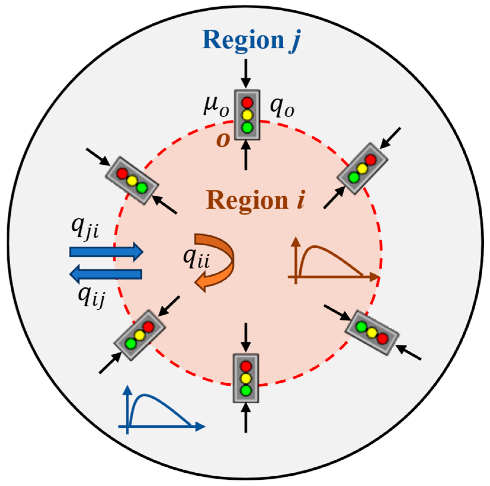
In this study, the urban network is partitioned into two regions (the protected region
and its peripheral region
), each assumed to exhibit homogeneous traffic conditions and a well-defined MFD. We consider a protected network (region
) with an MFD, surrounded by several signalized intersections (controlled gates)
, as illustrated in
Figure 1. The Protected Network (PN) is defined as a specific sub-region within the urban network characterized by high travel demand and a propensity for traffic congestion. By designating such an area as a PN, perimeter control can be implemented at its boundaries to regulate boundary inflows, thereby maintaining traffic accumulation near the critical level and enhancing the system’s ability to withstand external disturbances.
For each region, the vehicle accumulation follows the conservation law. The total vehicle accumulation in a controlled region
at time
, denoted as
, can be considered the sum of two components: the number of vehicles whose trips are completed within region
,
, and the number of vehicles in region
that are destined for region
,
. This can be formally expressed as
The dynamic evolution of vehicle accumulation
within region
at time
can be described by the following conservation equation:
where
is the internal demand flow with the destination within region
;
denotes the index of perimeter gates;
denotes the total inflow entering region
from the peripheral region
via gate
at time
, subject to
(0,1]; and
represents the number of vehicles that have completed their trips within the region
at time
.
The transfer flow
at gate
can be expressed as
where
is the flow distribution coefficient at gate
, and
represents the trip completion rate within region
at time
.
Similarly, the dynamics of vehicle accumulation
can be expressed as
where
represents the newly generated traffic flow from within region
to destination region
due to traffic demand at time
, and
represents the number of completed trips from region
to region
at time
.
Based on the preceding derivations, the dynamics of vehicle accumulation in region
are formulated as
Integrating the equation yields
In the multi-gated network considered, we formulate the regional perimeter control model as an optimization problem. The control objective in Equation (7) is explicitly defined to minimize the deviation of vehicle accumulation in region
from the critical setpoint
to ensure maximum throughput, while penalizing abrupt changes in gate control rates to maintain operational stability. Based on these considerations, we formulate the regional perimeter control model as the following optimization problem:
subject to
and subject to the following constraints:
3.2. Coordinated Distributed Perimeter Controller Design
Heavy rainfall sharply degrades urban road capacity and can trigger sudden local congestion, which disrupts the normal evolution of traffic states in urban networks. From a system perspective, such disturbances introduce strong spatial heterogeneity and temporal instability into the operating states of the network, making congestion management more complex. Under such disturbance conditions, traditional centralized control strategies mainly rely on aggregated network information and therefore have limited ability to respond to sudden local disruptions caused by rainfall. On the other hand, fully decentralized control allows local entrances to react flexibly to local traffic conditions, but it lacks explicit regulation of the total inflow entering the protected network, which may lead to excessive vehicle accumulation at the network level. Therefore, under rainfall disturbance, congestion management in urban traffic systems becomes more complex, as it involves both constraining the total inflow based on network traffic states and adjusting inflows at individual entrances in response to rainfall-induced local disruptions.
To simultaneously address the constraints on total inflow and the response to localized disturbances, this study develops a distributed coordinated control architecture. The architecture includes one main controller and several sub-controllers. The main controller regulates the overall inflow entering the protected network to maintain vehicle accumulation near the critical level, while sub-controllers respond to local traffic conditions and water depth at individual entrances. To explicitly define the interaction mechanism, the system follows a hierarchical data-flow protocol. The main controller computes the total perimeter control rate from the global accumulation error and average water depth. This signal is then decomposed into target inflows for each boundary gate using weighting coefficients and transmitted to the corresponding sub-controllers. Each sub-controller receives its assigned target inflow as a reference signal and regulates the local gating rate by minimizing the tracking error. Its PID gains are further adjusted using local water-depth measurements to adapt to entrance-specific conditions. The resulting control actions are fed back to the network, completing the hierarchical closed-loop process.
This two-layer design is introduced to handle the different spatial scales of traffic dynamics under rainfall. While the main controller focuses on the global balance between demand and reduced capacity, the sub-controllers are responsible for responding to local variations, which are often caused by uneven water accumulation. Such separation allows the system to react to local disturbances without losing overall coordination.
To better illustrate the operation of the coordinated framework, a two-region network shown in
Figure 1 is used as an example. Region
is regarded as the PN, where traffic capacity may decrease during heavy rainfall because of water accumulation. Under this condition, the main control objective of this framework is to regulate boundary inflows and outflows in a dynamic way to avoid excessive vehicle accumulation inside the PN. By applying such regulation, the system can remain in a relatively stable operating state, and congestion dissipation may become faster after rainfall disturbance.
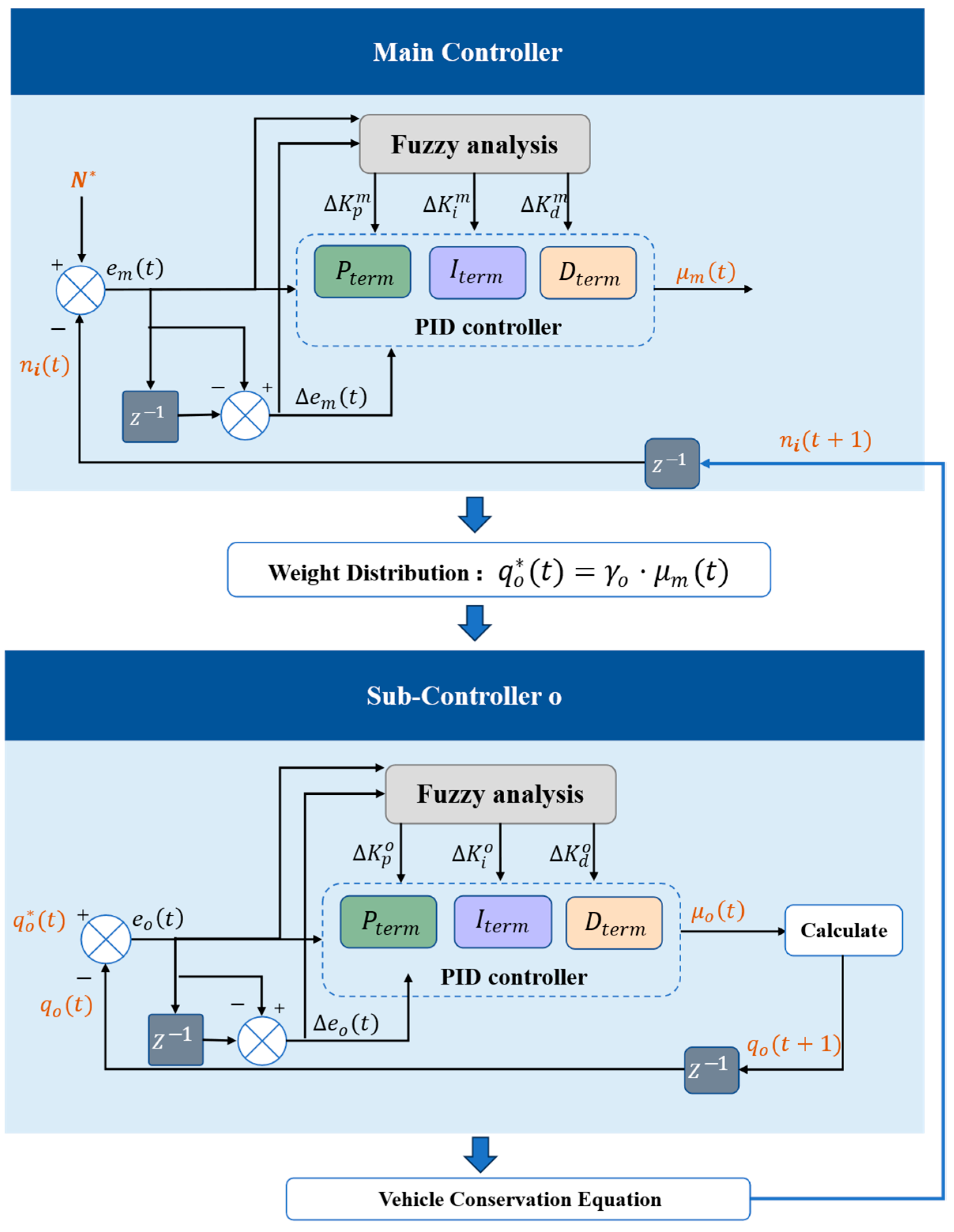
We adopt the PID controller as the foundational control unit. Because of its relatively simple structure and convenient implementation, it has been widely used in the regulation problem of urban traffic systems. However, traditional fixed-gain PID controllers struggle to cope with the nonlinear and time-varying capacity dynamics caused by heavy rainfall. For this reason, a fuzzy inference mechanism is introduced to construct a fuzzy adaptive PID controller. The control gains are updated online according to real-time feedback, achieving an organic unity of global optimization and local disturbance. To coordinate network-level and local control actions, a distributed cooperative control architecture is constructed, as illustrated in
Figure 2. In this hierarchical setting, the main controller stabilizes network-level traffic states, while sub-controllers respond rapidly to localized disturbances such as uneven water accumulation at entrances. This separation of responsibilities allows the control system to simultaneously address global coordination and local disturbances. Such a structure is particularly suitable for spatially heterogeneous disruptions, which are difficult to handle using a single-layer controller.
Within this framework, the main controller is designed to regulate the vehicle accumulation to a setpoint near , which corresponds to the critical accumulation at the peak of the MFD. When accumulation stays near this level, the network throughput is generally high. In real operation, the target value is usually not constant, in particular when rainfall occurs. Therefore, the controller is required to adjust its response to changes in external conditions. In this study, a PID-based structure is adopted, and the control gains are updated online according to the observed traffic state and local water depth. The final output of the main perimeter control rate is dynamically allocated to each sub-controller to coordinate local inflows.
Simultaneously, each sub-controller receives the target inflow rate from the main controller and uses the actual flow at the corresponding entrance as a feedback signal. Through a local adjustment mechanism, it dynamically adjusts the gating rate at that entrance to make the actual inflow approach the allocated target value.
The coordinated control mechanism is formally defined by the mathematical expressions of the main and sub-controllers. The control law of the main controller is given by
where
denotes the deviation between the target vehicle accumulation and the actual accumulation within the PN;
represents the discrete-time change in the error; and
is the total perimeter control signal output by the main controller. It is constrained such that
, and is subsequently allocated to local controllers at each entrance according to predefined weights.
In contrast to conventional PID control with constant gains, the parameters
are dynamically adjusted as functions of both traffic and environmental states:
where
denotes the average water depth on the roads, which characterizes the reduction in road capacity due to flooding.
In the proposed distributed architecture, the main controller is responsible for regulating the overall perimeter inflow of the entire region and allocating this flow to each gate. Correspondingly, a sub-controller is deployed at each gate . Its objective is to track the target inflow (allocated by the main controller) by adjusting the local gate’s perimeter control rate .
The control law for each local controller is expressed as
where
is the deviation between the target and actual inflows at gate
;
reflects the rate of change of this error; and
is the perimeter control rate output by the local controller, constrained by
, and is used to adjust the gate signal release ratio.
Similarly, the PID gain parameters for the sub-controllers are also dynamically adjusted:
The total perimeter control rate
output by the main controller is distributed among the entrances according to the weighting factor
, as shown by the following equations:
4. A Case Study
Wuhan, China, was selected as the case study city due to its pronounced exposure to rainfall-induced urban flooding and the resulting traffic disruptions. As a megacity with a dense road network and consistently high travel demand, Wuhan has repeatedly experienced severe congestion during extreme rainfall events. According to local meteorological reports, from the evening of 29 June to the morning of 30 June 2023, Wuhan experienced heavy to rainstorm-level precipitation, with cumulative rainfall reaching approximately 40–80 mm across most areas and exceeding 150 mm locally, while the maximum hourly rainfall intensity reached approximately 50–70 mm/h. During this rainfall, many urban roads were affected, and traffic congestion became more serious compared with normal conditions. This rainfall event provides an opportunity to observe how external disturbances affect congestion formation and recovery processes in urban traffic systems.
The taxi trajectory dataset contains GPS records from approximately 7500 taxis operating within Jianghan District, Wuhan. The dataset covers two 24 h periods, 27 June 2023 (Tuesday, clear weather) and 29 June 2023 (Thursday, heavy rainfall), both of which are typical weekdays, ensuring comparability of travel demand patterns. The trajectory data were collected through the local taxi GPS monitoring system. Each trajectory record was sampled at a 1 s interval and includes vehicle ID, timestamp, longitude, latitude, heading angle, speed, and operating status. To prevent distortion in macroscopic speed and flow calculations, a multi-criteria state identification procedure was applied to distinguish active traffic movements from non-traffic states. Trajectory points whose operation status was not labeled “vacant”, “occupied”, or “operating” were first removed. For each vehicle trajectory, instantaneous speed and consecutive low-speed duration were then computed. Points with speeds ≤ 5 km/h but lasting ≤ 5 min under occupied or operating status were retained to represent congestion-related traffic conditions. In contrast, points with speed = 0 km/h and duration > 5 min, or points corresponding to non-service states (e.g., long-term parking, waiting at taxi ranks, roadside parking during driver breaks, or refueling), were classified as idle and excluded.
To ensure data quality and reliable traffic state representation, a systematic preprocessing procedure was applied. Trajectory points were first spatially filtered using the Jianghan District boundary. Erroneous records outside the target date were removed to ensure time consistency. Abnormal speed records (speed > 120 km/h or speed < 0) were filtered out. Trajectory continuity filtering was further applied to eliminate GPS jump errors and abnormal long-time gaps. After preprocessing, only valid moving trajectories within the study area were retained for traffic state analysis and MFD calibration.
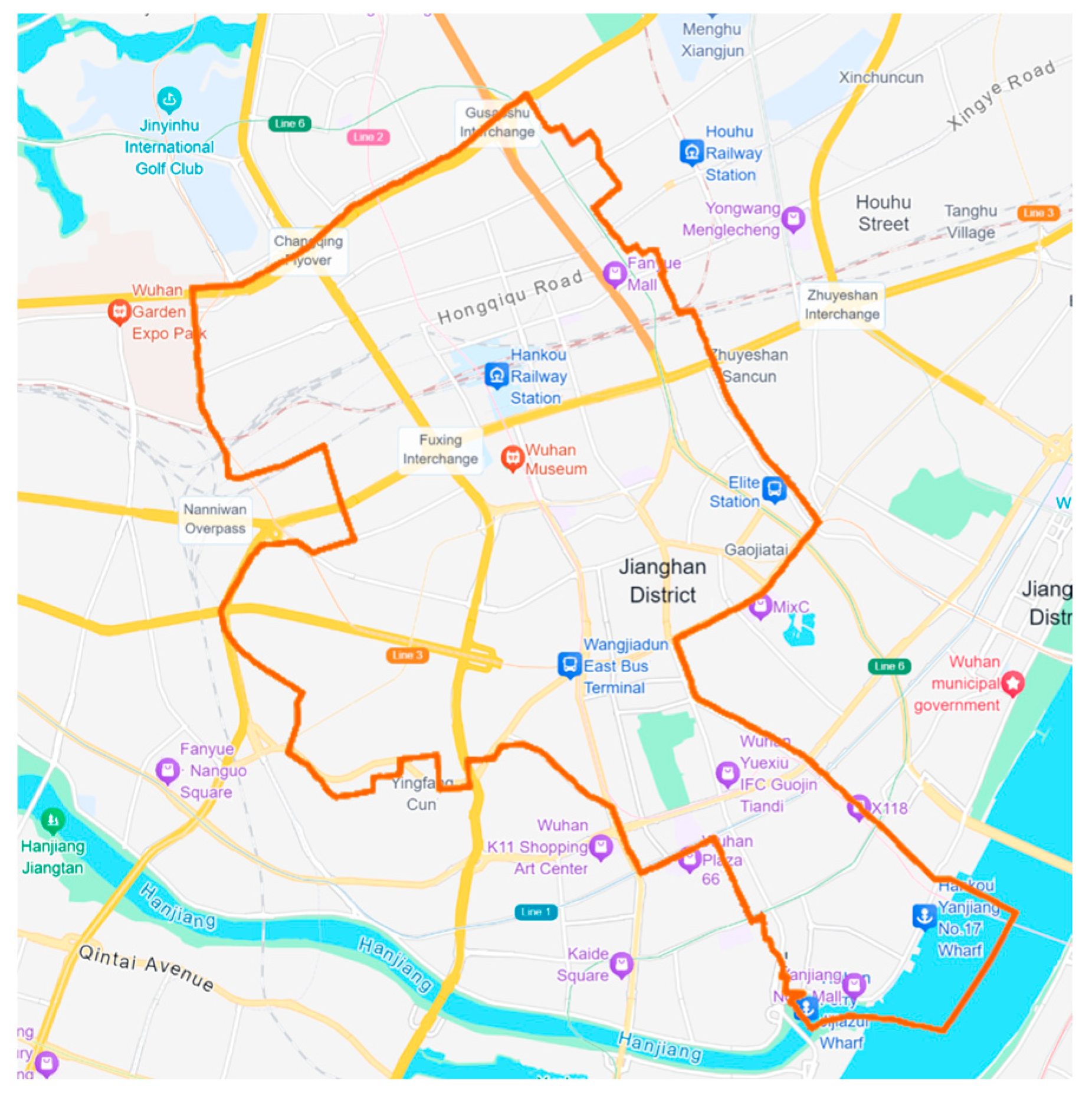
Among the urban districts in Wuhan, Jianghan District was selected as the main study area, as shown in
Figure 3. This district is characterized by relatively high travel demand and a stable network structure at the regional scale, making it suitable for MFD-based analysis. In addition, the selected core area within Jianghan District is designated as the PN, as it exhibits higher congestion vulnerability and stronger sensitivity to rainfall-induced capacity degradation. Under heavy rainfall conditions, this region has been observed to experience rapid performance deterioration and congestion amplification, making it an appropriate target for perimeter control implementation. Based on trajectory data, MFDs under normal weather and heavy rainfall conditions were calibrated. The results are further used to analyze how rainfall affects network capacity and traffic operation performance.
4.1. Impact Analysis of Rainfall Disturbance
To investigate the impact of heavy rainfall on traffic flow, the road network operating conditions in Wuhan City under normal weather (27 June 2023) and heavy rainfall (29 June 2023) were compared. Both dates are typical mid-week weekdays with comparable demand structures, ensuring that differences can be attributed to rainfall rather than day-type variability. Special attention is paid to the changes in network operating state and the congestion recovery behavior under rainfall disturbance. Based on taxi trajectory data, several key indicators were extracted, including average speed, vehicle accumulation in the protected network, and MFD under different weather conditions, which are used to describe the changes in network-level efficiency, stability and congestion evolution.
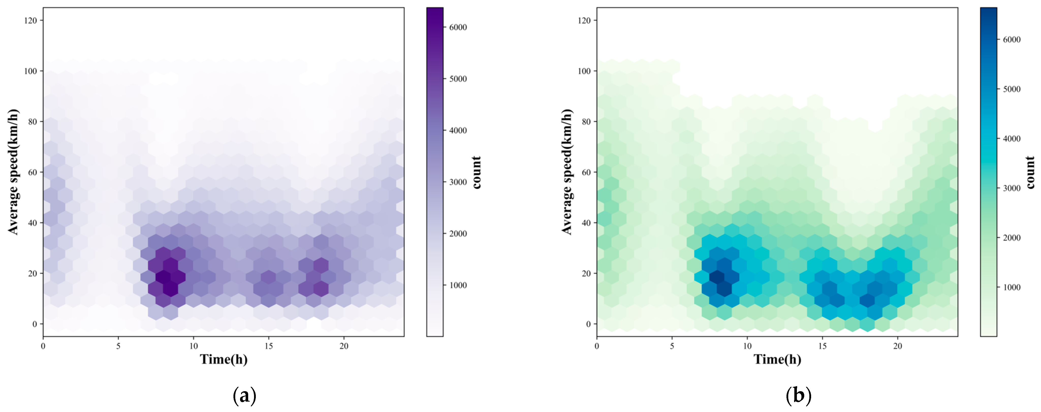
Figure 4 shows the temporal distribution of average vehicle speeds under different weather conditions. Under normal weather (
Figure 4a), low-speed areas (around 15–25 km/h) are mainly observed during the morning peak between 7:00 and 9:00, along with a moderate evening peak around 17:00 to 19:00, and most of the network returns to a relatively normal speed level afterwards. In the heavy rainfall case shown in
Figure 4b, low-speed areas (dropping to roughly 10–20 km/h) appear more frequently and last for a longer period, indicating that a larger portion of the urban road network remains in a degraded operating state for an extended duration. The dark-blue areas indicate that a large number of vehicles are forced to operate at persistently low speeds. Compared with the normal-weather condition, the rainy-day distribution exhibits a denser concentration of low-speed observations and a broader temporal spread, suggesting more persistent network-wide performance degradation under rainfall disturbances.
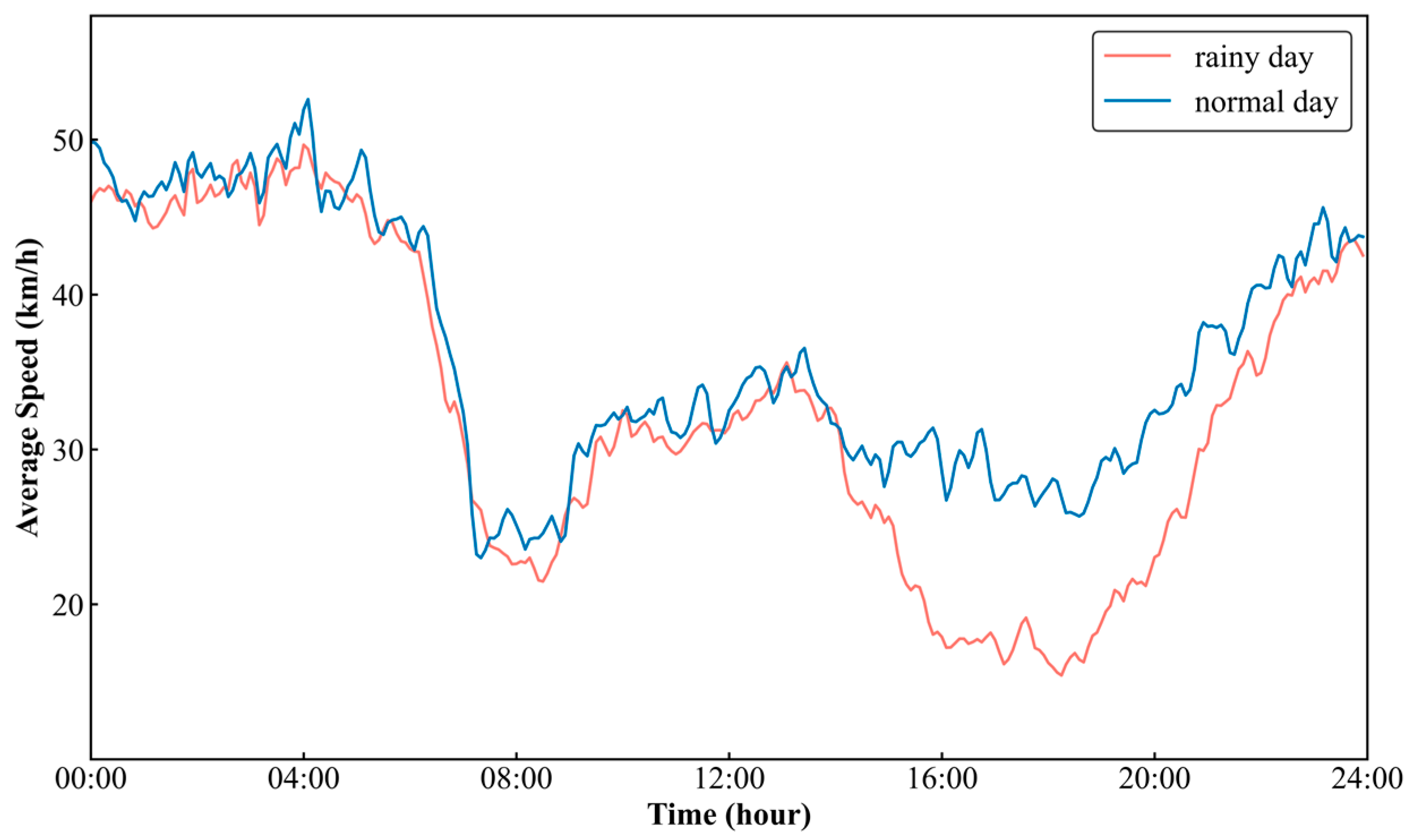
The temporal variation of average network speed is further shown in
Figure 5. On normal days, the daytime operating speed of the network is relatively stable, generally remaining above 25 km/h, while under rainfall the speed is generally lower than that of normal conditions, particularly during peak and afternoon periods. During the evening peak loading period, the average speed under heavy rainfall further drops to around 15–20 km/h and persists at this low level for several hours. In addition, the recovery of traffic speed after congestion is much slower in the case of rainfall, and the slope of the recovery curve is relatively flat, particularly evident during the evening recovery phase, which may be related to factors such as reduced road friction and limited visibility.
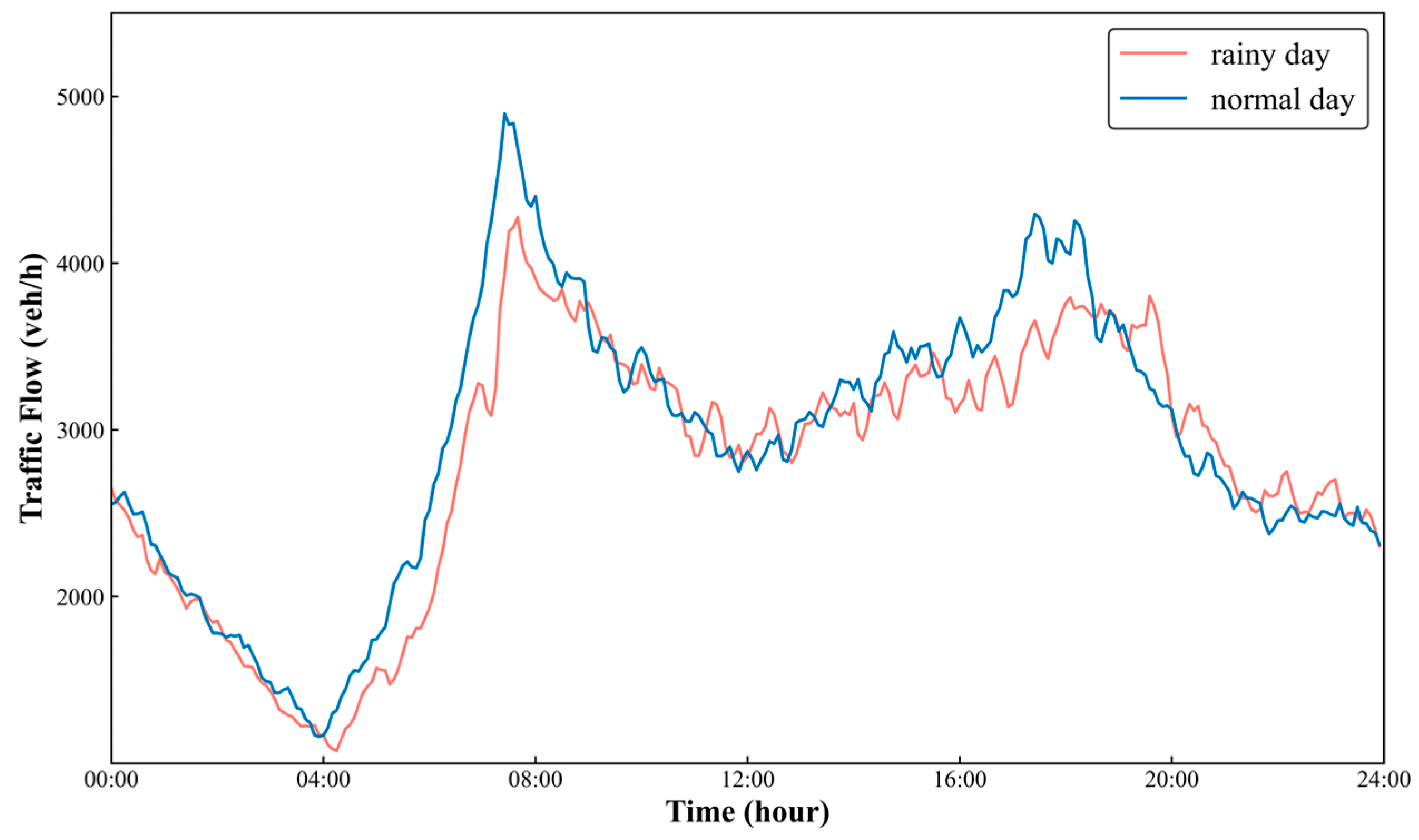
Traffic flow dynamics reveal distinct temporal shifts under rainfall disturbances.
Figure 6 shows the temporal variation of traffic flow under normal weather and heavy rainfall conditions. During heavy rainfall, the typical bimodal peak pattern is obviously weakened and flattened. On normal days, the morning and evening peak flows reach approximately 4900 veh/h and 4300 veh/h, respectively. Under heavy rainfall, these peak volumes decrease significantly to about 4300 veh/h and 3800 veh/h, indicating a notable reduction in active network throughput. In addition, the peak timing remains generally consistent, but the peak intensity is noticeably reduced under rainfall, and the traffic flow stays at a relatively low level during most of the day. This phenomenon may contribute to a slower dissipation of congestion.
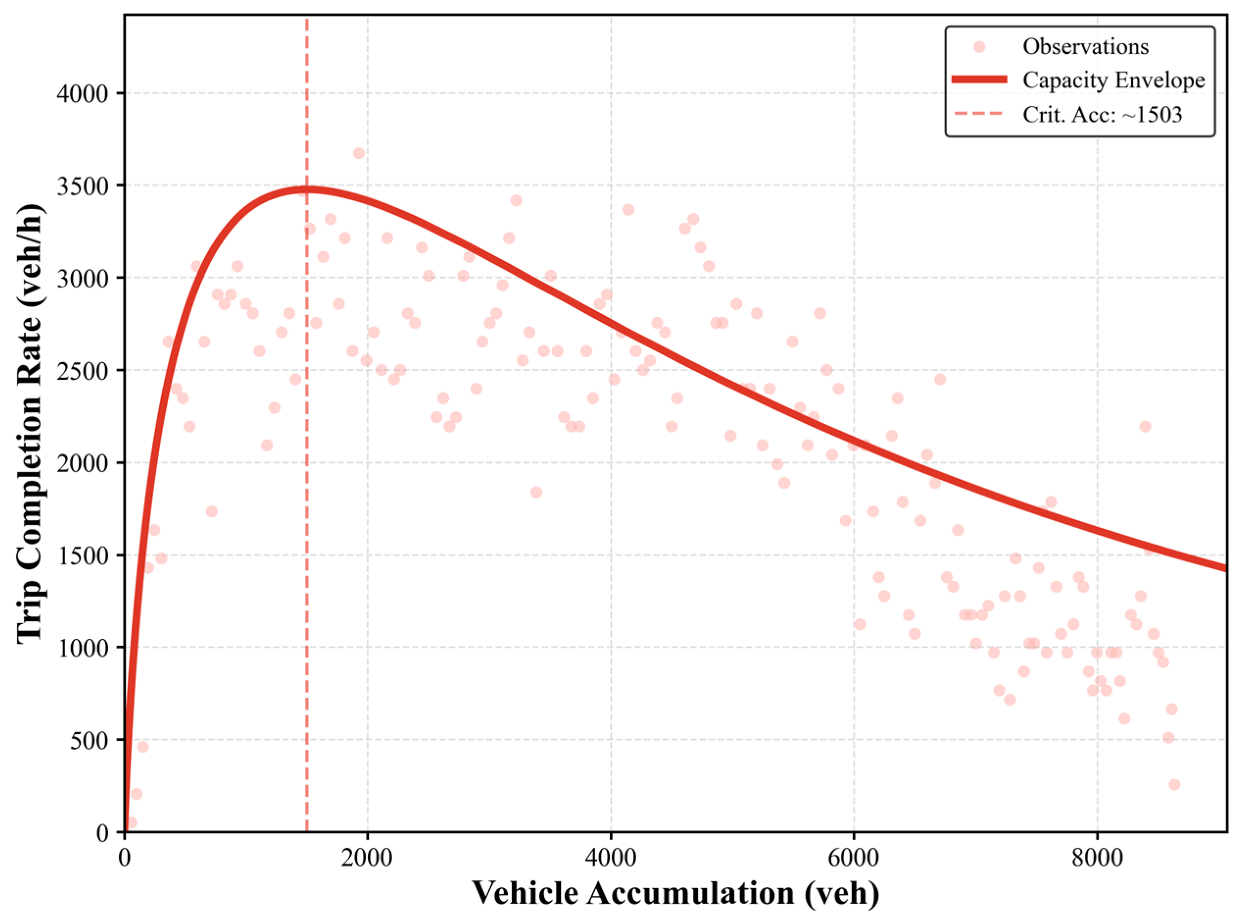
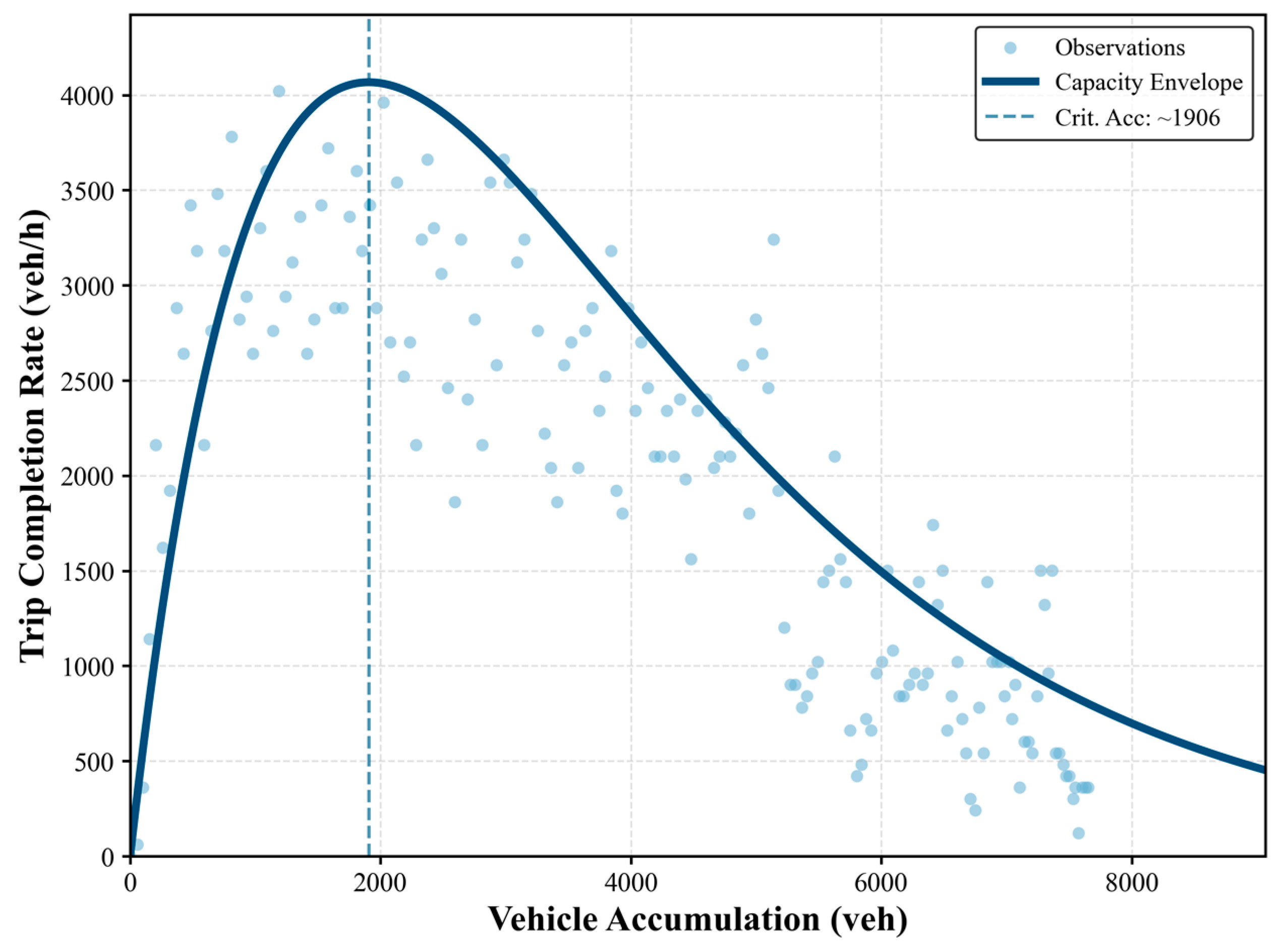
Under different weather conditions, the macroscopic relationship between vehicle accumulation and trip completion rate also shows different patterns. As shown in
Figure 7, under normal weather, the MFD presents a relatively regular parabolic shape, with the maximum trip completion rate of approximately 4070 veh/h occurring at a critical accumulation of 1906 vehicles. Under heavy rainfall, the shape of the MFD changes (
Figure 8). The MFD becomes flatter, exhibits a lower peak and has a generally downward-shifted envelope, indicating a degradation of effective network capacity. The critical accumulation shifts to a lower value, decreasing to approximately 1503 vehicles, and the corresponding maximum trip completion rate reduces to approximately 3480–3500 veh/h. A further comparison shows that heavy rainfall leads to an approximate 15–16% reduction in peak trip completion rate, while the critical accumulation decreases by about 21%, reflecting reduced discharge efficiency and delayed network saturation under rainfall disturbance. These results indicate that rainfall weakens the effective capacity of the network, forcing the system to break down and reach saturation at a lower vehicle accumulation level with a significantly lower maximum throughput, which increases the network’s vulnerability to severe congestion.
The above analysis indicates that heavy rainfall influences the urban traffic system through a set of interrelated changes. Under heavy rainfall, congestion tends to persist for a longer duration, and traffic speed recovers more slowly after peak periods, while overall traffic flow and effective network capacity are both reduced under rainfall conditions. These changes are further reflected in the macroscopic traffic dynamics, where the MFD under rainfall exhibits a lower critical accumulation and a flatter post-peak decline, indicating that once congestion emerges, the network experiences a more pronounced performance degradation. Rather than acting as a localized disruption, heavy rainfall reshapes the overall operating regime of the urban traffic system, highlighting the importance of explicitly considering weather-induced capacity degradation in perimeter control design.
4.2. Adaptive Distributed Perimeter Control Under Rainfall Conditions
To empirically validate the resilience enhancement capability of the proposed distributed coordinated perimeter control strategy, a rigorous simulation experiment is essential. Translating the theoretical control architecture into a functional simulation requires precise configuration of both the control parameters and the traffic environment. This section establishes the experimental foundation by specifying the key variables for the distributed controllers and replicating the realistic traffic dynamics under rainfall disturbances, thereby ensuring that the subsequent performance evaluation reflects the system’s actual response to extreme weather events.
4.2.1. Controller Design and Parameter Setting
Heavy rainfall usually leads to obvious degradation of road network capacity, and the recovery process of traffic conditions becomes much slower. Under such disturbance, the urban traffic network is more likely to deviate from its normal operating regime, and maintaining vehicle accumulation within a stable range becomes increasingly difficult. In such a situation, traditional PID control with fixed parameters often has difficulty keeping vehicle accumulation at a stable level. In order to deal with this problem, a two-layer distributed coordinated control framework is used in this study, which includes one main controller and several sub-controllers. The basic aim of this framework is to control vehicle accumulation inside the protected network around a critical value while limiting large fluctuations of boundary inflow when network capacity is reduced by rainfall.
The controller structure follows the distributed coordinated framework shown in
Figure 2. The main functions of different controllers are introduced below.
The main controller mainly works at a global level and is used to regulate the overall traffic state of the protected network. Its primary task is to keep the vehicle accumulation close to a target value related to the critical accumulation . This global-level control focuses on the overall balance between demand and supply and avoids being affected by short-term local disturbances. At each control interval , the main controller measures the current accumulation and then calculates the total perimeter control rate according to the error . This control rate is used as a coordination signal to adjust aggregate boundary inflow so that excessive demand will not enter the protected network when capacity is reduced under rainfall conditions.
The main controller then allocates to each boundary gate according to the priority coefficient of the gate, and the corresponding target entrance flow rate can be expressed as .
Considering that the influence of rainfall is not uniform at different entrances, local sub-controllers are further introduced to adjust the inflow at each boundary gate. For a given entrance , the sub-controller receives the target inflow from the main controller and then compares it with the measured local inflow . The difference between them is reduced by tuning the local perimeter control rate . To make the controller more suitable for heavy rainfall conditions, local water depth is added to the sub-controller as a correction variable, and the PID gains are modified during operation. With this setting, the controller can respond to uneven water accumulation at different entrances, instead of using fixed parameters for all locations.
With this two-layer structure, the traffic inflow in the protected network can be adjusted according to the overall traffic condition, and at the same time, the local response to rainfall disturbance is also considered. The upper layer mainly focuses on congestion suppression at the regional level, while the lower layer reacts to local disturbances at each entrance. As a result, the interaction between the main controller and sub-controllers helps prevent local disruptions from expanding into whole network congestion, allowing the urban traffic system to maintain a more stable operation during heavy rainfall events.
4.2.2. Simulation Setup and Implementation
A microscopic traffic simulation environment is built based on SUMO to test the proposed control strategy. The distributed control framework is implemented in Python 3.13 and connected with the simulator through the Traffic Control Interface (TraCI), which allows for data exchange between the controller and the simulation process. This simulation setup makes it possible to represent the closed-loop interaction among traffic demand, network operation and control action over time. To ensure simulation accuracy, the simulation time step is set to 1 s, and the total simulation period is 10,000 s. During the simulation process, the controller receives information such as vehicle accumulation and entrance flow in each control cycle, and then the updated control decision is sent back to the simulator for the next step of operation.
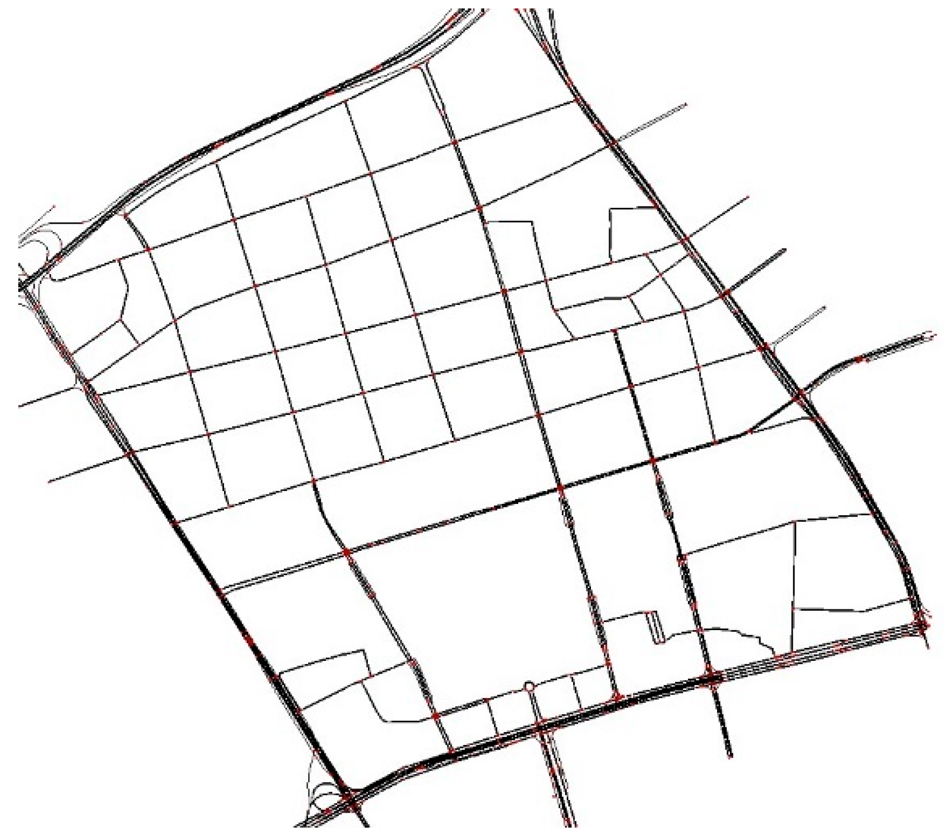
The empirical case study focuses on a core urban section in Jianghan District, Wuhan, due to its high network densities and complex entry topology. We downloaded the road network from OpenStreetMap (OSM) and performed rigorous topological cleaning. Since minor residential streets contribute little to the macroscopic perimeter flow, we applied hierarchical filtering to retain only the arterial and secondary roads, resulting in the simplified topology shown in
Figure 9.
Traffic demand was constructed from Wuhan taxi GPS trajectory data collected on 27 June 2023 (normal weather) and 29 June 2023 (heavy rainfall). After map-matching and trajectory segmentation, we calibrated the origin–destination (OD) matrices using an adaptive fine-tuning algorithm to align simulated flows with observed counts. Prior to map matching, abnormal records with unrealistic speeds or discontinuous jumps were removed to reduce positioning noise. The matching was performed using a Hidden Markov Model (HMM)-based trajectory–network alignment method that projects discrete GPS points onto road segments by jointly considering spatial proximity and network topology consistency. To mitigate GPS drift in dense urban environments, temporal continuity constraints were imposed to ensure trajectory consistency. The resulting origin–destination (OD) matrices were then calibrated against observed traffic counts at key locations. To eliminate the interference of demand fluctuations, the independent impact of rainfall on the supply side was focused on; the total OD demand in both weather scenarios was set to be consistent. Although field data indicate reduced travel volume and lower speeds during rainfall, a high-demand profile was retained in simulation to examine network responses under sustained loading conditions.
To model the supply-side disruptions caused by rainfall, we employed a global parameter reduction method and calibrated the parameters using real-world data from 29 June. Specifically, a uniform reduction coefficient was applied to all road segments and intersections in the network, reducing free-flow speed by approximately 20% and saturation flow by approximately 30% to simulate the deterioration of road traffic capacity under heavy rainfall conditions. In addition, several historically flood-prone locations were identified, and larger parameter reductions were applied at these locations (such as a 50% reduction in free-flow speed or temporary closure of road sections) to reproduce localized traffic bottlenecks caused by flooding.
The proposed controller interacts with the simulation platform in real time via the TraCI. To guarantee operational consistency and computational stability, all experiments set the same control cycle, signal timing, and parameter settings. Operationally, the main controller updates every 60 s to coordinate the global vehicle accumulation; the sub-controller adjusts the local gates every 5 s based on the flow feedback from each entrance. The signal cycle at the boundary intersections is fixed at 90 s, while the internal intersections use induction control, with the green light time dynamically adjusted between 6 and 45 s to achieve flexible allocation of road rights between the main road and the branch roads. The gate control rate at boundary entrances is constrained to the range [0.1,0,9].
The initial parameters of the PID controller are determined through offline calibration, with gains set as
,
, and
, and are adaptively adjusted during operation by the fuzzy logic module. The fuzzy controller takes error (
), its change rate (
), and the proxy variable for water depth (
) as inputs and outputs gain correction terms
,
, and
. The rule base of the controller contains 27 fuzzy rules (3 × 3 × 3), with membership functions in a symmetrical triangular form. Fuzzification and defuzzification are respectively based on the maximum membership principle and the weighted average method. This configuration achieves a good balance between computational efficiency and robust adaptability under rainfall disturbances. Simulation parameter settings are shown in
Table 1.
4.2.3. Results and Comparative Analysis
Based on the above simulation settings, this section evaluates the performance of different perimeter control strategies under a traffic congestion scenario induced by heavy rainfall. By applying different regulation strategies under the same rainfall disturbance, the evolution of urban traffic network operation is examined, with particular attention to congestion formation, accumulation dynamics, and recovery behavior at the network level. To verify the effectiveness of the proposed distributed coordinated fuzzy adaptive PID (DC-PID) perimeter control framework, the following three benchmark scenarios are set for comparison:
- (i)
No Control (NC): The boundary inflow is not restricted, and all intersections adopt a fixed timing signal control scheme;
- (ii)
Fixed PID Control (F-PID): A traditional feedback control scheme is used, with the controller gain being a constant; and
- (iii)
Adaptive PID Control PID (A-PID): The controller parameters are dynamically adjusted according to the real-time vehicle accumulation in the protected network.
All scenarios are simulated under the same conditions to ensure the comparability of the results.
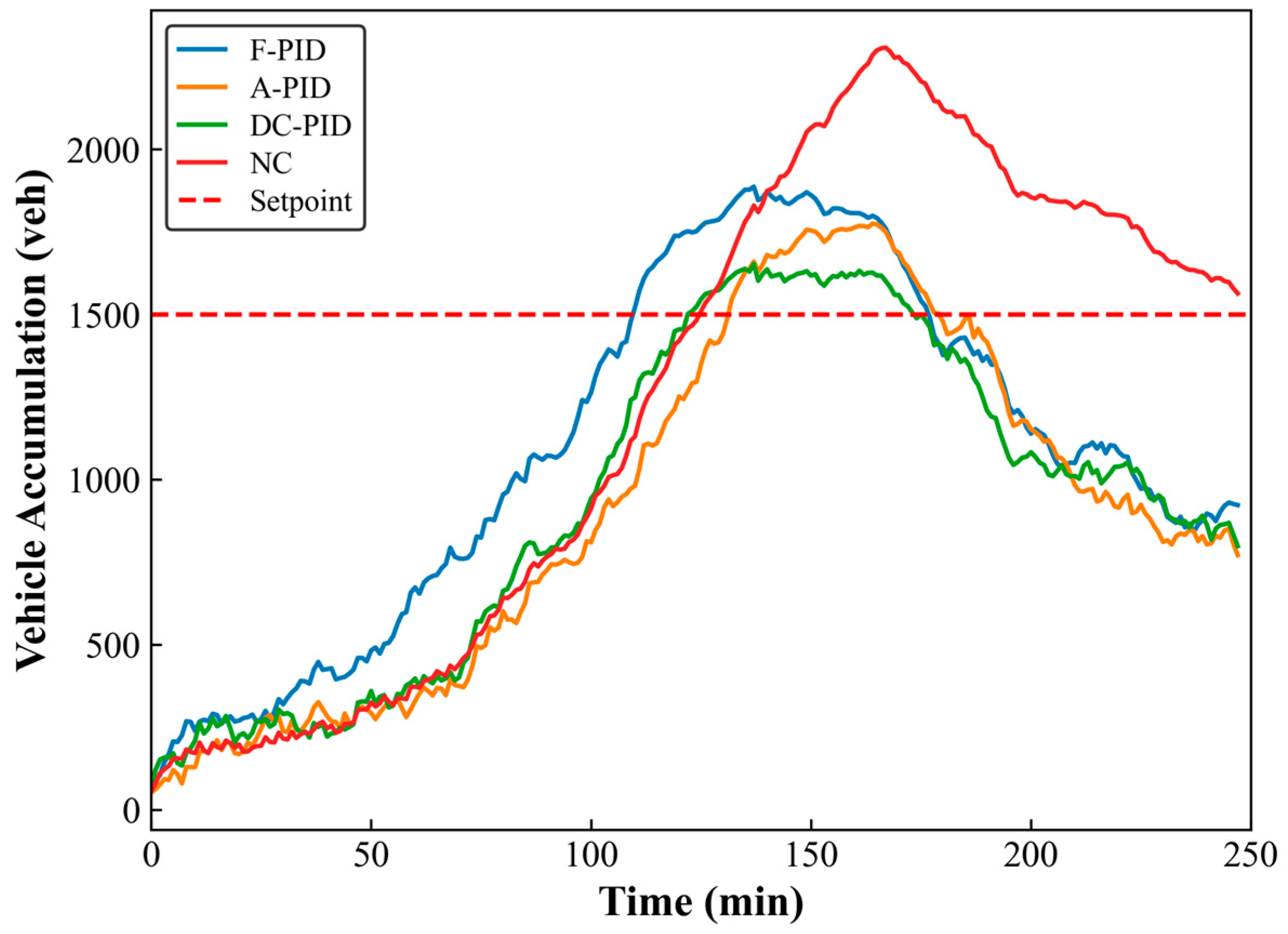
Figure 10 illustrates the temporal evolution of vehicle accumulation within the protected network under the four control strategies. In the initial stage, from 0 to 50 min, all strategies present similar accumulation levels because the traffic demand is relatively stable during this period. After the rainfall starts to influence the network capacity, the differences between strategies become clearer. In the NC case, due to the absence of boundary inflow constraints, vehicle accumulation keeps increasing and reaches a peak value of about 2308 vehicles during 160–180 min, and congestion lasts for a long time without effective recovery. For F-PID control, the increase in accumulation is partly limited, but a severe overshoot is observed, peaking at nearly 1900 vehicles, and the recovery speed is relatively slow. The A-PID strategy partially restricts the accumulation growth compared to F-PID, but it still exhibits noticeable oscillations and a large overshoot (peaking around 1800 vehicles) during peak rainfall. This instability arises because the single-layer mechanism relies on aggregated network error and ignores the spatial heterogeneity of water depth. Consequently, it suffers from a lagged response, reacting only after local capacity degradation at flooded links has propagated to the global scale. In comparison, distributed local feedback enables earlier corrective actions, leading to improved stability. The DC-PID strategy effectively suppresses the rapid accumulation growth, limiting the peak to around 1600 vehicles, and brings the accumulation closer to the target level within approximately 115 min. Because it proactively responds to local bottlenecks before they propagate, the DC-PID successfully stabilizes the network near the critical setpoint, showing very limited overshoot and small subsequent fluctuations, which helps maintain network stability and avoid secondary congestion caused by over-adjustment.
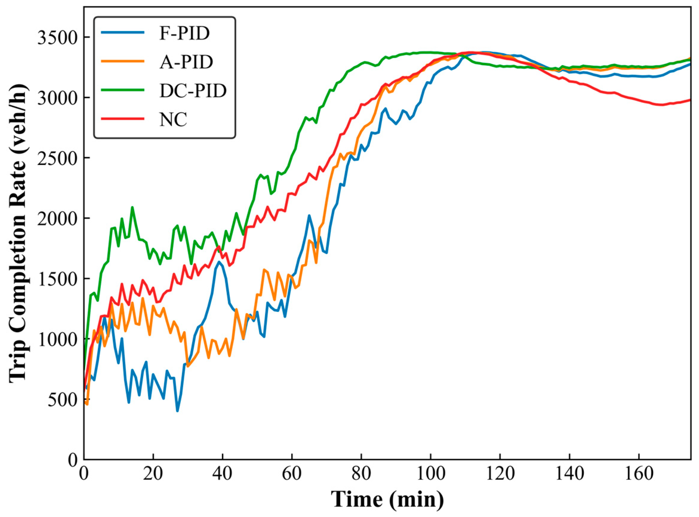
Figure 11 presents the variation of trip completion rate under different control strategies. In the NC scenario, due to the absence of inflow restrictions, the network remains oversaturated during rainfall, resulting in persistently low discharge efficiency and a significant decrease in trip completion rate. Compared with the NC case, both F-PID and A-PID improve the overall stability of the system to some extent in the later stages, but suffer from distinct performance degradation during the initial phase of the rainfall disturbance (0–60 min). Specifically, the F-PID strategy experiences a severe collapse, with the trip completion rate plunging to below 1000 veh/h, while the A-PID strategy exhibits sensitive oscillations and noticeable throughput reduction. The degradation of F-PID mainly stems from response delay, whereas A-PID is prone to oscillatory adjustments due to its single-layer structure. This performance degradation occurs because A-PID treats the network as a homogeneous reservoir, without accounting for the spatial heterogeneity of water depth, thereby failing to suppress local queue spillbacks before they propagate to the network level. In contrast, the DC-PID strategy demonstrates a consistent upward trend, characterized by more stable growth during the disturbance phase, reaching the maximum network trip completion rate (approximately 3300–3400 veh/h) much earlier than other strategies, and maintaining a faster recovery rate thereafter. This resilient performance is attributed to the distributed coordinated architecture: sub-controllers curb the propagation of local congestion based on real-time water depth, while the main controller stabilizes the regional accumulation near the critical density. As a result, the network can maintain a near-maximum outflow rate even when capacity is reduced by rainfall, which helps to ensure the robustness of traffic operation efficiency.
The results in
Table 2, together with the temporal profiles in
Figure 10 and
Figure 11, indicate that the DC-PID strategy achieves the most effective traffic regulation among the evaluated approaches. DC-PID yields the smallest peak accumulation, reaching 1653 vehicles compared with 1887 under F-PID, 1775 under A-PID and 2308 in the no-control case. This significant reduction of approximately 28.4% compared to the no-control scenario proves its superior capability in preventing severe network saturation. The corresponding
of 135 shows that this peak occurs earlier than in the other strategies, after which the accumulation remains close to the target threshold
, illustrating the controller’s capacity to stabilize the protected region and prevent the late-stage surges observed in the no-control scenario. For trip completion, DC-PID records 38.5 trips at 50 min and 52.7 trips at 75 min, which are higher than those observed under the other strategies at the same time points. In addition, the average network speed under DC-PID reaches 26.73 km/h. This high performance arises because DC-PID explicitly accounts for spatially heterogeneous water depth, effectively preventing local capacity drops from dragging down the average network velocity and enabling differentiated local responses that A-PID cannot provide. Compared with the no-control case, this corresponds to an increase of about 35.28%, and it is also approximately 13.46% and 21.83% higher than the speeds obtained under F-PID and A-PID, respectively.
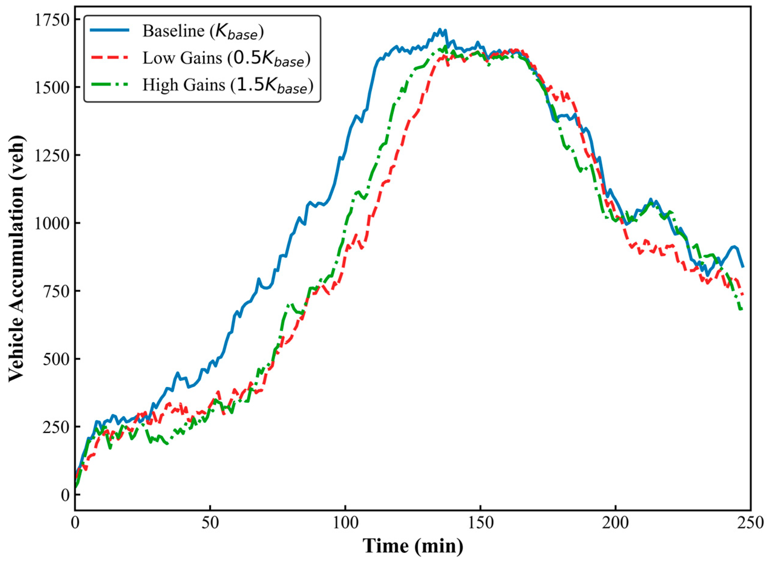
To further examine whether the observed performance depends heavily on specific parameter tuning, an additional sensitivity analysis with respect to the initial PID gains was conducted. Unlike traditional fixed-gain controllers that rely heavily on precise initialization of (
), the DC-PID framework incorporates a hierarchical adaptive mechanism. To assess its robustness, three gain configurations were examined, including the baseline gains, reduced gains (0.5
), and increased gains (1.5
). As illustrated in
Figure 12, although different initial gains influence the transient convergence rate, all vehicle accumulation trajectories converge toward a similar equilibrium region without instability or oscillatory amplification. This indicates that the adaptive tuning mechanism reduces sensitivity to initial parameter selection. In addition, since the fuzzy rule base governs qualitative adjustment tendencies rather than fixed numerical outputs, moderate perturbations in rule parameters do not alter system stability. Together, these results demonstrate that the proposed distributed control framework maintains robust performance under reasonable variations in initial PID gains and fuzzy rule configurations.
The combined evidence from the temporal trajectories and quantitative benchmarks demonstrates that the DC-PID framework does not merely achieve numerical performance improvements, but also leads to more effective regulation of urban traffic network operation under heavy rainfall disturbances. By coordinating the global vehicle accumulation target with local gate constraints, vehicle accumulation can be maintained closer to the critical level, which helps prevent the network from falling into severe congestion and allows traffic conditions to recover more rapidly once congestion occurs. Compared with the uncontrolled case, the strategy not only limits peak vehicle accumulation but also achieves an overall efficiency improvement of about 35.28%. Rather than validating the control strategy only in terms of efficiency gains, these results suggest that distributed coordinated perimeter control improves the ability of urban traffic systems to cope with non-periodic disturbances such as heavy rainfall by stabilizing network operation and accelerating congestion dissipation.
5. Discussion
Under heavy rainfall conditions, this paper discusses the traffic operation behavior of urban traffic systems and the performance of MFD-based perimeter control. Based on the analysis of real data, it can be observed that rainfall reduces road network capacity and also slows the congestion recovery process. This indicates that rainfall affects both the efficiency and the recovery dynamics of urban traffic networks. As a result, the network tends to enter congestion earlier, even when the cumulative vehicle number is not very high, suggesting a downward shift in the stability of the urban traffic system under external disturbance. The simulation results further indicate that the distributed cooperative adaptive control scheme generally performs better than the baseline strategies, including no control, fixed-gain PID, and adaptive PID.
From the perspective of the traffic control mechanism, the fuzzy adaptive PID controller helps keep the regional vehicle accumulation close to the critical threshold of the MFD. Under rainfall disturbance, this helps maintain the urban traffic network within a relatively stable operating range, thereby allowing the trip completion rate to remain at a higher level. The core advantage of this method lies in the “global-local” collaboration. The main controller adjusts the total inflow based on aggregated traffic conditions so that the overall operating range of the protected network can be stabilized when capacity is reduced by rainfall. At the same time, the sub-controllers incorporate local water accumulation information into the regulation process, enabling boundary inflows to be adjusted in accordance with uneven capacity degradation at different entrances. This distributed capability is essential because rainfall disturbances possess inherent spatial heterogeneity, causing localized rather than uniform capacity reductions. Unlike a single adaptive controller that often reacts with a lag to local bottlenecks due to its reliance on aggregated states, the proposed two-layer architecture decouples global coordination from local disturbance mitigation. With this design, the network can maintain a controllable operating condition during sudden capacity decline, and the recovery process after rainfall disturbance becomes smoother and faster.
In existing literature, many previous studies have shown that perimeter control is effective for managing periodic congestion, from both centralized and distributed control perspectives. Some studies also apply adaptive optimization methods to deal with traffic demand fluctuations. However, most of these works mainly focus on demand regulation under normal operating conditions, and the modeling and control coupling for external dynamic disturbances, such as rainfall, is still limited. By introducing rainfall-induced capacity reduction into the perimeter control framework, this paper demonstrates that the proposed control strategy is still effective when congestion is caused by non-periodic external shocks instead of regular demand cycles. The results further indicate that boundary inflow regulation is not only useful for efficiency improvement under normal conditions, but also helpful for maintaining stable network operation and speeding up the recovery process during extreme weather events.
It should be noted that the rainfall modeling in this paper adopts a unified free-flow velocity and intersection capacity attenuation coefficient, which may underestimate or overestimate the influence of spatially heterogeneous water accumulation across different regions. This simplification limits the ability of the model to capture fine-grained differences in disturbance impact within the network. Meanwhile, the case study is conducted on a single urban district in Wuhan, and its applicability to other cities and network structures still requires further verification. Future work can expand disturbance modeling for more extreme weather conditions, such as heavy snow or dense fog, and attempt to optimize the controller structure through reinforcement learning or neural adaptive methods. At the same time, it can be advanced to a multi-region network at the metropolitan level to enhance scalability.
Despite these current limitations, the proposed two-layer distributed framework inherently demonstrates strong scalability and adaptability for large-scale urban networks. Compared with centralized approaches, where computational complexity typically increases rapidly with network size, the distributed and modular architecture allows the framework to be extended to multi-region networks by integrating additional local controllers without reconfiguring the overall system structure. The separation between global regulation and local execution further reduces the computational burden during network expansion, as the main controller only monitors aggregated macroscopic traffic states, while boundary regulation is processed in parallel by regional sub-controllers.
In addition, the controller is built upon generic MFD theory and an adaptive PID mechanism, enabling automatic parameter adjustment based on real-time feedback such as water depth and accumulation error. This design allows the framework to remain robust under varying network topologies and rainfall intensities without extensive site-specific recalibration. Since the MFD reflects common macroscopic traffic characteristics observed in many metropolitan areas, the methodology can be transferred to other cities through recalibration of local MFD parameters and disturbance-related capacity reduction coefficients, without modifying the core control logic.
Therefore, the main insight of this paper is that the design of perimeter control strategies should not be limited to periodic congestion management but should also account for non-periodic disturbances such as heavy rainfall in both control objectives and feedback information. By integrating disturbance-aware feedback and coordinated boundary regulation, urban road networks can better withstand sudden capacity degradation and recover more efficiently from disrupted traffic conditions. The findings indicate that fuzzy adaptive perimeter control based on distributed collaboration can help suppress non-periodic congestion and improve the robustness of traffic operation under increasing climate-related uncertainty.
6. Conclusions
Heavy rainfall imposes time-varying external disturbances on urban transportation networks, leading to decreased operational efficiency, severe recovery hysteresis, and non-periodic congestion. To regulate urban traffic network operation under such disturbance scenarios, we construct a distributed cooperative adaptive perimeter control framework, using the MFD to characterize network operating states and control objectives. The framework employs a two-layer controller system. The main controller constrains the global congestion level near the critical point to prevent prolonged oversaturation. Meanwhile, the sub-controllers adjust control rates based on local water accumulation. This proactive localized regulation effectively dismantles the bottlenecks that typically drive the hysteresis loop, thereby preventing disturbance accumulation and reducing recovery delays.
A case study based on Jianghan District in Wuhan is carried out to examine the performance of the proposed framework. Both real traffic data and microscopic simulation are used in the evaluation. From the results, it can be observed that vehicle accumulation is kept close to the critical setpoint for most of the time, and the probability of entering an oversaturated state is reduced during the rainfall period. Compared with three control cases, the proposed control strategy shows shorter congestion duration and faster post-disturbance recovery, indicating that the proposed framework effectively mitigates rainfall-induced recovery hysteresis.
This study extends MFD-based perimeter control from conventional periodic congestion scenarios to non-periodic congestion triggered by sudden external disturbances, such as heavy rainfall. The distributed and modular design of the proposed framework also provides strong scalability and adaptability, allowing it to be extended to larger multi-region urban networks and applied to different cities or disturbance scenarios through appropriate parameter calibration. It should be noted that the effectiveness of the method is still related to disturbance description, parameter setting, and the characteristics of different regions. Therefore, further tests are needed under other urban networks and rainfall conditions. Nevertheless, the existing results suggest that adaptive perimeter control can support cities in better coping with rainfall-induced traffic congestion and maintaining more stable network operation under adverse weather conditions, providing a practical reference for urban traffic management under sudden rainfall disturbances.