


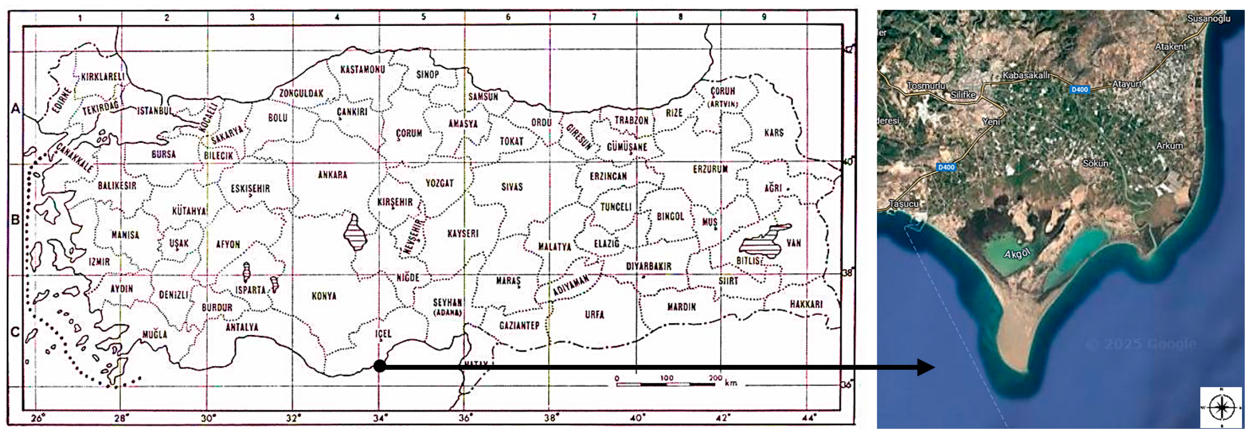
Vegetation Analysis of Wetland Ecosystems in Southern Turkey Using the Fuzzy Means Method


Simple Summary
Abstract
1. Introduction
2. Materials and Methods
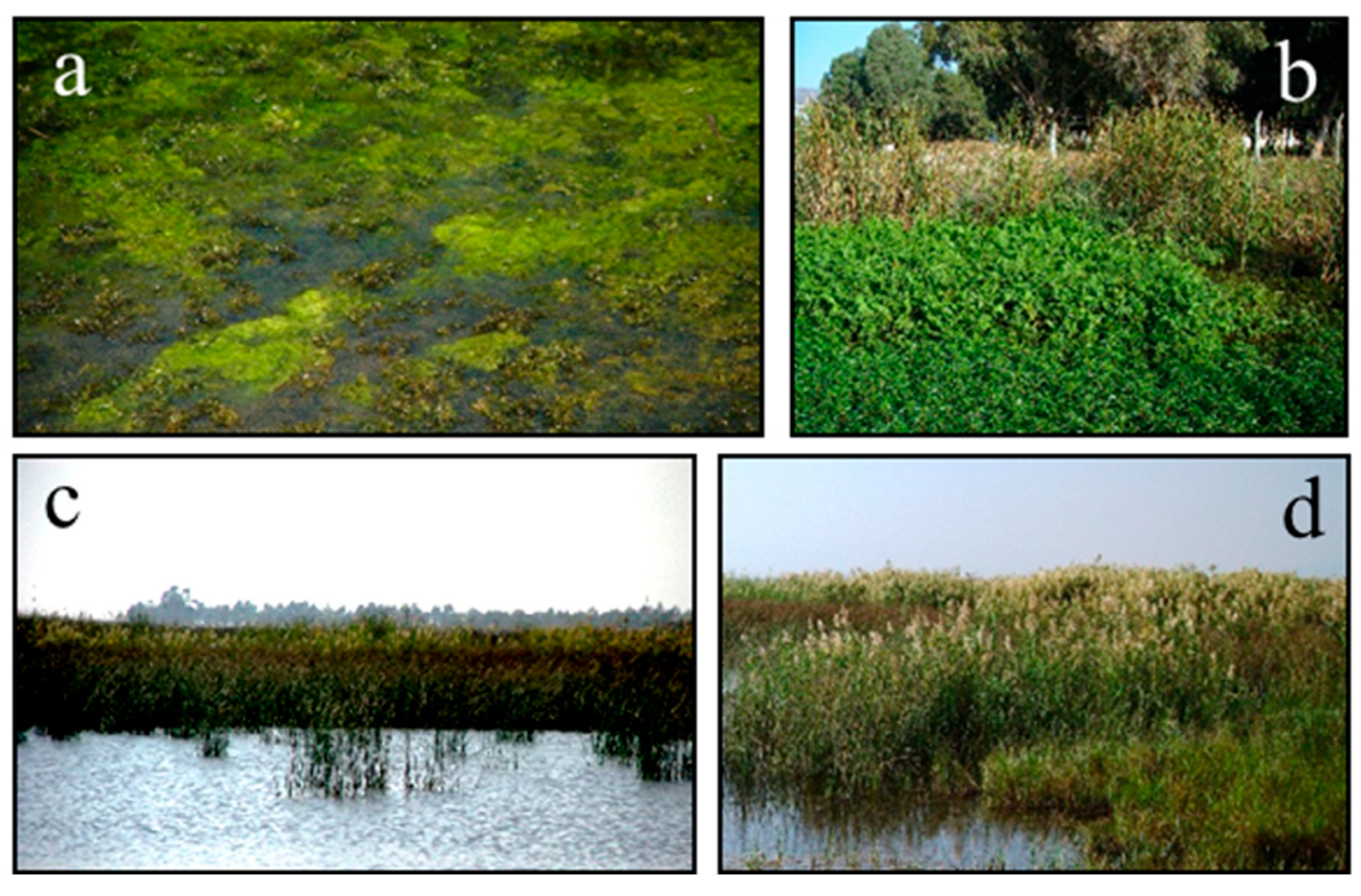
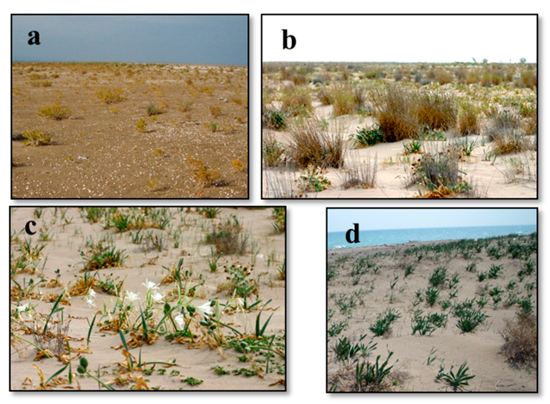
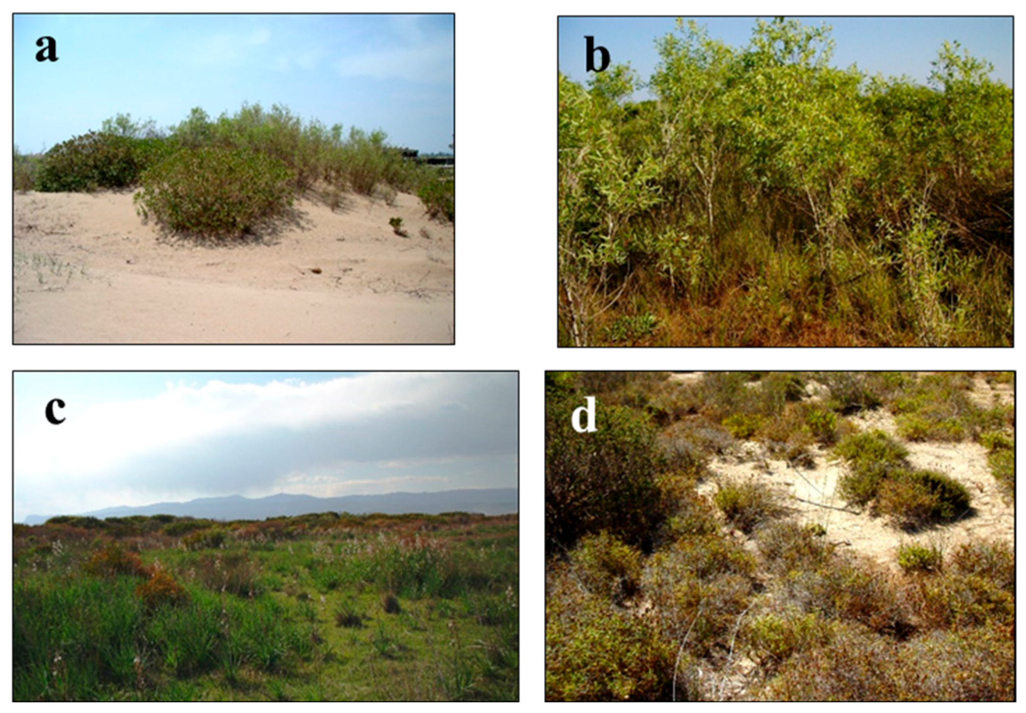
3. Results and Discussion
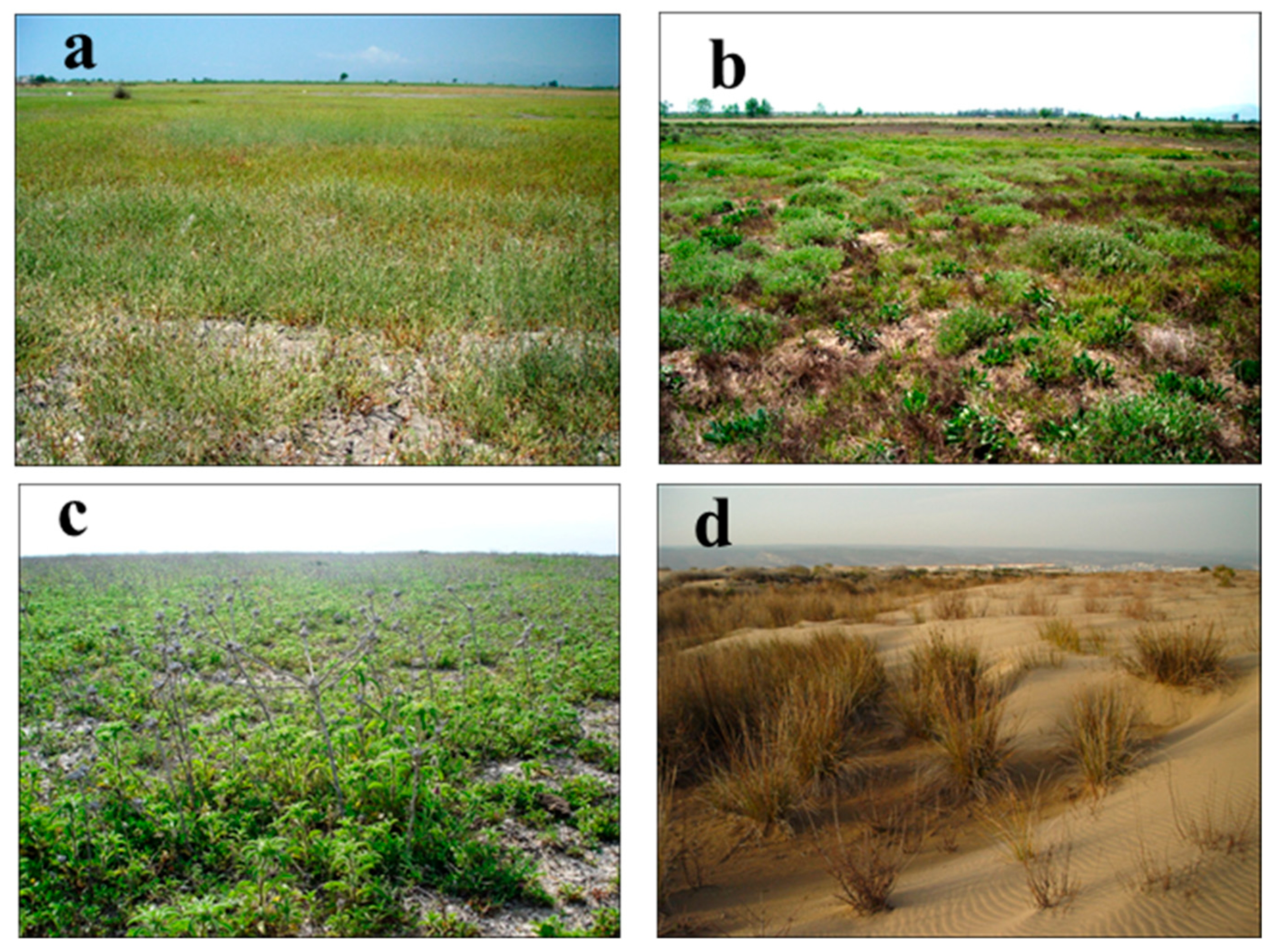
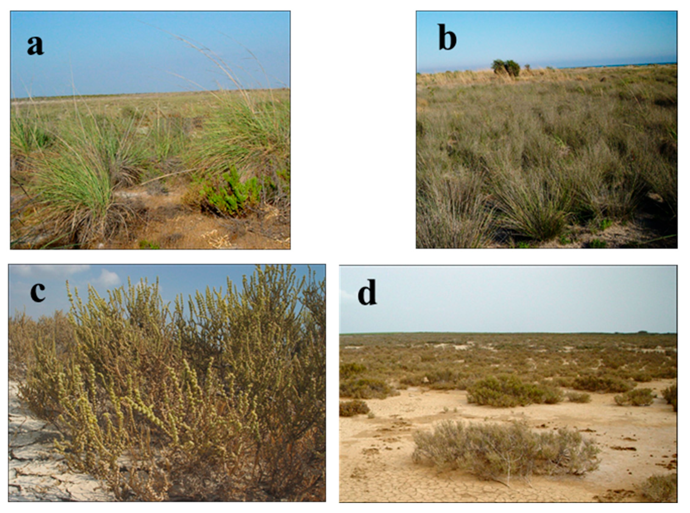
3.1. Aquatic Vegetation
3.2. Sand Dunes Vegetation
3.3. Halophytic Vegetation
4. Conclusions
Funding
Institutional Review Board Statement
Informed Consent Statement
Data Availability Statement
Acknowledgments
Conflicts of Interest
Appendix A

| Habitats | Classes | Ordo | Alliance | Association | |
|---|---|---|---|---|---|
| Aquatic Vegetation | The vegetation in the channel | Potametea Klika in Klika & Novák 1941 | Utricularietalia Den Hartog & Segal 1964 | Ceratophyllion demersi Den Hartog & Segal ex Passarge 1996 | Potamogetono pectinati-Ceratophylletum demersi (Hild & Rehnelt 1965) Passarge 1995 |
| Phragmito-Magnocaricetea Klika in Klika & Novák 1941 | Nasturtio-Glycerietalia Piggn. 1954 | Glycerio-Sparganion Br. Bl. Et Sissingh in Boer 1942 | Ludwigio stoloniferae-Nasturtietum officinalis ass. nov. | ||
| The vegetation in the lake | Phragmito-Magnocaricetea Klika in Klika & Novák 1941 | Phragmitetalia Koch 1926 | Phragmition communis Schmale 1939 | Ruppio cirrhosae-Schoenoplectetum littoralis ass. nov. | |
| Vegetation of the river and lake edges | Phragmito-Magnocaricetea Klika in Klika & Novák 1941 | Phragmitetalia Koch 1926 | Phragmition communis Schmale 1939 | Bolboschoeno maritimi var. cymos-Phragmitetum australis Borhidi &Balogh 1970 | |
| Sand dune vegetation | Moving coastal sand dune vegetation | Ammophiletea Br.-Bl. & Tüxen ex Westhoff, Dijk, & Passchier 1946 | Euphorbio-Ammophiletalia arundinaceae Br.-Bl. (1931) 1933 em. J.M. et J. Gehu 1988 | Euphorbio-Ammophilion arundinaceae Br.-Bl. (1931) 1933 em. J.M. et J. Gehu 1988 | Cakilo maritimae-Zygophylletum albi Çakan, Düzenli, & Karaömerlioğlu 2003 |
| Cypero mucronati-Agropyretum juncei Kühnholtz ex Br.-Bl. 1933 | |||||
| Eryngio maritimi-Pancratietum maritimi Çakan, Düzenli, & Karaömerlioğlu 2003 | |||||
| Ambrosio maritimae-Pancratietum maritimi ass. nov. | |||||
| Fixed or semi-shifting sand dune vegetation | Ammophiletea Br.-Bl. & Tüxen ex Westhoff, Dijk, & Passchier 1946 | Euphorbio-Ammophiletalia arundinaceae Br.-Bl. (1931) 1933 em. J.M. et J. Gehu 1988 | Euphorbio-Ammophilion arundinaceae Br.-Bl. (1931) 1933 em. J.M. et J. Gehu 1988 | Cypero capitati-Trachomitetum veneti ssp. sarmatiense ass. nov. | |
| Echio angustifolii-Ononidetum natrix ssp. hispanicae ass. nov. | |||||
| Parapholido incurvae-Thymelaeetum hirsutae ass. nov. | |||||
| Dune scrub vegetation | Ammophiletea Br.-Bl. & Tüxen ex Westhoff, Dijk, & Passchier 1946 | Euphorbio-Ammophiletalia arundinaceae Br.-Bl. (1931) 1933 em. J.M. et J. Gehu 1988 | Euphorbio-Ammophilion arundinaceae Br.-Bl. (1931) 1933 em. J.M. et J. Gehu 1988 | Sorgho halepense var. halepense-Myrtetum communis ssp. communis ass. nov. | |
| Polygono equisetiformis-Viticetum agni-casti ass. nov. | |||||
| Ephedro campylopodae-Populetum euphraticae ass. nov. | |||||
| Damaged sand dune vegetation | Ammophiletea Br.-Bl. & Tüxen ex Westhoff, Dijk, & Passchier 1946 | Euphorbio-Ammophiletalia arundinaceae Br.-Bl. (1931) 1933 em. J.M. et J. Gehu 1988 | Euphorbio-Ammophilion arundinaceae Br.-Bl. (1931) 1933 em. J.M. et J. Gehu 1988 | Urgino maritimi-Asphodeletum aestivi ass. nov. | |
| Verbasco sinuati-Sarcopoterietum spinosi ass. nov. | |||||
| Halophytic vegetation | Halophytic vegetation of the swamp | Salicornietea fruticosae Br.-Bl. & Tüxen ex A. & O. Bolòs 1950 | Salicornietalia fruticosae Br.-Bl. 1933 | Salicornion fruticosae Br.-Bl. 1933 | Limonio angustifolii-Halimionetum portulacoides ass. nov. |
| Asterisco aquaticae-Plantaginetum coronopi ssp. commutati ass. nov. | |||||
| Juncetea maritimi Br.-Bl. in Br.-Bl., Roussine & Nègre 1952 | Juncetalia maritimi Br.-Bl. 1931 em. Julve 1992 ex 1993 | Juncion maritimi Br.-Bl. 1931 em. Julve 1992 ex 1993 | Limonio gmelinii-Aeluropetum littoralis (Bab. 1979) Gehu & Uslu 1989 | ||
| Halophytic vegetation of temporary ponds | Juncetea maritimi Br.-Bl. in Br.-Bl., Roussine & Nègre 1952 | Juncetalia maritimi Br.-Bl. 1931 em. Julve 1992 ex 1993 | Juncion maritimi Br.-Bl. 1931 em. Julve 1992 ex 1993 | Polypogono maritimi ssp. maritimi-Juncetum littoralis Çakan, Düzenli, & Karaömerlioğlu 2003 | |
| Phragmiti australis-Juncetum maritimi Vural, Duman, & al. 1995 | |||||
| Atriplici hastatae-Juncetum acuti Çakan, Düzenli, & Karaömerlioğlu 2003 | |||||
| Halophytic vegetation of temporary floodplain | Salicornietea fruticosae Br.-Bl. & Tüxen ex A. & O. Bolòs 1950 | Salicornietalia fruticosae Br.-Bl. 1933 | Halocnemion strobilacei Gehu & Costa 1984 | Tamaricetum smyrensis Seçmen & Leblebici 1996 | |
| Juncetea maritimi Br.-Bl. in Br.-Bl., Roussine & Nègre 1952 | Juncetalia maritimi Br.-Bl. 1931 em. Julve 1992 ex 1993 | Juncion maritimi Br.-Bl. 1931 em. Julve 1992 ex 1993 | Arthrocnemo fruticosii-Tamaricetum tetragynae ass. nov. | ||
| Salicornio fragilis-Tamaricetum tetrandrae ass. nov. | |||||
| Schoeno nigricantis-Saccharetum ravennae Çakan, Düzenli, & Karaömerlioğlu 2003 | |||||
| Molinio-Juncetea Br.-Bl. (1931) 1947 | Holoschoenetalia Br.-Bl. (1931) 1947 | Molinio-Holoschoenion Br.-Bl. (1931) 1947 | Eriantho-Schoenotum nigricantis (Pign. 1953) Gehu 1984 | ||
| Halophytic vegetation of terrestrial flatness | Salicornietea fruticosae Br.-Bl. & Tüxen ex A. & O. Bolòs 1950 | Salicornietalia fruticosae Br.-Bl. 1933 | Salicornion fruticosae Br.-Bl. 1933 | Salicornio europaeae-Arthrocnemetum fruticosum Çakan, Düzenli, & Karaömerlioğlu 2003 | |
| Halocnemion strobilacei Gehu & Costa 1984 | Arthrocnemo-Halocnemetum strobilaceii Oberd 1952 | ||||
References
- Akman, Y.; Düzenli, A.; Güney, K. Biyocoğrafya; Palme: Ankara, Türkiye, 2005; p. 449. [Google Scholar]
- Akman, Y. Türkiye Orman Vejetasyonu; Ankara University Press: Ankara, Türkiye, 1995; p. 450. [Google Scholar]
- Uslu, T. A Plant Ecological and Sociological Research on the Dune and Maquis Vegetation between Mersin and Silifke. Communications 1977, 21, 60. [Google Scholar]
- Gehu, J.M.; Uslu, T.; Costa, M. Aport a la Connaissance Phytosociologique du Littoral Sud de la Turquie Mediterraneenne. Colloq. Phytosociol. 1989, 19, 591–622. [Google Scholar]
- Gürkan, F.; Zorlu, F.; Kavruk, S.A.; Menengiç, M.; Yildirim, N.; Erdoğan, B.; Direk, Y.; Buluş, B.; Sarigül, B. Göksu Deltası Özel Çevre Koruma Bölgesi Yönetim Planı; TC. Çevre Bak; ÖÇKK Başkanlığı-DHKD: Ankara, Türkiye, 1999. [Google Scholar]
- Greuter, W.; Mcneill, J.; Barrie, F.R.; Burdet, H.-M.; Demoulin, V.; Filgueiras, T.S.; Nicolson, D.H.; Silva, P.C.; Skog, J.E.; Trehane, P.; et al. International Code of Botanical Nomenclature (St Louis Code); Regnum Vegetabile 138; Koeltz Scientific Books: Königstein, Gremany, 2000; ISBN 3-904144-22-7. [Google Scholar]
- Bekat, L.; Seçmen, Ö. The Phytoecological and Sociological Investigations on the Akdağ-Karaburun (İzmir). J. Fac. Sci. Ege Uni. 1984, 7, 103–110. [Google Scholar]
- Bekat, L.; Seçmen, Ö. Vegetation in der Umgebung Von Foça, Aliağa und Çandarlı. J. Fac. Sci. Ege Uni. 1988, 10, 5–26. [Google Scholar]
- Çakan, H.; Düzenli, A.; Karaömerlioğlu, D. Çukurova Deltası (Yumurtalık Lagünü, Akyatan, Ağyatan ve Tuz Gölü) Vejetasyonunun Araştırılması; TÜBİTAK: Ankara, Türkiye, 2003; TBAG-1793. [Google Scholar]
- Çetik, A.R. Sorgun (Manavgat), Kemer, Lara (Antalya) ve Kavaklı (Finike) Kumullarının Fitososyolojik ve Fitoekolojik Yönden İncelenmesi. Atatürk Üni. Fen-Ed. Fak. Fen Dergisi 1982, 1, 331–359. [Google Scholar]
- Gehu, J.M.; Uslu, T. Donněes Sur la Věgětation Littorale de la Turquie du Nord-Ouest. Phytocoenologia 1989, 17, 449–505. [Google Scholar] [CrossRef]
- Hamzaoğlu, E.; Aksoy, A. Sultansazlığı Bataklığı Halofitik Toplulukları Üzerine Fitososyolojik Bir Çalışma (İç Anadolu-Kayseri). Ekoloji Dergisi 2006, 15, 8–15. [Google Scholar]
- Kavak, S. Burnaz Kumullarının (Adana) Flora ve Vejetasyonu. Master’s Thesis, Çukurova Üniversitesi Fen Bilimleri Enstitüsü, Adana, Türkiye, 2006. [Google Scholar]
- Kilinç, M.; Karaer, F.; Özen, F. Karadeniz Bölgesinin Sahil Kesiminde Yayılış Gösteren Maki Vejetasyonu Üzerinde Floristik ve Fitososyolojik Bir Araştırma. In Proceedings of the XI. Ulusal Biyoloji Kongresi, Fırat Üniversitesi, Elazığ, Türkiye, 24–27 June 1992; pp. 213–232. [Google Scholar]
- Kilinç, M.; Karaer, F. The Vegetation of Sinop Peninsula. Turk. J. Bot. 1995, 19, 107–124. [Google Scholar]
- Küçüködük, M. Beyşehir Gölünün Flora ve Vejetasyonunun İncelenmesi. Ph.D. Thesis, Selçuk Üniversitesi, Fen Bilimleri Enstitüsü, Konya, Türkiye, 1987; p. 123. [Google Scholar]
- Öner, M.; Oflas, S.; Oğuz, G. İzmir Civarında Bulunan Turtes, Zeytineli Limanı, Oğlananası Gölü, Belevi Drenaj Kanalı, Belevi Gerisindeki Göl Mevkii, Pamucak ve Tusan Oteli Civarında Vejetasyon Gelişimi; Ege Üniversitesi Matbaası: İzmir, Türkiye, 1973; Volume 160, pp. 1–20. [Google Scholar]
- Öner, M.; Oflas, S.; Oğuz, G. İzmir Civarında Bulunan Karagöl, Çamaltı, Bayraklı, Kalabak, Eğri Limanı, Urla İçmelerinde Vejetasyon Gelişimi; Ege Üniversitesi Matbaası: İzmir, Türkiye, 1973; Volume 159, pp. 1–22. [Google Scholar]
- Özkanca, R. Orta Karadeniz Bölgesi Kıyı Kumullarının Vejetasyonu Üzerinde Fitososyolojik Bir Araştırma. Masters’s Thesis, Ondokuz Mayıs Üniversitesi, Fen Bilimleri Enstitüsü, İzmir, Türkiye, 1989. [Google Scholar]
- Özen, F.; Kilinç, M. Alaçam-Gerze ve Boyabat-Durağan Arasında Kalan Bölgenin Vejetasyonu. Turk. J. Bot. 1995, 19, 65–86. [Google Scholar]
- Seçmen, Ö. Gökçeada ve Bozcaada Adalarının Flora ve Vejetasyonu; TÜBİTAK: İzmir, Türkiye, 1977; TBAG-211. [Google Scholar]
- Seçmen, Ö.; Leblebici, E. Gökçeada ve Bozcaada Adalarının Flora ve Vejetasyonu. Bitki Der. 1978, 5, 195–367. [Google Scholar]
- Seçmen, Ö.; Leblebici, E. Türkiye’nin Bazı Bataklık ve Göllerinin Vejetasyonu; TÜBİTAK VII. Bilim Kong.: Aydın, Türkiye, 1980; pp. 665–673. [Google Scholar]
- Seçmen, Ö.; Leblebici, E. Ege Bölgesi-İç Anadolu Batısı ve Akdeniz Bölgesi’nin Batısında (B1, B2, B3, C1, C2, C3) Bulunan Göl ve Bataklıkların Flora ve Vejetasyonu; TÜBİTAK: İzmir, Türkiye, 1982; TBAG-407. [Google Scholar]
- Seçmen, Ö.; Leblebici, E. Aquatic Flora of Western Anatolia. Willdenowia 1984, 14, 165–178. [Google Scholar]
- Seçmen, Ö.; Leblebici, E. Trakya, Batı ve Orta Karadeniz, İç Anadolu ile Doğu Akdeniz Bölgesinde Bulunan (A1-5, B4-5, C4-5) Göl ve Bataklıkların Flora ve Vejetasyonu; TÜBİTAK: İzmir, Türkiye, 1987; TBAG-654. [Google Scholar]
- Seçmen, Ö.; Leblebici, E. Aquatic and Marshy Vegetation of Thrace. Tr. J. Bot. 1991, 15, 142–165. [Google Scholar]
- Seçmen, Ö.; Leblebici, E. Doğu Karadeniz, İç Anadolu Doğusu ve Güneydoğu Anadolu Bölgesi’nin Batısında (A6-9, B6, C6) Bulunan Göl ve Bataklıkların Flora ve Vejetasyonu; TÜBİTAK: İzmir, Türkiye, 1992; TBAG-892. [Google Scholar]
- Seçmen, Ö.; Leblebici, E. The Comparision of Lake Vegetations of Thrace. In Proceedings of the XII. Ulusal Biyoloji Kongresi, Edirne, Türkiye, 6 July–8 July 1994; pp. 109–112. [Google Scholar]
- Seçmen, Ö.; Leblebici, E. The Vegetation Cover of Marmara Region Wetlands. J. Bot. 1996, 20, 171–188. [Google Scholar] [CrossRef]
- Seçmen, Ö.; Gemici, Y.; Bekat, L.; Görk, G. İzmir Yöresi Frigana Vejetasyonunun Bitki Sosyolojisi Yönünden Araştırılması. Doğa Tr Bio. Der. 1986, 10, 197–205. [Google Scholar]
- Yurdakulol, E. Konya Ovasındaki Çorak Bataklıklar Vejetasyonunun Bitki Sosyolojisi Yönünden Araştırılması. Bitki 1974, 1, 257–277. [Google Scholar]
- Yurdakulol, E.; Öncel, I.; Demirörs, M.; Yildiz, A.; Keleş, Y. Ecological and Syntaxonomic Investigation of Salt Marshes Vegetation in the Vicinity of Burdur and Acigöl (Denizli-Turkey). Ecol. Medit. 1996, 22, 51–61. [Google Scholar] [CrossRef]
- Rivas-Martinez, S. Syntaxonomical Synopsis of The North America Natural Potential Vegetation Communities, I (Compendio sintaxonómico de la vegetación natural potencial de Norteamérica, I). Itinera Geobotánica 1997, 10, 5–148. [Google Scholar]
- Rivas-Martinez, S.; Sánchez-Mata, D.; Costa, M. North American Boreal and Western Temperate Forest Vegetation (Syntaxonomical Synopsis of The Potential Natural Plant Communities of North America, II). Itinera Geobotanica 1999, 12, 5–316. [Google Scholar]
- Rivas-Martinez, S.; Fernández-González, F.; Loidi, J.; Lousã, M.; Penas, A. Syntaxonomical Checklist of Vascular Plant Communities of Spain and Portugal to Association Level. Itinera Geobotanica 2001, 14, 5–341. [Google Scholar]
- Pafumi, E.; Angiolini, C.; Bacaro, G.; Fanfarillo, E.; Fiaschi, T.; Rocchini, D.; Sarmati, S.; Torresani, M.; Feilhauer, H.; Maccherini, S. Fuzzy Approaches Provide Improved Spatial Detection of Coastal Dune EU Habitats. Ecol. Inform. 2025, 86, 1–14. [Google Scholar] [CrossRef]
- Barve, S.; Webster, J.M.; Chandra, R. Reef-Insight: A Framework for Reef Habitat Mapping with Clustering Methods Using Remote Sensing. Information 2023, 2, 1–16. [Google Scholar] [CrossRef]
- Braun-Blanquet, J. Pflanzensoziologie: Grundzüge der Vegetationskunde, 2nd ed.; Springer: Vienna, Austria, 1951. [Google Scholar]
- Zadeh, L.A. Fuzzy sets. Inf. Control 1965, 8, 338–353. [Google Scholar] [CrossRef]
- Davis, P.H. Flora of Turkey and the East Aegean Islands; Edinburgh University Press: Edinburgh, UK, 1988; Volumes 1–10, C:1-10. [Google Scholar]
- Uygun, N.; Dinç, U.; Şekeroğlu, E.; Yeğingil, İ.; Uzun, G.; Kornoşor, S.; Düzenli, A.; Gültekin, E.; Şenol, S.; Biçici, M.; et al. Göksu Deltası’nın Biyolojik Zenginliğinin (Flora ve Fauna) Tespiti ile Ekolojik Peyzaj ve Optimal Arazi Kullanım Planlaması. Cilt I; T.C. Çevre Bakanlığı Özel Çevre Kurumu Başkanlığı: Adana, Türkiye, 1994; Proje no:09.G.92/03. [Google Scholar]
- Akman, Y. İklim ve Biyoiklim; Kariyer Matbaacılık Ltd. Şti.: Ankara, Türkiye, 1999; p. 350. [Google Scholar]
- Öztürk, M.; Pirdal, M.; Özdemir, F. Bitki Ekolojisi Uygulamalar; Ege Üniversitesi Matbaası: İzmir, Türkiye, 1997; p. 129. [Google Scholar]
- Google Earth. 2025. Available online: https://www.google.com.tr/maps/@36.3334061,33.8202931,43240m/data=!3m1!1e3?entry=ttu&g_ep=EgoyMDI1MDYwNC4wIKXMDSoASAFQAw%3D%3D (accessed on 9 March 2025).
- European Comission, 2003-2011. NATURA2000, Interpretation Manual Of European Union Habitats-Eur 25; Nature and Biodiversity Series, No. 126; European Comission: Brussels, Belgium, 2025. [Google Scholar]
- Yilmaz, K.T.; Çakan, H.; Düzenli, A.; Karaömerlioğlu, D. A Case Study on Baseline Data Inventory for Coastal Zone Management: Habitat Classification in the Göksu Delta SPA/Turkey. In Proceedings of the X. European Ecological Congress, Kuşadası, İzmir, Turkey, 8–13 November 2005; p. 269. [Google Scholar]
- Braun-Blanquet, J. Pflanzensoziologie; Springer: Berlin, Germany, 1964; p. 866. [Google Scholar]
- Parolly, G. Towards Common Standards in Phytosociological Papers Submitted to the Turkish Journal of Botany: A Letter from the Editor. Turk. J Bot. 2003, 27, 163–165. [Google Scholar]
- Soil Survey Staff. Soil Survey Manual; Handbook No. 18; USDA: Washington, DC, USA, 1951; p. 503.
- Richards, L.A. Diagnosis and Improvement of Saline Alkali Soils; Agriculture, Handbook 60: Washington, DC, USA, 1954; p. 154. [Google Scholar]
- Boşgelmez, A.; Boşgelmez, I.I.; Savaşçi, S.; Pasli, N. Ekoloji-II Toprak; Başkent Klişe Mat.: Ankara, Türkiye, 2001; p. 1054. [Google Scholar]
- Özbek, H.; Kaya, Z.; Gök, M.; Kaptan, H. Toprak Bilimi; Ç.Ü. Ziraat Fak. Ofset ve Teksir Atölyesi: Adana, Türkiye, 1995; Volume 135-16, p. 816. [Google Scholar]
- Kilinç, M. Bitki Sosyolojisi; Palme Yayincilik: Ankara, Türkiye, 2005; p. 284. [Google Scholar]
- Association Tela Botanica. Flore et végétation de la France, CATMINAT, Tela Botanica, Le réseau de la botanique francophone, Phytosociologie, Le réseau des Botanistes Francophones 2000. Available online: http://www.tela-botanica.org (accessed on 9 March 2025).
- Theurillat, J.P.; Willner, W.; Fernández-González, F.; Bültmann, H.; Čarni, A.; Gigante, D.; Mucina, L.; Weber, H. International Code of Phytosociological Nomenclature. 4th edition. Appl. Veg. Sci. 2021, 24, e12491. [Google Scholar] [CrossRef]


| Habitat Types | Association Name | Clusters | |||
|---|---|---|---|---|---|
| 1 | 2 | 3 | |||
| Halophytic | Swamp | Limonio gmelinii-Aeluropetum littoralis (Bab. 1979) Gehu & Uslu 1989 | 0.49 | 0.28 | 0.23 |
| Limonio angustifolii-Halimionetum portulacoides ass. nov. | 0.86 | 0.10 | 0.04 | ||
| Asterisco aquaticae-Plantaginetum coronopi ssp. commutati ass. nov. | 0.23 | 0.05 | 0.71 | ||
| Temporary ponds | Polypogono maritimi ssp. maritimi-Juncetum littoralis Çakan, Düzenli, & Karaömerlioğlu 2003 | 0.02 | 0.01 | 0.98 | |
| Phragmiti australis-Juncetum maritimi Vural, Duman, & al. 1995 | 0.07 | 0.90 | 0.02 | ||
| Atriplici hastatae-Juncetum acuti Çakan, Düzenli, & Karaömerlioğlu 2003 | 0.63 | 0.10 | 0.27 | ||
| Temporary flood plain | Tamaricetum smyrensis Seçmen & Leblebici 1996 | 0.80 | 0.14 | 0.06 | |
| Arthrocnemo fruticosii-Tamaricetum tetragynae ass. nov. | 0.92 | 0.05 | 0.03 | ||
| Salicornio fragilis-Tamaricetum tetrandrae ass. nov. | 0.84 | 0.08 | 0.07 | ||
| Schoeno nigricantis-Saccharetum ravennae Çakan, Düzenli, & Karaömerlioğlu 2003 | 0.01 | 0.00 | 0.99 | ||
| Eriantho-Schoenotum nigricantis (Pign. 1953) Gehu 1984 | 0.02 | 0.01 | 0.97 | ||
| Terrestrial flatness | Salicornio europaeae-Arthrocnemetum fruticosum Çakan, Düzenli, & Karaömerlioğlu 2003 | 0.74 | 0.13 | 0.13 | |
| Arthrocnemo-Halocnemetum strobilaceii Oberd 1952 | 0.93 | 0.05 | 0.03 | ||
| Aquatic | The river and lake edges | Bolboschoeno maritimi var. cymos-Phragmitetum australis Borhidi & Balogh 1970 | 0.11 | 0.85 | 0.04 |
| Sand Dune | Moving coastal sand dune | Cypero mucronati-Agropyretum juncei Kühnholtz ex Br.-Bl. 1933 | 0.03 | 0.01 | 0.96 |
| Cakilo maritimae-Zygophylletum albi Çakan, Düzenli, & Karaömerlioğlu 2003 | 0.22 | 0.07 | 0.72 | ||
| Eryngio maritimi-Pancratietum maritimi Çakan, Düzenli, & Karaömerlioğlu 2003 | 0.25 | 0.07 | 0.68 | ||
| Ambrosio maritimae-Pancratietum maritimi ass. nov. | 0.25 | 0.07 | 0.68 | ||
| Fixed or semi-shifting sand dune | Parapholido incurvae-Thymelaeetum hirsutae ass. nov. | 0.10 | 0.02 | 0.87 | |
| Cypero capitati-Trachomitetum veneti ssp. sarmatiense ass. nov. | 0.11 | 0.04 | 0.85 | ||
| Echio angustifolii-Ononidetum natrix ssp. hispanicae ass. nov. | 0.03 | 0.01 | 0.95 | ||
| Dune scrub | Sorgho halepense var. halepense-Myrtetum communis ssp. communis ass. nov. | 0.12 | 0.05 | 0.83 | |
| Polygono equisetiformis-Viticetum agni-casti ass. nov. | 0.28 | 0.07 | 0.66 | ||
| Ephedro campylopodae-Populetum euphraticae ass. nov. | 0.08 | 0.03 | 0.90 | ||
| Damaged sand dune | Urgino maritimi-Asphodeletum aestivi ass. nov. | 0.05 | 0.01 | 0.94 | |
| Verbasco sinuati-Sarcopoterietum spinosi ass. nov. | 0.07 | 0.02 | 0.92 | ||
| Aquatic Habitat Types | Association Name | Winter Clusters | Spring Clusters | Summer Clusters | Autumn Clusters | ||||||||
|---|---|---|---|---|---|---|---|---|---|---|---|---|---|
| 1 | 2 | 3 | 1 | 2 | 3 | 1 | 2 | 3 | 1 | 2 | 3 | ||
| In the channel | Ludwigio stoloniferae-Nasturtietum officinalis ass. nov. | 0.00 | 0.00 | 1.00 | 0.00 | 0.00 | 1.00 | 0.00 | 0.00 | 1.00 | 0.00 | 0.00 | 1.00 |
| 0.00 | 0.00 | 1.00 | 0.00 | 0.00 | 1.00 | 0.00 | 0.00 | 1.00 | 0.00 | 0.00 | 1.00 | ||
| Potamogetono pectinati-Ceratophylletum demersi (Hild & Rehnelt 1965) Passarge 1995 | 0.00 | 0.00 | 1.00 | 0.00 | 0.00 | 1.00 | 0.00 | 0.00 | 1.00 | 0.00 | 0.00 | 1.00 | |
| 0.00 | 0.00 | 1.00 | 0.00 | 0.00 | 1.00 | 0.00 | 0.00 | 1.00 | 0.00 | 0.00 | 1.00 | ||
| In the lake | Ruppio cirrhosae-Schoenoplectetum litoralis ass. nov. | 0.97 | 0.01 | 0.02 | 0.00 | 0.01 | 0.99 | 0.00 | 0.02 | 0.98 | 0.02 | 0.00 | 0.97 |
| 0.37 | 0.03 | 0.60 | 0.00 | 0.02 | 0.98 | 0.00 | 0.10 | 0.89 | 0.99 | 0.01 | 0.01 | ||
| The river and lake edges | Bolboschoeno maritimi var. cymos-Phragmitetum australis Borhidi & Balogh 1970 | 0.00 | 0.00 | 1.00 | 0.00 | 0.00 | 1.00 | 0.00 | 0.02 | 0.98 | 0.00 | 0.00 | 1.00 |
| 0.97 | 0.01 | 0.02 | 0.00 | 0.01 | 0.99 | 0.00 | 0.02 | 0.98 | 0.02 | 0.00 | 0.97 | ||
| Vegetation Types | Associations | Sample Area Number | Sample Area Size | Altitude | Sampling Time | GPS Coordinates | Sample Area Number | Sample Area Size | Altitude | Sampling Time | GPS Coordinates | |
|---|---|---|---|---|---|---|---|---|---|---|---|---|
| Aquatic Vegetation | The vegetation in the channel | Potamogetono pectinati-Ceratophylletum demersi (Hild & Rehnelt 1965) Passarge 1995 | 361 | 0 m | 24.07.2004 | N: 36°19′931″ | 363 | 0 m | 24.07.2004 | N: 36°20′292″ | ||
| 25 m2 | E: 33°56′224″ | 50 m2 | E: 34°56′159″ | |||||||||
| 347 | 0 m | 23.07.2004 | N: 36°20′336″ | 652 | 0 m | 17.05.2005 | N: 36°20′355″ | |||||
| 25 m2 | E: 34°04′558″ | 50 m2 | E: 33°58′103″ | |||||||||
| 274 | 0 m | 20.07.2004 | N: 36°23′654″ | 348 | 0 m | 23.07.2004 | N: 36°20′338″ | |||||
| 50 m2 | E: 34°03′163″ | 50 m2 | E: 34°04′560″ | |||||||||
| Ludwigio stoloniferae-Nasturtietum officinalis ass. nov. | 270 | 0 m | 20.07.2004 | N: 36°23′660″ | 278 | 0 m | 20.07.2004 | N: 36°23′836″ | ||||
| 50 m2 | E: 34°03′196″ | 100 m2 | E: 34°03′967″ | |||||||||
| 271 | 0 m | 20.07.2004 | N: 36°23′650″ | 317 | 0 m | 22.07.2004 | N: 36°22′600″ | |||||
| 50 m2 | E: 34°03′142″ | 100 m2 | E: 34°02′577″ | |||||||||
| 273 | 0 m | 20.07.2004 | N: 36°23′658″ | 279 | 0 m | 20.07.2004 | N: 36°23′838″ | |||||
| 50 m2 | E: 34°03′204″ | 100 m2 | E: 34°04′010″ | |||||||||
| The vegetation in the lake | Ruppio cirrhosae-Schoenoplectetum litoralis ass. nov. | 584 | 0 m | 15.05.2005 | N: 36°18′641″ | 686 | 0 m | 19.05.2005 | N: 36°17′970″ | |||
| 25 m2 | E: 34°03′690″ | 25 m2 | E: 33°56′252″ | |||||||||
| 623 | 0 m | 16.05.2005 | N: 36°18′655″ | 659 | 0 m | 18.05.2005 | N: 36°17′980″ | |||||
| 25 m2 | E: 33°58′447″ | 100 m2 | E: 34°02′688″ | |||||||||
| 531 | 0 m | 13.05.2005 | N: 36°19′490″ | 688 | 0 m | 19.05.2005 | N: 36°17′315″ | |||||
| 50 m2 | E: 34°04′398″ | 100 m2 | E: 33°56′876″ | |||||||||
| 678 | 0 m | 19.05.2005 | N: 36°17′904″ | 523 | 0 m | 13.05.2005 | N: 36°19′810″ | |||||
| 25 m2 | E: 33°57′928″ | 100 m2 | E: 34°04′535″ | |||||||||
| 680 | 0 m | 19.05.2005 | N: 36°17′903″ | |||||||||
| 25 m2 | E: 33°58′447″ | |||||||||||
| Vegetation of the river and lake edges | Bolboschoeno maritimi var. cymos-Phragmitetum australis Borhidi & Balogh 1970 | 649 | 0 m | 17.05.2005 | N: 36°20′067″ | 685 | 0 m | 19.05.2005 | N: 36°18′440″ | |||
| 36 m2 | E: 33°57′051″ | 36 m2 | E: 33°56′902″ | |||||||||
| 681 | 0 m | 19.05.2005 | N: 36°17′958″ | 679 | 0 m | 19.05.2005 | N: 36°17′912″ | |||||
| 36 m2 | E: 33°58′605″ | 36 m2 | E: 33°58′152″ | |||||||||
| 372 | 0 m | 24.07.2004 | N: 36°16′972″ | 684 | 0 m | 19.05.2005 | N: 36°18′206″ | |||||
| 36 m2 | E: 33°57′165″ | 36 m2 | E: 33°57′738″ | |||||||||
| 529 | 10 cm | 13.05.2005 | N: 36°19′541″ | 578 | 0 m | 15.05.2005 | N: 36°18′558″ | |||||
| 36 m2 | E: 34°04′477″ | 64 m2 | E: 34°03′635″ | |||||||||
| 57 | 30 m | 10.06.2004 | N: 36°17′855″ | 657 | 0 m | 18.05.2005 | N: 36°18′099″ | |||||
| 36 m2 | E: 33°55′664″ | 64 m2 | E: 34°02′717″ | |||||||||
| 648 | 0 m | 17.05.2005 | N: 36°19′106″ | 539 | 10 cm | 13.05.2005 | N: 36°19′333″ | |||||
| 36 m2 | E: 33°56′804″ | 36 m2 | E: 34°04′369″ | |||||||||
| 64 | 0 m | 11.06.2004 | N: 36°17′822″ | 607 | 0 m | 16.05.2005 | N: 36°18′868″ | |||||
| 36 m2 | E: 33°55′652″ | 64 m2 | E: 33°57′263″ | |||||||||
| 350 | 0 m | 23.07.2004 | N: 36°20′300″ | 677 | 0 m | 19.05.2005 | N: 36°17′400″ | |||||
| 36 m2 | E: 34°04′539″ | 36 m2 | E: 33°58′020″ | |||||||||
| 344 | 0 m | 23.07.2004 | N: 36°20′272″ | 40 | 0 m | 22.05.2004 | N: 36°17′906″ | |||||
| 64 m2 | E: 34°04′455″ | 36 m2 | E: 33°55′621″ | |||||||||
| 609 | 0 m | 16.05.2005 | N: 36°18′860″ | |||||||||
| 36 m2 | E: 33°57′407″ | |||||||||||
| Vegetation Types | Associations | Sample Area Number | Sample Area Size | Altitude | Sampling Time | GPS Coordinates | Sample Area Number | Sample Area Size | Altitude | Sampling Time | GPS Coordinates | |
|---|---|---|---|---|---|---|---|---|---|---|---|---|
| Sand dune vegetation | Moving coastal sand dune vegetation | Cakilo maritimae-Zygophylletum albi Çakan, Düzenli & Cakilo maritimae-Zygophylletum albi Çakan, Düzenli, & Karaömerlioğlu 2003 | 180 | 0 m | 14.07.2004 | N: 36°17′354″ | 168 | 0 m | 13.07.2004 | N: 36°17′243″ | ||
| 16 m2 | E: 33°56′189″ | 16 m2 | E: 33°56′235″ | |||||||||
| 166 | 0 m | 13.07.2004 | N: 36°17′068″ | 507 | 40–50 cm | 29.04.2005 | N: 36°18′094″ | |||||
| 16 m2 | E: 33°56′507″ | 16 m2 | E: 34°01′351″ | |||||||||
| Cypero mucronati-Agropyretum juncei Kühnholtz ex Br.-Bl. 1933 | 188 | 0–20 cm | 15.07.2004 | N: 36°16′689″ | 194 | 0 m | 15.07.2004 | N: 36°16′282″ | ||||
| 25 m2 | E: 33°56′669″ | 25 m2 | E: 33°57′340″ | |||||||||
| 221 | 30 cm | 16.07.2004 | N: 36°15′841″ | 219 | 30 cm | 16.07.2004 | N: 36°15′770″ | |||||
| 25 m2 | E: 33°58′277″ | 25 m2 | E: 33°58′424″ | |||||||||
| 218 | 60 cm | 16.07.2004 | N: 36°15′772″ | 223 | 20 cm | 16.07.2004 | N: 36°15′787″ | |||||
| 25 m2 | E: 33°58′429″ | 25 m2 | E: 33°58′481″ | |||||||||
| 198 | 20 cm | 15.07.2004 | N: 36°16′504″ | 190 | 30 cm | 15.07.2004 | N: 36°16′459″ | |||||
| 25 m2 | E: 33°57′255″ | 25 m2 | E: 33°56′855″ | |||||||||
| 222 | 20 cm | 16.07.2004 | N: 36°15′790″ | 189 | 0–20 cm | 15.07.2004 | N: 36°16′643″ | |||||
| 25 m2 | E: 33°58′454″ | 25 m2 | E: 33°56′695″ | |||||||||
| 220 | 50 cm | 16.07.2004 | N: 36°15′827″ | 191 | 50 cm | 15.07.2004 | N: 36°16′432″ | |||||
| 25 m2 | E: 33°58′352″ | 25 m2 | E: 33°56′864″ | |||||||||
| Eryngio maritimi-Pancratietum maritimi Çakan, Düzenli, & Karaömerlioğlu 2003 | 303 | 50 cm | 21.07.2004 | N: 36°21′714″ | 299 | 30 cm | 21.07.2004 | N: 36°21′557″ | ||||
| 25 m2 | E: 34°04′663″ | 25 m2 | E: 34°04′674″ | |||||||||
| 184 | 20 cm | 14.07.2004 | N: 36°16′952″ | 302 | 30 cm | 21.07.2004 | N: 36°21′691″ | |||||
| 25 m2 | E: 33°56′532″ | 25 m2 | E: 34°04′666″ | |||||||||
| 563 | 70 cm | 14.05.2005 | N: 36°18′119″ | 187 | 0–20 cm | 15.07.2004 | N: 36°16′700″ | |||||
| 25 m2 | E: 34°03′187″ | 25 m2 | E: 33°56′708″ | |||||||||
| 300 | 30 cm | 21.07.2004 | N: 36°21′575″ | 565 | 30 cm | 14.05.2005 | N: 36°18′195″ | |||||
| 25 m2 | E: 34°04′679″ | 25 m2 | E: 34°03′252″ | |||||||||
| Ambrosio maritimae-Pancratietum maritimi ass. nov. | 505 | 1 m | 29.04.2005 | N: 36°18′115″ | 570 | 60 cm | 14.05.2005 | N: 36°18′362″ | ||||
| 25 m2 | E: 34°01′315″ | 25 m2 | E: 34°03′291″ | |||||||||
| 510 | 1 m | 29.04.2005 | N: 36°18′140″ | 514 | 60 cm | 29.04.2005 | N: 36°18′195″ | |||||
| 25 m2 | E: 34°01′550″ | 25 m2 | E: 34°01′645″ | |||||||||
| 577 | 30 cm | 15.05.2005 | N: 36°18′523″ | 484 | 80 cm | 28.04.2005 | N: 36°18′099″ | |||||
| 25 m2 | E: 34°03′638″ | 25 m2 | E: 34°01′254″ | |||||||||
| 516 | 1 m | 29.04.2005 | N: 36°18′152″ | |||||||||
| 25 m2 | E: 34°01′679″ | |||||||||||
| Fixed or semi-shifting sand dune vegetation | Cypero capitati-Trachomitetum veneti ssp. sarmatiense ass. nov. | 562 | 20 cm | 14.05.2005 | N: 36°18′149″ | 286 | 0 m | 20.07.2004 | N: 36°22′334″ | |||
| 25 m2 | E: 34°03′135″ | 25 m2 | E: 34°04′638″ | |||||||||
| 12 | 0 m | 20.05.2004 | N: 36°18′049″ | 306 | 1 m | 21.07.2004 | N: 36°21′843″ | |||||
| 16 m2 | E: 33°55′399″ | 16 m2 | E: 34°04′640″ | |||||||||
| 307 | 50 cm | 21.07.2004 | N: 36°21′986″ | 287 | 0 m | 20.07.2004 | N: 36°22′369″ | |||||
| 25 m2 | E: 34°04′636″ | 16 m2 | E: 34°04′634″ | |||||||||
| 304 | 80 cm | 21.07.2004 | N: 36°21′792″ | 305 | 1 m | 21.07.2004 | N: 36°21′836″ | |||||
| 16 m2 | E: 34°04′652″ | 16 m2 | E: 34°04′645″ | |||||||||
| Echio angustifolii-Ononidetum natrix ssp. hispanicae ass. nov. | 481 | 1 m | 28.04.2005 | N: 36°18′096″ | 386 | 50 cm | 23.04.2005 | N: 36°16′895″ | ||||
| 16 m2 | E: 34°01′228″ | 25 m2 | E: 33°57′288″ | |||||||||
| 441 | 0 m | 25.04.2005 | N: 36°17′059″ | 385 | 50 cm | 23/4/2005/ | N: 36°16′959″ | |||||
| 16 m2 | E: 33°58′735″ | 16 m2 | E: 33°57′251″ | |||||||||
| 24 | 80 cm | 21.05.2004 | N: 36°18′067″ | 208 | 60 cm | 15.07.2004 | N: 36°16′629″ | |||||
| 25 m2 | E: 33°53′493″ | 16 m2 | E: 33°57′211″ | |||||||||
| 211 | 60 cm | 15.07.2004 | N: 36°16′488″ | 308 | 1 m | 21.07.2004 | N: 36°22′017″ | |||||
| 16 m2 | E: 33°57′580″ | 16 m2 | E: 34°04′579″ | |||||||||
| 558 | 40 cm | 14.05.2005 | N: 36°18′141″ | 312 | 1 m | 21.07.2004 | N: 36°21′959″ | |||||
| 16 m2 | E: 34°03′092″ | 16 m2 | E: 34°04′450″ | |||||||||
| 282 | 1.5 m | 20.07.2004 | N: 36°22′331″ | 284 | 2 m | 20.07.2004 | N: 36°22′319″ | |||||
| 16 m2 | E: 34°04′467″ | 16 m2 | E: 34°04′532″ | |||||||||
| 203 | 70 cm | 15.07.2004 | N: 36°16′683″ | |||||||||
| 16 m2 | E: 33°57′206″ | |||||||||||
| Parapholido incurvae-Thymelaeetum hirsutae ass. nov. | 405 | 40 cm | 24.04.2005 | N: 36°16′919″ | 165 | 30 cm | 13.07.2004 | N: 36°16′900″ | ||||
| 16 m2 | E: 33°58′544″ | 16 m2 | E: 33°56′657″ | |||||||||
| 404 | 40 cm | 24.04.2005 | N: 36°16′911″ | 167 | 80 cm | 13.07.2004 | N: 36°17′228″ | |||||
| 16 m2 | E: 33°58′534″ | 25 m2 | E: 33°56′318″ | |||||||||
| 482 | 70 cm | 28.04.2005 | N: 36°18′096″ | 181 | 30 cm | 14.07.2004 | N: 36°17′100″ | |||||
| 25 m2 | E: 34°01′213″ | 25 m2 | E: 33°56′097″ | |||||||||
| 107 | 0 m | 15.06.2004 | N: 36°17′490″ | |||||||||
| 16 m2 | E: 33°56′048″ | |||||||||||
| Vegetation Types | Associations | Sample Area Number | Sample Area Size | Altitude | Sampling Time | GPS Coordinates | Sample Area Number | Sample Area Size | Altitude | Sampling Time | GPS Coordinates | |
|---|---|---|---|---|---|---|---|---|---|---|---|---|
| Sand dune vegetation | Dune scrub vegetation | Sorgho halepense var. halepense-Myrtetum communis ssp. | 69 | 50 cm | 11.06.2004 | N: 36°17′737″ | 87 | 2 m | 13.06.2004 | N: 36°17′622″ | ||
| 36 m2 | E: 33°56′037″ | 36 m2 | E: 33°55′966″ | |||||||||
| 148 | 50 cm | 12.07.2004 | N: 36°17′052″ | 44 | 3 m | 22.05.2004 | N: 36°17′879″ | |||||
| 36 m2 | E: 33°56′782″ | 36 m2 | E: 33°55′655″ | |||||||||
| 70 | 0 m | 11.06.2004 | N: 36°17′750″ | 98 | 80 cm | 13.06.2004 | N: 36°17′612″ | |||||
| 16 m2 | E: 33°56′017″ | 16 m2 | E: 33°56′000″ | |||||||||
| 113 | 1 m | 15.06.2004 | N: 36°17′575″ | |||||||||
| 16 m2 | E: 33°56′202″ | |||||||||||
| Polygono equisetiformis-Viticetum agni-casti ass. nov. birliği | 48 | 0 m | 29.05.2004 | N: 36°17′893″ | 43 | 1.5 m | 22.05.2004 | N: 36°17′880″ | ||||
| 16 m2 | E: 33°55′518″ | 16 m2 | E: 33°55′648″ | |||||||||
| 68 | 0 m | 11.06.2004 | N: 36°17′805″ | 201 | 8 m | 15.07.2004 | N: 36°16′658″ | |||||
| 25 m2 | E: 33°55′678″ | 25 m2 | E: 33°57′215″ | |||||||||
| 147 | 1 m | 12.07.2004 | N: 36°17′088″ | |||||||||
| 25 m2 | E: 33°56′763″ | |||||||||||
| Ephedro campylopodae-Populetum euphraticae ass. nov. | 92 | 1 m | 13.06.2004 | N: 36°17′684″ | 309 | 2 m | 21.07.2004 | N: 36°21′996″ | ||||
| 50 m2 | E: 33°56′047″ | 50 m2 | E: 34°04′550″ | |||||||||
| 136 | 30 cm | 16.06.2004 | N: 36°17′350″ | 163 | 50 cm | 13.07.2004 | N: 36°16′828″ | |||||
| 25 m2 | E: 33°56′375″ | 25 m2 | E: 33°57′125″ | |||||||||
| 91 | 1 m | 13.06.2004 | N: 36°17′703″ | 311 | 7.5 m | 21.07.2004 | N: 36°21′978″ | |||||
| 25 m2 | E: 33°56′015″ | 50 m2 | E: 34°04′482″ | |||||||||
| 140 | 3 m | 17.06.2004 | N: 36°17′321″ | 310 | 8 m | 21.07.2004 | N: 36°21′980″ | |||||
| 50 m2 | E: 33°56′568″ | 50 m2 | E: 34°04′520″ | |||||||||
| 313 | 1.5 m | 21.07.2004 | N: 36°21′939″ | |||||||||
| 50 m2 | E: 34°04′525″ | |||||||||||
| Damaged sand dune vegetation | Urgino maritimi-Asphodeletum aestivi ass. nov. | 406 | 10 cm | 24.04.2005 | N: 36°16′913″ | 402 | 30 cm | 24.04.2005 | N: 36°16′906″ | |||
| 25 m2 | E: 33°58′494″ | 16 m2 | E: 33°58′492″ | |||||||||
| 401 | 30 cm | 24.04.2005 | N: 36°16′904″ | |||||||||
| 16 m2 | E: 33°58′498″ | |||||||||||
| Verbasco sinuati-Sarcopoterietum spinosi ass. nov. | 486 | 50 cm | 28.04.2005 | N: 36°18′135″ | 75 | 80 cm | 12.06.2004 | N: 36°17′824″ | ||||
| 25 m2 | E: 34°01′287″ | 16 m2 | E: 33°55′720″ | |||||||||
| 106 | 80 cm | 15.06.2004 | N: 36°17′544″ | 54 | 0 m | 20.05.2004 | N: 36°17′860″ | |||||
| 16 m2 | E: 33°56′077″ | 16 m2 | E: 33°55′613″ | |||||||||
| 38 | 1 m | 22.05.2004 | N: 36°17′974″ | 50 | 50 cm | 29.05.2004 | N: 36°17′900″ | |||||
| 16 m2 | E: 33°55′580″ | 16 m2 | E: 33°55′536″ | |||||||||
| 197 | 0 m | 15.07.2004 | N: 36°16′481″ | 96 | 1 m | 13.06.2004 | N: 36°17′629″ | |||||
| 25 m2 | E: 33°57′430″ | 16 m2 | E: 33°56′014″ | |||||||||
| 84 | 0 m | 13.06.2004 | N: 36°17′683″ | 123 | 1 m | 16.06.2004 | N: 36°17′515″ | |||||
| 25 m2 | E: 33°55′862″ | 16 m2 | E: 33°56′200″ | |||||||||
| Vegetation Types | Associations | Sample Area Number | Sample Area Size | Altitude | Sampling Time | GPS Coordinates | Sample Area Number | Sample Area Size | Altitude | Sampling Time | GPS Coordinates | |
|---|---|---|---|---|---|---|---|---|---|---|---|---|
| Halophytic vegetation | Halophytic vegetation of the swamp | Limonio gmelinii-Aeluropetum littoralis (Bab. 1979) Gehu & Uslu 1989 | 102 | 0 m | 14.06.2004 | N: 36°17′625″ | 146 | 0 m | 17.06.2004 | N: 36°17′246″ | ||
| 9 m2 | E: 33°56′132″ | 9 m2 | E: 33°56′529″ | |||||||||
| 121 | 0 m | 16.06.2004 | N: 36°17′540″ | 145 | 0 m | 17.06.2004 | N: 36°17′209″ | |||||
| 9 m2 | E: 33°56′277″ | 9 m2 | E: 33°56′564″ | |||||||||
| Limonio angustifolii-Halimionetum portulacoides ass. nov. | 446 | 10 cm | 26.04.2005 | N: 36°17′135″ | 423 | 5 cm | 25.04.2005 | N: 36°16′994″ | ||||
| 25 m2 | E: 33°57′786″ | 25 m2 | E: 33°58′482″ | |||||||||
| 246 | 0 m | 17.07.2004 | N: 36°17′101″ | 501 | 0 m | 28.04.2005 | N: 36°18′663″ | |||||
| 16 m2 | E: 33°57′563″ | 16 m2 | E: 34°01′698″ | |||||||||
| 411 | 10 cm | 24.04.2005 | N: 36°16′920″ | 502 | 0 m | 28.04.2005 | N: 36°18′673″ | |||||
| 16 m2 | E: 33°58′523″ | 25 m2 | E: 34°01′727″ | |||||||||
| 250 | 0 m | 17.07.2004 | N: 36°17′159″ | 503 | 0 m | 28.04.2005 | N: 36°18′675″ | |||||
| 25 m2 | E: 33°57′817″ | 16 m2 | E: 34°01′735″ | |||||||||
| 444 | 10 m | 25.04.2005 | N: 36°17′107″ | 254 | 0 m | 19.07.2004 | N: 36°16′643″ | |||||
| 25 m2 | E: 33°58′696″ | 16 m2 | E: 33°58′477″ | |||||||||
| 447 | 10 cm | 26.04.2005 | N: 36°17′147″ | 255 | 0 m | 19.07.2004 | N: 36°18′683″ | |||||
| 16 m2 | E: 33°57′810″ | 25 m2 | E: 33°58′476″ | |||||||||
| 267 | 0 m | 19.07.2004 | N: 36°17′757″ | 438 | 0 m | 25.04.2005 | N: 36°17′050″ | |||||
| 16 m2 | E: 33°58′725″ | 25 m2 | E: 33°58′670″ | |||||||||
| 259 | 0 m | 19.07.2004 | N: 36°16′975″ | 696 | 20 cm | 20.05.2005 | N: 36°18′483″ | |||||
| 16 m2 | E: 33°59′467″ | 25 m2 | E: 34°02′513″ | |||||||||
| 420 | 0 m | 24.04.2005 | N: 36°16′957″ | 695 | 20 cm | 20.05.2005 | N: 36°18′452″ | |||||
| 25 m2 | E: 33°58′465″ | 25 m2 | E: 34°02′559″ | |||||||||
| Asterisco aquaticae-Plantaginetum coronopi ssp. commutati ass. nov. | 384 | 40 cm | 23.04.2005 | N: 36°16′961″ | 414 | 10 cm. | 24.04.2005 | N: 36°16′941″ | ||||
| 16 m2 | E: 33°57′227″ | 16 m2 | E: 33°58′558″ | |||||||||
| 450 | 10 cm | 26.04.2005 | N: 36°17′211″ | 382 | 60 cm | 23.04.2005 | N: 36°16′934″ | |||||
| 25 m2 | E: 33°57′966″ | 16 m2 | E: 33°57′236″ | |||||||||
| 399 | 40 cm | 23.04.2005 | N: 36°16′995″ | 421 | 10 cm | 25.04.2005 | N: 36°17′017″ | |||||
| 16 m2 | E: 33°57′375″ | 16 m2 | E: 33°58′469″ | |||||||||
| 425 | 10 cm | 25.04.2005 | N: 36°17′023″ | 398 | 40 cm | 23.04.2005 | N: 36°17′034″ | |||||
| 25 m2 | E: 33°58′506″ | 16 m2 | E: 33°57′412″ | |||||||||
| 426 | 10 cm | 25.04.2005 | N: 36°17′014″ | 383 | 40 cm | 23.04.2005 | N: 36°16′949″ | |||||
| 16 m2 | E: 33°58′486″ | 16 m2 | E: 33°57′231″ | |||||||||
| 430 | 10 cm | 25.04.2005 | N: 36°17′053″ | 437 | 10 cm | 25.04.2005 | N: 36°17′048″ | |||||
| 25 m2 | E: 33°58′565″ | 25 m2 | E: 33°58′658″ | |||||||||
| 385 | 50 cm | 23.04.2005 | N: 36°16′959″ | |||||||||
| 16 m2 | E: 33°57′251″ | |||||||||||
| Halophytic vegetation of temporary ponds | Polypogono maritimi ssp. maritimi-Juncetum littoralis Çakan, Düzenli, & Karaömerlioğlu 2003 | 662 | 10 cm | 18.05.2004 | N: 36°18′008″ | 150 | 0 m | 12.07.2004 | N: 36°17′096″ | |||
| 25 m2 | E: 34°02′773″ | 16 m2 | E: 33°56′671″ | |||||||||
| 132 | 0 m | 16.06.2004 | N: 36°17′404″ | 10 | 0 m | 20.05.2004 | N: 36°18′021″ | |||||
| 16 m2 | E: 33°56′336″ | 16 m2 | E: 33°55′375″ | |||||||||
| 144 | 0 m | 17.06.2004 | N: 36°17′223″ | 515 | 0 m | 29.04.2005 | N: 36°18′205″ | |||||
| 16 m2 | E: 33°56′566″ | 16 m2 | E: 34°01′664″ | |||||||||
| 288 | 0 m | 20.07.2004 | N: 36°22′378″ | 108 | 0 m | 15.06.2004 | N: 36°17′470″ | |||||
| 25 m2 | E: 34°04′581″ | 16 m2 | E: 33°55′071″ | |||||||||
| 470 | 10 cm | 27.04.2005 | N: 36°18′800″ | 47 | 0 m | 22.05.2004 | N: 36°17′923″ | |||||
| 16 m2 | E: 34°00′469″ | 16 m2 | E: 33°55′555″ | |||||||||
| Phragmiti australis-Juncetum maritimi Vural, Duman, & al. 1995 | 557 | 0 m | 14.05.2005 | N: 36°18′097″ | 569 | 0 m | 14.05.2005 | N: 36°18′348″ | ||||
| 16 m2 | E: 34°03′077″ | 36 m2 | E: 34°03′235″ | |||||||||
| 596 | 0 m | 15.05.2005 | N: 36°19′185″ | 527 | 10 cm | 13.05.2005 | N: 36°19′873″ | |||||
| 36 m2 | E: 34°04′347″ | 16 m2 | E: 34°04′447″ | |||||||||
| 663 | 0 m | 18.05.2005 | N: 36°17′900″ | 622 | 0 m | 16.05.2005 | N: 36°18′695″ | |||||
| 25 m2 | E: 34°02′750″ | 36 m2 | E: 33°58′451″ | |||||||||
| 588 | 0 m | 15.05.2005 | N: 36°18′732″ | 580 | 0 m | 15.05.2005 | N: 36°18′571″ | |||||
| 25 m2 | E: 34°03′926″ | 36 m2 | E: 34°03′673″ | |||||||||
| 550 | 10 cm | 14.05.2005 | N: 36°17′974″ | 597 | 0 m | 15.05.2005 | N: 36°19′175″ | |||||
| 16 m2 | E: 34°02′980″ | 16 m2 | E: 34°04′176″ | |||||||||
| Atriplici hastatae-Juncetum acuti Çakan, Düzenli, & Karaömerlioğlu 2003 | 603 | 0 m | 16.05.2005 | N: 36°19′096″ | 469 | 5 cm | 27.04.2005 | N: 36°18′803″ | ||||
| 25 m2 | E: 33°57′336″ | 25 m2 | E: 34°00′435″ | |||||||||
| 618 | 0 m | 16.05.2005 | N: 36°19′049″ | 534 | 10 cm | 13.05.2005 | N: 36°19′755″ | |||||
| 16 m2 | E: 33°58′053″ | 16 m2 | E: 34°04′253″ | |||||||||
| 504 | 0 m | 28.04.2005 | N: 36°19′894″ | 468 | 10 cm | 27.04.2005 | N: 36°18′822″ | |||||
| 25 m2 | E: 34°00′280″ | 25 m2 | E: 34°00′413″ | |||||||||
| 626 | 0 m | 16.05.2005 | N: 36°21′236″ | 615 | 0 m | 16.05.2005 | N: 36°18′972″ | |||||
| 36 m2 | E: 34°03′703″ | 36 m2 | E: 33°57′890″ | |||||||||
| 487 | 0 m | 28.04.2005 | N: 36°18′117″ | 691 | 50 cm | 20.05.2005 | N: 36°18′590″ | |||||
| 36 m2 | E: 34°01′236″ | 16 m2 | E: 34°02′566″ | |||||||||
| Vegetation Types | Associations | Sample Area Number | Sample Area Size | Altitude | Sampling Time | GPS Coordinates | Sample Area Number | Sample Area Size | Altitude | Sampling Time | GPS Coordinates | |
|---|---|---|---|---|---|---|---|---|---|---|---|---|
| Halophytic vegetation | Halophytic vegetation of temporary floodplain | Tamaricetum smyrensis Seçmen & Leblebici 1996 | 676 | 0 m | 18.05.2005 | N: 36°18′208″ | 538 | 10 cm | 13.05.2005 | N: 36°19′355″ | ||
| 25 m2 | E: 34°02′346″ | 25 m2 | E: 34°04′305″ | |||||||||
| 525 | 45 cm | 13.05.2005 | N: 36°19′810″ | 544 | 60 cm | 13.05.2005 | N: 36°19′606″ | |||||
| 16 m2 | E: 34°04′525″ | 16 m2 | E: 34°04′566″ | |||||||||
| 520 | 10 cm | 13.05.2005 | N: 36°19′666″ | 705 | 0 m | 20.05.2005 | N: 36°19′050″ | |||||
| 25 m2 | E: 34°04′384″ | 25 m2 | E: 34°02′279″ | |||||||||
| Arthrocnemo fruticosii-Tamaricetum tetragynae ass. nov. | 25 | 0 m | 21.05.2004 | N: 36°18′108″ | 340 | 0 m | 23.07.2004 | N: 36°20′345″ | ||||
| 36 m2 | E: 33°55′513″ | 64 m2 | E: 34°04′386″ | |||||||||
| 633 | 20 cm | 17.05.2005 | N: 36°18′121″ | 541 | 40 cm | 13.05.2005 | N: 36°19′471″ | |||||
| 64 m2 | E: 33°57′646″ | 64 m2 | E: 34°04′525″ | |||||||||
| 354 | 50 cm | 23.07.2004 | N: 36°20′371″ | 646 | 0 m | 17.05.2005 | N: 36°18′471″ | |||||
| 64 m2 | E: 34°04′569″ | 36 m2 | E: 33°57′461″ | |||||||||
| 298 | 0 m | 21.07.2004 | N: 36°21′844″ | 264 | 0 m | 19.07.2004 | N: 36°17′435″ | |||||
| 36 m2 | E: 34°04′323″ | 36 m2 | E: 33°58′505″ | |||||||||
| 364 | 0 m | 24.07.2004 | N: 36°20′292″ | 328 | 20 cm | 22.07.2004 | N: 36°20′287″ | |||||
| 36 m2 | E: 33°56′159″ | 64 m2 | E: 34°04′719″ | |||||||||
| 555 | 0 m | 14.05.2005 | N: 36°18′066″ | 330 | 0 m | 22.07.2004 | N: 36°20′220″ | |||||
| 36 m2 | E: 34°03′120″ | 64 m2 | E: 34°04′651″ | |||||||||
| 266 | 0 m | 19.07.2004 | N: 36°17′644″ | 329 | 1 m | 22.07.2004 | N: 36°20′218″ | |||||
| 36 m2 | E: 33°58′483″ | 64 m2 | E: 34°04′712″ | |||||||||
| 631 | 0 m | 17.05.2005 | N: 36°18′135″ | 243 | 0 m | 17.07.2004 | N: 36°16′933″ | |||||
| 64 m2 | E: 33°57′742″ | 64 m2 | E: 33°57′550″ | |||||||||
| Salicornio fragilis-Tamaricetum tetrandrae ass. nov. | 702 | 50 cm | 20.05.2005 | N: 36°18′841″ | 654 | 0 m | 18.05.2005 | N: 36°18′192″ | ||||
| 100 m2 | E: 34°01′993″ | 100 m2 | E: 34°02′677″ | |||||||||
| 608 | 30 cm | 16.05.2005 | N: 36°18′869″ | 655 | 0 m | 18.05.2005 | N: 36°18′131″ | |||||
| 50 m2 | E: 33°57′268″ | 100 m2 | E: 34°02′701″ | |||||||||
| 698 | 10 cm | 20.05.2005 | N: 36°18′567″ | 598 | 30 cm | 15.05.2005 | N: 36°19′242″ | |||||
| 100 m2 | E: 34°01′499″ | 50 m2 | E: 34°04′209″ | |||||||||
| 703 | 20 cm | 20.05.2005 | N: 36°18′872″ | 697 | 0 m | 20.05.2005 | N: 36°18′524″ | |||||
| 100 m2 | E: 34°02′014″ | 100 m2 | E: 34°02′541″ | |||||||||
| 341 | 0 m | 23.07.2004 | N: 36°20′318″ | 689 | 0 m | 19.05.2005 | N: 36°17′267″ | |||||
| 50 m2 | E: 34°04′306″ | 100 m2 | E: 33°57′866″ | |||||||||
| 353 | 30 cm | 23.07.2004 | N: 36°20′334″ | 690 | 30 cm | 20.05.2005 | N: 36°18′582″ | |||||
| 50 m2 | E: 34°04′578″ | 50 m2 | E: 34°02′552″ | |||||||||
| 66 | 0 m | 11.06.2004 | N: 36°17′807″ | 658 | 0 m | 18.05.2005 | N: 36°18′020″ | |||||
| 50 m2 | E: 33°55′659″ | 100 m2 | E: 34°02′672″ | |||||||||
| 154 | 30 cm | 13.07.2004 | N: 36°16′974″ | 155 | 0 m | 13.07.2004 | N: 36°17′051″ | |||||
| 50 m2 | E: 33°56′656″ | 50 m2 | E: 33°56′845″ | |||||||||
| 653 | 0 m | 18.05.2005 | N: 36°18′231″ | 629 | 0 m | 17.05.2005 | N: 36°18′063″ | |||||
| 50 m2 | E: 34°02′691″ | 50 m2 | E: 33°57′073″ | |||||||||
| Schoeno nigricantis-Saccharetum ravennae Çakan, Düzenli, & Karaömerlioğlu 2023 | 209 | 0 m | 15.07.2004 | N: 36°16′467″ | 37 | 0 m | 22.05.2004 | N: 36°17′931″ | ||||
| 25 m2 | E: 33°57′251″ | 25 m2 | E: 33°55′550″ | |||||||||
| 314 | 0 m | 21.07.2004 | N: 36°21′909″ | 315 | 0 m | 21.07.2004 | N: 36°21′887″ | |||||
| 25 m2 | E: 34°04′537″ | 25 m2 | E: 34°04′507″ | |||||||||
| 159 | 0 m | 13.07.2004 | N: 36°16′937″ | 202 | 0 m | 15.07.2004 | N: 36°16′666″ | |||||
| 25 m2 | E: 33°56′748″ | 25 m2 | E: 33°57′213″ | |||||||||
| Eriantho-Schoenotum nigricantis (Pign. 1953) Gehu 1984 | 110 | 30 cm | 15.06.2004 | N: 36°17′515″ | 45 | 1 m | 22.05.2004 | N: 36°17′852″ | ||||
| 16 m2 | E: 33°56′114″ | 16 m2 | E: 33°55′601″ | |||||||||
| 77 | 0 m | 12.06.2004 | N: 36°17′860″ | 36 | 0 m | 22.05.2004 | N: 36°17′921″ | |||||
| 25 m2 | E: 33°55′744″ | 16 m2 | E: 33°55′493″ | |||||||||
| 86 | 0 m | 13.06.2004 | N: 36°17′556″ | 30 | 0 m | 21.05.2004 | N: 36°17′979″ | |||||
| 25 m2 | E: 33°55′942″ | 16 m2 | E: 33°55′469″ | |||||||||
| 127 | 0 m | 16.06.2004 | N: 36°17′421″ | |||||||||
| 16 m2 | E: 33°56′153″ | |||||||||||
| Vegetation Types | Associations | Sample Area Number | Sample Area Size | Altitude | Sampling Time | GPS Coordinates | Sample Area Number | Sample Area Size | Altitude | Sampling Time | GPS Coordinates | |
|---|---|---|---|---|---|---|---|---|---|---|---|---|
| Halophytic vegetation | Halophytic vegetation of terrestrial flatness | Salicornio europaeae-Arthrocnemetum fruticosum Çakan, Düzenli, & Karaömerlioğlu 2023 | 241 | 0 m | 17.07.2004 | N: 36°17′041″ | 532 | 10 cm | 13.05.2005 | N: 36°19′463″ | ||
| 16 m2 | E: 33°57′516″ | 36 m2 | E: 34°04′354″ | |||||||||
| 242 | 0 m | 17.07.2004 | N: 36°17′014″ | 638 | 0 m | 17.05.2005 | N: 36°18′323″ | |||||
| 16 m2 | E: 33°57′485″ | 36 m2 | E: 33°57′907″ | |||||||||
| 642 | 40 cm | 17.05.2005 | N: 36°18′591″ | 251 | 0 m | 17.07.2004 | N: 36°17′330″ | |||||
| 16 m2 | E: 33°57′713″ | 16 m2 | E: 33°58′168″ | |||||||||
| 474 | 0 m | 27.04.2005 | N: 36°19′094″ | 326 | 0 m | 22.07.2004 | N: 36°20′471″ | |||||
| 16 m2 | E: 34°00′375″ | 16 m2 | E: 34°04′670″ | |||||||||
| 476 | 30 cm | 27.04.2005 | N: 36°19′088″ | 324 | 0 m | 22.07.2004 | N: 36°20′681″ | |||||
| 36 m2 | E: 34°00′403″ | 36 m2 | E: 34°04′673″ | |||||||||
| 268 | 0 m | 19.07.2004 | N: 36°17′733″ | 256 | 0 m | 19.07.2004 | N: 36°16′653″ | |||||
| 16 m2 | E: 33°58′803″ | 16 m2 | E: 33°58′539″ | |||||||||
| 323 | 0 m | 22.07.2004 | N: 36°20′646″ | 496 | 10 cm | 28.04.2005 | N: 36°18′709″ | |||||
| 36 m2 | E: 34°04′651″ | 16 m2 | E: 34°01′113″ | |||||||||
| 252 | 0 m | 17.07.2004 | N: 36°17′335″ | 213 | 0 m | 16.07.2004 | N: 36°16′343″ | |||||
| 16 m2 | E: 33°58′196″ | 16 m2 | E: 33°57′782″ | |||||||||
| 245 | 0 m | 17.07.2004 | N: 36°16′995″ | 620 | 0 m | 16.05.2005 | N: 36°18′915″ | |||||
| 16 m2 | E: 33°57′569″ | 16 m2 | E: 33°58′250″ | |||||||||
| 214 | 20 cm | 16.07.2004 | N: 36°16′378″ | 673 | 0 m | 18.05.2005 | N: 36°18′032″ | |||||
| 16 m2 | E: 33°57′798″ | 16 m2 | E: 34°02′468″ | |||||||||
| 322 | 0 m | 22.07.2004 | N: 36°20′712″ | |||||||||
| 16 m2 | E: 34°04′718″ | |||||||||||
| Arthrocnemo-Halocnemetum strobilaceii Oberd 1952 | 216 | 40 cm | 16.07.2004 | N: 36°16′416″ | 261 | 0 m | 19.07.2004 | N: 36°17′209″ | ||||
| 25 m2 | E: 33°58′041″ | 16 m2 | E: 33°58′680″ | |||||||||
| 248 | 0 m | 17.07.2004 | N: 36°17′056″ | 196 | 0 m | 15.07.2004 | N: 36°16′457″ | |||||
| 16 m2 | E: 33°57′575″ | 16 m2 | E: 33°57′424″ | |||||||||
| 498 | 0 m | 28.04.2005 | N: 36°18′563″ | 262 | 0 m | 19.07.2004 | N: 36°17′449″ | |||||
| 16 m2 | E: 34°01′104″ | 16 m2 | E: 33°58′632″ | |||||||||
| 239 | 20 cm | 17.07.2004 | N: 36°16′807″ | 260 | 0 m | 19.07.2004 | N: 36°17′243″ | |||||
| 16 m2 | E: 33°57′421″ | 16 m2 | E: 33°58′748″ | |||||||||
| 478 | 40 cm | 27.04.2005 | N: 36°19′131″ | 672 | 0 m | 18.05.2005 | N: 36°18′009″ | |||||
| 25 m2 | E: 34°00′469″ | 16 m2 | E: 34°02′463″ | |||||||||
| 229 | 0 m | 16.04.2004 | N: 36°16′479″ | |||||||||
| 16 m2 | E: 33°59′111″ | |||||||||||
| Sand Dunes Vegetation | Halophytic Vegetation | Aquatic Vegetation | |||||||||||||||||||||||||||||||||||||
|---|---|---|---|---|---|---|---|---|---|---|---|---|---|---|---|---|---|---|---|---|---|---|---|---|---|---|---|---|---|---|---|---|---|---|---|---|---|---|---|
| Number of Sample Area | 4 | 12 | 8 | 7 | 8 | 13 | 7 | 5 | 9 | 4 | 7 | 5 | 9 | 6 | 3 | 10 | 4 | 18 | 13 | 8 | 3 | 10 | 10 | 10 | 6 | 16 | 18 | 6 | 7 | 8 | 21 | 11 | 5 | 6 | 6 | 9 | 19 | 9 | 5 |
| Number of Species | 9 | 19 | 21 | 41 | 43 | 61 | 77 | 18 | 77 | 35 | 83 | 65 | 50 | 68 | 63 | 92 | 9 | 72 | 73 | 34 | 45 | 56 | 24 | 56 | 28 | 63 | 64 | 40 | 44 | 55 | 45 | 37 | 38 | 11 | 20 | 7 | 30 | 26 | 29 |
| Ammophiletea Br.-Bl. & Tüxen ex Westhoff, Dijk & Passchier 1946 | |||||||||||||||||||||||||||||||||||||||
| Crepis foetida subsp. foetida | V | I | III | II | III | I | II | I | I | V | II | II | I | I | I | I | II | ||||||||||||||||||||||
| Bromus rigidus | II | II | II | III | III | II | II | II | I | I | I | I | II | I | |||||||||||||||||||||||||
| Centaurium pulchellum | I | II | III | I | I | II | I | II | I | II | I | III | III | I | |||||||||||||||||||||||||
| Centaurium erythraea subsp. rumelicum | I | III | I | I | I | I | I | IV | I | I | |||||||||||||||||||||||||||||
| Xanthium strumarium subsp. cavanillesii | I | III | IV | I | II | III | I | I | I | I | |||||||||||||||||||||||||||||
| Bromus psamophilus | I | I | II | II | III | I | I | I | III | ||||||||||||||||||||||||||||||
| Blackstonia perfoliata subsp. perfoliata | I | II | I | I | I | II | I | ||||||||||||||||||||||||||||||||
| Salsola kali | IV | II | I | I | I | I | I | ||||||||||||||||||||||||||||||||
| Medicago littoralis var. littoralis | II | I | I | I | I | I | I | ||||||||||||||||||||||||||||||||
| Salsola ruthenica | I | II | I | II | I | I | |||||||||||||||||||||||||||||||||
| Medicago marina | II | II | I | ||||||||||||||||||||||||||||||||||||
| Euphorbia peplus var. peplus | I | I | II | ||||||||||||||||||||||||||||||||||||
| Maresia nana | II | I | |||||||||||||||||||||||||||||||||||||
| Eryngium creticum | II | I | |||||||||||||||||||||||||||||||||||||
| Alhagi mannifera | I | I | |||||||||||||||||||||||||||||||||||||
| Euphorbio-Ammophiletalia arundinaceae Br.-Bl. (1931) 1933 em. J.M. et J. Gehu 1988 | |||||||||||||||||||||||||||||||||||||||
| Vulpia fasciculata | V | II | I | IV | II | III | II | II | I | I | II | I | I | II | I | ||||||||||||||||||||||||
| Trifolium purpureum var. purpureum | I | II | II | I | V | I | IV | V | I | I | |||||||||||||||||||||||||||||
| Euphorbio-Ammophilion arundinaceae Br.-Bl. (1931) 1933 em. J.M. et J. Gehu 1988 | |||||||||||||||||||||||||||||||||||||||
| Silene kotschyi var. maritima | III | II | I | II | I | III | II | II | I | III | |||||||||||||||||||||||||||||
| Onopordum boissieri | I | I | I | I | I | I | I | ||||||||||||||||||||||||||||||||
| Medicago minima var. minima | I | I | |||||||||||||||||||||||||||||||||||||
| Euphorbia peplis | II | II | |||||||||||||||||||||||||||||||||||||
| Cakilo maritimae-Zygophylletum albi Çakan, Düzenli & Karaömerlioğlu 2003 | |||||||||||||||||||||||||||||||||||||||
| Zygophyllum album | V | V | II | I | II | I | I | I | |||||||||||||||||||||||||||||||
| Cakile maritima | I | ||||||||||||||||||||||||||||||||||||||
| Cypero mucronati-Agropyretum juncei Kühnholtz ex Br.-Bl. 1933 | |||||||||||||||||||||||||||||||||||||||
| Eryngium maritimum | III | IV | II | I | I | ||||||||||||||||||||||||||||||||||
| Elymus farctus subsp. bessarabicus var. bessarabicus | V | II | II | I | |||||||||||||||||||||||||||||||||||
| Sporobolus virginicus | IV | I | II | II | II | I | II | III | I | I | I | I | IV | I | II | I | I | I | |||||||||||||||||||||
| Euphorbia paralias | II | V | III | I | II | I | |||||||||||||||||||||||||||||||||
| Eryngio maritimi-Pancratietum maritimi Çakan, Düzenli & Karaömerlioğlu 2003 | |||||||||||||||||||||||||||||||||||||||
| Pancratium maritimum | II | V | V | V | IV | I | II | II | II | I | |||||||||||||||||||||||||||||
| Ipomoea stolonifera | IV | I | I | I | |||||||||||||||||||||||||||||||||||
| Otanthus maritimus | I | I | |||||||||||||||||||||||||||||||||||||
| Ambrosio maritimae-Pancratietum maritimi ass. nov. | |||||||||||||||||||||||||||||||||||||||
| Ambrosia maritima | V | I | II | II | III | III | III | II | II | II | I | I | I | I | II | ||||||||||||||||||||||||
| Cypero capitati-Trachomitetum veneti ssp. sarmatiense ass. nov. | |||||||||||||||||||||||||||||||||||||||
| Trachomitum venetum subsp. sarmatiense | V | I | I | II | |||||||||||||||||||||||||||||||||||
| Cyperus capitatus | IV | IV | II | III | I | II | |||||||||||||||||||||||||||||||||
| Echio angustifolii-Ononidetum natrix ssp. hispanicae ass. nov. | |||||||||||||||||||||||||||||||||||||||
| Ononis natrix subsp. hispanica | I | V | I | V | IV | IV | III | III | II | III | V | II | II | I | |||||||||||||||||||||||||
| Echium angustifolium | II | I | I | V | I | I | II | II | II | IV | II | II | II | ||||||||||||||||||||||||||
| Parapholido incurvae-Thymelaeetum hirsutae ass. nov. | |||||||||||||||||||||||||||||||||||||||
| Thymelaea hirsuta | I | V | I | I | |||||||||||||||||||||||||||||||||||
| Parapholis incurva | III | I | IV | II | II | I | I | IV | I | IV | IV | II | V | I | II | II | I | II | II | III | IV | IV | |||||||||||||||||
| Bromus rubens | III | V | I | III | IV | I | I | ||||||||||||||||||||||||||||||||
| Helianthemum stipulatum society | |||||||||||||||||||||||||||||||||||||||
| Helianthemum stipulatum | V | III | I | II | |||||||||||||||||||||||||||||||||||
| Imperata cylindrica var. cylindrica-Trisetaria loeflingiana society | |||||||||||||||||||||||||||||||||||||||
| Imperata cylindrica var. cylindrica | I | I | I | V | I | I | II | I | II | I | |||||||||||||||||||||||||||||
| Trisetaria loeflingiana | II | I | I | II | I | I | II | I | II | II | II | I | I | I | II | III | II | I | |||||||||||||||||||||
| Inula viscosa society | |||||||||||||||||||||||||||||||||||||||
| Inula viscosa | II | I | I | III | V | I | II | I | II | II | V | III | II | I | |||||||||||||||||||||||||
| Sorgho halepense var. halepense-Myrtetum communis ssp. communis ass. nov. | |||||||||||||||||||||||||||||||||||||||
| Myrtus communis subsp. communis | I | V | I | III | I | ||||||||||||||||||||||||||||||||||
| Sorghum halepense var. halepense | V | I | II | I | I | I | IV | I | |||||||||||||||||||||||||||||||
| Polygono equisetiformis-Viticetum agni-casti ass. nov. | |||||||||||||||||||||||||||||||||||||||
| Vitex agnus-castus | I | III | I | V | III | II | II | I | I | ||||||||||||||||||||||||||||||
| Polygonum equisetiforme | II | III | II | II | III | II | III | V | IV | III | IV | IV | III | I | II | II | V | I | II | I | I | III | II | II | II | ||||||||||||||
| Ephedro campylopodae-Populetum euphraticae ass. nov. | |||||||||||||||||||||||||||||||||||||||
| Populus euphratica | V | ||||||||||||||||||||||||||||||||||||||
| Ephedra campylopoda | III | II | II | ||||||||||||||||||||||||||||||||||||
| Nerium oleander-Polypogon maritimus var. maritimus society | |||||||||||||||||||||||||||||||||||||||
| Polypogon maritimus subsp. maritimus | II | IV | II | I | I | IV | I | I | II | III | I | II | IV | IV | I | I | I | II | II | ||||||||||||||||||||
| Nerium oleander | I | II | III | III | V | II | |||||||||||||||||||||||||||||||||
| Urgino maritimi-Asphodeletum aestivi ass. nov. | |||||||||||||||||||||||||||||||||||||||
| Asphodelus aestivus | II | II | V | II | II | III | V | IV | I | I | I | I | |||||||||||||||||||||||||||
| Urginea maritima | III | I | V | I | |||||||||||||||||||||||||||||||||||
| Plantago cretica | II | V | |||||||||||||||||||||||||||||||||||||
| Verbasco sinuati-Sarcopoterietum spinosi ass. nov. | |||||||||||||||||||||||||||||||||||||||
| Sarcopoterium spinosum | II | I | III | I | II | I | IV | II | I | III | V | I | III | ||||||||||||||||||||||||||
| Verbascum sinuatum var. sinuatum | I | II | I | I | II | III | III | III | III | IV | IV | II | |||||||||||||||||||||||||||
| Allium junceum subsp. tridentatum | I | ||||||||||||||||||||||||||||||||||||||
| Salicornietea fruticosae Br.-Bl. & Tüxen ex A. & O. Bolòs 1950 | |||||||||||||||||||||||||||||||||||||||
| Rostraria cristata var. cristata | II | I | I | III | III | II | I | I | V | III | II | III | I | V | I | I | I | I | I | I | II | I | I | III | |||||||||||||||
| Suaeda prostrata subsp. prostrata | II | I | II | I | II | I | I | I | I | III | II | I | II | I | I | I | I | ||||||||||||||||||||||
| Spergularia salina | I | I | I | I | II | I | I | ||||||||||||||||||||||||||||||||
| Triglochin bulbosa subsp. barrelieri | II | I | I | I | |||||||||||||||||||||||||||||||||||
| Carex divisa | I | ||||||||||||||||||||||||||||||||||||||
| Petrosimonia brachiata | I | ||||||||||||||||||||||||||||||||||||||
| Salicornion fruticosae Br.-Bl. 1933 | |||||||||||||||||||||||||||||||||||||||
| Chlamydophora tridentata | II | II | V | I | II | I | |||||||||||||||||||||||||||||||||
| Halopeplis amplexicaulis | I | I | |||||||||||||||||||||||||||||||||||||
| Limonio angustifolii-Halimionetum portulacoides ass. nov. | |||||||||||||||||||||||||||||||||||||||
| Halimione portulacoides | I | V | III | III | IV | I | I | V | IV | IV | IV | II | IV | III | V | ||||||||||||||||||||||||
| Limonium angustifolium | I | III | IV | II | II | V | II | II | I | II | II | I | I | III | II | I | II | ||||||||||||||||||||||
| Hordeum murinum subsp. murinum | I | II | II | I | I | V | I | I | IV | IV | II | I | II | II | II | III | III | ||||||||||||||||||||||
| Asterisco aquaticae-Plantaginetum coronopi ssp. commutati ass. nov. | |||||||||||||||||||||||||||||||||||||||
| Plantago coronopus subsp. commutata | II | I | I | IV | IV | V | I | V | I | II | I | I | I | I | I | II | IV | II | |||||||||||||||||||||
| Asteriscus aquaticus | II | V | IV | V | |||||||||||||||||||||||||||||||||||
| Gynandriris sisyrinchium | I | I | II | V | V | I | |||||||||||||||||||||||||||||||||
| Inula crithmoides-Limonium graecum var. graecum society | |||||||||||||||||||||||||||||||||||||||
| Limonium graecum var. graecum | IV | I | III | I | I | II | II | I | I | ||||||||||||||||||||||||||||||
| Inula crithmoides | IV | I | I | I | I | V | II | IV | II | IV | II | III | II | I | I | I | |||||||||||||||||||||||
| Limonium virgatum-Carthamus tenuis ssp. tenuis society | |||||||||||||||||||||||||||||||||||||||
| Limonium virgatum | I | I | II | I | I | II | V | II | I | I | I | ||||||||||||||||||||||||||||
| Carthamus tenuis subsp. tenuis | IV | ||||||||||||||||||||||||||||||||||||||
| Salicornio europaeae-Arthrocnemetum fruticosum Çakan, Düzenli & Karaömerlioğlu 2003 | |||||||||||||||||||||||||||||||||||||||
| Arthrocnemum fruticosum | III | II | IV | I | IV | III | IV | I | II | V | IV | I | I | ||||||||||||||||||||||||||
| Halocnemion strobilacei Gehu & Costa 1984 | |||||||||||||||||||||||||||||||||||||||
| Tamaricetum smyrensis Seçmen & Leblebici 1996 | |||||||||||||||||||||||||||||||||||||||
| Tamarix smyrensis | V | I | I | I | I | ||||||||||||||||||||||||||||||||||
| Salsola soda | I | II | II | I | I | I | I | I | |||||||||||||||||||||||||||||||
| Arthrocnemo-Halocnemetum strobilaceii Oberd 1952 | |||||||||||||||||||||||||||||||||||||||
| Halocnemum strobilaceum | I | II | V | ||||||||||||||||||||||||||||||||||||
| Sphenopus divaricatus | II | I | IV | I | I | I | II | ||||||||||||||||||||||||||||||||
| Arthrocnemion glauci Rivas-Martínez & Costa 1984 | |||||||||||||||||||||||||||||||||||||||
| Cakile maritima | II | I | I | II | I | ||||||||||||||||||||||||||||||||||
| Elymus farctus subsp. bessarabicus var. striatulus | I | I | I | I | |||||||||||||||||||||||||||||||||||
| Cynodon dactylon var. villosus | I | ||||||||||||||||||||||||||||||||||||||
| Arthrocnemum glaucum society | |||||||||||||||||||||||||||||||||||||||
| Arthrocnemum glaucum | II | I | I | I | I | I | II | I | I | V | |||||||||||||||||||||||||||||
| Juncetea maritimi Br.-Bl. in Br.-Bl., Roussine & Nègre 1952 | |||||||||||||||||||||||||||||||||||||||
| Spergularia bocconii | II | I | I | II | I | II | I | I | I | I | I | ||||||||||||||||||||||||||||
| Puccinellia distans subsp. distans | I | III | I | ||||||||||||||||||||||||||||||||||||
| Carex extensa | I | II | |||||||||||||||||||||||||||||||||||||
| Elymus elongatus subsp. ponticus | I | I | |||||||||||||||||||||||||||||||||||||
| Juncetalia maritimi Br.-Bl. 1931 em. Julve 1992 ex 1993 | |||||||||||||||||||||||||||||||||||||||
| Juncion maritimi Br.-Bl. 1931 em. Julve 1992 ex 1993 | |||||||||||||||||||||||||||||||||||||||
| Melilotus alba | I | II | I | I | II | I | I | IV | II | I | I | I | I | ||||||||||||||||||||||||||
| Saccharum ravennae | I | II | I | I | II | I | I | IV | II | I | I | I | I | ||||||||||||||||||||||||||
| Lotus corniculatus var. tenuifolius | I | I | III | III | I | I | IV | II | I | ||||||||||||||||||||||||||||||
| Isolepis cernua | I | I | II | ||||||||||||||||||||||||||||||||||||
| Limonio gmelinii-Aeluropetum littoralis (Bab. 1979) Gehu & Uslu 1989 | |||||||||||||||||||||||||||||||||||||||
| Aeluropus littoralis | I | V | II | I | I | III | I | III | III | I | II | II | I | ||||||||||||||||||||||||||
| Cressa cretica | I | V | II | II | II | IV | I | I | I | I | |||||||||||||||||||||||||||||
| Polypogono maritimi ssp. maritimi-Juncetum littoralis Çakan, Düzenli & Karaömerlioğlu 2003 | |||||||||||||||||||||||||||||||||||||||
| Juncus littoralis | I | I | I | I | II | V | I | V | III | II | I | I | |||||||||||||||||||||||||||
| Phragmiti australis-Juncetum maritimi Vural, Duman & al 1995 | |||||||||||||||||||||||||||||||||||||||
| Juncus maritimus | I | I | I | V | I | IV | I | II | I | I | I | I | |||||||||||||||||||||||||||
| Atriplici hastatae-Juncetum acuti Çakan, Düzenli & Karaömerlioğlu 2003 | |||||||||||||||||||||||||||||||||||||||
| Juncus acutus | I | I | I | V | I | I | I | I | II | I | I | ||||||||||||||||||||||||||||
| Atriplex hastata | I | I | II | I | II | I | |||||||||||||||||||||||||||||||||
| Aster subulatus | I | I | III | I | I | I | III | II | I | ||||||||||||||||||||||||||||||
| Spergularia maritima | I | II | I | ||||||||||||||||||||||||||||||||||||
| Arthrocnemo fruticosii-Tamaricetum tetragynae ass. nov. | |||||||||||||||||||||||||||||||||||||||
| Tamarix tetragyna | I | V | |||||||||||||||||||||||||||||||||||||
| Salicornio fragilis-Tamaricetum tetrandrae ass. nov. | |||||||||||||||||||||||||||||||||||||||
| Tamarix tetrandra | I | V | I | I | |||||||||||||||||||||||||||||||||||
| Salicornia fragilis | I | I | I | II | I | II | II | III | I | II | I | ||||||||||||||||||||||||||||
| Schoeno nigricantis-Saccharetum ravennae Çakan, Düzenli & Karaömerlioğlu 2003 | |||||||||||||||||||||||||||||||||||||||
| Saccharum ravennae | II | II | I | V | |||||||||||||||||||||||||||||||||||
| Tamarix parviflora-Limonium angustifolium society | |||||||||||||||||||||||||||||||||||||||
| Tamarix parviflora | V | I | |||||||||||||||||||||||||||||||||||||
| Phragmito-Magnocaricetea Klika in Klika & Novák 1941 | |||||||||||||||||||||||||||||||||||||||
| Lythrum salicaria | I | I | II | I | I | ||||||||||||||||||||||||||||||||||
| Lycopus europaeus | III | I | I | ||||||||||||||||||||||||||||||||||||
| Bolboschoenus maritimus subsp maritimus | I | I | |||||||||||||||||||||||||||||||||||||
| Cyperus longus | I | ||||||||||||||||||||||||||||||||||||||
| Eleocharis palustris | I | ||||||||||||||||||||||||||||||||||||||
| Nasturtio-Glycerietalia Piggn. 1954 | |||||||||||||||||||||||||||||||||||||||
| Glycerio-Sparganion Br. Bl. Et Sissingh in Boer 1942 | |||||||||||||||||||||||||||||||||||||||
| Ludwigio stoloniferae-Nasturtietum officinalis ass. nov. | |||||||||||||||||||||||||||||||||||||||
| Nasturtium officinale | I | V | I | ||||||||||||||||||||||||||||||||||||
| Ludwigia stolonifera | IV | I | |||||||||||||||||||||||||||||||||||||
| Phragmition communis Schmale 1939 | |||||||||||||||||||||||||||||||||||||||
| Paspalum paspalodes | I | III | II | ||||||||||||||||||||||||||||||||||||
| Cyperus serotinus | I | ||||||||||||||||||||||||||||||||||||||
| Ruppio cirrhosae-Schoenoplectetum litoralis ass. nov | |||||||||||||||||||||||||||||||||||||||
| Schoenoplectus litoralis | I | I | II | I | II | II | V | II | II | ||||||||||||||||||||||||||||||
| Ruppia cirrhosa | III | I | |||||||||||||||||||||||||||||||||||||
| Bolboscoeno maritimi var. cymos-Phragmitetum australis Boridi &Balog 1970 | |||||||||||||||||||||||||||||||||||||||
| Phragmites australis | I | I | I | II | IV | IV | II | II | V | III | V | III | V | I | III | I | V | III | V | V | V | V | |||||||||||||||||
| Bolboschoenus maritimus var. cymosus | I | V | I | III | III | II | III | II | III | I | II | I | III | IV | II | II | |||||||||||||||||||||||
| Typha angustifolia-Juncellus laevigatus society | |||||||||||||||||||||||||||||||||||||||
| Typha angustifolia | I | II | I | IV | III | I | V | ||||||||||||||||||||||||||||||||
| Juncellus laevigatus | I | I | I | II | I | ||||||||||||||||||||||||||||||||||
| Typha domingensis-Juncus pygmaeus society | |||||||||||||||||||||||||||||||||||||||
| Typha domingensis | I | I | V | ||||||||||||||||||||||||||||||||||||
| Juncus pygmaeus | I | I | I | II | III | I | I | I | I | I | I | I | I | I | II | ||||||||||||||||||||||||
| Potametea Klika in Klika & Novák 1941 | |||||||||||||||||||||||||||||||||||||||
| Potamogeton panormitanus | III | I | I | ||||||||||||||||||||||||||||||||||||
| Potamogeton crispus | I | ||||||||||||||||||||||||||||||||||||||
| Potamogetono pectinati-Ceratophylletum demersi (Hild & Rehnelt 1965) Passarge 1995 | |||||||||||||||||||||||||||||||||||||||
| Ceratophyllum demersum | V | III | II | ||||||||||||||||||||||||||||||||||||
| Potamogeton pectinatus | V | III | I | II | |||||||||||||||||||||||||||||||||||
| Potamogeton nodosus | II | I | II | ||||||||||||||||||||||||||||||||||||
| Molinio-Juncetea Br.-Bl. (1931) 1947 | |||||||||||||||||||||||||||||||||||||||
| Holoschoenetalia Br.-Bl. (1931) 1947 | |||||||||||||||||||||||||||||||||||||||
| Salicornia europaea | II | II | I | II | I | I | II | III | III | I | II | I | I | I | |||||||||||||||||||||||||
| Molinio-Holoschoenion Br.-Bl. (1931) 1947 | |||||||||||||||||||||||||||||||||||||||
| Scirpoides holoschoenus | I | II | III | III | I | II | III | IV | I | V | III | II | I | ||||||||||||||||||||||||||
| Eriantho-Schoenotum nigricantis (Pign. 1953) Gehu 1984 | |||||||||||||||||||||||||||||||||||||||
| Schoenus nigricans | II | I | I | I | V | I | |||||||||||||||||||||||||||||||||
| Plantago maritima | IV | II | I | I | I | I | I | I | I | III | |||||||||||||||||||||||||||||
| Stellarietea mediae Tüxen, Lohmeyer & Preising ex von Rochow 1951 | |||||||||||||||||||||||||||||||||||||||
| Digitaria sanguinalis | I | I | II | II | I | II | II | I | V | I | I | I | II | I | II | I | I | I | I | ||||||||||||||||||||
| Anagallis arvensis var. caerulea | III | I | I | II | II | I | II | I | II | IV | II | I | I | I | |||||||||||||||||||||||||
| Lagurus ovatus | III | I | II | III | III | II | V | III | III | III | V | I | I | ||||||||||||||||||||||||||
| Bromus tectorum | I | III | I | I | I | I | I | III | I | III | I | I | II | ||||||||||||||||||||||||||
| Brassica tournefortii | I | I | I | II | II | II | I | I | I | ||||||||||||||||||||||||||||||
| Crepis foetida subsp. commutata | II | I | III | I | I | I | I | I | |||||||||||||||||||||||||||||||
| Senecio vulgaris | II | I | IV | I | I | I | |||||||||||||||||||||||||||||||||
| Anagallis arvensis var. arvensis | I | I | II | II | I | I | |||||||||||||||||||||||||||||||||
| Panicum repens | I | I | I | I | |||||||||||||||||||||||||||||||||||
| Rhamnus oleoides subsp. graecus | V | I | II | I | |||||||||||||||||||||||||||||||||||
| Sonchus oleraceus | I | I | I | ||||||||||||||||||||||||||||||||||||
| Raphanus raphanistrum | IV | I | |||||||||||||||||||||||||||||||||||||
| Cardaria draba | I | I | |||||||||||||||||||||||||||||||||||||
| Capsella bursa-pastoris | I | ||||||||||||||||||||||||||||||||||||||
| Lamium amplexicaule | I | ||||||||||||||||||||||||||||||||||||||
| Sisymbrietalia officinalis J. Tüxen in Lohmeyer & al. 1962 em. Rivas-Martínez, Báscones, T.E. Díaz, Fernández-González & Loidi 1991 | |||||||||||||||||||||||||||||||||||||||
| Crepis vesicaria | I | II | II | I | II | I | II | I | II | III | V | I | I | I | I | I | I | ||||||||||||||||||||||
| Geranium molle subsp. molle | I | I | I | I | I | ||||||||||||||||||||||||||||||||||
| Hordeion leporini Br.-Bl. in Br.-Bl., Gajewski, Wraber & Walas 1936 corr. O. Bolòs 1962 | |||||||||||||||||||||||||||||||||||||||
| Plantago lagopus | II | I | II | II | IV | I | V | V | I | II | I | I | |||||||||||||||||||||||||||
| Chrysanthemum coronarium | I | I | |||||||||||||||||||||||||||||||||||||
| Laguro ovati-Bromion rigidi Gahu et Gehu Franck 1985 | |||||||||||||||||||||||||||||||||||||||
| Silene colorata | I | II | IV | II | |||||||||||||||||||||||||||||||||||
| Saginetea maritimae Westhoff, Van Leeuwen & Adriani 1962 | |||||||||||||||||||||||||||||||||||||||
| Bupleurum orientale | I | I | I | I | II | II | I | I | I | II | I | I | |||||||||||||||||||||||||||
| Catapodium rigidum subsp. rigidum var. rigidum | IV | I | IV | I | II | II | III | I | II | II | I | I | |||||||||||||||||||||||||||
| Crypsis faktorovskyi | I | I | I | I | |||||||||||||||||||||||||||||||||||
Disclaimer/Publisher’s Note: The statements, opinions and data contained in all publications are solely those of the individual author(s) and contributor(s) and not of MDPI and/or the editor(s). MDPI and/or the editor(s) disclaim responsibility for any injury to people or property resulting from any ideas, methods, instructions or products referred to in the content. |
© 2025 by the author. Licensee MDPI, Basel, Switzerland. This article is an open access article distributed under the terms and conditions of the Creative Commons Attribution (CC BY) license (https://creativecommons.org/licenses/by/4.0/).
Share and Cite
Boz, D. Vegetation Analysis of Wetland Ecosystems in Southern Turkey Using the Fuzzy Means Method. Biology 2025, 14, 710. https://doi.org/10.3390/biology14060710
Boz D. Vegetation Analysis of Wetland Ecosystems in Southern Turkey Using the Fuzzy Means Method. Biology. 2025; 14(6):710. https://doi.org/10.3390/biology14060710
Chicago/Turabian StyleBoz, Deniz. 2025. "Vegetation Analysis of Wetland Ecosystems in Southern Turkey Using the Fuzzy Means Method" Biology 14, no. 6: 710. https://doi.org/10.3390/biology14060710
APA StyleBoz, D. (2025). Vegetation Analysis of Wetland Ecosystems in Southern Turkey Using the Fuzzy Means Method. Biology, 14(6), 710. https://doi.org/10.3390/biology14060710