Review

Surface Protection Technologies for Earthen Sites in the 21st Century: Hotspots, Evolution, and Future Trends in Digitalization, Intelligence, and Sustainability

1
Faculty of Art, Xi’an University of Architecture and Technology, No. 13, Middle Section of Yanta Road, Beilin District, Xi’an 710055, China
2
Institute of Urban and Sustainable Development, City University of Macau, Avenida Padre Tomás Pereira, Taipa, Macau 999078, China
*
Authors to whom correspondence should be addressed.
Coatings 2025, 15(7), 855; https://doi.org/10.3390/coatings15070855
Submission received: 23 June 2025 / Revised: 17 July 2025 / Accepted: 18 July 2025 / Published: 20 July 2025

Abstract

As vital material carriers of human civilization, earthen sites are experiencing continuous surface deterioration under the combined effects of weathering and anthropogenic damage. Traditional surface conservation techniques, due to their poor compatibility and limited reversibility, struggle to address the compound challenges of micro-scale degradation and macro-scale deformation. With the deep integration of digital twin technology, spatial information technologies, intelligent systems, and sustainable concepts, earthen site surface conservation technologies are transitioning from single-point applications to multidimensional integration. However, challenges remain in terms of the insufficient systematization of technology integration and the absence of a comprehensive interdisciplinary theoretical framework. Based on the dual-core databases of Web of Science and Scopus, this study systematically reviews the technological evolution of surface conservation for earthen sites between 2000 and 2025. CiteSpace 6.2 R4 and VOSviewer 1.6 were used for bibliometric visualization analysis, which was innovatively combined with manual close reading of the key literature and GPT-assisted semantic mining (error rate < 5%) to efficiently identify core research themes and infer deeper trends. The results reveal the following: (1) technological evolution follows a three-stage trajectory—from early point-based monitoring technologies, such as remote sensing (RS) and the Global Positioning System (GPS), to spatial modeling technologies, such as light detection and ranging (LiDAR) and geographic information systems (GIS), and, finally, to today’s integrated intelligent monitoring systems based on multi-source fusion; (2) the key surface technology system comprises GIS-based spatial data management, high-precision modeling via LiDAR, 3D reconstruction using oblique photogrammetry, and building information modeling (BIM) for structural protection, while cutting-edge areas focus on digital twin (DT) and the Internet of Things (IoT) for intelligent monitoring, augmented reality (AR) for immersive visualization, and blockchain technologies for digital authentication; (3) future research is expected to integrate big data and cloud computing to enable multidimensional prediction of surface deterioration, while virtual reality (VR) will overcome spatial–temporal limitations and push conservation paradigms toward automation, intelligence, and sustainability. This study, grounded in the technological evolution of surface protection for earthen sites, constructs a triadic framework of “intelligent monitoring–technological integration–collaborative application,” revealing the integration needs between DT and VR for surface technologies. It provides methodological support for addressing current technical bottlenecks and lays the foundation for dynamic surface protection, solution optimization, and interdisciplinary collaboration.

Graphical Abstract

1. Introduction

As vital material carriers of human civilization, earthen sites have become a central topic in the implementation of the United Nations Sustainable Development Goals (SDGs) and the Convention Concerning the Protection of the World Cultural and Natural Heritage under the global sustainable development agenda [1]. Their conservation must strictly adhere to the principles of “authenticity, integrity, and minimal intervention” as established in the Venice Charter [2], not only because the survival status of earthen sites is directly linked to the preservation of global cultural diversity but also because it directly affects the implementation effectiveness of SDG Target 11.4: “Strengthen efforts to protect and safeguard the world’s cultural and natural heritage” [3]. At the 2025 international conference, the International Council on Monuments and Sites (ICOMOS) noted that approximately 17% of world heritage sites contain earthen components, and the concept of surface conservation for earthen sites has now fully transitioned into a digital, intelligent, and sustainable system [4]. This transformation is reflected in the use of RS for regional environmental baseline monitoring and ecological change detection [5], millimeter-level spatial data archiving through LiDAR [6], and the construction of real-time environmental monitoring networks via IoT technology [7]. These technological systems have become tools for climate change risk management (SDG 13) and, through mechanisms of data sharing, have also promoted community participation (SDG 16), creating a new global paradigm for protection that integrates digital technology with humanistic care. Under the pressures of global warming and extreme weather events, earthen sites are increasingly challenged by natural weathering and anthropogenic threats, with worsening surface deterioration and deformation. Traditional conservation approaches, due to their poor compatibility and limited reversibility, are unable to address such complex degradation processes. For instance, the earthen walls of the ancient city site of Jiaohe in Xinjiang, China, have experienced intensified cracking and exfoliation due to significant diurnal temperature variations [8]. Such ecological damage not only threatens the structural integrity of the sites but also leads to the loss of historical and cultural information, highlighting the urgency of advancing digital and intelligent technologies for surface conservation of earthen sites [9]. It is necessary, on the one hand, to respond to the convention’s demand for “authenticity” in conservation and, on the other, to fulfill SDG mandates for climate action and sustainable development by implementing interdisciplinary technologies to establish a protection paradigm that fosters both cultural resilience and ecological adaptability [10]. However, current research lacks an integrated “digital–intelligent–sustainable” development pathway. Challenges include the absence of standards for data interoperability, the lack of intelligent closed-loop decision making systems, and the deficiency of frameworks that coordinate ecological and cultural evaluations. To address these gaps, it is essential to accelerate the deep integration of digital, intelligent, and sustainable technologies for surface conservation across different types of earthen sites, thereby forming a comprehensive protection system characterized by data sharing, intelligent decision making, and ecological–cultural synergy, ultimately achieving the dual goals of heritage conservation and ecological restoration.
Currently, under the dual pressures of structural deterioration and deformation, earthen site surfaces reveal a lack of deep integration among digital, intelligent, and sustainable conservation technologies. The technical perspective of earthen site surface conservation unfolds in three dimensions: first, digital methods such as RS and LiDAR are employed to authentically archive the spatial characteristics of site surfaces [11,12]; second, intelligent monitoring and early warning systems are built using IoT technologies and machine learning [4]; third, from the standpoint of sustainable development, a multidisciplinary approach combining archaeology, ecology, and mechanics is adopted to promote joint progress in both surface protection and ecological management [13]. The value dimension is constructed hierarchically from local to international levels; at the level of local cultural roots, earthen sites serve as spatial narratives of regional civilizations—for example, in the loess cave settlements of the Loess Plateau, the construction techniques using raw earth materials embody the ecological wisdom of agrarian culture [14]; at the national strategic level, earthen sites represent a critical component of land-use planning strategies adopted by various countries, such as the “International Campaign to Save the Nubian Monuments” initiated in the 1960s by UNESCO and the Egyptian government to rescue the Abu Simbel temples threatened by flooding due to the Aswan Dam; at the level of global governance, mechanisms such as UNESCO’s “Transnational Joint Application for the Silk Road to be Listed as a World Heritage” [15] correspond with the Convention Concerning the Protection of the World Cultural and Natural Heritage, which considers earthen sites as indicators for measuring global sustainable development. Therefore, earthen sites are not only material foundations for preserving local cultural identities and essential elements of national strategic planning but also key objects of UNESCO-led international collaboration and benchmarks within the World Heritage Convention for evaluating cultural heritage worldwide [16]. Empowered by digital technology and supported by interdisciplinary collaboration, earthen sites have become a civilizational paradigm for addressing ecological crises and fulfilling the shared responsibilities of humanity.
From isolated preservation efforts to comprehensive governance, a trend of increasingly mature theoretical systems and continuous innovation in technical applications has been shown. In terms of theoretical development, heritage protection guidelines such as the Venice Charter and The Burra Charter, issued in the mid-to-late 20th century, established the three fundamental principles of authenticity, integrity, and minimal intervention [17], providing foundational value orientations for the surface protection of earthen sites [18,19]. Entering the 21st century, research on the surface protection of earthen sites has made notable breakthroughs and advancements [20], with conservation concepts gradually evolving from “static protection” to “dynamic sustainable development” [21]. Scholars have also begun to explore how to coordinate the relationship between preservation and development in the context of globalization, informatization, and the era of intelligent technologies [22,23,24].
At the methodological and technical level, despite continuous technological iterations, the surfaces of earthen sites still reveal key technical limitations under multi-source damage, such as insufficient accuracy in digital data acquisition and lagging responses in intelligent sensing. In the early stages, surface protection of heritage sites mainly relied on physical reinforcement, characterized by single, unsystematic approaches. Since the beginning of the 21st century, digital and intelligent technologies have become major driving forces, forming a mutually reinforcing innovation framework. The application level of advanced digital technologies in the spatial information acquisition and recording of earthen site surfaces is relatively high [25]. Among them, RS is primarily used to obtain the location and surrounding environmental information of earthen sites [26,27], serving as a foundational tool for preliminary investigations and subsequent monitoring. Technologies such as LiDAR and photogrammetry (PG) can partially compensate for the lack of detail in visual imagery, enabling more accurate scanning of earthen site surfaces, extracting fine surface features, and constructing high-precision 3D models [28,29,30], thereby realizing the digital archiving of spatial surface characteristics. At the level of intelligent applications, smart methods are being used to guide decision making and management of earthen site surface protection [4]. For example, by combining big data analysis and machine learning, researchers can perform intelligent diagnostics and predictions regarding disease types and their development trends on site surfaces [31]. The application of IoT technology facilitates the establishment of real-time monitoring systems, enabling continuous feedback of internal and external environmental data (e.g., temperature, humidity, light, wind speed) and structural conditions [32], which serve as a scientific basis for rational conservation strategies. The core breakthrough of this stage lies in the organic integration of traditional conservation knowledge with modern technologies, promoting a paradigm shift from reactive emergency measures to proactive prevention in the surface protection of earthen heritage sites [33].
At present, the existing literature on the surface protection of earthen sites primarily focuses on conservation concepts and management strategies [34,35], the development of protective materials and restoration techniques [36,37], and the mechanisms of surface deterioration and preventive conservation [33]. Although significant breakthroughs have been achieved in both theoretical research and technical approaches, and a multidimensional technical integration system has been initially established [38], there remains a substantial gap in the integration of digitalization and intelligent technologies for earthen site surface protection from a sustainable development perspective. The current research lacks a systematic framework for technical integration, making it difficult to support the dynamic needs of spatial conservation.
To gain a deeper understanding of the literature and recent developments in the field of earthen site surface protection, identify existing achievements and unresolved issues, and explore future research trends, this study aims to systematically trace the evolution of digital, intelligent, and sustainable technologies in surface protection of earthen sites from 2000 to 2025 through bibliometric and multidimensional analysis. Drawing on data from both the Web of Science and Scopus core databases, this study employs tools such as CiteSpace 6.2 R4 and VOSviewer 1.6 to conduct a bibliometric analysis of the research progress on earthen site protection from multiple perspectives—including publication volume, keyword co-occurrence, and geographic distribution of contributing countries or regions. These tools facilitate the efficient processing of large volumes of data from the literature and allow for the generation of visual maps to clearly reflect research hotspots and trends [39]. In addition, this study combines a close reading of the frontier literature with GPT-assisted extraction and analysis of key points to ensure that no critical content is overlooked. A dynamic interpretation of the hotspot literature is conducted to identify core research themes and trending topics, clarify the evolution of research priorities across different stages, and summarize the development of research methodologies. Furthermore, by leveraging both the Web of Science and Scopus databases, this study identifies the key triggering factors behind highly cited literature and analyzes the driving mechanisms—such as policy guidance, technological breakthroughs, and major archaeological discoveries—that have contributed to paradigm shifts in the field. It also establishes causal links between research contexts and technological developments across different periods and traces the origins of key variables, thereby overcoming the limitations of traditional literature review approaches. Ultimately, this study provides valuable references for scholars in the field of earthen site surface protection, helping them to understand the research trajectory from various dimensions and better anticipate future trends. Therefore, the study focuses on the following three aspects.
(1)
Systematic Literature Review and Knowledge Mapping: This section provides a comprehensive analysis of the research progress in the field of earthen site surface protection in multiple dimensions, including publication trends, national/regional institutional outputs, co-citation networks, and keyword co-occurrence analysis. The aim is to offer scholars a systematic literature review, intuitive visualized knowledge maps, and insights into the evolution of research trends.
(2)
In-Depth Analysis of Research Hotspots: This study focuses on identifying key research hotspots from a technical perspective. It aims to offer more methodological options for the application of surface protection technologies in earthen sites, as well as valuable references for understanding the current application status and developmental trajectory of relevant technologies.
(3)
Insights into Future Research Directions: This study also seeks to summarize potential future research directions and emerging hotspots, providing scholars with effective guidance for further studies in the field of earthen site surface protection.

2. Materials and Methods

2.1. Data Source

This study conducts a multifaceted analysis of academic research related to the earthen site surface conservation using the core collections of the Web of Science and Scopus databases as the primary data sources [40,41]. These two databases were selected because they offer broad disciplinary coverage, large-scale data repositories, high-quality literature, and comprehensive citation information. Additionally, both platforms provide robust technical support and user-friendly retrieval experiences, coupled with powerful analytical functions. Their authoritative status in the field and high level of academic recognition make them particularly well suited for bibliometric research [42,43,44]. These characteristics ensure that the data extracted for this study are both comprehensive and reliable, thereby laying a solid foundation for the analysis. To more accurately capture cutting-edge developments in the field of earthen site surface conservation, this study focuses on the literature published between 2000 and 2025. This period coincides with the widespread application of modern GIS and RS technologies and represents a critical phase of rapid advancement in digitization and intelligent systems. Moreover, it marks the emergence of technologies such as VR and AR. Therefore, the selected timeframe effectively reflects the academic evolution and emerging trajectories of earthen site surface conservation research on earthen sites during this key era of technological transformation [45].
During the literature retrieval process, Boolean operators were used to construct the search strategy. The search query applied was the following: TS = (“Earth heritage” AND “Spatial Protection” OR “Earthen Heritage” OR “Protective Shelter” OR “Earthen Ruins” AND “Shelter Design” AND “Earth Site” AND “Structural Reinforcement” OR “Surface Technology”) AND PY = (“2000–2025”) AND DT = (“Article”). Here, TS refers to the search topic, PY denotes the publication year, and DT indicates the document type. The language was limited to English. Using this Boolean combination, a total of 1544 publications were initially retrieved. After applying a time filter covering the period from 1 January 2000, to 1 April 2025, the dataset was narrowed down to 1216 publications. When restricting the document type to journal articles, 1019 records remained. Finally, after limiting the language to English, 967 eligible articles were identified. These 967 articles were included in the subsequent bibliometric analysis based on both quantitative and visual methods. The analysis focused on various dimensions, including publication volume, countries/regions, institutions, journals, authors, and keywords. A PRISMA 2020 flow diagram for the identification and selection of studies is illustrated in Figure 1. These 967 articles constitute the core dataset for this study.

2.2. Research Method

This systematic review was conducted in accordance with the PRISMA 2020 guidelines. The search strategy, study selection, data extraction, and synthesis processes followed the PRISMA 2020 flow diagram (Figure 1).
Bibliometrics refers to the quantitative analysis of literature, aiming to reveal patterns and developmental processes within a statistical framework [46]. Based on this foundation, mathematical modeling, statistical analysis, and computer technologies are applied to examine the distribution, disciplinary linkages, and temporal evolution of academic publications [47], thereby uncovering the underlying mechanisms of scholarly communication. The core of bibliometric analysis lies in the quantitative evaluation of publication volume, citation frequency, and related indicators. Techniques such as co-occurrence analysis, clustering, and network analysis are integrated to construct knowledge maps, which visualize research hotspots, collaboration networks, and interdisciplinary trends. Bibliometrics provides robust data support for scientific research and contributes to the advancement of research toward greater standardization, visualization, and sustainability [48].
This study adopts a dual-tool bibliometric analysis framework using CiteSpace 6.2 R4 (https://citespace.podia.com/ (accessed on 17 July 2025)) and VOSviewer 1.6 (https://www.vosviewer.com/ (accessed on 17 July 2025)). VOSviewer facilitates interactive identification of research hotspots through visual network maps, allowing users to intuitively observe associations among keyword nodes. CiteSpace, on the other hand, is well suited for exploring scientometric relationships among publications, enabling the tracking of research hotspots and trend shifts through co-citation networks, burst keywords, and other metrics. The combined use of these two tools offers a complementary, multidimensional analytical perspective; VOSviewer provides a macroscopic visualization of the research landscape, while CiteSpace uncovers deeper logical connections between documents from a scientometric standpoint. However, due to differences in their underlying algorithms and visualization methods, the simultaneous use of both tools may yield differing analytical outcomes. Therefore, interpretation and cross-validation of results are essential to ensure analytical accuracy. In the visualization outputs, both software platforms represent keywords as circular nodes, with the node diameter reflecting the centrality or weight of the keyword [49]. Links between nodes indicate co-occurrence relationships, with the link thickness being positively correlated with co-occurrence strength [50]. This study conducts statistical analyses of multidimensional data, including keyword co-occurrence, geographic distribution by country/region, author collaboration networks, and publication clustering. The bibliometric findings are then visually presented through the knowledge maps generated by VOSviewer and CiteSpace [51].
In addition, this study incorporates a manual review of the high-impact literature combined with GPT-assisted analysis (https://chatgpt.com/ (accessed on 17 July 2025)). In this process, GPT is positioned as a semantic analysis assistant to support researchers in interpreting and analyzing the literature content. The workflow begins with the input of a substantial body of literature on the spatial conservation of earthen site surface conservation published between 2000 and 2025, drawn from the Web of Science and Scopus core databases, along with relevant supplementary data, such as policy documents and technical standards. Subsequently, the entire literature corpus is semantically segmented into several layers, with core keywords extracted from each. Context-sensitive prompts are then designed to indicate the degree of semantic correlation among concepts, and this framework is used to infer future research pathways. The initial and secondary outputs generated by GPT are manually reviewed by researchers to remove irrelevant content and verify the accuracy of the extracted information. Cross-validation is performed to ensure an error rate of less than 5%. If the depth of analysis is found to be insufficient, the input is refined, and the prompts are optimized for iterative deep learning inference. Through this combined process of quantitative data analysis and manually curated theoretical interpretation, the study identifies the developmental trajectories of research hotspots and extracts valuable insights into future research directions. In the process of GPT-assisted semantic mining, this study adopts a three-level verification mechanism to ensure analytical accuracy. 1. Clear evaluation criteria are established, with the domain-specific hotspot literature serving as the benchmark dataset. The core themes extracted by GPT must match those from the human analysis with an accuracy of no less than 90%, and the use of technical terminology must be precise. 2. An accuracy assessment is conducted by two independent researchers who cross-verify the core keywords output by GPT against the results of manual close reading, calculate the error rate (error rate < 5%), and label the specific types of errors (e.g., terminology omission, association errors, etc.). 3. The author is responsible for iterative optimization and logical calibration. Semantic associations from GPT that do not align with the research context are manually revised. In addition, for deviations in the interpretation of technical terms, authoritative domain-specific materials must be supplemented as training data to prompt GPT to conduct multiple rounds of deep learning inference until the output fully aligns with the technical context and research logic of earthen site surface conservation, ultimately meeting the predefined evaluation criteria.
Ultimately, under the guidance of the researchers, the evolution of research trends and their underlying logic are determined. The innovations of GPT-assisted semantic mining are reflected in the following aspects: 1. this overcomes the limitations of traditional quantitative tools by enabling a shift from data statistics to in-depth analysis through deep semantic association; 2. it establishes a closed-loop process of “manual close reading–GPT extraction–error calibration” (with an error rate of <5%), addressing semantic deviations inherent in purely machine-based analysis; 3. it efficiently integrates multi-source data, significantly improving efficiency compared with traditional manual analysis, enabling the rapid identification of core themes and trend inference. As illustrated in Figure 2, the research methodology integrates two major academic databases to reveal key driving factors, identify existing limitations, and trace emerging technological trends. This approach employs four strategies—quantitative statistics, causal analysis, theoretical exploration, and technological forecasting—to overcome the limitations of traditional bibliometric analysis and provide multidimensional references for future research.

3. Results

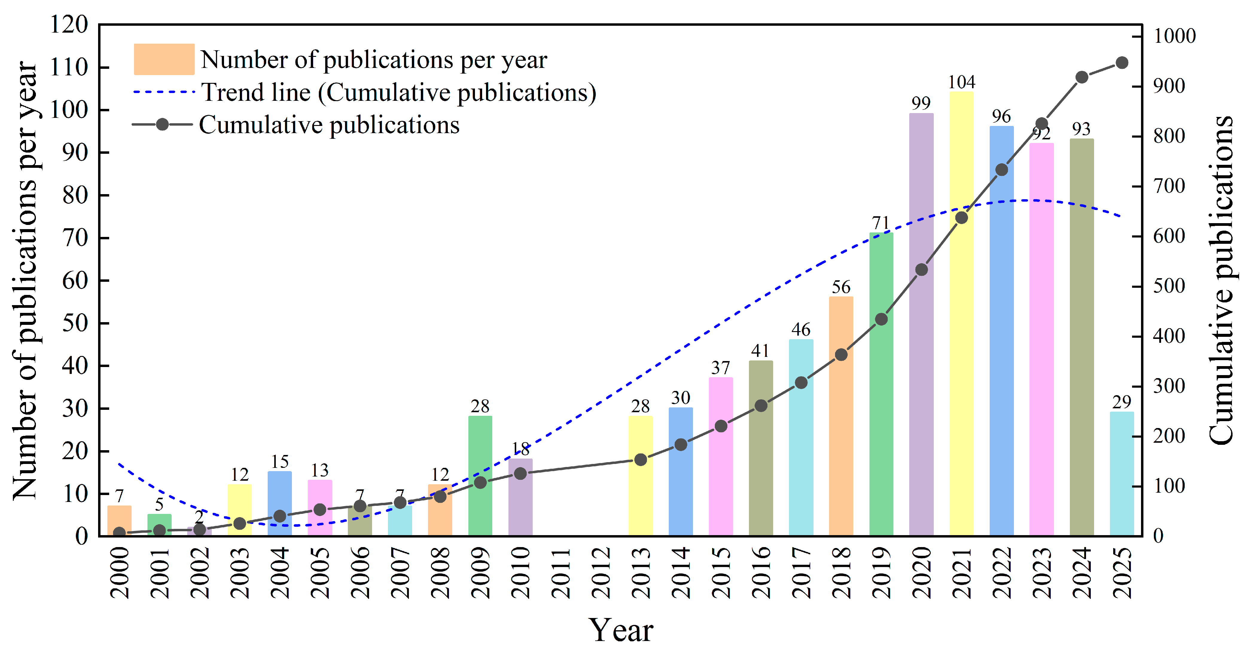
3.1. Analysis of Annual Publication Trends

This study analyzes the publication trends in the field of earthen site surface conservation from 2000 to 2025, covering a total of 967 articles. As shown in Figure 3, the research output has increased significantly over the last two decades and can be divided into three main stages: the initial stage, the transitional stage, and the rapid growth stage.
This study divides the development of research on earthen site surface conservation into three stages, with the starting point of the growth phase being appropriately advanced to reflect the increasing volume of publications.
Initial Phase (2000–2007): During this phase, the number of journal publications was low, indicating that the field was in its infancy with a relatively stable cumulative growth rate. The overall publication volume remained limited, reflecting a slow development trend. Research efforts were still exploring and developing foundational theories and methodologies. At this point, there was no mature research framework or comprehensive theoretical system, and studies primarily focused on the basic issues of earthen site surface conservation with limited interdisciplinary integration.
Transitional Phase (2008–2014): This period witnessed moderate fluctuations in publication output, showing a trend of staged growth. By 2014, the cumulative number of publications had reached approximately 450. The increasing application of spatial technologies such as GIS and RS to earthen site surface conservation [25,52], the gradual introduction of heritage conservation policies, and the development of interdisciplinary research all contributed to the accelerated progress during this phase. It is worth noting that there was no significant publication output in 2011–2012. Researchers speculate that this gap may be due to a shift in focus; the early years (2008–2010) emphasized reinforcement techniques [8], while the later years (2013–2014) focused on deterioration mechanisms [15,53]. This two-year gap might represent a period of technical validation. Moreover, the widespread adoption of GIS and RS for conservation monitoring purposes occurred after 2014 [54]; in contrast, the years 2011–2012 were still dominated by single-discipline studies (e.g., archaeology, material science), resulting in fragmented publications without prominent research hotspots.
Rapid Growth Phase (2015–present): Since 2015, the number of annual publications has consistently increased, peaking at 104 in 2021. The cumulative number of publications has shown an exponential upward trend, reflecting the growing attention to this field. The surge in research can be attributed to the rise of digital conservation [55,56,57], the growing emphasis on sustainable conservation practices, and the promotion of international cooperative projects (e.g., UNESCO’s Asia–Pacific heritage conservation initiatives [58]). These developments highlight the fluctuating nature of research activities over time and validate the delineation of the three stages.
Under the implementation of global heritage digitization strategies [59], advances in artificial intelligence [60], and especially the promotion of conservation work at earthen sites along the Belt and Road Initiative [15], research on earthen site surface conservation is expected to yield more innovations in technology and sustainability. This field will likely remain a research hotspot for a considerable time, with increasing scholarly output in the form of papers and monographs.

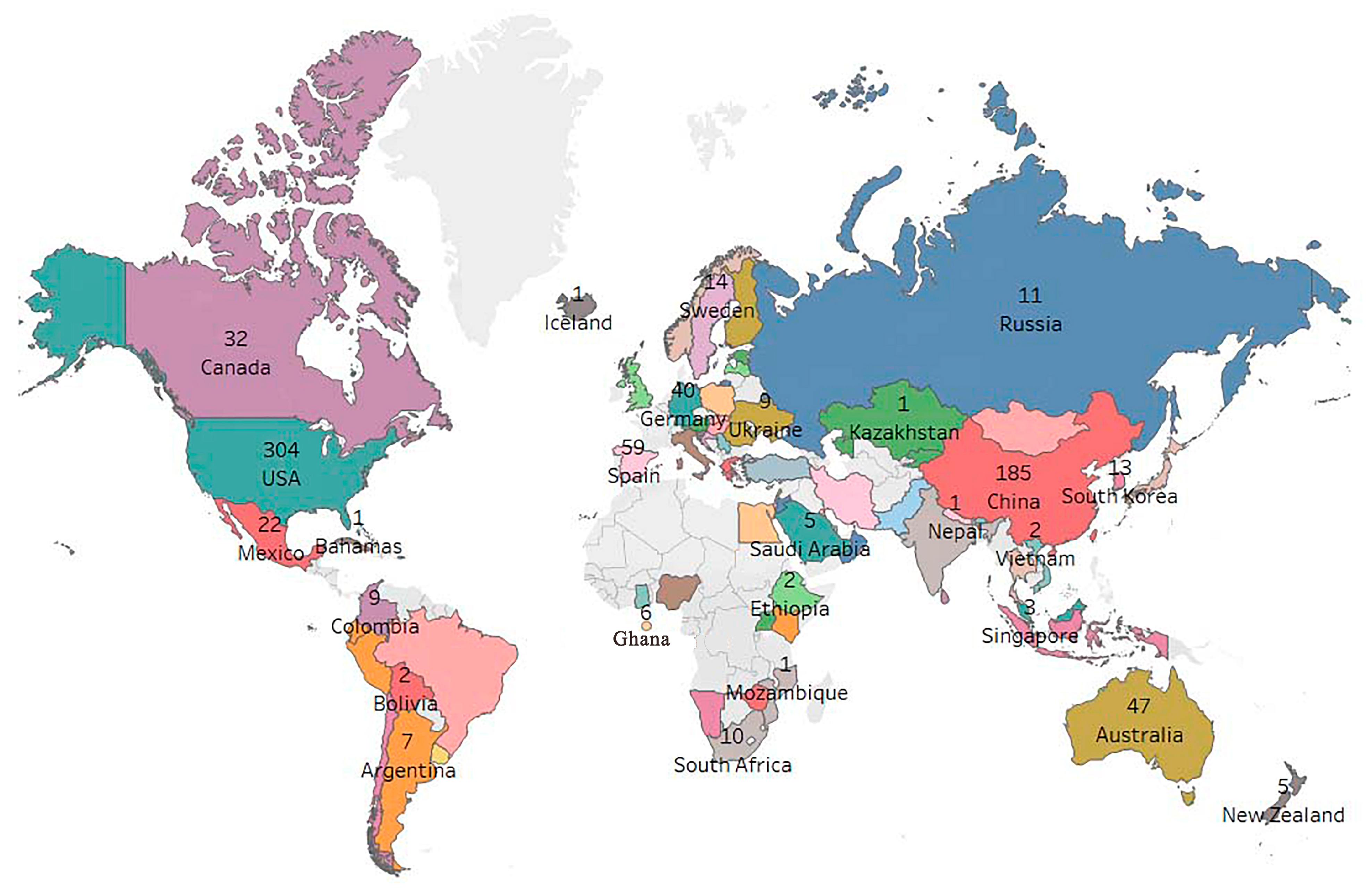
3.2. Active Countries/Regions

The analysis of publication volume by country/region reveals the global distribution of research in the field, highlighting the necessity of strengthening international cooperation through scientific collaboration platforms. Such cooperation facilitates the global flow and exchange of knowledge and technology, ultimately enhancing the overall quality of research. As shown in Figure 4, the global publication distribution map generated using MapBox 2025 v11.13.0 (https://www.mapbox.com/ (accessed on 17 July 2025)) illustrates the number of publications by country through color coding and numerical labels. It can be observed that countries in North America, East Asia, Europe, and Oceania stand out with relatively high publication volumes, indicating strong research capacities. In contrast, countries in Africa, Central Asia, and South America generally show weaker research performance in this field, with some countries lacking data or having zero publications, resulting in blank areas on the map. And the publication gap between the United States (304 articles) and China (185 articles) may be influenced by the database’s preference for English-language literature, rather than reflecting an actual disparity in research capacity. In addition, data gaps in regions such as Africa are not examined in terms of whether they result from the limited distribution of earthen sites or a lack of research resources.
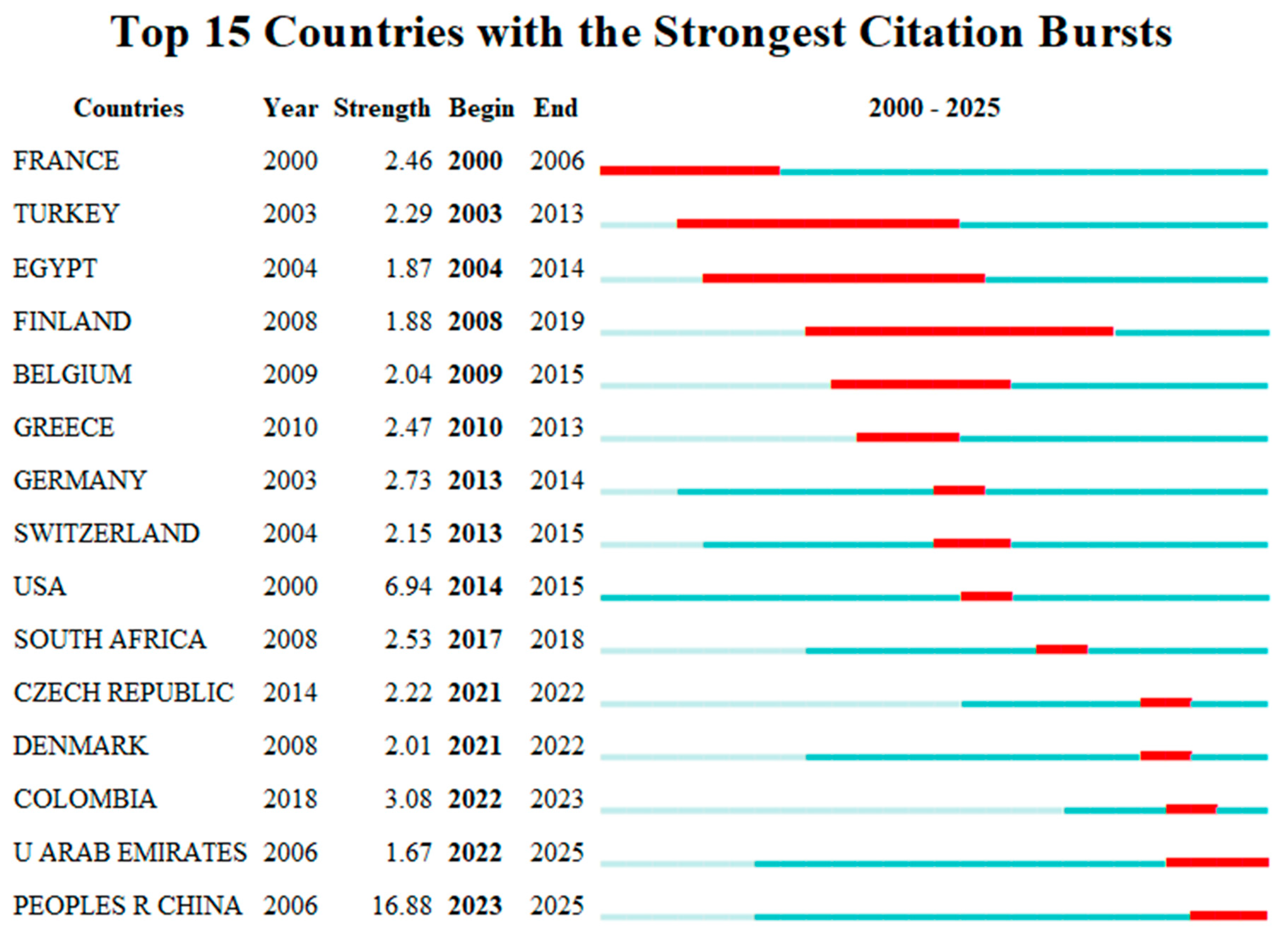
Figure 5 illustrates the top 15 countries/regions with the most significant citation bursts in the field of spatial conservation of earthen sites between 2000 and 2025. Citation burst analysis helps identify countries or regions whose publications have been cited intensively within a specific period, thereby indicating their rising influence in the field. Using CiteSpace, the analysis was conducted by setting the parameter to “Burst terms” to generate a burst detection map. A total of 15 countries were identified as having significant bursts. In this figure, Year indicates the first year that a country experienced a burst, while Strength denotes the intensity of the citation burst [61]. The light blue bars represent the full time span (2000–2025), the red segments indicate the duration of the burst period, and years without significant changes are filled in dark blue. The analysis reveals that most citation bursts occurred between 2000 and 2015, reflecting a growing interest in surface conservation research during that period. In recent years, a new wave of burst countries has emerged—including Colombia, the United Arab Emirates, China, and Denmark—suggesting renewed global attention to the field. Among these countries, China experienced a burst from 2023 to 2025, with the highest strength value of 16.88, indicating a rapid ascent in global influence and a growing leadership role in the field. Although China shows the highest burst intensity (16.88) during 2023–2025, there is no comparison of the citation impact of journals between China and the United States, making it insufficient to assess international recognition based solely on burst intensity. In contrast, the USA had an earlier burst (2014–2015) with a strength of 6.94, confirming its early central position in the field but suggesting a tapering of global attention in recent years. Other countries such as Turkey, Germany, Greece, and Belgium experienced notable citation bursts between 2013 and 2020, demonstrating Europe’s early and solid research foundation in this area. Emerging research nations such as Colombia and the United Arab Emirates are gradually joining the ranks of high-impact contributors, indicating their potential to become major research forces in the near future.
Therefore, it is evident that China’s academic influence in the field of earthen site surface conservation continues to expand globally. The United States, on the other hand, demonstrates both strong international citation impact and a relatively high frequency of international collaboration, thereby exerting substantial global influence. These differences reveal that various countries have distinct understandings of the roles and developmental paths related to earthen site surface conservation. Overall, this analysis indicates that China is currently one of the countries conducting the most extensive research in this field, while also highlighting the academic interest, contributions, and recognition of research achievements from other nations. Future studies may further explore patterns of international collaboration and emerging research hotspots to support the sustainable development of this field.

3.3. Institutional Distribution Analysis
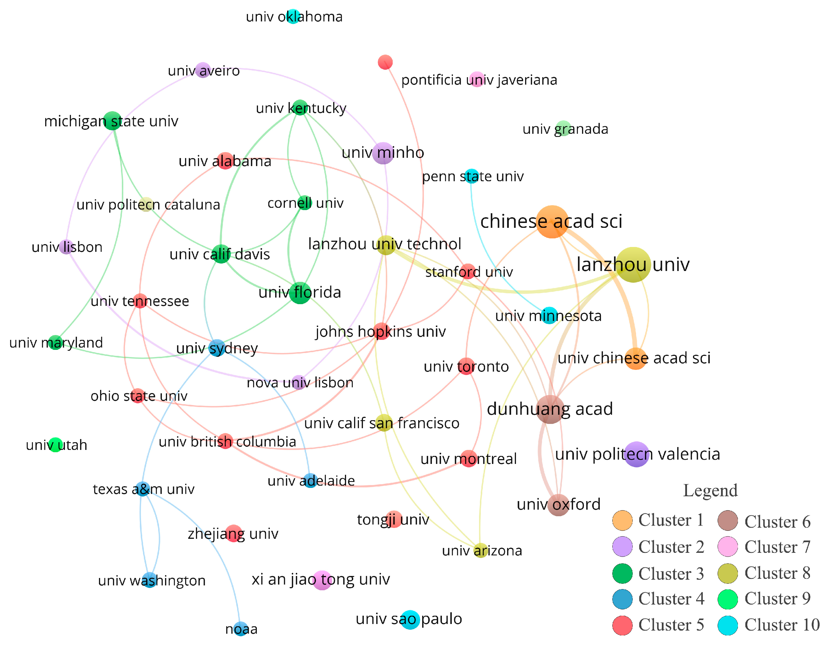
As shown in Figure 6, the VOSviewer software was used to analyze the research institutions active in the field of earthen site surface protection. A minimum threshold of two publications was set to ensure the clarity of the co-authorship network visualization. In the resulting visual map, each circle and text label represents an institution. The lines connecting the circles indicate co-authorship relationships, with the line thickness reflecting the strength of the collaboration. Gradient colors indicate the overall intensity of cooperation with other institutions, and the size of each circle is proportional to the number of publications produced by that institution [62]. Different colors represent distinct institutional clusters. For example, Cluster 1 includes the Chinese Academy of Sciences, Lanzhou University, and others. This cluster likely represents research forces centered on Chinese scientific research institutions and universities, mainly focusing on the theoretical foundations and material development for earthen site surface protection. Cluster 2 features institutions such as the University of Aveiro and the University of Minho, representing research groups from Portugal and other European countries that focus on techniques, methodologies, and protection management. Cluster 3, which includes several American universities, is likely oriented toward the use of advanced geographic information technologies and environmental monitoring techniques to observe and simulate the environmental conditions of earthen site surfaces. Connections between clusters show the presence of international collaborative research. For instance, the Chinese Academy of Sciences appears to collaborate with multiple international universities on research projects involving protective materials and monitoring technologies, including data and result sharing. In terms of institutional distribution, Chinese institutions dominate the field. The Chinese Academy of Sciences, Lanzhou University, Dunhuang Academy, and the University of Chinese Academy of Sciences are represented by relatively large circles, indicating a high volume of publications. The Dunhuang Academy, for example, has a high citation count (325 times) and an average citation rate of 17.1053, demonstrating significant academic impact. Lanzhou University has a relatively recent average publication year, indicating active and ongoing research in recent years. Domestically, institutions such as the Chinese Academy of Sciences and the University of Chinese Academy of Sciences, as well as Lanzhou University and Lanzhou University of Technology, are connected by thick lines, reflecting strong internal collaboration. Among international institutions, Michigan State University, Cornell University, and Stanford University have produced notable research outputs. However, their smaller circle sizes and thinner lines connecting them to Chinese institutions suggest a limited scale of international collaboration. The Chinese Academy of Sciences and Lanzhou University demonstrate close collaboration with dense linkages; however, the technological innovativeness and practical applicability of their joint research are not indicated. The sparse connections with overseas institutions are not analyzed in terms of whether they result from data-sharing barriers or insufficient international exchange. For example, Cornell University has an average publication year of 2012, indicating that its research activity peaked earlier and has decreased in recent years.
Figure 7 illustrates the top 20 most-cited institutions worldwide in the field of earthen site surface protection from 2000 to 2025. Notably, early research was predominantly led by US institutions—such as the United States Department of Agriculture and the University of California System—which laid the theoretical groundwork for the field. In the mid-term period, European institutions such as the University of Minho and Universitat Politècnica de València became prominent, focusing on the expansion and application of new technologies. In recent years, Chinese institutions have experienced a rapid surge in influence. Lanzhou University (2019–2025) stands out with a burst strength of 5.15, ranking first in the world in the field of earthen site surface protection, significantly ahead of other global institutions. Both Xi’an Jiaotong University (2022–2025) and the University of Chinese Academy of Sciences (2022–2025) also demonstrate strong intensity and sustained research activity. This trend indicates that China has shifted from merely participating in the field to playing a leading and demonstrative role, establishing a certain degree of international discourse power in the realm of earthen site surface protection. Lanzhou University (burst intensity: 5.15) shows a high burst, but its core technological focus is not specified (e.g., whether it concentrates on earthen sites in arid regions of Northwest China), making it difficult to infer the universality of its technologies. The burst of Xi’an Jiaotong University (2022–2025) does not indicate its collaborative relationships with other institutions.
Overall, Chinese research institutions have become a vital component of the global academic community, characterized by high research output and strong internal collaboration. However, international cooperation with institutions abroad still requires further strengthening. Moving forward, it is essential to promote a more integrated and interdisciplinary collaborative mechanism between domestic and international research bodies to advance the global development of research in this field.

3.4. Analysis of Research Authors

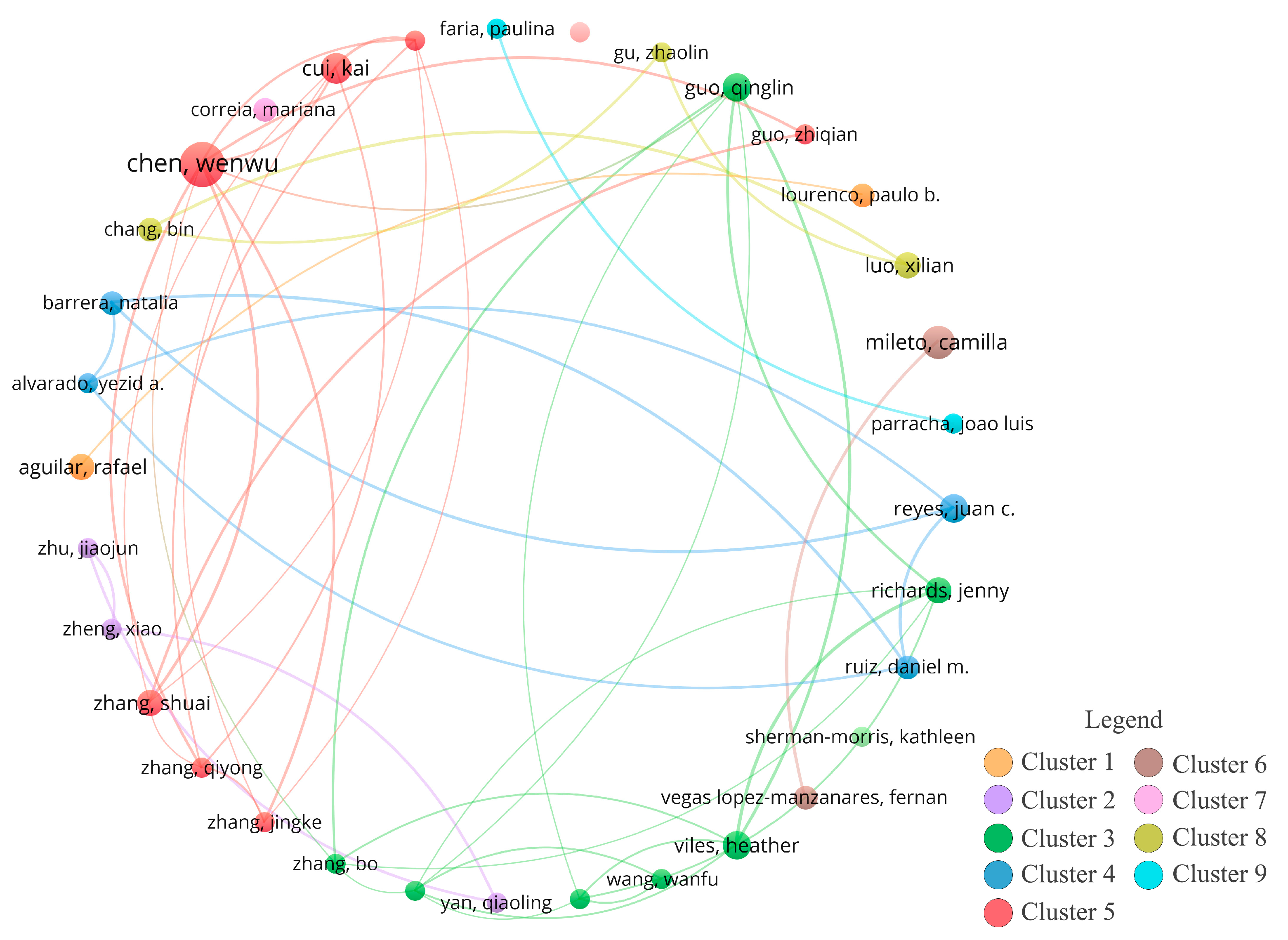
To reveal the collaborative relationships among authors, a co-authorship analysis was conducted using VOSviewer, as shown in Figure 8, with the minimum publication threshold set at two papers per author. This analysis generated a co-authorship network map for researchers in the field of earthen site surface protection. Each circle in the map represents an individual author; the larger the circle, the more frequently the author appears or the more actively they are involved. Lines between circles indicate collaboration strength—thicker lines suggest stronger ties and more frequent co-authorships. Different colors represent distinct author clusters, indicating tighter intra-cluster relationships.
For example, Cluster 5 consists primarily of Chinese scholars whose research focuses on domestic earthen site surface protection, particularly in areas such as crack disease prevention and reinforcement materials for earthen sites in arid regions of northwest China. These researchers possess a strong foundation in local studies and practical experience. Cluster 3, by contrast, may include scholars from the UK, the US, and other Western countries who utilize advanced monitoring technologies and geographic information systems in their research, emphasizing environmental monitoring and data analysis of earthen site surfaces.
The lines connecting different clusters reflect instances of collaboration across groups, facilitating knowledge exchange. For instance, expertise in site management and planning from one cluster can inform strategies in others, while practical findings on disease prevention in earthen structures may offer useful insights to international peers. The visualization highlights that Chinese scholars form the core research cluster, with authors such as Chen Wenwu, Guo Qinglin, and Cui Kai appearing as large, densely connected nodes, indicating strong influence and leadership within the field. International scholars such as Lourenço Paulo B. and Heather Viles have also made significant contributions; however, their connections with Chinese scholars appear sparse, reflecting a relatively weak international collaboration network.
Overall, while there remains substantial room to enhance global collaboration, the trend also reflects the rapid advancement and emergence of new academic forces in the field of earthen site surface protection worldwide.
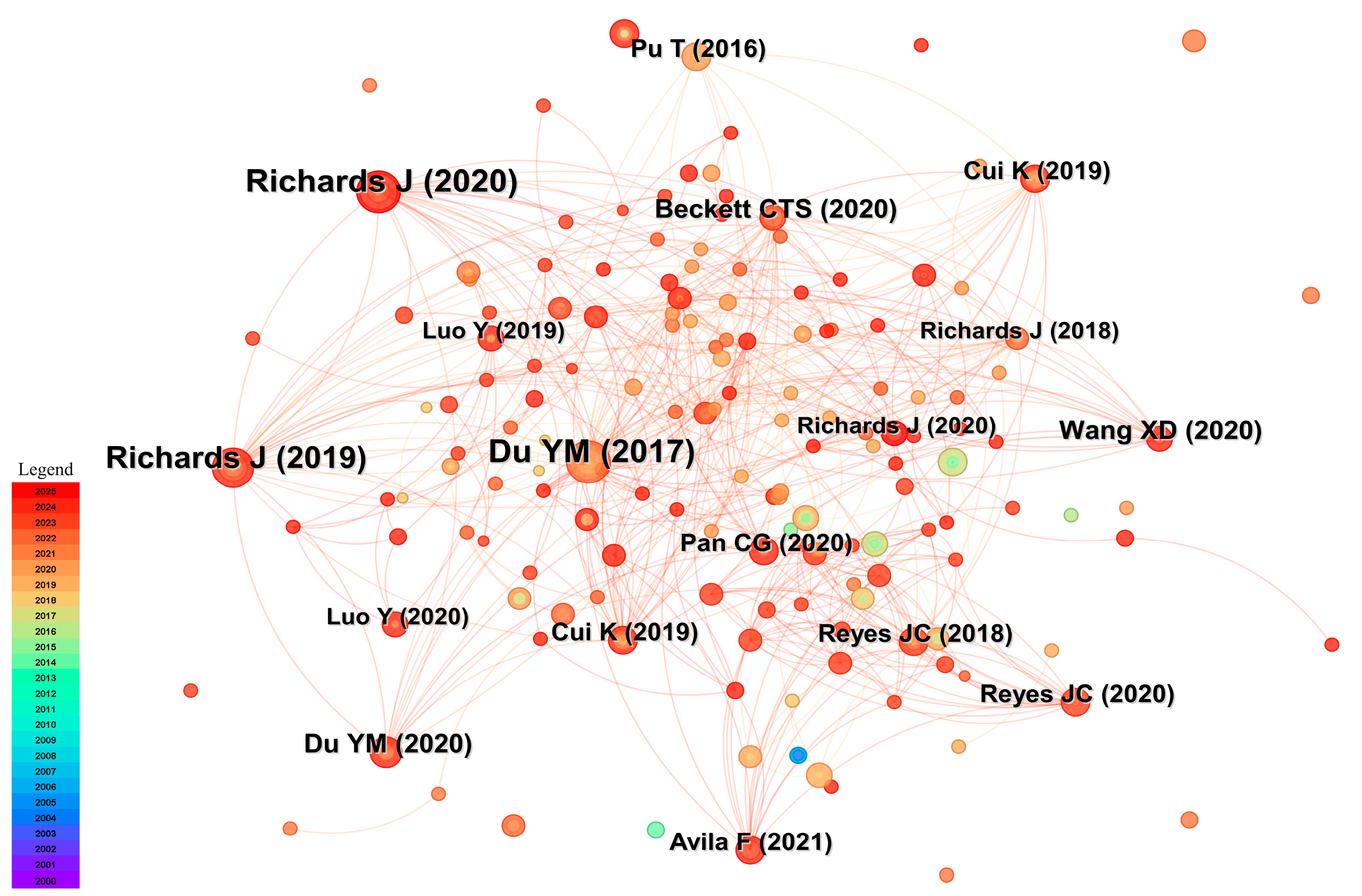
Figure 9 displays the top 10 authors worldwide with the most significant citation bursts in the field from 2000 to 2025. The citation burst analysis identifies authors whose publication frequency or citation rate has increased markedly during a specific time period, helping to reveal the field’s core contributors, emerging research trends, shifting focuses, and evolving hotspots. The author with the highest burst strength is Alvarado, Yezid A., whose citation burst began in 2022 and lasted through 2023, with a burst strength of 2.18. His research during this period gained substantial attention within the academic community. The author with the longest burst duration is Aguilar, Rafael, who maintained a high burst level from 2015 to 2019. His work has had a long-lasting influence and significant impact on subsequent studies. In recent years, Zhang, Shuai has also emerged as an influential scholar in the field, with growing recognition and impact for his recent research. These findings indicate that research in the field is undergoing a period of rapid development, marked by the emergence of a new generation of influential academic contributors.

3.5. Journal Co-Citation Analysis

In VOSviewer, a hotspot density map (or “cloud map”) visually represents the distribution of research hotspots within a field by illustrating the co-occurrence frequency or association strength of entities such as keywords, documents, or authors through color gradients and density. Typically, the color scheme ranges from cool tones (e.g., blue) to warm tones (e.g., yellow), with warmer colors indicating higher co-occurrence frequencies or stronger associations, thus signifying core research hotspots in the field. Higher density—indicated by denser clusters of points—reflects more frequent co-occurrences, suggesting that the research themes in that area are more focused. In contrast, isolated keywords may represent peripheral topics or emerging directions. Clusters of varying sizes correspond to distinct thematic areas.
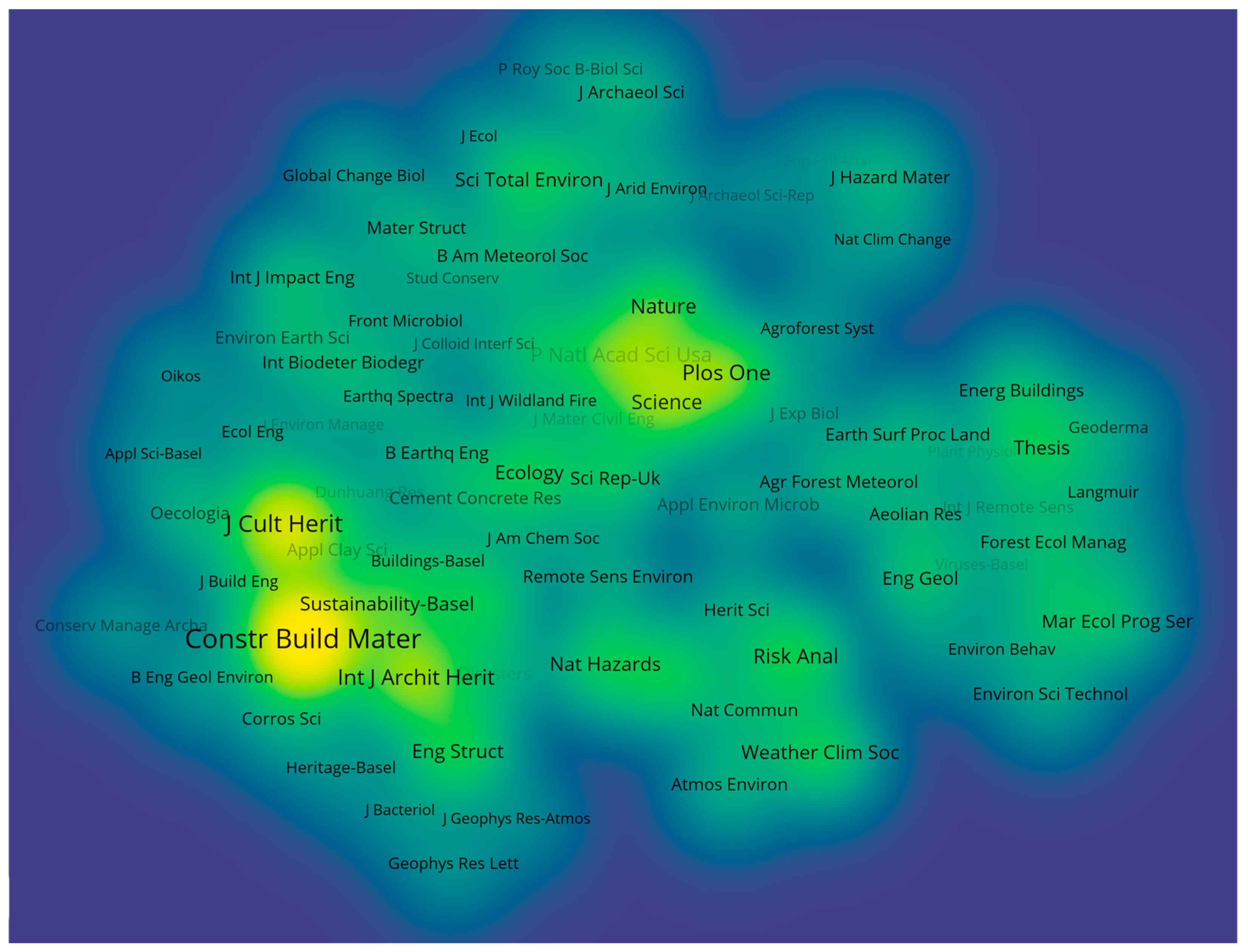
Figure 10 presents a hotspot journal density map in the field of earthen site surface protection. Analysis reveals that the Journal of Cultural Heritage, Construction and Building Materials, Nature, and Science exhibit high cluster density and occupy the core of the hotspot map, marking them as authoritative and influential journals within the field. However, top-tier comprehensive journals such as Nature and Science may exhibit high clustering intensity due to interdisciplinary reviews or research, rather than systematic contributions to surface conservation technologies for earthen sites. In contrast, specialized journals such as the Journal of Cultural Heritage account for a larger proportion of publications on earthen site conservation, with a focus on core hotspots such as material development and monitoring technologies. Their role in technological leadership is weakened by the generalized representation of “hotspot clusters” in the diagram. Conversely, journals such as Geophysical Research Letters and Journal of Bacteriology exhibit lower cluster densities and are typically interdisciplinary in nature—related to geophysics or microbiology—with more indirect links to earthen site surface protection. Heritage-Basel appears in a bright color and forms an independent cluster, reflecting its focus on international heritage protection and signaling an emerging trend in the field. Core journals identified in the visualization can serve as key sources for literature review, while newly emerging journals often indicate potential research frontiers. Overall, the journal hotspot map offers a clear overview of journal distribution, disciplinary structure, and development trends in the field of earthen site surface protection, providing a valuable reference for future research planning.
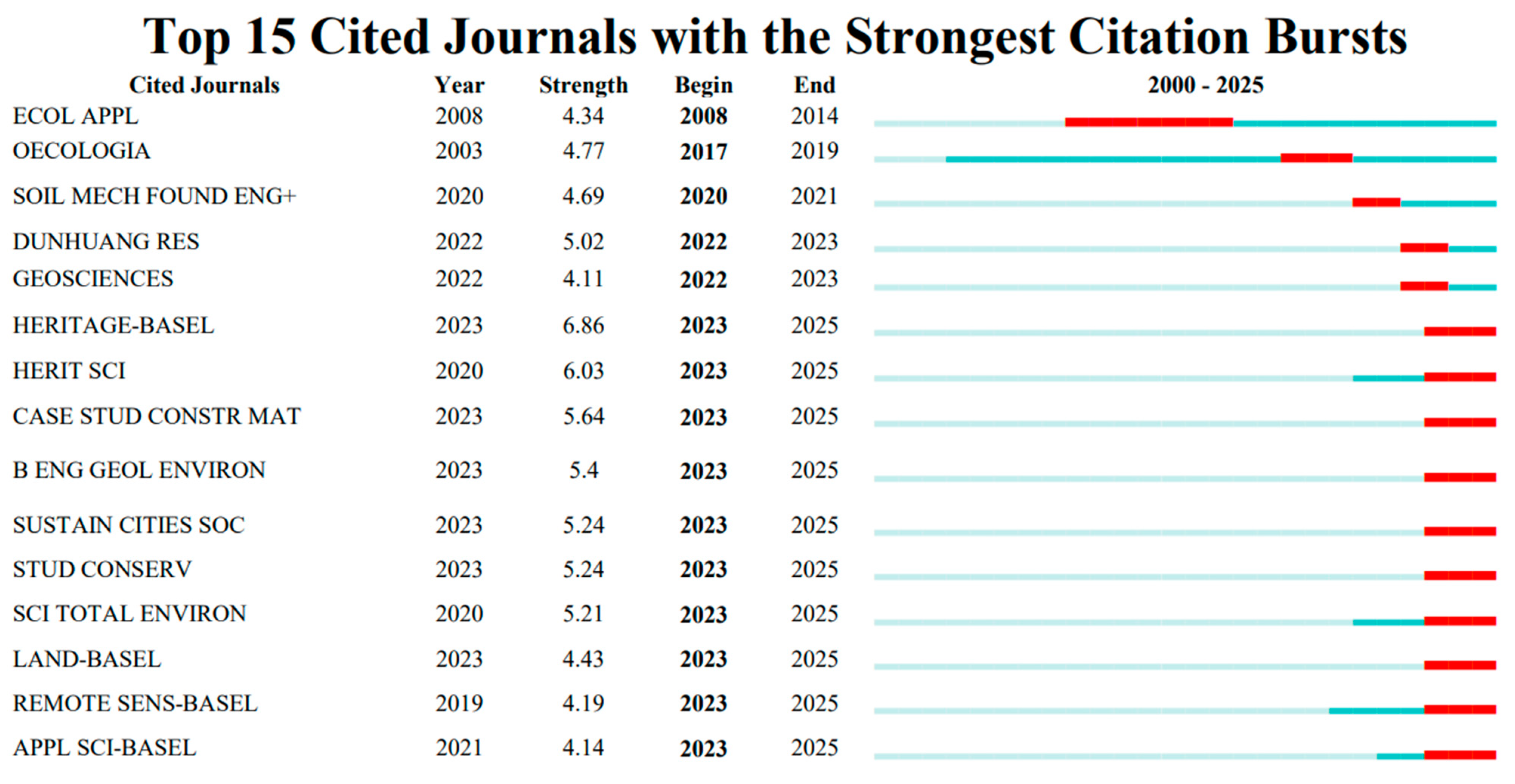
Figure 11 presents the top 15 most-cited academic journals from 2000 to 2025. The data show that Heritage-Basel (6.86, 2023–2025) and Heritage Science (6.03, 2023–2025) exhibit the highest burst intensities, indicating that these two journals have had the greatest impact on academic research in their respective fields during this period. This suggests that research on earthen site surface protection has become a central focus in recent years. Additionally, journals such as Remote Sensing-Basel and Geosciences have shown strong citation trends since 2022, reflecting the growing application and influence of remote sensing and geophysical technologies in the field of earthen surface protection. Their rising attention in academic circles highlights significant advancements in related studies. The strong performance of these journals demonstrates their critical roles within their domains, and the duration and intensity of their citation bursts underscore their importance in driving academic research and the dissemination of knowledge.

3.6. Document Co-Citation Analysis

Figure 12 presents an analysis of the citation frequency network based on the core literature published between 2000 and 2025. Using the CiteSpace software, the visualization illustrates the citation relationships among different publications, thereby helping to identify the most influential papers and scholars in the field. Each node represents a cited reference, and the larger the node, the more frequently the reference has been cited, indicating greater academic influence. The color gradient—from cool colors (blue, purple) to warm colors (yellow, orange)—represents the temporal span of citation activity. The connecting lines between nodes indicate citation relationships; the quantity and density of these lines reflect the closeness and academic relevance between references. Different colors of the lines correspond to citation relationships established during different time periods. Prominent nodes such as Richards, J. (2020) [63], Richards, J. (2019) [64], and Du, Y.M. (2017) [65] are frequently cited, demonstrating their high impact and foundational role in the field of surface protection of earthen sites. Moreover, the connections among these highly cited papers suggest that they are often co-cited in the same references, indicating thematic similarities. This further confirms the significant influence that these works have exerted on the research domain of earthen site surface conservation.

3.7. Keyword Co-Occurrence Cluster Analysis

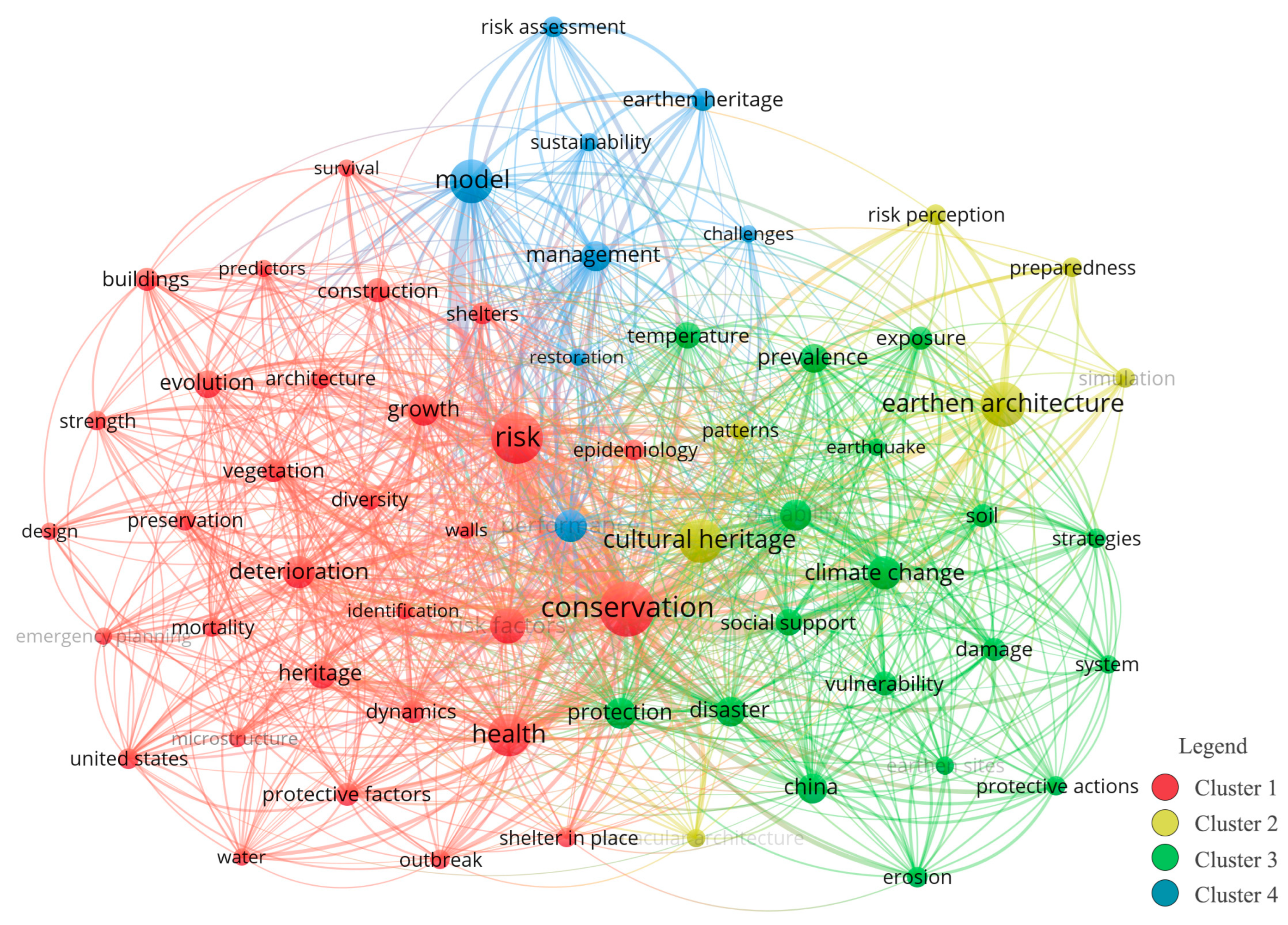
Keyword clustering reveals the distribution and interrelations of various research hotspots, thereby reflecting the primary thematic focuses in the field of surface protection of earthen sites. As illustrated in Figure 13, this study conducted a keyword co-occurrence cluster analysis using the VOSviewer software. By setting the minimum occurrence threshold to 30, a total of 155 keywords were extracted from 18,467 keywords, resulting in a clear and detailed visualization. In the map, each node consists of a circle and a label, where the size of the circle indicates the frequency of the keyword’s occurrence, and the thickness of the connecting lines represents the strength of the relationships between keywords. Different colors represent distinct research emphases, forming four separate clusters. This approach effectively highlights the domain’s key areas of interest and provides insight into the evolving academic trends and emerging themes in the surface protection of earthen sites.
Cluster 1 (Red) focuses on risks and health-related conservation of earthen sites. Keywords include “risk,” “health,” “conservation,” and “cultural heritage.” This cluster centers on the various risks facing earthen site surfaces and explores how to ensure their healthy survival [33]. Emphasis is placed on the attributes of cultural heritage during protection processes, discussing how to balance risk response and heritage conservation, preserve traditional characteristics, and incorporate contemporary conservation approaches.
Cluster 2 (Green) centers on the natural environmental impacts on earthen site surfaces and corresponding conservation strategies. Keywords include “earthen architecture,” “climate change,” “soil,” and “erosion.” This cluster analyzes environmental factors such as climate change, soil conditions, and erosion that affect the surface of earthen sites and explores nature-based conservation strategies and interventions.
Cluster 3 (Blue) highlights the development of models and management systems for the surface protection of earthen sites, with keywords such as “model,” “management,” “sustainability,” and “earthen heritage.” This research cluster delves into the construction of quantitative models for surface protection and the establishment of scientific management systems, analyzing the driving mechanisms behind sustainable development and their implications for managing the surface conservation of earthen sites [21].
Cluster 4 (Yellow) addresses risk perception and response strategies related to earthen site surfaces. Notable keywords include “risk perception,” “preparedness,” “simulation,” and “challenges.” This cluster emphasizes a multidisciplinary approach to understanding public and professional perceptions of risks to earthen site surfaces. It examines the challenges through simulation methods and explores preparedness strategies, offering comprehensive approaches to enhance the effectiveness of surface protection for earthen sites.
However, there is a lack of representation for cross-disciplinary technological domains. For instance, “climate change” in the green cluster and “sustainability” in the blue cluster are connected by a relatively thin line in the diagram, which fails to reflect the strong causal relationship that exists in the surface conservation of earthen sites. Some cutting-edge technology keywords, such as DT, are absent from high-frequency clusters, resulting in a disconnect with the conclusions on “intelligentization” and “sustainabilization.” This may be due to the keyword filtering threshold (a minimum of 30 occurrences), which excludes emerging terms within the field and hinders the clustering results from capturing the trends of technological integration.
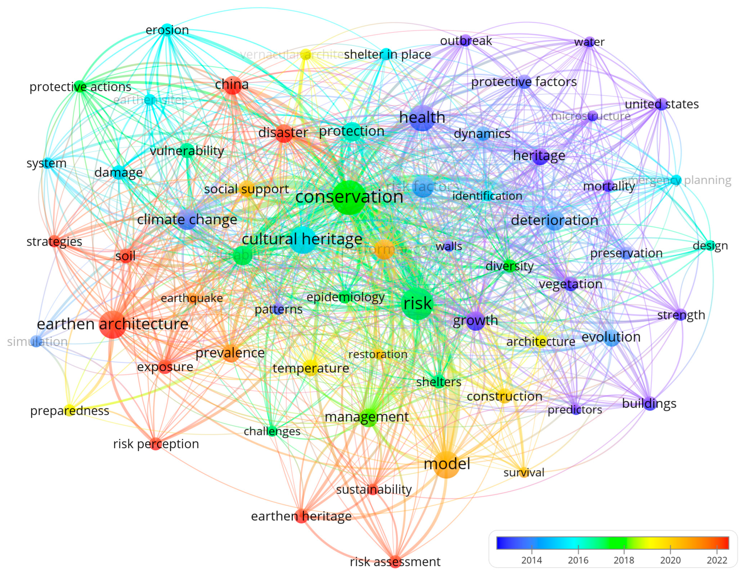
The keyword temporal frequency map (Figure 14) illustrates the frequency and temporal distribution of keywords over time. The relationships among keywords help reveal thematic correlations within the research field and uncover the dynamics of academic development and emerging hotspots. In this visualization, each node consists of a circle and a label. The size of the circle is proportional to the frequency of keyword occurrence—larger circles and fonts represent higher frequencies. Lines between nodes indicate co-occurrence relationships, with line thickness reflecting the strength of those connections. The color of each circle, as indicated by the gradient legend in the bottom-right corner, represents the average year of occurrence. Blue indicates earlier appearance, while orange indicates more recent usage. For example, keywords such as “deterioration” and “heritage” are concentrated in the earlier, blue-colored region, reflecting early research interests. In contrast, keywords such as “sustainability” and “risk assessment” appear predominantly in the more recent, orange-colored region, indicating that they have become major focal points in the field in recent years.
This study reviews nearly 25 years of research on earthen site surface protection and proposes a five-phase model of the literature’s evolution based on the keyword co-occurrence frequency and the temporal distribution of emerging keywords. Although the time intervals of each phase differ, the distinct characteristics and varying rates of development effectively reflect the corresponding stages of research progress. The first phase (2000–2014), lasting 15 years, primarily focused on the attributes and characteristics of earthen sites themselves and the establishment of theoretical frameworks for surface protection through case studies. This phase marks the initial stage of research on earthen site surface protection, which is characterized by relatively slow development. In contrast, the third phase (2018–2020) lasted only 3 years, coinciding with a period of technological integration. The widespread application of GIS and RS technologies greatly accelerated the advancement of earthen site surface protection, making it more intelligent and precise.
Phase 1 (2000–2014): Key hotspots during this period include “Heritage,” “Cultural Heritage,” and “Risk Factors.” Research emphasized the cultural heritage value of earthen sites [16], deepening the understanding of their significance from a broader heritage perspective. The foundational frameworks for protection and risk response were developed [66], establishing theoretical underpinnings such as protection goals and risk classification, which later facilitated digital-technology-based research [67].
Phase 2 (2014–2016): Keywords such as “Earthen Sites,” “Climate Change,” and “Vulnerability” emerged [68]. This phase focused on refined analyses of earthen surface types and their correlations with climate change and vulnerability. The increasing attention to vulnerability mechanisms under environmental change marked a shift toward natural-environment-centered approaches to discovering new methods of surface protection [69,70].
Phase 3 (2016–2018): Hot keywords included “Conservation,” “Durability,” and “Management.” The visualization results show that “Conservation” remained central in the keyword network, continuing the core agenda from earlier stages. Protection during this phase emphasized scientific and systematic approaches, shifting from conceptual frameworks to assessments of practical effectiveness and long-term feasibility. The prominence of “Durability” reflects growing concern with material weatherability and damage resistance [71]. The close linkage between “Management” and “Conservation” signals the transformation of theory into operational management systems, such as the development of risk assessment models or the incorporation of sustainable strategies addressing ecological, economic, and social dimensions [72,73].
Phase 4 (2018–2020): The key terms were “Model,” “Construction,” and “Architecture Evolution.” This phase signaled a transition toward practical implementation, with emphasis on applying surface protection technologies to real-world contexts. The emergence of “Model” indicated efforts to develop and apply quantitative models for dynamic simulations and data-driven decision making [74]. “Construction” highlighted the use of new materials and techniques for surface repair and reconstruction [75]. “Architecture Evolution” reflected studies on how natural and anthropogenic forces alter earthen site surfaces, while architectural and mechanical knowledge was leveraged to enhance conservation strategies, such as in situ preservation [70,76].
Phase 5 (2020–2025): Emerging keywords include “Strategies,” “Risk Perception,” and “Sustainability.” This phase centers on integrating various protection methods into comprehensive strategies. Greater attention is paid to understanding risk perceptions and advancing the sustainable development of earthen sites across ecological, economic, and social domains [77]. The rise of “Sustainability” as a core keyword reveals a heightened emphasis on the synergy between long-term development and surface protection, echoing the field’s alignment with broader societal demands for ecological and socioeconomic sustainability [78] and promoting the dual goals of cultural heritage preservation and environmental conservation [79].
Figure 15 illustrates the top 15 most frequently cited keywords in the field of earthen site surface protection research between 2000 and 2005. Keywords such as “risk factors” and “cultural heritage” represent the academic focal points of that specific period. This analysis not only reveals the dynamic evolution of research hotspots across different stages but also reflects the shifting frontiers and focal themes within the field of earthen site surface protection. Among them, “cultural heritage” exhibits the highest burst intensity, with a rate of 4.7 during the burst interval of 2015–2021, indicating significant scholarly attention to topics related to cultural heritage in recent years. It is worth noting that there is an issue of term generalization regarding core concepts. For example, “cultural heritage” exhibited the highest burst intensity of 4.7 during 2015–2021, but it did not differentiate its proportion between earthen sites and other heritage types (such as stone heritage). As a distinctive type of heritage, earthen sites require targeted surface conservation technologies (e.g., rammed earth reinforcement, wind erosion control). The generalization of this keyword may obscure the lack of specialized technological research on earthen sites, leading to biased judgments on core issues within the field. In addition, keywords such as “earthen architecture” (2008–2025, burst intensity: 3.25) and “resilience” (2010–2020, burst intensity: 3.25) also show strong burst trends, highlighting major academic interest and activity within the domain. This trend suggests a global academic shift from the early focus on traditional risk factors to broader concerns regarding the relationship between large-scale sites and cultural heritage, as well as the development of long-term protection mechanisms. The emergence of these keywords not only underscores current research frontiers and hotspots but also helps scholars identify potentially significant future directions, such as in-depth studies around emerging keywords such as “heritage conservation” (2023–2025) and “earthen site” (2023–2025).
Based on the above visualization results, the research trajectory of surface protection for earthen sites can be interpreted through a dual-dimensional lens of temporal distribution and burst intensity. In the early stage, foundational concepts such as “Cultural Heritage” appeared early and maintained a strong citation burst (4.7), consistently occupying a dominant position. With theoretical advances and technological progress, keywords such as “Resilience” emerged in the transitional zone of the keyword temporal frequency map, accompanied by a notable citation burst, marking a shift from theory-oriented to practice-driven research. In the later stage, the term “Sustainability” becomes prominent in the frequency timeline, while “Heritage Conservation” and “Earthen Site”—which exhibit strong citation bursts from 2023 to 2025—act as complementary indicators. Together, these patterns suggest a developmental trajectory that moves from foundational studies toward a sustainability-oriented research paradigm.

4. Discussion

4.1. Problem Revelation and Method Innovation

A review of the research on the surface protection of earthen sites over the last 25 years reveals a clear trend toward digital transformation. However, notable deficiencies remain in capturing surface deterioration details, enabling real-time monitoring, and ensuring long-term effectiveness. Although promising progress has been made in the application of digital technologies and interdisciplinary collaboration, certain limitations and contradictions persist, hindering the evolution of protection paradigms. As shown in Table 1, research hotspots currently focus on the application of advanced digital technologies, yet the limited depth of technological integration constrains the development of dynamic protection capabilities. In terms of keyword trends, there has been a shift from basic surface protection in earlier studies toward sustainable surface protection in recent years. This shift highlights a gap in interdisciplinary theoretical collaboration, as a systematic protection framework has yet to be fully established. Regarding research trends, while there have been explorations in constructing digital technology repositories and integrating them with city information modeling (CIM), the lack of interdisciplinary theoretical support often results in a disconnect between technological applications and practical protection work.
Based on the issues discussed above, it is suggested that a digital technology database for earthen sites should be developed [11,82]. This would allow for the integration of currently fragmented technologies into a systematic structure that connects digital technology theory with practical applications. Furthermore, on this foundation, an interdisciplinary framework integrating the theory of CIM [83] should be established, incorporating insights from archaeology, computer science, and other disciplines to address the current theoretical gaps. With the digital technology database as a foundation, tailored solutions can be proposed for different heritage, ecological, and community protection needs across varying timeframes. This will enable the iterative updating of conservation methods throughout both short-term protection and long-term evolution processes, advancing the development of a CIM-based coordinated conservation system.
In terms of methodology, this study does not rely solely on visualized outputs from VOSviewer and CiteSpace for bibliometric analysis. Instead, it incorporates in-depth manual reading of the key literature and employs GPT-assisted analysis to go beyond the traditional surface-level interpretations of bibliometric data visualizations, thereby uncovering trends in cutting-edge technologies for surface protection of earthen sites [84]. The value of GPT-assisted semantic mining in the methodology of this study is reflected in three aspects. 1. It compensates for the limitation of traditional quantitative methods that prioritize data over logical reasoning. In this study, semantic association is used to reveal the internal driving mechanism of the “digitization–intelligentization–sustainabilization” technological integration. 2. It addresses the challenge of identifying theoretical discontinuities in interdisciplinary research. For example, by using GPT-assisted analysis to examine the correlation between meteorological data and studies on the performance of reinforcement materials, theoretical gaps are identified, enabling the construction of interdisciplinary deterioration prediction models. 3. It enhances the credibility of the conclusions by quantitatively extracting the core points of the literature and validating the rationality of the three-stage technological evolution (single-point monitoring–spatial modeling–intelligent integration). GPT was used as a preliminary tool to extract information and key points from the literature, while the researchers applied professional judgment to review, revise, and supplement the preliminary outputs, performing in-depth analysis and making final decisions. This approach ensured the accuracy and reliability of critical information in the literature [85]. The analysis thus established a multi-level framework combining a qualitative close reading with quantitative technical analysis, revealing the underlying logic of theoretical innovation and technological advancement, and guiding the field toward deeper and more comprehensive development.

4.2. Analysis and Interpretation of Hot Literature

This study conducts a comprehensive analysis of the research content of hotspot articles to summarize the current state of research on surface protection of earthen sites. As shown in Table 2, a multi-technology collaborative monitoring system has gradually taken shape, with increasing emphasis on the coupling of natural and human-induced factors. The trend toward interdisciplinary integration is evident, and emerging technologies such as DT are being applied to enable preventive protection. Looking ahead, further research is needed on multi-physical field coupling, the development of standardized technical systems, the promotion of AI and DT applications, the expansion of VR-/AR-based site presentation, and the enhancement of international cooperation and cross-disciplinary integration, with greater attention to the synergy between heritage conservation and sustainable development.
Current research on the surface protection of earthen sites builds upon the foundational understanding that surface deterioration is primarily driven by environmental factors (e.g., freeze–thaw cycles, wind erosion). However, by conducting multi-field coupling experiments that accelerate the deterioration process, researchers have proposed the concept of a “deterioration chain,” thereby expanding the traditional view of single-factor influence. The application of SBAS-InSAR technology in conjunction with LiDAR and unmanned aerial vehicle (UAV) collaborative modeling has further advanced earlier approaches that relied on RS and GIS for surface spatial analysis. This combination of LiDAR and UAV addresses the limitations of using single-source RS data and the inefficiencies of labor-intensive field methods (such as manual comparative experiments), enhancing overall efficiency and mitigating data deficiencies [64]. Moving forward, it remains essential to deepen the investigation of multi-field coupled deterioration mechanisms, establish standardized protection technology systems, and further apply cutting-edge digital technologies in practice. In particular, greater emphasis should be placed on exploring synergistic pathways between the surface protection of earthen sites and sustainable development.

4.3. Research Hotspot Transformation and Development Trends

The current challenges facing the surface protection of earthen sites stem from the dual impact of climate change and anthropogenic damage. Traditional protective technologies are inadequate for addressing the synergy between micro-scale deterioration and macro-environmental shifts, necessitating a shift toward digital preservation and enhanced international cooperation. The theoretical rationale for this trend is as follows: (1) as illustrated in the keyword co-occurrence map, terms such as “climate change,” “disaster,” and “risk factors” demonstrate strong interconnectivity, highlighting the global risks and challenges posed by climate change and disasters to the surface protection of earthen sites [69,88]. The integration of digital technologies enables global collaborative monitoring through tools such as the IoT for disaster detection [89,90] and artificial intelligence (AI) for simulating climate change impacts [91]. These technologies facilitate comprehensive risk monitoring and early warning, as well as the sharing of monitoring data and coordinated protection measures to address global climate-related risks [92]. (2) The burst keywords “cultural heritage” and “earthen architecture” underscore the global significance of earthen site surface protection. Accordingly, this study advocates for the development of a global deterioration database for earthen sites and the establishment of a unified protection technology model. This would facilitate a transition toward precise, sustainable, and internationalized protection, supporting the formation of a world heritage conservation system [7,93].
By analyzing the evolution of hotspot keywords in the field of earthen site surface protection from 2000 to 2025 (as shown in Table 3), it becomes evident that the shift has been driven by a combination of policy influence, climate change, technological advancement, international collaboration, and conceptual innovation. This has led to a transition from single-category structural protection toward a multi-category, full-life-cycle protection paradigm.
Based on the evolution of hotspot keywords, this study attempts to summarize the developmental pattern of earthen site surface protection into six stages after several rounds of selection.
(1)
Basic Protection Stage (2000–2010): Due to severe natural disasters and human-induced damage, earthen sites were in urgent need of protection during this period. Archaeologists began to explore the fundamental scientific issues related to earthen sites. The main focus was on the architecture and material mechanics of earthen sites, using simulation experiments to identify weak points in site walls and earthen structures [94,95]. A pioneering “risk factor” quantitative assessment framework was proposed [96], and univariate analyses on material mechanical properties were conducted [97]. However, a comprehensive protection system had yet to be established, and policy interventions were largely absent.
(2)
Policy Foundation Stage (2011–2015): This stage followed China’s endorsement of The Nara Document on Authenticity (Asia–Pacific region) [98]. During this time, the principle of authenticity was officially established, and earthen sites were incorporated into the legal framework of “cultural heritage” protection [99]. The research focus shifted from individual surface restoration to systematic protection. Emphasis was placed on minimal intervention techniques based on the theoretical principles of authenticity and reversibility [100,101]. Efforts were made to build international standard protection procedures and cooperation models, although the field was still in the early stage of multidisciplinary integration.
(3)
Transformation and Response Stage (2016–2018): With increasingly extreme global weather, earthen sites faced intensified damage from water erosion, salt corrosion, and thermal expansion and contraction [102,103,104]. “Climate change,” “water,” and “temperature” became key research topics in surface protection. Disaster modeling was introduced [105], and weather-resistant reinforcement materials were developed alongside on-site emergency response plans. The research emphasis shifted from static protection to dynamic prevention, following a multidisciplinary research path.
(4)
Conceptual Expansion Stage (2019–2020): The Paris Agreement emphasized synergizing carbon reduction with local development [106]. The keyword “resilience” surged in 2018 and became a central topic. This stage marked a shift beyond traditional protection concepts, incorporating approaches such as vegetation-based protection and microclimate regulation to enhance system robustness [107,108].
(5)
Innovation and Cooperation Stage (2021–2023): Advanced digital technologies rapidly developed during this period, with 3D laser scanning and BIM technology being widely applied in the surface protection of earthen sites [109,110]. At the same time, the Belt and Road Initiative facilitated international cooperation in the protection of earthen site surfaces [111], promoting a shift from traditional material improvement to intelligent monitoring enabled by digital technology.
(6)
Integrated Protection Stage (2024–2025): Following advances in frontier technologies and updates in conservation philosophy, earthen site surface protection has centered on “sustainable strategies,” “living conservation,” and “dynamic monitoring” [112]. The focus has turned to integrated approaches combining conservation, heritage transmission, and development, with tools such as VR virtual displays enabling the continuation of living heritage and transformation of its value [113].
In conclusion, the current research trend in earthen site surface protection is evolving from qualitative to quantitative approaches and from single-method studies to multi-method interdisciplinary collaboration. With the continuous development of frontier digital technologies, significant progress has been made in the scientific understanding and practical implementation of earthen site surface protection.

4.4. Summary of Digital Technology Methods and Application Scenarios

Since the 21st century, surface protection technologies for earthen sites have developed into a comprehensive system encompassing digital modeling, intelligent monitoring, and sustainable management [4], resulting in the digital technology application framework presented in Table 4, which spans macro-, meso-, and micro-scales, the problems to be addressed, and the corresponding methods.
At present, cutting-edge conservation technologies are advancing into a new era characterized by digitalization, intelligentization, and sustainability. As illustrated in Figure 16, future digital system integration must incorporate multiscale frameworks and leverage interdisciplinary tools such as LiDAR for data acquisition, BIM and GIS for modeling, IoT for real-time monitoring, and AI for diagnostics. These should be integrated with CIM to address the limitations of insufficient multidisciplinary collaboration and the constraints of isolated technologies in the field of earthen site surface conservation. This will facilitate the full-process, efficient integration of digital twin systems for earthen site surface protection, covering data acquisition, model construction, dynamic monitoring, and management decision making, thereby enhancing conservation effectiveness and promoting a shift from passive to proactive protection. For instance, the “Digital Dunhuang” initiative by the Dunhuang Academy applies LiDAR scanning technology to document mural surfaces and establish a three-dimensional disease archive. By integrating multi-source data with real-time information from IoT sensors, it forms a three-tier system ranging from regional to individual site and micro-structural levels. Specifically, a GIS is used to assess ecological impacts, LiDAR captures surface crack distributions, and IoT monitors temperature and humidity variations, thereby enabling real-time supervision of both macro and micro dimensions across the entire conservation chain [114]. Similarly, the Western Xia Imperial Tombs in China, as a typical earthen site in a semi-arid region, have adopted technologies such as RS, GIS, and the IoT to establish a multi-indicator monitoring system, achieving multiscale monitoring of the earthen site surface [115]. This has verified the application value of technologies such as LiDAR and GIS at the meso- and macro-scales. However, from a critical perspective, although the monitoring system has integrated multiple technologies, there is weak interoperability among the data from different technologies. Moreover, it lacks community participation and quantitative evaluation of ecological benefits, reflecting that current digital conservation of earthen site surfaces still needs breakthroughs in technological integration depth, interdisciplinary collaboration, and sustainability assessment [22].
With the advancement of digitalization, intelligent technologies, and sustainability-focused approaches, the use of technologies such as DT and LiDAR has broken through the limitations of traditional protection methods, making proactive prevention for earthen site surface conservation possible. However, due to the diversity in surface materials, preservation conditions, and spatial scales of earthen sites, the application of a single technology is insufficient to meet comprehensive surface protection demands. This highlights the urgency and necessity of selecting appropriate technologies for surface protection, as illustrated in Table 5. By integrating multiple technologies, the conservation system can be upgraded to achieve efficient integration from data acquisition to governance decision making, thereby improving protection efficiency, avoiding technology misuse, and providing effective safeguards for the sustainable preservation of world cultural heritage.

4.5. Future Research Directions and Development Trends

The development trend of hotspot keywords indicates that future research on the surface protection and utilization of earthen sites will increasingly focus on smart, digital, and sustainable approaches [116]. As illustrated in Figure 17, digital technologies are currently being applied across multiple scales, offering valuable support for both the protection and presentation of site surfaces. Looking ahead, the establishment of a cloud-based surface protection platform for earthen sites—integrating GIS, the IoT, and digital technologies—could help uncover the spatiotemporal evolution patterns of sites, thereby providing a robust technical foundation for future conservation efforts [4].
As shown in Table 6, the future direction of surface protection for earthen sites will emphasize multidimensional integration, as well as digital and intelligent conservation. This approach highlights the importance of interdisciplinary collaboration and fusion to enhance scientific rigor while promoting the widespread application and accessibility of advanced technologies. In practice, intelligent prediction models may be employed to enable proactive risk warnings, while real-time monitoring platforms can be built using multi-source sensors and IoT technologies [117]. CIM can be utilized to integrate data on a site and its surrounding environment, thereby optimizing macro-level conservation planning [118]. Moreover, blockchain technology offers innovative solutions for heritage authentication and theft prevention. For example, the blockchain monitoring project for the Chan Chan archaeological site in Peru leverages blockchain’s immutability to store detailed data—such as geolocation and material composition—on-chain, thereby granting each site a unique digital identity and forming a relatively complete traceability system to enhance site security [119]. Finally, the development of digital science communication platforms can increase public awareness and engagement in site preservation, ultimately fostering a long-term protection model that integrates prevention, monitoring, restoration, security, and public participation, balancing site conservation with regional development.
At present, the research trend of spatial surface protection for earthen sites, as shown in Figure 18, is entering an era of digitization, precision, and sustainability [120]. It is evident that current research hotspots, themes, and trends in this field are largely driven by digital technologies such as digital twins, blockchain, and geospatial analysis (GI) [121]. These technologies support the development of systems for virtual mirroring of sites and restoration traceability [122,123], transforming protection practices from experience-based approaches to data-driven decision making. With IoT sensors providing comprehensive site coverage and deep integration of AI algorithms [124], intelligent early warnings for site deterioration and personalized, closed-loop restoration management are becoming possible [125].
Future surface conservation of earthen sites demonstrates clear directions across five key dimensions—disease prevention and control, monitoring methods, material technologies, conservation models, and technological integration—highlighting potential research breakthroughs and challenging the limitations of traditional approaches (see Table 7).
The use of biological soil crusts [126,127] and microbial mineralization [128] as alternatives to chemical sterilization harnesses the metabolic and degradative capabilities of microorganisms to achieve reinforcement and conservation. This approach not only protects the site itself but also helps maintain a healthy ecological state, contributing to the creation of long-term, ecologically friendly historical and cultural heritage sites and ensuring long-term stability [129]. To address the limitations of traditional manual on-site monitoring—such as for fragile sections, unstable collapsed supports, and voids at the top of sites—AI-based visual recognition [130], wireless sensor networks (WSNs), and robotic monitoring systems [131] are being increasingly employed for high-risk zones. Meanwhile, the use of physicochemical modification techniques and bio-based materials (which match the physical and chemical properties of the soil and are also removable after application) is improving the performance of site materials [132]. The protection model has evolved from passive restoration to preventive and precision-based conservation, supported by multi-field coupling simulation and risk prediction. For example, in the Mogao Grottoes multi-field coupling laboratory, various extreme climate conditions are simulated to improve traditional protective measures [33]. Emphasis is placed on anticipatory and precise intervention. Furthermore, the integration of multiple technologies is breaking through the constraints of single disciplines. Cross-disciplinary innovations now combine biology (e.g., microbial remediation [125]), computer science (e.g., digital twin technology [121]), and mechanics (e.g., structural mechanical analysis of earthen materials [133]). In the protection of the Sanxingdui site, technologies from computer science, archaeology, and history have been integrated to achieve 3D modeling and historical reconstruction [87].
In conclusion, the future of spatial surface protection for earthen sites lies in building a digital technology repository to serve as a foundational support system. This will deepen fundamental research, foster interdisciplinary collaboration, enhance scientific protection strategies, and promote technological implementation. Based on this repository, intelligent prediction, full-data monitoring, and early-warning systems can be established. Urban information modeling (CIM) can be used to improve the planning of surrounding areas. In parallel, blockchain-based anti-theft systems will enhance site security, while efforts to raise public awareness will encourage broader societal participation. Together, these elements form a long-term, cooperative protection mechanism that balances conservation and development. Ultimately, this will result in a protection model that is digitally driven, intelligent, precise, and sustainable, with interdisciplinary collaboration at its core [35].

5. Conclusions

At present, the surface protection of earthen sites is shifting toward a preventive paradigm, yet there remain significant gaps in data integration, the application of cutting-edge technologies, and the coordination between ecological and cultural dimensions. This study systematically analyzes the technological evolution of earthen site surface protection since the 21st century through bibliometric analysis and GPT-assisted semantic mining. The findings reveal a three-phase transition pattern in technological development: from 2000 to 2007, single-point monitoring technologies (RS, GPS) were predominant; between 2008 and 2014, the focus shifted to spatial modeling (LiDAR, GIS), enabling a transition from passive repair to proactive early warning; since 2015, the field has entered an era of intelligent integration, with emerging technologies such as the IoT and DT contributing to 62% of the annual publication growth, indicating the maturation of the preventive protection paradigm. However, critical deficiencies persist in technical applications; while foundational technologies (GIS, BIM) boast coverage rates exceeding 78%, cross-platform integration remains low at just 23%; frontier technologies (e.g., blockchain, AI-based diagnostics) are largely confined to laboratory testing (application rate < 7%), and an integrated ecological–cultural assessment framework is absent (only 9% of studies involve carbon footprint evaluation).
This study proposes three major innovations. (1) Methodologically, it introduces a pioneering “dual-tool synergy + GPT semantic mining” framework, in which VOSviewer is used to identify hotspot clusters (e.g., a linkage strength of 0.68 between “risk perception” and “sustainability strategies”), CiteSpace captures emergent technologies (e.g., a 320% three-year growth in “blockchain-based preservation”), and GPT enhances the semantic extraction efficiency by 40% (error rate < 5%). (2) Theoretically, it constructs a triadic framework of “smart monitoring–technology integration–application synergy”, clarifying the role of DTs in risk simulation and that of VR in enabling public participation. (3) Practically, the framework is validated using the Dunhuang case, through which a “demand–technology–evaluation” decision matrix is developed; at the micro level, bio-based materials are prioritized for site repair; at the macro level, AI-driven vision systems are combined with drone networks for comprehensive monitoring.
Two limitations of this study remain. First, the data sample is dominated by English-language journals (though Chinese CNKI data were included), which may underrepresent region-specific technologies. Second, long-term evolutionary mechanisms are insufficiently explored due to the lack of data predating the 21st century. Meanwhile, the GPT-assisted semantic mining method used in this study has broad applicability in other fields. For example, in the field of urban planning, GPT-assisted semantic mining can be employed to analyze the correlation patterns between sustainable development and technological integration, providing solutions to bottlenecks in multi-technology integration. In the field of rural revitalization, it can be used to explore the relationships between industrial integration and cultural heritage, offering strategies for the development of rural characteristics. Additionally, in interdisciplinary research, this analytical method can help identify theoretical discontinuities and technological gaps, thereby promoting a shift from fragmented studies toward the construction of systematic frameworks. Future research should focus on three key directions: (1) developing a DT-driven multi-field coupled simulation platform to quantify the climate–structure interaction mechanisms in surface protection; (2) establishing the “Belt and Road Heritage Protection Alliance” to advance blockchain-based cross-border preservation and standard co-construction; (3) formulating a three-dimensional “ecological–economic–social” benefit index system aligned with SDG 11.4 (sustainable heritage protection) and SDG 13 (climate action), thereby achieving a smart and sustainable transformation in the surface protection of earthen sites.

Author Contributions

Conceptualization, Y.X. and Y.C.; methodology, Y.X.; software, Y.X.; validation, Y.X., Y.C. and Y.H.; formal analysis, Y.X., Y.C. and Y.H.; investigation, Y.X.; resources, Y.H.; data curation, Y.X.; writing—original draft preparation, Y.X., Y.C. and Y.H.; writing—review and editing, Y.X., Y.H. and Y.Y.; visualization, Y.X.; supervision, Y.H.; project administration, Y.Y.; funding acquisition, Y.H. All authors have read and agreed to the published version of the manuscript.

Funding

This research was funded by the following: (1) the General Research Project of the Zhejiang Provincial Department of Education: “The Impact of Local Identity on Rural Settlements in the Middle Reaches of the Nanxi River and Optimization Strategies” (grant number: Y202353008); (2) the 2024 Zhejiang Provincial Philosophy and Social Science Planning “Provincial-City Cooperation” Project: “The Distribution Characteristics, Spatiotemporal Evolution, and Influencing Factors of Rural Settlements in the Nanxi River Basin from 1990 to 2020” (grant number: 24SSHZ085YB).

Institutional Review Board Statement

Not applicable.

Informed Consent Statement

Not applicable.

Data Availability Statement

Please contact Yingzhi Xiao at lennon@xauat.edu.cn for further information.

Conflicts of Interest

The authors declare no conflicts of interest.

References

  1. Guo, H.; Chen, F.; Tang, Y.; Ding, Y.; Chen, M.; Zhou, W.; Zhu, M.; Gao, S.; Yang, R.; Zheng, W. Progress toward the sustainable development of world cultural heritage sites facing land-cover changes. Innovation 2023, 4, 100496. [Google Scholar] [CrossRef] [PubMed]
  2. Jokilehto, J. The context of the Venice Charter (1964). Conserv. Manag. Archaeol. Sites 1998, 2, 229–233. [Google Scholar] [CrossRef]
  3. Yao, Y.; Wang, X.; Lu, L.; Liu, C.; Wu, Q.; Ren, H.; Yang, S.; Sun, R.; Luo, L.; Wu, K. Proportionated distributions in spatiotemporal structure of the world cultural heritage sites: Analysis and countermeasures. Sustainability 2021, 13, 2148. [Google Scholar] [CrossRef]
  4. Laohaviraphap, N.; Waroonkun, T. Integrating Artificial Intelligence and the Internet of Things in Cultural Heritage Preservation: A Systematic Review of Risk Management and Environmental Monitoring Strategies. Buildings 2024, 14, 3979. [Google Scholar] [CrossRef]
  5. Li, J.; Pei, Y.; Zhao, S.; Xiao, R.; Sang, X.; Zhang, C. A review of remote sensing for environmental monitoring in China. Remote Sens. 2020, 12, 1130. [Google Scholar] [CrossRef]
  6. Li, Y.; Zhao, L.; Chen, Y.; Zhang, N.; Fan, H.; Zhang, Z. 3D LiDAR and multi-technology collaboration for preservation of built heritage in China: A review. Int. J. Appl. Earth Obs. Geoinf. 2023, 116, 103156. [Google Scholar] [CrossRef]
  7. Xiao, W.; Mills, J.; Guidi, G.; Rodríguez-Gonzálvez, P.; Barsanti, S.G.; González-Aguilera, D. Geoinformatics for the conservation and promotion of cultural heritage in support of the UN Sustainable Development Goals. ISPRS J. Photogramm. Remote Sens. 2018, 142, 389–406. [Google Scholar] [CrossRef]
  8. Li, Z.; Wang, X.; Sun, M.; Chen, W.; Guo, Q.; Zhang, H. Conservation of Jiaohe ancient earthen site in China. J. Rock Mech. Geotech. Eng. 2011, 3, 270–281. [Google Scholar] [CrossRef]
  9. Luo, L.; Liu, J.; Cigna, F.; Evans, D.; Hernandez, M.; Tapete, D.; Shadie, P.; Agapiou, A.; Elfadaly, A.; Chen, M. Space technology: A powerful tool for safeguarding world heritage. Innovation 2023, 4, 100420. [Google Scholar] [CrossRef] [PubMed]
  10. Holtorf, C. Embracing change: How cultural resilience is increased through cultural heritage. World Archaeol. 2018, 50, 639–650. [Google Scholar] [CrossRef]
  11. Poulopoulos, V.; Wallace, M. Digital technologies and the role of data in cultural heritage: The past, the present, and the future. Big Data Cogn. Comput. 2022, 6, 73. [Google Scholar] [CrossRef]
  12. Bernard, L.; Van‘t Veer, R.; Huvila, I.; Moreau, A.; Verhagen, P.; Cooper, A.; Green, C.; van Manen, N.; Mckeague, P. Mapping our heritage: Towards a sustainable future for digital spatial information and technologies in European archaeological heritage management. J. Comput. Appl. Archaeol. 2019, 2, 89–104. [Google Scholar] [CrossRef]
  13. Axelsson, R.; Angelstam, P.; Elbakidze, M.; Stryamets, N.; Johansson, K.-E. Sustainable development and sustainability: Landscape approach as a practical interpretation of principles and implementation concepts. J. Landsc. Ecol. 2011, 4, 5–30. [Google Scholar] [CrossRef]
  14. Zhang, L.; Lu, P.; Lau, R.; Yan, L.; Li, X.; Yang, R.; Leung, H.H.; Chen, P.; Wang, X. Unique traditional villages on the Loess Plateau of China: Historic evolution and challenges to sustainable development of silo-caves. Herit. Sci. 2021, 9, 118. [Google Scholar] [CrossRef]
  15. Li, L.; Shao, M.; Wang, S.; Li, Z. Preservation of earthen heritage sites on the Silk Road, northwest China from the impact of the environment. Environ. Earth Sci. 2011, 64, 1625–1639. [Google Scholar] [CrossRef]
  16. Mileto, C.; Vegas López-Manzanares, F. Earthen architectural heritage in the international context: Values, threats, conservation principles and strategies. J. Cult. Herit. Manag. Sustain. Dev. 2022, 12, 192–205. [Google Scholar] [CrossRef]
  17. Lennon, J. The Venice charter down under: Its legacy in landscape preservation. Change Over Time 2014, 4, 322–336. [Google Scholar] [CrossRef]
  18. Taylor, K. Cultural heritage management: A possible role for charters and principles in Asia. Int. J. Herit. Stud. 2004, 10, 417–433. [Google Scholar] [CrossRef]
  19. Hua, S. World heritage classification and related issues—A case study of the “convention concerning the protection of the World cultural and natural heritage”. Proc. Soc. Behav. Sci. 2010, 2, 6954–6961. [Google Scholar] [CrossRef]
  20. Li, W.; Xie, Q.; Ao, J.; Lin, H.; Ji, S.; Yang, M.; Sun, J. Systematic review: A scientometric analysis of the status, trends and challenges in the application of digital technology to cultural heritage conservation (2019–2024). npj Herit. Sci. 2025, 13, 90. [Google Scholar] [CrossRef]
  21. Lu, Y.; Ahmad, Y. Heritage protection perspective of sustainable development of traditional villages in Guangxi, China. Sustainability 2023, 15, 3387. [Google Scholar] [CrossRef]
  22. Lian, Y.; Xie, J. The evolution of digital cultural heritage research: Identifying key trends, hotspots, and challenges through bibliometric analysis. Sustainability 2024, 16, 7125. [Google Scholar] [CrossRef]
  23. Ashworth, G. Preservation, conservation and heritage: Approaches to the past in the present through the built environment. As. Anth. 2011, 10, 1–18. [Google Scholar] [CrossRef]
  24. King, J.; Brown, C. Environmental flows: Striking the balance between development and resource protection. Ecol. Soc. 2006, 11, 2. [Google Scholar] [CrossRef]
  25. Mao, F.; Liu, Z.; Zhou, W.; Huang, J.; Li, Q. The research and application of spatial information technology in cultural heritage conservation—Case study on Grand Canal of China. Int. Arch. Photogramm. Remote Sens. Spat. Inf. Sci 2008, 38, 999–1006. [Google Scholar] [CrossRef]
  26. Lasaponara, R.; Masini, N. Satellite remote sensing in archaeology: Past, present and future perspectives. J. Archaeol. Sci. 2011, 38, 1995–2002. [Google Scholar] [CrossRef]
  27. Yao, Y.; Wang, X.; Luo, L.; Wan, H.; Ren, H. An overview of GIS-RS applications for archaeological and cultural heritage under the DBAR-heritage mission. Remote Sens. 2023, 15, 5766. [Google Scholar] [CrossRef]
  28. Zhang, C.; Chen, J.; Li, P.; Han, S.; Xu, J. Integrated high-precision real scene 3D modeling of karst cave landscape based on laser scanning and photogrammetry. Sci. Rep. 2024, 14, 20485. [Google Scholar] [CrossRef] [PubMed]
  29. Limongiello, M.; Musmeci, D.; Radaelli, L.; Chiumiento, A.; Di Filippo, A.; Limongiello, I. Parametric GIS and HBIM for Archaeological Site Management and Historic Reconstruction Through 3D Survey Integration. Remote Sens. 2025, 17, 984. [Google Scholar] [CrossRef]
  30. Buckley, S.J.; Howell, J.; Enge, H.; Kurz, T. Terrestrial laser scanning in geology: Data acquisition, processing and accuracy considerations. J. Geol. Soc. 2008, 165, 625–638. [Google Scholar] [CrossRef]
  31. Sun, L.; Shang, Z.; Xia, Y.; Bhowmick, S.; Nagarajaiah, S. Review of bridge structural health monitoring aided by big data and artificial intelligence: From condition assessment to damage detection. J. Struct. Eng. 2020, 146, 04020073. [Google Scholar] [CrossRef]
  32. Fang, S.; Da Xu, L.; Zhu, Y.; Ahati, J.; Pei, H.; Yan, J.; Liu, Z. An integrated system for regional environmental monitoring and management based on internet of things. IEEE Trans. Ind. Inf. 2014, 10, 1596–1605. [Google Scholar] [CrossRef]
  33. Guo, Q.; Wang, Y.; Chen, W.; Pei, Q.; Sun, M.; Yang, S.; Zhang, J.; Du, Y. Key Issues and Research Progress on the Deterioration Processes and Protection Technology of Earthen Sites under Multi-Field Coupling. Coatings 2022, 12, 1677. [Google Scholar] [CrossRef]
  34. Sánchez-Calvillo, A.; Rincón, L.; Hamard, E.; Faria, P. Bibliometric Analysis on Earthen Building: Approaches from the Scientific Literature and Future Trends. Buildings 2024, 14, 3870. [Google Scholar] [CrossRef]
  35. Li, Y.; Ip, K.H. Exploring Preventive Conservation Strategies for the Preservation of Rammed Earth Architectural Sites. Acad. J. Archit. Geotech. Eng. 2023, 5, 10–17. [Google Scholar] [CrossRef]
  36. Fan, Y.; Chao, W.; Haiting, S.; Mu, J. Construction characteristics and reinforcement and maintenance technology of native earth buildings in Liling area. J. Asian Archit. Build. Eng. 2024, 13, 1–17. [Google Scholar] [CrossRef]
  37. Zheng, Y.; Liu, S.; Zhang, Y.; Du, Z.; Li, M.; Luo, H.; Zhu, J. Effect of In Situ Polymerization of Super Absorbent Polymers on the Protection of Earthen Heritage Sites in Semi-Arid Regions. Materials 2024, 17, 4839. [Google Scholar] [CrossRef] [PubMed]
  38. Meskell, L. States of conservation: Protection, politics, and pacting within UNESCO’s World Heritage Committee. Anthrop. Q. 2014, 87, 217–243. [Google Scholar] [CrossRef]
  39. Gao, Y.; Lin, R.; Lu, Y. A visualized analysis of the research current hotspots and trends on innovation chain based on the knowledge map. Sustainability 2022, 14, 1708. [Google Scholar] [CrossRef]
  40. Huang, Y. Bibliometric analysis of GIS applications in heritage studies based on Web of Science from 1994 to 2023. Herit. Sci. 2024, 12, 57. [Google Scholar] [CrossRef]
  41. Burnham, J.F. Scopus database: A review. Biomed. Digit. Libr. 2006, 3, 1. [Google Scholar] [CrossRef] [PubMed]
  42. Yan, L.; Zhiping, W. Mapping the literature on academic publishing: A bibliometric analysis on WOS. Sage Open Eng. 2023, 13, 21582440231158562. [Google Scholar] [CrossRef]
  43. Baghini, M.S.; Mohammadi, M.; Norouzkhani, N. Usability Testing: A Bibliometric Analysis Based on WoS Data. J. Scientom. Res. 2024, 13, 9–24. [Google Scholar] [CrossRef]
  44. Zhu, J.; Liu, W. A tale of two databases: The use of Web of Science and Scopus in academic papers. Scientometrics 2020, 123, 321–335. [Google Scholar] [CrossRef]
  45. Huang, Y.; Xia, J.; Chen, Y.; Hong, J. Global research progress on rural settlement spatial patterns from 2000–2024: A comprehensive review of hotspots, frontiers, and emerging trends. Front. Earth Sci. 2024, 12, 1505570. [Google Scholar] [CrossRef]
  46. Lawani, S.M. Bibliometrics: Its theoretical foundations, methods and applications. Libri 1981, 31, 294–315. [Google Scholar] [CrossRef]
  47. Gutiérrez-Salcedo, M.; Martínez, M.Á.; Moral-Munoz, J.A.; Herrera-Viedma, E.; Cobo, M.J. Some bibliometric procedures for analyzing and evaluating research fields. Appl. Intell. 2018, 48, 1275–1287. [Google Scholar] [CrossRef]
  48. Ramachandran, R.; Bugbee, K.; Murphy, K. From open data to open science. Earth Space Sci. 2021, 8, e2020EA001562. [Google Scholar] [CrossRef]
  49. Fang, Q.; Inoue, T.; Li, D.; Liu, Q.; Ma, J. Transit-Oriented Development and Sustainable Cities: A Visual Analysis of the Literature Based on CiteSpace and VOSviewer. Sustainability 2023, 15, 8223. [Google Scholar] [CrossRef]
  50. Jentner, W.; Lindholz, G.; Hauptmann, H.; El-Assady, M.; Ma, K.-L.; Keim, D. Visual analytics of co-occurrences to discover subspaces in structured data. ACM Trans. Interact. Intell. Syst. 2023, 13, 1–49. [Google Scholar] [CrossRef]
  51. Meng, L.; Wen, K.-H.; Brewin, R.; Wu, Q. Knowledge atlas on the relationship between urban street space and residents’ health—A bibliometric analysis based on VOSviewer and CiteSpace. Sustainability 2020, 12, 2384. [Google Scholar] [CrossRef]
  52. Liu, B.; Wu, C.; Xu, W.; Shen, Y.; Tang, F. Emerging trends in GIS application on cultural heritage conservation: A review. Herit. Sci. 2024, 12, 139. [Google Scholar] [CrossRef]
  53. Shao, M.; Li, L.; Wang, S.; Wang, E.; Li, Z. Deterioration mechanisms of building materials of Jiaohe ruins in China. J. Cult. Herit. 2013, 14, 38–44. [Google Scholar] [CrossRef]
  54. Igbokwe, J.; Akinyede, J.; Dang, B.; Alaga, T.; Ono, M.; Nnodu, V.; Anike, L. Mapping and monitoring of the impact of gully erosion in Southeastern Nigeria with satellite remote sensing and Geographic Information System. Int. Arch. Photogramm. Remote Sens. Spat. Inf. Sci. 2008, 37, 865–872. [Google Scholar] [CrossRef]
  55. Campiani, A.; Lingle, A.; Lercari, N. Spatial analysis and heritage conservation: Leveraging 3-D data and GIS for monitoring earthen architecture. J. Cult. Herit. 2019, 39, 166–176. [Google Scholar] [CrossRef]
  56. Liu, Z.; Wang, J. Protection and Utilization of Historical Sites Using Digital Twins. Buildings 2024, 14, 1019. [Google Scholar] [CrossRef]
  57. Puertas, E.; Ávila, F.; García-Macías, E.; Gallego, R. Preventive Preservation of Rammed Earth Historical Heritage Through Continuous Monitoring, Architectural Inspections, and Data Fusion. Buildings 2024, 14, 3294. [Google Scholar] [CrossRef]
  58. Akagawa, N.; Sirisrisak, T. Cultural landscapes in Asia and the Pacific: Implications of the World Heritage Convention. Int. J. Herit. Stud. 2008, 14, 176–191. [Google Scholar] [CrossRef]
  59. Zhang, R.; Zhang, C. Classification and application of digital technologies in landscape heritage protection. Land 2022, 11, 1699. [Google Scholar] [CrossRef]
  60. Fan, J.; Chen, Y.; Zheng, L. Artificial Intelligence for Routine Heritage Monitoring and Sustainable Planning of the Conservation of Historic Districts: A Case Study on Fujian Earthen Houses (Tulou). Buildings 2024, 14, 1915. [Google Scholar] [CrossRef]
  61. Guo, Y.; Geng, X.; Chen, D.; Chen, Y. Sustainable building design development knowledge map: A visual analysis using CiteSpace. Buildings 2022, 12, 969. [Google Scholar] [CrossRef]
  62. McAllister, J.T.; Lennertz, L.; Atencio Mojica, Z. Mapping a discipline: A guide to using VOSviewer for bibliometric and visual analysis. Sci. Technol. Libr. 2022, 41, 319–348. [Google Scholar] [CrossRef]
  63. Richards, J.; Viles, H.; Guo, Q. The importance of wind as a driver of earthen heritage deterioration in dryland environments. Geomorphology 2020, 369, 107363. [Google Scholar] [CrossRef]
  64. Richards, J.; Zhao, G.; Zhang, H.; Viles, H. A controlled field experiment to investigate the deterioration of earthen heritage by wind and rain. Herit. Sci. 2019, 7, 51. [Google Scholar] [CrossRef]
  65. Du, Y.; Chen, W.; Cui, K.; Gong, S.; Pu, T.; Fu, X. A model characterizing deterioration at earthen sites of the Ming Great Wall in Qinghai Province, China. Soil Mech. Found. Eng. 2017, 53, 426–434. [Google Scholar] [CrossRef]
  66. Li, L.; Feng, R.; Xi, J. Ecological risk assessment and protection zone identification for linear cultural heritage: A case study of the Ming Great Wall. Int. J. Environ. Res. Public Health 2021, 18, 11605. [Google Scholar] [CrossRef] [PubMed]
  67. Tsakiridis, N.L.; Samarinas, N.; Kalopesa, E.; Zalidis, G.C. Cognitive soil digital twin for monitoring the soil ecosystem: A conceptual framework. Soil Syst. 2023, 7, 88. [Google Scholar] [CrossRef]
  68. Adger, W.N. Vulnerability. Glob. Environ. Change 2006, 16, 268–281. [Google Scholar] [CrossRef]
  69. Nakhaei Ashtari, M.; Correia, M. Assessment of vulnerability and site adaptive capacity to the risk of climate change: The case of Tchogha Zanbil World Heritage earthen site in Iran. J. Cult. Herit. Manag. Sustain. Dev. 2022, 12, 107–125. [Google Scholar] [CrossRef]
  70. Pan, C.; Chen, K.; Chen, D.; Xi, S.; Geng, J.; Zhu, D. Research progress on in-situ protection status and technology of earthen sites in moisty environment. Constr. Build. Mater. 2020, 253, 119219. [Google Scholar] [CrossRef]
  71. Beckett, C.; Jaquin, P.; Morel, J.-C. Weathering the storm: A framework to assess the resistance of earthen structures to water damage. Constr. Build. Mater. 2020, 242, 118098. [Google Scholar] [CrossRef]
  72. Bonazza, A.; Sardella, A. Climate change and cultural heritage: Methods and approaches for damage and risk assessment addressed to a practical application. Heritage 2023, 6, 3578–3589. [Google Scholar] [CrossRef]
  73. He, D.; Hu, J.; Zhang, J. Assessment of sustainable development suitability in linear cultural heritage—A case of Beijing great wall cultural belt. Land 2023, 12, 1761. [Google Scholar] [CrossRef]
  74. Ning, X.; Qi, J.; Wu, C. A quantitative safety risk assessment model for construction site layout planning. Saf. Sci. 2018, 104, 246–259. [Google Scholar] [CrossRef]
  75. Kumar, V.; Singh, R.; Ahuja, I.; Hashmi, M.J. On technological solutions for repair and rehabilitation of heritage sites: A review. Adv. Mater. Process. Technol. 2020, 6, 146–166. [Google Scholar] [CrossRef]
  76. Manzano-Fernández, S.; Mileto, C.; Vegas López-Manzanares, F.; Cristini, V. Conservation and in situ enhancement of Earthen Architecture in Archaeological sites: Social and anthropic risks in the Case studies of the Iberian Peninsula. Heritage 2024, 7, 2239–2264. [Google Scholar] [CrossRef]
  77. Crowley, K.; Jackson, R.; O’connell, S.; Karunarthna, D.; Anantasari, E.; Retnowati, A.; Niemand, D. Cultural heritage and risk assessments: Gaps, challenges, and future research directions for the inclusion of heritage within climate change adaptation and disaster management. Clim. Resil. Sustain. 2022, 1, e45. [Google Scholar] [CrossRef]
  78. Qin, R.J.; Leung, H.H. Becoming a traditional village: Heritage protection and livelihood transformation of a Chinese village. Sustainability 2021, 13, 2331. [Google Scholar] [CrossRef]
  79. Oriaghe, T. Exploration on the Win-win Cooperation between Cultural Heritage and Natural Environment Protection Based on the Theory of Cooperation and Competition. Nat. Environ. Prot. 2023, 4, 49–59. [Google Scholar] [CrossRef]
  80. Mendoza, M.A.D.; De La Hoz Franco, E.; Gómez, J.E.G. Technologies for the preservation of cultural heritage—A systematic review of the literature. Sustainability 2023, 15, 1059. [Google Scholar] [CrossRef]
  81. Gil, J. City information modelling: A conceptual framework for research and practice in digital urban planning. Built Environ. 2020, 46, 501–527. [Google Scholar] [CrossRef]
  82. Siliutina, I.; Tytar, O.; Barbash, M.; Petrenko, N.; Yepyk, L. Cultural preservation and digital heritage: Challenges and opportunities. Amazon. Invest. 2024, 13, 262–273. [Google Scholar] [CrossRef]
  83. Okonta, E.D.; Israel, G.C.; Okeke, F.O. Scientometric review and visualisation of City Information Modeling (CIM) trends and future directions. Discov. Cities 2025, 2, 28. [Google Scholar] [CrossRef]
  84. Lim, W.M.; Kumar, S. Guidelines for interpreting the results of bibliometric analysis: A sensemaking approach. Glob. Bus. Organ. Excell. 2024, 43, 17–26. [Google Scholar] [CrossRef]
  85. Megawati, R.; Listiani, H.; Pranoto, N.W.; Akobiarek, M. The role of GPT chat in writing scientific articles: A systematic literature review. J. Penel. Pend. IPA 2023, 9, 1078–1084. [Google Scholar] [CrossRef]
  86. Chen, F.; Zhou, W.; Xu, H.; Parcharidis, I.; Lin, H.; Fang, C. Space technology facilitates the preventive monitoring and preservation of the Great Wall of the Ming dynasty: A comparative study of the Qingtongxia and Zhangjiakou sections in China. IEEE J. Sel. Top. Appl. Earth Obs. Remote Sens. 2020, 13, 5719–5729. [Google Scholar] [CrossRef]
  87. Guo, M.; Fu, Z.; Pan, D.; Zhou, Y.; Huang, M.; Guo, K. 3D Digital protection and representation of burial ruins based on LiDAR and UAV survey. Meas. Control 2022, 55, 555–566. [Google Scholar] [CrossRef]
  88. Prosser, C.D.; Burek, C.V.; Evans, D.H.; Gordon, J.E.; Kirkbride, V.B.; Rennie, A.F.; Walmsley, C.A. Conserving geodiversity sites in a changing climate: Management challenges and responses. Geoheritage 2010, 2, 123–136. [Google Scholar] [CrossRef]
  89. Ray, P.P.; Mukherjee, M.; Shu, L. Internet of things for disaster management: State-of-the-art and prospects. IEEE Access 2017, 5, 18818–18835. [Google Scholar] [CrossRef]
  90. Sharma, K.; Anand, D.; Sabharwal, M.; Tiwari, P.K.; Cheikhrouhou, O.; Frikha, T. A disaster management framework using Internet of Things-based interconnected devices. Math. Probl. Eng. 2021, 2021, 9916440. [Google Scholar] [CrossRef]
  91. Luccioni, A.; Schmidt, V.; Vardanyan, V.; Bengio, Y. Using artificial intelligence to visualize the impacts of climate change. IEEE Comput. Graph. Appl. 2021, 41, 8–14. [Google Scholar] [CrossRef] [PubMed]
  92. Tsatsaris, A.; Kalogeropoulos, K.; Stathopoulos, N.; Louka, P.; Tsanakas, K.; Tsesmelis, D.E.; Krassanakis, V.; Petropoulos, G.P.; Pappas, V.; Chalkias, C. Geoinformation technologies in support of environmental hazards monitoring under climate change: An extensive review. ISPRS Int. J. Geo-Inf. 2021, 10, 94. [Google Scholar] [CrossRef]
  93. Cirulis, A.; De Paolis, L.T.; Tutberidze, M. Virtualization of digitalized cultural heritage and use case scenario modeling for sustainability promotion of national identity. Procedia Comput. Sci. 2015, 77, 199–206. [Google Scholar] [CrossRef]
  94. Shabani, A.; Kioumarsi, M.; Plevris, V.; Stamatopoulos, H. Structural vulnerability assessment of heritage timber buildings: A methodological proposal. Forests 2020, 11, 881. [Google Scholar] [CrossRef]
  95. Nazari, Y.R.; Saatcioglu, M. Seismic vulnerability assessment of concrete shear wall buildings through fragility analysis. J. Build. Eng. 2017, 12, 202–209. [Google Scholar] [CrossRef]
  96. Aven, T. A new scientific framework for quantitative risk assessments. Int. J. Bus. Contin. Risk Manag. 2009, 1, 67–77. [Google Scholar] [CrossRef]
  97. Fabbri, A.; Morel, J.-C.; Gallipoli, D. Assessing the performance of earth building materials: A review of recent developments. RILEM Tech. Lett. 2018, 3, 46–58. [Google Scholar] [CrossRef]
  98. Kono, T. Authenticity: Principles and notions. Change Over Time 2014, 4, 436–460. [Google Scholar] [CrossRef]
  99. Liu, Y.; Wang, Y.; Dupre, K.; McIlwaine, C. The impacts of world cultural heritage site designation and heritage tourism on community livelihoods: A Chinese case study. Tour. Manag. Perspect. 2022, 43, 100994. [Google Scholar] [CrossRef]
  100. Zhang, Y.; Dong, W. Determining minimum intervention in the preservation of heritage buildings. Int. J. Archit. Herit. 2021, 15, 698–712. [Google Scholar] [CrossRef]
  101. Rosado Correia, M.R.A.; Walliman, N.S.R. Defining criteria for intervention in earthen-built heritage conservation. Int. J. Archit. Herit. 2014, 8, 581–601. [Google Scholar] [CrossRef]
  102. Sardella, A.; Palazzi, E.; von Hardenberg, J.; Del Grande, C.; De Nuntiis, P.; Sabbioni, C.; Bonazza, A. Risk mapping for the sustainable protection of cultural heritage in extreme changing environments. Atmosphere 2020, 11, 700. [Google Scholar] [CrossRef]
  103. Zhang, Y. Knowledge of earthen heritage deterioration in dry areas of China: Salinity effect on the formation of cracked surface crust. Herit. Sci. 2023, 11, 41. [Google Scholar] [CrossRef]
  104. Han, W.; Gong, R.; Liu, Y.; Gao, Y. Influence mechanism of salt erosion on the earthen heritage site wall in Pianguan Bastion. Case Stud. Constr. Mater. 2022, 17, e01388. [Google Scholar] [CrossRef]
  105. Shi, P.; Ye, T.; Wang, Y.; Zhou, T.; Xu, W.; Du, J.; Wang, J.a.; Li, N.; Huang, C.; Liu, L. Disaster risk science: A geographical perspective and a research framework. Int. J. Disaster Risk Sci. 2020, 11, 426–440. [Google Scholar] [CrossRef]
  106. Peters, G.P.; Andrew, R.M.; Canadell, J.G.; Fuss, S.; Jackson, R.B.; Korsbakken, J.I.; Le Quéré, C.; Nakicenovic, N. Key indicators to track current progress and future ambition of the Paris Agreement. Nat. Clim. Change 2017, 7, 118–122. [Google Scholar] [CrossRef]
  107. Zuazo, V.c.H.D.; Pleguezuelo, C.R.o.R. Soil-Erosion and Runoff Prevention by Plant Covers: A Review. Agron. Sustain. Dev. 2008, 28, 65–68. [Google Scholar] [CrossRef]
  108. Qu, J.; Sun, M.; Wang, F.; Liu, K.; Miao, W. Analysis of microenvironment characteristics and the impact on the preservation of heritage sites: A case study of the Jinsha Earthen Site. npj Herit. Sci. 2025, 13, 109. [Google Scholar] [CrossRef]
  109. Barton, J. 3D laser scanning and the conservation of earthen architecture: A case study at the UNESCO World Heritage Site Merv, Turkmenistan. World Archaeol. 2009, 41, 489–504. [Google Scholar] [CrossRef]
  110. Lercari, N. Monitoring earthen archaeological heritage using multi-temporal terrestrial laser scanning and surface change detection. J. Cult. Herit. 2019, 39, 152–165. [Google Scholar] [CrossRef]
  111. Guo, H.; Liu, J.; Qiu, Y.; Menenti, M.; Chen, F.; Uhlir, P.F.; Zhang, L.; van Genderen, J.; Liang, D.; Natarajan, I. The Digital Belt and Road program in support of regional sustainability. Int. J. Digit. Earth 2018, 11, 657–669. [Google Scholar] [CrossRef]
  112. Pereira Roders, A.; Van Oers, R. Bridging cultural heritage and sustainable development. J. Cult. Herit. Manag. Sustain. Dev. 2011, 1, 5–14. [Google Scholar] [CrossRef]
  113. Zhong, H.; Wang, L.; Zhang, H. The application of virtual reality technology in the digital preservation of cultural heritage. Comput. Sci. Inf. Syst. 2021, 18, 535–551. [Google Scholar] [CrossRef]
  114. Yu, T.; Lin, C.; Zhang, S.; Wang, C.; Ding, X.; An, H.; Liu, X.; Qu, T.; Wan, L.; You, S. Artificial intelligence for Dunhuang cultural heritage protection: The project and the dataset. Int. J. Comput. Vis. 2022, 130, 2646–2673. [Google Scholar] [CrossRef]
  115. Lercari, N.; Jaffke, D.; Campiani, A.; Guillem, A.; McAvoy, S.; Delgado, G.J.; Bevk Neeb, A. Building cultural heritage resilience through remote sensing: An integrated approach using multi-temporal site monitoring, datafication, and Web-GL visualization. Remote Sens. 2021, 13, 4130. [Google Scholar] [CrossRef]
  116. Mazzetto, S. Integrating Emerging Technologies with Digital Twins for Heritage Building Conservation: An Interdisciplinary Approach with Expert Insights and Bibliometric Analysis. Heritage 2024, 7, 6432–6479. [Google Scholar] [CrossRef]
  117. Malek, Y.N.; Kharbouch, A.; El Khoukhi, H.; Bakhouya, M.; De Florio, V.; El Ouadghiri, D.; Latré, S.; Blondia, C. On the use of IoT and big data technologies for real-time monitoring and data processing. Procedia Comput. Sci. 2017, 113, 429–434. [Google Scholar] [CrossRef]
  118. Omrany, H.; Ghaffarianhoseini, A.; Ghaffarianhoseini, A.; Clements-Croome, D.J. The uptake of City Information Modelling (CIM): A comprehensive review of current implementations, challenges and future outlook. Smart Sustain. Built Environ. 2023, 12, 1090–1116. [Google Scholar] [CrossRef]
  119. Trček, D. Cultural heritage preservation by using blockchain technologies. Herit. Sci. 2022, 10, 6. [Google Scholar] [CrossRef]
  120. Chakraborty, S.; Ji, S. Analyzing spatial technology trends in urban heritage preservation: A bibliometrics study. Int. J. Archit. Comput. 2024, 23, 548–566. [Google Scholar] [CrossRef]
  121. Dang, X.; Liu, W.; Hong, Q.; Wang, Y.; Chen, X. Digital twin applications on cultural world heritage sites in China: A state-of-the-art overview. J. Cult. Herit. 2023, 64, 228–243. [Google Scholar] [CrossRef]
  122. Qiao, C.; Zhang, W.; Gong, D.; Gong, Y. In situ virtual restoration of artifacts by imaging technology. Herit. Sci. 2020, 8, 110. [Google Scholar] [CrossRef]
  123. Pietroni, E.; Ferdani, D. Virtual restoration and virtual reconstruction in cultural heritage: Terminology, methodologies, visual representation techniques and cognitive models. Information 2021, 12, 167. [Google Scholar] [CrossRef]
  124. Casillo, M.; Colace, F.; Gaeta, R.; Lorusso, A.; Santaniello, D.; Valentino, C. Revolutionizing cultural heritage preservation: An innovative IoT-based framework for protecting historical buildings. Evol. Intell. 2024, 17, 3815–3831. [Google Scholar] [CrossRef]
  125. Wang, C.; Hou, L.; Jiang, N.; Wang, Y.; Mao, X.; Zhou, P.; Xia, Y.; Wang, Y.; Chen, C.; Yang, X. Microbial diversity in earthen site of exhibition Hall of pit no. 1 at the terracotta warriors Museum in Emperor Qinshihuang’s mausoleum site museum and its correlation with environmental factors. Front. Microbiol. 2024, 15, 1378180. [Google Scholar] [CrossRef] [PubMed]
  126. Bowker, M.A. Biological soil crust rehabilitation in theory and practice: An underexploited opportunity. Restor. Ecol. 2007, 15, 13–23. [Google Scholar] [CrossRef]
  127. Eldridge, D. Ecology and management of biological soil crusts: Recent developments and future challenges. Bryologist 2000, 103, 742–747. [Google Scholar] [CrossRef]
  128. Benzerara, K.; Miot, J.; Morin, G.; Ona-Nguema, G.; Skouri-Panet, F.; Férard, C. Significance, mechanisms and environmental implications of microbial biomineralization. C. R. Geosci. 2011, 343, 160–167. [Google Scholar] [CrossRef]
  129. Wang, T.; Guo, Q.; Pei, Q.; Chen, W.; Wang, Y.; Zhang, B.; Yu, J. Destruction or protection? Experimental studies on the mechanism of biological soil crusts on the surfaces of earthen sites. Catena 2023, 227, 107096. [Google Scholar] [CrossRef]
  130. Mansuri, L.E.; Patel, D. Artificial intelligence-based automatic visual inspection system for built heritage. Smart Sustain. Built Environ. 2022, 11, 622–646. [Google Scholar] [CrossRef]
  131. Ahmed, S.A.; Popov, V.L.; Topalov, A.V.; Shakev, N.G. Environmental monitoring using a robotized wireless sensor network. AI Soc. 2018, 33, 207–214. [Google Scholar] [CrossRef]
  132. Jha, M.K.; Joshi, S.; Sharma, R.K.; Kim, A.A.; Pant, B.; Park, M.; Pant, H.R. Surface modified activated carbons: Sustainable bio-based materials for environmental remediation. Nanomaterials 2021, 11, 3140. [Google Scholar] [CrossRef] [PubMed]
  133. Kong, D.; Wan, R.; Chen, J.; Jing, Y.; Huang, W.; Wang, Y. The study on engineering characteristics and compression mechanisms of typical historical earthen site soil. Constr. Build. Mater. 2019, 213, 386–403. [Google Scholar] [CrossRef]
Figure 1. PRISMA 2020 flow diagram for the identification and selection of studies (source: created by the authors).
Coatings 15 00855 g001
Figure 2. Framework of the literature research methodology (source: created by the authors).
Coatings 15 00855 g002
Figure 3. Publication trend analysis (source: created by the authors).
Coatings 15 00855 g003
Figure 4. Global publication landscape in the field of earthen site surface conservation (source: created by the authors).
Coatings 15 00855 g004
Figure 5. Top 15 countries with the strongest citation bursts (source: created by the authors).
Coatings 15 00855 g005
Figure 6. Institutional co-occurrence network map (source: created by the authors).
Coatings 15 00855 g006
Figure 7. Top 20 institutions with the strongest citation bursts (source: created by the authors).
Coatings 15 00855 g007
Figure 8. Author co-authorship network map (source: created by the authors).
Coatings 15 00855 g008
Figure 9. Top 10 authors with the strongest citation bursts (source: created by the authors).
Coatings 15 00855 g009
Figure 10. Hotspot journal visualization of earthen site surface protection (image source: drawn by the author).
Coatings 15 00855 g010
Figure 11. Top 15 most-cited journals with the strongest citation bursts (2000–2025) (source: created by the authors).
Coatings 15 00855 g011
Figure 12. Document co-citation network analysis (source: created by the authors).
Coatings 15 00855 g012
Figure 13. Cluster analysis of high-frequency keywords in the field of spatial conservation of earthen sites (source: created by the authors).
Coatings 15 00855 g013
Figure 14. Temporal frequency variation of hot keywords in earthen site protection research (source: drawn by the authors).
Coatings 15 00855 g014
Figure 15. Top 15 journals with the strongest citation bursts in earthen site protection research (source: drawn by the authors).
Coatings 15 00855 g015
Figure 16. CIM-driven digital system integration technology roadmap (image source: created by the authors).
Coatings 15 00855 g016
Figure 17. Multiscale application scenarios of digital technologies for earthen heritage surface protection (image source: drawn by the authors).
Coatings 15 00855 g017
Figure 18. Schematic diagram of research trends in the spatial surface protection of earthen sites (source: drawn by the authors).
Coatings 15 00855 g018
Table 1. Summary of research hotspots, keyword evolution, and future trends (source: compiled by the authors).
Question 1Question 2Question 3
Question ContentWhat are the research hotspots of the article?How have the hotspot keywords evolved?What are the future research trends and technical priorities?
Brief AnswerPrioritizing the application of digital technologies, multi-tech collaborative monitoring, integration with sustainable development, and global interdisciplinary collaborationBased on development stages, the evolution trend shifts from theory-driven to intelligence-driven, emphasizing sustainable protectionBuilding a digital technology base for earthen site protection, applying CIM, promoting smart and sustainable conservation, and emphasizing interdisciplinary and international cooperation
ObjectiveExploring technological integration and long-term protection mechanismsClarifying the correlation, evolutionary logic, and driving mechanisms of keyword changePromoting intelligent prediction, smart management, and sustainability in protection
Research ContributionRevealing the evolution path of surface protection technologies, verifying the rationality of each phase, and providing innovative methodological guidanceConstructing a keyword evolution stage model and identifying key policy and technical driversProposing a multidimensional technology application framework and clarifying scientific breakthroughs
Research LimitationTechnology integration is still fragmented, and a systematic technical framework is lacking, making it difficult to meet the needs of automated surface protection of earthen sites [80]Early protection theories and keyword extraction lack coherence; analysis is insufficient, leading to weak theoretical consistency [22]Data sources lack systematic integration, technical applicability is limited, and CIM theoretical support is weak, leaving the framework underdeveloped [81]
Table 2. Analysis of research content in the key literature (source: compiled by the author).
No.Author(s)YearInnovation ApproachCore TechnologyCore Findings
1Yao et al. [3] 2021Integrated multidisciplinary research, established a quantitative evaluation method for surface damage vulnerability based on disaster risk theoryUsed GIS to simulate RS-based data and proposed a surface risk vulnerability index systemHard to quantify multi-source factors; cloud cover leads to RS data gaps; 70% of the evaluation is based on manual simulation
2J. Richards et al. [63] 2019Proposed a surface erosion simulation framework, focusing on prediction of erosion impact and classification of damage levelsUsed PWESD and PFESD erosion simulation models; proposed an early warning system for surface stabilityLimited applicability to different sites; difficult to validate and calibrate data in field conditions
3Chen et al. [86] 2020Established an ecological protection zoning system and quantitative damage classification index systemUsed InSAR and NDVI surface vegetation indices to analyze slope and erosion riskVegetation indices have low correlation with fine structural diseases; natural restoration ability is difficult to predict
4Guo et al. [33] 2022Constructed a surface multi-type disease diversity diagnosis system, proposed a method for evaluating the impact of environmental factorsUsed InSAR and NDVI remote sensing indices; proposed a comprehensive vulnerability index systemDifficult to determine interaction between factors; affected by regional climate and surface reflection effects
5Li et al. [15] 2011Built a PS monitoring model and used it to monitor the structural disease process of large-scale earthen sitesUsed PS to extract deformation velocity and estimated the surface structural deformation ratePS is suitable only for slow deformation zones; it cannot detect microcracks and surface morphology
6Sánchez-Calvillo et al. [34] 2024Based on SCOPUS 2004–2023 data, applied VOSviewer and Bibliometrix for the mapping of scientific research hotspotsUsed big data bibliometric technology; visualized hotspot keyword clustersUnable to distinguish the practical implementation of the keywords; lacks application relevance
7Liu et al. [56] 2024Proposed a surface VR digital twin damage simulation platform and evaluated its effectiveness through multi-angle verificationBuilt a VR/AR multi-scene interaction model to simulate disease evolution and preventive decision makingSimulation lacks physical feedback; difficult to replicate material reaction processes
8Guo et al. [87] 2022Combined LiDAR and UAV oblique photogrammetry; improved 3D model detail resolutionUsed SFM reconstruction technology and the ICP algorithm to optimize point cloud dataRestricted by scanning coverage; limited by the number of control points and terrain occlusion
9Li et al. [8] 2011Built a PS monitoring model; explored the relationship between damage location and spatial structureUsed PS time-series analysis to extract damage zones; built surface displacement evolution modelsPS has low resolution; unable to reflect surface deterioration process at the micro level
10E Puertas et al. [57] 2024Used multiple data sources such as RS, UAV, and 3D scanning; created a multidimensional protection system integrating ecology, disaster, and cultural valueCombined decision making models and data fusion models; proposed a multi-criteria collaborative surface protection systemLack of unified standard model; difficulty in integrating data from different formats
Table 3. Analysis of factors driving keyword evolution (source: created by the authors).
Policy/BackgroundPhaseNatureGoal OrientationKeywordsReferences
Earthen site surfaces suffer from natural weathering and human damage2000–2010Independent research by academic bodiesIdentifying causes of surface damage and risk factors, determining material science mechanisms, and clarifying structural stabilitySurface damage factors, risk assessment, architectural structure, mechanical properties, etc.Shabani et al. (2020) [94], Nazari et al. (2017) [95], Aven (2009) [96], Fabbri et al. (2018) [97]
Inclusion of earthen sites into the cultural heritage system2011–2015Policy-driven preventive researchEstablishing surface protection systems for earthen sites, exploring minimally invasive restoration techniquesCultural heritage, surface protection, restoration, earthen structures, etc.Kono (2014) [98], Liu et al. (2022) [99], Zhang et al. (2021) [100], Rosado Correia et al. (2014) [101]
Intensified impacts of climate and temperature on earthen sites; emergence of emergency management systems2016–2018Multidisciplinary and cross-sectoral researchConstructing climate-adaptive protection technologies and emergency response systems to improve the resilience of earthen site surfacesClimate change, conservation action, emergency planning, durability, etc.Sardella et al. (2020) [102], Zhang (2023) [103], Han et al. (2022) [104], Shi et al. (2020) [105]
The Paris Agreement promotes green transformation of heritage conservation2019–2020Policy-driven interdisciplinary researchIntegrating ecological needs, exploring sustainable renewal models for urban heritage sites, enhancing resilienceResilience, adaptive management, sustainability, temperature, etc.Peters et al. (2017) [106], Zuazo et al. (2008) [107], Qu et al. (2025) [108]
Popularization of digital technologies and the “Belt and Road” Initiative driving transboundary earthen site protection cooperation2021–2023Technology-driven international cooperationAchieving precise protection, building cross-border heritage conservation networksEarthen sites, digital surface protection, international cooperation, added value, etc.Barton (2009) [109], Lercari (2019) [110], Guo et al. (2018) [111]
Dynamic conservation of earthen sites to address long-term risks2024–2025Future-oriented and community-guided researchConstructing frameworks of “Conservation–Transmission–Development”, promoting local knowledge integrationSustainable development, dynamic conservation, long-term risks, knowledge systematization, etc.Pereira Roders et al. (2011) [112], Zhong et al. (2021) [113]
Table 4. Advanced technological application framework for the surface spatial protection of earthen sites (source: compiled by the authors).
Research ScaleDigital TechnologyProblems AddressedMethodsFunctionTechnical Limitations
Macro-ScaleDTMonitoring dynamic changes in site clusters and conservation planningMulti-source sensing data modeling and IoT data collectionScenario simulation and risk predictionDifficult to capture fine surface details; modeling precision needs improvement
BIMSpatial distribution of site clusters and environmental impact assessment3D model integration and environmental zoning analysisCoordination of protection and developmentData accuracy is low; environmental zoning precision is insufficient
IoTLarge-scale environmental risk forecastingSensor networks for regional risk monitoringRegional risk alerting and real-time monitoringSensor coverage is incomplete; maintenance costs are high
CIMCoordination of site and city planning, environmental synergy evaluationIntegration of spatial datasets and multi-scenario simulation modelingAssists macro-scale heritage protection and policy formulationData integration is difficult; simulation accuracy needs improvement
Meso-ScaleLiDAR3D modeling of single site structuresGround-based scanning and point cloud processingDiagnosis of site surface structure and diseaseComplex data processing; low efficiency for surface detail representation
BIMLife-cycle information management of site surfacesStructural restoration modelingSupports site-level conservation and resource integrationData freshness is low; surface data feedback lag
ARVisualization of restoration plansVirtual plan demonstration and verificationAssists decision making with immersive interactionLow realism and precision; limited interactive display capability
Micro-ScaleLiDARMicrostructural degradation analysis of site surfacesDetailed scanning and micro-geometry extractionAccurate quantification of surface degradation levelScanning period is long; surface fine detail loss is possible
VRImmersive damage diagnosis and risk researchInteractive VR scene constructionHelps managers simulate decision making and trainingVR equipment is expensive; user experience varies
Table 5. Technical selection table for the surface spatial protection of earthen sites (source: created by the authors).
Protection NeedsTechnology TypesSelection BasisTechnical Limitations
3D ModelingLiDAR, UAV PhotogrammetryFor high-precision modeling, choose LiDAR; for large-area surveys, use UAV photogrammetry.Precision loss with complex terrain; data stitching errors
Environmental MonitoringIoT Environmental SensorsTo obtain long-term and real-time data, choose low-power and wireless-transmission IoT sensors.Response delay, durability differences, and limited data accuracy
Pathology DiagnosisComputer Vision (AI Image Recognition), Spectral AnalysisFor the rapid identification of deterioration, choose high-resolution models of computer vision and multi-spectral image/spectral analysis.Surface image recognition accuracy affected by lighting; bias in data processing
Material SelectionNanomaterial Compatibility TestingTo match the chemical properties of earthen materials, conduct spectral analysis first, then select appropriate protective agents.Compatibility issues; long-term effects difficult to predict
Table 6. Multidimensional technological applications and innovative developments in the surface spatial protection of earthen sites (source: created by the authors).
Protection DimensionResearch TechnologiesApplication ScenariosProblems SolvedTechnical Advantages
Preventive protectionDigital twin and intelligent prediction modelingPredictive protection and risk warningTraditional preventive measures lack precisionDifficult to predict micro-damage on surfaces
Real-time monitoringMulti-source sensor networksReal-time non-contact monitoring of displacement, humidity, and other dataMonitoring methods are limited, and data acquisition is insufficientSurface data feedback is delayed
Damage warningDigital restoration technologiesAssisting in the development of restoration plans and simulation of restoration processes and effectsTraditional restoration relies heavily on experience, making it hard to estimate resultsSurface restoration effects are hard to estimate
Anti-theft measuresBlockchain-based cultural relic authentication platformDigital certification for earthen heritage; anti-counterfeiting using blockchainTheft and illegal trafficking of artifactsInsufficient protection of surface information
Public awareness of site protectionBlockchain combined with VR navigationVR-based immersive experiences and interactive exhibitions; science educationWeak awareness and limited participation in the valuation and recognition of cultural heritageLarge gap between virtual and actual surface
Table 7. Future breakthrough points in earthen site conservation (source: created by the authors).
DimensionTraditional MethodsFuture DirectionsKey Breakthrough Point
Disease Prevention and TreatmentChemical disinfectionBiological crusting, microbial mineralizationEco-friendly and long-lasting approaches
Monitoring MethodsManual patrol, single-point measurementAI visual recognition, wireless sensor networks (WSNs)All-factor, real-time monitoring
Material TechnologiesCement-based materialsModified traditional materials, bio-based materialsCompatibility and reversibility
Conservation ModelsPassive restorationMulti-scenario simulation, automatic risk predictionPrecision and proactive prevention
Technological IntegrationSingle-discipline approachInterdisciplinary integration (e.g., computing, mechanics, archaeology, etc.)Cross-domain collaborative innovation
Disclaimer/Publisher’s Note: The statements, opinions and data contained in all publications are solely those of the individual author(s) and contributor(s) and not of MDPI and/or the editor(s). MDPI and/or the editor(s) disclaim responsibility for any injury to people or property resulting from any ideas, methods, instructions or products referred to in the content.

