
An Automated Information Processing Framework for UAV-Based Detection and Spatial Mapping of Crop Damage Using Deep Learning

Abstract
1. Introduction
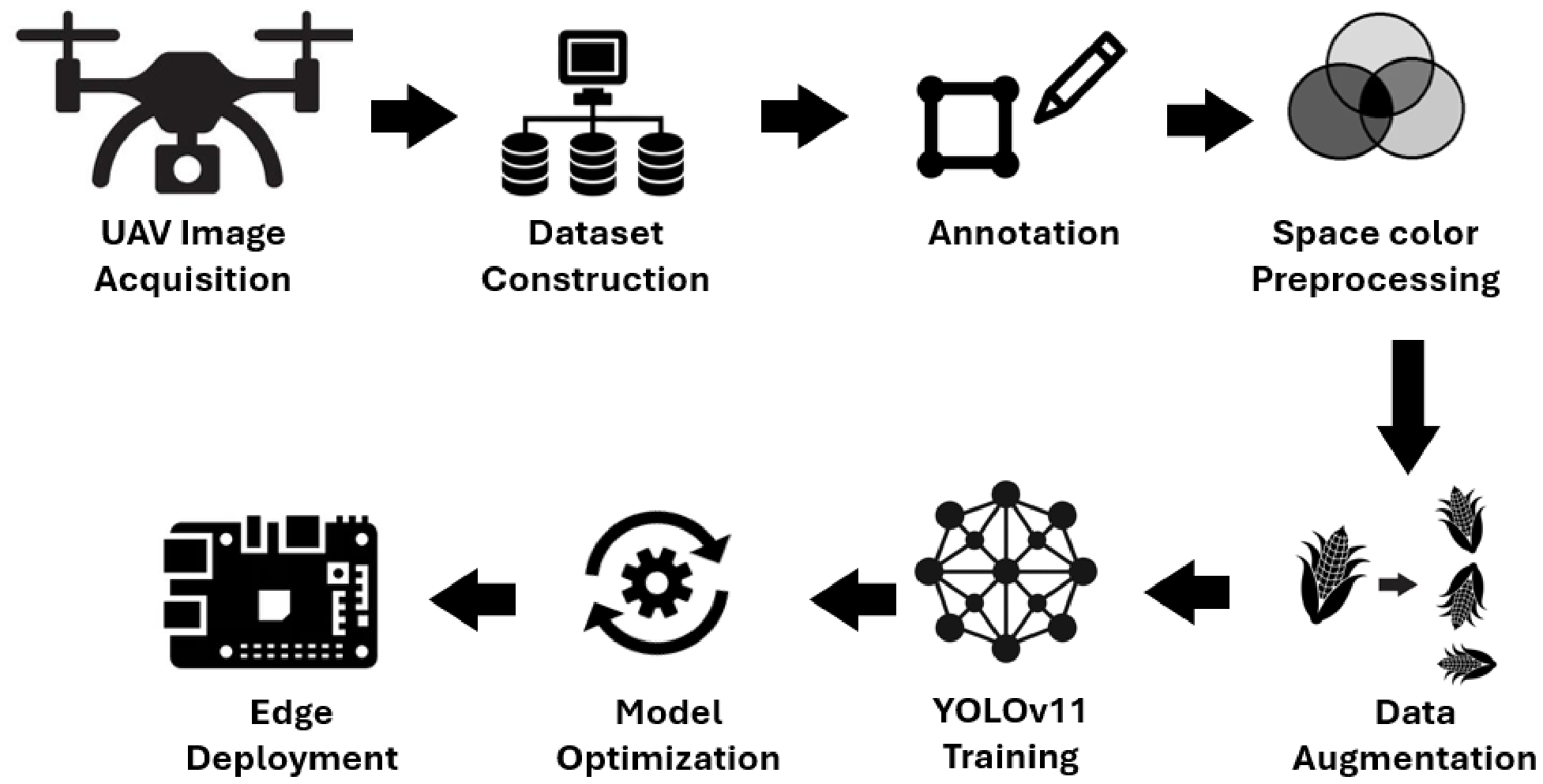
- An end-to-end UAV monitoring pipeline that integrates SAM-assisted annotation, HSV-based preprocessing, YOLOv11 instance segmentation, SAHI tiled inference for large orthomosaics, kernel-density-based spatial aggregation of damage, and edge deployment, all instantiated and evaluated on the same maize/S. frugiperda case study.
- An empirical comparison between multi-class and unified damage representations that quantifies, for the first time in this domain, the robustness gain obtained by collapsing visually similar lesion subclasses (mAP50 of 71.7% for the unified class versus 21–31% for the per-subclass formulation), providing a transferable design recommendation for UAV-based damage detection systems.
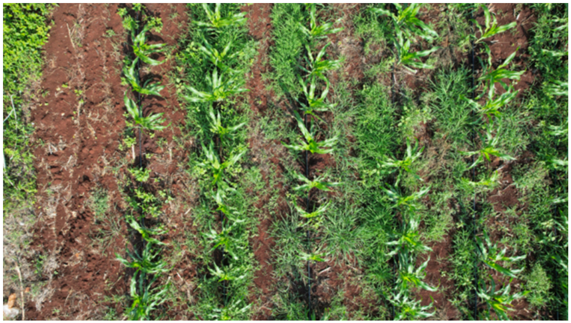
- Region-specific datasets acquired over traditional milpa systems in Yucatán, Mexico, including parcel-level, individual-plant, and infested-plant datasets curated under heterogeneous backgrounds (intercropping, weed presence, exposed soil) that are underrepresented in existing agricultural deep learning benchmarks.
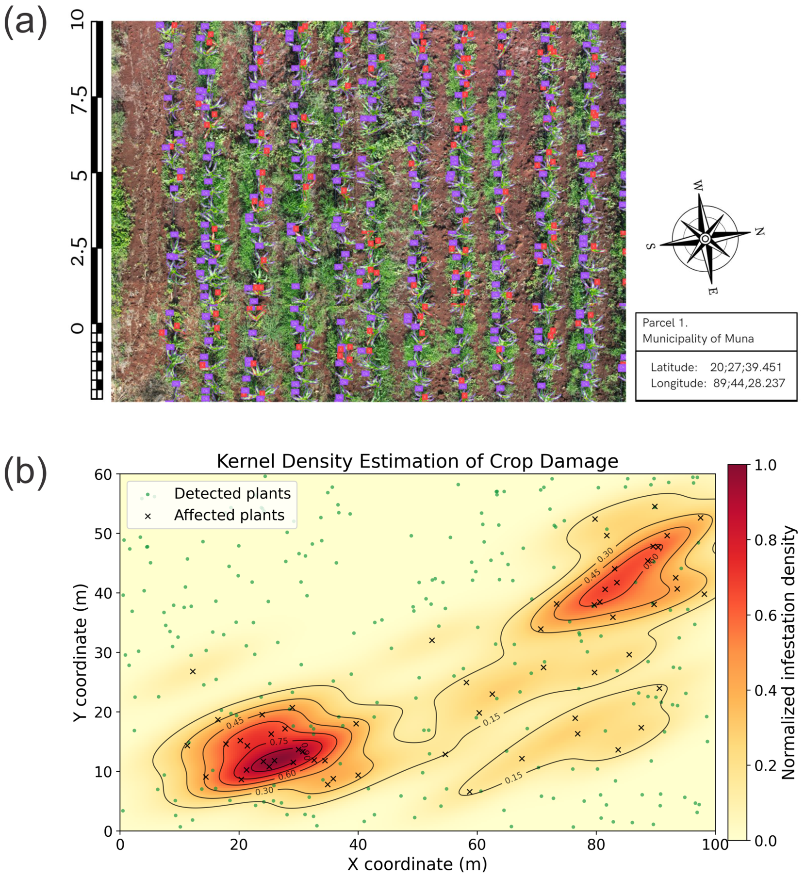
- A georeferenced spatial mapping methodology that converts plant-level detections into parcel-level agronomic indicators (damage rate, damage density, infestation hotspots via kernel density estimation), bridging the gap between object detection outputs and decision support outputs.
- A quantitative feasibility study of edge deployment on a Raspberry Pi 4 using the NCNN inference framework (≈1.3 FPS), providing concrete evidence regarding the operational limits of low-cost on-device monitoring for smallholder farming contexts.
2. Materials and Methods
2.1. Study Area and Field Campaigns
2.2. Aerial Image Acquisition
2.3. Methodological Improvements in the 2024 Campaign
2.4. Hierarchical Dataset Construction and Experimental Roles
2.4.1. Dataset Split
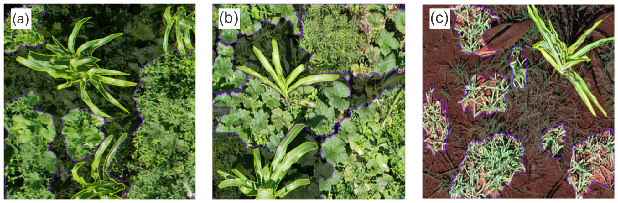
2.4.2. Annotation Process
- Maize plants;
- Non-maize vegetation.
2.5. Image Preprocessing
2.6. Data Augmentation
- Rotations of 90°, 180°, and 270°;
- Horizontal and vertical flips;
- Saturation variations up to ;
- Brightness variations up to .
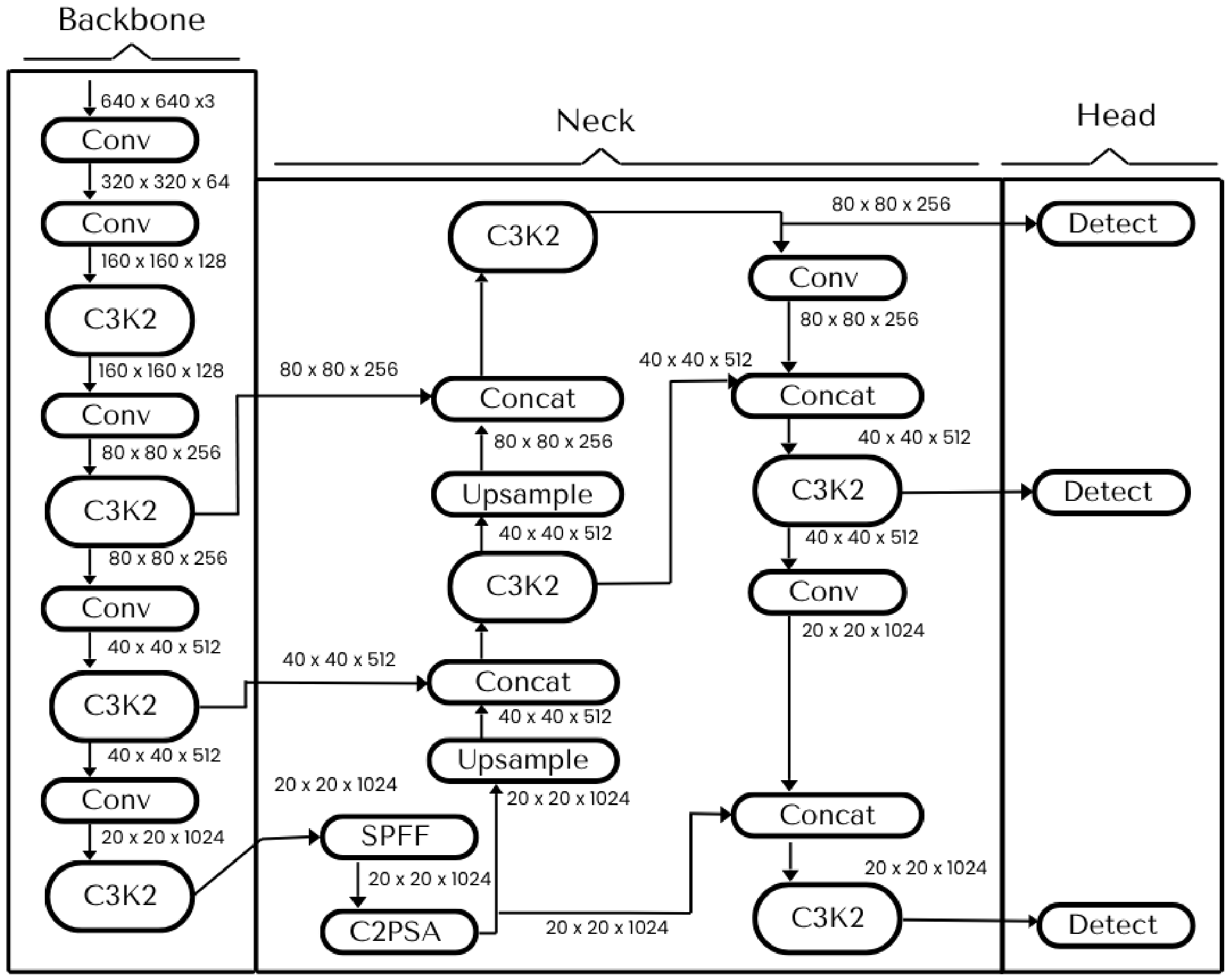
2.7. Model Training
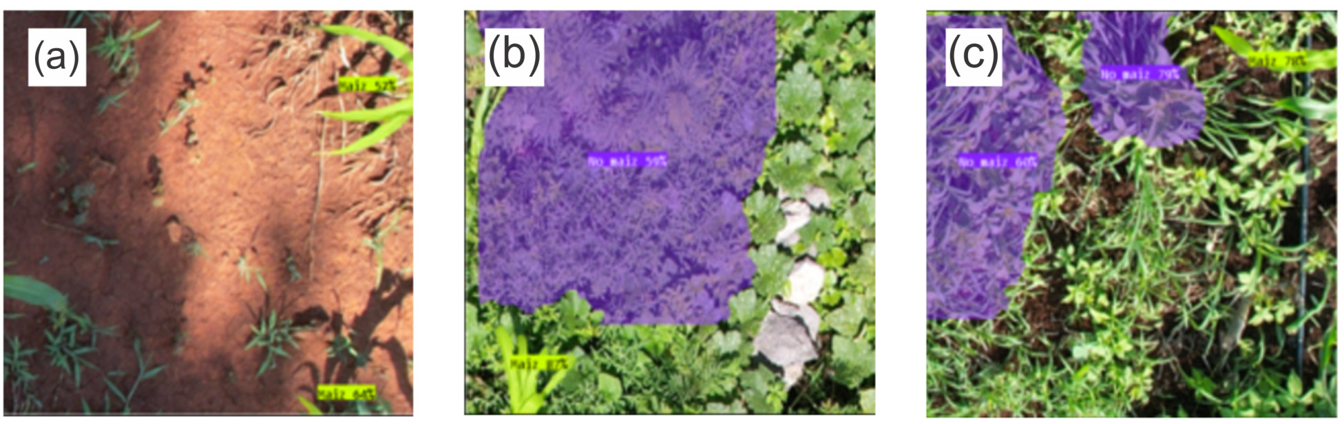
- Model PS1 (Plant Segmentation): Distinguishes maize plants from secondary vegetation.
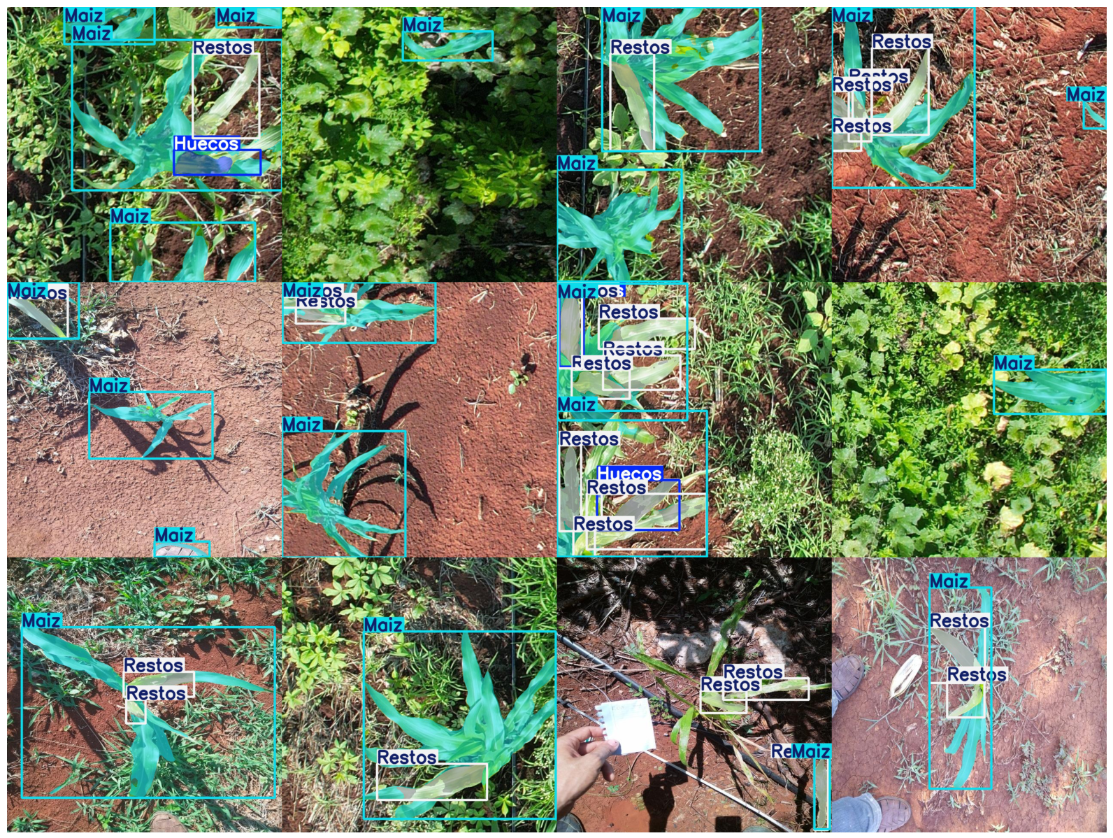
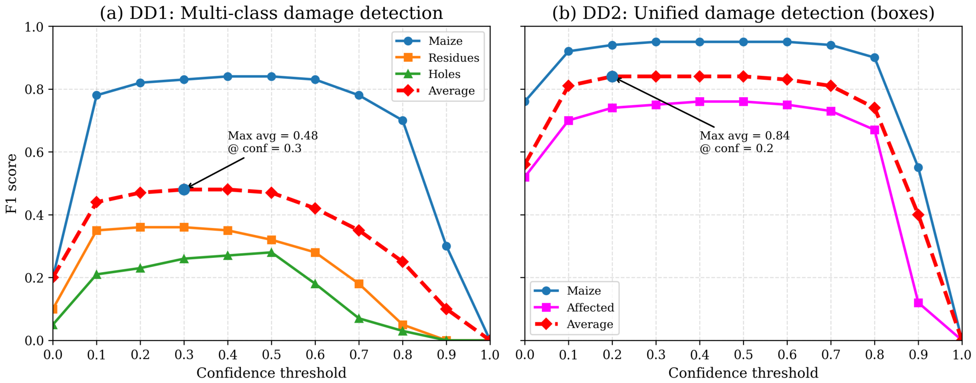
- Model DD1 (Damage Classification): Separates two types of feeding damage: leaf perforations and frass deposits.
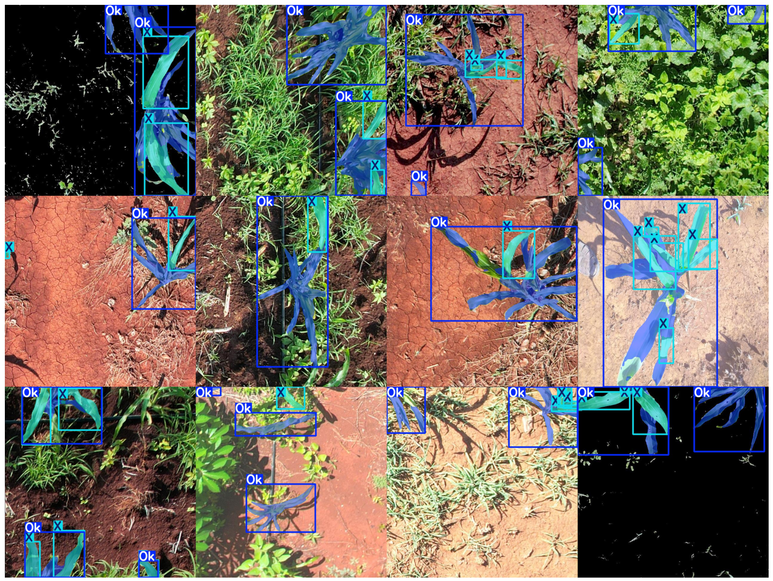
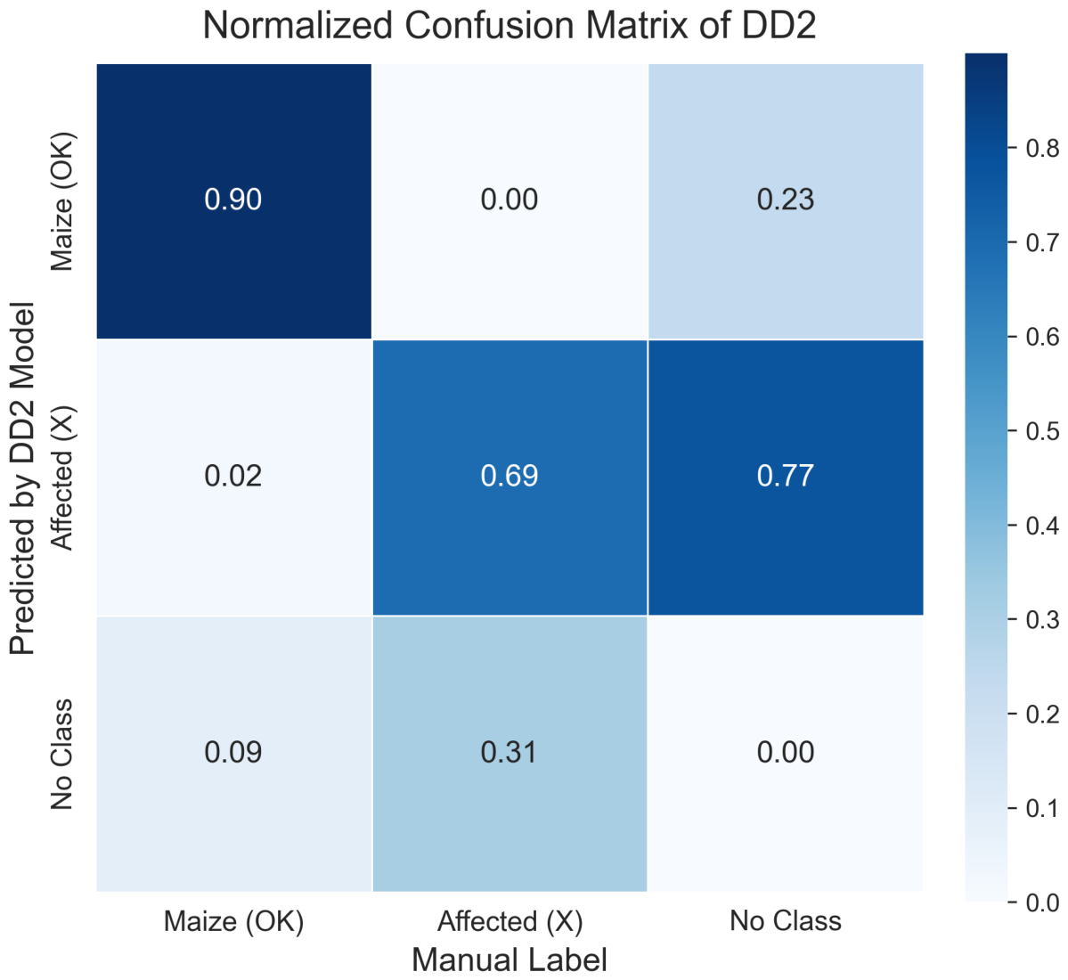
- Model DD2 (Unified Damage Model): Combines all damage manifestations into a single class labeled Affected. This model was adopted as the final configuration after observing that overlapping damage patterns reduced the robustness of the multiclass approach.
2.8. Evaluation Metrics
- mAP50: Average Precision computed at an IoU threshold of 0.5.
- mAP50-95: Average Precision averaged over IoU thresholds from 0.50 to 0.95 with increments of 0.05 following the COCO evaluation protocol [22].
2.9. Spatial Damage Mapping and Infestation Metrics
2.10. Edge Deployment
3. Results
3.1. Plant Segmentation Performance: Model PS1
3.2. Multi-Class Damage Detection: Model DD1
3.3. Unified Damage Detection: Model DD2
3.4. Confusion Matrix and Detection Behavior
3.5. Spatial Mapping of Crop Damage
3.6. Feasibility Analysis of Edge Deployment
4. Discussion
5. Conclusions
Author Contributions
Funding
Institutional Review Board Statement
Informed Consent Statement
Data Availability Statement
Acknowledgments
Conflicts of Interest
Abbreviations
| UAV | Unmanned Aerial Vehicle |
| CNN | Convolutional Neural Network |
| IoU | Intersection over Union |
| mAP | Mean Average Precision |
| RGB | Red–Green–Blue |
| SAHI | Slicing-Aided Hyper Inference |
| FPS | Frames Per Second |
| KDE | Kernel Density Estimation |
| PS1 | Plant Segmentation Model 1 |
| DD1 | Damage Detection Model 1 (Multi-class) |
| DD2 | Damage Detection Model 2 (Unified Damage) |
References
- Yang, C. Remote Sensing and Precision Agriculture Technologies for Crop Disease Detection and Management with a Practical Application Example. Engineering 2020, 6, 528–532. [Google Scholar] [CrossRef]
- Wu, B.; Zhang, M.; Zeng, H.; Tian, F.; Potgieter, A.B.; Qin, X.; Yan, N.; Chang, S.; Zhao, Y.; Dong, Q.; et al. Challenges and opportunities in remote sensing-based crop monitoring: A review. Natl. Sci. Rev. 2023, 10, nwac290. [Google Scholar] [CrossRef] [PubMed]
- Velusamy, P.; Rajendran, S.; Mahendran, R.K.; Naseer, S.; Shafiq, M.; Choi, J.G. Unmanned Aerial Vehicles (UAV) in Precision Agriculture: Applications and Challenges. Energies 2022, 15, 217. [Google Scholar] [CrossRef]
- Osco, L.P.; Marcato Junior, J.; Marques Ramos, A.P.; de Castro Jorge, L.A.; Fatholahi, S.N.; de Andrade Silva, J.; Matsubara, E.T.; Pistori, H.; Gonçalves, W.N.; Li, J. A review on deep learning in UAV remote sensing. Int. J. Appl. Earth Obs. Geoinf. 2021, 102, 102456. [Google Scholar] [CrossRef]
- Kouadio, L.; El Jarroudi, M.; Belabess, Z.; Laasli, S.E.; Roni, M.Z.K.; Amine, I.D.I.; Mokhtari, N.; Mokrini, F.; Junk, J.; Lahlali, R. A Review on UAV-Based Applications for Plant Disease Detection and Monitoring. Remote Sens. 2023, 15, 4273. [Google Scholar] [CrossRef]
- Domingues, T.; Brandão, T.; Ferreira, J.C. Machine Learning for Detection and Prediction of Crop Diseases and Pests: A Comprehensive Survey. Agriculture 2022, 12, 1350. [Google Scholar] [CrossRef]
- Khan, A.; Sohail, A.; Zahoora, U.; Qureshi, A.S. A survey of the recent architectures of deep convolutional neural networks. Artif. Intell. Rev. 2020, 53, 5455–5516. [Google Scholar] [CrossRef]
- Dolatabadian, A.; Neik, T.X.; Danilevicz, M.F.; Upadhyaya, S.R.; Batley, J.; Edwards, D. Image-based crop disease detection using machine learning. Plant Pathol. 2025, 74, 18–38. [Google Scholar] [CrossRef]
- Logavitool, G.; Horanont, T.; Thapa, A.; Intarat, K.; Wuttiwong, K.O. Field-scale detection of Bacterial Leaf Blight in rice based on UAV multispectral imaging and deep learning frameworks. PLoS ONE 2025, 20, e0314535. [Google Scholar] [CrossRef]
- Martins, J.A.C.; Hisano Higuti, A.Y.; Pellegrin, A.O.; Juliano, R.S.; de Araujo, A.M.; Pellegrin, L.A.; Liesenberg, V.; Ramos, A.P.M.; Goncalves, W.N.; Sant’Ana, D.A.; et al. Assessment of UAV-Based Deep Learning for Corn Crop Analysis in Midwest Brazil. Agriculture 2024, 14, 2029. [Google Scholar] [CrossRef]
- Lu, C.; Nnadozie, E.; Camenzind, M.P.; Hu, Y.; Yu, K. Maize plant detection using UAV-based RGB imaging and YOLOv5. Front. Plant Sci. 2024, 14, 1274813. [Google Scholar] [CrossRef] [PubMed]
- Hamzenejadi, M.H.; Mohseni, H. Fine-tuned YOLOv5 for real-time vehicle detection in UAV imagery: Architectural improvements and performance boost. Expert Syst. Appl. 2023, 231, 120845. [Google Scholar] [CrossRef]
- Zhao, M.; Wang, D.; Yan, Q.; Li, Z.; Liu, X. UAV-Multispectral Based Maize Lodging Stress Assessment with Machine and Deep Learning Methods. Agriculture 2025, 15, 36. [Google Scholar] [CrossRef]
- Miri Rekavandi, A.; Rashidi, S.; Boussaid, F.; Hoefs, S.; Akbas, E.; Bennamoun, M. Transformers in Small Object Detection: A Benchmark and Survey of State-of-the-Art. ACM Comput. Surv. 2025, 58, 64. [Google Scholar] [CrossRef]
- Ahmed, W.A.; Yan, D.; Hamed, J.O.; Olatoyinbo, S.F. Advances in UAV-based deep learning for cassava disease monitoring and detection: A comprehensive review of models, imaging techniques, and agricultural applications. Smart Agric. Technol. 2025, 12, 101400. [Google Scholar] [CrossRef]
- Chen, J.; Fu, Y.; Guo, Y.; Xu, Y.; Zhang, X.; Hao, F. An improved deep learning approach for detection of maize tassels using UAV-based RGB images. Int. J. Appl. Earth Obs. Geoinf. 2024, 130, 103922. [Google Scholar] [CrossRef]
- Dobosz, B.; Gozdowski, D.; Koronczok, J.; Žukovskis, J.; Wójcik-Gront, E. Detection of Crop Damage in Maize Using Red–Green–Blue Imagery and LiDAR Data Acquired Using an Unmanned Aerial Vehicle. Agronomy 2025, 15, 238. [Google Scholar] [CrossRef]
- Feng, J.; Sun, Y.; Zhang, K.; Zhao, Y.; Ren, Y.; Chen, Y.; Zhuang, H.; Chen, S. Autonomous Detection of Spodoptera frugiperda by Feeding Symptoms Directly from UAV RGB Imagery. Appl. Sci. 2022, 12, 2592. [Google Scholar] [CrossRef]
- Carion, N.; Massa, F.; Synnaeve, G.; Usunier, N.; Kirillov, A.; Zagoruyko, S. End-to-End Object Detection with Transformers. In Proceedings of the Computer Vision—ECCV 2020; Vedaldi, A., Bischof, H., Brox, T., Frahm, J.M., Eds.; Springer: Cham, Switzerland, 2020; pp. 213–229. [Google Scholar] [CrossRef]
- Zhao, Y.; Lv, W.; Xu, S.; Wei, J.; Wang, G.; Dang, Q.; Liu, Y.; Chen, J. Detrs beat yolos on real-time object detection. In Proceedings of the IEEE/CVF Conference on Computer Vision and Pattern Recognition, Seattle, WA, USA, 16–22 June 2024; pp. 16965–16974. [Google Scholar] [CrossRef]
- Zhou, Y.; Wei, Y. UAV-DETR: An Enhanced RT-DETR Architecture for Efficient Small Object Detection in UAV Imagery. Sensors 2025, 25, 4582. [Google Scholar] [CrossRef]
- Lin, T.Y.; Maire, M.; Belongie, S.; Hays, J.; Perona, P.; Ramanan, D.; Dollár, P.; Zitnick, C.L. Microsoft COCO: Common Objects in Context. In Proceedings of the Computer Vision—ECCV 2014; Fleet, D., Pajdla, T., Schiele, B., Tuytelaars, T., Eds.; Springer: Cham, Switzerland, 2014; pp. 740–755. [Google Scholar] [CrossRef]
- Zhang, K.; Zhang, R.; Yang, Z.; Deng, J.; Abdullah, A.; Zhou, C.; Lv, X.; Wang, R.; Ma, Z. Efficient Wheat Lodging Detection Using UAV Remote Sensing Images and an Innovative Multi-Branch Classification Framework. Remote Sens. 2023, 15, 4572. [Google Scholar] [CrossRef]
- Aszkowski, P.; Kraft, M.; Drapikowski, P.; Pieczyński, D. Estimation of corn crop damage caused by wildlife in UAV images. Precis. Agric. 2024, 25, 2505–2530. [Google Scholar] [CrossRef]
- Khujamatov, H.; Muksimova, S.; Abdullaev, M.; Cho, J.; Jeon, H.S. Advanced Insect Detection Network for UAV-Based Biodiversity Monitoring. Remote Sens. 2025, 17, 962. [Google Scholar] [CrossRef]
- Bai, Z.; Ji, L.; Tang, H.; Qiu, J.; Kang, S.; Liu, C.; Bian, Z. Rapid Detection and Segmentation of Landslide Hazards in Loess Tableland Areas Using Deep Learning: A Case Study of the 2023 Jishishan Ms 6.2 Earthquake in Gansu, China. Remote Sens. 2025, 17, 2667. [Google Scholar] [CrossRef]
- Manoj, H.M.; Shanthi, D.L.; Lakshmi, B.N.; Archana, K.J.; Venkata Naga Jyothi, E.; Archana, K. AI-driven drone technology and computer vision for early detection of crop disease in large agricultural areas. Sci. Rep. 2026, 16, 2479. [Google Scholar] [CrossRef]
- Radočaj, D.; Radočaj, P.; Plaščak, I.; Jurišić, M. Evolution of Deep Learning Approaches in UAV-Based Crop Leaf Disease Detection: A Web of Science Review. Appl. Sci. 2025, 15, 778. [Google Scholar] [CrossRef]
- Zhu, H.; Lin, C.; Liu, G.; Wang, D.; Qin, S.; Li, A.; Xu, J.L.; He, Y. Intelligent agriculture: Deep learning in UAV-based remote sensing imagery for crop diseases and pests detection. Front. Plant Sci. 2024, 15, 1435016. [Google Scholar] [CrossRef]
- Liu, Y.; Liang, X.; Wu, C.; An, X.; Wu, M.; Zhao, Z.; Li, Z.; Chen, Q. Optimization of spray operation parameters of unmanned aerial vehicle confers adequate levels of control of fall armyworm (Spodoptera frugiperda). Front. Plant Sci. 2025, 16, 1581367. [Google Scholar] [CrossRef]
- Reyna-Bowen, J.L.; Murillo, L.; Cedeño, H.; Vera Montenegro, L.; Delgado-Moreira, M.I.; Velásquez Cedeño, S. Optimizing the Flight Altitude of the Agras T40 Drone for Controlling Spodoptera frugiperda in Maize (Zea mays L.) Plantations. Agroindustrial Sci. 2025, 15, 355–361. [Google Scholar] [CrossRef]




| Dataset | Images | Resolution | Purpose |
|---|---|---|---|
| Environmental Context Dataset | ∼100 | Field-scale contextual variability | |
| Instance Segmentation Training Dataset | 668 | PS1 model training | |
| Diagnostic Damage Dataset | 707 | variable | DD1/DD2 model training |
| Test Dataset | 199 | variable | Independent evaluation |
| Class | Images | Instances | Precision | Recall | mAP50 | mAP50–95 |
|---|---|---|---|---|---|---|
| Overall | 148 | 571 | 0.450 | 0.443 | 0.474 | 0.325 |
| Maize | 148 | 281 | 0.774 | 0.890 | 0.898 | 0.673 |
| Residues | 148 | 231 | 0.440 | 0.370 | 0.314 | 0.192 |
| Holes | 148 | 59 | 0.136 | 0.068 | 0.211 | 0.109 |
| Class | Images | Instances | Precision | Recall | mAP50 | mAP50–95 |
|---|---|---|---|---|---|---|
| Overall | 199 | 979 | 0.860 | 0.775 | 0.830 | 0.685 |
| Maize | 199 | 435 | 0.929 | 0.900 | 0.942 | 0.814 |
| Affected | 199 | 544 | 0.792 | 0.650 | 0.717 | 0.556 |
| Class | Images | Instances | Precision | Recall | mAP50 | mAP50–95 |
|---|---|---|---|---|---|---|
| Overall | 199 | 979 | 0.804 | 0.714 | 0.733 | 0.436 |
| Maize | 199 | 435 | 0.828 | 0.784 | 0.777 | 0.391 |
| Affected | 199 | 544 | 0.781 | 0.643 | 0.700 | 0.481 |
| Study | Crop | Sensor Type | Method | Reported Performance |
|---|---|---|---|---|
| Feng et al. (2022) [18] | Maize | RGB UAV | CNN patch classification (ResNeSt50) | 89.4% accuracy (patch-level) |
| Zhang et al. (2023) [23] | Wheat | RGB UAV | CNN (Deeplabv3+) | Accuracy ∼ 90% |
| Lu et al. (2024) [11] | Maize | RGB UAV | YOLOv5 plant detection | mAP50 > 0.85 (plant-level) |
| Chen et al. (2024) [16] | Maize | RGB UAV | RESAM-YOLOv8n (tassel detection) | mAP50 = 95.7% |
| Martins et al. (2024) [10] | Maize | RGB UAV | Semantic segmentation (SegFormer) | mIoU > 0.81 |
| Dobosz et al. (2025) [17] | Maize | RGB + LiDAR UAV | DL segmentation + DSM analysis | 92.9% accuracy (RGB DL) |
| This study | Maize | RGB UAV | YOLO-based segmentation | Competitive mAP50 performance |
Disclaimer/Publisher’s Note: The statements, opinions and data contained in all publications are solely those of the individual author(s) and contributor(s) and not of MDPI and/or the editor(s). MDPI and/or the editor(s) disclaim responsibility for any injury to people or property resulting from any ideas, methods, instructions or products referred to in the content. |
© 2026 by the authors. Licensee MDPI, Basel, Switzerland. This article is an open access article distributed under the terms and conditions of the Creative Commons Attribution (CC BY) license.
Share and Cite
Carrillo-Gómez, A.; Moctezuma, D.; Camacho-Pérez, E. An Automated Information Processing Framework for UAV-Based Detection and Spatial Mapping of Crop Damage Using Deep Learning. Information 2026, 17, 529. https://doi.org/10.3390/info17060529
Carrillo-Gómez A, Moctezuma D, Camacho-Pérez E. An Automated Information Processing Framework for UAV-Based Detection and Spatial Mapping of Crop Damage Using Deep Learning. Information. 2026; 17(6):529. https://doi.org/10.3390/info17060529
Chicago/Turabian StyleCarrillo-Gómez, Alejandro, Daniela Moctezuma, and Enrique Camacho-Pérez. 2026. "An Automated Information Processing Framework for UAV-Based Detection and Spatial Mapping of Crop Damage Using Deep Learning" Information 17, no. 6: 529. https://doi.org/10.3390/info17060529
APA StyleCarrillo-Gómez, A., Moctezuma, D., & Camacho-Pérez, E. (2026). An Automated Information Processing Framework for UAV-Based Detection and Spatial Mapping of Crop Damage Using Deep Learning. Information, 17(6), 529. https://doi.org/10.3390/info17060529