Article

Influence of Sea Surface Current on Wave Height Inversion in Shadow Statistical Method

1
College of Physical and Electronic Information, Luoyang Normal University, No. 6 Jiqing Road, Luoyang 471934, China
2
College of Intelligent Systems Science and Engineering, Harbin Engineering University, No. 145 Nantong Street, Harbin 150001, China
*
Author to whom correspondence should be addressed.
Information 2021, 12(8), 303; https://doi.org/10.3390/info12080303
Submission received: 14 June 2021 / Revised: 17 July 2021 / Accepted: 26 July 2021 / Published: 29 July 2021
(This article belongs to the Section Information Processes)

Abstract

:
Currently, the research on the inversion of wave height by using the shadow statistical method attracts more attention, due to the benefit of without external calibration equipment. Under the assumption of the sea wave satisfying the ideal first-order dispersion relation, the wave period is used to describe the relationship between wave slope and significant wave height. However, the influence of the sea surface current is ignored during the process of extracting the wave height, since the ideal first-order dispersion relation is adopted. By deeply investigating the theoretical derivation process, the retrieving accuracy of wave height is deteriorated when the surface current exists. To solve this problem of the shadow statistical method, the influence of the surface current on the wave height inversion is investigated and is considered in the first-order dispersion relation for retrieving significant wave height in this paper. The synthetic and the collected X-band marine radar images are utilized to certify the influence of sea surface current on the inversion of the significant wave height. The experimental results demonstrate that the inversion accuracy of the significant wave height can be improved when the influence of the surface current is taken into account.

1. Introduction

Waves are an important component of ocean physics. In the process of ocean exploitation, understanding the evolution law of the ocean environment is required. With the rapid development of ocean remote sensing technology, using X-band marine radar to measure and monitor the ocean wave of the large area in real-time is a research hotspot in recent years [1,2,3]. Commonly, the collected radar images are used to extract hydrological parameters, such as sea surface current, significant wave height, bathymetry, which are vitally important for the safety of the port and maritime operation [4,5,6].
The significant wave height is the key technical indicator for studying the wave field and is an important parameter to characterize the wave energy. Thus, it has very important scientific research value and military significance to survey the wave height [7]. This makes surveillance of wave height have very important scientific research value and military significance [7]. Currently, the main methods of extracting significant wave height from X-band radar image are spectrum analysis method based on 3D fast Fourier transform (3DFFT) and shadow statistical method by using the shadowing in the radar image. The 3DFFT method for retrieving the wave information is to achieve the wavenumber frequency spectrum from the radar image sequence. Then, the noise is filtered out based on the dispersion band-pass filter. The modulation transfer function is utilized to transform the image spectrum into wave spectrum and the signal-to-noise ratio (SNR) of the sea wave can be obtained from the wave spectrum [8,9]. Thus, the significant wave height is determined from the marine radar images by utilizing the linear relationship between the square root of the SNR and the significant wave height. To satisfy the requirement of accuracy, both the external equipment in situ and plenty of effective observation data are demanded to determine the parameters of the linear relationship.
Compared to the traditional 3DFFT method, the shadow statistical method has the advantage of without external reference calibration for extracting wave height from the X-band marine radar images. Although the radar gray image contains various physical modulation, the principle of the shadow statistical method for retrieving the significant wave height is based on the dominant shadow characteristic. It is found that local shadow plays a leading role in shadow modulation of sea clutter image, which establishes the theoretical support for wave height inversion based on the shadow image [10]. By using the shadow statistical characteristic of the marine radar image, a novel method for extracting the significant wave height is proposed in [11]. The shadow statistical method benefits without external equipment for calibration. Under deep water conditions, the dependence of backscatter echo intensity of sea wave on the range and azimuth is investigated [12]. The experimental results demonstrate that the proposed method has good performance for retrieving wave height from the collected radar image with high wind speed. However, the wave height is overestimated under the condition of less wind. The echo intensity of a marine radar image in azimuth is closely related to the angle between the illumination direction of the electromagnetic wave and the wind direction [13,14]. The normalized radar backscatter cross section (NRCS) is largest when the wind direction is against the radar observation direction. The NRCS is smallest when the wind direction is perpendicular to the radar observation direction.
To improve the performance of the shadow statistical method, the analysis area near the upwind direction is selected from the acquired radar image, and the shadow segmentation threshold is determined by smoothing the image histogram [15,16]. The experimental results illuminate that the retrieving accuracy of the significant wave high is improved. However, the extracted wave height is still overestimated under low wind speed and is underestimated under rain conditions. By studying the sea surface slope formula for calculating significant wave height in the shadow statistical method, it is found that the formula is deduced under the assumption of infinite water-depth and the influence of surface current is not considered in the process of derivation. Thus, the influence of the water-depth on the inversion accuracy is considered [17]. The improved inversion formula of wave height is suitable for both shallow water and deep water conditions. The surface current affects the calculation of the significant wave height, especially in the strong surface current area [18,19]. The interaction between ocean wave and surface current can cause the significant change of the wave height. Considering the effects of water depth and the surface current on the dispersion relationship, both water depth and sea surface currents are simultaneously estimated for shallow water areas from the collected X-band marine radar image [20]. Based on the proposed strategy of quality control and data analysis procedures, the retrieving accuracy of bathymetric maps from the X-band radar image is improved in the nearshore area [21]. By maximizing the correlation coefficient between the reconstructed sea wave surface elevation and the non-shadow radar image, a new method for retrieving wave height without external reference equipment is proposed in [22].
An ensemble empirical mode decomposition scheme is used to retrieve wave height from the radar image in the distance direction. The simulation demonstrates that the proposed method can improve the retrieving accuracy compared to the 3DFFT and shadowing statistical methods [23]. By using the deviation of the kurtosis between the Weibull distribution and the echo intensity of radar images, a novel method for extracting wave height under a low sea state is developed [24]. Based on the convolutional neural network technology and the extracted multiscale spatial features from radar images, a novel method for estimating significant wave height is illuminated and the inversion accuracy of wave height is improved [25]. To solve the problem that the correlation between SNR and the significant wave height is poor for the nononshore wind case, a method based on an artificial neural network is proposed to estimate wave height [26].
Although the shadow statistical method could retrieve significant wave height from the acquired X-band marine radar image without external reference, the research on investigating the influence of the surface current on retrieving wave height is rare. Therefore, the influence of the sea surface current on retrieving significant wave height is carried out in this paper.
The structure of this paper is as follows: Section 2 presents the fundamental principle and the implementation process of the wave height inversion from the X-band marine radar images based on the shadow statistical method. The theoretical analysis of the effect of sea surface current on wave height inversion is investigated in Section 3. The synthetic and the acquired marine radar images are utilized to test the influence of the surface current on the wave height inversion in Section 4. Finally, the conclusions are summarized in Section 5.

2. Basic Principle of Calculating Wave Height by Using the Shadow Statistical Method

The roughness of the sea surface increases with the increase in wind speed. When the electromagnetic beam of X-band radar is incident to the rough sea surface, the backscatter echo is formed [27]. Meanwhile, the Bragg scattering is generated by the micro-scale wave which is superimposed on a longer gravity wave and co-modulated. Thus, it provides the conditions for forming the shadow area. Under the combined effect of various modulation, the radar echo intensity changes with the change of the distance to the radar antenna and is indicated by the bright and dark stripes.
The flowchart for retrieving significant wave height based on the shadow statistical method from X-band marine radar images is shown in Figure 1. To retrieve the significant wave height based on the shadow statistical method, firstly, the selected analysis area is required to be preprocessed. Then, the threshold of shadow segmentation is estimated to separate the shadow image into the shadow area and the non-shadow area. By computing the shadow ratio of the selected analysis area, the sea surface slope can be achieved based on the Smith fitting function. Thus, the wave height can be obtained by using the relation between the significant wave height and the sea surface slope.

2.1. The Estimation of the Shadow Segmentation Threshold

Edge images are obtained by convolving the original radar image with pixel difference operators in adjacent eight directions [11,15]. The convolution operation formula based on the different operator in the neighborhood of the radar image is as follows:
I E i ( r , θ ) = I ( r , θ ) H i ( r , θ )
where ⊗ denotes the convolution operation, I ( r , θ ) is the original radar image, H i ( r , θ ) is the pixel difference operator, i { 1 , 2 , , 8 } , I E i ( r , θ ) is the edge image, r and θ are the distance and the azimuth, respectively. The edge value of the upper N-percentile of the edge pixel is selected as the threshold value of the edge gradient image. Then, the edge image is obtained after thresholding, which is given by
I T i ( r , θ ) = 1 , I E i ( r , θ ) > upper N - percentile 0 , otherwise
By superimposing the edge images extracted in different directions, we have
I T ( r , θ ) = i = 1 8 I T i ( r , θ )
The isolated noise point is removed by comparing each point in the complete edge image I T with the threshold [11,15]. The pixel value η of the radar image at the corresponding non-zero position of the complete edge image can be determined. Then, the histogram function F H ( η ) is obtained. Thus, the shadow segmentation threshold τ S can be achieved and is shown below [11,15]
τ S = mode ( F H ( η ) )
where mode ( · ) is the mode function.

2.2. The Illumination Ratio of the Radar Image

The original radar image I ( r , θ ) is divided into the shadow area and the non-shadow area by using the obtained gray-scale threshold τ S . After obtaining the shadow threshold, the shadow image I S ( r , θ ) can be achieved, which is given by [11,15]
I S ( r , θ ) = 1 , I ( r , θ ) < τ S 0 , otherwise
The shadow ratio of the radar image which is a function of relating to the grazing angle could be calculated by using the obtained shadow image. The shadow image is divided into sectors in azimuth, and the shadow image is divided into blocks in radial direction.

2.3. The Estimation of the Sea Wave Surface Slope

According to the Smith function, the illumination probability that a point on the Gaussian surface is not in the shadow area is written as [11]
L ( γ ) = 1 0.5 erfc ( μ / 2 σ R M S ) Λ ( μ ) + 1
where
Λ ( μ ) = 2 / π · σ R M S / μ · e μ 2 / 2 σ R M S 2 erfc ( μ / 2 σ R M S ) 2
and
μ = tan ( γ )
σ R M S is the RMS sea surface slope, and erfc ( · ) is the co-error function. According to the relation between illumination probability in geometric shadowing of random rough surface and shadow ratio function, we have
S ( γ ) = 1 L ( γ )
where γ is the grazing angle, L is the illumination probability. The shadow ratio function S ( γ ) can be obtained by calculating the shadow ratio in each block. The Equation (9) associates the shadow ratio with the illumination probability and the RMS surface slope. In this paper, Equation (6) is used as the Smith’s fitting function to estimate the RMS slope σ R M S . The RMS slope in each sector can be estimated by fitting the shadow proportion function in the segmentation region of the edge image. The averaged RMS slope σ is achieved by averaging the estimated slope of each sector in azimuth. Thus, we have
σ = 1 M i = 1 M σ R M S i 2
where σ R M S i is the estimated slope for the i-th sector, M is the total number of sectors divided of the shadow image in azimuth.

2.4. The Estimation of the Significant Wave Height

Based on the relation between the wave slope and the significant wave height, the sea surface slope σ is generally defined as
σ = H λ
where λ is the wavelength, and H is the wave height. Since the wavelength cannot be measured directly, the wave period T = 2 π / ω instead of the wavelength λ = 2 π / k is used. Under the assumption of the sea wave satisfying the ideal first-order dispersion relation and the infinite water-depth, the dispersion relation is described as ω = g k , where ω is the angular frequency. Thus, the wave slope can be expressed as
σ = H λ = H k 2 π = H 2 π ω 2 g = H 2 π g 2 π T 2 = 2 π H g T 2
where k denotes the wavenumber, and g is the gravitational acceleration. For convenience, the ideal dispersion relationship is used to express the wave height. In Equation (12), the influence of surface current on retrieving wave height is ignored. However, the surface current always exists in practice. Based on the Equation (12), the significant wave height is described as [11,15]
H = σ g T 2 2 π

3. Theory Analysis of the Effect of Sea Surface Current on Wave Height Inversion

Based on the derivation in Equation (12), we found that the ideal first-order dispersion relation is adopted and the effect of the sea surface current is not considered. Assuming that the sea surface wave and current fields are homogeneous in spacial domain and stationary in the temporal domain for the selected spatial region, for the linear wave theory, the dispersion relation of the first-order gravity wave is as follows
ω = g | k | + k · u = g | k | + | k | · | u | · cos α
where k = k x , k y , u = u x , u y is the sea surface current, | · | denotes the modules, α represents the angle between the surface current and the wavenumber.
If a movement of sea surface current relative to radar platform exists, the dispersion relation curve is shifted, due to the Doppler frequency shift caused by the relative movement between the radar antenna platform and the sea surface current. Thus, the dispersion relation can be written as
ω = g | k | + k · u c u r
where u c u r is the velocity of the surface current. From Equation (14), it can be observed that the influence of the surface current on the wave height inversion can be negligible, when the current velocity is relatively small. However, the surface current has a great influence on the performance of the wave height inversion, when the velocity is large and the current direction is parallel to the direction of the wavenumber.
The wave peak period and the sea surface current could be extracted from the acquired X-band marine radar image [28,29,30,31]. Thus, the angular frequency ω and the surface current u could be determined. Then, based on the relation in Equation (16), the wavenumber k could be calculated.
ω = g | k | + k x · u x + k y · u y
Hence, the wave height is given by
H = 2 π σ k
where k is the modulus of wavenumber k . When the influence of the sea surface current is considered, the wave height is retrieved by using the wavenumber information instead of the angular frequency.

4. Experimental Results and Analysis

4.1. Synthetic Radar Images and Experiment

Under the same sea conditions, the effect of surface current on retrieving the significant wave height by using the synthetic radar images is investigated in below. To certify the influence of the sea surface current on the wave height inversion, based on the Joint North Sea Wave Project (JoNSWaP) spectrum, the method in [17] is used to generate the simulated sea surface elevation images and polar radar images. To simplify the simulation, the shadow modulation is mainly considered. Meanwhile, the wave period and the surface current is part of the input for simulating radar images in this paper. The simulated radar image is used to obtain sea surface slope. The wave period of the input for generating radar images is directly used to calculate significant wave height.
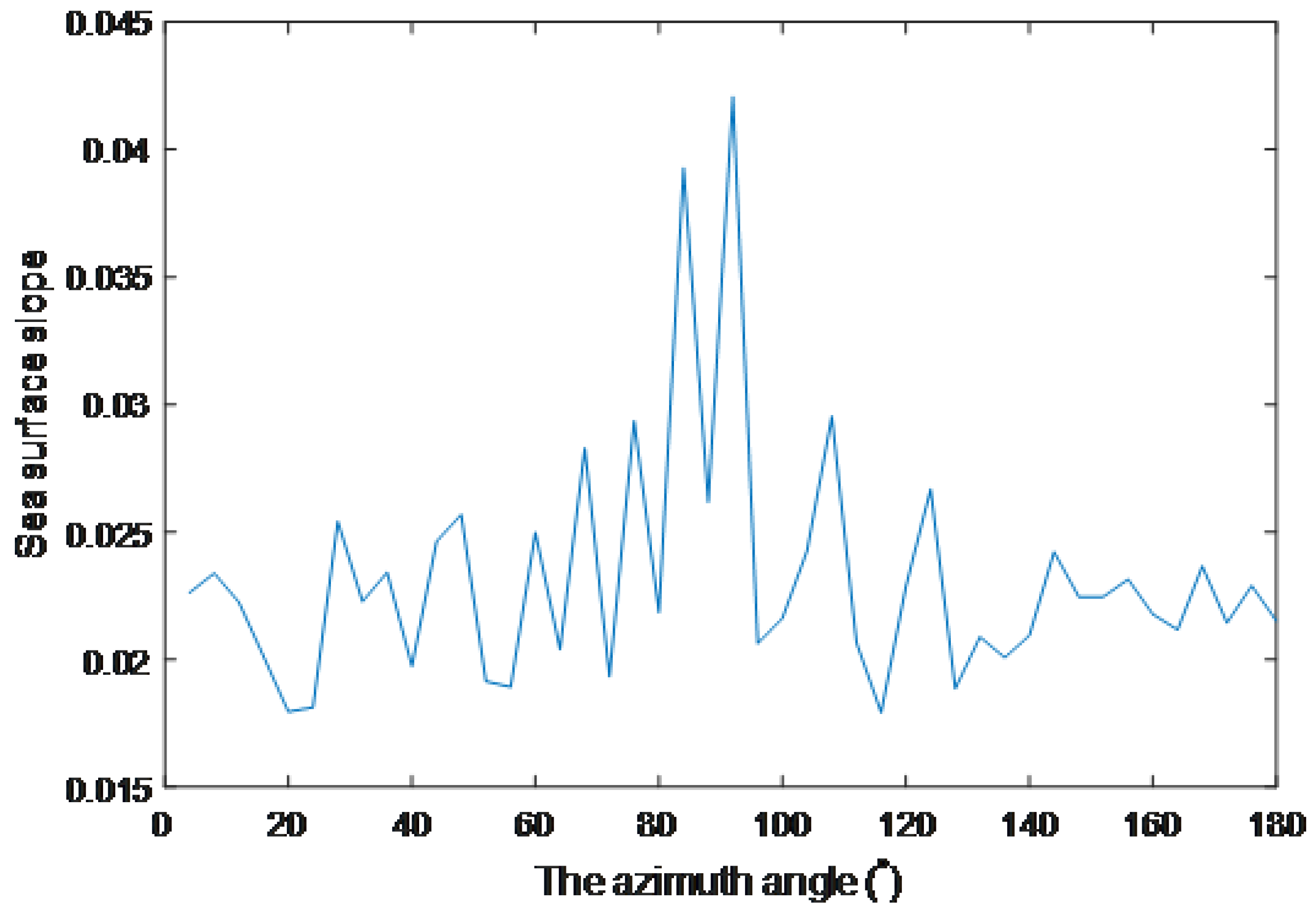
Here, the range resolution of the simulated radar image in distance is 7.5 m and the antenna height is 25 m. The wave parameters with wave peak period 11.03 s, wavelength 190 m, and significant wave height 3.68 m are input to the JoNSWaP spectrum. The simulated marine radar image without surface current is shown in Figure 2. The horizontal axis denotes the angle in azimuth and the vertical axis denotes the distance from the illuminated area to the radar antenna. Based on the wave height inversion principle of the shadow statistical method, the probability of bright area and the wave surface slope of the simulated radar image can be calculated. The obtained shadow image from the original image simulated is divided into the partition with 20° intervals in the azimuthal direction. The estimated sea wave slope in azimuth is presented in Figure 3. Meanwhile, the wave peak period and the surface current are utilized to calculated wavenumber k based on the Equation (16). Then, by using the relation in Equation (16), the significant wave height can be achieved.
To analyze the influence of the sea surface current on the inversion of wave height, the simulated radar image is used. Meanwhile, the angle between the current direction and the wave direction is set to zero, in order to simplify the analysis. The reference wave height is about 3.63 m and the wavelength is still 190 m. Based on the inversion steps of the wave height by using the shadow statistical method, the significant wave height can be obtained.
In order to investigate the influence of surface current on the shadow statistical method, the different surface current is, respectively, introduced to simulate radar images. Based on the proposed scheme in this paper, the influence of the surface current is considered in the dispersion relation in Equation (14). Under different surface current conditions, the simulated radar image is used to calculate the wave height. Based on the traditional method and the proposed method in this paper, the retrieved significant wave height is presented in Table 1.
From Table 1, it can be observed that the surface slope of the simulated radar image increases with the increase in the sea surface current. For the fixed wavelength, the wave peak period decreases based on the first-order dispersion relation. Meanwhile, the retrieved significant wave height which ignores or considers the effect of the surface current is described in Table 1.
By comparing the retrieved wave height with the reference value, it can be found that the achieved wave height when the influence of the surface current is considered is more close to the reference value than that which ignores the influence of surface current. Moreover, the error of the wave height retrieved increases with the increase in the surface current when the surface current direction is parallel to the wave direction.

4.2. Shore-Based Radar Images and Experiment

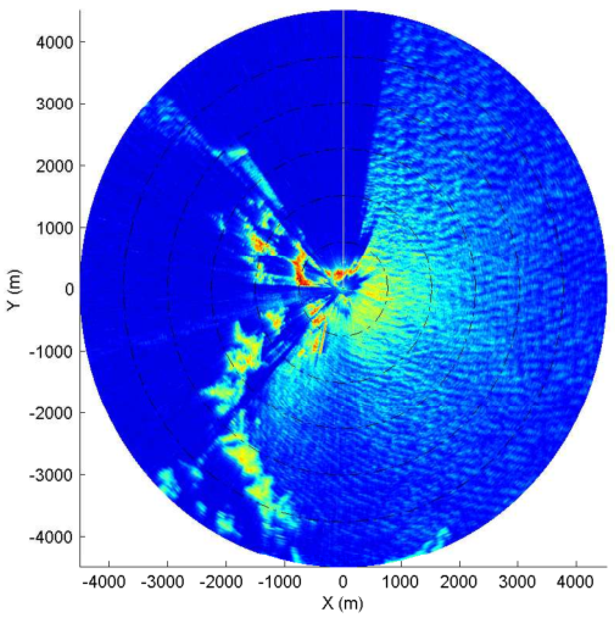
The collected X-band marine radar images on 17 November 2014 07:56 is used to test the influence of surface current on the inversion accuracy of wave height. The detailed configuration parameters of the marine radar is illuminated in Table 2. The radar antenna scans imaging and the radar works on short pulse mode. The X-band marine radar image commonly contains abundant sea clutter information. The radar image collected during the experiment is given in Figure 4. The installation height of the antenna is about 45 m. The range resolution of the radar image in distance direction is 7.5 m. The echo intensity of the radar image acquired decays with the increase in distance from the illumination area to the radar antenna. In the right part of the collected radar image, the bright and dark stripes forms the sea clutter.
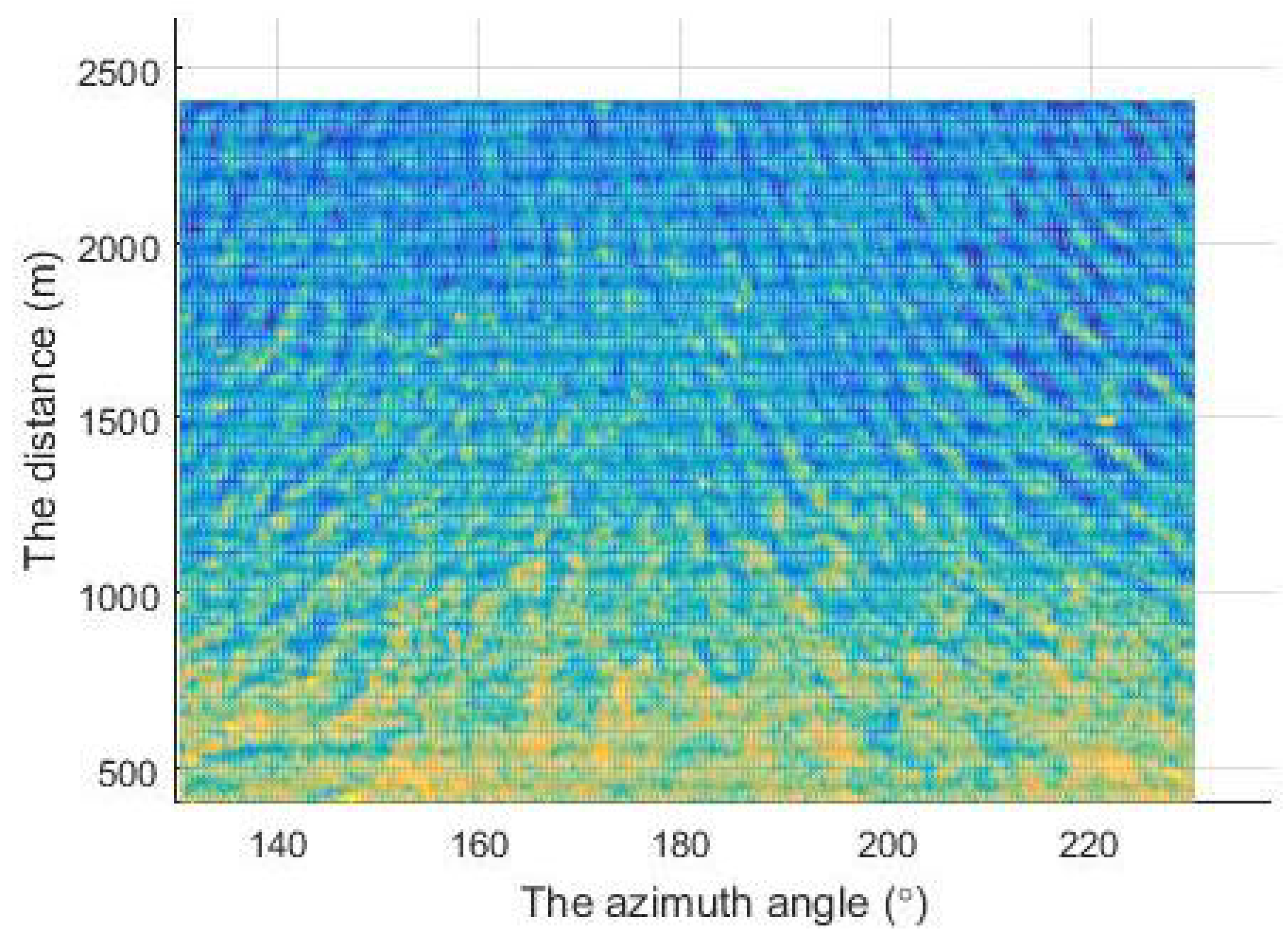
The selected analysis area from the acquired radar image is given in Figure 5. A wave buoy is deployed in the analysis area and the buoy record is used as the reference value. The deployed buoy is about 800 m from the radar antenna. The wave height is 2.7 m, the wave peak period is 7.88 s, and the wave direction is 77.6°, which are derived from the deployed wave buoy during the experiment. The surface current is about 2.21 m/s and the current direction is 62°, which are achieved from the simultaneously collected radar image sequence based on the weighted least square method in [32]. When the surface current of the dispersion relation is ignored, the retrieved significant wave height is 1.78 m. However, the obtained significant wave height is 2.37 m is close to the buoy record when the surface current is considered in the dispersion relation.
To further evaluate the influence of surface current on the inversion of wave height, the retrieved significant wave height by using the statistical method from the acquired shore-based radar images on 11–18 November 2014 is presented in Figure 6. The horizontal axis is the time sequence. The vertical axis is the retrieved significant wave height. The green circle denotes the extracted significant wave height by using the traditional shadow statistics method which ignores the influence of the surface current. The extracted significant wave height which considers the influence of the surface current is denoted by the blue triangle. The buoy is placed as an external reference device during the experiment, and the buoy record is indicated by the red cross.
The deployed wave buoy outputs the wave information every 20 min. However, a radar image sequence is acquired every 4 min. To minimize the analysis error, the wave period and wave direction retrieved based on the 3DFFT method from the radar image sequence instead of the buoy record is used in this paper. For the shadow statistical method, the required wave period can be extracted from the wave spectra based on the 3DFFT method or reference sensor, such as wave buoy. In this paper, the derived wave period based on the 3DFFT method is used to obtain the significant wave height. Although the shadow statistical method has the advantage of without external reference for calibration, the shadow statistical method still requires an external instrument, when the wave period is derived from the wave buoy. In practice, the cost of deploying a buoy is expensive and the wave buoy is easy to damage. Meanwhile, the shadow statistical method for retrieving wave height has great application value, since the X-band marine radar can sail with the ship. Thus, in this paper, the extracted wave period based on the 3DFF method from the radar image sequence is used to obtain the significant wave height. Then, the estimated wave height by using the shadow statistical method is averaged in 20 min.
In addition, the measuring principle of wave period between wave buoy and the radar image sequence is different. For the wave buoy, the data of 20 min in situ commonly is used to derive the wave period. However, for the 3DFFT method, the radar image sequence of about 75 s is used to calculate the wave period. Since the sea surface slope is calculated from the collected radar image, the extracted wave period from the radar image sequence instead of wave buoy is used in this paper, in order to minimize the error of wave height.
From Figure 6, we found that the fluctuation trend of the retrieved significant wave height based on the shadow statistical methods is similar to the buoy record under the same sea conditions. Moreover, the extracted wave height after considering the influence of the surface current fluctuates around the calculated wave height by using the ideal dispersion relation. The wave height extracted both considering and ignoring is close to the reference value in the first part of Figure 6. However, it can be observed that extracted wave height both considering and ignoring exists a great deviation from the reference value in the second part. Since the extracted wave height in the second part is higher than the reference value, the wave period or the surface slope calculated may exist great error. Based on the extracted wave height and the above analysis, we found that the significant wave height obtained has a large deviation from the reference value, when the surface velocity is not taken into account. However, when considering the influence of the surface current, the calculated significant wave height is closer to the buoy record than that of ignoring the influence of the surface current.
Figure 7 illuminates the scatter plots between the significant wave height estimated based on the shadow statistical methods and the buoy record. The scatter plot between the buoy record in situ and the extracted wave height based on the shadow statistical method without considering the influence of the sea surface current is given in Figure 7a. Figure 7b presents the scatter plot between the buoy record and the significant wave height estimated by the shadow statistical method, which considers the influence of the sea surface current. From Figure 7, it can be observed that the scatter distribution is relatively scattered when the sea surface current is not considered in the process of retrieving wave height, and the scatter distribution is relatively concentrated when the influence of sea surface current is considered. When the influence of the surface current is ignored for the wave height inversion, the correlation coefficient calculated between the retrieved wave height and the buoy record is 0.56, and the root mean squared error (RMSE) is 0.44. However, the correlation coefficient between the wave buoy and the extracted wave height, which considers the influence of the surface current, is 0.6, and the RMSE is 0.41. When the influence of sea surface current is considered by using the shadow statistical method, the correlation coefficient between the calculated wave height and the buoy record is larger than that of ignoring the influence of sea surface current, and the RMSE of the obtained wave height is smaller than that of ignoring the influence of sea surface current.
In [17], the effect of water depth is considered for retrieving wave height based on the shadow statistical method. In this paper, the influence of surface current is investigated. From the experimental results in [17] and this paper, it can be observed that considering both the wave depth and the surface current can improve the retrieving accuracy of wave height. However, the water depth has a greater effect for improving the retrieving accuracy than the surface current, compared to the experimental result in [17]. The reason is that the observation area of the collected radar belongs to the shallow water area and the retrieving accuracy is greatly affected by water depth. Meanwhile, the surface current velocity is relatively small during the experiment. Both the current velocity and the angle between the current direction and wave direction should be considered for extracting wave height. The surface current has an effect on retrieving wave height, when the current direction is parallel to the wave direction.
Compared with the existed shadow statistical method, the influence of the surface current on the inversion of wave height is investigated. The comparison illuminates that the retrieved wave height considering the influence of the surface current has a relatively better performance than that of the shadow statistical method existed which ignores the influence of the surface current. The experimental results demonstrate that the inversion accuracy of the significant wave height can be improved when the current factor is taken into account.
For retrieving wave height based on the shadow statistical method, the wave period is required and is mainly obtained from an external equipment, such as the wave buoy in [11,15,16]. Currently, the wave period can not be obtained through the shadow statistical method. However, the wave period can be retrieved based on the 3DFFT method. The dominant advantage of the shadow statistical method is that it does not require an external reference for calibration compared to the 3DFFT method. For the 3DFFT method, a linear relation between wave weight and the root mean square of SNR is used to retrieve wave height. An external reference is required to calibrate the linear relation. However, the linear relation is not always satisfied in practice. Although the wave period can be obtained from external reference or other methods, the shadow statistical method still has a great advantage for retrieving wave height. Meanwhile, the research on extracting wave period should be developed based on the shadow statistical method in the future.

5. Discussion

Although the wave height extracted has better performance when the surface current is taken into account the inversion process, the correlation between the wave height obtained based on the shadow statistical method and the buoy record is poor. The retrieving error is large when the surface current is large. The shadow statistical method still needs to be improved for the application in practice.
For the synthetic radar image based on the JoNSWaP spectrum, we found that the inversion error increases with the increase in surface current velocity when the surface current is parallel to the wave direction. When the surface current is large, the surface current should be considered for improving the inversion accuracy of the wave height in the future. Commonly, the surface current is not perpendicular to the wave direction. The retrieving results depend on both the current velocity and the angle between the wave direction and the current direction. The effect of the surface current on retrieving the wave height is needed further investigation in the future.

6. Conclusions

The shadow statistical method has great research value, because it does not require external reference and plenty of observation data for calibration. When the shadow statistical method is utilized to calculate the significant wave height from the X-band marine radar images, the relationship among wave period, the significant wave height, and the sea surface slope is studied. However, it is assumed that the sea wave accords with the ideal dispersion relation in the inversion process, and the influence of the sea surface current is ignored. Thus, based on the shadow statistical method for calculating wave height, the influence of the sea surface current on the inversion accuracy is analyzed in this paper.
The marine radar images which contain surface current information are utilized to carry out experiments and certify the influence of sea surface current on the wave height inversion. The scatter plots show that the absolute error of wave height calculated by using the shadow statistical method is small and the correlation coefficient is large when the surface current is considered in the dispersion relation. The experimental results illuminate that the retrieving accuracy of significant wave height could be improved when the influence of the sea surface current is considered. However, for the inversion of wave height, the influence of the surface current is still required for further investigation under different sea conditions. Moreover, the strategy of accurately estimating surface slope is still required for improving the performance of the shadow statistical method.

Author Contributions

Conceptualization, Y.W. and Z.L.; methodology, Y.W., Y.L. and Z.L.; resources, Y.L. and Y.Z.; software, Y.W. and Y.Z.; validation, Y.W. and Y.L.; writing—original Draft Preparation, Y.W. and Y.L. All authors have read and agreed to the published version of the manuscript.

Funding

This research was supported in part the Henan Provincial Science and Technology Research Project under Grand No. 212102210272.

Institutional Review Board Statement

Not applicable.

Informed Consent Statement

Not applicable.

Data Availability Statement

The part data presented in this study are available on request from the corresponding author.

Conflicts of Interest

The authors declare no conflict of interest.

Abbreviations

The following abbreviations are used in this manuscript:
DOAJDirectory of open access journals
TLAThree letter acronym
LDLinear dichroism

References

  1. Huang, W.; Liu, X.; Gill, E.W. Ocean wind and wave measurements using X-band marine radar: A comprehensive review. Remote Sens. 2017, 9, 1261. [Google Scholar] [CrossRef] [Green Version]
  2. Chen, X.; Huang, W. Identification of rain and low-backscatter regions in X-band marine radar images: An unsupervised approach. IEEE Trans. Geosci. Remote Sens. 2020, 58, 4225–4236. [Google Scholar] [CrossRef]
  3. Lu, Z.; Yang, J.; Huang, Y. Sea wind direction extraction by X-band radar in moving platform. Syst. Eng. Electron. 2016, 38, 799–803. [Google Scholar]
  4. Chernyshov, P.; Vrecica, T.; Streßer, M.; Carrasco, R.; Toledo, Y. Rapid wavelet-based bathymetry inversion method for nearshore X-band radars. Remote Sens. Environ. 2020, 240, 111688. [Google Scholar] [CrossRef]
  5. Gangeskar, R. Verifying high-accuracy ocean surface current measurements by x-band radar for fixed and moving installations. IEEE Trans. Geosci. Remote Sens. 2018, 56, 4845–4855. [Google Scholar] [CrossRef]
  6. Wei, Y.; Zheng, Y.; Lu, Z. A Method for retrieving wave parameters from synthetic X-band marine radar images. IEEE Access 2020, 8, 204880–204890. [Google Scholar] [CrossRef]
  7. Chen, Z.; Chen, X.; Zhao, C.; Li, J.; Huang, W.; Gill, E.W. Observation and intercomparison of wave motion and wave measurement using shore-based coherent microwave radar. IEEE Trans. Geosci. Remote Sens. 2019, 57, 7594–7605. [Google Scholar] [CrossRef]
  8. Young, I.; Rosenthal, W.; Ziemer, F. A three dimensional analysis of marine radar images for the determination of ocean wave directionality and surface currents. J. Geophys. Res. 1985, 90, 142–149. [Google Scholar] [CrossRef] [Green Version]
  9. Nieto-Borge, J.C.; Hessner, K.; Jarabo-Amores, P.; MataMoya, D. Signal-to-noise ratio analysis to estimate ocean wave heights from x-band marine radar image time series. IET Radar Sonar Navig. 2008, 2, 35–41. [Google Scholar] [CrossRef] [Green Version]
  10. Plant, W.J.; Gordon, F. Wave shadowing and modulation of microwave backscatter from the ocean. J. Geophys. Res. Ocean. 2012, 117, 1–14. [Google Scholar] [CrossRef] [Green Version]
  11. Gangeskar, R. An algorithm for estimation of wave height from shadowing in X-band radar sea surface images. IEEE Trans. Geosci. Remote Sens. 2014, 52, 3373–3381. [Google Scholar] [CrossRef]
  12. Lund, B.; Collins, C.O.; Graber, H.C.; Terrill, E.; Herbers, T.H.C. Marine radar ocean wave retrieval’s dependency on range and azimuth. Ocean. Dyn. 2014, 64, 999–1018. [Google Scholar] [CrossRef]
  13. Dankert, H.; Horstmann, J.; Rosenthal, W. Wind- and wave-field measurements using marine X-band radar-image sequences. IEEE J. Ocean. Eng. 2013, 30, 534–542. [Google Scholar] [CrossRef]
  14. Vicen-Bueno, R.; Horstmann, J.; Terril, E.; Paolo, T.D.; Dannenberg, J. Real-time ocean wind vector retrieval from marine radar image sequences acquired at grazing angle. J. Atmos. Ocean. Technol. 2013, 30, 127–139. [Google Scholar] [CrossRef]
  15. Liu, X.; Huang, W.; Gill, E.W. Wave height estimation from shipborne X-band nautical radar images. J. Sens. 2016, 2016, 1078053. [Google Scholar] [CrossRef]
  16. Liu, X.; Huang, W.; Gill, E.W. Comparison of wave height measurement algorithms for ship-borne X-band nautical radar. Can. J. Remote Sens. 2016, 42, 343–353. [Google Scholar] [CrossRef]
  17. Wei, Y.; Lu, Z.; Pian, G.; Liu, H. Wave height estimation from shadowing based on the acquired X-band marine radar images in coastal area. Remote Sens. 2017, 9, 859. [Google Scholar] [CrossRef] [Green Version]
  18. Ardhuin, F.; Gille, S.T.; Menemenlis, D.; Rocha, C.B.; Rascle, N.; Chapron, B.; Gula, J.; Molemaker, J. Small-scale open ocean currents have large effects on wind wave heights. J. Geophys. Res. Ocean. 2017, 122, 4500–4517. [Google Scholar] [CrossRef] [Green Version]
  19. Breivik, Ø.; Mogensen, K.; Bidlot, J.-R.; Balmaseda, M.A.; Janssen, P.A.E.M. Surface wave effects in the NEMO ocean model: Forced and coupled experiments. J. Geophys. Res. Ocean. 2015, 120, 2793–2992. [Google Scholar] [CrossRef] [Green Version]
  20. Ludeno, G.; Reale, F.; Dentale, F.; Carratelli, E.P.; Natale, A.; Serafino, F. Estimating Nearshore Bathymetry from X-Band Radar Data. Coast. Ocean Obs. Syst. 2015, 265–280. [Google Scholar] [CrossRef]
  21. Atkinson, J.; Esteves, L.S.; Williams, J.J.; Bell, P.S.; McCann, D.L. Nearshore monitoring with X-band radar: Maximizing utility in dynamic and complex environments. J. Geophys. Res. Ocean. 2021, 126, e2020JC016841. [Google Scholar] [CrossRef]
  22. Ludeno, G.; Serafino, F. Estimation of the significant wave height from marine radar images without external reference. J. Mar. Sci. Eng. 2019, 7, 432. [Google Scholar] [CrossRef] [Green Version]
  23. Liu, X.; Huang, W.; Gill, E.W. Estimation of significant wave height from X-band marine radar images based on ensemble empirical mode decomposition. IEEE Geosci. Remote Sens. Lett. 2017, 17, 1740–1744. [Google Scholar] [CrossRef]
  24. Wang, L.; Hong, L. Oean wave height inversion under low sea state from horizontal polarized X-band nautical radar images. J. Spat. Sci. 2021, 66, 75–87. [Google Scholar] [CrossRef]
  25. Chen, X.; Huang, W. Spatial-temporal convolutional gated recurrent unit network for significant wave height estimation from shipborne marine radar data. IEEE Trans. Geosci. Remote Sens. 2021. [Google Scholar] [CrossRef]
  26. Wu, L.-C.; Doong, D.-J.; Lai, J.-W. Influences of nononshore winds on significant wave height estimations using coastal X-band radar images. IEEE Trans. Geosci. Remote Sens. 2021. [Google Scholar] [CrossRef]
  27. Shen, C.; Huang, W.; Gill, E.W.; Carrasco, R.; Horstmann, J. An algorithm for surface current retrieval from X-band marine radar images. Remote Sens. 2015, 7, 7753–7767. [Google Scholar] [CrossRef] [Green Version]
  28. Hessner, K.G.; El Naggar, S.; von Appen, W.-J.; Strass, V.H. On the reliability of surface current measurements by X-band marine radar. Remote Sens. 2019, 11, 1030. [Google Scholar] [CrossRef] [Green Version]
  29. Chen, Z.; Zhang, B.; Kudryavtsev, V.; He, Y.; Chu, X. Estimation of sea surface current from X-band marine radar images by cross-spectrum analysis. Remote Sens. 2019, 11, 1031. [Google Scholar] [CrossRef] [Green Version]
  30. Huang, W.; Carrasco, R.; Shen, C.; Gill, E.W.; Horstmann, J. Surface current measurements using X-band marine radar with vertical polarization. IEEE Trans. Geosci. Remote Sens. 2016, 54, 2988–2997. [Google Scholar] [CrossRef]
  31. Yang, Z.; Huang, W.; Chen, X. Evaluation and mitigation of rain effect on wave direction and period estimation from X-band marine radar images. IEEE J. Sel. Top. Appl. Earth Obs. Remote Sens. 2021, 14, 5207–5219. [Google Scholar] [CrossRef]
  32. Yuan, G.; Jia, R.; Dai, Y.; Li, Y. Research on the extraction algorithm of ocean surface current based on sea clutter image. Chin. J. Sci. Instrum. 2011, 32, 1845–1850. [Google Scholar]
Figure 1. The flowchart of retrieving significant wave height based on the shadow statistical method.
Information 12 00303 g001
Figure 2. The simulated marine radar image in Cartesian coordinate.
Information 12 00303 g002
Figure 3. The calculated sea surface slope in the azimuthal direction.
Information 12 00303 g003
Figure 4. The acquired shore-based marine radar image.
Information 12 00303 g004
Figure 5. The collected marine radar image in Cartesian coordinates.
Information 12 00303 g005
Figure 6. The sequence of the significant wave height.
Information 12 00303 g006
Figure 7. The scatter plots of the significant wave height between the buoy record and the radar-derived. (a) The scatter plot of the wave height ignoring the influence of the surface current; (b) The scatter plot of the wave height considering the influence of the surface current.
Information 12 00303 g007
Table 1. The retrieved significant wave height with different sea surface current.
Surface
Current (m/s)
Wave Peak
Period (s)
Estimated
Wave Slope
Retrieved Wave Height (m)
Ignoring the CurrentConsidering the Current
011.00.0273.683.68
0.510.70.0293.843.62
110.40.0303.983.54
29.80.0324.293.38
39.30.0324.273.04
48.90.0374.983.28
58.50.0385.013.08
Table 2. The main configuration parameters of X-band marine radar.
Radar ParametersThe Performance
Electromagnetic Wave Frequency9.3 GHz
PolarizationHH
Antenna Length1.8 m
Horizontal Beam Width0.9°
Vertical Beam Width21°
Antenna Angular Speed22 r.p.m.
Pulse Width50 ns
Pulse Repetition Frequency1300 Hz
Publisher’s Note: MDPI stays neutral with regard to jurisdictional claims in published maps and institutional affiliations.