Article

Ontology-Mediated Historical Data Modeling: Theoretical and Practical Tools for an Integrated Construction of the Past

by
Esther Travé Allepuz
1,*,
Pablo del Fresno Bernal
2 and
Alfred Mauri Martí
3
1
Department of History and Archaeology, Universitat de Barcelona, 08001 Barcelona, Spain
2
Sistemes de Gestió de Patrimoni SCCL, 08004 Barcelona, Spain
3
Centre d’Estudis Martorellencs, 08760 Martorell, Spain
*
Author to whom correspondence should be addressed.
Information 2020, 11(4), 182; https://doi.org/10.3390/info11040182
Submission received: 26 February 2020 / Revised: 20 March 2020 / Accepted: 26 March 2020 / Published: 28 March 2020
(This article belongs to the Special Issue Digital Humanities)

Abstract

:
Building upon the concepts of constructed past theory, this paper introduces the outcome of ontology-mediated data modeling developed by the authors within the last 15 years. Assuming that the past is something constructed through reflection of former times, one of our major concerns is guaranteeing the traceability of the construction process of an integrated historical discourse built from all available sources of information, regardless of their origin or nature. Therefore, by means of defining key concepts such as ‘unit of topography’ and ‘actor’, we created an information system for data gathering and exploitation and applied it to some experiences of construction of the past. When applied within the archaeological domain, the result is an archaeological information system interoperable with other sources of historical information. Its strength is that it ensures the traceability of the process from the beginning avoiding the introduction and repetition of errors within the system. Along with the main case example developed in this paper, we also summarize some other data modeling examples within the same conceptual framework.

1. Introduction

This study addresses some problems and tested solutions—that historians experience when approaching knowledge of the past. According to the principles of constructed past theory, published recently [1], we aim to introduce and discuss the validity of our information system to gather and exploit historical data, and the underpinning concepts of our methodological approach. Our main goal is to strengthen the chances of building the historical discourse on a scientific basis, taking into account the risks of bias and ideological implication concomitant to Social Sciences and Humanities (SSH) and describing our methodology as a measure to mitigate risks.
Indeed, the narration of the past offered by historians—the term is understood here in the broadest possible sense, including archaeologists, palaeographers, anthropologists, philologists, and all scholars dealing with the past in some way at some point of their research—is a construction built from what is left, a collection of remains of different nature and kind. The uncovering of these remains and their articulation within a creative process in no way compromises the ontology of the past itself —that it did happen [2] (pp. 591–592). Therefore, the past is represented, mediated by witnessing or speaking for it in its absence and connecting it with contemporary understanding.
Nowadays, so-called ‘digital humanities’ offer new ways to develop and disseminate humanistic research. Despite this, their highest interest are the new chances of addressing research in SSH in a brand new way, not only faster, but more effective in terms of data gathering and exploitation, and hence transforming investigation itself by asking new and more complex questions. Incomprehensibly, history as a discipline does not seem to have been the most enthusiastic participant within this digital turn, occasionally encountering endless debates about the usefulness of digital tools themselves. However, some historians are too committed with the reliability and traceability of past construction to disregard the chances digital humanities offer in this domain, even when their digital skills have developed through inquisitiveness and everyday use, instead of a regular training program [3].
The fact is that—beyond the conceptual changes—Digital Humanities actually made us face a change of paradigm in the processes of historical research in which:
  • Available tools allow us to deal with massive datasets, some of which were disregarded until recently as marginal or non-significant.
  • Interdisciplinary teamwork is key to build a richer, fairer and more precise construction of the past.
  • Information sources of diverse origin and nature must be integrated within a cross-disciplinary perspective.
  • Open datasets become compulsory within a new research Open Science framework.
All these new scenarios require new management of information fluxes claiming for the theoretical definition and practical development of information systems for a safe and efficient information management and research good practices. According to the main research developed in recent years and summarized in the following section, our main goal within this paper is to propose a specific ontology-mediated data modeling and a research information system (RIS) built accordingly. Regardless of the origin or nature of information sources susceptible of being considered as a vestige or a reflection [1] (p. 14) of the past, it is possible to exploit them within a shared code, and so we aim at offering our conceptual proposal and some examples of successful application. One of these examples, is the successful implementation of an Archaeological application of the Research Information System (ARIS), called SigArq.

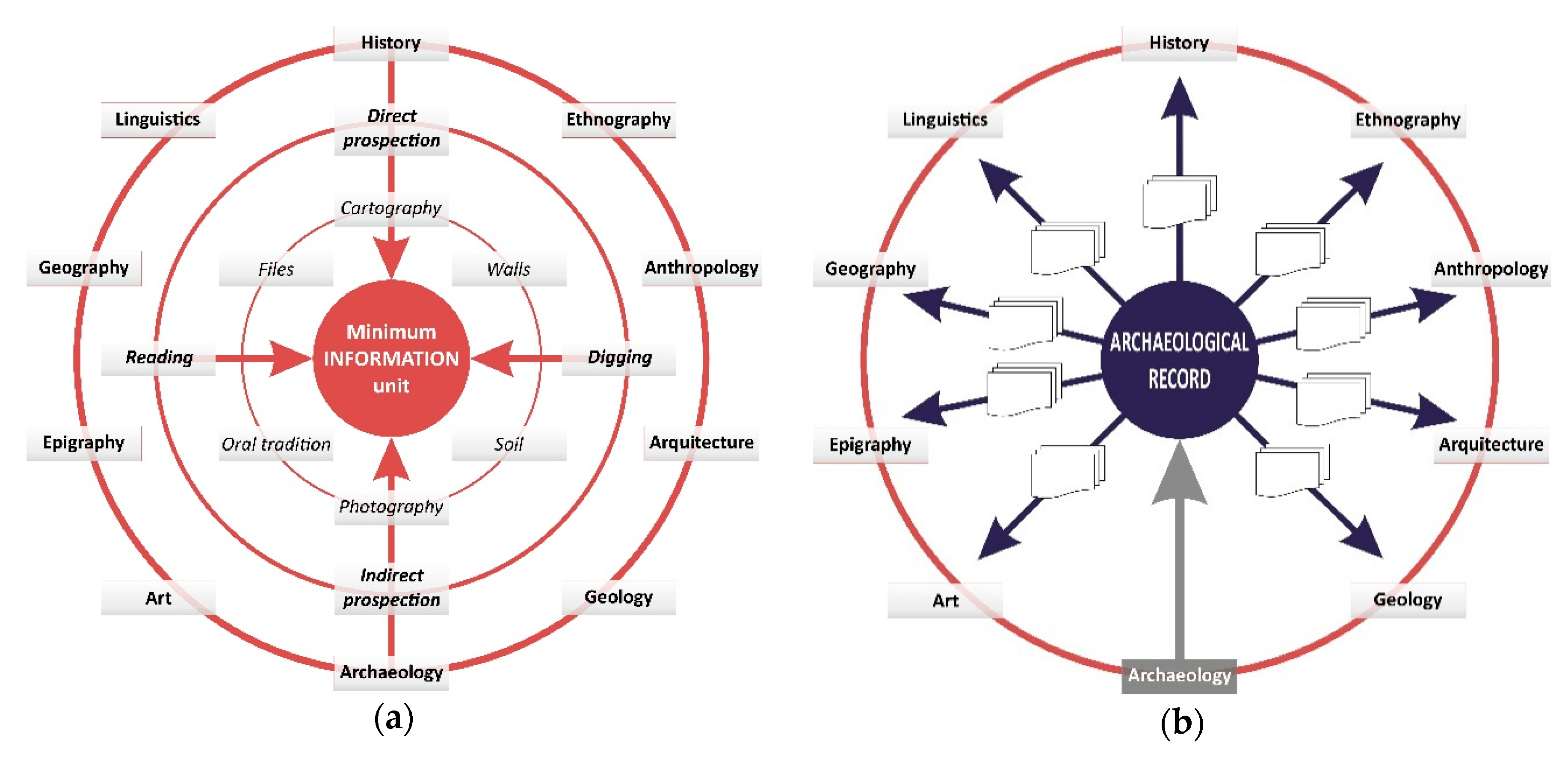
2. State-of-the-Art: Constructed Past Theory and Theoretical Approaches from Archaeology and Record Management

Thibodeau’s Constructed Past Theory (CPT) [1] has shed new light in the conceptualization of past construction, which is not new particularly in archaeological theory, where material vestiges never speak by themselves, but it is the archaeologist that must give them their significance [4,5]. Figure 1 provides a summary synthesis of CPT, wherein the Constructed Past is the final product of a process in which a Target Past evolves during the In-Progress Construction process according to the Intentional Domain. This comprises the Intent of Construction and the Sphere of Interest, both classes being determined by the researcher.
Intent of Construction and Sphere of Interest are interdependent classes, as the first shapes the process and its results and the second specifies the period under investigation and what is of interest. Therefore, the final construction of the past should satisfy the intent of construction and be about the sphere of interest. Four subclasses are involved within the Sphere of Interest: Entity, Event, Process, and State of Affairs. An ‘Entity’ is something, whether conceptual or physical, that existed and that had, at least, one inherent and persistent property. An Event, in contrast, is a change in an Entity. What changes and the nature of the change are two defining properties of the Event. Several events aggregated as steps may define a Process. Finally, Thibodeau defined the State of Affairs as a set of one or more assertions, all of which are true for the same chronological period and concern the same or related objects that are either instances of the Entity, Event, or Relationship, or their subclasses.
Entities and Events have an Involvement relationship—also expressed as a class—including four subclasses: Participant, Observer, Altered, and Instrument, according to the nature of the change occurred to the Entity during the Event. When human action gets into the scene, it introduces a subclass of Event: Action. Thus, Action is an Event in which human beings have an active role as participants.
The Involvement relationship between Entity and Event and the role of humans in between is particularly interesting to us because our recent research on ontology-mediated data modeling fits really well in Thibodeau’s CPT as a practical case and proposal for further development, as we will demonstrate in forthcoming sections. Any In-Progress Construction of the past under a determined Intentional Domain uses Construction Materials that might be—Item or Composite, Vestiges or Reflections. Vestiges are objects that existed in the past and survive the time of the sphere of interest, and Reflections are information objects produced in the course of construction. Being archaeologists ourselves, we have been deeply concerned with the selection and use of vestiges within Historical Science, as material archaeological evidence has sometimes been disregarded in favour of Archival Capital or written sources in general. Fortunately, recent times have fruitfully changed this perception, particularly for the medieval and post-medieval period. Medieval archaeology—especially under the methodological perspective of landscape archaeology—has contributed to the material turn [6] in Archaeology, Anthopology, History, and other past-constructing disciplines, even though this turn has not always been exempt of debate [7,8,9].
Apart from Thibodeau’s recent abstract approach—as stated by the author [1] (p. 16)—few references address the problem of ‘managing information’ in practical terms in order to build an integrated historical discourse dealing at once with sources of information from many different origins and supports [10,11,12]. Some of them are still highly theoretical [11] or archaeology-based [12], and, frequently, specific research about ontology-based data management only addresses historical problems tangentially [13,14]. Indeed, we are indebted to the archaeological theory and practice in the development of our data modeling, particularly regarding landscape archaeology [15,16,17]. Recently, considerable efforts have been made in order to develop common standards to ease data exploitation, and to empower digital research in the fields of History, Language Studies, Cultural Heritage, Archaeology, and related fields in the domain of Social Sciences and Humanities (SSH). The already completed PARTHENOS project [18] was a beautiful example of them, and it hosted an archaeological experience of research infrastructure implementation called ARIADNE [19]. Through this archaeological data-standardization-based project and other subsequent experiences, the archaeological domain has developed data integration practices through metadata introduction by means of controlled vocabularies.
Despite this, most of these experiences, particularly in the archaeological discipline, tackle with data standardization in order to make the results of research exchangeable under FAIR conditions, but very few suggestions are provided in order to deal with the FAIR character of basic research itself. Before reaching exportable results, Historians in general and Archaeologists in particular are file generators and our aim is to introduce and share the way in which we deal with the records produced since the very beginning of our research until the final product or report is obtained. Hence, the Research Information System (RIS) introduced below in this paper and its practical cases are part of an interdisciplinary proposal built upon the basis of Records Management [20,21] and Conceptual Modeling [22]. Our RIS proposal and its practical application through the SigArq ARIS can be used as a domain solution or an example of International Research on Permanent Authentic Records in Electronic Systems (InterPARES). Actually, most of the design of the system and its File Management Classification Chart as a result of identifying research processes and giving response to them follow the InterPARES methodological approach [23] (pp. 6–7). A. Mauri [24,25] set the conceptual basis of our Research Information System (RIS) as part of his MSc and PhD dissertations and applied it to the study of the County of Barcelona in the Early Medieval Period [25] (pp. 103–384). Although some experiences in historical data management and computing have been known since 2005 [26,27], most of them deal almost exclusively with written evidence while data integration experiences through interoperable minimum information units are rare. Mauri’s study [25] built an integrated construction of the past for the first time, gathering information from different sources regardless of their origin or nature. The concepts of ‘Unit of Topography’ (UT) and ‘Actor’ (Ac) were defined then as minimal ‘Units of Information’ (UI) of historical knowledge and the RIS were built accordingly [28]. Further crosscutting research used those information units at the basis of archaeological data management in connection with E. C. Harris’ concept ‘Unit of Stratigraphy’ (US), and P. Del Fresno conceptualized the main structure of his Archaeological Research Information System (ARIS) [29,30] as advanced development of the original RIS. More recently, the concepts of UT and Ac were applied to mercantile accounting books from the 15th Century AD and the RIS was improved [31,32].
More than 20 years after its first conceptualization, now we are in a good position to review the system structure and to offer—through different examples—a more complete and tested proposal according to its underpinning concepts and ontology. In the following Section 3 and Section 4, the main concepts are defined, their relationships established, and the software applications described. Anyway, our RIS is still a tool in construction and our contribution aims at exchanging our thoughts and perceptions with other researchers as well, in order to build a better and even more functional information system.

3. Underpinning Ontological Concepts and Data Modeling: The Methodological Basis of RIS

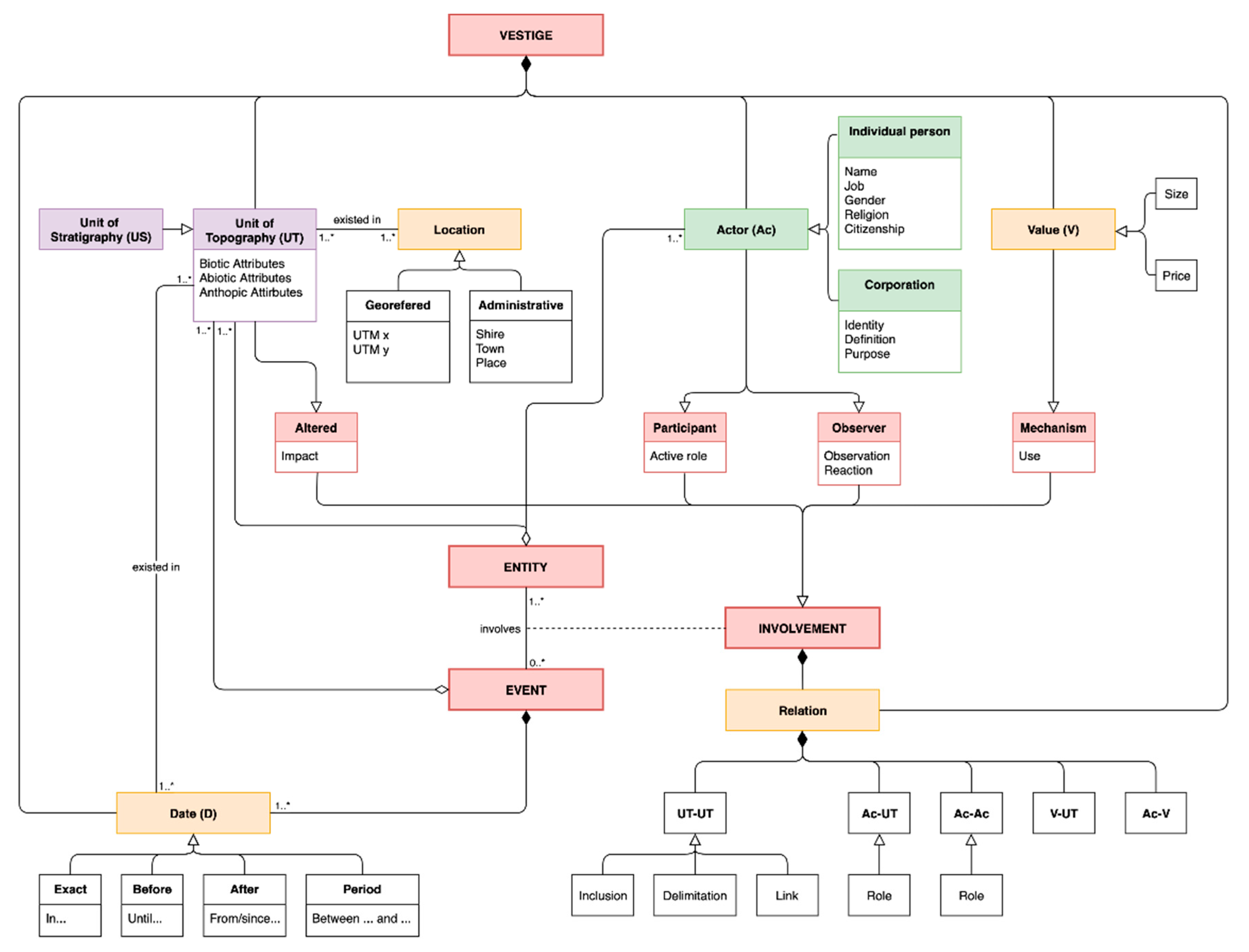
3.1. Definition of Minimum Information Units: Conceptual Data Modeling

The minimal UI defined as Unit of Topography (UT) and Actor (Ac) are identifiable and exploitable from any vestige of the past regardless their origin or nature. If understanding—as Thibodeau did in his CPT [1] (p. 13), and we do in our RIS—that any vestige or reflection of the past is susceptible to be considered as raw material for past construction, the dichotomy between archaeology and history—material and written sources—disappears. So do any other differences between information sources such as ethnography, geography, iconography, and many others. In fact, two key interdependent concepts to identify historical information are time and change, and any vestige or reflection able to inform about those is indeed a source for building historical knowledge.
Scholars have probably not paid particular attention to the idea of Time as an ontological concept, probably because of the confusion between time and chronology or succession of facts, or maybe because of the consideration of time as an absolute and independent magnitude that acts as a container of events and entities. Time understood as such has been revealed as an insufficient and useless concept. The goal of historical research—or Past Construction—is to identify and describe a sum of environmental, ecological, economic, social, cultural, political or whatsoever factors that challenge and shape human life within a determined period of time (Sphere of Interest). By means of this characterization of factors, historians aim at defining models to detect and measure permanence in front of change. This rhythm or cadence between what happens before and what comes later is what we understand as Historical Time [33].
Accordingly, our proposal is to identify the information components of any vestige as a single and unique unit informing about entities, or events—in Thibodeau’s terms [1] (pp. 7–9)—or both, and their relations or values. Figure 2 summarizes our data modeling in relation with Constructed Past Theory as a ULM diagram. Vestiges or reflections of the past can inform about facts, those who performed, witnessed or suffered these facts, the mechanisms making them happen, and the time and place in which they occurred. Each one of these elements is represented as a vestige’s component. The facts themselves (Units of Topography) are something that existed—entities—or something that happened—events. Both elements took place in a determined place and time, regardless of the fact that these spatiotemporal coordinates are known or unknown to future generations. Therefore, the main components of vestiges are defined as follows:
  • Unit of Topography (UT): It is the evidence of an action or situation that can be located in space and time, regardless of the specificity of the information source and its biotic, non-biotic or anthropic origin. Each UT has a specific location and date. Location can be expressed as a UTM coordinate or as an administrative delimitation that might have changed during history. Some UT examples are the existence of a vegetal specimen in a determined area; the consecration of a church; the transaction of a property; the existence of a necropolis; the remains of a pathway, a birth, a marriage, a death or a burial, etc.
  • Actor (Ac): It is the individual or corporative, active or passive, protagonist of an action identified as a UT. If being an individual, their attributes are their name, gender, religion, citizenship, date of birth and death, etc. Different individual actors gathered for a given period of time with a particular purpose and under determined conditions can act as corporative actors. In CPT’s terms, Actors should be considered Entities, while UTs could be Entities or Events.
  • Value (V): Expressed as a price or a size magnitude, it is a mechanism. Through the value of something, the Actor makes the UT possible.
  • Date (D): It is the specific time when the event happened. If the entity is related to permanence and the event relates to change, at least one entity has to be involved in an event [1] (p. 7), and date is a component of an event or a process. We can identify as a date an exact point in time, a period before an exact point or after it, or a period between two exact points.
The way an Entity is involved in an Event is specified in an association class called Involvement in CPT [1] (p. 8). We might feel more comfortable with the term ‘Relationship’ here, in order not to interpret a priori any (active or passive) kind of involvement. Different possible relationships between UT, Ac or V are expressed as components of the involvement. These are:
  • UTUT: A UT can include, link or delimitate another UT. Hence, Inclusion, Delimitation, and Link are classes of the UT–UT relationship.
  • AcUT: This relationship is expressed as the active/passive role the Actor plays within a UT.
  • AcAc: Any familial, political, social or economic relationship identified between actors is a condition for events to happen and entities to transform. Through this relationship, individual actors can join into corporative actors forming then new entities.
  • VaUT: This relation expresses the price or size of a UT.
  • AcVa: The use of this value by the actor—as expressed in this class of relationship—is the mechanism to create a new UT.
This conceptual data modeling is applicable to any kind of historical source regardless of its origin, but the nature of sources and the specific methods of each social science require minor tool adaptation. Text labeling is a useful tool for data gathering in written vestiges. A few examples of text labeling and table edition in Appendix A offer practical application of data gathering from archival capital. Datasets are then collected as tables in interoperable databases built according to the sphere of interest of specific research projects. The main database structure includes UT (Table A1) and Ac (Table A2) related tables as its main components, though research objectives might require other related tables such as Values or Relation (Table A3). Regardless of the number of tables within the database, data must always be stored in such form, placing variables in columns and observations in files, according to a tidy data structure [34]. Graphic, iconographic, or audiovisual material might require other UT/Ac-identification techniques so that the degree of table completion might be lower, but data identification and gathering follows the same system, as demonstrated with examples in Appendix B.
Dealing with material vestiges requires the appropriate excavation and recording methods of archaeological science. Nowadays, the most extended and accepted archaeological method is the stratigraphic extensive excavation proposed by E. C. Harris [35], where the ‘Unit of Stratigraphy’ (US) is the minimal UI. Our concept of UT owes much to Harris’ stratigraphic approach, since UT and US are comparable and interoperable units, as we will explore more deeply in the discussion section. The application of our RIS to the Archaeological domain and the creation of SigArq is one major achievement shown in the results section below.

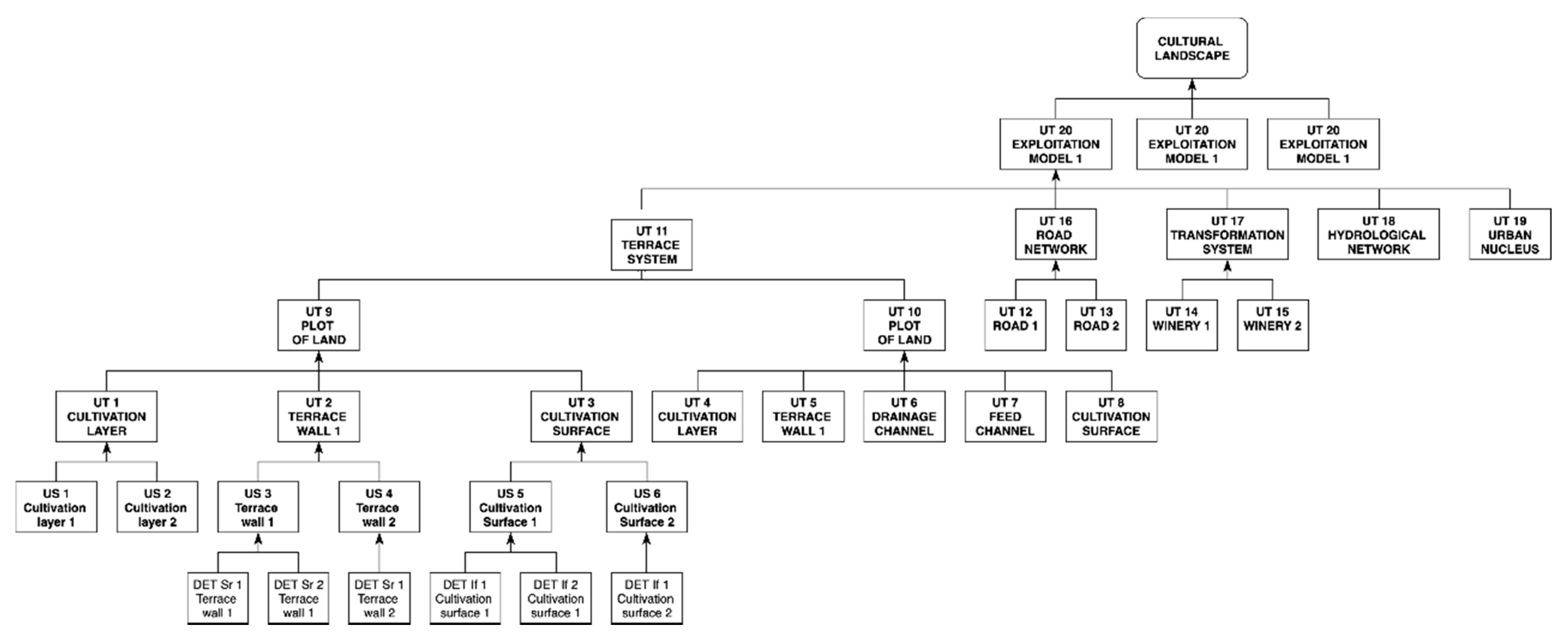
3.2. Units of Topography and Units of Stratigraphy: Towards an Archaeological RIS

The final stage of archaeological fieldwork is the production of a report or the publication of a paper that will hopefully be integrated in the Construction of the Past. As the so-called material [36,37,38,39] and spatial turns [40,41,42,43] develop in Historical Science, data integration, and the search for a common and shared exploitation code is a much-needed strategy.
Different procedures for data gathering according to the specificity of the vestige must lead unavoidably to a common exchangeable information unit, as illustrated in Figure 3. Our research explored how to connect a long-term accepted archaeological concept—Unit of Stratigraphy—to data obtained from other vestiges and reflections, and how to deal with the significant difference between them regarding their materiality or immateriality.
As defined by E. C. Harris, archaeological US represent an archaeological aspect of the cycle of time. They are of universal character and can be found on any archaeological site in the world [35] (p. 42). Despite the fact that all US could be considered as UT accordingly, a matter of scale needs to be solved in order to guarantee interoperability between archaeological record and archival capital. Material vestiges such as postholes or burials include several US each and, in that case, it is not operational to consider every single US as a UT. The answer to the problem is provided by A. Carandini’s definition of “Activities and Phases” [44] (p. 143) as groups of US and groups of activities respectively. UT recorded from archival capital can have a material equivalent in activities or phases of an archaeological site, and determining this correlation is a collaborative task of archaeologists and historians. Figure 4 shows an example of this US–UT correlation in a landscape analysis of agricultural activities.
This conceptual data modeling is permanently under development, but the definition of its main architectural structure led us to put into practice some fruitful research experiences through GIS tool-development and data exploitation. The underpinning idea of the RIS is that data gathering needs to be monitored and records must to be built under normalized codes in order to ensure interoperability and interdisciplinarity in the SSH domain. The archaeological RIS SigArq [45] is a clear example of this data integration and management.

4. Results: Experiences of Past Construction and Tool Development

Data gathering and exploitation according to the use of UT and Ac as minimal units of information linked though values and relationships led to a more precise knowledge of the County of Barcelona [25]. Past Constructed under those principles was generally accepted as a reflection—in Thibodeau’s terms [1] (p. 14)—and used in further research [10,29,46]. Research developed in this framework particularly reflects the chances of data integration from written sources, ethnographic approaches, field archaeology, and material sciences [47] (pp. 125–129,143).
Nevertheless, the most complete application of our methodological approach is the conceptualization and development of the Archaeological RIS SigArq, although some other experiences are currently under construction [31,32]. Figure 5 shows the general design of this ARIS as a system of subsystems in which different existing computing tools are independent, interconnected, and distributed along its architectural levels. All these devices are concomitant to the ARIS as long as they support a transversal management of the heritage, concerning both their agents and subjects. The ARIS is obviously web-supported and allows all subsystems to be interconnected.
In order to make this interconnection possible and according to the integration of archaeological record within the principles of Records Management [48,49], the documentation and analysis of vestiges follow a normalized protocol of data collection summarized in a file classification chart. These are supported within SigArq Geographic Information System, which allows researchers to gather all informative dimensions of US in one single database.

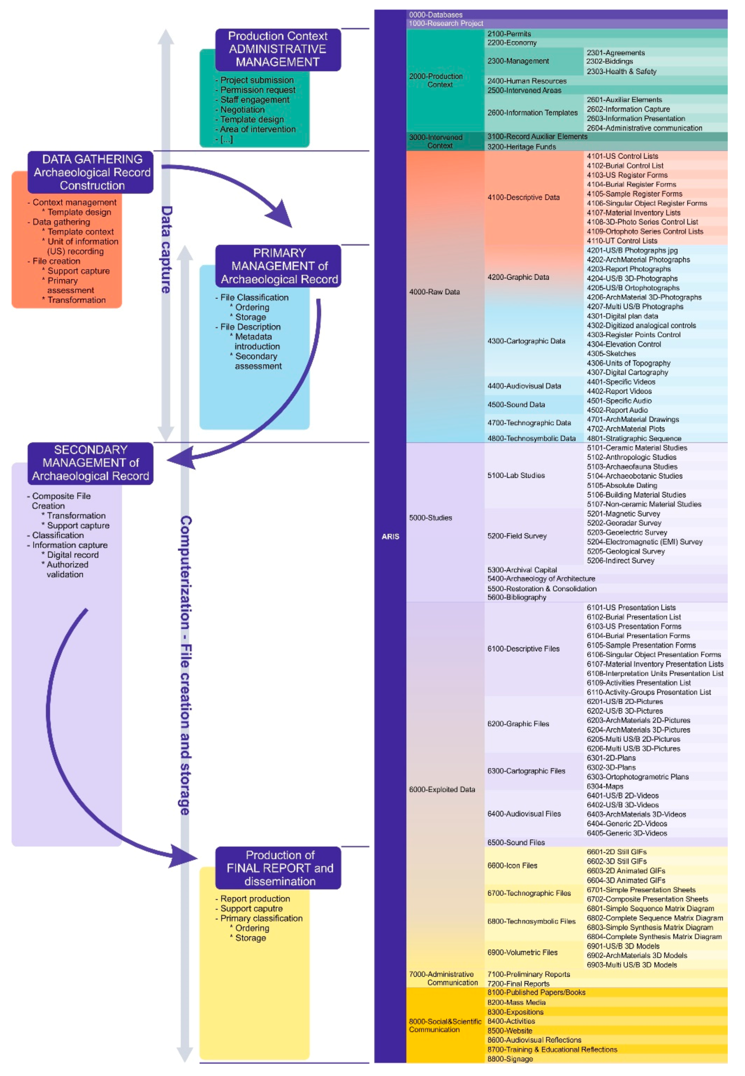
4.1. Archaeological Information System: Classification Chart as File Management Tool

Building the archaeological record according to the principles of Records Management implies identifying the main processes in research from the creation of the file production context until the delivery of the final report attesting the research project completion, as suggested by the InterPARES’s methodological approach [23] (pp. 6–7). These processes originate items which are ordered and hierarchized in files and series accordingly. Building the archaeological record, in particular, produces several files that are representative of the different dimensions of US as a minimal information unit. These dimensions are:
  • Descriptive dimension: US description includes information about its class (deposit, structure or interface), definition (e.g., layer, wall, hole, etc.), natural or anthropic origin, and interpretation (e.g., construction, destruction, use, erosion).
  • Graphic dimension: Photographic register records the graphic dimension of US through different pictures (aerial, general, detail) that are stored and identified through normalized metadata.
  • Cartographic dimension: As stated in archaeological method, a single-layer plan for every US records the basic cartographic data by means of drawing the boundary contours of the US, and placing some evenly distributed elevations on the plotted area [35] (pp. 95–104).
  • Temporal dimension: Defining the stratigraphic sequence is the way to record the temporal dimension of the US, according to the physical relation between them [35] (pp. 34–39).
These four dimensions are part of the raw data gathering included in the first of the processes –building the archaeological record—as shown in Figure 6. Defining the methodological work processes precisely leads the researcher through the project management and execution through different activities, series, and composite files [50], according to the classification chart shared by the authors and their team.
Data gathering is the first step of the research process. Each US is recorded according to its four dimensions (descriptive, graphic, cartographic, and temporal) by means of filling a registration form, taking some pictures, drawing its plan and recording the physical relation between different units. During this process, primary assessment of data takes place, as researchers select the correct and valid data that will get into the system. Primary management of the archaeological record consists in a two-step procedure: file classification and storage, and file description. The first step demands naming each item file according to the composite file or series it belongs to. Table 1 shows this normalized form. Classified and stored files are then described through metadata introduction. Metadata include general information such as site identification, fieldwork campaign, authorship, or origin; specific data as trench identification and US number; and finally that information coming out from secondary assessment. Through this secondary assessment, researchers will select those files that better represent the US four dimensions and the next step—secondary management of archaeological record—will start.
Secondary management is where data exploitation and interpretation takes place. Specific lab studies of archaeological materials, field survey results, exploitation of archival capital according to the UT/Ac identification and register, archaeology of architecture, and heritage preservation are interdisciplinary approaches that have a specific place within the ARIS structure. This will lead to the creation of documents that will be an integral part of the reflections presented as the final report. Within this research system, SigArq is—properly speaking—a web-supported platform built upon GIS software that allows us to gather and exploit data within a single application, and—what is more relevant—that monitors data introduction into the system in order to avoid inner contradictions and minimize errors. This is possible by means of using normalized thesauri and leading the user through the entire process according to the theoretical management of information established in the classification chart.

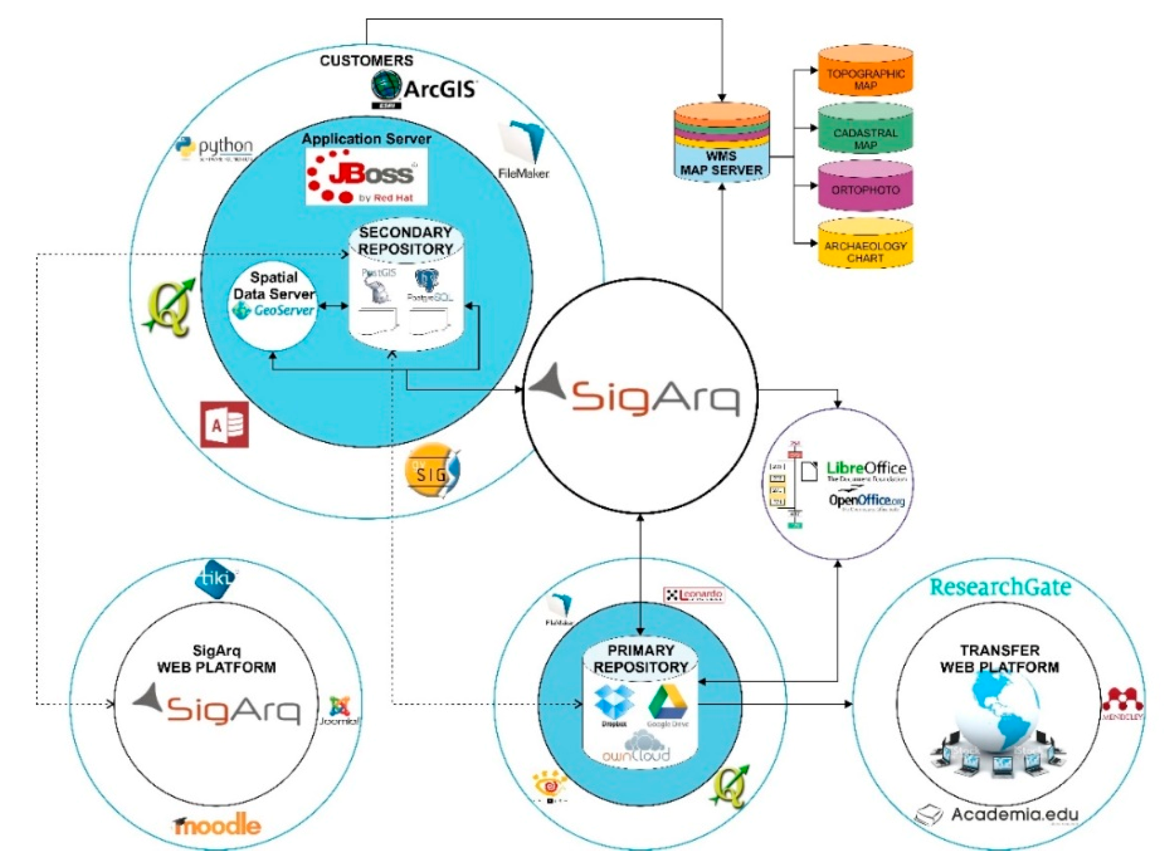
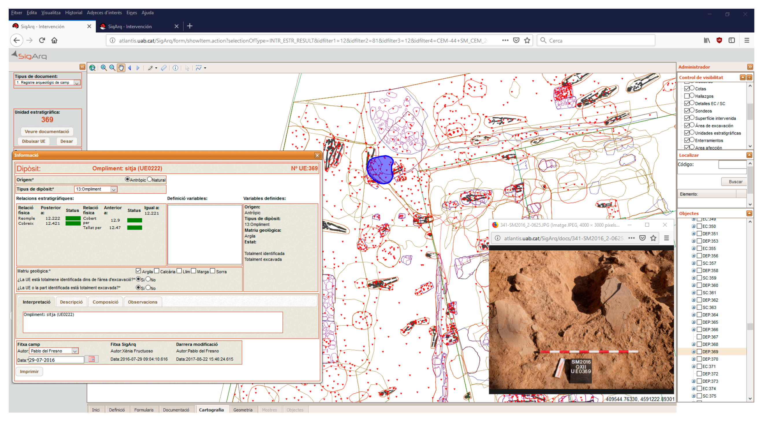
4.2. GIS and Archaeology. SigArq Tool Development

Nowadays, SigArq is an application still in transformation. It currently allows researchers to incorporate and manage excavation primary record, exploit these data and generate preliminary and final reports. Archaeological material databases are part of the ARIS but are not included in the application, since it currently is a GIS-based software. Data introduction takes five correlative steps that must be completed in order. Users are not allowed to skip any of these, as this would jeopardize the quality of the final record. These steps are:
  • US definition: US identification requires briefly defining what it is/was according to the materiality of the remains. A few examples of short definition are wall, filling, levelling layer, silo, pit, landslide, tomb, individual within a burial, etc.
  • Form Completion: Once the US is identified and defined, users are allowed to record US descriptive and temporal dimensions within a form. Although Description, Composition, and Interpretation are free-text entry input fields, fundamental attributes such as Origin or Type of US amongst others are single-choice input fields controlled through thesauri. Within the US form, the temporal dimension is introduced by means of recording the physical relation between the US under examination and those below. System crosscheck returns the relations with the US above and verifies the non-existence of contradictions in the stratigraphic sequence through a green-shaded status field. If contradictory data are introduced, they will be highlighted in red.
  • File uploading: General and detailed pictures of each US, identified with metadata—as shown in Table 2—and stored in the adequate ARIS-series, attest the US graphic dimension. In this step, one selected picture file is uploaded into the application together with an XYZ-coordinate capture table.
  • Cartography production: The cartographic dimension is the last item recorded within the system. The previously uploaded XYZ-table is now used to produce the plan and elevation, reproducing the cartography of the US within the general excavation plan.
  • US Metrics and exploitation: Like any SIG software, SigArq has some enabled geometric functions that calculate US total surface, point out distance and any other metrics desired for exploitation.
To sum up, archaeologists can interrogate all US dimensions in one single screen—as shown in Figure 7—after the record process is completed, and data are compared to the entire US assemblage for archaeological interpretation. These data being available from other software and platforms represented in Figure 5 above, data loading in previously designed templates produces US tables, Harris-Matrix diagrams and final reports easily and efficiently. The controlled process of data introduction ensures the quality and the traceability of the entire process. The result is a FAIR (findable, accessible, interoperable, and reusable) archaeological research, as claimed recently by European stakeholders [51].

5. Discussion: Past Construction through UT/US Dialectics

We have shown the building architecture of our ARIS and derived software application SigArq as a practical case of Research Information Systems for past construction. Still, we should discuss further implications of UT and US information units bearing in mind that SigArq is a US-built software according to Harris’ principles of archaeological stratigraphy [35]. It is worth insisting in the main issue to solve when combining archaeological data and information gathered from any other source: the need to define a common and exchangeable unit of information. As pointed out in Section 3, we can consider all US as UT. Despite this, the existence of four informative (descriptive, graphic, cartographic, and temporal) dimensions of a US is an ontological requirement for them to be, while UT can exist regardless of their materiality or the lack of it. From the ontological perspective, the UT exists as far as there is a vestige or reflection of the past informing about it, while the US needs the existence of an archaeological context.
Our contribution to an Integrated Construction of the Past lies upon the fact that, as far as—as archaeologists—we are in need of other sources of information for an accurate interpretation of material data, we have developed a code valid for Reflection construction with independence from the source. To that extent, UT/US reliability has to be evaluated, and the SigArq application contributes to monitoring the process of data gathering and exploitation in order to ensure its quality based upon rigorous and FAIR data collection, storage, and exploitation. This is ensured by the inclusion and use of standardized metadata for any single file produced during the research process, and it is guaranteed by the use of shareable platforms as those shown in Figure 5 [52].
Ontological differences between UT and US have to be considered, even though these do never compromise unit interoperability. Both of them are Units of Information (UI), data, evidences of the recent or remote past, for which a spatiotemporal context has to be provided in a precise or generic way. Place and time are essential ontological attributes in all cases regardless of the origin of the source—vestige or reflection—its materiality, the scientific discipline that produces it, the methodological specificities of data gathering, or the reliability of the information [29] (pp. 65–75). Table 3 summarizes the main differences and similarities between UT and US, which are mostly related to their materiality, and the possible relations with other UI for past construction such as Actors or Values, defined above.
As such UI, they are fully comparable, and together they shape the past construction. Their main difference is their materiality—essential for a US to be—and the consequences materiality has for the data gathering process. Other differences are concomitant to the relations that UT/US might or might not establish between them or with other UI. As stated in Section 3, the dichotomy between UT and US is a matter of scale and inclusion. US cannot include other US inside, but they can sum. The addition of US turns into a new unit of information originated as a reflection, and, therefore, it will necessarily be a UT. The interpretation process of material evidence leads unavoidably to the grouping of different US in Activities, Groups of Activities, or Phases according to the events occurred within a site identifiable through the archaeological record. Although we are content to use the terms proposed by A. Carandini [44] (p. 143) here, in the new scenario proposed, Activities, Groups of Activities, and Phases are equivalent to UT anyway.
These, registered from many other sources of information, can appear within every grade of this interpretational hierarchy of the archaeological record. Past construction then becomes completely interoperable and urgently interdisciplinary. As equivalent and comparable units, UT and US are part of the well-known Harris’ matrix diagram [35] (pp. 34–39) and, when exploited from knowledge bases, could be analyzed, exploited, and represented in terms of knowledge graph technology [53,54]. If considering, as L. Ehrlinger and W. Wöess did [55] (p. 3), that the Knowledge Graph acquires and integrates information into an ontology and applies a reasoner to derive new knowledge, the potential of our ontology-mediated data modeling could significantly increase.
The link between archaeology and other SSH, History in particular, is in no way unidirectional. Examples of UT identification from graphic vestiges (e.g., drawings or photographs) are fundamental for the interpretation of the archaeological record. Certainly, ancient photographs or other reflections —an archaeological diary with drawings made 40 or 50 years ago about a site no longer available for excavation—might inform about the material evidence of an action, regardless of whether an updated archaeological record according to the four dimensions of US is possible or not. This is demonstrated by UT identified in examples provided in Appendix B [56] (p. 154, Figure 4), as they offered a good correlation with the archaeological register built several decades after the pictures or notes were taken [57] (p. 147, Figure 3).
Finally, getting back to Thibodeau’s CPT, US as entities have one unique and specific class of involvement in events, which is Altered, since they are the material evidence—result or impact—of those events. Thibodeau’s distinction between Action and Event, being the first a specific class of the second, is considered as such in SigArq’s US record as well. The US description form considers their natural or anthropic origin as an attribute. Hence, the human character of an Actor’s role is attested even though it is impossible to identify it as a UI in the fieldwork. US of natural origin are then vestiges informing about events, and US of anthropic origin are the material evidence of actions.

6. Future Prospective

As long as this is an on-going project, we would like to outline the future potential and prospective of this approach instead of a set of fast-changing conclusions. In the framework of the so-called Digital Humanities, the chances offered by ICT for an integrated historical discourse have been our major concern for many years. Consequently, we designed a Research Information System built upon ontology-mediated data modeling. Throughout this paper, we summarized a methodological proposal for Past Construction in accordance with our perceptions of how historical discourses are originated and our scientific experience as archaeologists and historians, which we consider two inseparable categories of past-constructing scientists. The archaeological development of this research information system is an ARIS currently in use at different archaeological sites in Spain. The SigArq application as a quality-monitoring tool for data gathering and exploitation is a concomitant improvement towards the creation of ‘FAIRer’ reflections of constructed past.
Our self-awareness of being file generators when fulfilling our archaeological duties led us to search the principles for file classification and preservation in Records Management, in an effort to ensure the backwards traceability of research processes as one of the underpinning elements of scientific reliability. The definition of RIS in Historical Science requires another key element for making interdisciplinary collaboration possible: the use of a common and exchangeable code. Thus, we introduce our conceptualization of UT as a main Unit of Information obtainable from many different domains and sources, regardless of their vestige or reflection character and the nature of the science that provided them. This provides a shareable language for different domains in SSH focused in integrated Past Construction. The key advantage in using these UT and Ac concepts is that the problem of traditional fragmentation of SSH could be solved to some extent. The archaeological initiative of our data-modeling is also due to the high level of fragmentation of archaeological data and the traditionally limited capability for the collaborative research across boundaries, as already diagnosed the ARIADNE project’s partners [19] (p. 2).
Thibodeau’s CPT, as a germinal articulation of a challenging theoretical framework for past construction, moved us to review our in-progress data systematization and ontology creation. Precisely because the past is far more complex than what can be represented in any diagram [1] (p. 19), ontology-mediated data modeling revealed useful in interdisciplinary past constructions generated by the authors and their colleagues, but it needs a permanent revision of ontologies and terms in order to achieve a terminological consensus. It is time for SSH to get hands on past construction building reflections from an integrated perspective, taking advantage from electronic-supported devices, using ICT as a requirement for more ambitious research aims in History, and making Digital Humanities a term which becomes meaningful for Historical Science.

Author Contributions

Conceptualization, A.M.M.; Data curation, E.T.A.; Funding acquisition, E.T.A., P.d.F.B. and A.M.M.; Investigation, E.T.A.; Methodology, A.M.M.; Software, P.d.F.B.; Supervision, A.M.M.; Validation, P.d.F.B.; Visualization, P.d.F.B.; Writing—original draft, E.T.A.; Writing—review and editing, P.d.F.B. and A.M.M. All authors have read and agreed to the published version of the manuscript.

Funding

The Catalan Government (Generalitat de Catalunya) funded this research as part of an Archaeology and Paleontology 4-year-long research project (CLT009/18/00036—DGPC/exp. 35). The Town Council of Martorell generously contributes to the research project providing financial support as well. Research summarized in this paper also benefited from the FENIX/FENICE research project, funded by the Spanish Government [HAR2015-65285-R MINECO/FEDER, UE], and “La Caixa” Foundation (ID 100010434) under agreement 2017ACUP0195.

Acknowledgments

This study is part of the current research tasks carried out by the Medieval and Postmedieval Archaeology Research Group GRAMP.-UB (2017-SGR-833-GRC) of the University of Barcelona, to which all authors belong, and it is included in our Landscape Archaeology research line. The SigArq project is a collaborative endeavor including several partners and stakeholders. Amongst them, our colleagues of the Geographical Information and Remote Sensing Lab (UAB) and the Centre d’Estudis Martorellencs are deeply acknowledged. The authors wish to thank Ms Noemí Travé for language edition and review.

Conflicts of Interest

The authors declare no conflict of interest.

Appendix A

The following examples illustrate data identification and labeling of Units of Topography (UT), Actors (Ac), Values (V), Dates (D), Relationships (-), and Attributes (at) in two different written vestiges. Labels are indicated with this <symbol>. When a unit of information has different labels, they are separated by a comma. Example A1 is the written record of a vineyard purchase [58].
Example A1.
In nomine Domini. Ego <Ac1 Semplizia> et <Ac1-Ac2 sorori mea> nomine <Ac2 Cixolo>, nos simul in unum <Ac1-UT2, Ac2-UT2 uinditores> sumus tibi <Ac3 Guilara> <at-Ac3 presbiter> <Ac3-UT2 emptor>. Per hanc scriptura uindicionis nostre <UT1 uindimus> tibi <UT2 terra et uinea et arboribus et oliuaria>, hec omnia francum nostrum (pro)prium qui nobis aduenit, ad me <Ac1 Semplizia> per <Ac1-Ac* ienitores meos> et per compara et ad me <Ac2 Cixolo> per <Ac2-Ac* ienitores meos> et per ullasque uoces. Et est hec omnia in <UT3, UT3-UT4 comitatum Barquinona> infra <UT4, UT4-UT5 termine de Terracia> <UT5 in locum uocitatum Monte Agudo>. Afrontad <UT2 ipsa terra et uinea cum ipsos arboribus> qui ibi sunt fundatos <UT2-UT6, UT2-UT7 de oriente> in <UT6 aragallo> et in <UT7 terra> <Ac4-UT7, Ac5-UT7 de> <Ac4 Godmar> et <Ac5 suos eredes>, de <UT2-UT8 meridie> in <UT8 terra> <Ac6-UT8 de> <Ac6 Ego> <at-Ac6 femina>, <Ac6-Ac7 mulier de> <Ac7 Eruiio> <Ac8-UT8 et de> <Ac8 Guisado>, de <UT2-UT9, UT2-UT10 occiduo> in <UT9 uia> et in <UT10 terra> de <Ac3, AC3-UT10 te emptor>, de <UT2-UT11 circi> in <UT11 terra> de <Ac9, Ac9-UT11 Guisad>. Quantum istas afrontaciones includunt, sic uindimus tibi <UT2 ipsa terra el uinea et arboribus>, in ipso aragallo <UT12 ficulnea> I cum <UT13 pruneras> et <UT14 uides>, in alios locos prunera I et ficulneas II et <UT15 nogaria> et <UT16 pecera> et <UT17 glandifero> I et <UT18 oliuera> I ab integre cum exios et regresios earum ad tuum proprium propter precium <V1 solidos VI et denarios IIII ex moneda grossa>, quod manibus nostris accepimus et est manifestum, et de nostro iuro in tuo tradimus dominio et potestatem ad faciendum quod uolueris. Quod si nos uinditrices aut ullusque homo qui contra hanc ista carta uindicione uenerit pro inrumpendum aut nos uenerimus, non hoc ualead uindicare, set conponad aut conponamus tibi oc quod supra insertum est in duplo cum omnes illorum inmelioraciones, et in antea ista carta uindicione firma permanead omnique tempore.
Facta carta uindicione <D1 VI kalendas februarii anno XXII regnante Rodberto rege>.
<Ac1-UT19 Sig+num> <Ac1 Semplizia>. <Ac2-UT19 Sig+num> <Ac2 Cixolo>. Nos, qui hoc fecimus et firmare rogauimus. <Ac4-UT19 Sig+num> <Ac4 Godmar>. <Ac10-UT19 Sig+num> <Ac10 Mir>. <Ac11-UT19 Sig+num> <Ac11 Issarno>
SS. <Ac12 Ansemundo> <at-Ac12 presbiter> <Ac12-UT19 scripsit> cum literas superpositas in uerso V die et anno quod supra.
Example A2 is comprised of two consecutive paragraphs of a late medieval accounting book [59] (p. 298), property of merchant Joan de Torralba (Ac13). He registered the debts arising from the emission of letters of exchange, among many other transactions; in the Barcelonese headquarter of his company. The City of Barcelona is a previously known UT.
Example A2.
+ Ihesus + <D2 Mi CCCCXXXIIII. Divendres, a XXI de mag> (…) <UT20 Deuen> <Ac14 Anthoni de Paçi> e <Ac15 Francisco Tosingui> per <UT21 huna primera de cambi> de <Ac16 Còsimo> e <Ac17 Lorenço de Mèdici> feta en <UT22 Venècia> a <D3 XXIIII de abril>, <UT21 prometeren paguar> a <D4 LXV jorns ffeta> <V2 D ducats>, <UT23 rebuts> de <Ac18 Rubert Alibrandi> e <Ac19 Françesch Aloart>, que a rahó de <V3 XV sous V> fan a comte <V4 CCCLXXXV lliures VIII sous IIII>.
<D5 Dilluns, a XXIIII de mag>. <UT24 Deu> <Ac20 Johan Ventura> que m’acebtà <UT25 terza de cambi> de <Ac16 Còsimo> e <Ac17 Llorenço de Mèdici>, feta en <UT22 Venècia> a <D6 VIII d’abril>, <UT25 promes pagar> a <D7 LXV jorns feta> <V5 CC ducats>, a raó de <V3 XV sous V diners> per ducat, <UT26 rebuts> de <Ac18 Rubert Alibrandi> e <Ac19 Francesco Aloardi>, fan <V6 CLIIII lliures III sous IIII>.
Labeled data from both examples are included in a database. Main UT and Ac tables (Table A1 & Table A2) summarize the numbered observations identified for each class, and the relationships between both are shown as attributes of each. Table A1 shows Location and Date classes as attributes of the UT (See Figure 2 in the main text).
Table A1. Simplified UT dataset gathered from Examples A1 and A2.
VestigeUT IdUT Brief DescriptionRelationship(s) LocationBiotic AtAnthropic AtDate
Example A101PurchaseV1 (price) = UT05 Fact, transactionD1
Example A102Land, vineyard, trees Included in: UT05
Includes: UT12, 13, 14
Altered by UT01
= UT05 Property
Activity: farming
D1
Example A103County of BarcelonaIncludes: UT04Barcelona Landscape: Place nameD1
Example A104Municipality of TerrassaIncluded in: UT03
Includes: UT05
Terrassa Landscape: Place nameD1
Example A105Place MontagutIncluded in: UT04
Includes: UT2
UTM 31T
x: 41582;
y: 4599521
Landscape: Place nameD1
Example A106AregallDelimitation (E): UT02 = UT04 Landsc.: Place nameD1
Example A107LandDelimitation (E): UT02
Owned by: Ac04, 05
= UT04 PropertyD1
Example A108Land Delimitation (S): UT02
Owned by: Ac06
= UT04 PropertyD1
Example A109ViaDelimitation (W): UT02= UT04 Road network: viaD1
Example A110LandDelimitation (W): UT02
Owned by: Ac03
= UT04 PropertyD1
Example A111LandDelimitation (N): UT02
Owned by: Ac09
= UT04 PropertyD1
Example A112Fig treesAltered by: UT01= UT05Flora, Fig Activity: farmingD1
Example A113Plum treesAltered by: UT01= UT05Flora, PlumActivity: farmingD1
Example A114Vineyard Altered by: UT01= UT05Flora, VineActivity: Wine prod.D1
Example A115Walnut treesAltered by: UT01= UT05Flora, WalnutActivity: farmingD1
Example A116Fish farmAltered by: UT01= UT05Fauna, FishActivity: fish farmingD1
Example A117Acorn treesAltered by: UT01= UT05Flora, AcornActivity: farmingD1
Example A118Olive treesAltered by: UT01= UT05Flora, OliveActivity: Oil prod.D1
Example A119Purchase scriptureAltered by: UT01= UT05 Activity: ScriptureD1
Example A220DebtAc14&Ac15 to Ac13= UT27 Activity: transactionD2
Example A221First letter of exchangeAc14&Ac15 received from Ac16& Ac17= UT22 Activity: transactionD4
Example A222VeniceLocation UT21, 23, 25, 26Venice Activity: transactionD3
Example A223LoanAc18&Ac19 paid to Ac16& Ac17= UT22 Activity: transactionD3
Example A224DebtAc20 to Ac13= UT27 Activity: transactionD5
Example A225Third letter of exchangeAc20 received from Ac16& Ac17= UT22 Activity: transactionD7
Example A226LoanAc18&Ac19 paid to Ac16& Ac17= UT22 Activity: transactionD6
Example A227City of BarcelonaIncluded in: UT03Barcelona Landscape: Place nameD2&D5
Table A2. Simplified Ac dataset gathered from Examples A1 and A2.
VestigeAc IdNameJob GenderRelationship(s)
Example A101SempliziaunknownFemaleAc-UT: Seller UT02; Signature UT19/Ac-Ac: Sibling Ac02
Example A102Cixolo unknownFemaleAc-UT: Seller UT02; Signature UT19/Ac-Ac: Sibling Ac01
Example A103GuilaraPriestMaleAc-UT: Buyer UT02, Owner UT10
Example A104GodmarunknownMaleAc-UT: Owner UT07/Ac-Ac: Legacy to Ac05
Example A105Godmar’s Heirsunknown Ac-UT: Owner UT07/Ac-Ac: Heir of Ac04
Example A106EgounknownFemaleAc-UT: Owner UT09/Ac-Ac: Spouse Ac04
Example A107ErviiounknownMaleAc-Ac: Spouse Ac06
Example A108GuisadounknownMaleAc-UT: Owner UT09
Example A109GuisadunknownMaleAc-UT: Owner UT11
Example A110MirunknownMaleAc-UT: Witness UT01, Signature UT19
Example A111IssarnounknownMaleAc-UT: Witness UT01, Signature UT19
Example A112AnsemundoPriest, Scribe MaleAc-UT: Scribe UT19
Example A213Joan de TorralbaBoss Merchant MaleAc-UT: Indebted UT20, 24
Example A214Antonio de PazziMerchantMaleAC-UT: Debtor UT20, Indebted UT21
Example A215Francesco TosinghiMerchantMaleAC-UT: Debtor UT20, Indebted UT21
Example A216Cosme de MediciBankerMaleAC-UT: Debtor UT21, 25; Paid UT23, 26
Example A217Lorenzo de MediciBankerMaleAC-UT: Debtor UT21, 25; Paid UT23, 26
Example A218Roberto AldobrandiMerchantMaleAC-UT: Payer UT23, 26
Example A219Francesc AlvartMerchantMaleAC-UT: Payer UT23, 26
Example A220Giovanni VenturaMerchantMaleAC-UT: Debtor UT24, Indebted UT25
When UT, Ac, and their relations are properly identified, data exploitation and visualization have a great potential. Table A3 is a specific exploited dataset arising from Example A2. In this kind of documentation, economic relations are far more important than any other relationship and most of the texts follow the same template and record similar activities. Hence, transactions are a specific kind of UT in which two or more Ac are related through money exchange, usually using different coins. Within this table, only transaction UT are shown with all the relations implied.
Table A3. Specific transaction dataset built upon the relationship between Actors, UT, Date, and Values obtained from Example A2.
TypeDateActive Ac Object Passive Ac PriceLocation
UT20 - DebtD2 - 1434/05/21Ac14 - A. de PazziUT21 Ac13 - J. TorralbaV4 - 385lb 8sb 4db*UT27 - Barcelona
UT20 - DebtD2 - 1434/05/21Ac15 - F. TosinghiUT21Ac13 - J. TorralbaV4 - 385lb 8sb 4dbUT27 - Barcelona
UT21 - LetterD4 - 1434/06/29Ac16 - C. MedicinoneAc14 - A. de PazziV2 - 500 du.UT22 - Venice
UT21 - LetterD4 - 1434/06/29Ac17 - L. MedicinoneAc15 - F. TosinghiV2 - 500 du.UT22 - Venice
UT21 - LetterD4 - 1434/06/29Ac17 - L. MedicinoneAc14 - A. de PazziV2 - 500 du.UT22 - Venice
UT21 - LetterD4 - 1434/06/29Ac16 - C. MedicinoneAc15 - F. TosinghiV2 - 500 du.UT22 - Venice
UT23 - LoanD3 - 1434/04/24Ac18 - R. AldobrandiUT21Ac17 - L. MediciV2 - 500 du.UT22 - Venice
UT23 - LoanD3 - 1434/04/24Ac18 - R. AldobrandiUT21Ac16 - C. MediciV2 - 500 du.UT22 - Venice
UT23 - LoanD3 - 1434/04/24Ac19 - F. AlvartUT21Ac16 - C. MediciV2 - 500 du.UT22 - Venice
UT23 - LoanD3 - 1434/04/24Ac19 - F. AlvartUT21Ac17 - L. MediciV2 - 500 du.UT22 - Venice
UT24 - DebtD5 - 1434/05/24Ac20 - G. VenturaUT25 Ac13 - J. TorralbaV6 - 154lb 3sb 4dbUT27 - Barcelona
UT25 - LetterD7 - 1434/08/18Ac16 - C. MedicinoneAc20 - G. VenturaV5 - 200 du.UT22 - Venice
UT25 - LetterD7 - 1434/08/18Ac17 - L. MedicinoneAc20 - G. VenturaV5 - 200 du.UT22 - Venice
UT26 - LoanD6 - 1434/04/08Ac18 - R. AldobrandiUT25Ac17 - L. MediciV5 - 200 du.UT22 - Venice
UT26 - LoanD6 - 1434/04/08Ac18 - R. AldobrandiUT25Ac16 - C. MediciV5 - 200 du.UT22 - Venice
UT26 - LoanD6 - 1434/04/08Ac19 - F. AlvartUT25Ac16 - C. MediciV5 - 200 du.UT22 - Venice
UT26 - LoanD6 - 1434/04/08Ac19 - F. AlvartUT25Ac17 - L. MediciV5 - 200 du.UT22 - Venice
* Notice that V3 is an exchange value, and that V2 ∗ V3 = V4, and V5 ∗ V3 = V6.

Appendix B

Data labeling is only possible in written sources. These might be the richer ones in Actor, Value, or absolute Date information. Notwithstanding this fact, Units of Topography as evidences of events are available and identifiable in many other material and non-material vestiges. This appendix provides examples of graphic vestiges and their subsequent UT identification.
Example A3.
Is a picture [60] of Sant Llorenç de la Senabre (Santa Margarida i els Monjos, Barcelona, Spain), a Romanesque church reused as a farm in the 19th Century AD. This picture in Figure A1a was taken in 1912 prior to the collapse and abandonment of the structure. As a vestige, it was a valuable source of data to interpret the later vestiges in 2011 and the following years, when the archaeological record was built. Figure A1b illustrates the identification of US during the archaeological survey in 2011. The north side of the apse was transformed into a domestic oven. This hypothesis that arose from the survey was confirmed during the excavation in 2012, and the oven was later restored in 2016. Figure A2 illustrates the fieldwork results.
Figure A1. Sant Llorenç de la Senabre in 1912 (a) and 2011 (b). UT and US are identified through image processing and illustration software. US identification is possible in vestiges remaining in the present. Disappeared walls and annex structures have to be considered as UT.
Information 11 00182 g0a1
Figure A2. Sant Llorenç de la Senabre’s domestic oven after the completion of the excavation in 2012 (a) and its restoration in 2016 (b).
Information 11 00182 g0a2
Example A4.
Is a drawing from the 17th Century AD that illustrates the town of Martorell watched from the west side of river Anoia. The artist—Pier Maria Baldi—illustrated in watercolor some elements of the material heritage currently disappeared during a journey along Spain and Portugal that he made in Cosme de Medici’s company [61]. Figure A3 shows the original picture together with a labeled version of it.
Figure A3. Pier Maria Baldi’s drawing of Martorell in the 17th Century <UT. UT are identified and labeled accordingly.
Information 11 00182 g0a3
Example A5.
Is a protograph of schoolchildren and their teacher [62]. This kind of pictures usually inform about several UT and Ac, though the analyst is not always able to identify all the actors or places represented. We could only identify the teacher in this example, despite many other actors being present. Figure A4 shows UT and Ac labelling on the picture.
Figure A4. Schoolchildren from the Company Guarro Casas’ School, taken in Gelida (Catalonia, Spain) in 1927. UT are labeled directly onto the picture (a) while Ac are labeled in a separate sketch for the sake of clarity (b). We edited the original picture by means of image processing and illustration software.
Information 11 00182 g0a4
According to the examples in Appendix B, a summary dataset obtained from UT and Ac identification on graphic vestiges are provided in Table A4 and Table A5. Actor identification is not possible in Example A3.
Table A4. Simplified UT dataset gathered from Examples A3, A4, and A5.
VestigeUT IdUT Brief DescriptionRelationship(s) LocationBiotic AtAnthropic AttributesDate
Example A328Lombard bandsAttached to UT34= UT34 Construction: Decoration1912 AD
Example A329Annexe buildingAttached to UT34= UT34 Construction: Structure1912 AD
Example A330Annexe building: Domestic ovenAttached to UT34= UT34 Construction: Structure1912 AD
Example A331Chimney Affects UT34= UT34 Construction: Structure1912 AD
Example A332Apse roofOnto UT34= UT34 Construction: Structure1912 AD
Example A333Nave roofOnto UT34= UT34 Construction: Structure1912 AD
Example A334Sant Llorenç de la Senabre Romanesque churchBeneath: UT32, 33
Affected by: UT34
UT28, 29, 30 are attached
Santa Margarida i els Monjos (Barcelona, Spain) Construction: Structure11th Cent AD
Example A435MartorellIncludes: UT37, 38, 39, 40, 41 Martorell (Catalonia, Spain) Landscape: Place name1668 AD
Example A436River AnoiaPasses by: UT35 = UT35Watercourse 1668 AD
Example A437Bridge on the river AnoiaAffects: UT36
Included in: UT35
= UT35 Construction: Structure1668 AD
Example A438Anoia’s GateIncluded in: UT35= UT35 Construction: Structure1668 AD
Example A439Church of Saint MaryIncluded in: UT35= UT35 Construction: Structure1668 AD
Example A440Medieval WallIncluded in: UT35= UT35 Construction: Structure1668 AD
Example A441Town BuildingsIncluded in: UT35= UT35 Construction: Structure1668 AD
Example A442Royal Pathway Passes by: UT35 = UT35 Landscape: Road1668 AD
Example A543Company Guarro Casas’ SchoolIncluded in: UT47
Includes: UT45
Linked to: UT44, UT46
Engaged Ac21
= UT47 Activity: teaching1927 AD
Example A544Old Mill BuildingLinked to: UT43 = UT47 Construction: Structure1927 AD
Example A545Teaching courseIncluded in: UT43
Performed by Ac21
= UT47 Activity: teaching1927 AD
Example A546Company Guarro CasasLinked to: UT43= UT47 Activity: paper production1927 AD
Example A547GelidaIncludes: UT43 Gelida (Catalonia, Spain) Landscape: Place name1927 AD
Table A5. Simplified Ac dataset gathered from Examples A3, A4, and A5.
VestigeAc IdNameJob GenderRelationship(s)
Example A3-unknownunknownMaleunknown
Example A521Josep Maria RoigSchool teacherMaleAc-UT: Performs UT45; Ac-Ac: Teaches unknown Ac
Example A5-unknownunknownMaleAc-UT: Attends to UT45; Ac-Ac: Student of Ac21
Example A5-unknownunknownFemaleAc-UT: Attends to UT45; Ac-Ac: Student of Ac21

References

  1. Thibodeau, K. The Construction of the Past: Towards a Theory for Knowing the Past. Information 2019, 10, 332. [Google Scholar] [CrossRef] [Green Version]
  2. Shanks, M. Symmetrical Archaeology. World Archaeol. 2007, 39, 589–596. [Google Scholar] [CrossRef]
  3. López-Poza, S.; Algunas Reflexiones Sobre los Humanistas Digitales en España. In Humanidades Digitales Hispánicas. Available online: http://humanidadesdigitaleshispanicas.es/contribuciones/algunas-reflexiones-sobre-loshumanistas-digitales-en-españa/ (accessed on 1 March 2019).
  4. Martinón-Torres, M.; Killick, D.J. Archaeological theories and archaeological sciences. In Oxford Handbook of Archaeological Theory; Gardner, A., Lake, M., Sommer, U., Eds.; Oxford University Press: Oxford, UK, 2016; pp. 1–17. [Google Scholar]
  5. Hodder, I. The Entanglements of Humans and Things: A long-term view. New Lit. Hist. 2014, 45, 19–36. [Google Scholar] [CrossRef]
  6. Hicks, D. The material-cultural turn: Event and effect. In The Oxford Handbook of Material Culture Studies; Hicks, D., Beaudry, M.C., Eds.; Oxford University Press: Oxford, UK, 2010; pp. 25–98. [Google Scholar]
  7. Barceló, M. Arquelogia Medieval. En las Afueras del “Medievalismo”; Editorial Crítica: Barcelona, Spain, 1988. [Google Scholar]
  8. Zadora-Río, E. Le village des historiens et le village des archéologues. In Campagnes Médiévales. L’homme et son Espace. Études Offertes à Robert Fossier; Mornet, E., Ed.; Publications de la Sorbonne: París, France, 1995; pp. 145–153. [Google Scholar]
  9. Quirós-Castillo, J.A. Las Aldeas de los Historiadores y las Aldeas de los Arqueólogos en el Nordeste Peninsular. Territ. Soc. Poder 2007, 2, 65–86. [Google Scholar]
  10. Mauri, A.; Travé, E.; Del Fresno, P. An Integrated Implementation of Written and Material Sources–Conceptual Challenge and Technological Resources. In Archaeology. New Approaches in Theory and Techniques; Ollich, I., Ed.; InTech: Rijeka, Croatia, 2012; pp. 41–64. [Google Scholar]
  11. Witmore, C. The realities of the past: Archaeology, Object-Orientations, Pragmatology. In Modern Materials, Proceedings of the Contemporary and Historical Archaeology in Theory Conference, Oxford, UK, 2009; Fortenberry, B., McAtackney, L., Eds.; Archaeopress BAR International Series: Oxford, UK, 2012; pp. 25–36. [Google Scholar]
  12. Amati, V.; Munson, J.; Scholnick, J.; Habiba. Applying event history analysis to explain the diffusion of innovations in archaeological networks. J. Archaeol. Sci. 2019, 104, 1–9. [Google Scholar] [CrossRef]
  13. Mosca, A.; Rondelli, B.; Rull, G. The OBDA-Based ‘Observatory of Research and Innovation’ of the Tuscany Region. In Proceedings of the Joint Ontology Workshops 2017 (JOWO 2017), Episode 3: The Tyrolean Autumn of Ontology, Bozen-Bolzano, Italy, 21–23 September 2017. [Google Scholar]
  14. Mosca, A. Ontology-mediated Data Integration and Access in Research and Innovation Policy. In Proceedings of the Joint Ontology Workshops 2017 (JOWO 2017), Episode 3: The Tyrolean Autumn of Ontology, Bozen-Bolzano, Italy, 21–23 September 2017. [Google Scholar]
  15. Hodder, I.; Orton, C. Spatial Analysis in Archaeology; Cambridge University Press: Cambridge, UK, 1976. [Google Scholar]
  16. Interpreting Transformations of People and Landscapes in Late Antiquity and Early Middle Ages. In Archaeological Approaches and Issues; Diarte-Blasco, P.; Christie, N. (Eds.) Oxbow: Oxford, UK; Philadelphia, PA, USA, 2018. [Google Scholar]
  17. La Caracterització del Paisatge Històric; Bolós, J. (Ed.) Universitat de Lleida: Lleida, Spain, 2010. [Google Scholar]
  18. Krauwer, S. The Parthenos Project. In Proceedings of the Parthenos CEE Workshop, Sofia, Bulgaria, 7–9 October 2019. [Google Scholar]
  19. Meghini, C.; Scopigno, R.; Richards, J.; Wright, H.; Geser, G.; Cuy, S.; Fihn, J.; Fanini, B.; Hollander, H.; Niccolucci, F.; et al. ARIADNE: A research infrastructure for archaeology. ACM J. Comput. Cult. Herit. 2017, 10, 1–27. [Google Scholar] [CrossRef] [Green Version]
  20. Yeo, G. The Conceptual Fonds and the Physical Collection. Archivaria 2012, 73, 43–80. [Google Scholar]
  21. Nesmith, T. Reopening Archives: Bringing New Contextualities into Archival Theory and Practice. Archivaria 2006, 60, 259–274. [Google Scholar]
  22. González-Pérez, C. A Conceptual Modeling Language for the Humanities and Social Sciences. In Proceedings of the Sixth International Conference on Research Challenges in Information Science (RCIS), Valencia, Spain, 16–17 May 2012. [Google Scholar]
  23. Gänser, G.; Michetti, G. InterPARES Trust Project. Ontology of Functional Activities for Archival Systems. TR05-Final Report-20180526. 2018. Available online: https://interparestrust.org (accessed on 16 March 2020).
  24. Mauri, A. Sistemes Territorials i L’estudi de les Traces Arqueològiques Medievals. Un Exemple D’aplicació a L’antiga Baronia de Castellvell de Rosanes (Baix Llobregat, Barcelona). Master’s Thesis, Universitat de Barcelona, Barcelona, Spain, 1997. [Google Scholar]
  25. Mauri, A. La Configuració del Paisatge Medieval: El Comtat de Barcelona Fins al Segle XI. Ph.D. Thesis, Universitat de Barcelona, Barcelona, Spain, 2006. [Google Scholar]
  26. Ivanovs, A.; Varfolomeyev, A. Editing an exploratory analysis of medieval documents bu means of XML technologies’. Humanit. Comput. Cult. Herit. 2005, 155, 155–160. [Google Scholar]
  27. de Jong, F.; Rode, H.; Hiemstra, D. Temporal language models for the disclosure of historical text. In Humanities, Computers and Cultural Heritage, Proceedings of the XVI International Conference of the Association for History and Computing; Koninklijke Nederlandse Academie van Wetenschappen: Amsterdam, The Netherlands, 2005; pp. 161–168. [Google Scholar]
  28. Mauri, A.; Travé, E.; Del Fresno, P. Research Information System (RIS): General principles and applications for Information Management. In Proceedings of the Open Science & the Humanities Conference, Barcelona, Spain, 21 June 2018. [Google Scholar]
  29. Del Fresno, P. Sistema de Información Arqueológica: Propuesta de Normalización, Desarrollo Conceptual e Informático. Ph.D. Thesis, Euskal Herriko Unibertsitatea–Universidad del País Vasco, Vitoria, Spain, 2016. [Google Scholar]
  30. Del Fresno, P.; Travé, E.; Mauri, A. Archaeological Research Information System (ARIS): Information and Stratigraphic Register Management. In Proceedings of the Open Science & the Humanities Conference, Barcelona, Spain, 21 June 2018. [Google Scholar]
  31. Travé, E.; López, M.D.; Casado, I.; Álvaro, K.; Marí, G. Research Information System (RIS): Study case for mercantile societies through the FENIX database. In Proceedings of the Open Science & the Humanities Conference, Barcelona, Spain, 21 June 2018. [Google Scholar]
  32. Travé, E.; Casado, I. Herramientas para el análisis contable de documentación mercantil bajomedieval: Perspectiva ontológica y gestión integrada de datos. In Actas del Congreso Mercados y Espacios Económicos en el Siglo XV. El Mundo del Mercader Torralba; López, M.D., Ed.; Publicacions de la Universitat de Barcelona: Barcelona, Spain, 2020. [Google Scholar]
  33. Arostegui, J. La Investigación Histórica: Teoría y Método; Crítica: Barcelona, Spain, 1995. [Google Scholar]
  34. Wickham, H. Tidy Data. J. Stat. Softw. 2014, 59, 1–23. [Google Scholar] [CrossRef] [Green Version]
  35. Harris, E.C. Principles of Archaeological Stratigraphy; Academic Press Inc.: San Diego, CA, USA, 1989. [Google Scholar]
  36. Gerritsen, A.; Riello, G. Introduction. Writing Material Culture History. In Writing Material Culture History; Gerritsen, A., Riello, G., Eds.; Bloomsbury Academic: London, UK, 2015; pp. 1–13. [Google Scholar]
  37. Johnson, T. Legal History and the Material Turn. In The Oxford Handbook of Legal History; Dubber, M.D., Tomlins, C.H., Eds.; University of Oxford: Oxford, UK, 2018; pp. 1–18. [Google Scholar] [CrossRef]
  38. Schouwenburg, H. Back to the Future? History, Material Culture and New Materialism. Hist. Cult. Mod. 2015, 3, 59–72. [Google Scholar] [CrossRef] [Green Version]
  39. Trentmann, F. Materiality in the Future of History: Things, Practices and Politics. J. Br. Stud. 2009, 48, 283–307. [Google Scholar] [CrossRef] [Green Version]
  40. Cosgrove, D. Landscape and Landschaft. Lecture delivered at the “Spatial Turn in History” Symposium. Ger. Hist. Inst. Bull. 2004, 35, 57–71. [Google Scholar]
  41. Graves, M.; Teulié, G. Histories of Space, Spaces of History–Introduction. E-rea Rev. Électron. D’études Monde Angloph. 2017, 14. Available online: http://erea.revues.org75878 (accessed on 28 March 2020).
  42. Torre, A. Un «tournant spatial» en histoire? Paysages, regards, ressources. Ann. Hist. Sci. Soc. 2008, 2008, 1127–1144. [Google Scholar]
  43. White, R. What is Spatial History? In Spatial History Lab: Working Paper; Standford University: Stanford, CA, USA, 2010. [Google Scholar]
  44. Carandini, A. Historias en la Tierra: Manual de Excavación Arqueológica; Crítica: Barcelona, Spain, 1997. [Google Scholar]
  45. SigArq. Sistema de Información Geoespacial Arqueológico. Available online: http://www.sigarq.es/home/ (accessed on 9 December 2019).
  46. Soler, M. Feudalisme i nucleació poblacional. Processos de concentració de l’habitat al comtat de Barcelona entre els segles X i XIII. Acta Hist. Archeol. Med. 2002, 2002, 69–101. [Google Scholar]
  47. Travé, E. Los hornos medievales y la cerámica negra. In Actas del XIX Congreso de la Asociación de Ceramología. Obra Negra y Alfarería de Cocina; Asociación de Ceramología/Ajuntament de Quart: Quart, Spain, 2017; pp. 123–147. [Google Scholar]
  48. Information and Documentation—Work Process Analysis for Records; ISO/TR 26122; ISO: Geneva, Switzerland, 2008.
  49. Information and Documentation—Records Management—Part 1: Concepts and Principles; ISO 15489-1; ISO: Geneva, Switzerland, 2016.
  50. International Council on Archives. ISAD(G) (General International Standard Archival Description) Norma Internacional General de Descripció ARXIVÍSTICA; Associació d’Arxivers de Catalunya/Generalitat de Catalunya Departament de Cultura: Barcelona, Spain, 2001. [Google Scholar]
  51. Wilkinson, M.D. The FAIR Guiding Principles for scientific data management and stewardship. Sci. Data 2016, 3, 160018. [Google Scholar] [CrossRef] [Green Version]
  52. Parthenos. Guidelines to FAIRify Data Management and Make Data Reusable. Available online: https://zenodo.org/record/2668479 (accessed on 16 March 2020).
  53. Yan, J.; Wang, C.H.; Cheng, W.; Gao, M.; Zhow, A. A retrospective of Knowledge Graphs. Front. Comput. Sci. 2018, 12, 55–74. [Google Scholar] [CrossRef]
  54. Manrique, R.; Pereira, B.; Mariño, O. Exploring knowledge graphs for the identification of concept prerequisites. Smart Learn. Environ. 2019, 6, 21. [Google Scholar] [CrossRef] [Green Version]
  55. Ehrlinger, L.; Wöess, W. Towards a Definition of Knowledge Graphs. Conference Paper. SEMANTiCS 2016, 48, 1–5. [Google Scholar]
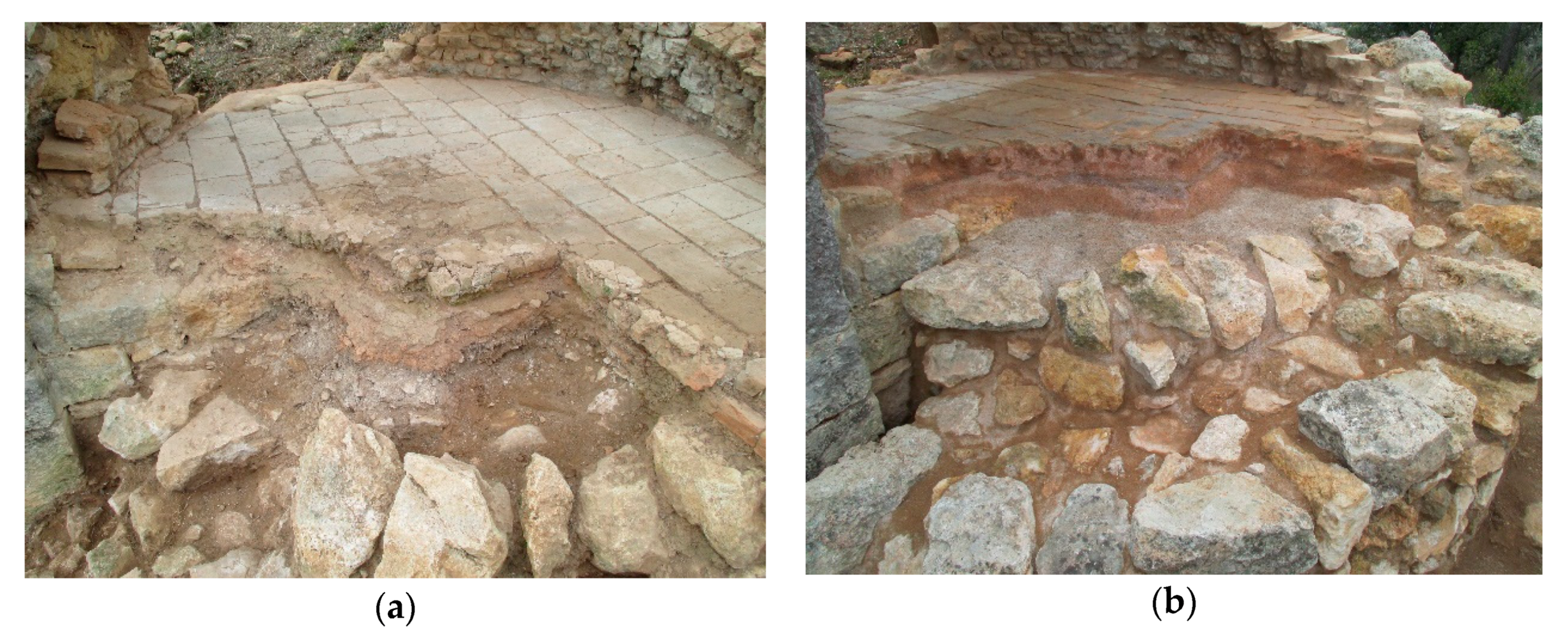
  56. Mauri, A.; Travé, E.; Del Fresno, P. Estudi preliminar de l’ermita de Sant Llorenç de la Senabre. Santa Margarida i els Monjos (Alt Penedès). In III Monografies del Foix; Diputació de Barcelona: Barcelona, Spain, 2013; pp. 150–157. [Google Scholar]
  57. Del Fresno, P.; Socorregut, J. Conèixer, gestionar i difondre: El forn de l’ermita de Sant Llorenç de la Senabre. Santa Margarida i els Monjos (Alt Penedès). In IV Trobada d’estudiosos del Foix; Diputació de Barcelona: Barcelona, Spain, 2017; pp. 144–153. [Google Scholar]
  58. Puig, P. El monestir de Sant Llorenç del Munt Sobre Terrassa. Diplomatari dels Segles X i XI. Volum I; Fundació Noguera: Barcelona, Spain, 1995. [Google Scholar]
  59. ANC1-690-T-721, f8v. Edited by Benavides, J. Para una Historia de las Sociedades Mercantiles Catalanas. Estudio Completo del “Dietari Honzè” de la Compañía Torralba (10 de mayo del 1434–Agosto del 1437). Ph.D. Thesis, Universitat de Barcelona, Barcelona, Spain, 2017.
  60. Vidal, E. La conca del riu Foix i sos principals afluents. Butll. Centre Excursion. Catalunya 1912, 206, 65–79. [Google Scholar]
  61. Magalotti, L. Viaje de Cosme de Médicis por España y Portugal (1668–1669); Sanchez Rivero, A., Mariutti, A., Eds.; Sucesores de Rivadeneyra: Madrid, Spain, 1933. [Google Scholar]
  62. Vinyes, J.M.; Carafí, E.; Rovira, R. Guarro Casas. 300 anys D’història. 1698–1998; Guarro Casas: Barcelona, Spain, 1998; p. 102. [Google Scholar]
Figure 1. Summary view of Constructed Past Theory (CPT) according to K. Thibodeau [1] expressed as a UML diagram. Highlighted classes in purple and green are those related to our concepts of ‘Units of Topography’ and ‘Actors’, respectively, as further developed in our research domain. Extra detail will be provided in Section 3. Classes highlighted in orange are those in which these conceptual modeling has been applied.
Information 11 00182 g001
Figure 2. UML diagram expressing the minimum information units of historical knowledge as components of Vestige. This conceptual modeling fits well within Thibodeau’s CPT, whose classes are highlighted in red. Our further concept development is highlighted in purple for UT, green for Ac and orange for relational classes.
Information 11 00182 g002
Figure 3. Exchangeable information management scheme. Different disciplines—regardless of whether they share the SSH domain or not—have their own research methods, which are comparable as long as they share minimum information units (a). When this happens, a new interdisciplinary scenario allows the common use and exploitation of both vestiges and reflections according to archaeology (b).
Information 11 00182 g003
Figure 4. Model of integrated information that illustrates US–UT correlation. Notice that bottom level includes a subclass of US registered as details of the US. Although further thoughts on this will be provided in the discussion section, each row in the graphic represents a same-scale zoom on landscape analysis and how different US are part of the material vestige of a single UT.
Information 11 00182 g004
Figure 5. General design of SigArq ARIS as a system of subsystems. Different software can address and exploit text, graphic, cartographic, and relational data contained in linked repositories in order to produce reports and files used as a reflection of Constructed Past.
Information 11 00182 g005
Figure 6. Classification chart of series, folders and files of the ARIS according to the main diagnosed processes of information management.
Information 11 00182 g006
Figure 7. SigArq screen-view. At the end of the data recording process—as per US 369 in this figure—all four informative dimensions can be displayed at once for further exploitation.
Information 11 00182 g007
Table 1. Primary management of archaeological record. Item file classification and storage.
ARIS
FunctionActivityFileItem
4000-Raw Data4200-Graphic Data4201-US/B Photographs .jpg 4201-XXXAAAA-000N.FFF 1
4202-ArchMaterial Photographs4202-XXXAAAA-000N.FFF
4203-Report Photographs4203-XXXAAAA-000N.FFF
[…][…]
Where: 4201 is a unique correlative number to identify the composite file within the folder; - XXXAAAA is an expression of the site (XXX) and year of campaign (AAAA); - 000N is a sequential numeration for each simple file within the composite file; - FFF is the normalized expression of file digital format (Example: 4201-SGR2014-0001.JPG identifies the first US field picture taken in Sant Genís de Rocafort (Martorell, Barcelona) during the fieldwork season in 2014.)
Table 2. File description and secondary assessment through metadata introduction 1.
GroupFieldCharacter 2Indications for Users and Format
LegendTitleO Picture caption describing the content: <text>
Special instructionsO Instructions for further processing or considerations to take into account (e.g., labeling mistakes if any): <text>
Key wordsKey wordsCGArchaeological site ID expression: <AAA>
CGYear of fieldwork campaign: <0000>
CGTrench: <III>
CSUS ID number: <US0000>
CSBurial ID number: <B000>
CSAFor pictures with plan indications: <photopla>
CSAFor drone-obtained aerial views: <photodrone>
CSAFor SigArq uploading (one per US): <photoSig>
CSA[…]
CreditsAuthorO <Surname(s), Name>; <ORCID>
OriginCG<Institution or Company Name>
CopyrightCGCC (by-nc-sa)
ContactCG<e-mail address>
Date/TimeCreation dateCG<yyyy/mm/dd>
OriginCityCG<City name>
LocationCG<Location name>
State/provinceCG<State/province name>
CountryCG<Country name>
1 Metadata schema shown in this table follows the normalized IPTC by XnView open software; 2 Character indicates whether the metadata are of compulsory (C) or optional (O) introduction, and the specific character of the compulsory descriptive information contained: General (G), Specific (S) or referred to Secondary Assessment (SA).
Table 3. Units of information (US/UT) ontological summary.
AttributeUSUT
Source of obtentionMaterialWritten, material, visual, sound
MaterialityEssentialNon-essential
Informative dimensions:
• SPATIALEssentialEssential
• DescriptiveEssentialEssential
• GraphicEssentialNon-essential
• CartographicEssentialNon-essential
• TEMPORALEssentialEssential
Possible relations:
• US-US/UT-UTPhysical contactInclusion, delimitation, link
• Ac-US/Ac-UTNon-possible 1Non-essential
• US-UTUS = UT
US + US = UT
US = UT
UT + UT = UT
Involvement in eventEssential (altered)Non-essential
1 The material register does not inform about Ac.

