Article

Insularity and Religious Life: The Case of Hellenistic Ikaros/Failaka Island

Independent Researcher, 16672 Athens, Greece
Religions 2021, 12(11), 1002; https://doi.org/10.3390/rel12111002
Submission received: 29 August 2021 / Revised: 7 November 2021 / Accepted: 11 November 2021 / Published: 15 November 2021

Abstract

:
This paper explores the notion of insularity and religious life in the sacred landscape of Ikaros/Failaka with a particular focus on the Hellenistic period. The little island of Ikaros/Failaka in the Persian Gulf had a long pre-Hellenistic religious history and was occupied by Alexander, explored by his officials and became part of the Seleucid kingdom. From the mid-20th century, archaeological missions working on the nesiotic space of the Persian Gulf have revealed material evidence that has altered our view of this remote part of the Hellenistic world. Research revealed a flourishing network of cultural communication and contacts between the indigenous population of the East and Greco-Macedonians. These interactions mirror the landscape of the Hellenistic East. Thus Ikaros/Failaka, an island on the periphery of the Seleucid kingdom, situated at a strategic point (near the mouth of the River Euphrates and close to the shores of the Persian Gulf) appears to be part of a chain of locations that possessed political/military, economic, and religious importance for the Seleucids. It became a fruitful landscape, where the Seleucids pursued their political and religious agenda.

1. Introduction

In recent times, the matter of insularity and insular landscapes has become an important issue in the study of Mediterranean islands. Many theoretical approaches have attempted to define the notion of insularity, which has led to a range of interpretations. When investigating the concept of insularity, one must bear in mind that insularity is not static. It changes over time in relation to long-term spatial features (such as geography and topography) and temporal factors (such as tradition, culture, human activities, intentional or unintentional, and relationships) (Braudel 1972; Broodbank 2000, pp. 10, 19, 22–23). Insularity is influenced by many parameters and is thus open to multiple interpretations. Knapp (2008, pp. 31–35), when stressing the complex nature of insularity, notes that it covers a wide range of states, from complete isolation to complete connectivity. In mentioning the parameters involved in the notion of insularity, he notes that ‘insularity is contingent on both space and time, and thus may be adopted or adapted as individuals or wider social concerns dictate’ (p. 18). Decisions by individuals or policies of central administrations, conscious or unconscious actions, behaviors and ideologies, local identities and beliefs create a fruitful environment where insularity is defined or redefined according to circumstances. Thus, insularity is a relative concept, ‘… culturally constructed, open to multiple meanings in a given context, historically contingent, and therefore liable to change’ and ‘contingent in both space and time’ (Broodbank 2000, pp. 17–18, 22–23).
Using the theoretical approaches involved in insularity, in combination with literary sources, historical narratives and archaeological discoveries, scholars have reinterpreted the insular landscapes of the Mediterranean as spaces where human activity is characterised by the interplay of many internal and external factors. The islands’ geographical location and environment, their natural resources, their local identities, traditions, beliefs and practices in combination with political and economic circumstances created within the Mediterranean a network of vibrant geo-historical and geo-political entities that interacted over time and space (Broodbank 2000, pp. 22–23). Moreover, as Horden and Purcell (2000) argue in The Corrupting Sea, the Mediterranean is characterised by a geographical and regional fragmentation that led to the increase in maritime connectivity, which therefore made the Mediterranean an interconnected world.
But does this also occur outside the Mediterranean, in the nesiotic space of the Persian Gulf? How might the notion of insularity apply to the islands of the Persian Gulf and in particular to Ikaros/Failaka island? In Kosmin’s (2013, p. 68) view ‘the Arab/Persian Gulf, much like the Mediterranean, should be regarded as an environmental and (consequently) geopolitical entity’. The islands of the Persian Gulf can be considered as geo-historical entities, as part of a long-term history in which their populations increase, mingle, move or decline as a consequence of broader historical developments (Brughmans 2013). Our knowledge of the unique character of the islands of the Persian Gulf has grown thanks to the archaeological discoveries of the mid-20th century. From the 1950s onwards, a series of Danish archaeological missions worked on three islands of the Persian Gulf, Ikaros/Failaka (north), Tylos/Bahrain (center) and Umm an-Nar (south) (Figure 1). Their work has generated new perspectives in the study of this area (Potts 2016, p. 109). Moreover, the continuous systematic excavations in the Persian Gulf by American, Italian, French, Greek, Kuwaiti and Slovak archaeological missions, among others, have revealed a vibrant maritime and land network that, from the Bronze Age onwards, spread from Mesopotamia, southern Iran, the Persian Gulf, the Arabian Peninsula and the Indus Valley (Potts 2016, pp. 29–31, 109–10; Hannestad 2019, pp. 314–15; Kosmin 2013).
Although the islands of the Persian Gulf formed distinct geographical entities, they lacked political autonomy. They were influenced by major civilisations, such as those of Magan and Dilmun, and of empires, such as those of the Assyrians, the Neo-Babylonians, the Achaemenids, the Seleucids and the Iranian kingdom of Characene (Potts 2009, pp. 27–43). Thus, anybody inhabiting the islands or concerned to draw profit from them would have rejected any lengthy or permanent self-imposed isolation, because the natural resources available to the islands were limited. Communication and interaction with other nesiotic and mainland spaces was therefore imperative. This situation created a complex form of insularity, in which the indigenous cultural background, created by continuous communication on the part of the inhabitants with other areas, was associated with the political transformations, cultural forms and practices imposed by the empires and kings that dominated the area. However, in this mingled cultural environment, the archaeological finds show, on the one hand, the level of connectivity within the island or with other places, and, on the other hand, how far the islands were integrated into the continental empires or kingdoms to which they belonged.
The present paper focuses on the island of Ikaros/Failaka, located near the coast of Kuwait and the mouth of the River Euphrates. Significantly, there was never any stable population on the island, ‘as it witnessed influxes and exoduses depending on trade activities in the Arabian Gulf, as well as periodic epidemics, each of which adversely affected habitation on the island’ (Hassan et al. 2020, p. 11). Because of these fluctuations in human settlement, we focus on the Seleucid occupation of the island, during which there is a continuous Greco-Macedonian settlement from the 3rd century BC to 127 BC (apart from a short period of Arab occupation) (Hannestad 2019, p. 313). The Seleucid occupation of the island permits us to explore the policy and cultural agenda of the Seleucids towards this nesiotic space. It also allows us to consider how local cultural identity was preserved and redefined under Seleucid rule.
Most of the archaeological finds from the island are connected with its religious history. The long religious and cultic tradition of the island, that pre-dated the Hellenistic world, in combination with the new religious practices that were introduced by the Seleucids, created an environment that allows us to observe the diverse cultural elements that shaped its sacred landscape.
We therefore employ here archaeological discoveries, literary evidence and new theoretical approaches in order to locate Ikaros/Failaka in a grid of cultural exchange and connections. Thus, we hope to interpret the cultural interchanges and transformations and to study how and to what extent the sacred landscape of the island changed under Seleucid occupation.
In the next, in order to examine the insularity and connectivity of Ikaros /Failaka in terms of the insights and theory yielded by the study of insularity in a Mediterranean context, we consider how the historical sources deal with the nesiotic area of the Persian Gulf and, more generally, how this area was perceived during the Hellenistic period. In the third part of the paper, we examine how far Braudelian analysis of long-term spatial and temporal features can be applied to the island of Ikaros/Failaka. In the fourth part, we present the evolution of the sacred landscapes of Ikaros/Failaka and the impact of this on the indigenous population and on Greco-Macedonian settlers. Through this analytical structure we will, hopefully, develop a better understanding of how a miniscule island on the borders of the Hellenistic world became part of a cultural chain that interconnected numerous places in the Hellenistic world and to what extent its sacred landscape was shaped according to the cultural and religious agenda of the Seleucids.

2. The Ancient Greek Knowledge and Perception of Islands in the Persian Gulf

The Persian Gulf and its nesiotic space were described for the first time by the officials of Alexander. Arrian draws on the accounts of the historian and geographer Aristoboulos, who accompanied Alexander on his expeditions. Alexander was attracted by the flourishing spice trade (Arrian, Anabasis 7.20.2) in the area and declared that he intended to make this part of his vast kingdom as prosperous as Phoenicia and to place settlers here (Arrian, Anabasis 7.19.5). Arrian’s detailed description of this part of Alexander’s kingdom and of its resources derives from the accounts of sailors who took part in the three naval expeditions dispatched by Alexander (in 325 BC) to explore the western coast of the Persian Gulf and the Arabian Peninsula. Arrian mentions that the expeditions dispatched by Alexander were intended to explore and to record geographical features, such as rivers and harbours, of the area, to learn about the inhabitants and their customs and to find places suitable for colonisation (Anabasis 7.20. 2–10; 7.21.7). The first expedition was commanded by Archias of Pella, who sailed as far as Tylos (today’s Bahrain), the second by Androsthenes, who sailed from Tylos to Arados and a part of the Arabian Peninsula, and the third by Hieron. Hieron, despite orders to sail to Heroöpolis in Egypt, sailed round the Arabian Peninsula, but did not go as far as ordered and returned to Babylon (Arrian, Anabasis 7.20.7–8).
According to Arrian (Anabasis 7.20.3), Alexander learned of the two islands located near the mouth of the Euphrates from his commanders. The first island, close to the shore and to the mouth of the Euphrates, was small, inhabited by animals and thickly forested, and also possessed a shrine of Artemis, around which the inhabitants lived. Alexander ordered this island to be named Ikaros, after the island Ikaros in the Aegean Sea. The other island lay further away from the mouth of the Euphrates and was called Tylos (Arrian, Anabasis 7.20.2–6). Strabo (Geogr 16.3.2) states that Androsthenes, who had navigated the Persian Gulf, mentioned that there was a temple to Apollo and an oracle of Artemis Tauropolos on the island of Ikaros.
Further information about this area derives from Polybius, who describes the return of Antiochos III from his anabasis in 205 BC (Polybius 13.9.2–5). Polybius describes Gerrha, a prosperous city and trading center (emporium) of the Arabian Peninsula situated on the west coast of the Arabian Gulf (Strabo, Geog. 16.3.3), which maintained commercial relations with other cities of the Arabian Peninsula, such as Petra, with Syria and, further afield, with Delos (Potts 2009, p. 40). The Gerrhans offered local products, namely frankincense and oil of cinnamon, as a gift to Antiochos on the ratification of the peace between them. Antiochos III stopped at the island of Tylos before returning to Seleukeia–on-the-Tigris (Polybius 13.9.4–5).
As we have observed, the literary sources on the islands of the Persian Gulf are scanty, perhaps because the majority of ancient writers were not concerned to offer a description of the area or because they knew very little about it and its local conditions. Our sources, unfortunately, reflect only the Greek perception of the area and say nothing of the views held by the indigenous population, who must have been familiar with the islands of the Persian Gulf and navigation among them. Accounts by the Greco-Macedonian sailors of the expeditions commissioned by Alexander show that the ships sailed close to the coasts and avoided going further out to sea, because of the dangers involved. The sailors probably had to contend with the seasonal peculiarities of the sea caused by the monsoon winds that blew in the area throughout the year (south-west winds from June to September/October and north-east from November to April/May) (Seland 2013, pp. 373–74).1 Thus, hugging the coastline was a safer option for the Greco-Macedonian sailors of the 3rd and 2nd century BC, who could neither predict the weather with certainty nor had any knowledge or experience of local maritime conditions and of the peculiarities of the area. For the same reason Antiochos III, during his anabasis, preferred to follow the coastline and to make stops at Gerrha and Tylos. Perhaps the ports and coastal islands in the area were affected less than other maritime regions by the dangers of the sea and so became popular anchorages for the Greek merchants and soldiers navigating the Gulf.

3. Insularity and the Nature of the Connectivity of Ikaros/Failaka Island under Seleucid Occupation

As written sources provide us with only limited information about the islands of Persian Gulf, we now turn to theoretical approaches in order to understand how and to what extent the concept of insularity—as it has developed on the basis of a study of the Mediterranean—can be applied to the island of Ikaros/Failaka. In our analysis of the insularity of Ikaros/Failaka, we focus on the long-term spatial and temporal parameters involved in the notion of insularity that derive from Braudel. First of all, the permanent features of the island, such as its geographical place, its size, and its topography, determined how its inhabitants perceived their island, its natural resources and its relations with other insular and mainland places. The island is situated in the northern part of the Persian Gulf off the coast of Kuwait and the mouth of the River Euphrates. It was therefore located at a very strategic point, in that it controlled access to the mouths of the Tigris and the Euphrates, a feature that must have made it attractive to regional powers in the area. Its geographical position (20 km from the coast of Kuwait), its small size (43 km2), its geomorphology, its climate and its environment created a unique geographical entity.
One should not forget, of course, that this geomorphological picture of the island may be very different from that of the era of the Seleucids. The island today is a flat triangular shaped island, which, apart from a small hill on the west side of the island, consists of harsh desert, with only a few places suitable for agriculture (Hassan et al. 2020, pp. 7–8). By contrast, Arrian describes an island covered by thick forest and inhabited by wild animals. At the time of Arrian’s sources, Ikaros/Failaka may have been closer to the coastline, erosion and a rise in sea level having perhaps increased the distance of the island from the main coast since then.
The west side was the closest part of the island to the mainland and contained wells of fresh water. This was therefore the area that received settlement (Figure 2). The proximity of the island to the mainland determined its contacts with the continental empires and civilisations of the region (Hassan et al. 2020, p. 11). As Ikaros/Failaka is a coastal island with few natural resources, it was not isolated since it depended on its connections with continental areas for its survival. On the other hand, although this island lies close to the coast, it depends on the particularities of the sea in the region and on the monsoons that affected navigation and dictated where one could anchor safely (Seland 2013, pp. 373–74).
The permanent geographical features of the island interact with temporal features, such as local tradition. Firstly, the maritime tradition of the island is evident from the excavation of a port in the Al Khidr area, in the northwest part of the island and dated to the Bronze Age (particularly in the Dilmun civilisation), which clearly shows that the island communicated with the coast. The remains of material objects, such as fishing hooks and pearls, found in the area reveal the maritime occupations of the inhabitants, such as fishing and pearling (Hassan et al. 2020, p. 12).
A second parameter of insularity, of vital importance in terms of local cultural traditions, is religion. Two sites dated to the Bronze Age have been excavated in the southwest of the island. One is area F3, a residential zone possessing a temple probably dedicated to Inzak, the chief god of the Dilmunites (Salles 1985, pp. 590–92), whom the Neo-Babylonians later identified with the god Nabu. Area F6 contained the ‘palace’, which was probably an administrative centre of some sort, and another temple. These sites are dated to ca. 2200 BC and so belong to the Sumerian Ur dynasty and Dilmun civilisation (Salles 1985, p. 592; Hassan et al. 2020, pp. 11–13). These two settlements are linked to the harbour on the northwest coast and reveal the way of life of the first communities that settled on the island.
A third parameter revealed through archaeology consists of the cultural connections of the island with other nesiotic and mainland spaces. The archaeological evidence, as it now stands, clearly reveals that this small island was indeed not self-sufficient. Numerous fragments of ceramics, sculptures, coins and architectural buildings connect the island with many different areas of the Middle East and of the Greek world, indicating that the island was closely tied to the surrounding areas. The island was occupied during the Magan and Dilmun civilisations (ca. 3rd millennium BC onwards), by the Assyrians (ca. 900–612 BC), the Neo-Babylonians (612–539 BC), the Achaemenids (550–330 BC), Alexander and the Seleucids (330–127 BC) and the Iranian kingdom of Characene (127 BC–2nd century AD) and the finds made on Ikaros/Failaka mirror the political, economic and cultural development of these empires. They also reflect the cross-cultural communication that existed between the island and the civilisations of the mainland. Population movement and the contacts of the inhabitants with the continent introduced new cultural forms and practices that were adopted and mixed with indigenous cultural elements and practices of the islanders (Salles 1985; Connelly 1990). The multiple archaeological finds on the west and south-west side of the island reveal that this area formed the centre of economic, cultural and religious life of the island (Salles 1985, p. 592) and belonged to a strong trading and cultural network with links to other continental and insular places (Potts 2009, pp. 39–42; Kosmin 2013, pp. 62–70).
A fourth feature consists of the administration of the island, in our case, by the Seleucids. We will observe briefly (in this part of the paper) the handling of local tradition by the Seleucids in combination with Greek cultural tradition of the Aegean world. The Seleucids, following the example of the inhabitants, established their buildings and temples in the southwest of the island. In three areas there are remains of Seleucid settlements. In area F5, there is the Hellenistic fortress, lying some 100 m away from the ruins of a building of the Bronze Age (Calvet et al. 2008, pp. 21–22), and consisting of a residential area, two temples and storage areas. In area F4, there is a block of houses and workshops. Area B6 contains the Hellenistic sanctuary. There was also the old sanctuary at Tell Khazneh that pre-dates the Seleucid occupation and displays remains of the cultic life of the Neo-Babylonians, of the Achaemenids and of the Seleucids (Salles 1985, pp. 586–90; Cohen 2013, pp. 140–44).
Recent archaeological excavations have revealed that, together with other islands of the Persian Gulf, Ikaros/Failaka constituted part of the main nesiotic space of Seleucids, the maritime district of ‘Tylos and the islands’ (Kosmin 2013, p. 70).2 The maritime district of the Persian Gulf strengthened the hold of the Seleucids over the area and reinforced connections between the islands.3 The Seleucids, in order to consolidate their presence on the island, erected a fortress (found at area F5), near the ruins of a building, probably a temple-tower of an older civilisation and situated on the southwest corner of the island. This area formed a secure spot for the defence and the protection of the island.4 This enclosure was probably constructed for the mercenaries of the Seleucid garrison, for the defence of the area and for the protection of the two temples erected therein and of the wells of fresh water5 that lay within the fortification. Small islands in the Aegean also display Hellenistic fortifications. In the view of Constantakopoulou (2007, p. 198) ‘the Hellenistic towers found on a number of islands may add to our understanding of the importance of islands for maintaining connectivity in the Aegean’. The same is true for the fortress of Ikaros/Failaka, if we regard it as a part of a chain of fortifications or fortified temples erected within the Seleucid kingdom.
The island, although situated on the very edge of the Seleucid empire, was both connected with Seleucid military policies and formed part of the Seleucid religious programme. As Canepa (2018, p. 172) notes, ‘the Seleucids, in effect, strategically created a ritual stage and spatial context that tied the settlement to the Empire’. The erection of new temples, the use or the reuse of old local temples and the manipulation of local eastern traditions was one of main objectives of Seleucids’ religious policy (Canepa 2018, p. 179). Thus, the island, which already had a long religious tradition, became subject to Seleucid religious policy and thus part of a network of fortresses, temples and cities, such as Jebel Khalid, Dura-Europus, Ai Khanum, Takht-e Sangin, and (probably) Seleukeia-on-the-Tigris, where the Seleucids combined cultural elements and practices of Babylonian, Persian and Greek traditions, to create ‘a unifying focal point for both their Greco-Macedonian elites and pre-existing populations’ (Canepa 2018, p. 172) (Figure 3).
The temples, shrines and fortifications in these areas may have had a symbolic function. The locations and the way in which they were erected throughout the Seleucid kingdom communicated to indigenous populations and local dynasties a message of Seleucid dominion over a vast area (Freyberger 2016). These buildings also promoted a notion of connectivity and unity in a varied ethnic environment, with Babylonian and Achaemenid architectural practices and religious traditions blending with Greco-Macedonian features, to create a complex mixture of cultural elements throughout the Middle East.
At this point, we must add a fifth feature implicit in the notion of insularity, the fluctuation in human settlement on the island in combination with the subordinate political status of the island. These two elements affected the organisation of society and the identity of the inhabitants. We cannot argue that the inhabitants of Ikaros/Failaka had any uniform model of local identity of the type to be observed, for example, in the islands of the Aegean. The identity of the inhabitants of Ikaros/Failaka mirrored the cultural traits of the major civilisations that conquered the island and thus, insularity there is characterised by a continuously changing cultural identity. Despite this dynamic imposed from above, the material evidence, as we will see in the next part of this paper, shows that the inhabitants of the island had their own way of maintaining their cultural and social behaviour. They had their own religious administrators who were responsible for cult activity, they had their own rules for contact with the Greco-Macedonians (as revealed by the Greek inscription found on Ikaros/Failaka that refers to the disputes between the indigenous inhabitants with the settlers) and their own perception of their island and of their life on it.
To sum up our observations, the long-term spatial and temporal aspects of Braudelian analysis may apply to the island of Ikaros/Failaka, albeit with some restrictions caused by the fluctuation in human settlement, and so reveal some important aspects that may define insularity. Insularity is not static. It is continually constructed and changed over time, adapting to the circumstances. On Ikaros/Failaka, insularity is a complex phenomenon connected mainly with cultural change and the interplay between internal (local) and external (central administration) factors. The fact that this island lay at the crossroads of many civilisations affected the identity of its inhabitants and thus their version of insularity. As we have already noted, since there are very few local written sources, we must turn to the archaeological discoveries, in order to understand the cultural changes involved and to reveal how local cultural identity and tradition were preserved and reinterpreted under Seleucid rule.

4. Religious Life and Insularity in Ikaros/Failaka Island

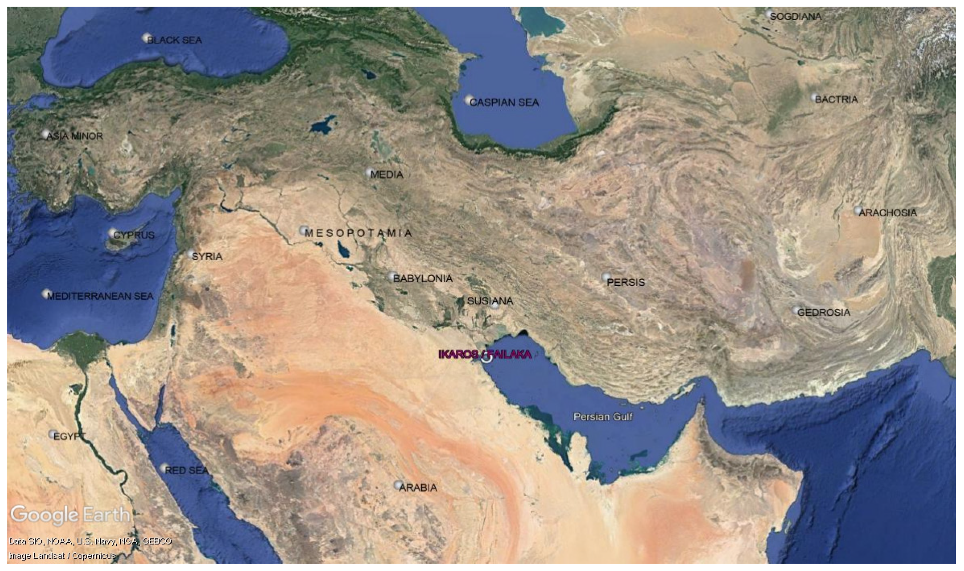
The island had a long cultic tradition that pre-dated the Hellenistic period. Ancient literary sources, such as Arrian, that refer to the island briefly mention its religious life. The majority of Greek inscriptions found on Ikaros/Failaka reveal which gods were worshipped on the island and various aspects of religious life. In this part of the paper, we will examine what happened when the Seleucids conquered the island and annexed it to their kingdom and how and to what extent the sacred landscape changed. We will employ archaeological evidence to deal with the sacred space of the island as an environment created by such architectural features as temples and sanctuaries in combination with human religious activities and practices. We have already mentioned that the population of the island varied over time and that, during the Seleucid occupation, there was a military garrison. We will not, however, discuss in detail the archaeological finds and the wider problems raised by some of them, as our aim is to put together the material evidence in such a way as to explain how diverse cultural elements influenced the sacred landscape of the island.
Three sacred places on Ikaros/Failaka give us information about religious life, the interaction of Greeks with the indigenous population and the connection of the island with other insular and mainland places. These are: the old sanctuary of Tell Khazneh pre-dating the Seleucid occupation of the island, the fortress and its temples erected by the first Seleucids6 and the new Hellenistic sanctuary in area B6 that was built later, in ca. 200 BC (Hannestad 2019, pp. 312–30). These sacred landscapes and material culture reveal the existence of a cultural dialogue between, on the one side, the indigenous peoples and their traditions and, on the other, Greco-Macedonian settlers, mercenaries, travellers or sailors visiting the island.

4.1. The Pre-Hellenistic Sanctuary at Tell-Khazneh and Its Continuity

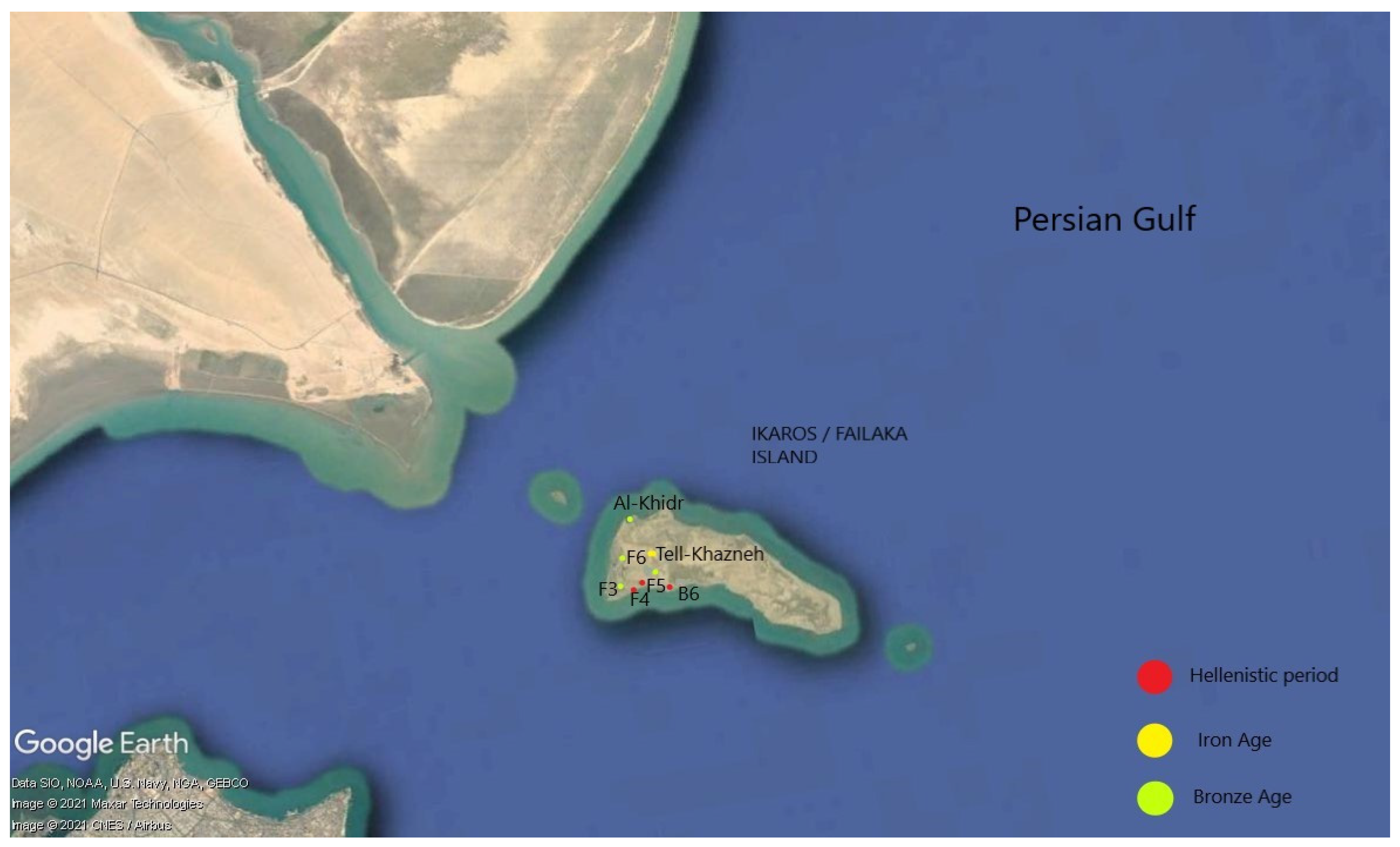
The oldest cultic centre predating the Seleucid occupation of Ikaros/Failaka is situated in the southwest of the island in the Tell Khazneh area. A few remains indicate that cultic use was made of this area from the pre-Hellenistic period to the mid-2nd century BC, when the area was abandoned (Hannestad 2019, pp. 315–16). Here artefacts were found, probably offerings that tied this spot to its Achaemenid religious past. Approximately 280 figurines were found in this sanctuary, among them many Persian figurines of horsemen, who are probably wearing the Persian Kyrbasia (Lesperance 2002, pp. 97–98). Male and female Mesopotamian figurines found at the sanctuary display similarities with terracotta offerings found in the cities of southern Mesopotamia, such as Uruk and Nippur. A Mesopotamian seal dating to the neo-Babylonian Empire depicts a priest of Nabu, the patron god of literacy and wisdom (Salles 1985, p. 588; 1986b, pp. 144–52).
As we have already noted, Arrian (Anabasis 7.20.3–4), when referring to the island, notes the existence of a shrine of Artemis and that the inhabitants spent their lives around it. There is no other literary information on the cultic rituals performed in this shrine or the identity of the inhabitants. Hannestad (2019, p. 316), on the basis of a coin hoard found at the area, suggests that ‘the sanctuary was visited in first quarter of the 3rd century by mercenaries and/or soldiers probably coming from Mesopotamia via Euphrates’. Perhaps the first visitors to the island, influenced by the thick forest and the wild animals found on the island, guessed that this shrine belonged to Artemis, the goddess of hunting, or perhaps they thought that it was a shrine to the goddess Anahita, an ancient Iranian goddess who in the Near East is frequently identified with Artemis (Hjerrild 2009, pp. 42–43) or of the Mesopotamian goddess Nananya, spouse of Nabu, who is frequently assimilated with Artemis (Lesperance 2002, pp. 111–12).
In this area a very mutilated inscription was found that refers to the sacrifice performed by a Greco-Macedonian “hegemon”, whose name ends with -telos (IK Estremo oriente 417: 4th/3rd century BC). There is no reference to the god to whom he sacrificed, but it may have been a female deity. Archaeological evidence derived from stratigraphical information reveals that at the third excavation level, dating to the Hellenistic period, Hellenistic-style female figurines were found, five of them being nude female figurines with their arms at their sides. Several incense altars were also found (Lesperance 2002, p. 98). On the basis of archaeological discoveries, Salles suggests that this sanctuary may have been that of Artemis referred to by Arrian (Anabasis 7.20.3–4) (Hannestad 2019, p. 326), although, the pre-Hellenistic terracotta offerings found here connect this sanctuary with a male divinity (Salles 1985, p. 590), probably with Nabu, the son of the Babylonian god Marduk (Gachet and Salles 1990, p. 210).
Two inscriptions dated to the 3rd century BC give us some idea why the Greco-Macedonians used this sanctuary. The inscriptions mention dedications that were made by Soteles (the Athenian or the son of Athenaios) (Roueché and Sherwin-White 1985, pp. 4–5). The first dedication was made by Soteles and the soldiers to Zeus Soter, Poseidon and Artemis Soteira and the second dedication was made by Soteles to Poseidon Asphaleios. Roueché and Sherwin-White (1985, p. 10) suggest that the dedications were made by the garrison of the early Seleucids established on the island. The fact that, during the early years after the Seleucids established their power on the island, there was no Greek temple, although there are inscriptional references to sacrifices taking place on the island, leads one to believe that the Greco-Macedonians probably sacrificed in local temples and sanctuaries, such as that of Tell Khazneh. Canepa (2018, p. 179) notes that ‘the archaeological material …suggests [that] the Greco-Macedonian settlers engaged pre-existing cult sites once the military installation was founded’.
The dedications of Soteles were made to Zeus, the supreme god of the Greek pantheon, to Poseidon, who granted safety to sailors and protected the ports, and to Artemis. Artemis was chosen, probably because of the connection between of Ikaros/Failaka with Ikaros in the Aegean.7 Artemis was patroness of Ikarian sailors of the Aegean and also protector of hunters and of wild animals. On the north-west coast of the Aegean island of Ikaros, there was a port that offered a safe anchorage in the midst of the dangerous seas around the island. On Ikaros, too, there also stood a temple dedicated to Artemis Tauropolos at Oenoe and a temple of Artemis at Nas. On the island of Ikaros/Failaka in the Persian Gulf, there was, as we have discussed earlier, a temenos that the Greco-Macedonian sailors identified as a shrine of the Greek goddess Artemis (Arrian Anabasis 7.20.7–8) or an oracle of Artemis Tauropolos (Strabo Geogr 16.3.2). In the first dedication made by Soteles, the goddess is referred to as Artemis Soteira (Saviour), who protected sailors and brought them safely to the island. The second dedication by Soteles was made in honour of Poseidon Asphaleios. According to Xenophon (Hell. 4.7.4.), paeans in honour of Poseidon Asphaleios were sung whenever an earthquake occurred, in order to appease the force behind it and to lessen its effect (Katsonopoulou 2021, p. 132). Although the worship of Poseidon Asphaleios was connected mainly with earthquakes and had spread to many places in the Mediterranean world, Katsonopoulou (2021, p. 132) notes that in the Hellenistic city of Dionysopolis on the Bulgarian Black Sea coast there was a cult of Poseidon Asphaleios connected with ‘the safety of their cities and ports’. In our case, the dedication of Soteles to Poseidon Asphaleios was probably made after the dedicator had arrived safely on Ikaros/Failaka. Soteles, who had probably faced the monsoons in the area, may then have made this dedication to thank Poseidon for his safe return.
Although no buildings survive from the Tell Khazneh sanctuary (Salles 1986a, pp. 107–9), the archaeological record in the area reveals the co-existence of pre-Hellenistic local artifacts, particularly figurines, with Greek artifacts, such as incense altars and pottery (Lesperance 2002, pp. 97–98). Although this temple was a sacred place for the old inhabitants of the island, this did not stop Greco-Macedonians from sacrificing here and using the temple to perform their rituals. Their actions are perhaps a manifestation of Seleucid religious policy that made use of pre-existing local religious infrastructures (Canepa 2018), so as to create a unified religious environment that allowed the monarchs to control remote strategic areas of their kingdom. Yet it may also be connected with the multi-ethnic composition of the Seleucid garrisons. Naveh (1995, pp. 2–3), in his study of the two Greek inscriptions regarding Soteles and of a contemporary Aramaic inscription found on the island, argues that the Seleucid military garrison included Iranian soldiers and officers. Non-Greek Seleucid soldiers, probably familiar both with local eastern religious practices and with Greek practices, must have facilitated the cultural dialogue between local and Greek cultic habits.

4.2. The Fortress

The cultural dialogue between Greek and local traditions is also evident in the fortress, whose architectural structure and temples combine local architectural forms and practices with Greek traditional architectural styles, thereby creating a hybrid cultural identity. The Hellenistic fortress stood on the south-west corner of the island. In the same area, on a site approximately 100 metres distant from the Hellenistic fortress, a temple- tower was built around 2000 BC, during the Dilmun period. The benefits of the site were already evident to the Bronze Age inhabitants of the island, who built a temple-tower there (Calvet et al. 2008, p. 22). Temple-towers in the East were erected at strategic spots and, being visible from a distance, were used by sailors for orientation and navigation (Calvet et al. 2008, p. 25). These temple-towers also served to observe the arrival of ships. In the temples included in these temple-towers, sailors offered thanks to the gods who had protected them and brought them safely home. Calvet (Calvet et al. 2008, p. 25) connects the existence of temple-towers with the presence of important sea and land routes in the East. He compares the temple-tower of Ugarit, an ancient port in northern Syria, with that of Ikaros/Failaka and concludes that, during the Bronze Age, these ‘temple towers are situated at points of intense trade, in places of transit between the sea routes and the land routes’. Calvet (Calvet et al. 2008, p. 23) argues that the thriving trade that existed in these areas facilitated the creation of religious, cultural and intellectual ties between local populations and their neighbours.
The Seleucids, playing their part in the long history of Ikaros/Failaka and realising its importance of the area, decided to erect their fortress at this point on the island (Gelin 2014, pp. 88–89). The strategic location of the hill and the existence of wells of fresh water, indispensable for the survival of any inhabitants, made this a highly desirable site for a fortress. The use of the old eastern model of the temple-tower in this Seleucid rebuilding reveals a continuation of an older tradition. Irrespective of the architectural form, the geographical position of the fortress, its religious role and its importance in navigation show that the building had multiple functions and strongly resembled the temple-towers of the Bronze Age. Archaeological finds and, in particular, the presence of fragments of Attic black glaze bowls indicate that the first phase of the enclosure was built around 300 BC, perhaps the work of Antiochos I (Gelin 2014, p. 88). It served primarily as accommodation for the Seleucid garrison and to protect Temples A and B that stood within its precincts.
Temple A was a typical Greek style temple with naos, pronaos, altar, stylobates, krepis and Greek-style ornamentation, such as acroteria (Jeppesen 1989, pp. 25–28; Gelin 2014, p. 89; Lesperance 2002, pp. 64, 67–68). The builders of the temple, however, combined these traditional Greek elements with Achaemenid-influenced column bases of local limestone (Jeppesen 1989, p. 34). Temple B stood a small distance from Temple A. It displays the same plan as Temple A and the same characteristics of a Greek temple in the form naos and pronaos, although Gelin (2014, p. 89) believes that its plan is oriental. Temple B displays less decoration than Temple A and has a circular altar (Lesperance 2002, pp. 68–73).
How did the indigenous population deal with these changes? Written sources concerning the local population are scanty. As we have said, Arrian notes that they lived around a sanctuary (Anabasis 7.20.3–4). A letter, inscribed on a stele, which mentions a now unknown Seleucid king (probably Seleukos II) and mentions arrangements concerning religious matters and other practical issues that arose on the island (IK Estremo oriente 422; l.15), divides the locals into neokoroi, who were local servants of the gods (or eminent members of the local society with cultic responsibilities), and into other inhabitants. Roueché and Sherwin-White (1985, p. 32) discuss the role of neokoroi ‘who, on the analogy of the famous sanctuaries of Artemis at Sardis and Ephesus, as well as that at Amyzon, were important administrators responsible for temple administration as well as for the organisation of the cults in their care’. The fact that the neokoroi hold their religious office after the island has been annexed by the Seleucids demonstrates that the Seleucids, far from wanting to break the link with the past, actively desired that old and new religious practices should co-exist. Moreover, the fact that local religious officials used a Greek term (neokoroi) to label them is an example of how Seleucid rule dealt with religious matters. Unfortunately, the lack of indigenous written sources means that we cannot construct a complete picture of the relations between local religious aristocracy and the Greco-Macedonian administration.
In the letter that we have just looked at, Ikadion, a Seleucid official, conveys the will of the Seleucid king to his subordinate, Anaxarchos, that limits be put on the treatment of locals by Greco-Macedonian colonists and that certain religious, economic and property matters be settled. He orders this letter to be inscribed on a stele in front of Temple A in the sacred fortress. These measures may have been triggered by disturbances and clashes between the indigenous population and colonists, since the king was clearly anxious that his ruling should be displayed in a prominent public space. The king mentions, among others matters, the relocation of a temple left unfinished by his ancestors, such an operation never having been carried out before (Estremo oriente 422; ll. 4–8). Perhaps this projected relocation was one reason for any clashes that may lie behind the ruling published on the stele. The king apparently requested that the hieron of Soteira, probably the shrine of Artemis Soteira, be relocated to the interior of the fortress (Estremo oriente 422; ll. 5–6). It is not clear from the letter where this altar of Soteira was situated. Roueché and Sherwin-White (1985, p. 32) argue that this old temple was either the temple of Artemis that the explorers of Alexander discovered on the island or the Achaemenid shrine of Tell Khazneh or perhaps some other shrine elsewhere. The main reason for the royal decision was to protect the new sanctuary and to provide ‘room for the community to dwell around it’ (Roueché and Sherwin-White 1985, p. 32). Hannestad and Potts (1990, p. 123) argue that the evidence of Ikaros/Failaka reveals how ‘a local pre-Seleucid cult was transformed on royal command into something at least reminiscent of Greek cultic practice’.
Temple A of the fortress existed before the hieron was moved inside the fortress, which perhaps indicates that more than one god was worshipped in the temple. That this was so is suggested by the second inscription found in Temple A, which mentions the gods to which the inhabitants of Ikaros/Failaka dedicated the altar. Notably, the inscriptions do not distinguish between the local population and Greco-Macedonians (ΙΚ Estremo oriente 420). All this written evidence leads one to suspect that the local inhabitants had no separate administrative organisation. Their officials were mainly concerned with the local cult and the administration of the temples. By contrast, the Greco-Macedonians lived in a semi-urbanised community (Petropoulou 2006, p. 147), which was not a polis and was subject to the orders of the representatives of the Seleucids. The establishment of athletic and music competitions (IK Estremo oriente 422: ll. 11–12) as part of the religious festival that took place on the occasion of the relocation of the altar reveals that, even in areas on the very edge of their kingdom, the Seleucids promoted and supported Greek cultural practices.
Let us consider another factor connected with the relocation of the altar and the co-existence of Greco-Macedonians and the indigenous population alongside each other that is revealed through archaeological finds from the island. The relocation of the cult of Artemis Soteira, the divine protector of sailors, to the Hellenistic fortress, the protection of her sanctuary, and the offerings made by her pilgrims are clearly connected with the protection and use of the temple-towers for religious purposes during the Bronze Age. In the Hellenistic period, towers were erected on islets in the Aegean to protect sea routes from pirates or other hostile individuals, to ensure the maintenance of the ‘complex matrix of intercommunication in the seascape of the Aegean’ (Constantakopoulou 2007, p. 198) and to indicate that more powerful neighbours dominated and exploited the natural resources of these islets (Constantakopoulou 2007, p. 198). The towers of the Hellenistic period probably also served as a means of protection and as markers of dominion and territory. Perhaps, then, when the Hellenistic-style tower spread through the east, it was combined with the eastern temple-tower tradition and so acquired yet another function, that of a shrine. Such temple-towers are found from the Mediterranean coast, ‘as at Alalakh, ancient Atchana, and Ras Shamra, ancient Ugarit, to the shores of the Gulf, as at Failaka, and in Mesopotamia, as at Mari and other Mesopotamian sites’ (Calvet et al. 2008, p. 24). This type of temple-tower had evolved from the ziggurats (Calvet et al. 2008, p. 24) built by indigenous populations, such as Sumerians, Babylonians, Akkadians, and Elamites, to worship local gods (Walton 1995, p. 158). This concept of the temple–tower, rooted in local tradition, probably influenced Seleucid architects when they came to construct their fortress.
As the archaeological discoveries now stand, there is evidence of Hellenistic fortifications with sanctuaries in Seleucid territory (Canepa 2018), but the size, structure and style of the Ikaros/Failaka enclosure seems to be unique. Thus, it would seem that, although this enclosure and its temples were modelled after local eastern and Greek prototypes, it kept its unique character and reflects Seleucid policy in the area. In the case of Ikaros/Failaka, in addition to the Greco-Macedonians, indigenous religious officials (Estremo oriente 422, l.15) also took part in the rituals practiced in the fortress. Even archaeological finds from the period, when Seleucid power had declined in the area and the Seleucid garrison abandoned the fortress, show that the local inhabitants used the temples uninterruptedly (Gelin 2014, p. 89), which indicates that they had embraced the mixture of local and Greco-Macedonian religious traditions and continued to perform their own rituals. Such behaviour clearly demonstrates that the Seleucids, instead of aiming to impose any one religious tradition upon another, created new, heterogeneous religious forms accepted and promoted by the local population and Greco-Macedonians. Such religious co-existence probably also mirrored the relations between the local population and the Macedonian garrison.
After the period of Arab occupation of the island (246–223 BC), Antiochos III restored Seleucid power over the area. He reinforced and extended the fortress and awarded it the status of a colony (Gelin 2014, p. 89). This event is reflected in the increasing number of houses erected within and outside the fortress. The presence of an indigenous population or at least of non-Greek settlers in the fortress, is revealed by finds there consisting of terracotta figurines and ceramics, most of which display traditional Mesopotamian stylistic traits. These finds included nude female figures inspired by Babylonian and Parthian figures, terracotta horsemen whose figures display similarities with those found at Uruk and Babylon and in southern Iran and, ceramic vessels Mesopotamian and Arab in style (Lesperance 2002, pp. 78–83). The archaeological finds from the fortress also included model boats, which reveal the maritime occupations of the owners or dedicators. Although most of them display similarities to model boats from Babylon and Seleukeia-on-the-Tigris (Chavane 1990, p. 286), in the view of Mathiesen (1982) some fragments display parallels with objects found elsewhere in the Mediterranean, such as at Salamis on Cyprus (Chavane 1990, p. 286). These boats are either to be connected with the occupations of the inhabitants or were used domestically as ornaments or toys. They may also have had some religious purpose, a feature attested elsewhere in the Eastern Mediterranean and Near East (Chavane 1990, pp. 286–89). These model boats may have been offerings made to the gods before a voyage or after a safe return to the island, or they may have been dedications made by fishermen after a plentiful catch. Prayers offered at sanctuaries and temples, sacrifices, and offerings to the god-protectors of sailors were common public and private cultic practices, designed to secure the benevolence of the gods towards navigators (Van Straten 1981, p. 65).
The offerings made at temples demonstrate both the piety of the donor and his hopes for protection during future maritime endeavours (Van Straten 1981, pp. 72–73). The material from which these offerings were made and the stylistic influences they display clearly express a desire on the part of the donor to display his wealth before the public, his stylistic preferences and his connections with either the Achaemenid and Babylonian past or with Greco-Macedonian tradition. Monloup (1984, p. 148) connects these boats with burial traditions and suggests that they symbolised the voyage of the dead on Charon’s skiff. This ancient Greek tradition and, in particular, the appearance of such vessels in tombs, is attested on Crete and Cyprus (Chavane 1990, p. 286). In addition to the model boats, dedications of naval equipment were found at the sanctuaries in the fortress. These include two small stone anchors offered at the sanctuaries (Chavane 1990, p. 289) that resemble anchors found in Salamis on Cyprus (Chavane 1975, p. 115, no. 356–57) which imitate Near Eastern prototypes from the Bronze Age. It is easy to see why an anchor, vital for maritime travel, especially among the windy islands of the Persian Gulf, should have been offered. Indeed, an anchor was something sacred in that it kept a ship stable in bad weather and the safety of the ship and the crew directly depended on it (Kapitän 1985, p. 152). Many items connected with fishing, such as fishing weights, flat and lenticular spindles and spindle-shaped spherical caps, were found in the fortress and in the Hellenistic sanctuary in area B6. Fishing was an important economic activity for the inhabitants of the island and was indispensable for their subsistence. Multiple offerings demonstrate people’s piety towards the divine protectors of sailors and fishermen.
The way in which the artifacts found in the fortress were manufactured (Gachet 1990) or the way in which they represented humans, animals or deities expresses the cultural identity of the owner, their stylistic preferences and their social status. Because the island was connected with so many other places, these artifacts are naturally the creation of various artistic trends that combined eastern and Greco-Macedonian stylistic forms (Connelly 1990). A stone statuette of a bottlenose dolphin created in a local workshop and dating to the mid-2nd century BC was found in the fortress and throws light on the local sculptural aesthetic and the view of the inhabitants of dolphins. The bottlenose dolphin lives in shoal-waters, near shores and bays (Lilly 1962) and statuettes and other images of dolphins were widespread round the Mediterranean. The Phoenician dolphin cult led to the incorporation of the dolphin into Greek religious life. Dolphins were considered to be protectors of fisherman and sailors and were connected chiefly with the worship of Poseidon and Apollo (Csapo 2003, p. 94). Among the archaeological finds from Ikaros/Failaka connected with the religious or cultural life of the inhabitants, there is a statuette of Papposilenos, the style of which displays similarities with figurines from Pergamon and Kharayeb in the Lebanon (Connelly 1990, p. 214). The Ikaros/Failaka Silenus was connected with the Dionysiac cult of the Greco-Macedonians (Arrian, Anabasis 4.8.1) or ‘possibly [reflects] the influence of theater in the daily lives of soldiers posted on the Eastern frontier’ (Connelly 1990, p. 214). In the fortress, a fragmentary Greek-style statuette of a young Herakles was also found (Connelly 1990, p. 210). Terracotta figurines of Herakles were also found in the fortress, but their style displays Near Eastern influences, especially from Mesopotamia and Susiana (Connelly 1990, p. 210). The worship of Herakles was widespread in the East. Statuettes of Herakles have been discovered at Nippur, Uruk, Hatra, Dura-Europus, Assur and Begram (Connelly 1990, p. 211). These figurines may depict Herakles in his role of protector of those who, like him, make long-distance expeditions (Diodorus 4.18.4–5). Herakles reached the furthest limits of seafaring in the West and confronted the sea in all its moods and other dangers, too (Pindar Nemean 3), but nevertheless accomplished his goal and returned home. The Greco-Macedonians probably saw similarities with Herakles’ journey in their own experiences and no doubt hoped that, if they worshipped him, he would grant them the safe return home that he himself enjoyed.
Architectural forms or domestic and cultic objects show that Seleucid policy was to establish their cultural influence on the foundation offered by local Neo-Babylonian and Achaemenid cultural tradition. Local cultural elements combined with Greco-Macedonian practices, influencing each other to create a unified new cultural form within the Seleucid kingdom. By reshaping the older local sacred landscapes, the Seleucids created a heterogeneous cultural environment. This allowed the indigenous population to continue their local practices and traditions, even when Seleucid presence on the island had faded (Gelin 2014), and to live in an environment that displayed cultural elements from their past, but at the same time to adopt some Greco-Macedonian cultural elements without losing their local identity.

4.3. The New Hellenistic Sanctuary in Area B6

The remains of the Hellenistic sanctuary, built in ca. 200 BC and lying along the beach of the southwest coast of the island, reveal the existence of a Greek-style temple, complete with naos, pronaos, a colonnaded porch and altar. Lesperance (2002, pp. 90–93) believes the sanctuary was built in two phases. The colonnade of the sanctuary of the first phase displays similarities to the heroon of Kinneas at Aï Khanoum dated to the early 3rd century BC. The modifications that took place during the second phase (early 2nd to mid-2nd century BC) are comparable to features of the temple of Herakles at Masjed Soleiman in Susiana (Salles 1985, p. 584). The shrine also shows many similarities with the shrines of Hatra (Parthian city), which display Assyrian and Mesopotamian forms (Downey 1987, p. 43; Lesperance 2002, pp. 92–93). All this clearly demonstrates how heterogeneous Seleucid religious architectural forms were, and such heterogeneity illustrates the diversity of cultural influences that existed in the Near East in the 2nd century BC. The Seleucid Hellenistic sanctuary of Ikaros/Failaka, which was the last building on the island that the Seleucids erected, probably during the reign of Antiochos III (Salles 1985, p. 586), was built in a period of prosperity during Seleucid rule over the island. The Arab occupation (246–223 BC) of the island was now over. Ceramic vessels found in the sanctuary reveal trade connections of the island with Mesopotamia, Susiana and the Eastern Arabian Peninsula (Lesperance 2002, pp. 94–96). The architectural form of the sanctuary displays an attachment to local forms. Many cult objects were found at the sanctuary, such as terracotta figurines, small stone altars, heads probably of Herakles and Artemis (or the oriental Atargatis), model boats, nude female figurines and offerings consisting of metal objects (Salles 1985, pp. 584–86). Although Greek and Near Eastern cultural influences are revealed in the archaeological finds from the sanctuary, it is difficult to reconstruct the social status of the dedicators. The cultural diversity evident in the architectural form of the sanctuary is also reflected in archaeological finds. Thus, it seems that the sanctuary was used by Greco-Macedonian soldiers, Hellenised non-Greek colonists, members of the indigenous population and foreigners who had come the island.

5. Conclusions

To conclude this paper, I would like to underline certain key points that have arisen in this study.
Archaeological finds make it very clear that Ikaros/Failaka was far from being an isolated spot. Indeed, the connection and connectivity of the island to many mainland places made it part of a chain of areas of military/political, economic and religious interest to the Seleucids. Archaeological finds also make it clear that the notion of insularity can be applied to the island, albeit with some restrictions caused by the fluctuation in human settlement. The inhabitants constructed their cultural identity in distinct ways, based partly on their cultural past and on their own rules and customs dictating their contacts with other cultures and partly under the influence of Seleucid rule. We have observed that the sacred landscapes of Ikaros/Failaka were shaped in accord with Seleucid cultural and political agendas. The kings intervened to settle religious disputes and other matters and to promote a mixing of heterogeneous cultural elements, in an effort to create new religious forms acceptable to both the Greco-Macedonians and the indigenous population.
We have also observed that the respect towards the local inhabitants promoted and imposed on Greco-Macedonian colonists by the Seleucid kings facilitated the co-habitation of the Greco-Macedonians alongside the local population and promoted the creation of a cultural identity that connected aspects of Greek culture with Near Eastern cultural forms. This cultural dialogue is reflected in archaeological finds, which include religious architectural forms of the temples, votive offerings consisting of statuettes and terracotta figurines, items for domestic and everyday life and figurines for household or public worship. Stratigraphic data (Hassan et al. 2020) shows that the indigenous population continued to use the sacred locations within the fortress, even in periods when the Seleucid military garrison had abandoned the island (Gelin 2014, p. 89). After the re-occupation of the island by the Seleucids and especially during the peaceful period from 223 to 163 BC, the kings promoted the connections of the island with the outside world. This is clear from religious architecture, the offerings made in the sanctuaries and coins (Amandry and Callot 1988).
Although Ikaros/Failaka is a small island, during the Hellenistic period, the intra-insular connections were created after the arrival of the Seleucids, while extra-insular ties came into being and changed over time. This made for the absorption of this island, on the edge of the Seleucid kingdom, into the political and cultural/religious whole promoted by the Seleucids and for the shaping of the religious landscape of the island in accordance with Seleucid policy and local eastern tradition.

Funding

This research received no external funding.

Institutional Review Board Statement

Not applicable.

Informed Consent Statement

Not applicable.

Data Availability Statement

Not applicable.

Acknowledgments

I would like to thank the editors and the reviewers for their careful reading of my manuscript, valuable comments, constructive suggestions and corrections.

Conflicts of Interest

The author declares no conflict of interest.

Notes

1
Arab and Indian sailors, long aware of the monsoons, exploited them to cross the Indian Ocean. Hippalos (1st century BC) was the first Greek sailor and merchant, according to Periplus Maris Erythraei (ch. 57) and Pliny (Natural History vi 100, 104, 106), to discover the direct trade route from the Red Sea to India via the Indian Ocean and to handle the monsoon winds safely (Hatcher 2013, pp. 19–29). Yet the Greeks did not find the journey easy, as Strabo reveals (Geog. 2.5.12).
2
Drawing on an important Greek inscription found on Bahrain (IK Estremo oriente 147/427: 140–124 BC), Kosmin (2013, p. 76) notes that ‘the religious geography of the Hellenistic Gulf seems mapped onto a network of communication and control. The naos of Dioskouroi on Bahrain, the various temples on Failaka, the double-trophy at Ras Musandam and the sacred mountain on Kharg sacralize the nesiotic space’. Perhaps we have here a network of shrines and temples created by and for the needs of sailors in the Gulf. Kosmin (2013, p. 76, n. 146) compares this religious network with ‘the marine sanctuaries and sailors’ dedications of the islands of Kasos, Saros, Kalche and Telos’ in the Aegean.
3
Constantakopoulou provides an analogous example from the Aegean (Constantakopoulou 2007, p. 87). She notes that the Aegean islands ‘provided a wealth of inlets and bays, where a ship, and more particularly an oared warship, could shelter during storms or be beached during an overnight stay…any power wishing to maintain control over Aegean Sea had to control its islands as well’.
4
If a small island was fortified, it was probably intended to be a secure military base ‘because of the security and isolation’ that it provides for military operations (Constantakopoulou 2007, p. 120).
5
The presence of fresh-water wells, so vital for the inhabitants, in this part of the island naturally necessitated the building of the fort here to protect this resource.
6
According to Salles (1985, p. 580) the ceramic evidence found in the area places the erection of the fortress in the first half of the 3rd century BC. Jeppesen (1989, pp. 73–76) believes that the two temples may have been built later, Temple A dating roughly to 260 BC and Temple B to about 240 BC.
7
The island of Ikaros/Failaka in the Persian Gulf was named after the Aegean island Ikaros in the Aegean.

References

  1. Amandry, Michel, and Olivier Callot. 1988. Le trésor de Failaka 1984 (Koweit). Revue Numismatique 6: 64–77. [Google Scholar] [CrossRef]
  2. Braudel, Fernand. 1972. The Mediterranean and the Mediterranean World in the Age of Philip II. Berkeley, Los Angeles and London: University of California Press. [Google Scholar]
  3. Broodbank, Cyprian. 2000. An Island Archaeology of the Early Cyclades. Cambridge: Cambridge University Press. [Google Scholar]
  4. Brughmans, Tom. 2013. Thinking through Networks: A Review of Formal Network Methods in Archaeology. Journal of Archaeological Method and Theory 20: 623–62. [Google Scholar] [CrossRef]
  5. Calvet, Yves, Marielle Pic, and Elizabeth Willcox. 2008. The Temple-Tower of Failaka in its Near Eastern Context. MOM Éditions 48: 21–25. [Google Scholar]
  6. Canepa, Matthew P. 2018. The Iranian Expanse: Transforming Royal Identity through Architecture, Landscape, and the Built Environment, 550 BCE–642 CE. Berkeley: University of California Press. [Google Scholar] [CrossRef]
  7. Chavane, Marie-José. 1975. Les petits objets. In Salamine de Cypre VI. Paris: De Boccard. [Google Scholar]
  8. Chavane, Marie-José. 1990. Les petits objets de la forteresse. MOM Éditions 18: 285–302. Available online: https://www.persee.fr/doc/mom_0766-0510_1990_rpm_18_1_1768 (accessed on 31 January 2021).
  9. Cohen, Getzel M. 2013. The Hellenistic Settlements in the East from Armenia and Mesopotamia to Bactria and India. Berkeley: University of California Press. [Google Scholar]
  10. Connelly, Joan Breton. 1990. The Terracotta Figurines. Greek Types and Cult. MOM Éditions 18: 209–20. [Google Scholar]
  11. Constantakopoulou, Christy. 2007. The Dance of the Islands: Insularity, Networks, the Athenian Empire, and the Aegean World. Oxford: Oxford University Press. [Google Scholar]
  12. Csapo, Eric. 2003. The Dolphins of Dionysus. In Poetry, Theory, Praxis: The Social Life of Myth, World and Image in Ancient Greece. Essays in Honour of William J. Slater. Edited by Eric Csapo and Margaret C. Miller. Oxford: Oxbow Books, pp. 69–98. [Google Scholar]
  13. Downey, Susan. 1987. Regional Variations in Parthian Religious Architecture. Mesopotamia 22: 29–55. [Google Scholar]
  14. Freyberger, Klaus. 2016. The Function and Significance of Fortified Sanctuary Precincts in the Eastern Mediterranean World During the Hellenistic and Roman Periods. In Focus on Fortifications: New Research on Fortifications in the Ancient Mediterranean and the Near East. Edited by Rune Frederiksen, Silke Müth, Peter I. Schneider and Mike Schnelle. Oxford: Oxbow Books, pp. 244–62. [Google Scholar] [CrossRef]
  15. Gachet, Jacqueline, and Jean-François Salles. 1990. Iconographie et cultes à Failaka, Koweit. Mesopotamia 25: 193–215. [Google Scholar]
  16. Gachet, Jacqueline. 1990. Un habitat du IIe siècle av. J.-Ch. dans la forteresse de Failaka. MOM Éditions 18: 167–91. [Google Scholar]
  17. Gelin, Mathilde. 2014. New French-Kuwaiti Research in the Hellenistic Fortress of Failaka-Ikaros. In Proceedings of the 8th International Congress on the Archaeology of the Ancient Near East. Edited by Piotr Bielinski, Michal Gawlikowski, Rafal Kolinski, Dorota Lawecka, Arkadiusz Soltysiak and Zuzanna Wygnanska. Excavation and Progress Reports. Wiesbanden: Harrassowitz Verlag, pp. 87–100. [Google Scholar]
  18. Hannestad, Lise, and Daniel T. Potts. 1990. Temple Architecture in the Seleucid Kingdom. In Religion and Religious Practice in the Seleucid Kingdom. Edited by Per Bilde, Troels Engberg-Pedersen, Lise Hannestad and Jan Zahle. Aarhus: Aarhus University Press, pp. 91–124. [Google Scholar]
  19. Hannestad, Lise. 2019. On the Periphery of the Seleucid Kingdom: Failaka Revisited. In New Perspectives in Seleucid History, Archaeology and Numismatics: Studies in Honor of Getzel M. Cohen. Edited by Roland Oetjen. Berlin: De Gruyter, pp. 312–32. [Google Scholar]
  20. Hassan, Ahmed, Muhammad G. Almatar, Magdy Torab, and Casey D. Allen. 2020. Environmental Urban Plan for Failaka Island, Kuwait: A Study in Urban Geomorphology. Sustainability 12: 7125. [Google Scholar] [CrossRef]
  21. Hatcher, Scott. 2013. The Birth of the Monsoon Winds: On the Existence and Understanding of Hippalus, and the ‘Discovery’of the Apogeous Trade Winds. Terrae Incognitae 45: 19–29. [Google Scholar] [CrossRef]
  22. Hjerrild, Bodil. 2009. Near Eastern Equivalents to Artemis. In From Artemis to Diana: The Goddess of Man and Beast. Edited by Tobias Fischer-Hansen and Birte Poulsen. Copenhagen: Museum Tusculanum Press, vol. 12, pp. 41–50. [Google Scholar]
  23. Horden, Peregrine, and Nicholas Purcell. 2000. The Corrupting Sea. A Study of Mediterranean History. Oxford: Blackwell. [Google Scholar]
  24. Jeppesen, Kristian. 1989. Ikaros: The Hellenistic Settlements. Vol. 3. The Sacred Enclosure in the Early Hellenistic Period: With an Appendix on Epigraphical Finds. Aarhus: Moesgård, Danish Archaeological Investigations on Failaka, Kuwait, Jutland Archaeological Society Publication, Nr. XVI. vol. 3. [Google Scholar]
  25. Kapitän, Gerhard. 1985. Archaeological Evidence for Rituals and Customs on Ancient Ships. In Tropis I. 1st International Symposium on Ship Construction in Antiquity Proceedings. Piraeus: Hellenic Institute for the Preservation of Nautical Tradition, pp. 147–62. [Google Scholar]
  26. Katsonopoulou, Dora. 2021. The Cult of Poseidon Helikonios. História: Questões & Debates 69: 121–35. [Google Scholar]
  27. Knapp, A. Bernard. 2008. Prehistoric and Protohistoric Cyprus: Identity, Insularity, and Connectivity. Oxford: Oxford University Press. [Google Scholar]
  28. Kosmin, Paul. 2013. Rethinking the Hellenistic Gulf: The New Greek Inscription from Bahrain. The Journal of Hellenic Studies 133: 61–79. [Google Scholar] [CrossRef] [Green Version]
  29. Lesperance, Paul. 2002. Hellenistic Period Temples in the Middle East: Case Studies of Cross-Cultural Influences Upon Religious Structures. Master’s thesis, McMaster University, Hamilton, ON, Canada. Available online: http://hdl.handle.net/11375/12236 (accessed on 31 January 2021).
  30. Lilly, John C. 1962. Vocal Behavior of the Bottlenose Dolphin. Proceedings of the American Philosophical Society 106: 520–29. [Google Scholar]
  31. Mathiesen, Hans Erik. 1982. Ikaros, The Hellenistic Settlements. Danish Archaeological Investigations on Failaka, Kuwait, Vol. 1 The Terracotta Figurines. Copenhagen: Gyldendalske Boghandel (for Jutland Archaeological Society). [Google Scholar]
  32. Monloup, Thérèse. 1984. Les figurines de terre cuite de tradition archaïque. In Salamine de Chypre, 12. Paris: De Boccard. [Google Scholar]
  33. Naveh, Joseph. 1995. The Inscriptions from Failaka and the Lapidary Aramaic Script. Bulletin of the American Schools of Oriental Research 297: 1–4. [Google Scholar] [CrossRef]
  34. Petropoulou, Maria-Zoe. 2006. A Seleucid Settlement on Failaka. Epigraphica Anatolica 39: 139–47. [Google Scholar]
  35. Potts, Daniel T. 2009. The Archaeology and Early History of the Persian Gulf. In The Persian Gulf in History. Edited by Lawrence Potter. New York: Palgrave Macmillan, pp. 27–56. [Google Scholar]
  36. Potts, Daniel T. 2016. Cultural, Economic and Political Relations between Mesopotamia, the Gulf Region and India before Alexander. In Megasthenes Und Seine Zeit. Edited by Josef Wiesehöfer, Horst Brinkhaus and Reinhold Bichler. Classica et Orientalia Band 13. Wiesbanden: Harrassowitz Verlag, pp. 109–18. [Google Scholar]
  37. Roueché, Charlotte, and Susan Sherwin-White. 1985. Some Aspects of the Seleucid Empire: The Greek Inscriptions from Failaka, in the Arabian Gulf. Chiron 15: 1–39. [Google Scholar]
  38. Salles, Jean-François. 1985. Failaka, une île des dieux au large de Koweit. Comptes Rendus des Séances de l’Académie des Inscriptions et Belles-Lettres 129: 572–93. Available online: https://www.persee.fr/doc/crai_0065-0536_1985_num_129_4_14305 (accessed on 31 January 2021). [CrossRef]
  39. Salles, Jean-François. 1986a. Les fouilles de Tell Khazneh. MOM Éditions 12: 107–42. [Google Scholar]
  40. Salles, Jean-François. 1986b. Tell Khazneh: Les figurines en terre cuite. MOM Éditions 12: 143–200. [Google Scholar]
  41. Seland, Eivind Heldaas. 2013. Networks and Social Cohesion in Ancient Indian Ocean Trade: Geography, Ethnicity, Religion. Journal of Global History 8: 373–90. [Google Scholar] [CrossRef] [Green Version]
  42. Van Straten, Folkert T. 1981. Gifts for the Gods. In Faith, Hope and Worship. Aspects of Religious Mentality in the Ancient World. Edited by Hendrik Simon Versnel. Leiden: Brill, pp. 65–151. [Google Scholar]
  43. Walton, John H. 1995. The Mesopotamian Background of the Tower of Babel Account and Its Implications. Bulletin for Biblical Research 5: 155–75. [Google Scholar]
Figure 1. Map of the Persian Gulf showing the position of Ikaros/Failaka. The map was created by the author using Google Earth Pro maps.
Religions 12 01002 g001
Figure 2. Map of Ikaros/Failaka. The map was created by the author using Google Earth Pro maps.
Religions 12 01002 g002
Figure 3. Map of the Middle East showing the position of Ikaros/Failaka. The map was created by the author using Google Earth Pro maps.
Religions 12 01002 g003
Publisher’s Note: MDPI stays neutral with regard to jurisdictional claims in published maps and institutional affiliations.

