Abstract
Cyprus acquired special importance, especially from the thirteenth century onwards, on the Eastern Mediterranean’s pilgrimage network. Described by contemporary pilgrims as “Terra christianorum ultima”, the island was considered to be the last Christian land in the south-eastern Mediterranean on the pilgrims’ itinerary on their journey to the Holy Land. This study is concentrated on two maps of Cyprus dated to the fourteenth century and preserved in Milan: Biblioteca Ambrosiana, A95 sup. and Venice: Biblioteca Nazionale Marciana, gr. XI.21. It aims to explore the physical and spiritual mobility and interconnectivity in Cyprus during the late Middle Ages and to consider how these contribute to the development of pilgrimage sites directly related with maritime routes, seamen and travellers. These unique nautical maps captured the sea voyage which had Cyprus as a stopover, bringing to light new insights into fourteenth century Cyprus. The maritime shrines discussed in this article, which are usually “mixed” sacred sites, are directly related with sailors’ needs. They integrate into a wide network of communication, removing them partially from their local dimension.
1. Introduction
Cyprus, as the third largest island in the Mediterranean, represents an ideal study domain with clearly defined geographical boundaries, where blended cultures and different religious groups have been presented diachronically, from the prehistoric years to the most recent past. Thus, being defined and at the same time confined by the sea, communities on the island tended to interact with one another and with the outside world (cf. Hadjikyriakou 2017).
The intense commercial activity observed on the island and the economic prosperity to which it led, together with its strategic position close to Asia Minor, the Syropalestinian and the Egyptian coasts, rendered Cyprus the battleground between Byzantines, Arabs, Crusaders, Venetians, and Ottomans on several occasions. Cyprus, being the easternmost Christian land of the Mediterranean in the late Middle Ages, constituted a border between West and East. Therefore, the geographical position of the island at the crossroads of three continents (Europe, Asia, Africa) and par consequence, a passage for traders, pilgrims, and conquerors, diachronically played a role in the formation of its history.
This article aims to re-examine two maps of Cyprus dating to the fourteenth century, preserved in two manuscripts that contain medical treatises, i.e., Milan: Biblioteca Ambrosiana, A95 sup.; Venice: Biblioteca Nazionale Marciana, gr. XI.21. By reinterpreting these maps as reflections of a navigational map rather than as personal creations, we will draw upon a range of disciplinary approaches to show how Cyprus’ extensive maritime interconnectivity interacted with and contributed to the development of pilgrimages to the island during the late Middle Ages.
2. Cyprus as a Pilgrimage Centre during the Late Middle Ages
In general, the launch of Christian pilgrimage can be placed at the beginning of the fourth century (Maraval 1985). After the well-known religious journey of St. Helen (326 A.D.), mother of Constantine the Great, to Jerusalem, a myriad of Christian pilgrims from all over “New Rome” set out to walk in her footsteps. The pilgrimage to the sites of the Christ’s birth, life and passion was motivated by sincere spiritual longing and led to the hope of attaining salvation in the afterlife. Although the conquest of the Holy Land by the Arabs in the seventh century made pilgrimage to the loca sancta of Palestine and Egypt a much more difficult and dangerous proposition, Christians continued to make the journey from Western Europe and the lands of the Byzantine empire.
Cyprus has a long tradition of creating sacred spaces, from the late Bronze Age (ca. 1700–1125/1100 B.C.) until today (Papantoniou 2012; Papantoniou 2016). Indeed, the island was also one of the first lands outside the Holy Land and Palestine to adopt Christianity, long before it was attested in Athens, Rome, or Alexandria. The new religion spread throughout the island during the first mission of the apostles Paul, Barnabas, and Mark—the latter of Cypriot descent—in 45 A.D. (Acts of the Apostles 13: 4–12). Despite the early Christianisation of the island’s population, it was only in the fourth century that Cyprus acquired the institutional apparatus of Christianity, with several prominent bishops (cf. Deligiannakis 2018a, 2018b). Over the centuries, Christianity was strongly consolidated in the island. The well organised, autocephalous, local Church and its geographical position in the eastern corner of the Mediterranean and close to the Holy Land, constituted two of the main reasons for the development of a large number of pilgrimage sites on the island, which were shared by the Christian population. The fame of its saints and holy places has attracted over the centuries—and in some cases still attracts—many pilgrims via the maritime route. It is worth mentioning that one of the first pilgrims who visited the island to venerate its monasteries and shrines was St. Paul of Rome (347–404 A.D.), student of St. Jerome, who visited Cyprus in 385 A.D. and stayed there for ten days (Maraval 1996, p. 147).
Nevertheless, pilgrimage to the Holy Land seemed to flourish at the beginning of the second millennium, following heightened religious fervour (Jacoby 2016). A severe blow to overland pilgrimage occurred in 1071 with the Seljuk victory over the Byzantines at the Battle of Manzikert and the subsequent occupation of much of Asia Minor by the Seljuks. The Seljuk conquest of that part of Anatolia, through which ran the pilgrims’ road, was certainly a catalyst for the First Crusade (1096–99) which intended to make pilgrimage safer by asserting Christian control over the loca sancta and the main routes to and within the Holy Land. Indeed, the number of pilgrims increased after 1099 and a crowd of people, from all social and economic layers, undertook the journey to the Holy Land by taking either the terrestrial or the maritime route. This journey had a direct impact in Cyprus, as pilgrims stopped in Cyprus en route to Jerusalem for supplies. During this period, Cyprus had developed and promoted its own shrines in order to benefit from the crowds of travellers–pilgrims stopping over on the island. Therefore, the island became part of the whole journey. Not surprisingly, the majority of pilgrimage sites and monuments in Cyprus belonged to the Greek community. Pilgrimage sites and other sacred places in Cyprus consisted of shrines with healing relics, sacred springs, miraculous icons, and objects, as well as places such as caves, in which holy men lived (cf. Simsky 2020). Undoubtedly, pilgrimage sites were places of high religious, political, and economic importance in the Middle Ages (cf. Vionis and Papantoniou 2019, pp. 10–13). In several cases, they still maintain their importance today.
Cyprus acquired special importance, especially from the thirteenth century onwards, due to the conquest of Syria and Palestine by the Mamluks. As mentioned earlier, the island was the last Christian land in the south-eastern Mediterranean for pilgrims’ itinerary to the Holy Land. The German priest Ludolf of Sundheim, who visited Cyprus between 1336–41 during his journey to the Holy Land, had rightly described Cyprus as “Terra christianorum ultima” (Deycks 1851, p. 34; Burkiewicz 2018, p. 209). Moreover, it was an ideal base for controlling the Muslim Middle East and the transit trade between Europe, Asia, and North Africa (Balard 1993, pp. 271–82, esp. 276).
During the late Middle Ages, the journey to Jerusalem became more intense and more organised and Venice and Cyprus had a remarkable position within it (cf. Vingopoulou 2003). Venice was deeply involved in and monopolised the pilgrim traffic; it was the port of embarkation for pilgrimage to the Holy Land from Northern Italy and from countries beyond the Alps (Jacoby 2016, pp. 89–97). This sea journey from Venice to Jaffa was expensive, difficult, and dangerous and many of the travellers died during the trip. The travellers, before the departure, signed a contract with all the terms and conditions of the journey (duration, stopovers, food supplying etc.). The duration of the journey from the West varied depending on weather conditions. It took place mainly from April to October and it took approximately forty days during the fifteenth century (Grivaud 1990, pp. 19–25); the journey lasted twenty-seven days between May and June and Cyprus–Jerusalem lasted only three days.
The travellers who stopped in Cyprus were humanly diverse with correspondingly varied economic capabilities. They usually stopped for fifteen to twenty days in Cyprus and, depending on their interests and curiosity, visited different sites, monasteries, and pilgrimage sites on the island. The travellers who arrived in Cyprus can be divided into three main categories (Grivaud 1990, pp. 11–18). The first group consisted of pious Christian pilgrims (mainly priests and abbots belonging to various western religious orders) who occasionally travelled to the Holy Land; the second one concerned traders travelling for financial profit and the third group included travellers who visited Cyprus for different reasons such as espionage and adventurism. It is interesting that no women are documented as visiting Cyprus in this period. The travellers usually recorded their travel experiences in diaries which give us valuable information about the pilgrimage sites; sometimes they provide the only surviving evidence for some shrines. However, the researcher faces several problems when examining travellers’ reports, such as the reliability of these documents, the truth of recorded information, their intentions, and their personal assumptions.
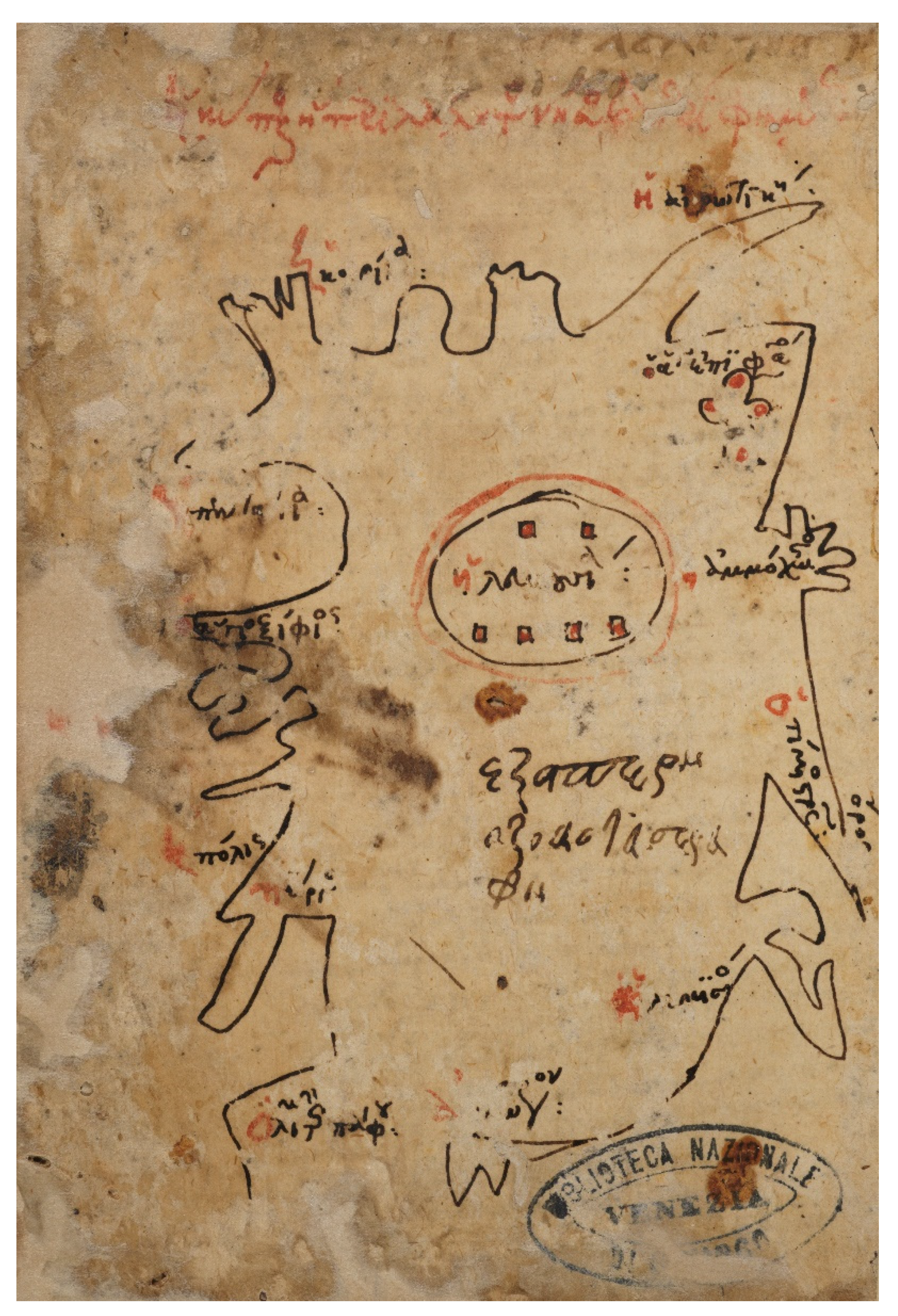
3. The Two Maps of Cyprus of the Fourteenth Century
Two schematically drawn, freehand maps of Cyprus, rare and unique in the Byzantine world, are preserved: the first one in Milan: Biblioteca Ambrosiana, A95 sup., dated to the early fourteenth century, and its copy in Venice: Biblioteca Nazionale Marciana, gr. XI.21 (coll. 453), executed in the middle of the fourteenth century. The two maps were first published by Cronier and Gautier Dalché (2017), and then discussed by Toumpouri (2018). Both maps are preserved in two Greek medical manuscripts which contain various therapeutic recipes and treatises.
3.1. The Ambrosiana Map
The scribe and owner of the manuscript was a physician who copied it for his own use, as the annotations added day by day demonstrate (Cronier and Gautier Dalché 2017, p. 177; Cronier 2020, pp. 131–36). It is important to state that the person who drew the map and added the inscription above it was not necessarily the person who created the manuscript (see below; Figure 1). Based on the marginal notes, the manuscript was produced in Constantinople; then, it was transferred to the emirate of Menteşe in south-western Asia Minor, as its owner had been asked to cure the son of Selman Paşa, a Turkish ruler of the Menteşoğlu dynasty (in the 1330s). Finally, the manuscript arrived in Cyprus (mid-fourteenth century) (Cronier and Gautier Dalché 2017, pp. 177–78).
Figure 1.
The Ambrosiana map of Cyprus. Milan, Ambrosiana MS A95 sup., f. 180r. First half of the fourteenth century (Reproduced with permission from the Veneranda Biblioteca Ambrosiana, Milan).
The map of Cyprus constitutes one of the last additions to the manuscript. It was drawn on the last page (f. 180r), which was probably originally a blank leaf. According to Cronier and Gautier Dalché, the epigram and the sketch of the rabbit were added first, and the map was later drawn around it (Cronier and Gautier Dalché 2017, p. 178). However, we observe that the rabbit and the place-name “Kyrenia” are written in the same red ink (see below). As the placename can only be explained by the presence of the map and as the epigram was fully enclosed within the map, written in pale orange ink, we can suppose that they are all additions to the page after the map was drawn there. The epigram was written by a different hand from that which wrote the note above the map and the map’s toponyms:
Καλὸν πενθεῖν τὰ πταίσμα(τα) μουθρήνησον ἡ κύπρος |ἡ παναθλία | ἐν τὰ τέλη [=τῷ τέλει] τοῦ ἔτους | τοῦ ἀρχομένουIt is good to bewail my sins/Wail, Cyprus, you all-wretched, at the end of the year that begins.(The transcription and translation are of Cronier and Gautier Dalché 2017, p. 178)
Indeed, the first phrase “Καλὸν πενθεῖν τὰ πταίσμα(τα) μου” (“it is good to bewail my sins”) indicates a man who was pious with religious zeal. In addition, the epigram refers to an uncertain misfortune that hit Cyprus. If we accept that the manuscript was in Cyprus in the mid-fourteenth century, it may be implying the Black Death of 1347–48, which hit Cyprus as hard as it had hit most other areas of Europe and the Mediterranean (cf. Papacostas 2018), reducing the population of the island by between one third and one fifth. Moreover, a Turkish attack on the fortress at Kyrenia in December 1347 is attested due to the island’s vulnerable coastline (Papacostas 2018, p. 137). Furthermore, the severe outbreak of Black Death of c.1361–63 was accompanied by Turkish raids on the north coast. According to Leontios Makhairas, the Cypriot chronicler, writing between 1426–32, the Turks were facilitated by the fact that the island was empty and defenceless (Dawkins 1932, §135, §137; Papacostas 2018, p. 137).
The person who drew the map chose to mark mainly coastal sites or places directly related with sea. Therefore, sixteen name-places are recorded. Among them two important shrines and only two sites are cited inland (Nicosia and Kyrenia). Thus, we can read from east to north and from west to south coast: ἡ ἀκρωτική—Karpas peninsula; τὸ χαρπάση—Karpasi (Rizokarpaso); ἡ κοιρΐνϊα—Kyrenia; [ἡ π]εντάγια—Pentayia; ὁ ἅγιος ξΐφϊος—Agios Auxibios; [ἡ π]ό[λις]—Polis Chrysochous; πΰργος—Pyrgos; ὁ λιμὴν τῆς πάφου—Paphos harbour; ἀκρωτ(ή)ρ(ιον)—Akrotiri peninsula; ἡ λεμισός—Limassol; ὄρος ὁ τΐμιος στ(αυ)ρ(ὸ)ς—Stavrovouni monastery; τοῦ ραδΐπου—Aradippou; ἡ αμμόχωστος—Famagusta; ὁ ἅ(γ)ιος ἐπιφάνιος—Agios Epiphanios. The two towns shown in the interior are ἡ κηρινια—Kyrenia and ἡ λευκουσία—Nicosia.
Concerning the toponyms, ἡ ἀκρωτική can be identified with the Karpas peninsula and can be associated with the ancient Greek temple of Aphrodite Akrea, located at the north-eastern end of the peninsula. The epithet “Akrea” refers to something that it is located on the edge; the toponym “Akrotiki” seems to arise from this epithet “Akrea-Akrotiki”. The name “Akrotiki” is attested firstly in Leontios Makhairas (Dawkins 1932, §34, §191, §448, §654). Based on his writing, it is not easy to determine which part of Karpas is implied. Depending on the text context, the name Akrotiki sometimes seems to be situated near the village Agios Andronikos, sometimes at the anchorage Helones (Turtles), which is located between Rizokarpaso and Cape Apostolos Andreas, and sometimes it seems to refer to the area north of Famagusta. The toponym is also preserved in the bilingual text (Italian–Greek) of the “Regulations of Karpas Peninsula Territory”, dated to the 1563 and preserved in the Venetian State Archives. The Italian text noted “Volendo il magnifico Misser Francesco Calergi honoratissimo Balio del Carpasso regger questa contrada.” and its transcription in Greek: «Θέλοντας ο μεγαλοπρεπίς αφεντίς ο Φραντζέσκος Καλλέργις έντιμος εμπαλίς τις Aκρωτίκις να γουβερνιάσι ετούτιν τιν ανορίαν.» (Patapiou 2008, p. 27; Patapiou 2015). Based on the above-mentioned document, the name-place, Akrotiki, can surely be identified with the whole peninsula of Karpas.
Moreover, τὸ χαρπάση refers to the village called Rizokarpaso. The village Karpasi is also observed in medieval written sources; it is known as “casal du Carpas” in Frankish documents and as “casal del Carpasso” in Venetian ones (Patapiou 2015). The name “Risocarpaso” (Rizokarpaso) seems to appear for the first time in the map of Leonidas Attar, dated to 1542 (Cavazzana and Grivaud 2006, p. 97).
Two sites labelled as “Kyrenia” are marked on the map situated not far from each other. The first one is the coastal city and harbour (ἡ κοιρΐνϊα) and the second one (ἡ κηρινια) is located inland and above the city of Nicosia. For the moment, it is difficult to suggest an interpretation concerning the second toponym. However, it is interesting to mention that the second Kyrenia was added later and although the hand is similar, it was written with a different red ink (see above). This was probably a mistake or a misunderstanding of the toponym.
Furthermore, Pyrgos is situated at the west coast of the island and probably corresponds to the tower known by the name of Pyrgos tis Rigainas at the Akamas peninsula (Jeffrey 1983, p. 412; Wallace 1984, pp. 346–47 and Figure 1; Fejfer 1995, p. 60). In Attar’s map of 1542, the tower is cited as “Merovigli” (Cavazzana and Grivaud 2006, pp. 46–47, Figure 30a). The scope of this type of tower was not to protect rural populations; according to medieval tradition, it must have been part of the watch system and it was established by the Byzantines during the rule of Constantine the Great (Dawkins 1932, §6; Cavazzana and Grivaud 2006, pp. 46–47). The different watch towers of the island communicated by means of signals, as Stefano Lusignan noted in the late sixteenth century (De Lusignan 1580, f. 218r).
At a later time, and outside the map’s coastline frame, Aradippou (τοῦ ραδΐπου) was also added. The name cited, τοῦ ραδΐπου, is preserved in medieval sources as “casali de Radipe” (Grivaud 2008, p. 363). Aradippou is associated with King Hugh IV (1324–58), who had a manor house there which he visited every spring. We know that he resided in his manor during the month of March in 1352, 1353 and 1354 (Grivaud 2008, p. 363). The insertion of Aradippou on the map is not entirely surprising; Aradippou was an important village of the area due to the royal manor. The anonymous draughtsman of the map may have added the village after hearing something about it.
It is possible that the person who drew the map arrived in Cyprus at Paphos’ port, as it is the only place-name cited as a port (ὁ λιμὴν τῆς πάφου). Travellers arriving from the Aegean and Asia Minor usually anchored at Paphos’ port. Although Kyrenia, Limassol and Famagusta were also ports—the latter had become the major harbour on the island during late Middle Ages—they were not labelled as such. However, the map drawer, by using iconographic signs, had stated that all these places were ports, i.e., the coastline is shown with projections on the coast.
The peninsula of Akrotiri (ἀκρωτήριον) was also an anchorage, as the delineation on the map indicates. Throughout the centuries, travellers, pilgrims, and refuges arrived from the opposite coast, especially from Alexandria. Akrotiri was famous for its salt lake, which was a major resource to the royal court during the Lusignan period; although, Larnaca’s salt was of better quality and was therefore sold at higher price (Nicolaou-Konnari and Schabel 2015, p. 216).
Pentayia is located at the north coast, near the area of Soloi. The name “Pentayia” may arise from the composition of the words “πέντε άγιοι” (five saints), “πεντάγιοι” and “πεντάγεια” (Jeffrey 1983, p. 224). The village seems to have gained great prosperity during the Lusignan period. It was the administrative centre of the district and one of the twelve baronies of the Kingdom of Cyprus; according to Mas Latrie, it was a royal estate (Mas Latrie 1970, p. 528). The village is also observed in medieval sources; Leontios Makhairas refers to it six different times (Dawkins 1932, §137, §377, §427, §444, §447, §613). The mapmaker may indicate the large bay of Pentayia and not the village; the name is written outside the coastline-frame of the map and within the schematic line which forms the bay. The ships from Asia Minor usually stopped at this bay.
The toponym ὁ ἅγιος ξΐφϊος is located in Pentayia bay. It probably refers to the small port of Agios Efxifios at Soloi and not to the episcopal basilica of Agios Auxibios. Makhairas cites the port of Agios Efxifios (Άγιος Ευξίφης) three times in relation to the Genoese invasion of Cyprus (1373) and the treaty between the Kingdom of Cyprus and the Republic of Genoa signed in 1383 or 1385 (Dawkins 1932, §377 and §613). According to this treaty, the Genoese ships would anchor only in Famagusta and not in other Cypriot ports whose names are mentioned; among them Agios Efxifios. Moreover, the chronicler noted that Helen Palaiologina, who married the King of Cyprus, John II (1432–58), arrived in Cyprus on 2 February 1442 and disembarked at Agios Efxifios (Dawkins 1932, §709). The identification with the episcopal basilica of Agios Auxibios, who was the first bishop of Soloi, seems doubtful. The cult of Agios Auxibios seems to have existed more as a local than as a long-distance pilgrimage destination. According to an archaeological excavation, which is still unfinished, the presence of a smaller core of the saint’s cult seems to exist from the twelfth to the fifteenth century (Nicolaou 2017, p. 83).
Stravrovouni Monastery, or the Mountain of the Holy Cross as it is cited as on the map, was by far the most famous pilgrimage destination for pilgrims, both local and foreign. The monastery stands on the prominent isolated peak (688 m above sea level) called Mount Olympus, near Pyrga village in the district of Larnaca. Its privileged position is also emphasised on the Ambrosiana map; it is indicated by a pointed triangle protruding towards the sea. Its strategic position between Nicosia, Limassol and Larnaca, with a clear view to the south coast of the island, the Mesaoria valley and the Troodos mountains, was often described by pilgrims and travellers.
According to Cypriot tradition, the monastery was founded by St. Helen around 327–29 A.D. On her return journey from Palestine, she left a piece of the cross of the penitent thief and built a small chapel to house it. The Russian monk, Daniel (1106,) first reported Stavrovouni’s association with the legend of St. Helen (Garzaniti 1991, p. 80). During the late Middle Ages, this tradition was still alive; Ludolf of Sudheim noted it in the 1330s (Cobham 1908, p. 19) and Leontios Makhairas described St. Helen’s journey to Cyprus in detail in the fifteenth century (Dawkins 1932, §8). Nevertheless, there is no archaeological evidence to support the legend of St. Helen. Megaw has cited that the earliest architectural phase of the monastery is the triconch sanctuary with a groin vault over the altar (Megaw 1974, p. 61 n.14).
After its foundation, Stavrovouni was occupied by Orthodox monks. The Greek clergy was replaced by the Black Monks, Benedictines from Antioch, around 1240 or 1246. Almost all the pilgrims of the thirteenth and fourteenth century comment on the Benedictine monastery with the Black Monks and the “cross of the good thief”, which became a “topos”. The pilgrimage was probably reinforced by the addition of a series of relics during the fourteenth century, as pilgrims inform us (Cobham 1908, pp. 16, 27, 29, 40). It seems that Stavrovouni was a much-visited pilgrimage goal for fourteenth century travellers; one hundred thousand pilgrims had seen the cross according to Guillaume de Machaut’s estimation (1365—Shirley and Edbury 2001, p. 24). Needless to say, the pilgrimage trade was not affected by the different inhabitants who had the monastery under their domination.
In addition to the cross, and the various relics housed in the monastery, the miracle of the suspended cross was also a major attraction. This miracle was already noted from the early twelve century; the cross was suspended in the air without visible attachment and shook (Cobham 1908, pp. 18, 27, 28, 40; Garzaniti 1991, p. 80). Information about the pilgrimage object is unclear and uncertain. As Makhairas and an Arab chronicler mention, the monastery was destroyed and looted by the Mamluks during the 1426 invasion (Dawkins 1932, §695; Mansouri 2001, p. 129). Moreover, an Arab source informs us that the cross was taken by the Mamluks and that they discovered that it was suspended by springs, which explains its shaking. Nevertheless, some years later, the cross re-emerges in the pilgrims’ notes; Felix Faber recorded in 1483 that he saw the cross and he describes it in detail (Cobham 1908, p. 40). We can assume that the Mamluks may have not taken the large cross, but probably one other cross, or they may have returned it later to the monastery.
The association of Stavrouvouni with the trade routes and sailors of this period is obvious. Ludolf of Sudheim (1330s) noted that the monastery was saluted by seamen, underlining its role as a major navigational landmark; its peak was visible even in bad weather (Cobham 1908, p. 19). Moreover, according to James of Verona (1346), who visited the monastery on his way back to Famagusta from Nicosia, it was particularly venerated by sailors (Cobham 1908, p. 18). For all those who travelled the seas, merchants, pilgrims and ship crews, the reminder of the presence of a sacred place, such as a church or a monastery, was a vital comfort. Through these sacred establishments, travellers could pray to the saint to whom the church was dedicated and ask for the protection of the housed sacred relics. If the travellers landed nearby, they had to visit and pray to thank the saint for allowing them to survive sea dangers.
Ambrosiana’s map also singles out the basilica of Agios Epiphanios, bishop of Constantia (367–403), situated in the area of ancient Salamis (eight kilometres north of Famagusta city). The basilica of Agios Epiphanios is one of the earliest monuments of Christianity in Cyprus and its construction began during the last years of the episcopacy of Epiphanios (cf. Foulias 2019, pp. 719–29). St. Epiphanios was buried in 403 and venerated at his shrines throughout the late antique to medieval period. The draughtsman of the map drew the basilica as a trefoil, evoking the three-aisled barrel-vaulted church with three domes that had been constructed in the eighth century and survived still in the mid-fourteenth century when it was associated with the cult of St. Catherine (cf. Calvelli 2009, pp. 157–245). The citation of the basilica on the map may testify that the saint’s relic was still attested there, for we know his cult was alive between 1345–49 (Hoade 1970, p. 60). Their presence at the basilica in Salamis is also stated by contemporary travellers (see above and Cobham 1908, p. 20). Leontios Makhairas informs us those parts of his relics were circulated within the island during the fourteenth century. Indeed, after the miracle in Tochni (1340), Patriarch Ignatios of Antioch included one of Epiphanios’ relics among the many in the great cross he made in order to be used in processions around the new church against locusts, drought, or plague (Dawkins 1932, §77). Moreover, Epiphanios’ skull was venerated in the Latin cathedral of Nicosia, where a commemoration was instituted in 1357 (Coureas and Schabel 1997, p. 310; Schabel 2001, p. 366). In the sixteenth century, part of his relics was possibly transferred to Famagusta to the church dedicated to Agios Symeon or to Agios Epiphanios which adjoined the large cathedral of Agios Georgios ton Ellinon (St. George of the Greeks) (Kaffenberger 2014, pp. 171–80; Papacostas 2014, pp. 46–50).
We return to the manuscript; above the map a note in seven lines is added, plausibly by the same hand who drew the map. The hand is similar but not identical to the copyist of the main text of the manuscript (Cronier and Gautier Dalché 2017, p. 178). It is possible that the man who wrote the note and executed the map was the copyist himself, but at an older age.
[Εἰς τὴν] Κύπρον εἰς τὸ ὄρος αὐτῆς ἐν τῇ μονῇ |[ τῆς π]ανϋπεράγνου μοῦ θεομήτ(ο)ρος τῆς ἐπονομαζομένης | [εἰς?] Κίκον, παρέδωκα τὸν ἐκεῖσε πν(ευματ)ικὸν τὸν | [Γερ?]μανὸν, βιβλία ἰατρικὰ δύο· τὸ ἓν μετὰ |[ σ]ανιδίων καὶ τομαρίου, καὶ τὸ ἕτερον οὕτως· ζύγιον καλὸν· | ὑαλίον ὥσπερ βατζέλ(η) ἀλεξανδρείν(η)· καὶ εἴδη ια|τρικὰ μετὰ χαρτοσακούλου.
In Cyprus, upon its mountain, in the monastery of the All-Saint Mother of God called [at?] Kykkos, I gave to the spiritual father [Ger]manos, two medicine’s books; the one with wooden boards covered with leather, and the other too; good scales; a glass jar, like the Alexandrian vessel; and medical utensils, with a paper bag (The transcription and translation are of Cronier and Gautier Dalché 2017, p. 178).
The note informs us about a transaction with the Monastery of the Virgin of Kykkos in Cyprus (Figure 2). The anonymous man gave two medical manuscripts and other medical materials (scales for weighting ingredients, a transparent glass jar, and a bag with small medical implements) to the monk of the monastery, Germanos, who was also a “pneumatikos” (spiritual father). The monk was probably a physician. The person who gives this medical equipment was probably a doctor and could have been the original maker of the manuscript. However, we have no evidence to declare that he was the same physician who made the book.
Figure 2.
Map of Cyprus with toponyms and sites cited in Ambrosiana Map (Map by Niki Kyriacou).
Based on the information at our disposal, we can assume that the initial owner of the manuscript was from Constantinople (Cronier 2020, p. 132). This man was probably a well-known physician as he had been asked to give his medical services to the son of a ruler at Menteşe (Cronier 2020, pp. 133–34). After Asia Minor, the manuscript continued its journey to Cyprus. As mentioned above, we do not know if the original scribe of the book was the same person who possessed the manuscript in Cyprus. Although previous studies (Cronier and Gautier Dalché 2017, p. 180) have presumed that the person who owned the manuscript in Cyprus created this unique map, drawing it free-hand as his own work, we can raise the hypothesis that the Ambrosiana map was probably inspired by a sailing chart and it does not record a personal journey. The anonymous man may have found the map on the ship during his journey to Cyprus and he may have copied it. This type of map, the later so-called portolan, was taken to sea and was regarded as a practical aid for navigation, perhaps with the help of dividers. Moreover, they may have served mostly as a simple aide-mémoire, a handy guide to the features of coasts (Harvey 1991, p. 45). Our map seems to be based on a chart of Cyprus, used in navigation as it emphasised the coastal line of the island. The many coastal place-names cited on the map are mainly written on the land side of the coastline as not to obscure possible danger points. The Ambrosiana map also presents some navigational landmarks such as Stavrovouni Monastery and only one inland feature is shown; as mentioned, only the capital city of the island. Tony Campbell has stated about maritime maps: “the names, written inland and at right angles to the coast, run in a continuous sequence which presents some ‘upside down’, whichever way the cart is turned” (Campbell 1984, p. 48). All the above-mentioned features are observed both on sailing charts and on the Ambrosiana map (cf. Harvey 1991, pp. 39–49). However, our map drawer chose not to copy the so-called rhumb lines that usually cover the portolan maps. If our hypothesis is correct, the Ambrosiana map reflects how the nautical community in general saw the island in the late Middle Ages. Certainly, our map was drawn as a copy and never meant to be taken to sea. Moreover, it is interesting to note that each place that is marked on the map has pilgrimage significance (cf. Section 4 of this article). Nevertheless, the question arises as to why the anonymous man copied the map. Perhaps, he was a multifaceted personality with travelling interests. It is also possible that the anonymous man was planning to visit the Holy Land as a pilgrim and made a stopover to the island. However, there is insufficient evidence to confirm this suggestion. The iconographic symbols used for Agios Epiphanios (trefoil referring to the three-domed basilica), and Nicosia (circle with six small squares implying the medieval city walls), were perhaps copied from the initial map. However, it is still unknown if he visited these places and then added the icons. Certainly, the anonymous man had various interests and curiosities (physician, draughtsman of a map, pilgrim?) and so it would seem that he was by no means an ordinary medieval man. This observation gives us more details about the travellers arriving in Cyprus during the late Middle Ages.
Concerning Kykkos Monastery, the following questions arise: When did the anonymous man become informed about Kykkos Monastery? Did he visit Kykkos as a pilgrim? Was it there that he met Germanos, or did Germanos himself invite him to the monastery? It is worth mentioning that Kykkos may have not been a well-known monastery; it was a monastic establishment in the Troodos mountains with a regional impact. Thus, it is possible that the physician learned about Kykkos on the boat or when he arrived at Paphos and that he probably went to Kykkos as a pilgrim. During his visit, he met Germanos and he gave medical books to the monastery as well as other medical materials. We suppose that all these things were sold or exchanged with something else as the verb “παρέδωκα” (παραδίδωμι) means “give”, “hand over to another”, “transmit”. If it was a donation, we suppose that he would have specified this. If the above-mentioned hypothesis is correct, then Germanos or the monastic community of Kykkos must have had some financial capacity. There can be no doubt that the Ambrosiana manuscript was one of the two books that the anonymous man had given to Germanos and that he wrote this note above the map as a reminder of the affair. It is difficult to determine the exact time period when this action took place. It is worth remembering that in June 1365, Kykkos was destroyed by a fire that broke out near the monastery. The monastery was rebuilt by December that same year, thanks to the donation of Eleanor, the wife of King Peter I (1359–69) (cf. Roudometof and Michael 2010, p. 58). Thus, this transaction should have taken place either before the fire, as we do not know its extent, or after that. It is more likely that this event took place after the fire because in this fire, all the books of Kykkos were probably burned, which led the monk Gregorios to write a new description of Kykkos monastery.
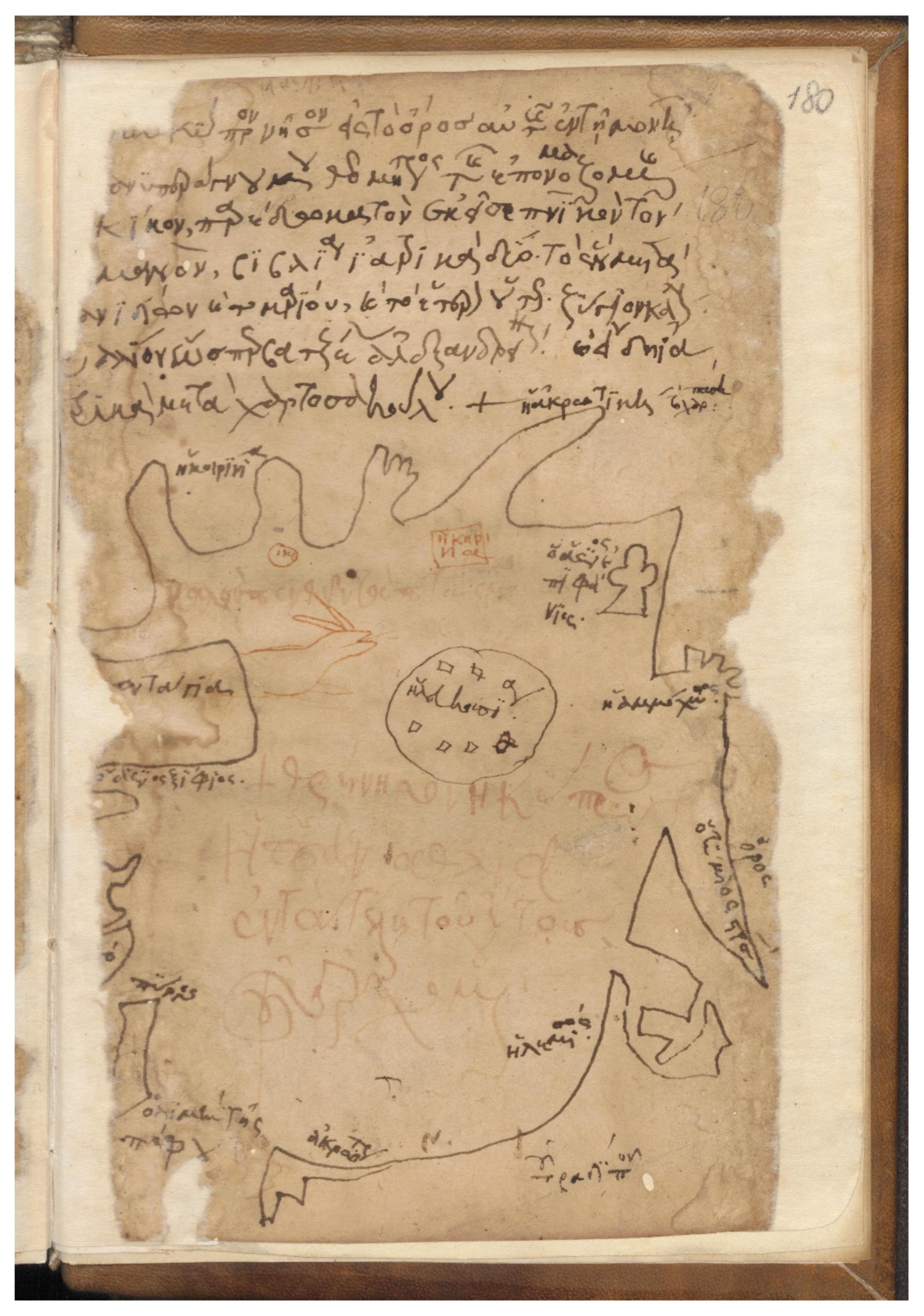
3.2. The Marciana Map
The Marciana manuscript was probably copied in Cyprus; the type of paper used for the manuscript is oriental paper, which was very common on the island in the mid-fourteenth century (Cronier and Gautier Dalché 2017, p. 180). The Marciana manuscript reproduces the Ambrosiana manuscript closely. In particular, the map is copied on the last page of the manuscript (f. 166v) and presents some changes (Figure 3). The city of Kyrenia appears only once; the copyist marked only the correct coastal city. The villages of Aradippou and Karpasi have disappeared. Moreover, all the other notes (epigram and text above the map) are not copied. The two villages were placed quite far from the coastal frame-line determining the map on the Ambrosiana manuscript and the second place named Kyrenia is written with the same red ink as the epigram inside the map; therefore, one wonders if those place-names had escaped the attention of the copyist or if there was no reason for him to copy them. Furthermore, the note above the map referred to the previous manuscript and its removal is reasonable. At the same time, the anonymous copyist added a title above the map:
Κύπρος η περιλάλητος νήσος και περίφημος“Cyprus, the so famous and so celebrated island”.(The transcription and translation are of Cronier and Gautier Dalché 2017, p. 180)
Figure 3.
The Marciana map of Cyprus. Venice, Biblioteca Nazionale Marciana, gr. XI.21, f. 166v. Mid-fourteenth century (Reproduced with permission from the Biblioteca Nazionale Marciana, Venice).
The insertion of the title in the above map makes clear that the copyist intended to celebrate and glorify the island, probably his island. He erased the note from the initial manuscript (Ambrosiana manuscript) that labelled Cyprus as “παναθλία” (very miserable) and replaced it with the words “περιλάλητος” (so famous) and “περίφημος” (so celebrated).
We suppose that the Marciana manuscript must have been copied at the monastery of Kykkos, as the monastery preserved a scriptorium during the Middle Ages (Yakovlevich 2010). According to the manuscript of Timios Stavros n.111 preserved at the Library of the Patriarch of Jerusalem, the monk Symeon completed the copying of a Psalter at Kykkos monastery in 1472, while the expenses were covered by the priest, Basil Chamados, who was the donor of the church of Archangelos Michail at Pedoulas (Perdikis 2014, p. 73). The speed at which the Ambrosiana’s book was copied is remarkable. As a book with medical content, it was perhaps a greatly desired book and was, therefore, immediately copied. On the other hand, it may have been an order.
5. Concluding Remarks
This article has aimed to examine the connectivity of Cyprus as a focal point of movement, sometimes more intense, sometimes more restricted, during the late Middle Ages. Through this navigation, a number of pilgrimage sites were developed, reflecting the diversity of travellers who came to the island.
The unique freehand map of Cyprus preserved on a medical manuscript was created by an unknown “cosmopolitan” man. The history of the manuscript and its owner is quite interesting, as this man seemed to have a varied career and relationships. The map indicates the maritime centres of the island, which constituted religious and economic centres of the late Middle Ages. It seems to be copied; the owner of the manuscript at that time is not the creator of this map. It is more plausibly a nautical map which gave sailing information. Its importance lies in the fact that, for the first time, the sea voyage and maritime routes which had Cyprus as a stopover during the late Middle Ages, are captured. Moreover, it gives precious information about the coastal line of the island, the holy names, and the toponyms. Needless to say, this map comprises a unique document and offers novel insights into fourteenth century Cyprus. We hope that future research may bring to light more information about these two maps and manuscripts in general.
It is unsurprising that from the fourteenth century onwards, the increase in mobility for trade or/and pilgrimage reasons in the Eastern Mediterranean basin developed the island as a major stopover, which was accompanied by the establishment of a network of new shrines associated with the maritime itineraries. This connectivity is also expressed through a pre-modern series of ship graffiti, dated from the sixteenth century and preserved in churches mainly located in the areas between Famagusta and Larnaca; it has been suggested that they were executed by travellers who wished to disembark and visit shrines which were located on routes that connected the two major ports of the island (Walsh 2007; Michael 2015; Demesticha et al. 2017). The loca sancta discussed in the article were linked directly or indirectly with water, which was a precious liquid for ships’ supplies and also a precious and holy liquid (hagiasma) for religious practices. The majority of maritime pilgrimage sites preserved this miraculous-therapeutic holy water (hagiasma) and provided their visitors with fresh water which was important for their physical survival. Furthermore, most of the coastal shrines were venerated by more than one religious community (Greek, Latins, other denominations of Christianity). The phenomenon of “mixed” or “shared” shrines is not only observable in Cyprus; it is a well-established phenomenon in the Mediterranean area where different religious groups have lived from the medieval past to modern times (cf. Alberta 2012; Couroucli 2014). The presence of different religious groups in the same shrine did not mean that there is no religious or cultural diversity between them. Moreover, the “establishment” of Latin orders in Greek churches, located mainly near coast and ports, may be interpreted in the context of better service and economic exploitation of the Latin pilgrims/travellers. It is difficult to assess the exact role of these maritime shrines within the island. Undoubtedly, they served as a source of revenue and benefited the whole surrounding area, not only from donations but also because of the many people attracted by the shrine. This category of shrines, referred to as “maritime” pilgrimage sites, is clearly related with seamen and it is distinguished from other Cypriot sacred sites located mainly inland. Their connection to the sea routes and sailors gives them a more cosmopolitan air, removes them partly from their local dimension, and integrates them into a wide network of maritime communication.
Funding
This article is part of the research project “The Spatiality and Materiality of Pilgrimage in Byzantine and Medieval Cyprus and Religious Networks in the Eastern Mediterranean (11th–16th century)—SpaMaP Cy” (Restart 2016-20, DIDAKTOR, POST-DOC/0916/0251), co-funded by the European Regional Development Fund and the Republic of Cyprus, through the Cyprus Research and Innovation Foundation, and hosted by the Archaeological Research Unit, University of Cyprus.
Institutional Review Board Statement
Not applicable.
Informed Consent Statement
Not applicable.
Data Availability Statement
Not applicable.
Acknowledgments
I wish to extend my special thanks to the editors and reviewers for their comments and suggestions. Many thanks also go to Annemarie Weyl Carr, Andreas Foulias and Stylianos Perdikis for their valuable help.
Conflicts of Interest
The author declares no conflict of interest. The funders had no role in the design of the study; in the collection, analyses, or interpretation of data; in the writing of the manuscript, or in the decision to publish the results.
References
- Alberta, Dionigi. 2012. Crossing the Frontiers between the Monotheistic Religions, an Anthropological Approach. In Sharing Sacred Spaces in the Mediterranean. Christians, Muslims, and Jews and Shrines and Sanctuaries. Edited by Dionigi Albera and Maria Couroucli. Bloomington and Indianapolis: Indiana University Press, pp. 219–44. [Google Scholar]
- Bacci, Michele. 2004. Portolano Sacro. Santuari e immagini sacre lungo le rotte di navigazione del Mediterraneo tra tardo Mediovo e prima età moderna. In The Miraculous Image in the Middle Ages and Renaissance. Edited by Erik Thuno and Gerhard Wolf. Rome: L’Erma di Bretschneider, pp. 223–48. [Google Scholar]
- Bacci, Michele. 2009. Mixed’ Shrines in Late Byzantine Period. In Archaeologia Abrahamica. Studies in Archaeology and Artistic Tradition of Judaism, Christianity and Islam. Edited by Leonid Beliaev. Moscow: Russian Academy of Sciences Institute of Archeology, pp. 433–44. [Google Scholar]
- Bacci, Michele. 2014. On the Topography of Sailors: An Introduction. In The Holy Portolano. The Sacred Geography of Navigation in the Middle Ages. Edited by Michele Bacci and Martin Rohde. Berlin, Munich and Boston: De Gruyter, pp. 7–16. [Google Scholar]
- Bacci, Michele. 2016. Shaping the Holy Topography of Saint Catherine in the Late Middle Ages. In At Home in Art: Essays in Honor of Mario Buhagiar. Edited by Charlene Vella. Malta: Midsea Books, pp. 3325–88. [Google Scholar]
- Bacci, Michele. 2019. A Holy Site for Sailor: Our Lady of the Cave in Famagusta. In Famagusta Maritima. Mariners, Merchants, Pilgrims and Mercenaries. Edited by Michael J. K. Walsh. Leiden and Boston: Brill, pp. 43–71. [Google Scholar]
- Balard, Michel. 1993. Mercanti-viaggiatori a Cipro nel Quattrocento. In Relazioni di viaggio e conoscenza del mondo fra Medioevo e Umanesimo: Atti del 5. convegno internazionale di studi dell’Associazione per il Medioevo e l’Umanesimo Latini (AMUL), Genova, 12–15 dicembre 1991. Edited by Stefano Pittaluga. Genova: Università di Genova, pp. 271–82. [Google Scholar]
- Borowski, Tomasz. 2018. Religion and Conflict: Investigating the Role of Relics and Holy Sites in the Religiously Diverse Society of Crusader Famagusta, Cyprus. In Crusading in Art, Thought and Will. Edited by Matthew E. Parker, Ben Halliburton and Anne Romine. Leiden and Boston: Brill, pp. 68–109. [Google Scholar]
- Burkiewicz, Łukasz. 2018. Cyprus est terra Christianorum ultima. Wielokulturowy Cypr w oczach Polaków pielgrzymujących do Ziemi Świętej (do 1878 roku). In Terra culturae. Obszary, transfery, recepcje kultury. Studia oraz szkice o kulturze i historii. Edited by Łukasz Burkiewicz. Krakow: Wydawnictwo Akademii Ignatianum w Krakowie, Wydawnictwo WAM, pp. 209–44. [Google Scholar]
- Calvelli, Lorenzo. 2009. Cipro e la memoria dell’Antico fra Medioevo e Rinascimento. La percezione del passato romano dell’isola nel mondo occidentale. Venice: Istituto Veneto di Scienze, Lettere ed Art. [Google Scholar]
- Calvelli, Lorenzo. 2014. Cypriot origins, Constantinian blood: The legend of the young Saint Catherine of Alexandria. In Identity/Identities in Late Medieval Cyprus; Edited by Tassos Papacostas and Guillaume Saint-Guillain. Nicosia: Cyprus Research Centre, pp. 361–90. [Google Scholar]
- Campbell, Tony. 1984. Cyprus and the medieval portolan charts. Κυπριακαί Σπουδαί 48: 47–66. [Google Scholar]
- Carr, Annemarie Weyl. 1995. Byzantines and Italians on Cyprus: Images from Art. Dumbarton Oaks Papers 49: 239–74. [Google Scholar] [CrossRef]
- Cavazzana, Francesca Romanelli, and Gilles Grivaud. 2006. Cyprus 1542. The Great Map of the Island by Leonida Attar. Nicosia: Bank of Cyprus Cultural Foundation. [Google Scholar]
- Christofi, Polina. 2020. The Palimpsest under the Monument: Revisiting the Medieval Monastery of Ayia Napa in the Light of New Evidence. In Third International Conference on Byzantine and Medieval Studies, 17–19 January 2020. Abstracts of Presentations. Edited by Christina Kakkoura and Andreas Foulias. Nicosia: Keramos, p. 27. [Google Scholar]
- Translated and Edited by Claude D. Cobham. 1908, Excerpta Cypria: Materials for a History of Cyprus. Cambridge: University Press.
- Constantinides, Costas N., and Robert Browning. 1993. Dated Greek Manuscripts in Cyprus to the Year 1570; Washington, DC and Nicosia: Dumbarton Oaks Research Library and Collection and Cyprus Research Centre.
- Coureas, Nicholas. 2005. Economy. In Cyprus: Society and Culture 1191–1374. Edited by Angel Nicolaou-Konnari and Chris Schabel. Leiden and Boston: Brill, pp. 129–56. [Google Scholar]
- Coureas, Nicholas. 2010. The Latin Church in Cyprus, 1313–1378; Nicosia: Cyprus Research Centre.
- Coureas, Nicholas. 2017. The Lusignan Kingdom of Cyprus and the Sea, 13th–15th centuries. In The Sea in History. The Medieval World. Edited by Christine Buchet and Michel Balard. Woodbridge: Boydell and Brewer, pp. 369–81. [Google Scholar]
- Coureas, Nicholas, and Christopher Schabel, eds. 1997. The cartulary of the Cathedral of Holy Wisdom of Nicosia; Nicosia: Cyprus Research Centre.
- Couroucli, Maria. 2014. Shared Sacred Places. In A Companion to Mediterranean History. Edited by Peregrine Horden and Sharon Kinoshita. Malden and Oxford: Wiley-Blackwell, pp. 378–91. [Google Scholar]
- Cronier, Marie. 2020. Quelques manuscrits médicaux grecs liés à Chypre. In Griechisch-Byzantinische Handschriftenforschung. Traditionen, Entwicklungen, neue Wege. Edited by Christian Brockmann, Daniel Deckers, Dieter Harlfinger and Stefano Valente. Berlin and Boston: De Gruyter, pp. 131–43. [Google Scholar]
- Cronier, Marie, and Patrick Gautier Dalché. 2017. A Map of Cyprus in Two Fourteenth-Century Byzantine Manuscripts. Imago Mundi 69: 176–87. [Google Scholar] [CrossRef]
- Davis, Stephen J. 2001. The Cult of Saint Thecla: A Tradition of Women’s Piety in Late Antiquity. Oxford: Oxford University Press. [Google Scholar]
- Dawkins, Richard M., ed. 1932. Leontios, Makhairas, Recital Concerning the Sweet Land of Cyprus, Entitled ‘Chronicle’. Oxford: Clarendon Presse, vol. I. [Google Scholar]
- De Lusignan, Estienne. 1580. Description de toute l’isle de Chypre. repr. 2004. Paris: Guillaume Chaudiere, Nicosia: Cultural Foundation of the Bank of Cyprus. [Google Scholar]
- Delatte, Armand. 1947. Les portulans grecs. Liege: Bibliothèque de la Faculté de Philosophie et des Lettres de l’Université de Liége. [Google Scholar]
- Deligiannakis, Georgios. 2018a. The Last Pagans of Cyprus: Prolegomena to a History of Transition from Polytheism to Christianity. In Church Building in Cyprus (Fourth to Seventh Centuries). A Mirror of Intercultural Contacts in the Eastern Mediterranean. Edited by Marietta Horster, Doria Nicolaou and Sabine Rogge. Münster: Waxmann, pp. 23–44. [Google Scholar]
- Deligiannakis, Georgios. 2018b. From Aphrodite(s) to Saintly Bishops in Late Antique Cyprus. In Authority and Identity in Emerging Christianities in Asia Minor and Greece. Edited by Cilliers Breytenbach and Julien M. Ogereau. Leiden and Boston: Brill, pp. 326–46. [Google Scholar]
- Demesticha, Stella, Katerina Delouca, Mia Gaia Trentin, Nikolas Bakirtzis, and Antonis Neophytou. 2017. Seamen on Land? A Preliminary Analysis of Medieval Ship Graffiti on Cyprus. The International Journal of Nautical Archaeology 46: 346–81. [Google Scholar] [CrossRef]
- Deycks, Ferdinand, ed. 1851. Ludolph von Sudheim, Ludolphi de itinere Terrae Sanctae liber (1335–1341). Stuttgart: Litteraricher Verein. [Google Scholar]
- Dopp, Pierre-Herman, ed. 1958. Emmanuel Piloti, Traité d’Emmanuel Piloti sur le passage en Terre Sainte (1420). Louvain: Nauwelaerts. [Google Scholar]
- Fejfer, Jane, ed. 1995. Ancient Akamas I. Settlement and Environment. Aarhus: Aarhus University Press. [Google Scholar]
- Foulias, Andreas. 2019. The Basilica of Saint Epiphanios: Architecture and Chronology. In Salamis of Cyprus. History and Archaeology from the Earliest Times to Late Antiquity. Edited by Sabine Rogge, Christina Ioannou and Theodoros Mavrojannis. Münster: Waxmann, pp. 719–29. [Google Scholar]
- Foulias, Andreas. 2020. Oι απαρχές της μονής. In H Ιερά Μονή του Aποστόλου Aνδρέα στην Καρπασία. Edited by Christodoulos Hadjichristodoulou and Andreas Foulias. Nicosia: Holy Diocese of Karpasia, pp. 71–102. [Google Scholar]
- Foulias, Andreas. 2021. Aσκητήρια της επαρχίας Aμμοχώστου. In Κυπριακή Aγιολογία. Πρακτικά Β΄ Διεθνούς Συνεδρίου. Παραλίμνι, 13–15 Φεβρουαρίου 2014. Edited by Theodoros Giagkou, Christina Kakkoura, fr. Christodoulos Christodoulou and fr. Nikolaos Papantoniou. Agia Napa and Paralimni: Holy Diocese of Konstantia and Ammochostos, pp. 678–735. [Google Scholar]
- Garzaniti, Marcello, ed. 1991. Daniil Egumeno, Itinerario in Terra Santa. Rome: Città Nova Editrice. [Google Scholar]
- Grivaud, Gilles, ed. 1990. Excerpta Cypria Nova. Volume Premier: Voyageurs occidentaux à Chypre au XVème Siècle; Nicosia: Cyprus Research Centre.
- Grivaud, Gilles. 2008. A propos du manoir dans l’Orient latin: Le cas du royaume de Chypre (XIIIe–XVe siècle). In Des châteaux et des sources. Archéologie et histoire dans la Normandie médiévale. Edited by Jean-Louis Roch, Bruno Lepeuple and Elisabeth Lalou. Mont-Saint-Aignan: Presses universitaire de Rouen et du Havre, pp. 353–74. [Google Scholar]
- Hadjichristodoulou, Christodoulos, and Andreas Foulias. 2017. Εκκλησιαστικά μνημεία της Λυσού. Nicosia: Keramos. [Google Scholar]
- Hadjikyriakou, Antonis. 2017. Envisioning Insularity in the Ottoman World. Princeton Papers: Interdisciplinary Journal of Middle Eastern Studies 18: vii–xix. [Google Scholar]
- Harvey, Paul D. A. 1991. Medieval Maps. London: The British Library. [Google Scholar]
- Hoade, Eugene. 1970. Western Pilgrims. The Itineraries of Fr. Simon Fitzsimons (1322–23), a Certain Englishman (1344–45), Thomas Brygg (1392), and Notes on Other Authors and Pilgrims. Jerusalem: Franciscan Printing Press. [Google Scholar]
- Jacoby, David. 2014. Refugees from Acre in Famagusta around 1300. In The Harbour of All this Sea and Realm. Crusader to Venetian Famagusta. Edited by Michael J. K. Walsh, Tamás Kiss and Nicholas S. H. Coureas. Budapest: Central European University Press, pp. 53–67. [Google Scholar]
- Jacoby, David. 2016. Evolving routes of Western pilgrimage to the Holy Land, eleventh to fifteenth century: An overview. In Unterwegs im Namen der Religion II/On the Road in the Name of Religion II. Edited by Klaus Herbers and Hans Christian Lehner. Stuttgart: Franz Steiner, pp. 75–97. [Google Scholar]
- Jeffrey, George. 1983. A Description of the Historic Monuments of Cyprus: Studies in the Archaeology and Architecture of the Island. London: Zeno Booksellers and Publishers. [Google Scholar]
- Kaffenberger, Thomas. 2014. Harmonizing the Sources: An Insight into the Appearance of the Hagios Georgios Complex at Various Stage of its Building History. In The Harbour of All This Sea and Realm. Crusader to Venetian Famagusta. Edited by Michael J. K. Walsh, Tamás Kiss and Nicholas S. H. Coureas. Budapest: Central European University Press, pp. 169–90. [Google Scholar]
- Lusignano, Steffano. 1573. Chorograffia. repr. 2004. Bologna: Alesandro Benaccio, Nicosia: Museum of the Holy Monastery of Kykkos. [Google Scholar]
- Mansouri, Mohamed Tahar. 2001. Chypre dans les sources arabes médiévales; Nicosia: Cyprus Research Centre.
- Maraval, Pierre. 1985. Lieux saints et pèlerinages d’Orient. Histoire et géographie des origins à la conquête arabes. Paris: Cerf. [Google Scholar]
- Maraval, Pierre. 1996. Récits des premiers pèlerins chrétiens au Proche-Orient (IVe-VIIe s.). Paris: Cerf. [Google Scholar]
- Mas Latrie, Louis. 1970. Histoire de l’île de Chypre: Sous la règne des princes de la maison de Lusignan. Famagusta: Les éditions L’Oiseau, vol. III. [Google Scholar]
- Megaw, Arthur H. S. 1974. Architecture and Decoration in Cyprus: Metropolitan or Provincial? Dumbarton Oaks Papers 28: 57–88. [Google Scholar] [CrossRef]
- Michael, Maria. 2015. Ship graffiti in context: A preliminary study of Cypriot patterns. In Cypriot Cultural Details, Proceedings of the 10th Post Graduate Cypriot Archaeology Conference. Edited by Iosif Hadjikyriakos and Mia Gaia Trentin. Oxford and Philadelphia: Oxbow Books, pp. 41–64. [Google Scholar]
- Mogabgab, Theophilus. 1951. Excavations and Researches in Famagusta, 1937–1939. Report of the Department of Antiquities Cyprus 1937–1939 181: 190. [Google Scholar]
- Nicolaou, Doria. 2017. Νέα ερμηνευτική πρόταση και αναχρονολόγηση του παλαιοχριστιανικού συγκροτήματος των Σόλων. Deltion of the Christian Archaeological Society 38: 57–86. [Google Scholar]
- Nicolaou, Doria. Forthcoming. Νέα στοιχεία για την οικοδομική ιστορία του μεσαιωνικού παρεκκλησίου του Aποστόλου Aνδρέα μέσα από τις πρόσφατες αρχαιολογικές έρευνες. In Πρακτικά Γ΄ Ετήσιου Επιστημονικού Συνεδρίου, 150 χρόνια από τα εγκαίνια του καθολικού της Ιεράς Μονής Aποστόλου Aνδρέα στην Καρπασία, 3–4 Νοεμβρίου 2017. Edited by Andreas Foulias. Nicosia: Theological School of Church of Cyprus.
- Nicolaou-Konnari, Angel, and Chris Schabel. 2015. Limassol under Latin rule, 1191–1571. Lemesos. In A History of Limassol in Cyprus from Antiquity to the Ottoman Conquest. Edited by Angel Nicolaou-Konnari and Chris Schabel. Newcastle upon Tyne: Cambridge Scholars Publishing, pp. 195–361. [Google Scholar]
- Olympios, Michalis. 2013. Shared Devotions: Non-Latin Responses to Latin Sainthood in Medieval Cyprus. Journal of Medieval History 39: 321–41. [Google Scholar] [CrossRef]
- Olympios, Michalis. 2015. Rummaging through Ruins: Architecture in Limassol in the Lusignan and Venetian periods. In A History of Limassol in Cyprus from Antiquity to the Ottoman Conquest. Edited by Angel Nicolaou-Konnari and Chris Schabel. Newcastle upon Tyne: Cambridge Scholars Publishing, pp. 362–500. [Google Scholar]
- Papacostas, Tassos. 2014. Byzantine Famagusta: An Oxymoron? In Famagusta. Volume I: Art and Architecture. Edited by Annemarie Weyl Carr. Turnhout: Brepols, pp. 25–61. [Google Scholar]
- Papacostas, Tassos. 2015. Neapolis/Nemesos/Limassol: The rise of a Byzantine Settlement from Late Antiquity to the time of the Crusades. In A History of Limassol in Cyprus from Antiquity to the Ottoman Conquest. Edited by Angel Nicolaou-Konnari and Chris Schabel. Newcastle upon Tyne: Cambridge Scholars Publishing, pp. 96–188. [Google Scholar]
- Papacostas, Tassos. 2018. Manuscript Notes and the Black Death in Rural Cyprus. In Reading in the Byzantine Empire and Beyond. Edited by Teresa Shawcross and Ida Toth. Cambridge: Cambridge University Press, pp. 133–55. [Google Scholar]
- Papageorghiou, Athanasios. 1998. O ναός του Aγίου Λαζάρου Λάρνακα. Report of the Department of Antiquities Cyprus, 205–24. [Google Scholar]
- Papageorghiou, Athanasios. 2010. H χριστιανική τέχνη στο κατεχόμενο από τον τουρκικό στρατό τμήμα της Κύπρου. Nicosia: Holy Archbishopric of Cyprus. [Google Scholar]
- Papantoniou, Giorgos. 2012. Religions and Social Transformation in Cyprus. From the Cypriot Basileis to the Hellenistic Strategos. Leiden and Boston: Brill. [Google Scholar]
- Papantoniou, Giorgos. 2016. Cypriot Ritual and Cult from the Bronze to the Iron Age: A longue-durée approach. Journal of Greek Archaeology 1: 73–108. [Google Scholar]
- Patapiou, Nasa. 2006. Leonardo Donà, Memorie per le cose di Cipro: From the City of Shoal Waters to Outermost Karpasia. In “Sweet Land…” Lectures on the History and Culture of Cyprus. Edited by Julian Chrysostomides and Charalambos Dendrinos. Camberley: Porphyrogenitus, pp. 206–30. [Google Scholar]
- Patapiou, Nasa. 2008. Κανονισμοί του διαμερίσματος Καρπασίας. Ένα μνημείο της κυπριακής διαλέκτου του έτους 1563. Επιστημονική Επετηρίς της Κυπριακής Εταιρείας Ιστορικών Σπουδών 9: 23–28. [Google Scholar]
- Patapiou, Nasa. 2015. H βυζαντινή ονομασία της χερσονήσου Καρπασίας. In A’ [H’] Συνάντηση Ελλήνων Βυζαντινολόγων. Περιλήψεις ανακοινώσεων, 16–18 Δεκεμβρίου 2015. Athens: National and Kapodistrian University of Athens—National Hellenic Research Foundation, p. 66. [Google Scholar]
- Perdikis, Stylianos. 2014. O ναός του Aρχαγγέλου Μιχαήλ στον Πεδουλά. Nicosia: Cultural Foundation of the Bank of Cyprus and Holy Bishopric of Morphou. [Google Scholar]
- Petras, Guido. 2019. A Stone Iconostasis in a Multi-Confessional Sanctuary in Lusignan and Venetian Cyprus? An Art-Historical Approach to the Cave Church in Agia Napa. In The Art and Archaeology of Lusignan and Venetian Cyprus (1192–1571). Edited by Michalis Olympios and Maria Parani. Turnhout: Brepols, pp. 145–68. [Google Scholar]
- Prefát z Vlakanov, Oldřich. 2014. Cesta z prahy do benátek a odtud potom po moři až do palestyny. Prague: Mĕstská knihovna v Praze, Available online: http://web2.mlp.cz/koweb/00/04/06/10/86/cesta_z_prahy_do_benatek.pdf (accessed on 27 September 2021).
- Preiser-Kapeller, Johannes. 2015a. Harbours and Maritime Networks as Complex Adaptive Systems—A Thematic Introduction. In Harbours and Maritime Networks as Complex Adaptive Systems. Edited by Johannes Preiser-Kapeller and Falko Daim. Mainz: Römisch-Germanisches Zentralmuseum, pp. 1–24. [Google Scholar]
- Preiser-Kapeller, Johannes. 2015b. Harbours and Maritime Mobility: Networks and Entanglements. In Harbours and Maritime Networks as Complex Adaptive Systems. Edited by Johannes Preiser-Kapeller and Falko Daim. Mainz: Römisch-Germanisches Zentralmuseum, pp. 119–40. [Google Scholar]
- Preiser-Kapeller, Johannes, and Lukas Werther. 2018. Connecting Harbours. A Comparison of Traffic Networks across Ancient and Medieval Europe. In Harbours as Objects of Interdisciplinary Research: Archaeology + History + Geosciences. Edited by Claus von Carnap-Bornheim, Falko Daim, Peter Ettel and Ursula Warnke. Mainz: Römisch-Germanisches Zentralmuseum, pp. 7–31. [Google Scholar]
- Ritter, Max. 2019. Famagusta and its Environs in the Venetian period: The foundation of the monastery of Agia Napa and the origins of its fountain. In The Art and Archaeology of Lusignan and Venetian Cyprus (1192–1571). Edited by Michalis Olympios and Maria Parani. Turnhout: Brepols, pp. 125–44. [Google Scholar]
- Roudometof, Victor, and Michalis N. Michael. 2010. Economic Functions of Monasticism in Cyprus: The Case of the Kykkos Monastery. Religions 1: 54–77. [Google Scholar] [CrossRef] [Green Version]
- Ruzzin, Valentina. 2013. La Bonna Parolla. Il portolano sacro genovese. Atti della Società ligure di storia patria 53: 21–59. [Google Scholar]
- Translated and Edited by Chris Schabel. 2001, The Synodicum Nicosiense and Other Documents of the Latin Church of Cyprus, 1196–1373; Nicosia: Cyprus Research Centre.
- Schabel, Chris. 2005. Religion. In Cyprus: Society and Culture 1191–1374. Edited by Angel Nicolaou-Konnari and Chris Schabel. Leiden and Boston: Brill, pp. 157–218. [Google Scholar]
- Janet Shirley, trans. 2001, Edbury, Peter W., ed. Guillaume de Machaut, Guillaume de Machaut: The capture of Alexandria. London and New York: Routledge. [Google Scholar]
- Simsky, Andrew. 2020. The Discovery of Hierotopy. Journal of Visual Theology 1: 9–28. [Google Scholar]
- Stylianou, Andreas, and Judith Stylianou. 1980. The History of the Cartography of Cyprus; Nicosia: Cyprus Research Centre.
- Toumpouri, Marina. 2018. On the Commemorative Practices surrounding Pilgrimage: Some examples from Cyprus. Pilgrim Libraries: Books & Reading on the Medieval Routes to Rome & Jerusalem. A Leverhulme International Research Network. Principal Investigator: Professor Anthony Bale. Available online: http://www7.bbk.ac.uk/pilgrimlibraries/2018/02/16/toumpouri/ (accessed on 27 September 2021).
- Vingopoulou, Ioli. 2003. Ταξιδεύοντας τον 16ο αιώνα. In Το ταξίδι από τους αρχαίους έως τους νεότερους χρόνους. Edited by Ioli Vingopoulou. Athens: National Hellenic Research Foundation, pp. 137–68. [Google Scholar]
- Vionis, Athanasios K., and Giorgos Papantoniou. 2019. Central Place Theory Reloaded and Revised: Political Economy and Landscape Dynamics in the Longue Durée. Land 8: 36. [Google Scholar] [CrossRef] [Green Version]
- Wallace, Paul W. 1984. The Akamas Promontory of Cyprus. Report of the Department of Antiquities Cyprus, 341–47. [Google Scholar]
- Walsh, Michael J. K. 2007. “On of the Princypalle Havenes of the See”: The Port of Famagusta and the Ship Graffiti in the Church of St George of the Greeks, Cyprus. The International Journal of Nautical Archaeology 37: 1–15. [Google Scholar] [CrossRef]
- Walsh, Michael J. K. 2019. Introduction: Old Ships [Sail] Like Swans Asleep … for Famagusta and the Hidden Sun. In Famagusta Maritima. Mariners, Merchants, Pilgrims and Mercenaries. Edited by Michael J. K. Walsh. Leiden and Boston: Brill, pp. 1–42. [Google Scholar]
- Yakovlevich, Andreas. 2010. Χειρόγραφοι κώδικες. In Ιερά Μονή Κύκκου. Εικών Aνεσπέρου Φωτός. Edited by Agamemnon Tselikas and Stylianos Perdikis. Athens: Cultural Foundation of the Holy Monastery of Kykkos, pp. 162–69. [Google Scholar]
Publisher’s Note: MDPI stays neutral with regard to jurisdictional claims in published maps and institutional affiliations. |
© 2021 by the author. Licensee MDPI, Basel, Switzerland. This article is an open access article distributed under the terms and conditions of the Creative Commons Attribution (CC BY) license (https://creativecommons.org/licenses/by/4.0/).