Influence of the El Niño Phenomenon on Shoreline Evolution. Case Study: Callao Bay, Perú


Abstract
:1. Introduction
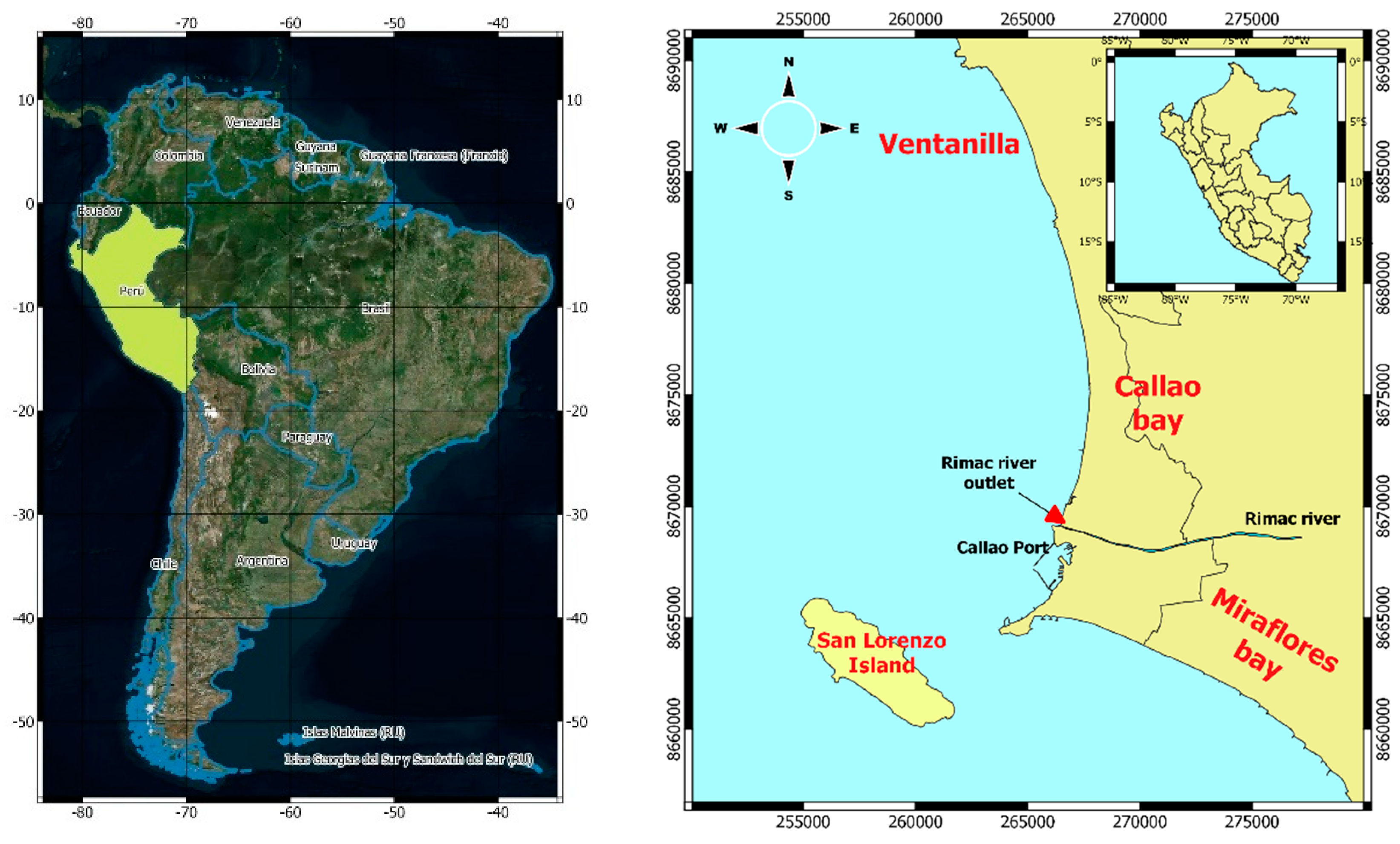
2. Case Study
3. Materials and Methods
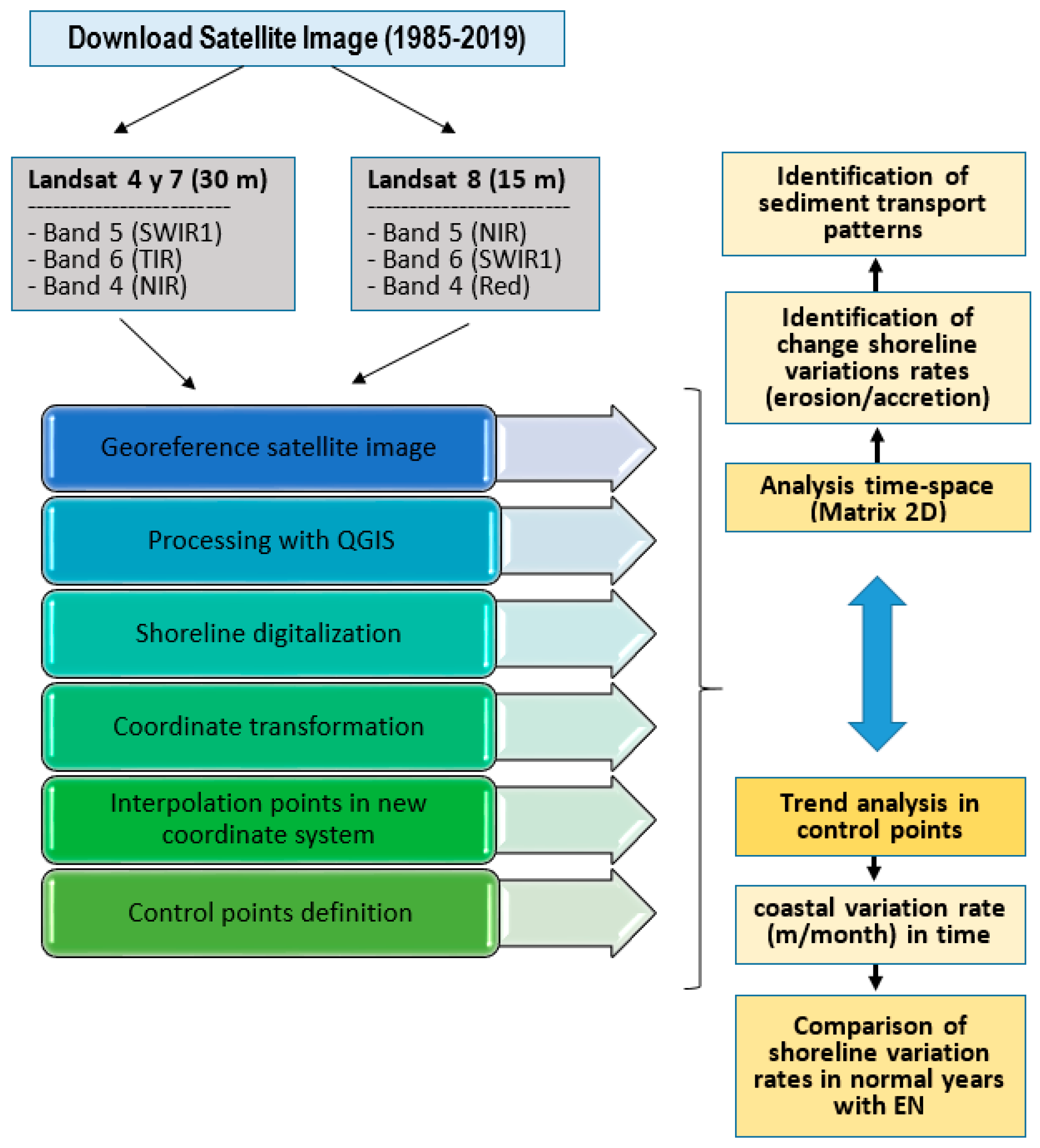
- Landsat images are downloaded from the Earth Explorer website. Images were selected from 1985 to 2019 from Landsat 4 to Landsat 8, considering cloud coverage in the study area.
- The shoreline was digitized from selected satellite images. Band combination was used to differentiate the coast from the sea.
- A new origin of coordinates (Figure 5) was defined in x = 266703 and y = 8668120 (UTM zone 18S) with a 74° rotated angle. In this step new shoreline coordinates were obtained.
- A 2D interpolation is executed along the new coordinate system to calibrate all points to the same reference level.
- Distances are calculated with respect to the previous year to determine positive and negative variations of the shoreline, and the rate of variations is measured in m/month.
- A 2D matrix in time and space is constructed to present trends. This analysis allows for the identification of coastal erosion/sedimentation zones.
- Tidal variations shown in the digitalization of coastline were neglected due to their very low range of around 0.5 m (Table 1). The maximum water level difference between the consecutive images used in the analyses was 0.2 m. Given the average beach slop of 0.01, this could lead to a maximum 20 m of inaccuracy in the horizontal position of a coastline. The maximum possible inaccuracy due to this simplification was smaller than the resolution of the images.
- Satellite images show the total variation in shoreline, including changes due to other processes of coastline variation, e.g., wave and tidal forcing as well as for sea level rise, which for Peru was 5 cm from 1942 to 2001 [26].
- Cubic spline interpolation was performed between digitalized points.
4. Results and Discussions
5. Conclusions
Author Contributions
Funding
Acknowledgments
Conflicts of Interest
References
- Ranasinghe, R.; Duong, T.M.; Uhlenbrook, S.; Roelvink, D.; Stive, M. Climate-change impact assessment for inlet interrupted coastlines. Nat. Clim. Change 2013, 3, 83–87. [Google Scholar] [CrossRef]
- Bamunawala, J.; Ranasinghe, R.; van der Spek, A.; Maskey, S.; Udo, K. Assessing Future Coastline Change in the Vicinity of Tidal Inlets. J. Coastal Res. 2018. [Google Scholar] [CrossRef]
- Thatje, S.; Heilmayer, O.; Laudien, J. Climate variability and El Niño Southern Oscillation: implications for natural coastal resources and management. Helgol. Mar. Res. 2008, S5–S14. [Google Scholar] [CrossRef] [Green Version]
- Barnard, P.; Allan, J.; Hansen, J.; Kaminsky, G.; Ruggiero, P.; Doria, A. The impact of the 2009–2010 El Niño Modoki on U.S. West Coast beaches. Geophys. Res. Lett. 2011, 38, 1–7. [Google Scholar] [CrossRef] [Green Version]
- Storlazzi, C.; Griggs, G. Influence of El Niño–Southern Oscillation (ENSO) events on the evolution of central California’s shoreline. GSA Bullet. 2000, 112, 236–249. [Google Scholar] [CrossRef]
- Barnard, P.; Hoover, D.; Hubbard, D.; Snyder, A.; Ludka, B.; Allan, J.; Kaminsky, G.; Ruggiero, P.; Gallien, T.; Gabel, L.; et al. Extreme oceanographic forcing and coastal response due to the 2015–2016 El Niño. Nat. Commun. 2017, 1–8. [Google Scholar] [CrossRef] [Green Version]
- Allan, J.; Komar, P. Extreme Storms on the Pacific Northwest Coast during the 1997–1998 El Niño and 1998–1999 La Niña. J. Coast. Res. 2002, 18, 175–193. [Google Scholar]
- Barnard, P.; Short, A.; Harley, M.; Splinter, K.; Vitousek, S.; Turner, I.; Allan, J.; Banno, M.; Bryan, K.; Doria, A.; et al. Coastal vulnerability across the Pacific dominated by El Niño/Southern Oscillation. Nat. Geosci. 2015, 8, 801–807. [Google Scholar] [CrossRef]
- Takahashi, K. The atmospheric circulation associated with extreme rainfall events in Piura, Peru, during 1997–1998 and 2002 El Niño events. Ann. Geophys. 2004, 22, 3917–3926. [Google Scholar] [CrossRef] [Green Version]
- Ramirez, I.; Briones, F. Understanding the El Niño Costero of 2017: The Definition Problem and Challenges of Climate Forecasting and Disaster Responses. Int. J. Disaster Risk Sci. 2017, 8, 489–492. [Google Scholar] [CrossRef] [Green Version]
- Rodriguez-Morata, C.; Diaz, H.F.; Ballesteros Canovas, J.A.; Rohrer, M.; Stoffel, M. The anomalous 2017 coastal El Niño event in Peru. Clim. Dyn. 2019, 52, 5605–5622. [Google Scholar] [CrossRef]
- Vera, L.; Marin, S. Clima De Olas En La Zona Ecuatorial Con Información Satelital. Acta Oceanográfica Del Pacífico 2015, 20, 45–56. [Google Scholar]
- Ramos, C.; Guzman, E.; Sarango, D.; Carbonel, C. Determinación del clima de olas en aguas profundas, frente a las costas del Perú mediante calibración de reanálisis numérico e información instrumental. Rev. Investig. Física 2017, 20, 1–18. [Google Scholar]
- CENEPRED. Estudio: Escenarios de riesgos ante la probabilidad de ocurrencia del fenómeno El Niño octubre 2012. Available online: https://sigrid.cenepred.gob.pe/sigridv3/documento/846 (accessed on 18 November 2019).
- Takahashi, K.; Martinez, A. The very Strong El Niño 1925 in the far-eastern Pacific. Clim. Dyn. 2016, 10, 7389–7415. [Google Scholar] [CrossRef] [Green Version]
- Ramos, C.; Guzman, E.; Choque, E. Estimación preliminar de la evolución morfodinámica del delta del río Rimac producto del fenómeno El Niño Costero. Bitácora Hidrográfica 2017, 17, 11–14. [Google Scholar]
- Erbert, G.L. Erofeeva, Efficient inverse modeling of barotropic ocean tides. J. Atmos. Oceanic Technol. 2002, 19, 183–204. [Google Scholar] [CrossRef] [Green Version]
- Velazco, F. Sedimentos Marinos Superficiales en la bahía del Callao- Perú 1997. Boletín Inst. Mar Perú 2011, 26, 75–82. [Google Scholar]
- Gobierno Regional del Callao, Mapa Geológico. 2011. Available online: http://sitr.regioncallao.gob.pe/catalogoMapa/02_MAPA_GEOLOGICO.pdf (accessed on 18 November 2019).
- Villacorta, S.; Evans, K.; Torres, T.; Llorente, M.; Prendes, N. Geomorphological evolution of the Rimac River’s alluvial fan, Lima, Peru. Geosci. J. 2018, 23, 1–16. [Google Scholar] [CrossRef]
- Robleto, G.; Schutze, M.; Godoy, E. Modelling and Simulation of Coupled Systems-Water and Energy—Case Study of the Water Reservoir System of the Rimac River Catchments; Studies in Computational Intelligence; Springer: Berlin/Heidelberg, Germany, 2012; pp. 159–170. [Google Scholar]
- ENFEN. Informe Técnico ENFEN, Secretaria Técnica ENFEN, Lima, Diciembre 2016, 52p. Available online: https://www.dhn.mil.pe/Archivos/oceanografia/enfen/informe-tecnico/12-2016.pdf (accessed on 8 November 2019).
- ENFEN. Informe Técnico ENFEN, Secretaria Técnica ENFEN, Lima, Diciembre 2017, 54p. Available online: https://www.dhn.mil.pe/Archivos/oceanografia/enfen/informe-tecnico/12-2017.pdf (accessed on 19 September 2019).
- Morera, S.B.; Condom, T.; Crave, A.; Steer, P.; Guyot, J.L. The impact of extreme El Niño events on modern sediment transport along the western Peruvian Andes (1968–2012). Sci. Rep. 2017, 7, 1–14. [Google Scholar] [CrossRef] [Green Version]
- USGS. EarthExplorer—Home. Available online: https://earthexplorer.usgs.gov/ (accessed on 13 September 2019).
- Quispe, J. Sea level variation in Callao (12°S) Peru 1942–2001. Investig. Mar. 2002, 30, 101–102. [Google Scholar] [CrossRef]
- Davies, J.L. A morphogenic approach to world shorelines. Z. Geomorphol. 1984, 8, 27–42. [Google Scholar]
- Hayes, M.O. Wave-Dominated Coasts. In Encyclopedia of Coastal Science. Encyclopedia of Earth Science Series; Schwartz, M.L., Ed.; Springer: Dordrech, The Netherlands, 2005. [Google Scholar]
- Cluis, D.; Laberge, C. Analysis of the El Niño Effect on the Discharge of Selected Rivers in the Asia-Pacific Region. Water Int. 2002, 27, 279–293. [Google Scholar] [CrossRef]
- Wards, P.; Beets, W.; Bouwer, L.; Aerts, J.; Renssen, H. Sensitivity of river discharge to ENSO. Geophys. Res. Lett. 2010, 37. [Google Scholar] [CrossRef] [Green Version]


| Name | Amplitude (m) | Phase (°) |
|---|---|---|
| M2 | 0.22 | 314.8 |
| S2 | 0.08 | 323.5 |
| N2 | 0.06 | 282.2 |
| K2 | 0.03 | 331.0 |
| K1 | 0.14 | 28.3 |
| O1 | 0.07 | 347.9 |
| Year | Month | Day | Year | Month | Day | Year | Month | Day |
|---|---|---|---|---|---|---|---|---|
| 1985 | 1 | 10 | 1996 | 4 | 14 | 2007 | 3 | 28 |
| 1986 | 5 | 5 | 1997 | 2 | 3 | 2008 | 3 | 21 |
| 1987 | 3 | 5 | 1997 | 12 | 13 | 2009 | 4 | 2 |
| 1987 | 12 | 18 | 1998 | 5 | 6 | 2010 | 10 | 30 |
| 1988 | 3 | 23 | 1998 | 12 | 16 | 2011 | 3 | 11 |
| 1988 | 4 | 8 | 1999 | 2 | 18 | 2015 | 5 | 5 |
| 1988 | 11 | 2 | 1999 | 6 | 26 | 2016 | 3 | 4 |
| 1989 | 12 | 23 | 1999 | 12 | 3 | 2016 | 12 | 17 |
| 1990 | 1 | 8 | 2000 | 12 | 5 | 2017 | 2 | 19 |
| 1991 | 2 | 28 | 2002 | 3 | 13 | 2017 | 4 | 15 |
| 1991 | 12 | 13 | 2002 | 5 | 9 | 2018 | 1 | 21 |
| 1993 | 2 | 17 | 2003 | 4 | 1 | 2018 | 4 | 18 |
| 1993 | 9 | 20 | 2004 | 1 | 31 | 2019 | 2 | 16 |
| 1993 | 10 | 7 | 2004 | 12 | 7 | |||
| 1995 | 5 | 14 | 2006 | 4 | 26 |
| Point | Coordinates (UTM 18S) | Distance from New Origin Coordinates (m) | Location | |
|---|---|---|---|---|
| X | Y | |||
| P01 | 266981.0 | 8669064.0 | 1000 | Rimac river |
| P02 | 267311.0 | 8670021.0 | 2000 | Acapulco beach |
| P03 | 267640.0 | 8670970.0 | 3000 | Fertiza beach |
| P04 | 268568.0 | 8673880.0 | 6000 | Oquendo beach |
| Loc. | Slope (m/month/m) | Conclusion |
|---|---|---|
| P01 | 0.275 | Accretion |
| P02 | 0.209 | Accretion |
| P03 | 0.067 | Accretion |
| P04 | 0.150 | Accretion |
| Loc. | Period | |||||||||||||
|---|---|---|---|---|---|---|---|---|---|---|---|---|---|---|
| 1985–1990 | 1990–1995 | 1995–2000 | 2000–2005 | 2005–2010 | 2010–2015 | 2015–2019 | ||||||||
| Normal | Niño | Normal | Niño | Normal | Niño | Normal | Niño | Normal | Niño | Normal | Niño | Normal | Niño | |
| P01 | −13.69 | −14.01 | 4.63 | 17.89 | 2.94 | 29.44 | −9.19 | −5.33 | −1.29 | 0.43 | 5.91 | 7.06 | −0.91 | 2.61 |
| P02 | −4.66 | −8.6 | 0.01 | 0.8 | 1.12 | 2.226 | 0.8 | −1.12 | −0.77 | 0.07 | 2.76 | 3.73 | 3.06 | 5.50 |
| P03 | 0.02 | 1.2 | 1.47 | 1.31 | 2.55 | 3.75 | 1.65 | −1.34 | −0.69 | 1.28 | 2.76 | 3.12 | 3.10 | 3.75 |
| P04 | −1.91 | 2.84 | 1.49 | −0.01 | 0.41 | 0.14 | 0.73 | −2.94 | 1.10 | −2.96 | 5.39 | 3.98 | 1.93 | 0.01 |
© 2020 by the authors. Licensee MDPI, Basel, Switzerland. This article is an open access article distributed under the terms and conditions of the Creative Commons Attribution (CC BY) license (http://creativecommons.org/licenses/by/4.0/).
Share and Cite
Guzman, E.; Ramos, C.; Dastgheib, A. Influence of the El Niño Phenomenon on Shoreline Evolution. Case Study: Callao Bay, Perú. J. Mar. Sci. Eng. 2020, 8, 90. https://doi.org/10.3390/jmse8020090
Guzman E, Ramos C, Dastgheib A. Influence of the El Niño Phenomenon on Shoreline Evolution. Case Study: Callao Bay, Perú. Journal of Marine Science and Engineering. 2020; 8(2):90. https://doi.org/10.3390/jmse8020090
Chicago/Turabian StyleGuzman, Emanuel, Carmela Ramos, and Ali Dastgheib. 2020. "Influence of the El Niño Phenomenon on Shoreline Evolution. Case Study: Callao Bay, Perú" Journal of Marine Science and Engineering 8, no. 2: 90. https://doi.org/10.3390/jmse8020090
APA StyleGuzman, E., Ramos, C., & Dastgheib, A. (2020). Influence of the El Niño Phenomenon on Shoreline Evolution. Case Study: Callao Bay, Perú. Journal of Marine Science and Engineering, 8(2), 90. https://doi.org/10.3390/jmse8020090