Review

The Tidal Stream Energy Resource of the Fromveur Strait—A Review

by
Nicolas Guillou
1,*,
Jean-Frédéric Charpentier
2 and
Mohamed Benbouzid
3
1
Laboratoire de Génie Côtier et Environnement (LGCE), Direction Eau Mer et Fleuves, Département Environnement et Risques, Cerema, 155 rue Pierre Bouguer Technopôle Brest-Iroise, BP 5, 29280 Plouzané, France
2
French Naval Academy, EA 3634 IRENav, 29240 Brest, France
3
Institut de Recherche Dupuy de Lôme (UMR CNRS 6027), University of Brest, 29238 Brest, France
*
Author to whom correspondence should be addressed.
J. Mar. Sci. Eng. 2020, 8(12), 1037; https://doi.org/10.3390/jmse8121037
Submission received: 27 November 2020 / Revised: 14 December 2020 / Accepted: 15 December 2020 / Published: 19 December 2020
(This article belongs to the Special Issue Offshore and Onshore Marine Renewable Energy)

Abstract

:
Refined assessments of the available tidal stream energy resource are required to optimize turbines design and guarantee successful implementations and operations of devices in the marine environment. Investigations primary focused on identifying areas with maximum current speeds. However, further information may be reached by exhibiting (i) resource temporal variability, (ii) superimposed effects of meteo-oceanographic conditions (including especially wind-generated surface-gravity waves), and (iii) potential environmental impacts of operating turbines at the regional (e.g., changes in sediment transport and surrounding seabed features, effects on marine water quality, etc.) and local (wake-wake interactions and energy output) scales. These aspects are here investigated by reviewing a series of research studies dedicated to the Fromveur Strait off western Brittany, a region with strong potential for tidal array development along the coast of France. Particular attention is dedicated to the exploitation of combined in-situ and remote-sensing observations and numerical simulations. Beyond a site specific characterization of the tidal stream energy resource, this review promotes a series of original approaches and analysis methods for turbines optimization, thus complementing technical specifications to secure the key steps of a tidal energy project and promote the growth of a reliable tidal stream energy exploitation.

1. Introduction

In recent decades, the exploitation of the kinetic energy of tidal currents has attracted the interest of many governments that committed to reduce carbon dioxide emissions for limiting the impacts of Climate Change and global warming. Many advantages were therefore put forward to promote the development of this energy sector, among which (i) the highly predictable characteristics of the resource and (ii) the reduced visual impacts of energy converters which enables an easier acceptance by coastal users and communities. However, in comparison with other types of renewable resources (including especially wind and solar energy), the exploitation of tidal stream energy still shows important economic uncertainty. The major reasons are (i) the weak lifespan and high construction and maintenance costs of devices which have to withstand harsh environmental conditions (hydrodynamic load, saltwater corrosive effects and biofouling, etc.) and are, most of the time, anchored to the bottom, (ii) the reduced efficiency in converting the available resource into electricity and (iii) the small number of potential locations for energy exploitation restricted to estuaries and shallow-water straits. These different issues have lead to the failure of numerous tidal power projects, recently exhibited by the liquidations of the pioneer OpenHydro company with a series of leading demonstrators in the Minas Basin (eastern Canada), northern Brittany (France) and the English Channel [1].
However, whereas a massive exploitation of the tidal stream energy resource appears today difficult to achieve, this energy sector still shows promising potential in island territories unconnected to the continental electricity grid. Indeed, in these areas, the electricity production relies, most of the time, on expensive and polluting fuel power stations whereas strong tidal currents and associated renewable kinetic energy resource may develop in the strait separating the island from the landmass. The local exploitation of this tidal stream energy resource may therefore provide a part of renewable power within the grid while complementing other forms of renewable resources (such as wind or wave energy) and leading to the energetic autonomy of these off-grid communities [2]. This is why island territories are key environments for the development of tidal power projects and the emergence of next generation disruptive technologies that would be economically viable for a massive exploitation of the resource. Significant commercial and research interests were thus dedicated to tidal straits located in the vicinity of islands. In the European shelf seas where numerous technological devices were developed, particular attention was brought to the marine areas around the United Kingdom (UK) and northern France characterized by significant tidal regimes and coastal irregularities liable to induce strong tidal currents [3]. A series of full-scale devices were deployed and tested in potential tidal stream energy sites of north-western Europe, including, among others, (i) the Pentland Firth (North Scotland, UK) with the implementation of four 1.5-MW horizontal-axis turbines grid connected (MeyGen Project) [4], (ii) the Fall of Warness (Orkney archipelago, North Scotland, UK) with the implementation of a 1-MW device (European Marine Energy Centre—EMEC) [5], and (iii) the Fromveur Strait (western Brittany, France) with the setup of a horizontal-axis turbine (Sabella demonstrator device) [6]. The European Tidal Industry is furthermore experimenting promising next generation technologies contrasting with traditional bottom-anchored horizontal-axis turbines and liable to give new impetus to the tidal energy sector. This includes (i) the 1-MW vertical-axis HydroQuest device currently tested in the experimental site of Paimpol-Bréhat (northern Brittany, France) [7] and (ii) the 2-MW floating Orbital Marine turbine implemented in the EMEC site (Orkney archipelago, North Scotland, UK) [8].
Successful deployment of tidal-kinetic energy converters in the marine environment require, however, detailed assessments of (i) the available resource, (ii) the potential environmental impact of operating turbines, and (iii) the technical generated power, this in order to optimize the design, performances, and locations of devices but also the layout and configuration of the tidal farm. Resource assessments have, in particular, to go beyond the simple identification of areas with the highest current magnitudes by integrating further physical characteristics of the marine environment. Indeed, the available resource may be characterized by a high spatial and temporal variability, being liable to change (i) over small spatial scales (between the entrance and the center part of a tidal strait) but also over (ii) tidal-to-decadal time scales. Particular attention must therefore be dedicated to resource temporal variability that may impact devices performances but also exhibit problems for incorporating the unsteady generated power into local grids, primary adapted to a consistent power supply [9,10]. Superimposed effects of meteorological and oceanographic conditions may furthermore be considered. This concerns especially the potential impacts of wind and wind-generated surface-gravity waves that may alter tidal currents and associated power density [11]. As tidal stream energy sites (and especially tidal straits) constitute a significant pathway for the transport of water in coastal marine systems, further investigations have to be conducted for evaluating the potential system-wide changes (hydrodynamic circulation and water-particles displacement) induced by tidal-stream energy extraction [12]. Refined assessments of the generated technical power, including the approach of turbine wake interactions and turbines hybridization options with other renewable resources, are finally fundamental to design the tidal farm with respect to local energy needs.
Following these objectives, we proposed here a review of the different resource assessments and environmental studies applied to a tidal stream energy site in the preliminary stages of devices design and testing in the marine environment. The application was dedicated to the Fromveur Strait, a region with strong potential for tidal array development along the coast of France (Figure 1 and Figure 2).
This location is a typical tidal strait of coastal shelf seas that separates, off western Brittany in the Sea of Iroise, the island of Ushant from a series of islets and rocks surrounding the island of Molène, and thereby entitled the Molène archipelago. Considered as the second largest tidal stream energy resource along the coast of France (after the Alderney Race in the English Channel), the French government identified a restricted area of 4 k m 2 within the strait for the development of tidal farm projects. The company Sabella SAS is currently conducting the optimization process of a horizontal-axis turbine, entitled Sabella D10, within this environment. This is one of the few French marine locations (outside of estuaries and rivers) where the kinetic energy of tidal currents is exploited to supply electricity to the grid (thus supplying a part of renewable energy to the local Ushant grid). Thus, the present review may foster the implementation of a tidal farm within this environment by providing further insights about resource characteristics and potential environmental effects of large-scale energy exploitation. Beyond this site-specific interest, this review may, however, complement technical specifications and promote new methods of analysis to secure the key steps of a tidal energy project while limiting the risks for potential investors. Such review is therefore a contribution to the growth of a reliable exploitation of tidal stream energy in islands environments, thus attracting increased subsidies and investments while guaranteeing the capital investment and economical return.
The paper is organized as follows. Section 2 reviews the different observations and numerical simulations implemented in the Fromveur Strait for advanced resource characterization. After an overall description of the general bathymetric and hydrodynamic features of the strait (Section 3), particular attention is dedicated to energy resource assessments (Section 4), exhibiting (i) temporal variability at semidiurnal and fortnightly time scales (Section 4.1) and (ii) potential superimposed effects of waves (Section 4.2). These results are fundamental to refine the location and design of energy converters within the strait. We finally review the investigations dedicated to tidal stream energy extraction (Section 5) focusing on (i) regional environmental effects (Section 5.1) and (ii) local sizing and optimization studies at the scale of the tidal turbine array (Section 5.2).

2. Materials and Methods

A refined assessment of the tidal stream energy resource requires the access to a series of available data encompassing observations (in situ and/or remote sensing) but also numerical hindcast databases and reanalysis archives or more advanced numerical simulations specifically dedicated to resource characterization. We review here the different data and approaches considered to assess the available and technically exploitable resources of the Fromveur Strait.

2.1. Observations

The 4 k m 2 area retained for tidal stream energy exploitation was the subject of refined investigations dedicated to assess the environmental and physical characteristics of the Fromveur Strait. The French Naval Oceanographic Centre SHOM (“Service Hydrographique et Océanographique de la Marine”) established thus a high-resolution bathymetry of the area of interest (at a spatial resolution of 1.5 m) with a detailed cartography of the seabed characteristics which complemented sedimentological maps at the regional scale of western Brittany [13]. Observations of hydrodynamic conditions were also conducted. However, such data may be subjected to restriction and commercial license, and thus a limited number of tidal observations are available in the Fromveur Strait. Resource assessments in this environment exploited mainly in-situ current observations acquired between 1993 and 2012 by the SHOM (Table 1, Figure 1). These measurements were conducted with (Acoustic Doppler Current Profile (ADCP) in a series of neap-spring tidal conditions. ADCP data, distributed in 2 m bins throughout the water column, were thus available in the center part of the area identified for turbines implementation (Figure 2). Complementing in-situ current measurement, High Frequency Radar (HFR) Observations of surface currents were implemented by the SHOM to get further insights about physical processes governing the surface circulation in the north-eastern part of western Brittany [14]. The instrumentation system was composed of two high-frequency Wellen Radars (WERA) operating at 12.4 MHz and was deployed in July 2006. These remote-sensing observations were too coarse to capture the structure of the tidal circulation in the vicinity of islands and shoals of Ushant-Molène archipelago. However, Sentchev et al. [15] reprocessed these data, thus reaching refined mapping of surface currents with a time step of 20 min and a spatial resolution of 1 km. The resulted high-resolution cartography revealed fine-scales structures of the surface circulation in and around the strait and provided a reference synoptic database to investigate the variability of surface tidal currents. There exists furthermore complementary in-situ observations of hydrodynamic parameters including the energy spectrum of wind-generated surface gravity waves (over frequencies and directions) and associated bulk parameters (such as the significant wave height, peak direction, or mean wave direction). The area of interest integrates thus two directional wave buoys located (i) South of Molène and (ii) in the eastern part of the Fromveur Strait (Table 1, Figure 1 and Figure 2).

2.2. Predictions

Observations are not always available in locations retained for tidal stream energy extraction and in the vicinity of devices currently implemented in the marine environment. For these reasons, the assessment of tidal hydrodynamics and associated kinetic energy of the Fromveur Strait relied on a series of analytical and numerical approaches listed in Table 2. The SHOM [13] implemented a three-dimensional simulation of the tidal circulation, based on Telemac 3D [16], in the Ushant-Molène archipelago, thus providing a high-resolution cartography of horizontal velocities in neap and spring tides at four positions throughout the water column: near the surface and the bed, at mid-height, and at 10 m above the bed matching the operating height of turbines in the strait. El Tawil et al. [17] exploited this database to (i) recompose time series of tidal velocity based on tidal range evolution, (ii) characterize the available resource, and (iii) determine the optimal location for turbines with fixed horizontal-axis or a yaw. Such a simple method appears very promising in the first steps of a tidal farm project providing a very fast evaluation of the available resource [18,19]. More advanced resource characterization was, however, reached by exploiting regional tidal current harmonic databases derived from high resolution numerical simulations. Guillou et al. [10] exploited thus the 250-m resolution tidal database derived from the depth-averaged circulation model MARS [20,21] to assess resource spatial and temporal variability in Ushant-Molène archipelago.
However, the detailed characterization of the available resource requires advanced numerical simulations that can be adapted to specific sensitivity studies (e.g., seabed roughness parameterisation), the variability of hydrodynamic and metocean conditions (including tide, wind and waves), or a series of energy extraction scenarios (e.g., devices rated power, array layout, etc.). In the Ushant-Molène archipelago and the Fromveur Strait, these advanced resource assessments were primary conducted by relying on the bidimensional horizontal (2DH) model Telemac 2D [16]. Indeed, this simulation tool relies on an unstructured mesh liable to capture the complex coastline geometry of isles and islets, thus reaching a refined spatial resolution in the strait while sparing a prohibitive number of computational nodes at the regional scale. It includes furthermore advanced wetting-drying algorithms, particularly suited to intertidal areas around Molène archipelago. Guillou and Thiébot [22,26] implemented a first version of the model in western Brittany, thus reaching a spatial resolution of 50 m in the Fromveur Strait. Particular attention was dedicated to the parameterisation of bottom roughness which was determined from the spatial distribution of sediment bottom types. Simulations were driven by tidal sea surface elevations and currents recomposed from major harmonic constituents of the TPXO7.2 database [27]. Advanced numerical resource assessment was conducted by integrating the superimposed effects of wind (surface shear stresses) and waves (radiation stresses and increased bottom friction) in Telemac 3D [23]. Particular attention was devoted to the coupling between the 3D tidal circulation and phase-averaged wave models.
Beyond refined assessments of the available resource, different numerical evaluations of the large-scale environmental effects of tidal stream energy extraction in the strait were conducted. These regional investigations relied on the distributed drag method (also denominated the continuous drag method) that consisted in parameterising the bed friction over the area covered by the tidal array as a function of turbines’ thrust and structural drag forces [22,26]. The attention was dedicated to changes in tidal current magnitudes and associated bottom shear stresses but also to the ecological robustness of this marine area. High-spatial resolution simulations were thus exploited to characterize the tide-induced Lagrangian Residual Circulation (LRC) and evaluate changes induced by operating turbines [24,28]. Additional simulations focused on the renewal capacity of Ushant-Molène archipelago [12]. The hydrodynamic model was thus coupled with a transport advection-diffusion equation to simulate the decay of a tracer concentration within a control domain surrounding the Fromveur Strait. More recently, a refined simulation of 3D turbine wake interactions was conducted at the scale of a tidal farm in the strait to refine the evaluation of the technically exploitable generated power. The investigation relied on a high-resolution configuration of the Regional Ocean Modeling System (ROMS) [29] modified to account for effects of individual turbines on the flow. Michelet et al. [25] reached therefore a simulation of these interactions with a spatial resolution of 1 m by adopting a nested grid technique and cascading processes from the regional scale to the high-resolution local farm domain.
Further details about these numerical configurations and associated modeling tools may naturally be found in the references cited. Results from these different investigations will furthermore be described, compared, and discussed in the next Section 3, Section 4 and Section 5.

3. General Features

3.1. Bathymetry and Seabed Composition

The Fromveur Strait is characterized by a width of 2 km and a mean water depth of 50 m (Figure 1 and Figure 2). Whereas water depths of the shelf remains over 80 m, the Molène archipelago exhibits large intertidal areas around the island and surrounding shoals and islets. The area of interest is furthermore characterized by two prominent seabed features on both sides of the strait: (i) the sandbank of the Four in the north and (ii) the sandbank of Ushant in the south (Figure 2 and Figure 3).
The detailed cartography established by the SHOM over the 4 k m 2 area retained for turbines implementation revealed large areas with reduced spatial variations of the bathymetry in the northern and south-eastern parts of the strait desirable for the setup of devices on the floor (Figure 2). At the scale of the archipelago, the seabed exhibits furthermore a highly heterogeneous spatial distribution of bottom sediments with (i) rocky substrates in shallow waters and in the northern part of the strait, (ii) gravel and/or sand/gravel deposits in deep waters, and (iii) localized sand supplies in surrounding seabed features (typically prominent sandbanks) (Figure 3). The detailed cartography of bed sediments established by the SHOM complemented this large-scale distribution, thus confirming (i) the presence of rocks in the center part of the Fromveur Strait and (ii) pebbles in its north-eastern and south-western parts with (iii) a negligible contribution of fine sediments.

3.2. Tidal Hydrodynamics

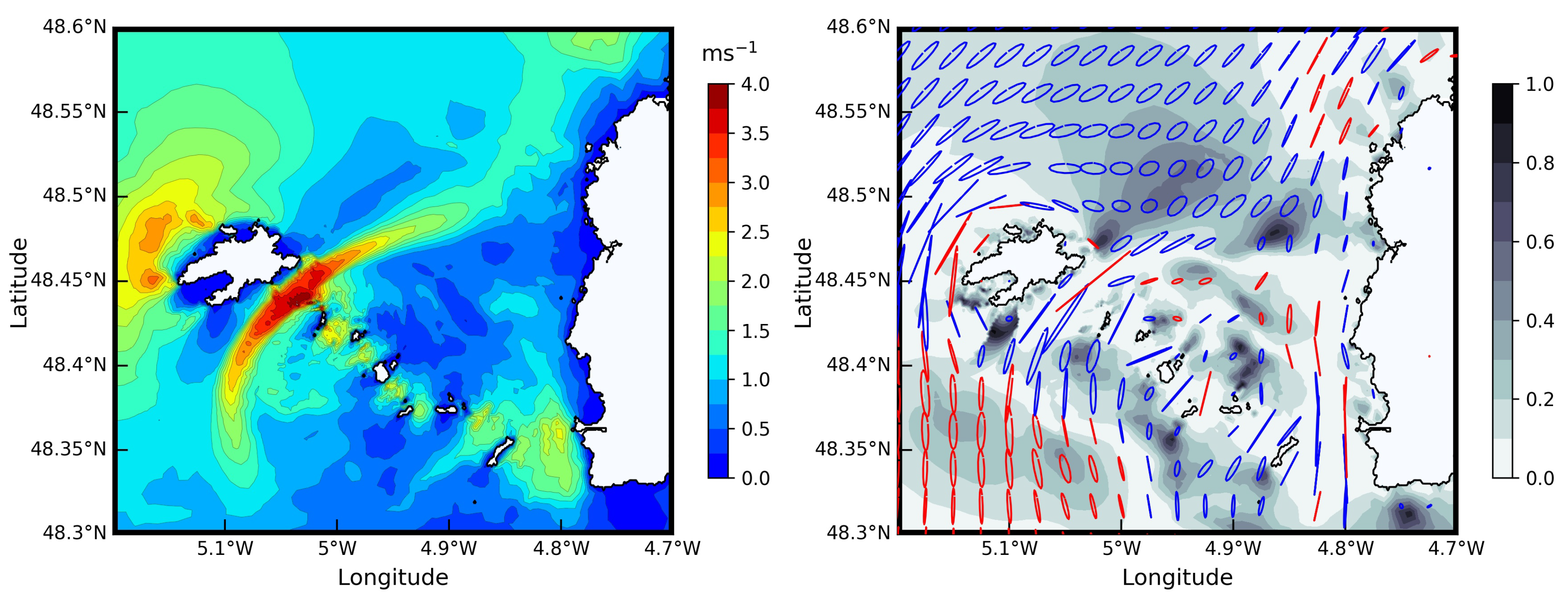
In the area of interest, tide is characterized by semidiurnal regimes with tidal range exceeding 7 m in spring conditions. Tide propagates from the Gulf of Biscay in the South towards the English Channel in the North traveling around western Brittany. Tide-induced free-surface elevations exhibit therefore noticeable time lags (≃1 h) between the southern and northern parts of the Sea of Iroise. However, reduced differences are obtained between the southern and northern approaches of the strait, thus being restricted to 5 ° for the principal lunar harmonic component M 2 [3]. In the north-eastern part of the Sea of Iroise, bathymetry gradients and the presence of rocks and islands induce strong tidal flow acceleration resulting in peak currents magnitudes west of Ushant and in the Fromveur Strait (Figure 4). In spring tidal conditions, tidal current magnitude may thus exceed 3.8 m s 1 in the strait.
Nevertheless, the region with high current magnitude exhibits reduced footprints in comparison with other tidal-stream energy sites. Indeed, the area targeted for first-generation technologies (designed to harness peak spring currents over 2.5 m s 1 in mean water depth over 25 m) occupies 16 k m 2 within the Fromveur Strait whereas it reaches 162 k m 2 in the Alderney Race (English Channel) [3]. The exploitation of available observations (Section 2.1) provided finally further insights about the characteristics of tidal currents in strait. Thus, HFR observations revealed that surface currents were exceeding (i) 1 m s 1 for around 60 % of the year and (ii) 2 m s 1 for more than 20 % of the year [31]. The exploitation of in-situ measurements showed furthermore that, at peak ebb and flood, vertical velocity profiles within the strait tended to follow a power law of the form V ( z ) = V 0 ( z / d ) 1 / α with V 0 the surface current magnitude, z the vertical level and d the water depth, the best fit being obtained for a power coefficient α = 5.8 [31].
As exhibited by current ellipses of the dominant M 2 component, the flow in the strait appears nearly rectilinear, thus confirming the interest of this area for the setup of fixed-orientation devices (Figure 4). However, the evolution of tidal currents remains a complex process under the influence of interactions between harmonic components exhibited in shallow waters. Thus, fortnightly velocity modulations were impacted by nonlinear interactions between principal and shallow-water constituents ( M 6 , 2 M S 6 and 2 S M 6 ) which were themselves amplified in the strait [15]. Asymmetry of tidal currents between peak ebb and flood were also related to nonlinear interactions between M 2 and its first quarter-diurnal harmonic M 4 [24,32]. The Fromveur Strait is thus characterized by (i) a north-eastern region with flood-dominated flows and (ii) a south-western area experiencing ebb-dominated flows [22]. These two areas are separated by a central divergence with reduced semidiurnal asymmetry in tidal currents magnitude. The region is furthermore characterized by clockwise rotating currents following the spatial pattern of the sea surface gradients as a result of tidal wave propagation around western Brittany, and this effect is reinforced by the Coriolis force [15]. However, counter-clockwise currents were identified in the south-western part of the archipelago and west of Ushant [3,31]. Sentchev et al. [15] suggested that this positive polarization of current ellipses may be associated to (i) the effect of bottom friction in shallow waters and (ii) vorticity production in larger water depths. Significant vorticity was thus produced on the south-western and north-eastern parts of the Fromveur Strait impacting the rotation of tidal currents in these areas [24]. Whereas tidal currents in the central strait appear nearly rectilinear, these different processes influence the asymmetry in tidal current direction in the south-western and northern extremities of the strait, mainly in the vicinity of shoals and the coastline [25].

3.3. Meteo-Oceanographic Conditions

Meteorological and oceanographic conditions constitute fundamental datasets for (i) refining the assessment of the tidal stream energy resource, (ii) adapting the design of turbines to environmental conditions, and (iii) securing operation maintenance. We review here the principal metocean conditions encountered in the north-western part of the Sea of Iroise by focusing on the potential modulations on the available tidal stream energy resource. This includes especially a review of sea surface temperature, wind and waves regimes.
Thus, the offshore extend of western Brittany experiences, in spring and summer, strong thermal stratification with the generation of offshore and nearshore fronts, among which the well-known Ushant front that appears west of Ushant and separates tidally mixed coastal waters from thermally stratified offshore waters [33,34]. While the influence of salinity gradients associated with river outflows in the bay of Brest appears limited in the Sea of Iroise, temperature gradients may induce density stratification effects in the nearshore region impacting current dynamics in western Brittany [35]. However, minimal effects are expected within the Fromveur Strait where the intense tide-induced hydrodynamics results in a well-mixed water column with weak variations of the temperature between the sea surface and the seabed.
The region is furthermore exposed to strong meteorological conditions with wind speed liable to reach 50–60 m s 1 during winter storms. By exploiting remotely sensed data retrieved from ASCAT and QuickSCAT scatterometers, Bentamy and Croize-Fillon [36] provided further insights about wind conditions off western Brittany. Associated to the atmospheric circulation patterns over the Northeast Atlantic Ocean, wind conditions in western Brittany show strong seasonal variability, characterized by winter speeds 50 % higher than summer speeds. The mean wind speed values are thus estimated at 9.9 m s 1 in winter against 5.5 m s 1 in summer. The spatial distribution of wind speed magnitudes exhibits furthermore a noticeable gradient. Indeed, winds appear higher off the northern coast of western Brittany in relation to the “bottleneck” effect of the English Channel. The wind direction shows finally some specificities. Offshore highest winds are mainly directed towards the east and appear during winter storms. However, these energetic conditions account for a reduced proportion of events, being estimated below 0.5 % for winds higher than 20 m s 1 . Thus, increased variability in the wind direction is exhibited for low winds (below 5 m s 1 ) around easterly and westerly distributions.
Varying on similar time scales to that of the weather climate, a strong correlation is exhibited between wind and wave conditions. Whereas oceanic waves experience significant energy decrease over the north-western European continental shelf (predominantly associated with bottom friction), the offshore extend of the Brittany Peninsula is one of the most energetic region along the coast of France characterized by significant wave height H s liable to exceed 10 m [37]. In the Sea of Iroise, wind-generated surface gravity waves originate mainly from the western direction with H s values in the range 1–3 m [23]. This distribution is, however, liable to vary with respect to seasonal and annual variability of wave conditions and the processes of generation, dissipation and nonlinear wave-wave interactions impacting wave propagation from offshore opened ocean to shallow waters [38,39]. A clear contrast is therefore exhibited between (i) the winter energetic months characterized by strong interannual variability and (ii) the summer low-energetic periods characterized by reduced variability. A noticeable consequence is that the most energetic month during the winter period may change with respect to the year considered. Despite the shelter provided by the island of Ushant, the Fromveur Strait is furthermore subjected to energetic waves with significant wave height liable to exceed 3.5 m in storm conditions [40]. Moreover, the north-western part of the Sea of Iroise is characterized by important wave and current interactions. Current-induced refraction is thus leading to semidiurnal modulations of H s reaching nearly 30 % in mean water depth of 60 m. The Fromveur Strait experiences also localized steepening and waves breaking on negative current gradients that influence wave conditions over the area targeted for the setup of tidal turbines.

4. Resource Assessments

As exhibited in Section 2.1 and Section 2.2, a series of investigations based on observations and numerical simulations were implemented in the Ushant-Molène archipelago to refine the assessment of the available tidal stream energy resource. Thus, Thiébaut and Sentchev [31] combined (i) remotely sensed HFR observations of surface velocities with (ii) in-situ ADCP measurements of velocity profiles to characterize the hydrokinetic resource around the island of Ushant. Complementing the stand-alone exploitation of current observations, Guillou and Thiébot [22] implemented a high-resolution numerical simulation of the tidal circulation in the north-western part of the Sea of Iroise, thus providing a detailed assessment of resource spatiotemporal variability. Different approaches were furthermore adopted by (i) exploiting numerical hindcast databases with a series of specific energy metrics or (ii) introducing the superimposed effects of metocean conditions, in particular wind-generated surface-gravity waves. We review here these different investigations by exhibiting the main contributions and outputs for refining the spatial and temporal characteristics of the available resource.

4.1. Tide-Induced Variability

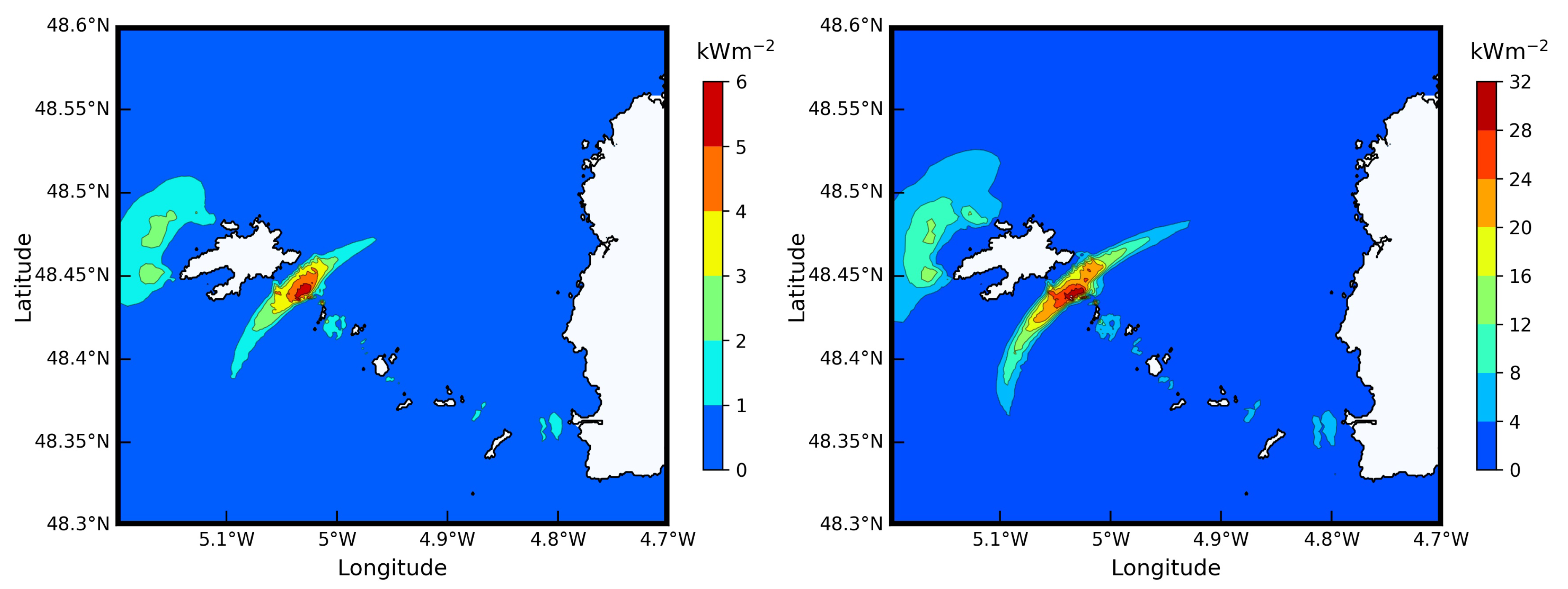
In the Fromveur Strait, numerical simulations estimated that the mean and maximum tidal kinetic power densities were reaching values over 5 and 25 k W m 2 , respectively [23]. Such averaged and maximum estimates were exploited to identify potential sites for tidal stream energy exploitation within the strait. To refine the selection of areas for the setup of turbines, the Carbon Trust [41] recommends to retain locations where the power density, averaged over a spring-neap tidal cycle, exceeds 2.5 k W m 2 . Following this criteria, the area extend for tidal stream energy extraction within the Fromveur Strait was estimated at 7 k m 2 [3]. This criteria halves nearly the area extend of 16 k m 2 initially estimated with peak spring currents magnitudes (with values over 2.5 m s 1 , Section 3.2), but remains consistent with the surface of 4 k m 2 targeted for turbines implementation in the strait. The spatial distribution of the available power density is furthermore characterized by a lateral gradient with (i) increased values in the south-eastern region and (ii) reduced values in the north-western area of the Fromveur Strait (Figure 5). Such distribution resulted mainly from the impacts of the bathymetry and islands geometry on the tidal circulation in Ushant-Molène archipelago, the area with the highest power density matching the shallow waters around the northern part of Molène archipelago. However, bulk estimates of the averaged and maximum values provide limited information about the temporal variations of available power which is a prerequesite to optimize the location and design of kinetic energy converters. Further insights may thus be reached by investigating resource temporal variability over semidiurnal and fortnightly time scales.

4.1.1. Tidal Asymmetry

As exhibited in the description of tidal hydrodynamic features (Section 3.2), the Fromveur Strait is characterized by prominent tidal currents asymmetry between peak ebb and flood, and these semidiurnal inequalities may impact the output practical power. Guillou et al. [10] exhibited these effects by exploiting a high-resolution tidal current harmonic database and evaluating the expected technical power from a 1.5 MW rated horizontal-axis turbine based on the OpenHydro device. This investigation revealed variations of up 1.0 MW in the south-western area (experiencing ebb-dominated flows) whereas it was restricted to 0.5 MW in the central divergence area (with reduced asymmetry). Semidiurnal inequalities appear typically between neap and spring conditions, when the current speed remains below the design speed (and thus a technical power below the rated power). Weak differences are therefore obtained in spring conditions between the areas with low and high tidal asymmetry. However, temporal variations over semidiurnal time scale impact the energy production over fortnightly time scale, thus reducing turbines performances. The power generated during a mean spring-neap tidal cycle, by the 1.5-MW turbine, appeared thus 12 % lower in the location with high semidiurnal asymmetry (213 MWh) than in the central divergence area (242 MWh).
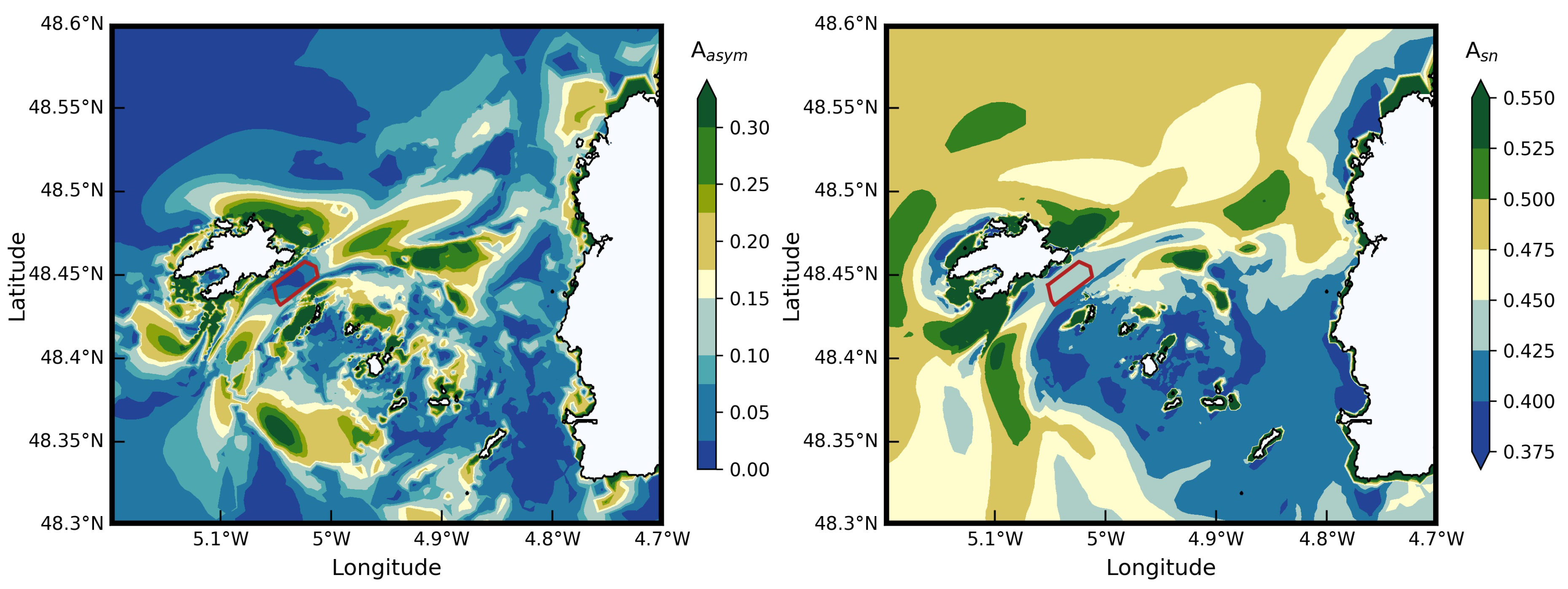
Particular attention was therefore dedicated to refine the cartography of areas with reduced and pronounced tidal current asymmetry between peak ebb and flood. As exhibited by Pingree and Griffiths [42] and Friedrichs and Aubrey [43], this semidiurnal asymmetry may arise from the phase relationship between M 2 and M 4 tidal current harmonic components by following the relationship β = 2 ϕ M 2 ϕ M 4 with ϕ M 2 and ϕ M 4 the phases of both tidal current constituents. Symmetry is reached when M 2 and M 4 are out of phase ( β = 90 / 270 ° ) whereas maximum asymmetry is obtained when both components are in phase ( β = 0 / 180 ° ). In the Fromveur Strait, this relationship between tidal current asymmetry and phase lags of harmonic components was successively ascertained by exploiting HFR surface velocity observations [32] and numerical simulations of the tidal circulation [24]. On the basis of this relationship, Guillou et al. [10] characterized the tidal current asymmetry by relying on the resource metric
A a s y m = u ¯ m a x ( M 4 ) u ¯ m a x ( M 2 ) | cos β |
defined as the ratio between the maximum magnitudes of depth-averaged currents resulting from M 2 and M 4 , u ¯ m a x ( M 4 ) and u ¯ m a x ( M 2 ) . Tidal asymmetry was therefore exhibited by high values of A a s y m while more symmetrical current magnitudes (and reduced intermittency in the output practical power) were obtained in areas with low values of A a s y m (Figure 6). In relation to the rectilinear nature of tidal currents in the strait (Section 3.2 and Figure 4), a strong correlation was finally obtained between the resource metric A a s y m and the residual currents over a semidiurnal tidal cycle [3,24]. This confirms furthermore the interest of the central part of the strait characterized by reduced asymmetry for the implementation of operating tidal turbines.

4.1.2. Spring-Neap Tidal Variability

Over fortnightly time scales, a more consistent energy yield is also desirable by identifying locations with minimal differences between spring and neap tidal currents. By exploiting tidal-current predictions over the northwest European shelf seas, Robins et al. [9] evaluated the annual technical power generated by a Seagen-S 1.2 MW rated turbine in a series of potential tidal stream energy sites. This investigation exhibited, in particular, a reduction of around 10 % in the generated power between (i) the Alderney Race (English Channel) characterized by reduced spring-neap variability and (ii) the Pentland Firth with more significant tidal variability. As outlined in Section 4.1.1, these differences are mainly associated with variations of the generated power during neap tides as peak spring currents exceed the rated speeds of turbines and produce therefore the same rated power. By considering the power curve of a 1.5-MW device based on OpenHydro, Guillou et al. [10] evaluated a reduction by around 30 % of the maximum generated power, during neap tide, between a site with reduced spring-neap variability (0.63 MW) and a site with increased variability (0.43 MW).
Following the resource metric considered for the analysis of tidal current asymmetry (Section 4.1.1), a refined identification of areas with reduced spring-neap variability—and therefore desirable for tidal energy conversion—was conducted in the Ushant-Molène archipelago by exploiting tidal current harmonic components. The ratio between the maximum magnitudes of depth-averaged currents resulting from M 2 and S 2 , u ¯ m a x ( M 2 ) and u ¯ m a x ( S 2 ) , was considered [3,10] as
A s n = u ¯ m a x ( S 2 ) u ¯ m a x ( M 2 ) .
As the magnitude of S 2 velocities remains below the M 2 velocities over the northwest European shelf seas, the metric A s n varies between 0 and 1. High values of A s n show increased fortnightly variability, while reduced values account for reduced temporal variability, and therefore more attractive conditions for the implementation of tidal turbines. Western Brittany was identified, from large-scale numerical investigations, as a region characterized by increased spring-neap tidal variability of current magnitudes [10]. A clear contrast was therefore exhibited between (i) sites located off the Cotentin Peninsula in the English Channel (and including the Alderney Race) with reduced variability ( A s n < 0.33 ) and (ii) the north-western part of the Sea of Iroise with increased variability ( A s n > 0.42 ). However, Guillou et al. [3] derived a high-resolution tidal current harmonic database from the tidal analysis of predictions at a spatial resolution of 50 m in the Fromveur Strait [12,44], thus providing a refined definition of A s n spatial patterns in the area of interest (Figure 6). This investigation exhibited reduced spring-neap tidal variability (i) in the central part of the strait and (ii) in the area surrounding the Molène archipelago that contrasted with the variability exhibited offshore and around the island of Ushant. This analysis confirmed furthermore the interest of the Fromveur Strait for tidal stream energy conversion as (i) an area with weak asymmetry in tidal current magnitude and generated power between peak ebb and flood, and (ii) a location with low spring-neap tidal variability and reduced differences in the technically exploitable power between spring and neap tides.

4.2. Superimposed Effects of Waves

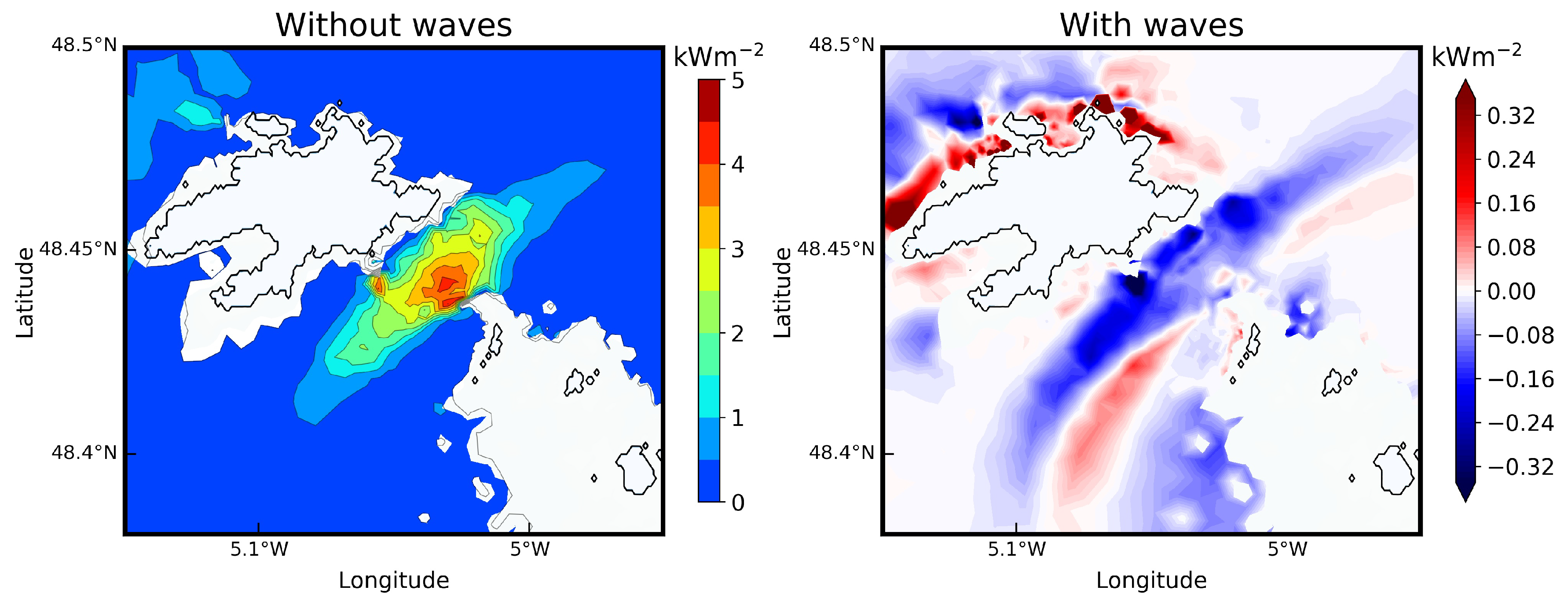
Among the different metocean conditions liable to impact the available resource of the Fromveur Strait, wind-generated surface-gravity waves have to be considered. Indeed, as exhibited in Section 3.3, the Ushant-Molène archipelago is exposed to strong incoming waves subjected to depth- and current-induced refractions and therefore liable to reach the Fromveur Strait. These wave energetic conditions may thus impact the tidal currents and the associated kinetic energy of the strait. Two well-known nonlinear processes were identified: (i) the increase of the apparent bottom friction felt by currents above the wave boundary layer and (ii) the generation of wave-induced currents [45,46]. In the Fromveur Strait, Guillou et al. [23] quantified these effects by coupling a tidal circulation model with a phase-averaged spectral wave model. The inclusion of wave effects in the tidal model improves the comparison between predictions and measurements at the ADCP current meter located in the strait (Table 1 and Figure 2) by reducing peak of available kinetic power density by up to 9 % during storm conditions. Over the 4 k m 2 area targeted for array implementation, predictions exhibited furthermore a reduction by around 12 % of the mean spring tidal power density for westerly incoming storm waves (characterized by significant wave height H s of 5 m and peak period T p of 14.0 s). Waves appeared also to increase the lateral gradient of the tidal power density identified across the Fromveur Strait, thus resulting in a reduction of tidal kinetic energy more pronounced in the north-western area than in the south-eastern region (Figure 7). A detailed analysis of processes of wave and current interactions exhibited finally the importance of waves-driven currents in the shallow waters around shoals and islands of Ushant-Molène archipelago. Waves-driven currents were thus found to impact the tidal circulation while spatially redistributing the available kinetic energy resource between the strait and surrounding shallow-water areas. Considering waves temporal variability in western Brittany [38,39] (Section 3.3), further modifications and temporal variations of the available tidal stream energy resource are expected at the interseasonal and interannual time scales [3].

5. Energy Extraction

A refined assessment of the potential environmental impacts of tidal stream energy extraction constitutes another key step of turbines design and tidal farm layout, thus securing the long-term implementation of energy converters in the marine environment. As in-situ observations around devices are publicly not available or are submitted to private licenses, these investigations rely, most of the time, on numerical simulations. However, different approaches are adopted with respect to the capabilities of regional and local modeling. We review here the different investigations conducted in the Fromveur Strait by first focusing on large-scale environmental effects associated to tidal stream energy extraction. We exhibit then sizing and optimization studies based on (i) refined simulations of turbine wake interactions at the scale of the tidal farm and (ii) scenarios of hybrid energy production systems dedicated to turbines design with respect to a combined exploitation with other renewable resources including wind energy.

5.1. Environmental Impact Studies

5.1.1. Effects on Tidal Current and Bottom Shear Stress

Regional tidal circulation models do not have the capabilities to simulate the wake interaction at the scale of the turbine farm. For this reason, the simulation of large-scale modifications induced by tidal stream energy extraction is conducted by parameterising the effects of the tidal farm as an additional bed friction sink term included in the momentum equations of the circulation model. This sink term is implemented over the area targeted for energy exploitation (typically the area covered by the turbines array) and is determined by averaging the thrust and drag forces of individual devices [47,48]. As exhibited in Section 2.2, this approach, commonly denominated the distributed drag or continuous drag method, was applied in the Fromveur Strait in a series of high-resolution depth-averaged numerical simulations. Thus, Guillou and Thiébot [22] evaluated the impacts of a full energy extraction scenario (corresponding to a series of 1-MW horizontal-axis turbines occupying the overall 4 k m 2 area targeted for devices implementation) on tidal currents and bottom shear stresses, this latter parameter being considered as an indicator of changes induced in sediment transport. Modifications predicted after including turbines were consistent with simulations conducted with the distributed drag method in broader tidal stream energy sites by exhibiting (i) a reduction of currents magnitudes inside the array, both upstream and downstream and (ii) an acceleration on the side of the flow passing the array location within the strait [49,50] (Figure 8).
Confirming numerical investigations in energetic locations of north-western Europe [47,49], changes in velocity magnitudes extended at several kilometres from the tidal farm with a reduction of depth-averaged currents over 10 % . In the Ushant-Molène archipelago, simulations for a full energy extraction scenario exhibited thus a decrease of current magnitude over 0.10 m s 1 which extended up to 15 km from the array in peak ebb of a mean spring tide (Figure 8). Such large-scale effects were also found to impact bottom shear stresses. These modifications were exhibited over the sand bank of the Four, in the north-eastern part of Ushant-Molène archipelago, with a reduction up to 12 % of the maximum bottom shear stress predicted during a mean spring tidal cycle. Potential increase of sediments deposition were expected over this seabed feature in relation to an extended exploitation of the tidal stream energy resource of the Fromveur Strait.

5.1.2. Effects on the Lagrangian Residual Circulation

Beyond impacts on hydrodynamic parameters and sediment transport, particular attention was dedicated to wide changes of tide-induced circulation and water-particles displacement. Indeed, these aspects are fundamental to gain further insights on potential effects of an operating turbine array on the quality of marine waters. Tidal straits contribute thus to important transport of water in coastal marine systems, and tidal stream energy extraction is liable to modify the circulation pathway while impacting the trapping and dispersion of dissolved nutriments and pollutants (including oil and persistent toxins), particulate organic matters (e.g., plankton, gametes, larvae), and suspended sediments [51]. These different aspects are very important in the area of interest, integrated in the Iroise biosphere reserve, recognized since 1988 by Unesco, with high environmental constraints to guarantee water quality standards and biodiversity preservation.
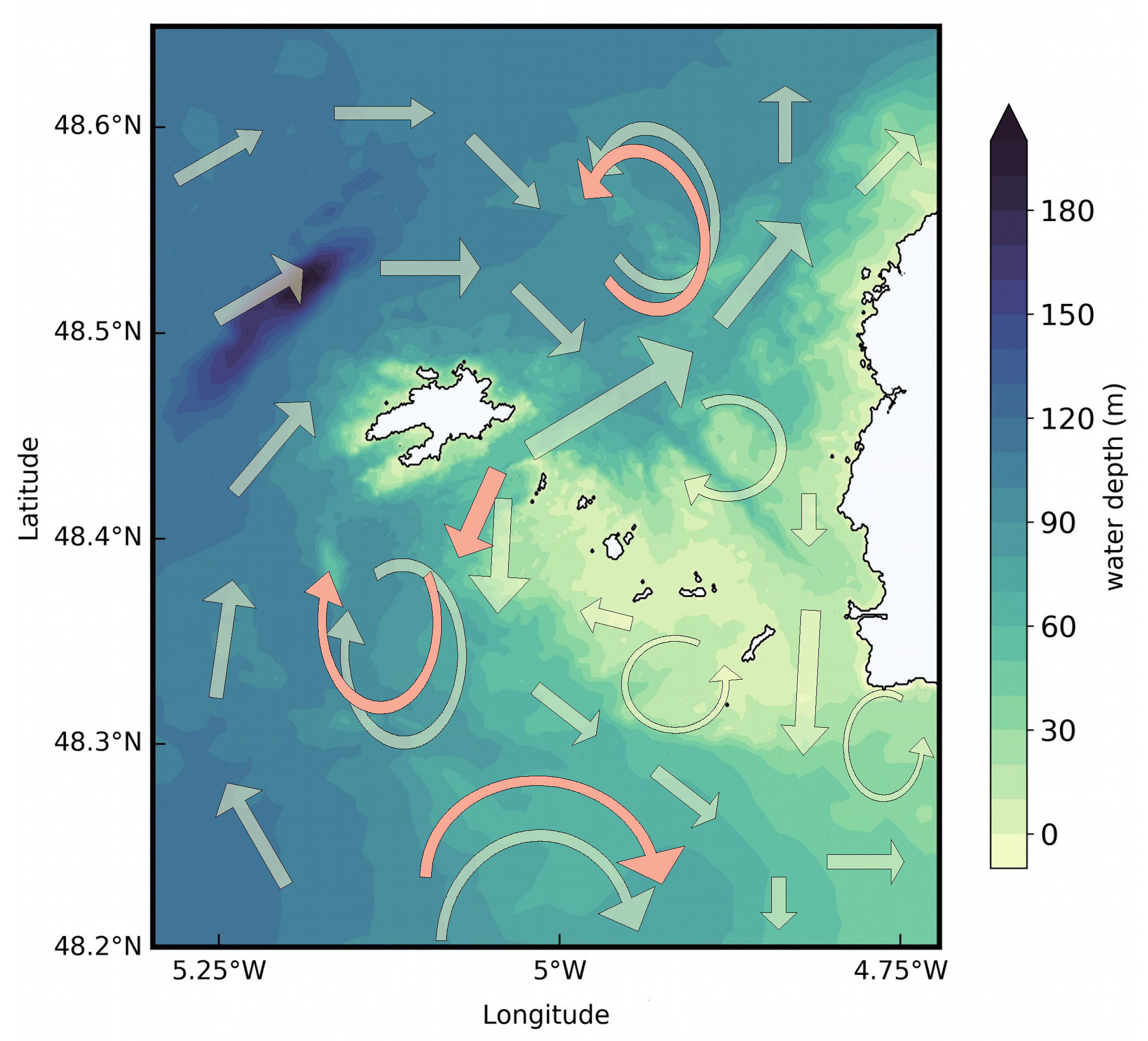
In the Fromveur Strait, these aspects were investigated by assessing modifications of the tide-induced circulation pathways for the principal semidiurnal harmonic component M 2 [24,28]. Circulation pathways were assessed in a single synoptic view by applying the original Lagrangian barycentric method proposed by Salomon et al. [52]. This method applies the Lagrangian residual currents—defined as the displacements of drifters during a M 2 tidal cycle—at the barycentres of predicted trajectories, this in order to reduce the dispersion of the residual velocity field associated with the influence of the initial release time. Further details about this method are available in [52,53,54]. The resulting cartography revealed a complex Lagrangian Residual Circulation (LRC) highly controlled by bathymetry gradients and islands geometry (Figure 9).
Partly associated with the asymmetry of tidal currents in the Fromveur Strait, the LRC exhibited especially a strong asymmetry in the central strait between (i) a prominent north-eastern pathway with residual currents up to 0.45 m s 1 and (ii) a southward circulation with residual currents restricted to 0.20 m s 1 [28]. Prominent cyclonic and anticyclonic recirculations, with diameters of around 8 km, were furthermore identified both upstream and downstream the strait. Thus, the LRC placed the northern eddy close to the bank of the Four, and this correlation was also obtained by removing the sandbank from the bathymetry. The extraction of tidal stream energy, predicted with the distributed drag approach, induced furthermore changes in (i) the magnitude and direction of residual currents emerging from the strait and (ii) the locations of surrounding eddies with a tendency to get closer to the tidal array [24] (Figure 10).
For a full energy extraction scenario, the positions of the southern and northern eddies were thus displaced by 3 and 1.7 km, respectively. This confirmed the potential effects of operating turbines on the evolution of surrounding seabed features exhibited in previous Section 5.1.1.

5.1.3. Effects on Water Renewal

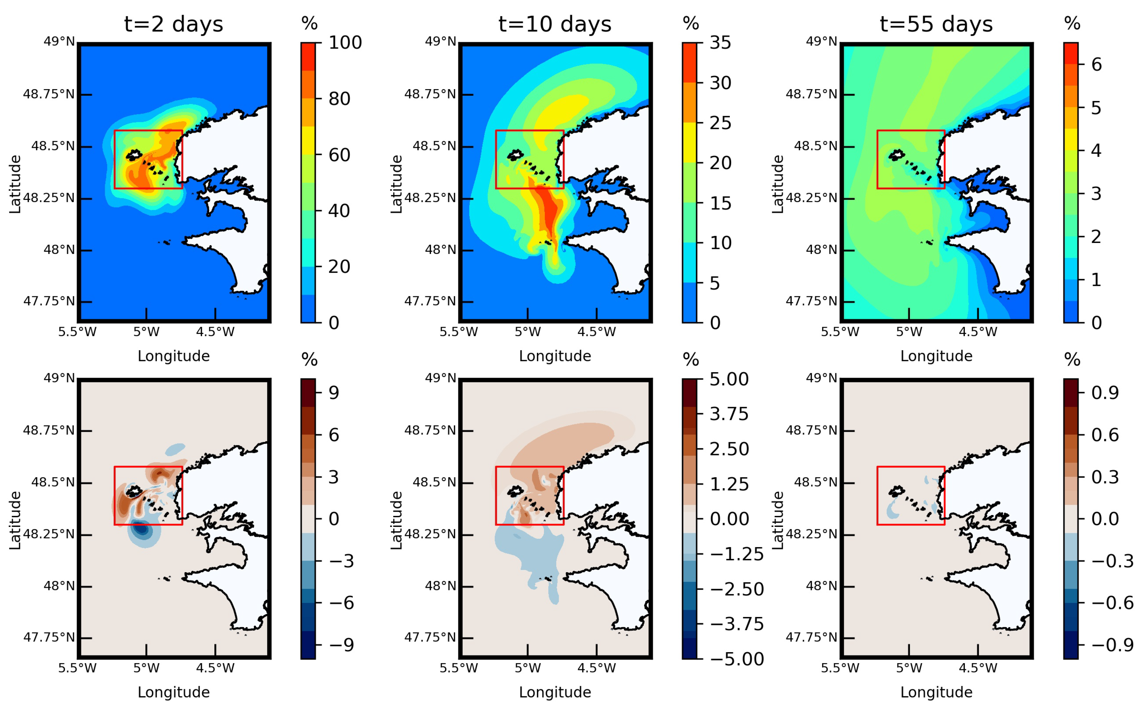
Complementing this investigation of the LRC, the ecological robustness of the marine system was evaluated by (i) simulating the decay of a tracer concentration within a control domain surrounding the Ushant-Molène archipelago and (ii) evaluating changes to tidal stream energy extraction [12]. The attention was therefore dedicated to the evolution of the concentration of a neutrally-buoyant dye averaged within the control domain (between longitudes 5.23 ° W and 4.74 ° W and latitudes 48.30 ° N and 48.58 ° N ) and over M 2 tidal cycles (as tidal oscillations may influence the evaluation of times concentration decay) (Figure 11).
Predictions exhibited the important renewal capacity of this marine environment with a loss of almost half of the initial tracer concentration in less than three days for idealized M 2 M 4 compound tide. However, the long-term evolution was characterized by a reduced dynamics with residual values over 1 % being still present after a period of 2.5 months. Such estimation appeared consistent with numerical investigations in the Liverpool Bay (UK) [55]. However, these results confirmed also that the concentration decay could not be calibrated by simple exponential functions as traditionally considered in estuaries and multi-inlet bays systems to avoid long computational time for the approach of transport time descriptors (such as the residence or flushing times). Indeed, calibrating the concentration decay with exponential functions was found to overestimate the renewal capacity of this marine environment, thus underestimating water renewal times. The renewal time of marine water was therefore evaluated by (i) computing the long-term evolution of tracer concentration within the control domain and (ii) evaluating the durations required for the tracer concentration to decrease by percentiles of the initial concentration (e.g., 50%, 30%, 10%, and 2 % ).
Given the short-term energetic conditions and the complex LRC identified in the Ushant-Molène archipelago, the decay of the tracer concentration within the control domain revealed important differences with respect to (i) the tidal range and (ii) the initial release time during the tidal cycle. Highest renewal times were thus obtained for releases in the vicinity of the high tide, thus matching the highest amount of tracer mass injected in the marine environment. Nevertheless, a full energy extraction scenario resulted in weak changes of the renewal capacity of the Ushant-Molène archipelago. Thus, modifications in the renewal times of tracer concentration were restricted to 5.3 % for the different percentiles considered. In the early days of tracers release, local trapping areas were, however, identified in the vicinity of Lagrangian recirculations both upstream and downstream the Fromveur Strait (Figure 11). This confirmed the potential effects of the turbine array on these residual eddies. These effects were found to vanish after two months with differences below 0.5 % off western Brittany. Beyond a simple evaluation of transport time descriptors (with averaged values within a control domain), a synoptic investigation is therefore required to assess the potential environmental impacts of a tidal turbine array in the Fromveur Strait.

5.2. Sizing and Optimization Study

5.2.1. Optimization of Turbine Location According to Technological Options

Minimizing maintenance operation is a key point for the future deployment of tidal stream turbines at commercial level. Thus, numerous companies and projects propose designs of fixed-axis turbines to avoid a yaw mechanism, which can be subjected to failures and therefore induce extra-maintenance operations. Another interesting option in terms of maintenance cost minimization is to use fixed-pitch turbines with symmetrical behavior (the turbine can be used indifferently in the two flow directions) to avoid pitch mechanism [56]. These two options have been chosen by the French company Sabella for the 10-m diameter turbine implemented in the Fromveur Strait [56,57].
As a first approximation, these two options appear relevant in potential tidal stream energy sites as tidal currents are often considered by designers to be perfectly symmetrical with ebb and flood currents oriented along a common axis. However, as exhibited in Section 3.2 and Section 4.1.1, the Fromveur Strait is characterized by important asymmetry in tidal current magnitudes and directions between peak ebb and flood, and the assumptions for the two technological options of fixed-pitch turbines with symmetrical behavior are not fully satisfied. Thus, an accurate characterization of tidal currents distribution, both in space and time, is required to assess and optimize (i) the technological option choices and (ii) the suitable location to install tidal stream turbines in the strait.
El Tawil et al. [17] proposed a method to determine the optimal turbine locations in terms of energy harnessing around the island of Ushant including the Fromveur Strait. Optimal axis direction of fixed-axis turbine and comparison of energies harnessed by a yawed and a fixed-axis turbine were calculated in any location of the Ushant-Molène archipelago. The method adopted was based on the recomposition of long-term time and spatial series of tidal current velocities from predictions established in spring and neap conditions and the evolution of the tidal range in the area of interest. Regardless of advanced economical considerations on the cost associated with the design of the different technologies (with respect to metocean conditions), the achieved results allow identifying the locations which are the most adapted to yawed and fixed-axis turbines in terms of energy harnessing.

5.2.2. Turbine Wake Interactions and Array Configuration

Beyond the choice of the optimal technological option for tidal stream turbines, a refined estimation of the generated technical resource is another key point for the design of devices. Preliminary assessments of the energy produced by turbines may be reached by combining (i) devices power curves with (ii) predictions of tidal velocities in the location targeted for array implementation [10]. However, the development of more reliable kinetic energy converters require advanced evaluation of the technically exploitable resource by relying on an accurate representation of the interactions between devices’ wakes and the ambient flow field. Among the different techniques considered to simulate the effects of individual turbines on the tidal flow, the Actuator Disk (AD) method appears as a simple and efficient approach to represent wake interactions within a given array [58]. This method is adapted to horizontal-axis turbines, thus representing the device as a porous disk whose resistance to the flow field is included as a sink term in the momentum equation.
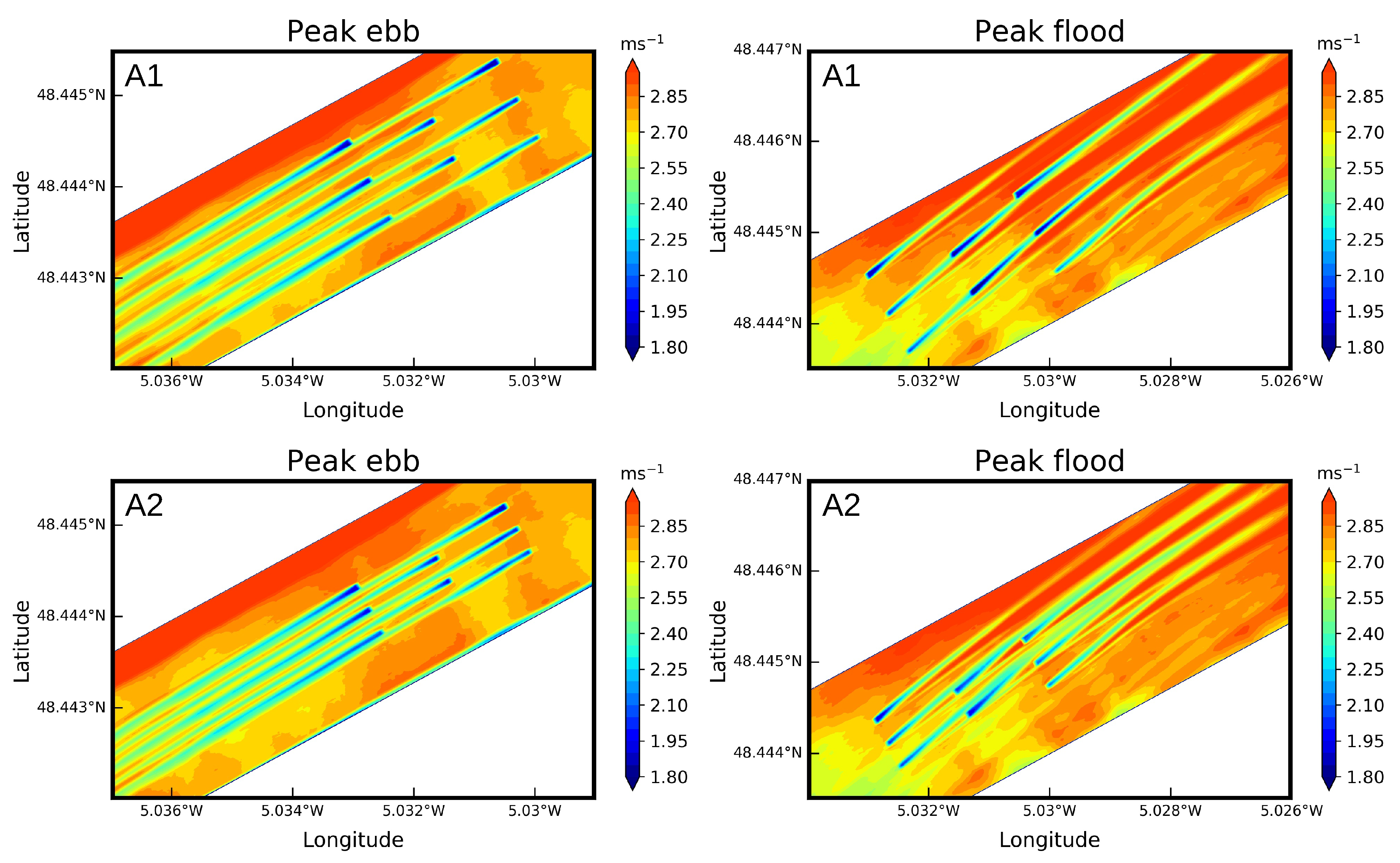
Such a technique was applied by Michelet et al. [25] in the fully three-dimensional Regional Ocean Modeling System (ROMS) [29] to investigate turbine wake interactions in the Fromveur Strait, thus reaching a promising improvement to the distributed drag method considered in regional impact studies (Section 5.1). Horizontal-axis turbines with a diameter of 10 m were considered matching the device technology operating by Sabella in the strait. Following the objective of meeting between 15% and 20 % of the electricity demand of the island of Ushant, the investigation considered an array of eight devices with axes positioned along the peak ebb current direction (Figure 12). Simulations were conducted at the scale of the array with horizontal and vertical resolutions of 1 m, matching spatial resolutions requested to resolve velocity and turbulence intensity along turbine wakes. Boundary conditions derived from the application of three-embedded computational domains orientated along the peak ebb direction and covering the Sea of Iroise, the Ushant-Molène archipelago and the tidal array, respectively. The array was positioned in the central divergence area of the strait to restrict variations in energy extraction between peak ebb and peak flood (Section 4.1.1, Figure 6).
Two array configurations were successively considered. The array layout A1, initially adopted, followed staggered configurations recommended to limit wake interactions and optimize energy production, thus adopting longitudinal spacing of 10D and lateral spacing of 5D (measured center to center with D the turbine diameter) [59]. However, the misalignment of peak flood currents was leading to important wake interactions, thus reducing the energy produced by nearly 15 % in comparison to peak ebb of a mean spring tidal cycle (Table 3).
An optimized configuration A2 adapted to tidal current conditions of the Fromveur Strait was therefore proposed to restrict turbine wake interactions at peak flood, thus reducing the lateral spacing between devices to 3D. Such a reduction in lateral spacing weakened the effect of wake overlap, while enhancing the generation of turbulent kinetic energy and the velocity recovery downstream (Figure 12). This new array configuration reached therefore a more balanced energy output between peak ebb and flood with a difference below 2 % and reduced alteration of the flow field and energy produced at peak ebb (Table 3). Whereas improvements in the implementation of the AD method may be reached, such a refined study of turbine wake interactions in the Fromveur Strait provided preliminary information to optimize array layout before exploiting advanced in-situ observations in the wake of devices.

5.2.3. Hybrid Energy Systems

The island of Ushant is not connected to the French power grid and has been until now supplied by diesel generators connected to a stand-alone electrical grid. This configuration is (i) costly in terms of fuel import, (ii) not fully resilient, and (iii) results in significant carbon dioxide and pollutant emissions in a well-known natural protected area recognized as a biosphere reserve by Unesco (Section 5.1.2). This is why installation of MW size marine current turbines in the Fromveur Strait can be an interesting opportunity to increase the energetic autonomy of the island of Ushant while minimizing carbon dioxide and pollutant emissions [56,57]. However, even if the power harnessed by turbines is roughly predictable, this power is characterized by a high-temporal variability exhibited over semidiurnal and fortnightly time scales but also influenced by superimposed effects of metocean conditions including wind and waves (Section 4.1). Higher-frequency variations may furthermore appear in relation to wind, waves, or turbulence disturbances liable to result in unpredictable quick fluctuations with time-constant of about few seconds [60]. Considering the power supply requirements of an island, these variations are not reasonably acceptable. On one hand, in a stand-alone electricity grid, it is strictly needed that the power is injected to the grid balance, at any time, for the consumed power to guarantee the grid stability and the consumer supply. On the other hand, quick variations of power supply are leading to grid instability and system-accelerated aging. This is why solutions based on the hybridization of tidal stream turbines with other power resources and energy storage systems have been proposed.
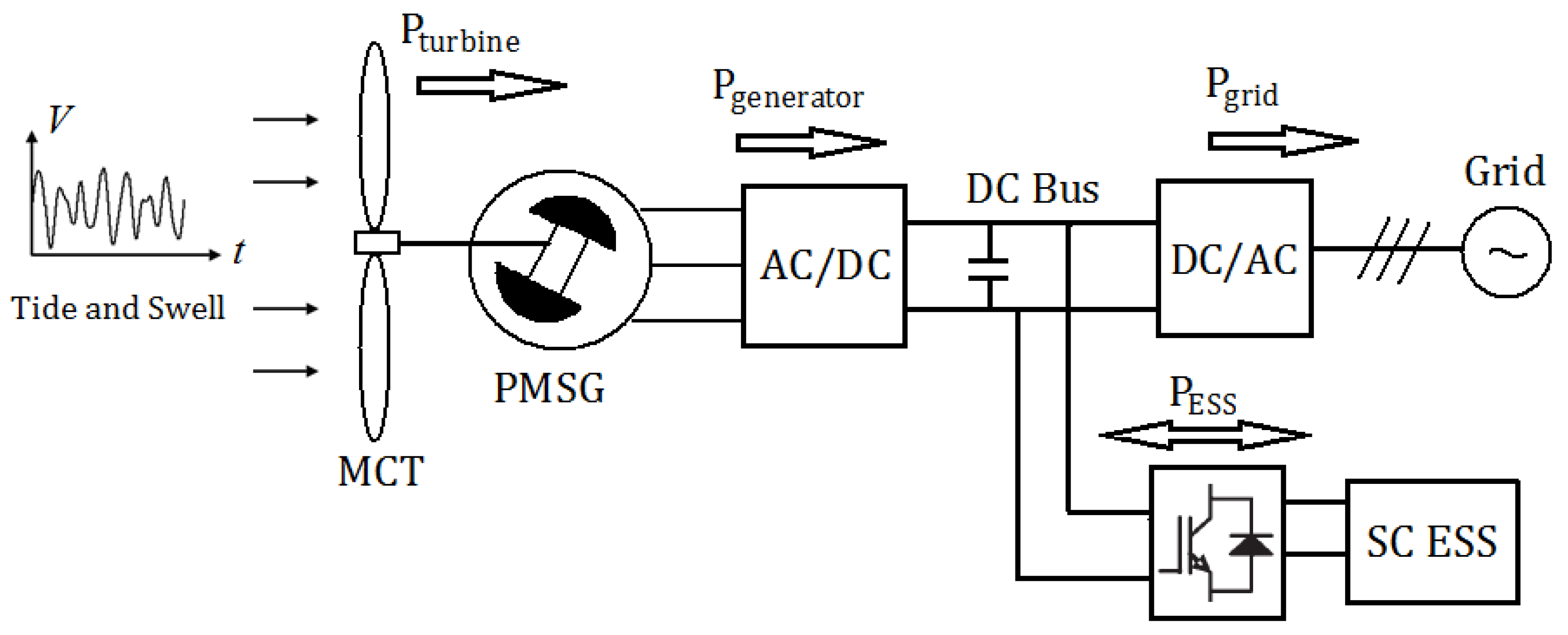
For short time fluctuations, Energy Storage Systems (ESS) with small energy capacity and high power capacity can be associated to each turbine power electronics drive to limit the short term power fluctuation in power production (peak shaving and power smoothing). Zhou et al. [61] proposed therefore a small size supercapacitor ESS to be associated to a 1.5-MW fixed-pitch tidal turbine for this purpose (Figure 13). This kind of supercapacitor-based ESS was also proposed and designed to be associated with the Sabella D10 turbine in the Fromveur Strait to limit the impacts of short-term power variations on the operation and stability of the local grid of the island of Ushant [62,63,64]. A real scale prototype has been built and tested in a dedicated power emulation test bench in ENTECH SE Company Facilities (Quimper, western Brittany) [64]. Tests and simulations were conducted using realistic resource time series, thus confirming the efficiency of the proposed association.
In order to face the more long-term variation of tidal currents, some studies proposed to associate turbine system to a specific ESS able to store a significant part of the produced energy during the tidal cycle. Therefore, association of a new generation of battery (Vanadium Redox Flow battery) with a tidal stream turbine located in the Fromveur Strait and diesels generators was investigated in Zhou et al. [65], this in order to supply the island of Ushant while minimizing the use of fuel.
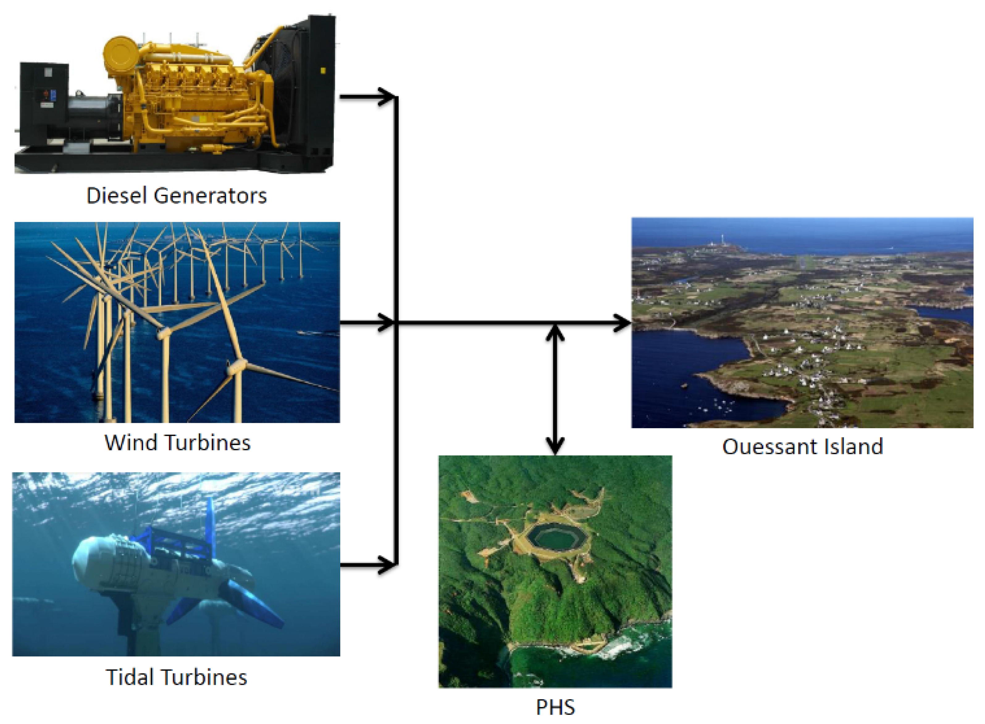
Other studies investigated different turbines hybridization options for the local grid of the island of Ushant including the exploitation of other renewable energy sources such as wind turbines and photovoltaic (PV) systems, in addition to ESSs [66,67]. In [66], a methodology was thus proposed to determine, from tidal and wind resources characterization, the optimal design of a hybrid energy microgrid for the island. Whereas this strategy was applied to the specifications of the island of Ushant [65], it may also be adapted to other stand-alone configurations where a combination of tidal stream energy and other renewable energy may be investigated. These different exploitations of renewable energies based on microgrid may be implemented by relying on real time smart energy management strategy. For the island of Ushant, the system includes (i) wind turbines, (ii) tidal stream turbines located in the Fromveur Strait, (iii) a pumped hydro energy storage system, and (iv) diesel generators as shown in Figure 14.
The design methodology aims to minimize both carbon dioxide emissions and system costs including OPerational EXpenditure costs (OPEX) and project cost CAPital EXpenditure (CAPEX). Even if there are uncertainties to consider in the used models (e.g., costs, consumption), the results obtained in [65] demonstrated that a well chosen combination of renewable energy sources including tidal stream turbines and ESS can lead to (i) a strong reduction of greenhouse gas emission (about 10 % of the initial emissions) and (ii) a significant reduction of the global costs of the system (about 50 % ). In [67], a hybrid energy system including a tidal stream turbine, a PV system, a diesel generator, and a Li-ion battery pack was finally studied for supplying the island of Ushant, and a smart power management strategy was proposed in order to reduce operating and maintenance costs.
All these studies have shown that hybridizing marine current turbines located in the Fromveur Strait with ESSs and other renewable energy sources seems to be the solution of choice to provide clean and reliable energy for the remote island of Ushant.

6. Conclusions

This review draws the line on a series of investigations dedicated to the tidal stream energy resource of the Fromveur Strait and exploitation by horizontal-axis turbines, matching the operating technology in this environment. Whereas these studies are clearly site specific, such a review encompasses a variety of methods to gain further insights about energy exploitation that may be applied in other potential tidal stream energy sites. Beyond the simple identification of bulk parameters (such as the averaged or maximum tidal velocities), such advanced methods may thus help to optimize the design and location of turbines in the marine environment. Particular attention was dedicated to the spatial and temporal variability of available and technically exploitable resources but also to the potential environmental impacts of an operating turbine array. Objectives and approaches adopted clearly depend on the reliability of available data issued from (i) observations, (ii) hindcast databases, or (iii) numerical simulations specifically implemented for resource assessments. The main outcomes of the present review are as follows:
  • Tidal analysis can expose the temporal variability of the available resource. The exploitation of high-resolution tidal current harmonic databases identified therefore (i) areas with diurnal inequalities (characterized by unequal magnitude of current velocities between peak ebb and flood) and (ii) areas with lunar inequalities (characterized by noticeable differences in current magnitudes between neap and spring conditions). Thus, the Fromveur Strait exhibited a central divergence region with reduced semidiurnal asymmetry which appeared desirable for the implementation of horizontal-axis turbines. In comparison with offshore locations of western Brittany, this central area exhibited furthermore low spring-neap variability, thus promoting this location for tidal energy conversion.
  • The Fromveur Strait was characterized by strong wave and current interactions, revealed by the tidal modulations of the significant wave height in surrounding wave buoy stations. These effects, quite typical of tidal straits exposed to oceanic waves, were reinforced by depth- and current-induced refractions. Advanced numerical resource assessments coupling wave and tidal circulation models exhibited a reduction by around 12 % of the mean spring tidal power density during storm conditions. Waves were furthermore increasing the lateral gradient of tidal power density identified between the island of Ushant and islets and shoals of the northern part of Molène archipelago.
  • A series of regional impact studies were conducted by relying on the distributed drag method in high-resolution numerical simulations of the tidal circulation off western Brittany. For a full energy extraction scenario, predictions exhibited noticeable reduction, over 10 % , of depth-averaged currents magnitudes at several kilometers from the array. These modifications impacted also the bottom shear stresses and the tide-induced Lagrangian circulation, thus suggesting potential effects on surrounding seabed sand features (in particular the sand bank of the Four in the north-eastern part of the archipelago).
  • The Ushant-Molène archipelago showed, however, important ecological robustness to hydrodynamic changes induced by operating turbines. This environment was thus characterized by strong renewal capacity of marine waters with an evacuation of nearly 50 % of the initial water mass in less than three days. The long-term evolution exhibited, however, residual values of an initial tracer concentration after a period of several months. Simulations suggested negligible turbines effects on the renewal capacity of this marine environment. Nevertheless, the extraction of tidal stream energy from the strait increased locally the tracer concentration in the early days of tracers release. Local trapping areas were thus identified in the vicinity of Lagrangian residual eddies both upstream and downstream the strait but vanished after a period of two months.
  • A refined characterization of the spatial and temporal variability of tidal current velocity is a prerequesite to optimize the technological option choices and location of tidal stream turbines suitable for yawed and/or fixed-axis devices. Beyond these preliminary investigations, an advanced assessment of the generated technical resource is required to complete the design stage of a tidal farm, thus simulating the local interactions between turbines’ wakes and the ambient flow field.
  • In the Fromveur Strait, refined simulations of turbine wake interactions suggested to reduce the lateral spacing between devices, thus restricting wake overlap and increasing the energy produced during peak flood characterized by misalignment of tidal currents with respect to array orientation.
  • This optimized array layout has, however, to be configured with respect to the hybridization of tidal stream turbines with other resources and energy storage systems, this in order to mitigate short- and more long-term fluctuations of power supply injected in the grid balance. Investigations conducted in the island of Ushant suggested to rely on Energy Storage Sytems to restrict the short term power fluctuation in power production. Advanced sizing and optimization studies promoted furthermore the combination of tidal turbines with wind devices, diesel generators, and pumped hydroelectric storage to secure the energy distribution, guarantee the cost of renewable energy and minimize carbon dioxide emissions for energy production of this stand-alone marine island territory.
Beyond the identification of areas with maximum tidal current magnitude, tidal stream energy resource assessments require therefore (i) refined tidal analysis (exploring the contribution of harmonic components to the temporal variability of the available resource), (ii) advanced investigations of the potential modulations of metocean conditions (such as effects of oceanic waves in tidal straits separating island territories from the landmass), and (iii) numerical simulations predicting the potential effects of energy extraction at the regional scale and the scale of the tidal array. The Fromveur Strait is one of the tidal stream energy location where such a panel of studies was conducted. Given the size of such a strait, the numerical investigations require refined spatial resolutions which may restrict the time periods covered by simulations to a limited number of tidal cycles. This is especially the case for the investigation of turbine wake interactions at the scale of the array. However, coupling of the tidal circulation model with wave or tracer transport models may also impact the computational capabilities of regional simulations, and original technique such as the Lagrangian barycentric method may provide further insights about the long-term transport pathway in this marine environment. The application of these different methods to a real tidal stream energy site may finally benefit broader investigations by providing advanced resource characterizations and analyses, thus securing the key steps of a tidal farm project.

Author Contributions

N.G.: Conceptualization, Formal analysis, Writing—Original Draft, Writing—Review and Editing, Visualization, Supervision, Project administration. J.-F.C.: Conceptualization, Writing—Original Draft, Writing—Review and Editing. M.B.: Writing—Review and Editing. All authors have read and agreed to the published version of the manuscript.

Funding

This research received no external funding.

Acknowledgments

The present paper is a contribution to the research program DIADEME (“Design et InterActions des Dispositifs d’extraction d’Energies Marines avec l’Environnement”) of the Laboratory of Coastal Engineering and Environment (Cerema, http://www.cerema.fr).

Conflicts of Interest

The authors declare no conflict of interest.

References

  1. Authorities & Government. Tides Wash Away OpenHydro. 2020. Available online: https://www.offshore-energy.biz/tides-wash-away-openhydro/ (accessed on 17 December 2020).
  2. Lafleur, C.; Truelove, W.A.; Cousineau, J.; Hiles, C.E.; Buckham, B.; Crawford, C. A screening method to quantify the economic viability of off-grid in-stream tidal energy deployment. Renew. Energy 2020, 159, 610–622. [Google Scholar] [CrossRef]
  3. Guillou, N.; Neill, S.; Thiébot, J. Spatio-temporal variability of tidal-stream energy in north-western Europe. Philos. Trans. R. Soc. A 2020, 378. [Google Scholar] [CrossRef] [PubMed]
  4. Simec Atlantis Energy. Tidal Stream Projects MeyGen. 2020. Available online: https://simecatlantis.com/projects/meygen/ (accessed on 17 December 2020).
  5. EMEC. The European Marine Energy Centre LTD. 2020. Available online: http://www.emec.org.uk (accessed on 17 December 2020).
  6. Sabella. Sabella D10—France. 2020. Available online: https://www.sabella.bzh/en/projects/d10 (accessed on 17 December 2020).
  7. CMN (Constructions Mécanique de Normandie). 2020. Available online: https://cmn-group.com/hydroquest-ocean-6-mois-de-fonctionnement-continu/ (accessed on 17 December 2020).
  8. Orbital Marine Power. 2020. Available online: https://orbitalmarine.com/ (accessed on 17 December 2020).
  9. Robins, P.; Neill, S.; Lewis, M.; Ward, S. Characterising the spatial and temporal variability of the tidal-stream energy resource over the northwest European shelf seas. Appl. Energy 2015, 147, 510–522. [Google Scholar] [CrossRef] [Green Version]
  10. Guillou, N.; Neill, S.P.; Robins, P.E. Characterising the tidal stream power resource around France using a high-resolution harmonic database. Renew. Energy 2018, 123, 706–718. [Google Scholar] [CrossRef] [Green Version]
  11. Hashemi, M.; Neill, S.; Robins, P.; Davies, A.; Lewis, M. Effect of waves on the tidal energy resource at a planned tidal stream array. Renew. Energy 2015, 75, 626–639. [Google Scholar] [CrossRef] [Green Version]
  12. Guillou, N.; Thiébot, J.; Chapalain, G. Turbines’ effects on water renewal within a marine tidal stream energy site. Energy 2019, 189, 116113. [Google Scholar] [CrossRef]
  13. SHOM. Morpho-Sédimentologie et Courants de Marée 3D du Passage du Fromveur. 2020. Available online: https://www.data.gouv.fr/en/datasets/morpho-sedimentologie-et-courants-de-maree-3d-du-passage-du-fromveur/#_ (accessed on 17 December 2020).
  14. Mariette, V.; Thomas, N.; Cochin, V.; Guichoux, Y.; Ardhuin, F. Premiers résultats de l’expérience SURLITOP (Surveillance Littorale Opérationnelle. Annu. Navig. 2006, 54, 45–57. [Google Scholar]
  15. Sentchev, A.; Forget, P.; Barbin, Y.; Yaremchuk, M. Surface circulation in the Iroise Sea (W. Brittany) from high resolution HF radar mapping. J. Mar. Syst. 2013, 109–110, S153–S168. [Google Scholar] [CrossRef]
  16. Hervouet, J.M. Hydrodynamics of Free Surface Flows, Modelling with the Finite Element Method; Cambridge University Press: Cambridge, UK, 2007; p. 311. [Google Scholar]
  17. El Tawil, T.; Charpentier, J.; Benbouzid, M. Tidal energy site characterization for marine turbine optimal installation: Case of the Ouessant Island in France. Int. J. Mar. Energy 2017, 18, 57–64. [Google Scholar] [CrossRef]
  18. El Tawil, T.; Guillou, N.; Charpentier, J.F.; Benbouzid, M. On Tidal Current Velocity Vector Time Series Prediction: A Comparative Study for a French High Tidal Energy Potential Site. J. Mar. Sci. Eng. 2019, 7, 46. [Google Scholar] [CrossRef] [Green Version]
  19. Tondut, J.; Tawil, T.E.; Thiébot, J.; Guillou, N.; Benaouicha, M. A comparative study for tidal current velocity prediction using simplified and fast algorithms. Appl. Ocean Res. 2020, 104, 102346. [Google Scholar] [CrossRef]
  20. Lazure, P.; Dumas, F. An external-internal mode coupling for a 3D hydrodynamical model for applications at regional scale (MARS). Adv. Water Resour. 2008, 31, 233–250. [Google Scholar] [CrossRef]
  21. Pineau-Guillou, L. PREVIMER Validation des Atlas de Composantes Harmoniques de Hauteurs et Courants de Marée, Technical Report ODE/DYNECO/PHYSED/2013-03 version 1.0; IFREMER: Plouzané, France, 2013. [Google Scholar]
  22. Guillou, N.; Thiébot, J. The impact of seabed rock roughness on tidal stream power extraction. Energy 2016, 112, 762–773. [Google Scholar] [CrossRef]
  23. Guillou, N.; Chapalain, G.; Neill, S.P. The influence of waves on the tidal kinetic energy resource at a tidal stream energy site. Appl. Energy 2016, 180, 402–415. [Google Scholar] [CrossRef] [Green Version]
  24. Guillou, N.; Chapalain, G. Assessing the impact of tidal stream energy extraction on the Lagrangian circulation. Appl. Energy 2017, 203, 321–332. [Google Scholar] [CrossRef] [Green Version]
  25. Michelet, N.; Guillou, N.; Chapalain, G.; Thiébot, J.; Guillou, S.; Goward Brown, A.; Neill, S. Three-dimensional modelling of turbine wake interactions at a tidal stream energy site. Appl. Ocean Res. 2020, 95, 102009. [Google Scholar] [CrossRef]
  26. Guillou, N.; Thiébot, J. Environmental impact of a tidal stream farm: Predictions sensitivity to bottom roughness. In 15èmes Journées de l’Hydrodynamique; ENSTA Bretagne, Ecole Navale et IFREMER: Brest, France, 2016. [Google Scholar]
  27. Egbert, G.; Bennett, A.; Foreman, M. TOPEX/POSEIDON tides estimated using a global inverse model. J. Geophys. Res. 1994, 99, 24821–24852. [Google Scholar] [CrossRef] [Green Version]
  28. Guillou, N.; Chapalain, G. Evaluating the Effects of Tidal Turbines on Water-Mass Transport with the Lagrangian Barycentric Method. In Estuaries and Coastal Zones in Times of Global Change; Springer: Singapore, 2020; pp. 217–233. [Google Scholar]
  29. Shchepetkin, A.F.; McWilliams, J.C. The regional oceanic modelling system (ROMS): A split-explicit, free-surface, topography-following-coordinate oceanic model. Ocean Model. 2005, 9, 347–404. [Google Scholar] [CrossRef]
  30. Hamdi, A.; Vasquez, M.; Populus, J. Cartographie des Habitats Physiques Eunis—Côtes de France; Technical Report DYNECO/AG/10-26/JP; IFREMER: Brest, France, 2010. [Google Scholar]
  31. Thiébaut, M.; Sentchev, A. Estimation of Tidal Stream Potential in the Iroise Sea from Velocity Observations by High Frequency Radars. Special Issue: European Geosciences Union General Assembly 2015—Division Energy, Resources and Environment. Energy Procedia 2015, 76, 17–26. [Google Scholar] [CrossRef] [Green Version]
  32. Thiébaut, M.; Sentchev, A. Asymmetry of tidal currents off the W.Brittany coast and assessment of tidal energy resource around the Ushant Island. Renew. Energy 2017, 105, 735–747. [Google Scholar] [CrossRef]
  33. Pingree, R.D.; Holligan, P.; Head, R. Survival of dinoflagellate blooms in the western English Channel. Nature 1977, 265, 266–269. [Google Scholar] [CrossRef]
  34. Guillou, N.; Chapalain, G.; Duvieilbourg, E. Modelling impact of bottom roughness on sea surface temperature in the Sea of Iroise. Cont. Shelf Res. 2013, 54, 80–92. [Google Scholar] [CrossRef] [Green Version]
  35. Muller, H.; Blanke, B.; Dumas, F.; Lekien, F.; Mariette, V. Estimating the Lagrangian residual circulation in the Iroise Sea. J. Mar. Syst. 2009, 78, S17–S36. [Google Scholar] [CrossRef] [Green Version]
  36. Bentamy, A.; Croize-Fillon, D. Spatial and temporal characteristics of wind and wind power off the coasts of Brittany. Renew. Energy 2014, 66, 670–679. [Google Scholar] [CrossRef] [Green Version]
  37. Mattarolo, G.; Lafon, F.; Benoit, M. Wave energy resource of the French coasts: The ANEMOC database applied to the energy yield evaluation of wave energy converters. In Proceedings of the 8th European Wave and Tidal Energy Conference, Uppsala, Sweden, 7–10 September 2009. [Google Scholar]
  38. Guillou, N.; Chapalain, G. Numerical modelling of nearshore wave energy resource in the Sea of Iroise. Renew. Energy 2015, 83, 942–953. [Google Scholar] [CrossRef] [Green Version]
  39. Guillou, N. Evaluation of wave energy potential in the Sea of Iroise with two spectral models. Ocean Eng. 2015, 106, 141–151. [Google Scholar] [CrossRef]
  40. Guillou, N. Modelling effects of tidal currents on waves at a tidal stream energy site. Renew. Energy 2017, 114, 180–190. [Google Scholar] [CrossRef] [Green Version]
  41. Black and Veatch. UK Tidal Current Resource and Economics; Technical Report, Commissioned by the Carbon Trust and Npower, Project Number 121393; Black and Veatch: Overland Park, KS, USA, 2011. [Google Scholar]
  42. Pingree, R.D.; Griffiths, D.K. Sand transport paths around the British Isles resulting from M2 and M4 tidal interactions. J. Mar. Biol. Assoc. UK 1979, 59, 497–513. [Google Scholar] [CrossRef]
  43. Friedrichs, C.T.; Aubrey, D.G. Non-linear tidal distortion in shallow well-mixed estuaries: A synthesis. Estuar. Coast. Shelf Sci. 1988, 27, 521–545. [Google Scholar] [CrossRef]
  44. Guillou, N.; Chapalain, G. Tidal Turbines’ Layout in a Stream with Asymmetry and Misalignment. Energies 2017, 10, 1892. [Google Scholar] [CrossRef] [Green Version]
  45. Grant, W.; Madsen, O. Combined wave and current interaction with a rough bottom. J. Geophys. Res. 1979, 84, 1797–1808. [Google Scholar] [CrossRef]
  46. Longuet-Higgins, M.; Stewart, R. Radiation stresses in water waves; a physical discussion, with applications. Deep Sea Res. Oceanogr. Abstr. 1964, 11, 529–562. [Google Scholar] [CrossRef]
  47. Neill, S.; Jordan, J.; Couch, S. Impact of tidal energy convertor (TEC) arrays on the dynamics of headland sand banks. Renew. Energy 2012, 37, 387–397. [Google Scholar] [CrossRef]
  48. Plew, D.; Stevens, C. Numerical modelling of the effects of turbines on currents in a tidal channel - Tory Channel, New Zealand. Renew. Energy 2013, 57, 269–282. [Google Scholar] [CrossRef]
  49. Ahmadian, R.; Falconer, R.; Bockelmann-Evans, B. Far-field modelling of the hydro-environmental impact of tidal stream turbines. Renew. Energy 2012, 38, 107–116. [Google Scholar] [CrossRef]
  50. Ahmadian, R.; Falconer, R. Assessment of array shape of tidal stream turbines on hydro-environmental impacts and power output. Renew. Energy 2012, 44, 318–327. [Google Scholar] [CrossRef]
  51. Kadiri, M.; Ahmadian, R.; Bockelmann-Evans, B.; Rauen, W.; Falconer, R. A review of the potential water quality impacts of tidal renewable energy systems. Renew. Sustain. Energy Rev. 2012, 16, 329–341. [Google Scholar] [CrossRef]
  52. Salomon, J.C.; Guéguéniat, P.; Orbi, A.; Baron, Y. A Lagrangian model for long-term tidally induced transport and mixing. Verification by artificial radionuclide concentrations. In Radionuclides: A Tool for Oceanography; Guary, J.C., Guéguéniat, P., Pentreath, R.J., Eds.; Elsevier Applied Science Publishers: London, UK; New York, NY, USA, 1988; pp. 384–394. [Google Scholar]
  53. Salomon, J.C.; Breton, M. An atlas of long-term currents in the Channel. Oceanol. Acta 1993, 16, 439–448. [Google Scholar]
  54. Orbi, A.; Salomon, J.C. Dynamique de marée dans le Golfe Normand-Breton. Oceanol. Acta 1988, 11, 55–64. [Google Scholar]
  55. Phelps, J.J.C.; Polton, J.A.; Souza, A.J.; Robinson, L.A. Hydrodynamic timescales in a hyper-tidal region of freshwater influence. Cont. Shelf Res. 2013, 63, 13–22. [Google Scholar] [CrossRef]
  56. Zhou, Z.; Benbouzid, M.; Charpentier, J.F.; Scuiller, F.; Tang, T. Developments in large marine current turbine technologies—A review. Renew. Sustain. Energy Rev. 2017, 71, 852–858. [Google Scholar] [CrossRef]
  57. Paboeuf, S.; Sun, P.Y.K.; Macadré, L.; Malgorn, G. Power Performance Assessment of the Tidal Turbine Sabella D10 Following IEC62600-200. In Proceedings of the ASME 2016 35th International Conference on Ocean, Offshore and Arctic Engineering, Busan, Korea, 19–24 June 2016; Volume 6. [Google Scholar]
  58. Roc, T.; Greaved, D.; Thyng, K.M.; Conley, D.C. Tidal turbine representation in an ocean circulation model: Towards realistic application. Ocean Eng. 2014, 78, 95–111. [Google Scholar] [CrossRef]
  59. Bai, L.; Spence, R.R.; Dudziak, G. Investigation of the influence of array arrangement and spacing on Tidal Energy Converter (TEC) performance using a 3-dimensional CFD model. In Proceedings of the 8th European Wave and Tidal Energy Conference Series, Uppsala, Sweden, 7–10 September 2009; pp. 654–660. [Google Scholar]
  60. Jonsdottir, G.M.; Milano, F. Modeling of Short-Term Tidal Power Fluctuations. IEEE Trans. Sustain. Energy 2020, 11, 2337–2344. [Google Scholar] [CrossRef]
  61. Zhou, Z.; Scuiller, F.; Charpentier, J.F.; Benbouzid, M.E.H.; Tang, T. Power smoothing control in a grid-connected marine current turbine system for compensating swell effect. IEEE Trans. Sustain. Energy 2013, 4, 816–826. [Google Scholar] [CrossRef] [Green Version]
  62. Trabelsi, M.; Charpentier, J.; Scuiller, F.; Franquet, C.; Nicolas, E. Energetic Macroscopic Representation and Inversion-Based Control of a Grid-Connected MCT Power Generation System with Super-Capacitor Based Energy Storage Unit in Ushant Island. In Proceedings of the 2019 Offshore Energy and Storage Summit (OSES), Brest, France, 10–12 July 2019; pp. 1–9. [Google Scholar] [CrossRef]
  63. Trabelsi, M.; Charpentier, J.; Scuiller, F. Power Smoothing in MCT System with Supercapacitor Based Energy Storage for Islanded Grid. In Proceedings of the IECON 2019—45th Annual Conference of the IEEE Industrial Electronics Society, Lisbon, Portugal, 14–17 October 2019; Volume 1, pp. 7004–7009. [Google Scholar] [CrossRef]
  64. Molina, S.; Nicolas, E.; Trabelsi, M.; Scuiller, F.; Charpentier, J.; Franquet, C. A Real Scale Prototype to Smooth Short-Time Power Fluctuations of Marine Renewable Energy Sources-Uliss.EMR Project. In Proceedings of the 2019 Offshore Energy and Storage Summit (OSES), Brest, France, 10–12 July 2019; pp. 1–6. [Google Scholar] [CrossRef]
  65. Zhou, Z.; Benbouzid, M.E.H.; Charpentier, J.F.; Scuiller, F. Hybrid Diesel/MCT/Battery Electricity Power Supply System for Power Management in Small Islanded Sites: Case Study for the Ouessant French Island. In Smart Energy Grid Design for Island Countries; Green Energy and Technology Series; Springer International Publishing: New York, NY, USA, 2017; Chapter 13; pp. 415–445. [Google Scholar]
  66. El Tawil, T.; Charpentier, J.F.; Benbouzid, M. Sizing and rough optimization of a hybrid renewable-based farm in a stand-alone marine context. Renew. Energy 2018, 115, 1134–1143. [Google Scholar] [CrossRef]
  67. Zia, M.; Elbouchikhi, E.; Benbouzid, M.; Guerrero, J.M. Energy Management System for an Islanded Microgrid With Convex Relaxation. IEEE Trans. Ind. Appl. 2019, 55, 7175–7185. [Google Scholar] [CrossRef]
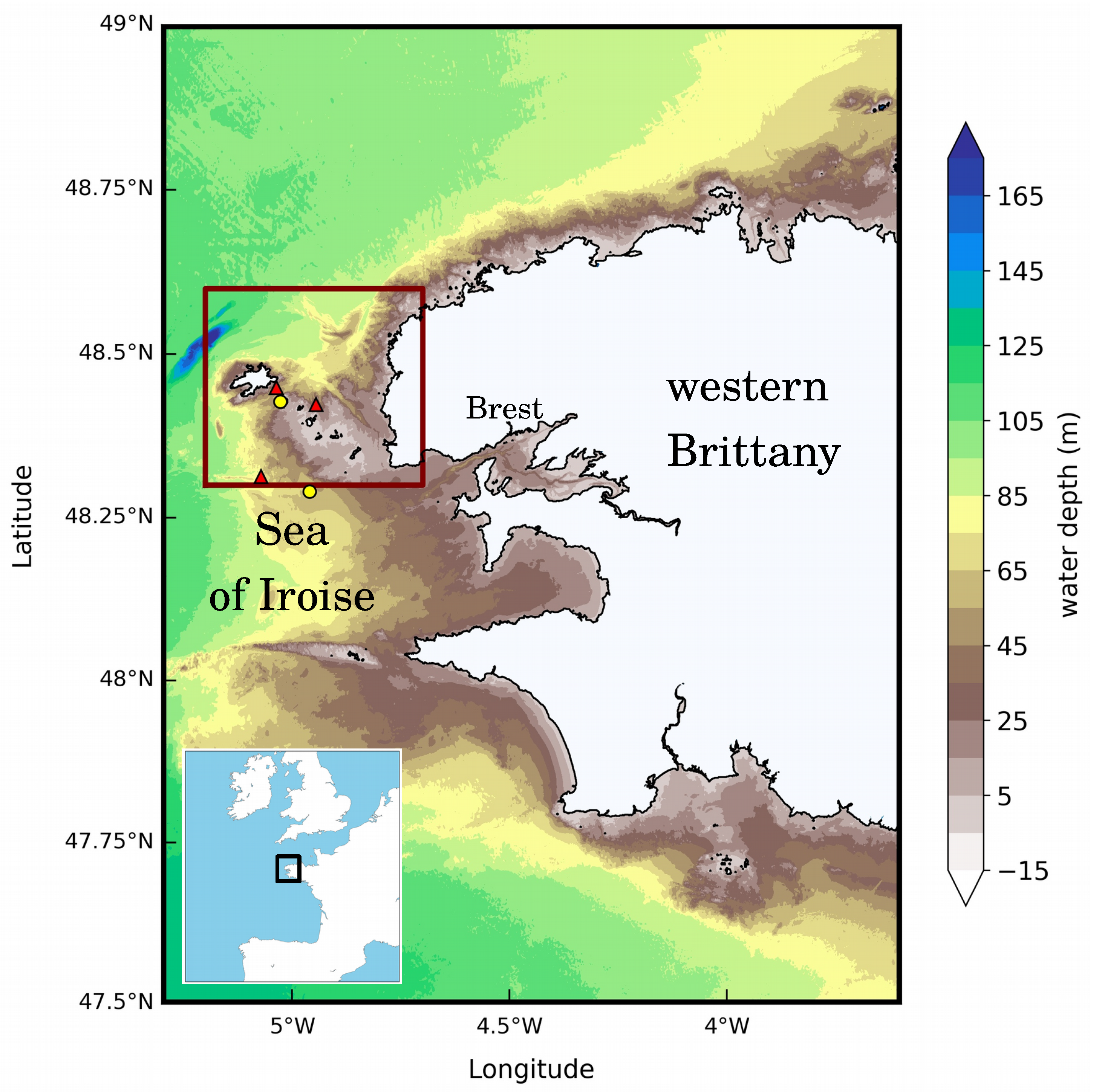
Figure 1. Mean water depth of western Brittany. Locations of current meters and wave buoys exploited in resource assessments are indicated with red triangles and yellow circles, respectively.
Jmse 08 01037 g001
Figure 2. (left) Mean water depth of Ushant-Molène archipelago. (right) High-resolution bathymetry of the Fromveur Strait referenced to the lowest astronomical tidal water level (french “zéro hydrographique” reference). To be consistent with Figure 1, locations of current meters and wave buoys over the two geographical areas are indicated with red triangles and yellow circles, respectively. The red line delimits the area of interest for the implementation of turbines within the Fromveur Strait.
Jmse 08 01037 g002
Figure 3. Sediment bottom types in and around the Fromveur Strait (adapted from [22,30]).
Jmse 08 01037 g003
Figure 4. (left) Peak magnitude of depth-averaged tidal currents resulting from M 2 , S 2 and M 4 harmonic components. (right) M 2 tidal current ellipses with ellipticity (defined as the ratio between magnitudes of the semiminor and semimajor axes of ellipses) shown as colorscale. Given the prevalent nature of M 2 over the northwest European shelf seas, low ellipticity accounts therefore for nearly rectilinear tidal currents whereas high ellipticity exhibits the circular nature of tidal currents. Blue and red ellipses indicate clockwise and anticlockwise rotations, respectively (adapted from [3]).
Jmse 08 01037 g004
Figure 5. Cartography of (left) averaged and (right) maximum kinetic power density during a spring-neap tidal cycle (T = 14.765 days) resulting from M 2 , S 2 and M 4 harmonic components (adapted from [3]).
Jmse 08 01037 g005
Figure 6. Spatial distribution of parameters (left) A a s y m and (right) A s n in the Ushant-Molène archipelago. The red line delimits the area of interest for the implementation of turbines within the Fromveur Strait.
Jmse 08 01037 g006
Figure 7. (left) Averaged predicted tidal stream power 10 m above the bed during a neap-spring tidal cycle in March 1993 (from 16 March, 16:55 UTC to 31 March, 15:35 UTC) without waves. The reference of 10 m corresponds to the operating height of horizontal axis turbines such as Sabella D10 in the strait. (right) Relative differences with respect to this reference simulation for the configuration with waves effects. Predictions are shown for mean water depths over 20 m. Positive values indicate an increase of mean tidal stream power, while negative values indicate reduced kinetic energy with the inclusion of waves effects (adapted from [23]).
Jmse 08 01037 g007
Figure 8. (left) Depth-averaged currents predicted without tidal stream array at peak ebb of a mean spring tide in the Ushant-Molène archipelago. (right) Differences in magnitude of depth-averaged velocities by integrating effects of a tidal stream array with the distributed drag method for a full energy extraction scenario. Positive and negative values account for increase and reduction of currents magnitudes with operating turbines, respectively (adapted from [22]).
Jmse 08 01037 g008
Figure 9. Streamlines from M 2 tidal residual Lagrangian currents within the Ushant-Molène archipelago (adapted from [24]).
Jmse 08 01037 g009
Figure 10. Interpretation of major features of residual Lagrangian currents patterns without tidal stream energy extraction in the Fromveur Strait. The major modifications induced by a full energy extraction scenario are shown with pink arrows (adapted from [24,28]).
Jmse 08 01037 g010
Figure 11. (top) Spatial distributions of the tracer concentration after 2, 10, and 55 days for an initial release at high tide of a M 2 tidal cycle within the control domain delimited with red line. Values are expressed in percentages of the initial tracer concentration imposed within the control domain and set to C i n i = 1 m 3 m 3 . (bottom) Spatial distributions of differences in tracer concentration between (i) the full energy extraction scenario and (ii) the baseline simulation without operating turbines. These differences are expressed in percentages of the initial tracer concentration C i n i . Positive values account for an increase of the tracer concentration with turbines whereas negative values exhibit a decrease of the tracer concentration (adapted from [12]).
Jmse 08 01037 g011
Figure 12. Horizontal plane maps of current magnitudes at peak ebb and flood of a mean spring tide in the Fromveur Strait for (top) the initial array layout A1 and (bottom) the optimized array configuration A2 that restricted wake interactions in peak flood (adapted from [25]). This horizontal plane grid corresponds to a reference elevation of 10 m above the bottom at a point located at the center of the computational domain. This reference plane may therefore be located below or above the different turbine centers but disregards the seabed variation focusing on wake horizontal evolution.
Jmse 08 01037 g012
Figure 13. Scheme of a Marine Current Turbine based on a Permanent-magnet synchronous generator and associated with supercapacitor ESS (from [61]).
Jmse 08 01037 g013
Figure 14. Hybrid energy system for the supply of the island of Ushant proposed in [66].
Jmse 08 01037 g014
Table 1. Description of current and wave measurement campaigns in Ushant-Molène archipelago.
InstrumentPointsCoordinatesWater DepthsPeriods
TypesLon.Lat.(m)of Measurements
C1 5.036 ° W 48.449 ° N 5319 March 1993 → 2 April 1993
CurrentC2 4.945 ° W 48.423 ° N 2914 May 1993 → 11 June 1993
MetersC3 5.071 ° W 48.313 ° N 8012 August 2012 → 23 August 2012
C4 5.403 ° W 48.496 ° N 11026 February 2006 → 9 March 2006
WaveW1 4.960 ° W 48.290 ° N 6015 October 2005 → 29 November 2019
BuoysW2 5.027 ° W 48.428 ° N 252 October 2012 → 17 April 2014
Table 2. Hindcast databases and numerical simulations exploited to characterize the tidal stream energy resource of the Fromveur Strait.
PurposesModelsTypes of Mesh2D/3DSpatial Res.
Reached
References
Harmonic databaseMARSRegular2DH250 m[10]
Harmonic databaseTelemac 2DUnstructured2DH50 m[3]
Resource and impact studiesTelemac 2DUnstructured2DH50 m[22]
Assessment of waves effectsTelemac 3DUnstructured3D50 m[23]
Turbines impact on
the Lagrangian circulation
Telemac 2DUnstructured2DH50 m[24]
Turbines impact on water renewalTelemac 2DUnstructured2DH50 m[12]
Turbine wake interactionsROMSRegular3D1 m[25]
Table 3. Power output at peak ebb and flood of a mean spring tide for array configuration A1 (initial) and A2 (optimized) (adapted from [25]).
ArrayPeak EbbPeak FloodDifference
Layout(MW)(MW)
A14.443.80 14.4 %
A24.534.47 1.3 %
Publisher’s Note: MDPI stays neutral with regard to jurisdictional claims in published maps and institutional affiliations.