Visual Localization for Deep-Sea Mining Vehicles During Operation


Abstract
1. Introduction
1.1. Background and Engineering Needs of Deep-Sea Mining
1.2. Limitations of Traditional Acoustic Navigation Methods
1.3. Visual Localization: Transitioning from SLAM to Map-Based Paradigm
1.4. Research Approach and Main Contributions
- (1)
- First application of AD-LG to deep-sea prior-map localization: We propose the AD-LG architecture by combining ALIKED’s deformable convolution feature extractor with LightGlue’s adaptive-depth Transformer matcher. To our knowledge, this is the first application of this architecture to prior-map-based visual localization in deep-sea nodule mining imagery, where non-rigid optical distortion and repetitive texture present challenges not addressed by existing benchmarks.
- (2)
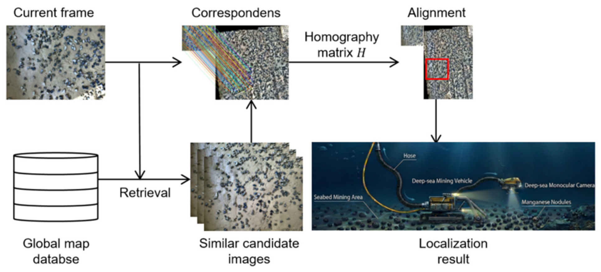
- Map-then-localize paradigm for deep-sea mining: Inspired by Google Cartographer’s 2D grid mapping philosophy, we establish a ‘map-then-localize’ framework that fundamentally eliminates cumulative drift by decoupling offline map construction from real-time localization. This paradigm has not been previously demonstrated in deep-sea mining vehicle navigation.
- (3)
- Adaptive keyframe extraction: We adapt a Laplacian variance combined with optical flow constraint strategy to the specific redundancy and motion characteristics of deep-sea AUV video, validated quantitatively against four comparison methods.
- (4)
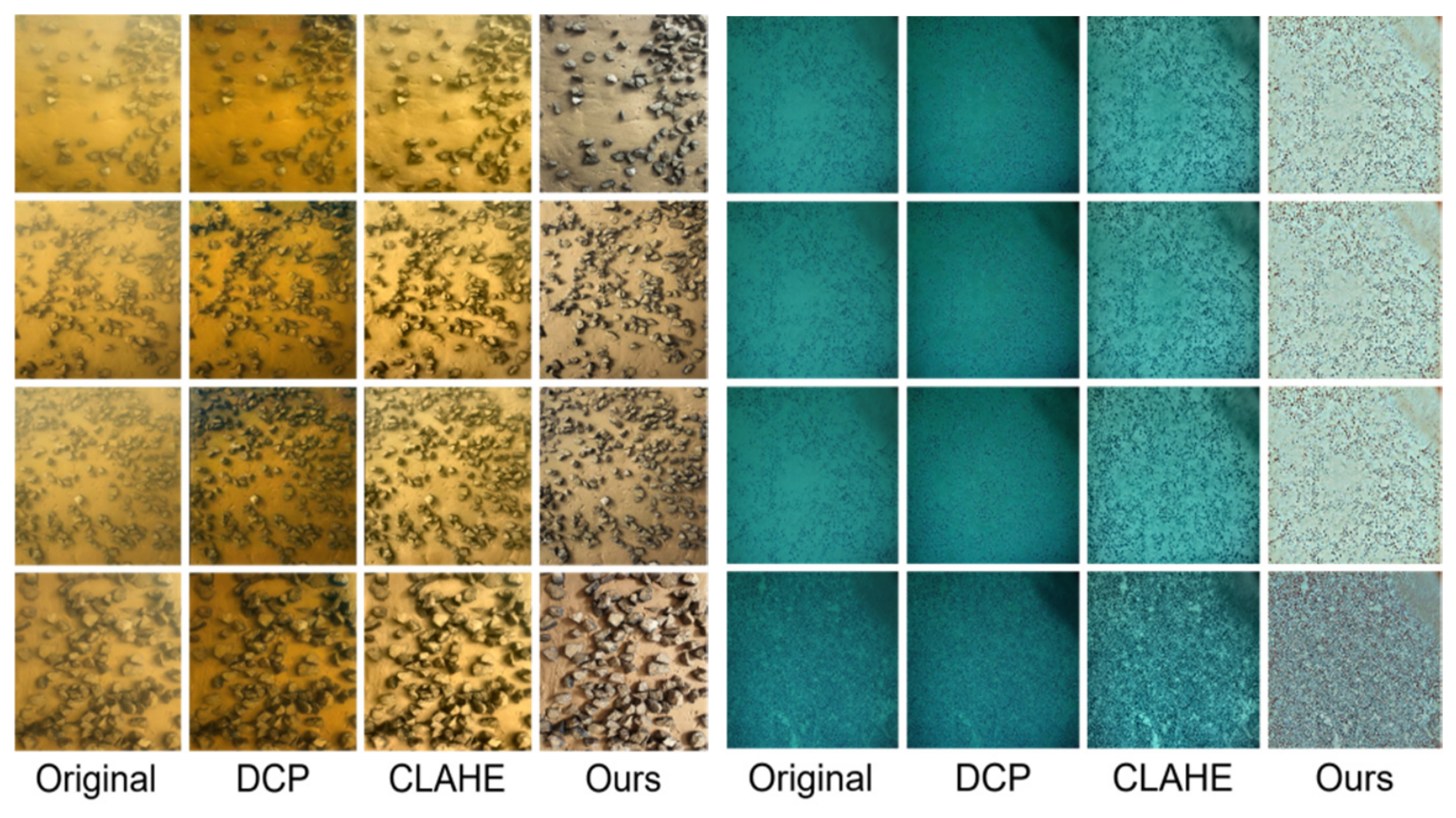
- MSR image enhancement: The Multi-Scale Retinex algorithm is selected and parameterised for the blue–green colour cast and uneven illumination characteristics of deep-sea mining imagery, with comparative validation against DCP and CLAHE.
- (5)
- Global bundle adjustment with multi-band blending: Standard BA and multi-band blending techniques are integrated into the pipeline and validated for drift correction in long-sequence deep-sea mosaicking.
2. Review of Related Work
2.1. Current State of Deep-Sea Navigation and Positioning Technologies
2.2. Advances in Underwater Visual Mapping and Localization
2.3. Development of Feature Extraction and Matching Methods
2.4. Underwater Image Enhancement Methods
3. Method and System Architecture
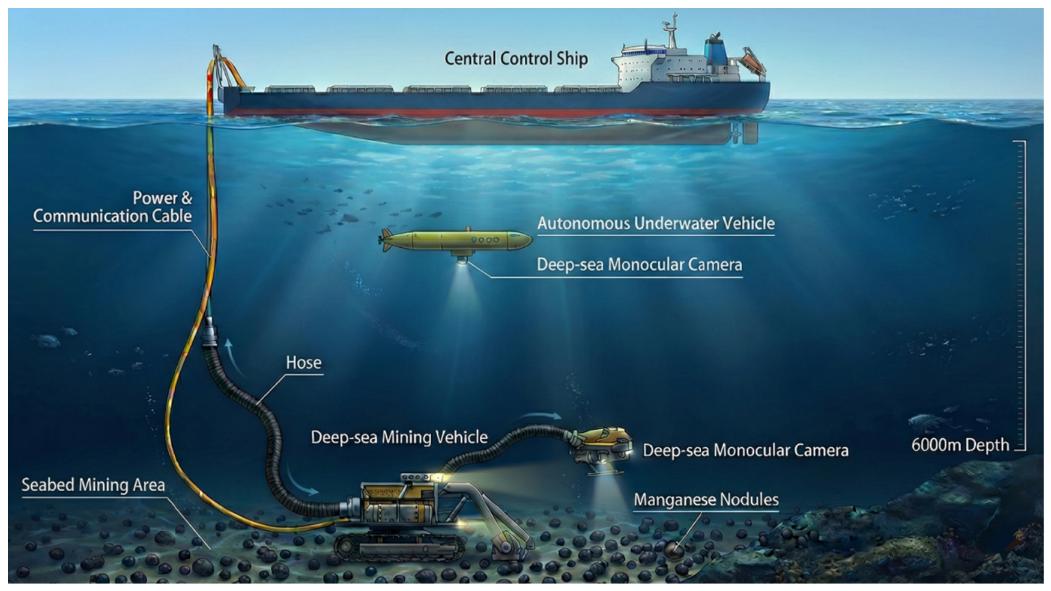
3.1. Overall System Framework
3.2. Coordinate System Definitions and Imaging Geometry Model
3.3. Adaptive Keyframe Extraction Strategy
3.4. Underwater Image Enhancement Based on MSR
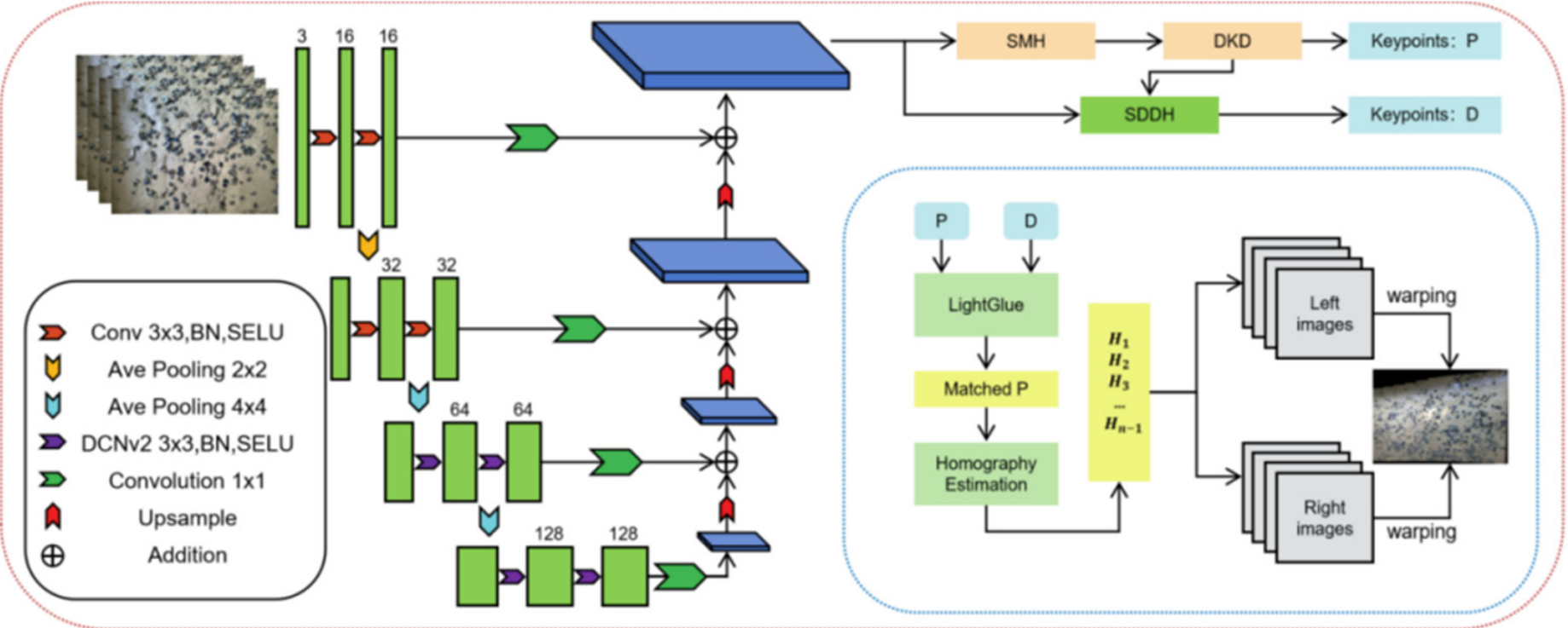
3.5. Feature Extraction and Matching Based on the AD-LG Architecture
3.6. Global Map Construction and Bundle Adjustment
4. Experiments and Results Analysis
4.1. Experimental Data and Platform Configuration
4.2. Performance Evaluation of Adaptive Keyframe Extraction
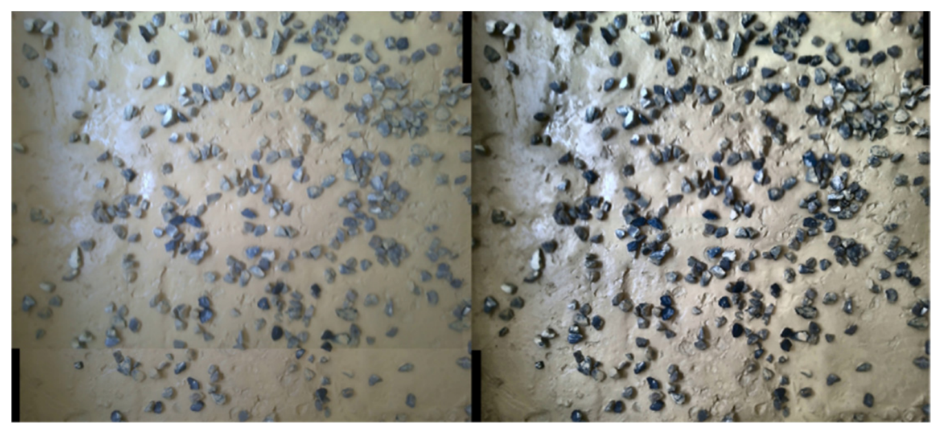
4.3. Comparative Analysis of Underwater Image Enhancement Effects
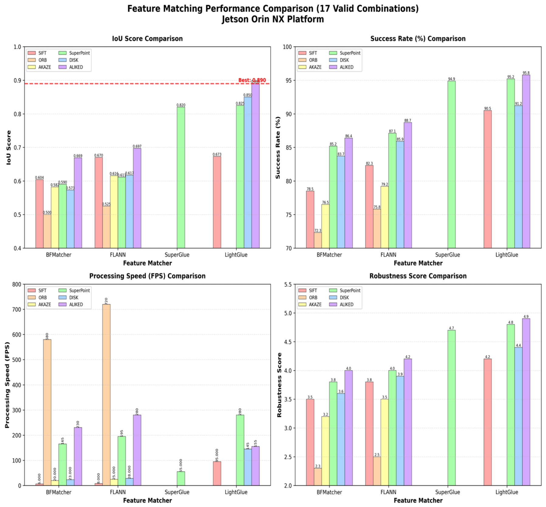
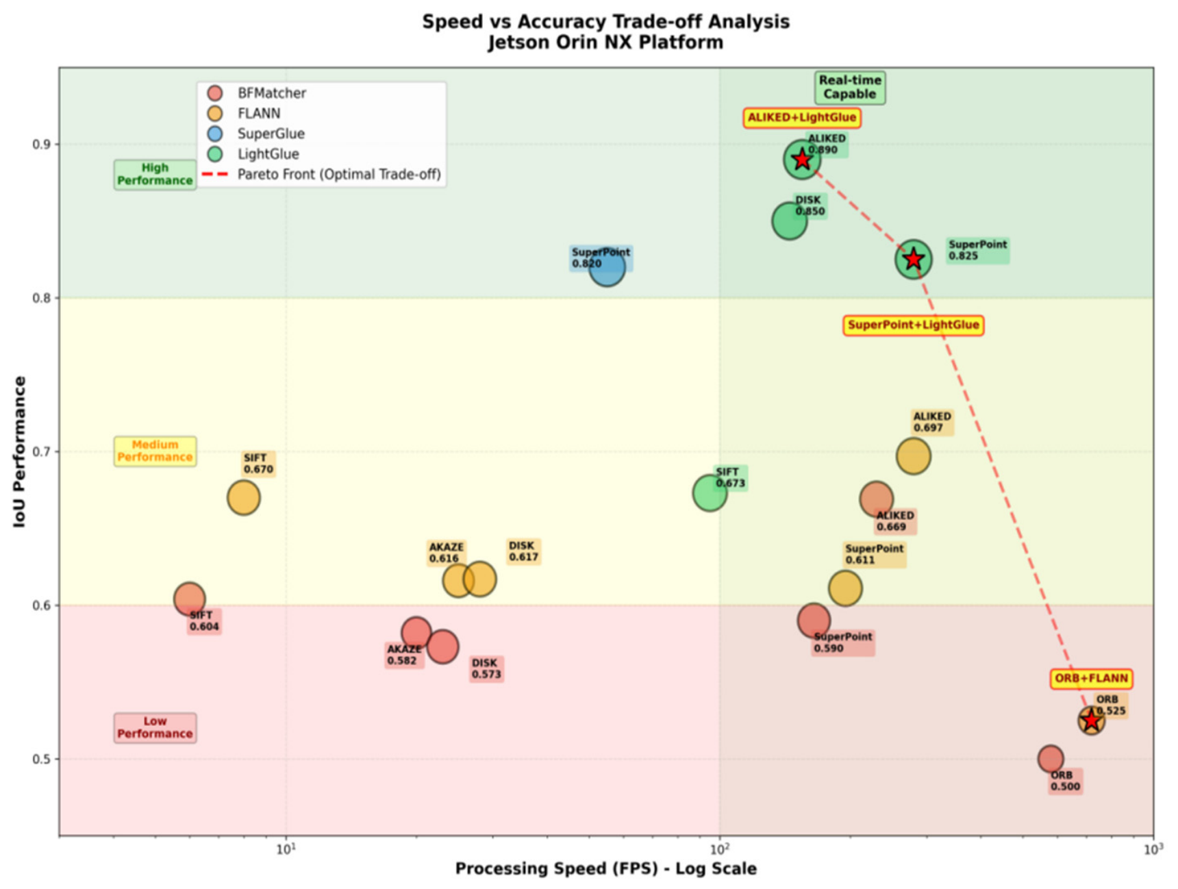
4.4. Comparison of Feature Extraction and Matching Algorithms
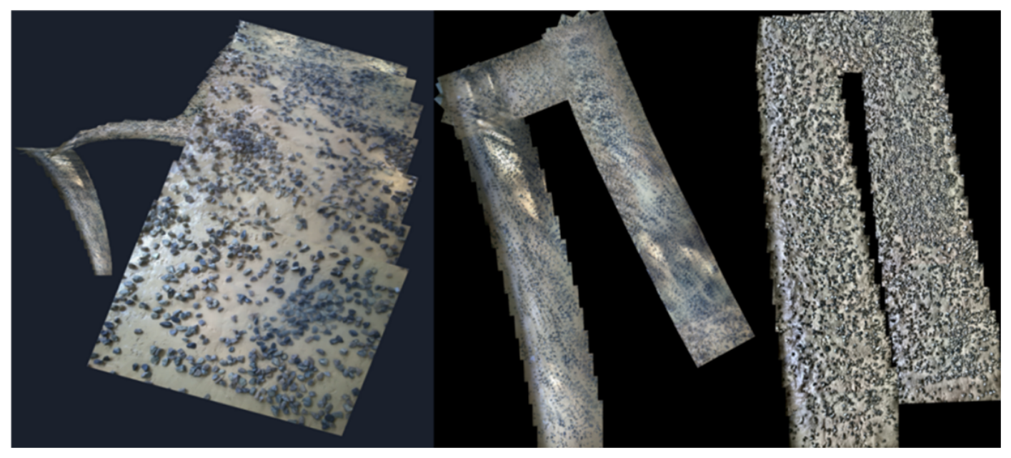
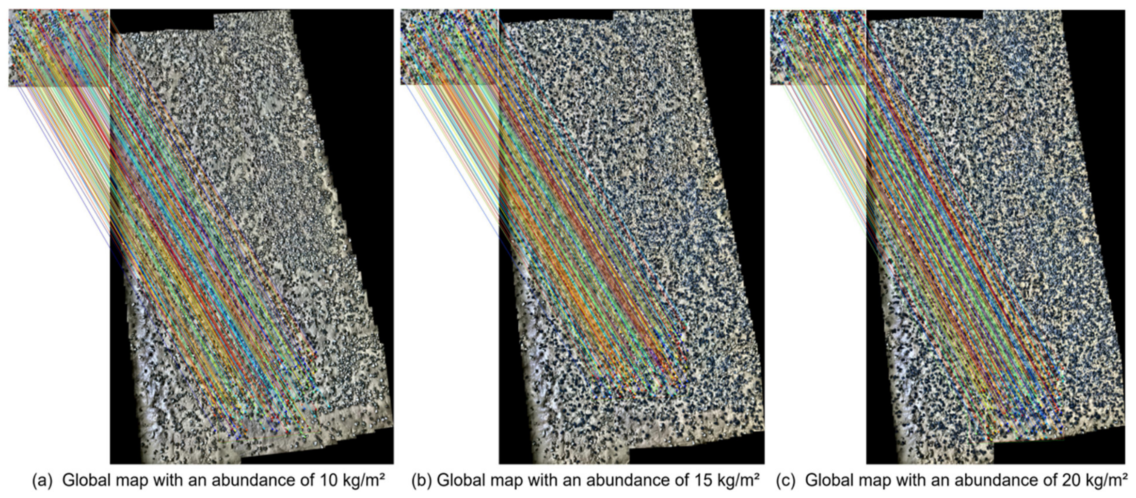
4.5. Global Mapping Accuracy and Drift Correction Analysis
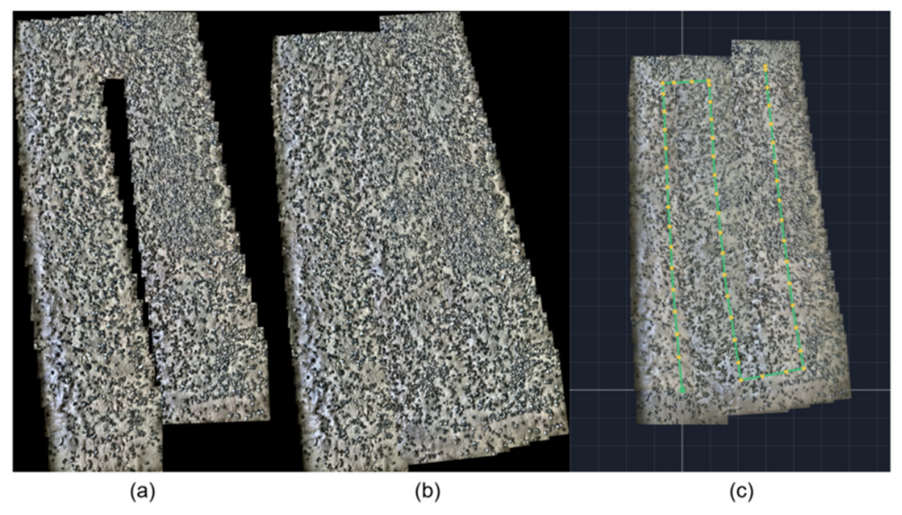
4.6. Motion Trajectory Recovery and Analysis
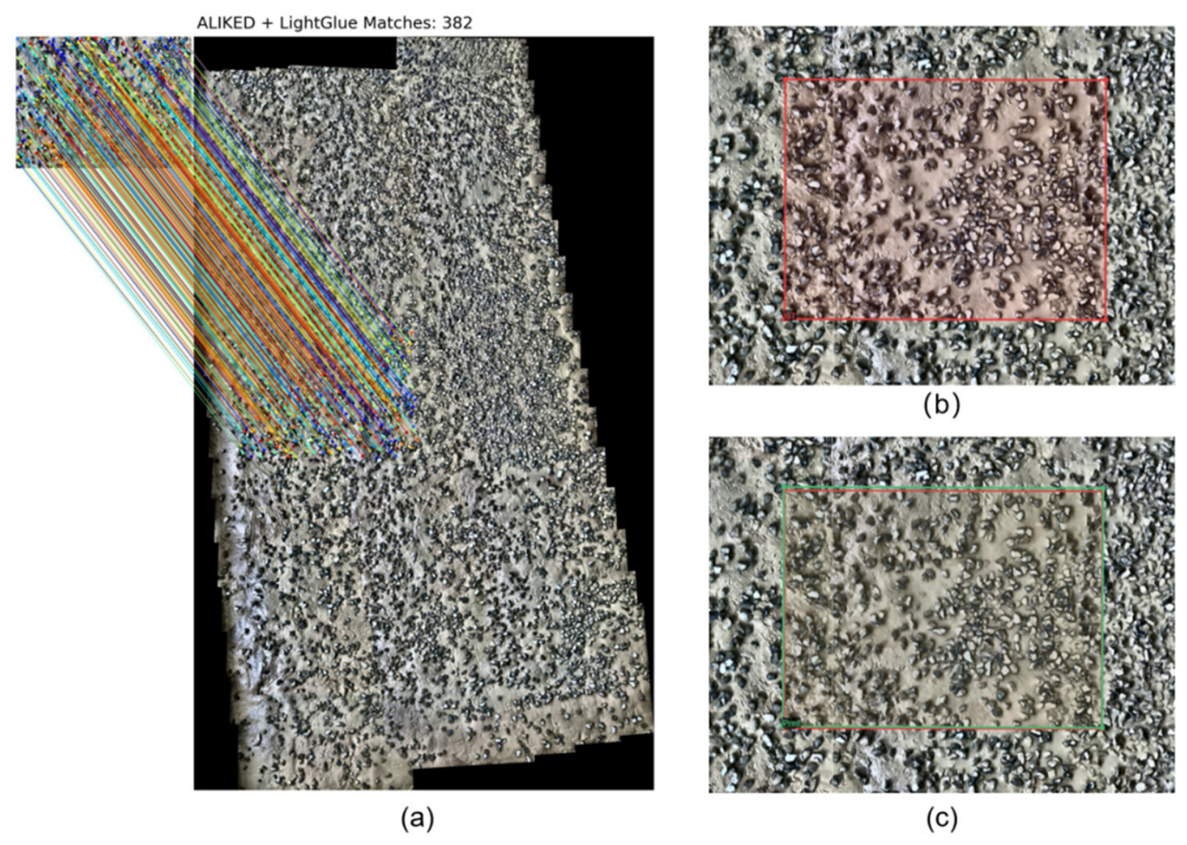
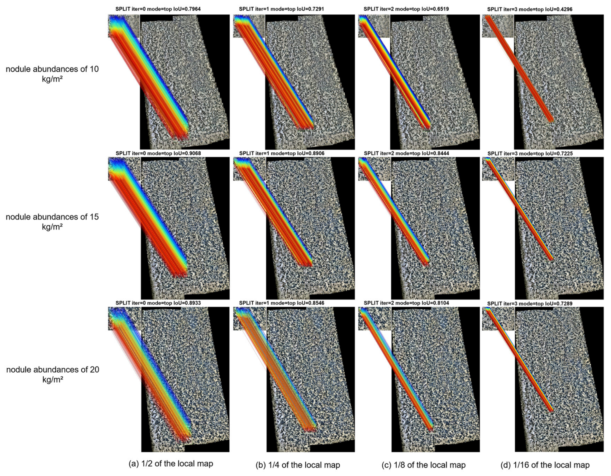
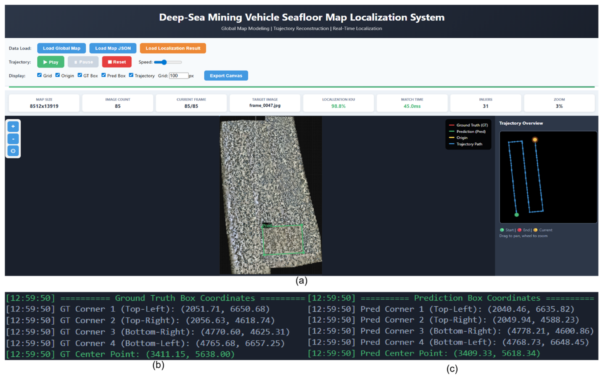
4.7. Local-to-Global Visual Localization Results
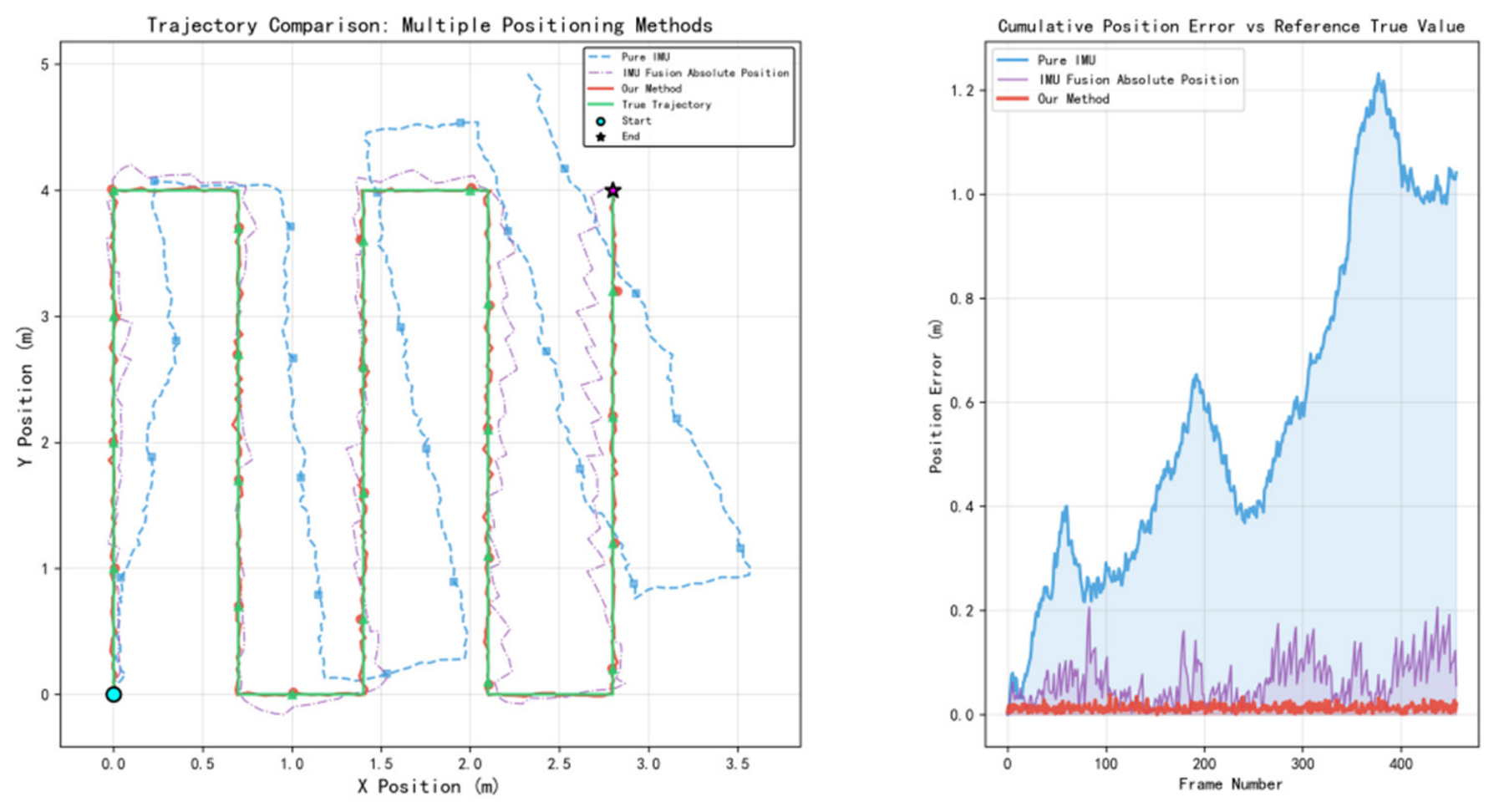
4.8. Precision Comparison Analysis with Traditional Localization Methods
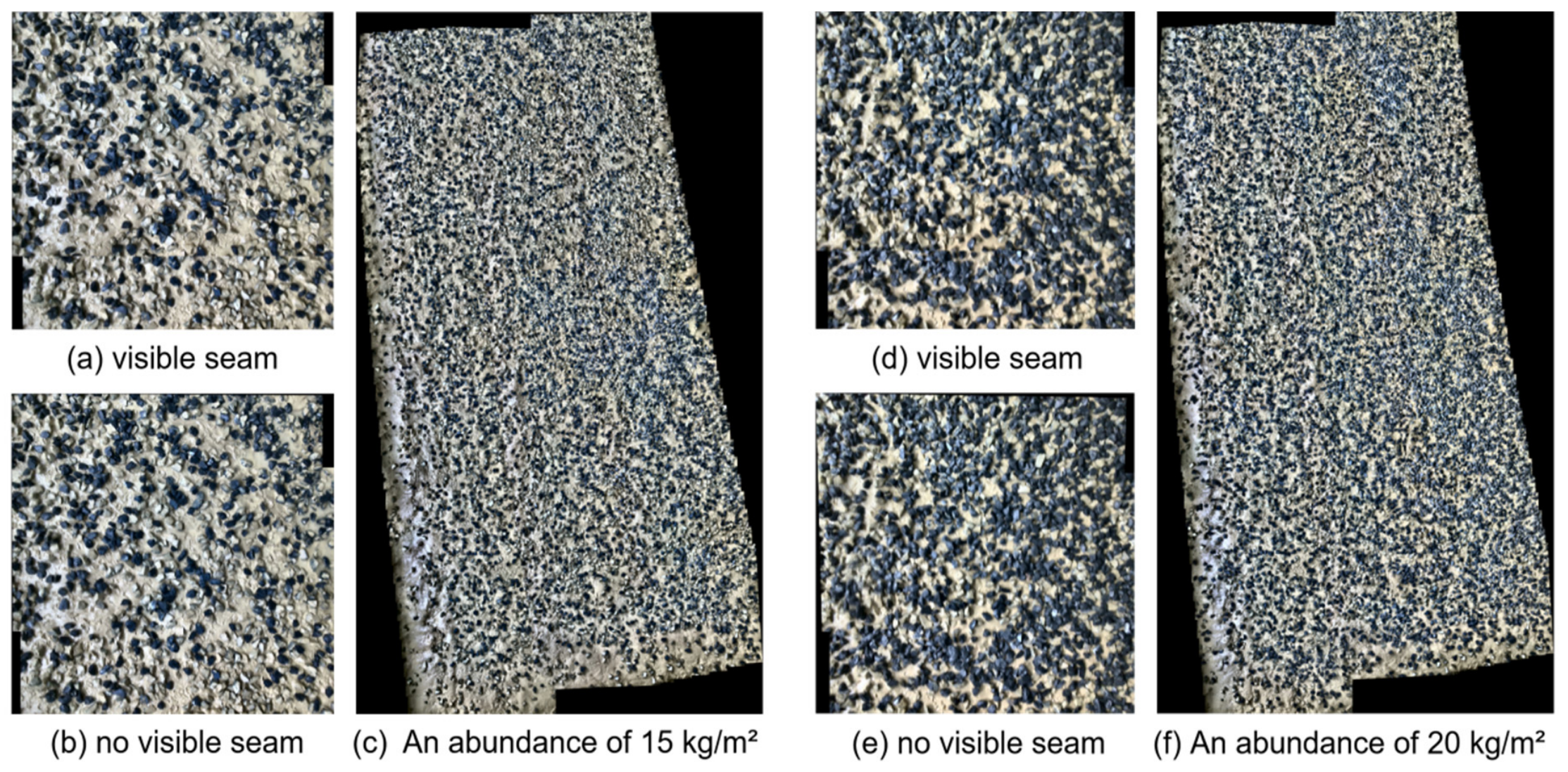
4.9. Experimental Validation Based on Simulated Deep-Sea Mining Scenario Datasets
4.10. Discussion
5. Conclusions and Future Work
5.1. Conclusions
5.2. Future Work
- (1)
- Deep Multi-Sensor Fusion: While visual localization shows clear advantages in specific scenarios, it is constrained by underwater visibility. Future work considers deeper-level information fusion of visual data with acoustic sensors (e.g., DVL, imaging sonar), inertial measurement units, and other sensors (e.g., magnetometers, depth sensors). By designing loosely or tightly coupled fusion architectures that leverage the complementary nature of multi-source information, it is expected to further enhance the system’s continuous positioning capability, robustness, and accuracy in extremely harsh environments, such as areas with very high turbidity or completely texture-less regions.
- (2)
- System Long-term Operation and Large-scale Mapping Optimization: To meet the requirements for long-term autonomous operations in larger-scale mining areas in the future, challenges need to be addressed. These include online incremental mapping, management and storage of large-scale maps, map updating and maintenance during long-term operation (to cope with environmental changes), and further optimization of algorithmic computational efficiency. Concurrently, researching more lightweight models and more efficient matching strategies to adapt to lower-power embedded platforms is of great significance for promoting the practical engineering application of this technology.
- (3)
- Regarding turbidity: under severe turbidity where the scattering coefficient substantially exceeds the absorption coefficient, the MSR illumination estimate becomes unreliable and feature descriptor quality degrades, consistent with the sensitivity observed in the UIEB severely-degraded subset (Table 3). Regarding seabed texture density: Table 4 shows that when the local map area ratio falls below 0.76% of the global map, the system fails to achieve reliable localisation (IoU < 0.5) even at the highest nodule abundance tested (20 kg/m2); in largely featureless sediment plains below 10 kg/m2, dead-reckoning bridging or acoustic aiding would be required. Regarding map-to-query appearance change: significant seabed disturbance between map construction and vehicle deployment may degrade localisation reliability; periodic map updates would be required in long-term commercial operations. Regarding illumination failure: complete illumination loss is a hard operational constraint not addressed by the present system.
Author Contributions
Funding
Data Availability Statement
Conflicts of Interest
References
- Teague, J.; Allen, M.J.; Scott, T.B. The Potential of Low-Cost ROV for Use in Deep-Sea Mineral, Ore Prospecting and Monitoring. Ocean Eng. 2018, 147, 333–339. [Google Scholar] [CrossRef]
- Cheng, Y.; Dai, Y.; Zhang, Y.; Yang, C.; Liu, C.; Cheng, Y.; Dai, Y.; Zhang, Y.; Yang, C.; Liu, C. Status and Prospects of the Development of Deep-Sea Polymetallic Nodule-Collecting Technology. Sustainability 2023, 15, 4572. [Google Scholar] [CrossRef]
- Yang, J.; Liu, L.; Lyu, H.; Lin, Z. Deep-Sea Mining Equipment in China: Current Status and Prospect. Chin. J. Eng. Sci. 2020, 22, 1–9. [Google Scholar] [CrossRef]
- Du, K.; Xi, W.; Huang, S.; Zhou, J. Deep-Sea Mineral Resource Mining: A Historical Review, Developmental Progress, and Insights. Min. Metall. Explor. 2024, 41, 173–192. [Google Scholar] [CrossRef]
- Chen, W.; Shang, G.; Ji, A.; Zhou, C.; Wang, X.; Xu, C.; Li, Z.; Hu, K. An Overview on Visual SLAM: From Tradition to Semantic. Remote Sens. 2022, 14, 3010. [Google Scholar] [CrossRef]
- DeTone, D.; Malisiewicz, T.; Rabinovich, A. SuperPoint: Self-Supervised Interest Point Detection and Description. In Proceedings of the IEEE Conference on Computer Vision and Pattern Recognition (CVPR) Workshops, Salt Lake City, UT, USA, 18–22 June 2018. [Google Scholar]
- Lindenberger, P.; Sarlin, P.-E.; Pollefeys, M. LightGlue: Local Feature Matching at Light Speed. In Proceedings of the IEEE/CVF International Conference on Computer Vision (ICCV), Paris, France, 2–6 October 2023. [Google Scholar]
- Wang, Z.; Cheng, Q.; Mu, X. RU-SLAM: A Robust Deep-Learning Visual Simultaneous Localization and Mapping (SLAM) System for Weakly Textured Underwater Environments. Sensors 2024, 24, 1937. [Google Scholar] [CrossRef] [PubMed]
- Shen, Q.; Zhao, H.; Yan, W.; Wang, C.; Qin, T.; Yang, M. Cross-Modal Visual Relocalization in Prior LiDAR Maps Utilizing Intensity Textures. In Proceedings of the 2024 IEEE/RSJ International Conference on Intelligent Robots and Systems (IROS), Abu Dhabi, United Arab Emirates, 14–18 October 2024. [Google Scholar]
- Schoening, T.; Jones, D.O.B.; Greinert, J. Compact-Morphology-Based Poly-Metallic Nodule Delineation. Sci. Rep. 2017, 7, 13338. [Google Scholar] [CrossRef]
- Huang, L.; Wang, S.; Liu, W.; Sun, Y.; Li, Y.; Hong, X.; Xu, M.; Jiang, L.; Xu, F.; Li, Y.; et al. Real-Time Simulation for Deep-Sea Mining System with Sea Trial Validation. Ocean Eng. 2025, 342, 122751. [Google Scholar] [CrossRef]
- Zhang, S.; Zhao, S.; An, D.; Liu, J.; Wang, H.; Feng, Y.; Li, D.; Zhao, R. Visual SLAM for Underwater Vehicles: A Survey. Comput. Sci. Rev. 2022, 46, 100510. [Google Scholar] [CrossRef]
- Wang, C.; Shu, X.; Zhou, S.; Song, H.; He, Q. Embracing a New Era of Deep-Sea Mining: Research Progress and Prospects. Mar. Policy 2025, 180, 106778. [Google Scholar] [CrossRef]
- Yuan, P.; Fan, C.; Zhang, C. Deep-Sea Image Stitching: Using Multi-Channel Fusion and Improved AKAZE. IET Image Process. 2023, 17, 4061–4075. [Google Scholar] [CrossRef]
- Shortis, M. Calibration Techniques for Accurate Measurements by Underwater Camera Systems. Sensors 2015, 15, 30810–30826. [Google Scholar] [CrossRef]
- Karmakov, S.; Aliabadi, M.H.F. Deep Learning Approach to Impact Classification in Sensorized Panels Using Self-Attention. Sensors 2022, 22, 4370. [Google Scholar] [CrossRef]
- Xie, Y.; Wang, Q.; Chang, Y.; Zhang, X. Fast Target Recognition Based on Improved ORB Feature. Appl. Sci. 2022, 12, 786. [Google Scholar] [CrossRef]
- Barath, D. SupeRANSAC: One RANSAC to Rule Them All. arXiv 2025, arXiv:2506.04803. [Google Scholar] [CrossRef]
- Li, F.; Chen, Y.; Shi, Q.; Shi, G.; Yang, H.; Na, J. Improved Low-Light Image Feature Matching Algorithm Based on the SuperGlue Net Model. Remote Sens. 2025, 17, 905. [Google Scholar] [CrossRef]
- Qin, T.; Li, P.; Shen, S. VINS-Mono: A Robust and Versatile Monocular Visual-Inertial State Estimator. IEEE Trans. Robot. 2018, 34, 1004–1020. [Google Scholar] [CrossRef]
- Hao, Y.; Liu, J.; Liu, Y.; Liu, X.; Meng, Z.; Xing, F. Global Visual–Inertial Localization for Autonomous Vehicles with Pre-Built Map. Sensors 2023, 23, 4510. [Google Scholar] [CrossRef]
- Yabuuchi, K.; Wong, D.R.; Ishita, T.; Kitsukawa, Y.; Kato, S. Visual Localization for Autonomous Driving Using Pre-Built Point Cloud Maps. In Proceedings of the 2021 IEEE Intelligent Vehicles Symposium (IV), Nagoya, Japan, 11–17 July 2021; IEEE: Piscataway, NJ, USA, 2021; pp. 913–919. [Google Scholar]
- Xu, H.; Liu, H.; Huang, S.; Sun, Y. C2L-PR: Cross-Modal Camera-to-LiDAR Place Recognition via Modality Alignment and Orientation Voting. IEEE Trans. Intell. Veh. 2025, 10, 1128–1144. [Google Scholar] [CrossRef]
- Campos, C.; Elvira, R.; Rodriguez, J.J.G.; Montiel, J.M.M.; Tardos, J.D. ORB-SLAM3: An Accurate Open-Source Library for Visual, Visual–Inertial, and Multimap SLAM. IEEE Trans. Robot. 2021, 37, 1874–1890. [Google Scholar] [CrossRef]
- Alkendi, Y.; Seneviratne, L.; Zweiri, Y. State of the Art in Vision-Based Localization Techniques for Autonomous Navigation Systems. IEEE Access 2021, 9, 76847–76874. [Google Scholar] [CrossRef]
- Zhao, X.; Wu, X.; Miao, J.; Chen, W.; Chen, P.C.Y.; Li, Z. ALIKE: Accurate and Lightweight Keypoint Detection and Descriptor Extraction. IEEE Trans. Multimed. 2023, 25, 3101–3112. [Google Scholar] [CrossRef]
- Zhao, C.; Fan, B.; Hu, J.; Pan, Q.; Xu, Z. Homography-Based Camera Pose Estimation with Known Gravity Direction for UAV Navigation. Sci. China Inf. Sci. 2021, 64, 112204. [Google Scholar] [CrossRef]
- Lu, L.; Dai, F. A Unified Normalization Method for Homography Estimation Using Combined Point and Line Correspondences. Comput.-Aided Civ. Infrastruct. Eng. 2022, 37, 1010–1026. [Google Scholar] [CrossRef]
- Arandjelovic, R.; Gronat, P.; Torii, A.; Pajdla, T.; Sivic, J. NetVLAD: CNN Architecture for Weakly Supervised Place Recognition. IEEE Trans. Pattern Anal. Mach. Intell. 2018, 40, 1437–1451. [Google Scholar] [CrossRef] [PubMed]
- Jaffe, J.S. Computer Modeling and the Design of Optimal Underwater Imaging Systems. IEEE J. Ocean. Eng. 1990, 15, 101–111. [Google Scholar] [CrossRef]
- Schechner, Y.Y.; Karpel, N. Recovery of Underwater Visibility and Structure by Polarization Analysis. IEEE J. Ocean. Eng. 2005, 30, 570–587. [Google Scholar] [CrossRef]
- Quintana, J.; Garcia, R.; Neumann, L.; Campos, R.; Weiss, T.; Köser, K.; Mohrmann, J.; Greinert, J. Towards Automatic nnRecognition of Mining Targets Using an Autonomous Robot. In Proceedings of the OCEANS 2018 MTS/IEEE Charleston, Charleston, SC, USA, 22–25 October 2018; pp. 1–7. [Google Scholar]
- Ding, Y.; Yang, J.; Kukelova, Z. Homography Decomposition Revisited. Int. J. Comput. Vis. 2026, 134, 102. [Google Scholar] [CrossRef]
- Schönberger, J.; Larsson, V.; Pollefeys, M. Fixing the RANSAC Stopping Criterion. arXiv 2025, arXiv:2503.07829. [Google Scholar] [CrossRef]
- Wang, S. Domain adaptation using transformer models for automated detection of exterior cladding materials in street view images. Sci. Rep. 2026, 16, 2696. [Google Scholar] [CrossRef] [PubMed]
- Wang, S. Domain-adaptive faster R-CNN for non-PPE identification on construction sites from body-worn and general images. Sci. Rep. 2026, 16, 4793. [Google Scholar] [CrossRef] [PubMed]



| Dataset | Resolution | Type | Scenario | Number of Images/Frames |
|---|---|---|---|---|
| UIEB | Various | Images | Coral, Fish, Seabed Scenery | 890 |
| Severely Degraded Images | 60 | |||
| Nodule Abundance: 10 kg/m2 | 1800 | |||
| Video | Nodule Abundance: 15 kg/m2 | 1800 | ||
| Nodule Abundance: 20 kg/m2 | 1800 | |||
| Pacific Mining Area | 1920 × 1080 | Images | Polymetallic Nodule Area | 690 |
| Video |
| Methods | Frame Extraction | Compression Ratio | Utilization | Average Sharpness | Average Overlap Rate |
|---|---|---|---|---|---|
| Uniform sampling—30 fps | 52,384 | 0% | 45% | 285 | 92% |
| Uniform sampling—3 fps | 5238 | 90.0% | 68% | 290 | 72% |
| SIFT-based | 8381 | 84.0% | 72% | 310 | 78% |
| Clarity only | 7858 | 85.0% | 62% | 425 | 88% |
| Ours | 3127 | 94.0% | 88% | 385 | 76% |
| Method | No-Reference IQA Metrics | Full-Reference IQA Metrics | ||||
|---|---|---|---|---|---|---|
| UCIQE | UIQM | Entropy | Average Gradient | PSNR (dB) | SSIM | |
| RAW | 6.3527 | 0.2961 | 6.4463 | 14.4029 | - | - |
| DCP | 7.7151 | 0.5606 | 6.4965 | 19.6177 | 13.8413 | 0.9273 |
| CLAHE | 7.5657 | 0.8001 | 7.0049 | 24.0509 | 14.7681 | 0.8515 |
| Ours | 7.7796 | 1.7744 | 7.3671 | 43.3219 | 18.8413 | 0.7445 |
| Nodule Abundance (kg/m2) | Full Image | 1/2 of the Local Map | 1/4 of the Local Map | 1/8 of the Local Map | 1/16 of the Local Map | 1/32 of the Local Map |
|---|---|---|---|---|---|---|
| 10 kg/m2 | 0.9532 | 0.7964 | 0.7291 | 0.6519 | 0.4296 | - |
| 15 kg/m2 | 0.9701 | 0.9068 | 0.8906 | 0.8444 | 0.7225 | - |
| 20 kg/m2 | 0.9709 | 0.8993 | 0.8546 | 0.8104 | 0.7289 | - |
Disclaimer/Publisher’s Note: The statements, opinions and data contained in all publications are solely those of the individual author(s) and contributor(s) and not of MDPI and/or the editor(s). MDPI and/or the editor(s) disclaim responsibility for any injury to people or property resulting from any ideas, methods, instructions or products referred to in the content. |
© 2026 by the authors. Licensee MDPI, Basel, Switzerland. This article is an open access article distributed under the terms and conditions of the Creative Commons Attribution (CC BY) license.
Share and Cite
Cheng, Y.; Wang, B.; Zhuo, X.; Liu, K.; Guan, Y. Visual Localization for Deep-Sea Mining Vehicles During Operation. J. Mar. Sci. Eng. 2026, 14, 759. https://doi.org/10.3390/jmse14080759
Cheng Y, Wang B, Zhuo X, Liu K, Guan Y. Visual Localization for Deep-Sea Mining Vehicles During Operation. Journal of Marine Science and Engineering. 2026; 14(8):759. https://doi.org/10.3390/jmse14080759
Chicago/Turabian StyleCheng, Yangrui, Bingkun Wang, Xiaojun Zhuo, Kai Liu, and Yingjie Guan. 2026. "Visual Localization for Deep-Sea Mining Vehicles During Operation" Journal of Marine Science and Engineering 14, no. 8: 759. https://doi.org/10.3390/jmse14080759
APA StyleCheng, Y., Wang, B., Zhuo, X., Liu, K., & Guan, Y. (2026). Visual Localization for Deep-Sea Mining Vehicles During Operation. Journal of Marine Science and Engineering, 14(8), 759. https://doi.org/10.3390/jmse14080759