Article

Pearl River Estuary Shelf Elements Reveal Asynchronous Enhanced Human Activities During Late Holocene in South China


1
South China Sea Survey Center, Ministry of Natural Resources, Guangzhou 510300, China
2
Key Laboratory of Marine Environmental Survey Technology and Application, Ministry of Natural Resources, Guangzhou 510300, China
3
School of Geography, South China Normal University, Guangzhou 510631, China
4
School of Geography, Lingnan Normal University, Zhanjiang 524048, China
*
Author to whom correspondence should be addressed.
J. Mar. Sci. Eng. 2026, 14(5), 467; https://doi.org/10.3390/jmse14050467
Submission received: 29 December 2025 / Revised: 11 February 2026 / Accepted: 21 February 2026 / Published: 28 February 2026
(This article belongs to the Section Geological Oceanography)

Abstract

Human-driven soil erosion is a signal of the widely debated “Anthropocene”. There is widespread controversy regarding the time consistency and time transgression of human-driven soil erosion in the Late Holocene. In this study, three well-dated cores, B10, B14 and W20 from west to east, spanning the past 4–6 ka from the Pearl River Estuary (PRE) shelf, southern China, were selected for elemental tests. Principal component analysis divides the elements into four components. The first principal component (PC1) includes TFe2O3, Al2O3, V, Cs, Rb, Ga, TiO2, K2O, Ta, Nb, MnO, Th, LOI, and Cl, being the proxy for fine-grained terrigenous input and watershed soil erosion. The PC1 variations in B10 and B14 reveal that erosion enhanced at ~2.2 ka BP, and less erosion occurred at ~1.5 ka BP but has intensified since ~1.2 ka BP, which is consistent with the simulated cropland area of the Pearl River Basin and lake records in the upper West River, southwestern China. However, the records from the W20 reveal a continuous increase in terrestrial input since 2.2 ka BP, which is consistent with the soil erosion changes recorded by the South China coast lakes at its provenance region. Hence, differences in the initial age of the signals of human activities were revealed in the PRE shelf system. Our study not only reveals the time transgression of the “Anthropocene” boundary but also updates the sediment source-to-sink model of the PRE shelf system.

1. Introduction

The “Anthropocene” was proposed at the beginning of this century, aiming to establish a global stratigraphic unit for the human-dominated environmental changes [1] and denoting a dramatic, ongoing, planetary shift from prolonged relative Holocene stability [2]. However, the Anthropocene is a controversial geological epoch and has been widely discussed in recent decades [1,2,3,4,5,6,7]. Although the mainstream view holds that the Anthropocene commenced at ~1950 AD [8], there are still views suggesting that the Holocene is the beginning of Anthropocene [9,10]. Archaeological and geological records indicate that, since the Holocene, human settlements and agriculture activities have induced deforestation and soil erosion on the Earth’s surface [11,12,13]. Some studies have argued that this represents the key evidence distinguishing the Holocene from the Anthropocene [5,14]. Currently, there are two prevailing viewpoints regarding anthropogenic soil erosion on a global scale. One holds that the extensive human-driven soil erosion began in the middle Holocene based on the statistical unified timeline of accelerated sedimentation accumulation rates in lakes worldwide [12] or nationally [15]. The other suggests the time transgressive signals of human-induced soil erosion in different regions within a country based on the different ages of accelerated sediment massive accumulation rates in lakes in Britain, Ireland [16], and China [17].
Estuary shelf systems are critical sedimentary archives, recording the variable terrestrial input related to nature and human-induced soil erosion [18,19]. The Late Holocene (~4 ka BP) witnessed the rapid infilling of many large river deltas [20,21] and adjacent inner shelves [22], a process facilitated by mild climatic conditions but significantly accelerated by intensifying human activities, which enhanced sediment supply [20,23]. However, few studies have sought to find synchronous or asynchronous records of enhanced human-driven erosion in the sediment in continental shelf areas, because most studies have treated the watershed as a single system without dissecting its internal sediment supply.
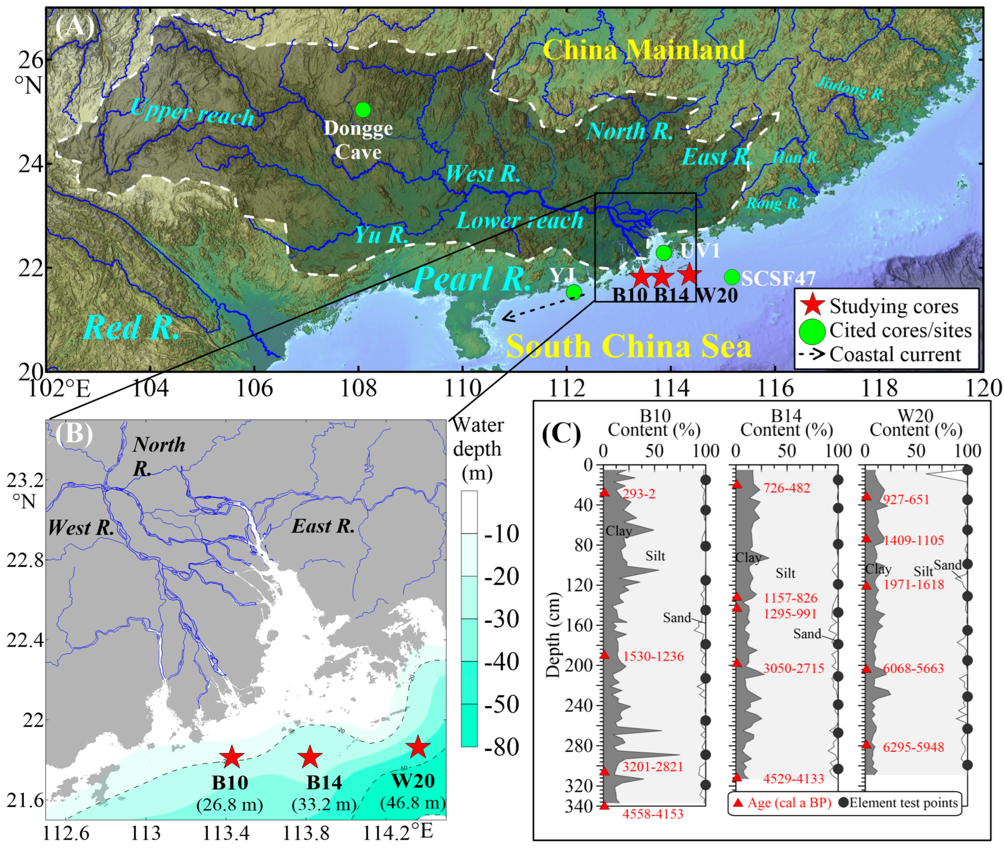
The Pearl River Estuary (PRE) in southern China is ideal for covering the above-mentioned gap due to the following two reasons: First, the PRE formed primarily by sediment discharge from the West, North, and East Rivers (Figure 1A). The historical and lake sediment records indicate that human-induced soil erosion occurred first in the South China coast and then spread landward to the upper West River, showing a clear asynchronous “Anthropocene” pattern [17]. Moreover, although there was controversy over whether the sediment sources in the PRE shelf system were affected by external sediment [24], it has now been confirmed that the sediment within the sedimentary system mainly came from the inner Pearl River [25,26]. Therefore, the PRE shelf sedimentary system may have preserved the “Anthropocene” sedimentary records from the Pearl River Basin. Previous studies focused on the rapidly human-driven Pearl River Delta development pattern [21,27] and human activity signals (e.g., magnetic susceptibility, chemical weathering indexes, heavy metals, and pollen and charcoal concentration) recorded in the sediment cores of the UV1 [28], YJ [29], and SCSF47 [30] (Figure 1A). Some of the commonly used indicators of human activities do not vary synchronously; their increasing or decreasing trends are mainly identified by visual inspection of the indicator–time series curves. Therefore, more cores are needed to accurately interpret the signals of human activities and PRE shelf system evolution.
In this study, three well-dated cores located in the west, middle and east sides of the PRE (Figure 1) [31] were used for elemental tests, extracting the watershed soil erosion proxy, and reconstructing the soil erosion history. Our central hypothesis is that the timing of the intensified human activities recorded in the sediment cores from the eastern and western Pearl River Estuary shelf is asynchronous, due to spatial differences in human activities within the different sub-basins of the Pearl River watershed. This asynchronous pattern has not yet been documented in previous studies.
Figure 1. (A) Study area with locations of study cores B10, B14, and W20; cited cores/sites of Dongge Cave [32]; and cores UV1 [28], YJ [29], and SCSF47 [30]. (B) The Pearl River Estuary (PRE)–northern South China Sea (SCS) system and study core locations. (C) Down-core grain size compositions, accelerator mass spectrometry (AMS)14C ages in red [31], and the element test points for 3 studied cores. Water depths for cores are illustrated in (B).
Jmse 14 00467 g001

2. Materials and Methods

2.1. Regional Settings

The Pearl River Estuary (PRE)–northern South China Sea (SCS) system constitutes a critical repository of Holocene sedimentary records, ideal for reconstructing paleoenvironmental evolution. The Pearl River, the primary sediment source, is a composite system comprising the West (Xijiang), North (Beijiang), and East (Dongjiang) Rivers, which converge into the PRE (Figure 1A). Geologically, its catchment in southern China is characterized by a complex assemblage of Mesozoic granitic rocks (predominantly from the Cretaceous and Jurassic), Paleozoic to Mesozoic carbonates (Devonian to Triassic), and Cenozoic sedimentary rocks. This geological framework underpins a diverse geomorphology, where mountainous and hilly terrain prevails. The northwestern Yunnan–Guizhou Plateau (average elevation: 1000–2000 m), featuring intermontane basins and lakes, contrasts the lower-lying hills (~500 m) in the east. Climatically, the basin experiences a subtropical to tropical maritime monsoon climate [33], with a modern mean annual temperature of ~22 °C and abundant annual precipitation (1600–2000 mm), over 80% of which falls during the spring and summer, creating distinct seasonal contrasts between warm, humid summers and cool, dry winters [34].
Since the Middle Holocene with its relatively stable sea level, the sediments on the shelf adjacent to the PRE have been dominated by mud derived from the Pearl River, alongside relict sands from the Late Pleistocene [22,35]. This mud deposit forms a contiguous belt extending from the PRE westward, primarily confined to water depths shallower than 90 m [36]. The PRE shelf system has been governed by high sediment discharge from the river and its subsequent westward transport by the coastal current system since 7 ka BP (Figure 1A). Since that time, the sea level has been relatively stable, with a fluctuation of about ±5 m [36]. Human activities during recent millennia have played a significant role in influencing the mud deposition on the PRE shelf system [22,25,28,29].

2.2. Core Locations and Sedimentology

The 3 cores (west: B10, middle: B14 and east: W20) were collected using a gravity corer during a 2022 cruise by the South China Sea Survey Center, Ministry of Natural Resources (Figure 1). The western sites (B10 and B14), situated closer to the paleo-delta complex and main river mouth, directly record the erosional history of the Pearl River Basin, particularly that of the West River. Meanwhile, the eastern site’s W20 record captures a more integrated signal from smaller coastal river materials. The age framework, lithological description, and grain size characteristics have been reported [31]. In short, the 3 cores cover the past 4 to 6 thousand years (ka) and are mainly composed of clayey silt (Figure 1C). For each core, 10 samples were collected at intervals of ~20–30 cm for element tests. This sampling strategy ensured an appropriate stratigraphic resolution for identifying the sedimentary record of human activities. The layer positions of the selected samples are marked in Figure 1C.

2.3. Elemental Geochemistry

Samples for major and trace element analysis were dried at low temperature and then ground to a particle size of less than 200 mesh (a particle size of <0.075 mm or ≈4 φ).
Two steps were used for major element tests. First, the loss on ignition (LOI) was analyzed using the gravimetric method, which involved weighing the sample at 1000 °C until a constant weight was achieved, and the difference in weight during the heating process was defined as the LOI. Second, the major element compositions were determined by X-ray fluorescence (XRF) spectrometry (PANalytical PW5400). The aliquot was thoroughly mixed with a lithium borate–lithium nitrate flux containing LiNO3 and fused at high temperature. The melt was cast into a platinum mold to form a flat glass disc for XRF analysis. Elements Al, Ca, Cl, Fe, K, Mg, Mn, Na, P, Si, S, Ti were measured, and all except Cl are shown in the form of oxides. The analytical total (“total”) for this method was calculated as the sum of the LOI and the elemental oxide concentrations obtained from XRF. Meanwhile, 2 standard samples (GBW07105 and NCSDC47009 for elements and AMIS0185 and GBW07121 for LOI), 2 duplicate samples (B14–147 cm and W20–131 cm), and 1 blank sample were added for testing to serve as a comparison. The relative deviation (RD) and relative error (RE) for the major elements and LOI tests were all <5%.
To test the trace elements, the measured sample was mixed with a lithium borate flux (LiBO2/Li2B4O7), homogenized, and fused in a furnace at 1025 °C. After cooling, the fused bead was digested with a mixture of nitric, hydrochloric, and hydrofluoric acids, followed by volumetric dilution. The resulting solution was then analyzed by inductively coupled plasma mass spectrometry (ICP-MS, Agilent 7900), and the concentrations of Ba, Cs, Ga, Hf, Nb, Rb, Sr, Ta, Th, U, V, Y, and Zr were thus obtained. Meanwhile, 4 standard samples (MRGeo08, OREAS-100a, OREAS-120 and SY-5), 2 duplicate samples (B14–267 cm and W20–263 cm), and 2 blank samples were added for testing to serve as a comparison. The RD and RE values were <10% for all tested trace elements.

2.4. Extraction of Watershed Soil Erosion Proxy

The watershed soil erosion proxy is a comprehensive proxy reflecting the erosion throughout the entire basin and its input into the continental shelf area. It is not affected by marine organisms or autochthonous processes. To extract the proxy, Spearman’s correlations for all measured elements were calculated and plotted using an online tool (https://www.chiplot.online/correlation_heatmap.html (accessed on 1 February 2026)), and principal component analysis (PCA) was applied [37,38]. The PCA for the elements was performed by using IBM SPSS Statistics 19 software. Kaiser–Meyer–Olkin (KMO) and Bartlett’s tests were carried out to examine the suitability of the data for PCA. The KMO is expressed as a proportion of variance (common variance) and used to measure the reliability of sampling. Generally, a high KMO value implies the suitability of the data for PCA. Bartlett’s test of sphericity indicates whether the correlation matrix is an identity matrix and points to the variables not specified in the confidence intervals. The significance level <0.05 indicates a significant relationship among the variables. The eigenvector and eigenvalues are extracted from the covariance matrix of the original variables. The eigenvalues and loadings of the PCs are the measures of their associated variance and the participation of the original variables in the PCs, respectively. The coordinates of the objects are defined as scores. PCs are sorted in descending order from high to low, e.g., the first PC (PC1) and second PC (PC2).

3. Results

3.1. Elemental Results

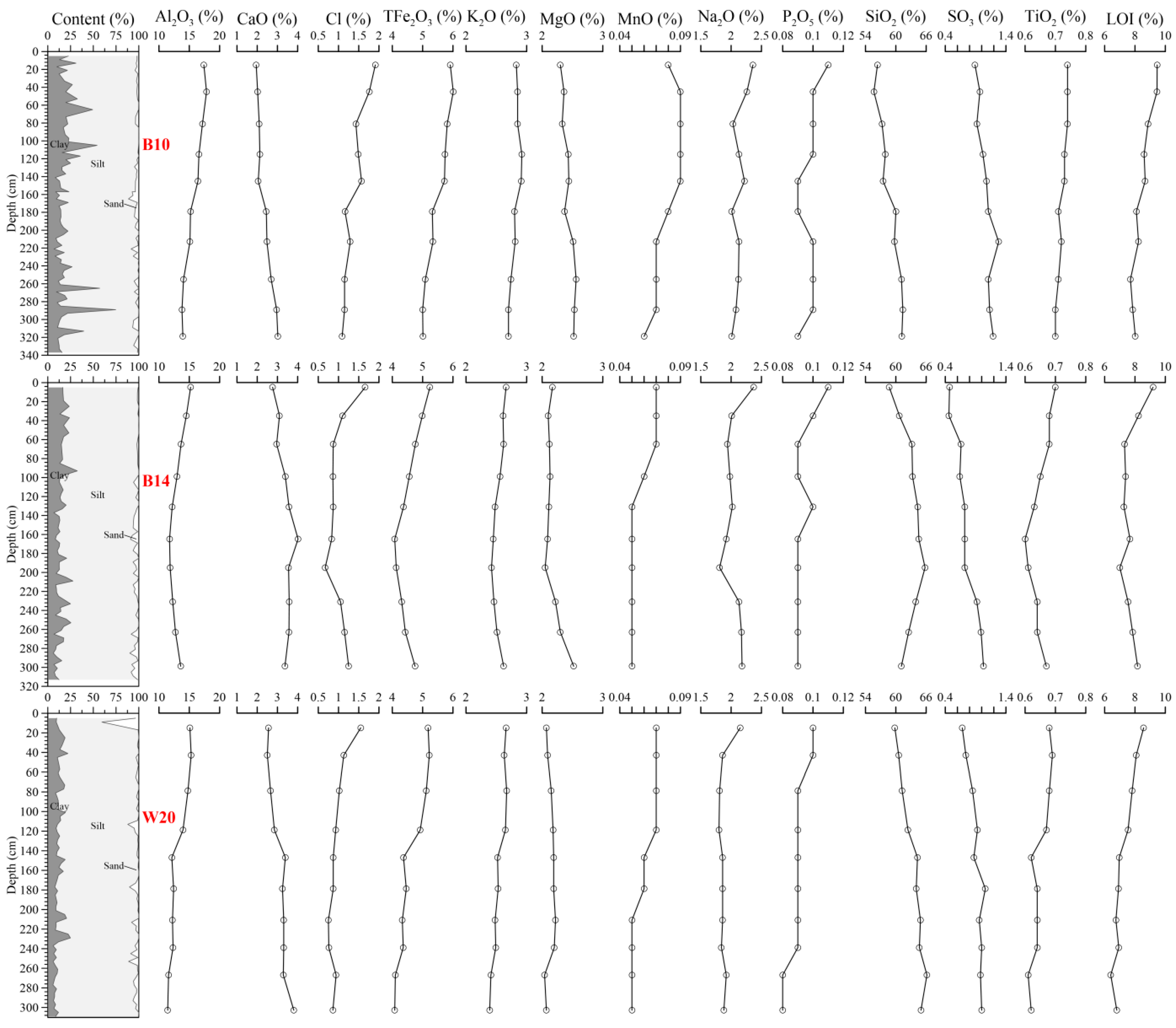
According to the down-core elemental profiles of cores B10, B14, W20, the major element compositions exhibit consistent ranges with clear down-core variations (Table S1, Figure 2). SiO2 and Al2O3 are the dominant components, with concentrations ranging from 54–66% and 10–20%, respectively. TFe2O3 (Total Fe2O3) contents vary between 4% and 6%, while CaO and K2O show moderate levels of 1–4% and 2–3%, respectively. Notably, MgO (2–3%) and Na2O (1.5–2.5%) display relatively stable profiles for the three cores. In contrast, elements such as Cl (0.5–2%), SO3 (0.4–1.4%), and P2O5 (~0.08–0.12%) occur in notably lower abundances. The LOI varies from 6 to 10%, indicating a moderate and variable content of volatile phases. Notably, the contents of Al2O3, Cl, TFe2O3, K2O, MnO, Na2O, P2O5, TiO2, and LOI show a consistent increasing trend upward (i.e., decreasing with sediment depth) in all three cores (B10, B14, and W20). In contrast, the concentrations of CaO, SiO2, and SO3 display a consistent decreasing trend upward (i.e., increasing with sediment depth) across the three studied cores. Only the down-core variations in MgO differ among the three cores (Figure 2).
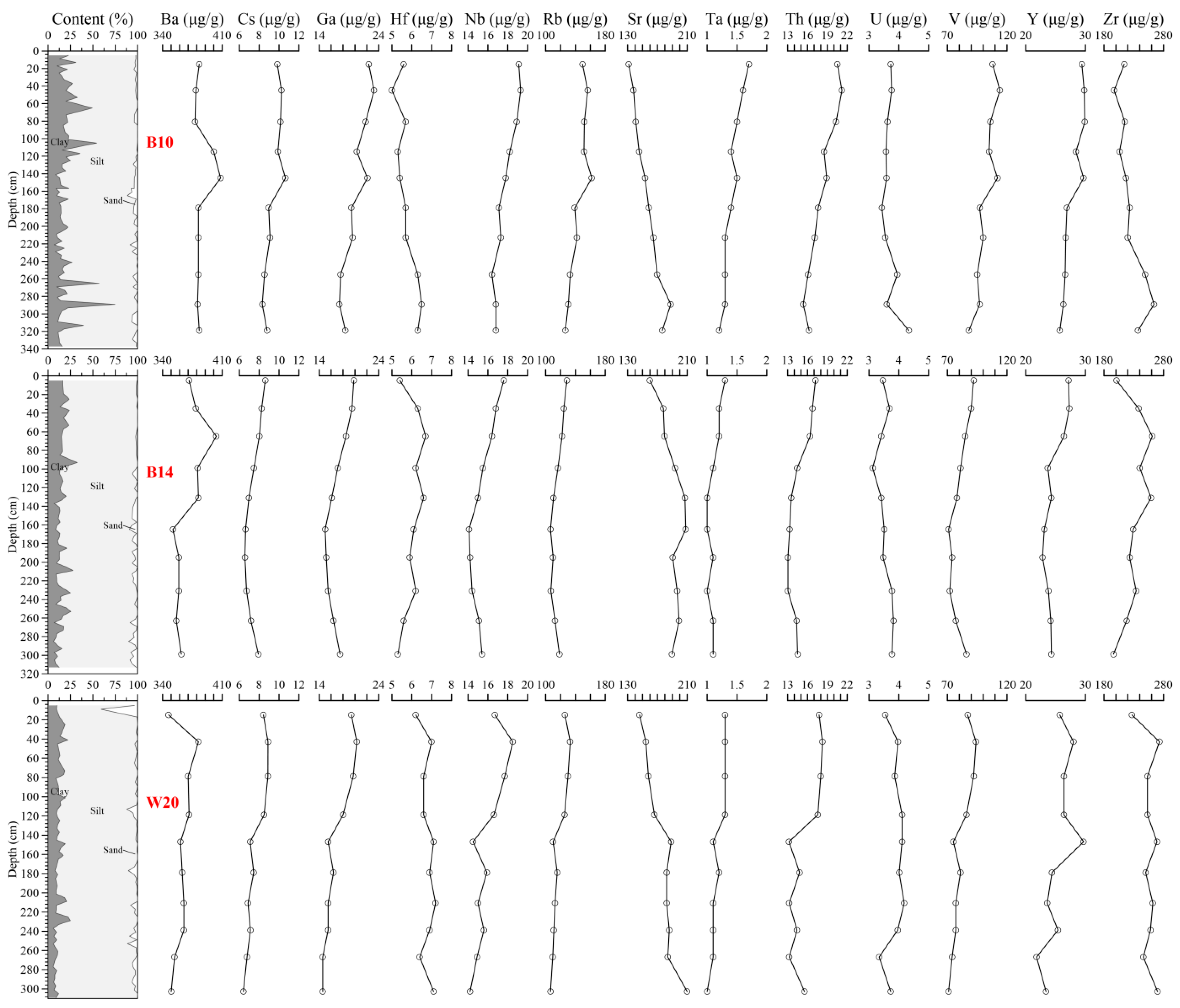
The trace elements display distinct concentration ranges and down-core distribution patterns across the three cores (Table S2, Figure 3). Ba (340–410 μg/g), Rb (100–180 μg/g), Sr (130–210 μg/g), V (70–120 μg/g), and Zr (180–280 μg/g) are present in relatively high concentrations, while Cs (6–12 μg/g), Hf (5–8 μg/g), Ta (1–2 μg/g), and U (3–5 μg/g) occur at much lower levels. Several elements, including Nb (14–20 μg/g), Ga (14–24 μg/g), Th (13–22 μg/g), and Y (20–30 μg/g), show moderate abundances. Regarding vertical trends, elements such as Rb, V, and Y exhibit broadly similar patterns of variation with depth in all three cores. U concentrations remain consistently low, with minimal variation throughout the profiles. Notably, the contents of Cs, Ga, Nb, Rb, Ta, Th, and V show an increasing trend upward (Figure 2).

3.2. Correlation Results of Elements

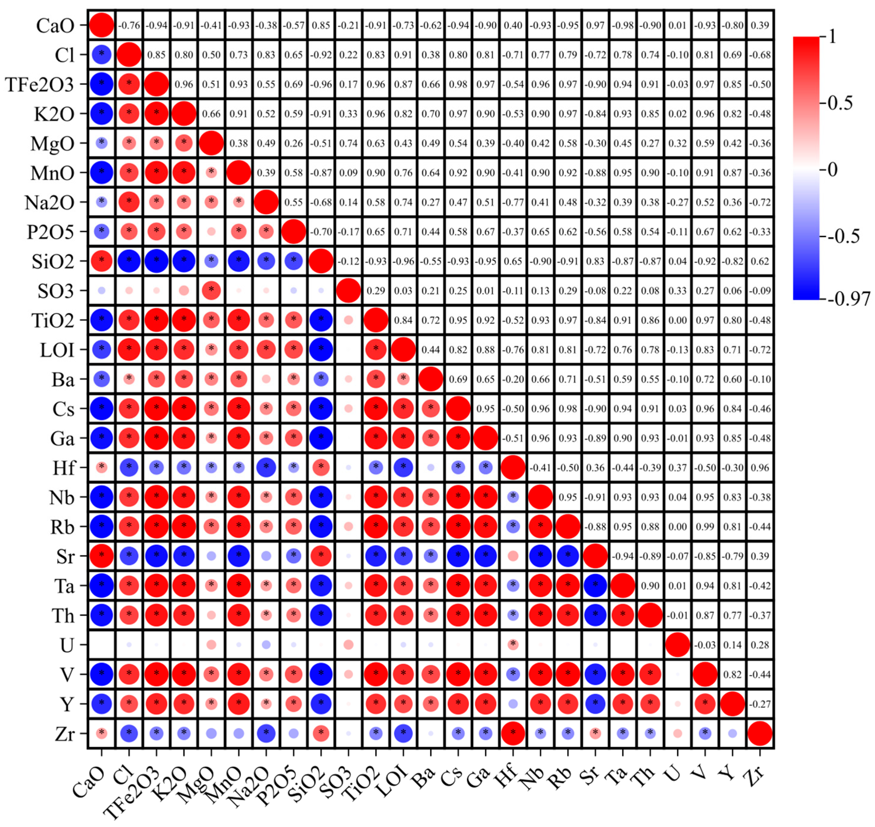
Based on the correlation analysis of the elemental compositions (Figure 4), distinct geochemical associations are identified. A strong, coherent geochemical signature is observed among a suite of major and trace lithogenic elements (i.e., terrigenous elements derived from bedrock weathering and soil erosion in the drainage basin). Specifically, CaO, TFe2O3, TiO2, LOI, Cs, Ga, Nb, Rb, and V show very strong positive mutual correlations (r > 0.90). Key major oxides, such as SiO2 and K2O, also exhibit strong positive correlations (r > 0.80) with this group. In contrast, a distinct cluster of trace elements demonstrates markedly different behavior. Elements including Hf, Sr, and Ta are characterized by moderate to strong negative correlations with the lithogenic elements; for instance, Sr shows strong negative correlations with Nb (r = −0.93) and Rb (r = −0.90). Meanwhile, U displays consistently weak correlations (|r| < 0.31) with nearly all other elements, suggesting an independent control of its distribution in the sediments. Furthermore, components often influenced by secondary processes (i.e., post-depositional early diagenesis, pore-water geochemical reactions and authigenic mineral formation), such as Cl, SO3, and to a lesser extent MgO and Na2O, show moderate positive inter-correlations (r = 0.40–0.70). Notably, P2O5 and MnO show predominantly weak to moderate correlations (|r| typically < 0.70) with most other elements.

3.3. PCA Results

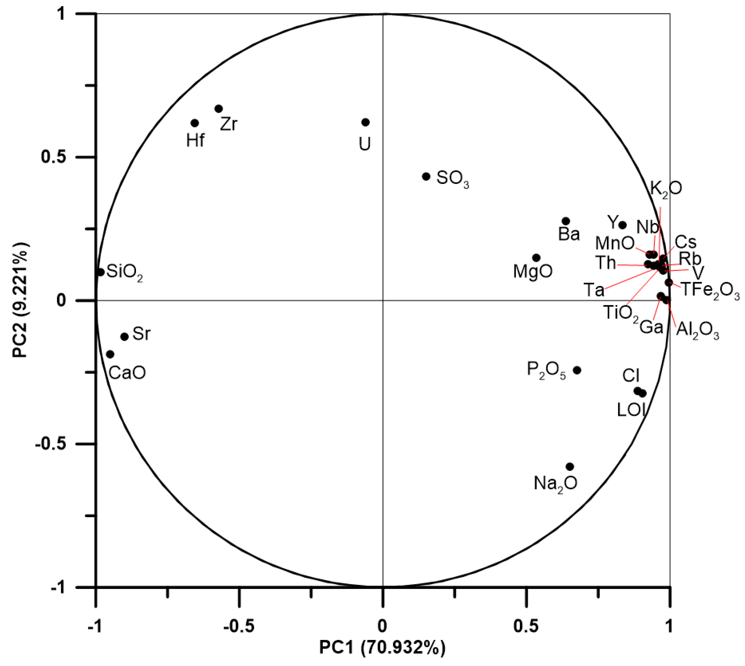
The results of the PCA for the measured elements are presented in Table 1 and Figure 5. The first four PCs together explain 91.59% of the total variance in the dataset. PC1 accounts for 70.93% of the variance and is strongly positively loaded (>0.90) by TFe2O3, Al2O3, V, Cs, Rb, Ga, TiO2, K2O, Ta, Nb, MnO, Th, LOI, and Cl. In contrast, SiO2 and CaO show strong negative loadings (approximately −0.98 and −0.95, respectively) on PC1. PC2 explains 9.22% of the variance and is characterized by moderate to high positive loadings from Hf (0.62), Zr (0.67), and U (0.62). PC3, explaining 7.35% of the variance, is dominated by high positive loadings from SO3 (0.83) and MgO (0.77). PC4 accounts for 4.09% of the variance, with U (0.68) and a negative loading from Ba (−0.55) being its most distinct features.

4. Discussion

4.1. PC1 as the Proxy of Fine-Grained Terrigenous Input and Watershed Soil Erosion

PC1 is strongly positively loaded by elements indicative of clay minerals and weathered clastic materials, such as Al2O3, K2O, Rb, and TFe2O3, while showing strong negative loadings for SiO2 and CaO. This inverse pattern probably reflects the dilution effect of coarse quartz and biogenic debris on fine-grained terrigenous materials [37,39]. Here, quartz sand represents the relatively coarse terrigenous clastic component supplied by the Pearl River, while biogenic carbonate is mainly derived from in situ marine organisms (e.g., foraminifera) in the shelf/prodeltaic setting. The increased supply of fine-grained weathered material from the Pearl River catchment is thus inversely correlated with the relative abundance of quartz sand and biogenic carbonate. Studies on the entire sediment of the SCS have also shown that, in the areas from the estuary to shelf, the terrigenous sediment input (mainly composed of clay minerals and weathered clastic materials derived from bedrock weathering in the Pearl River watershed) and calcium carbonate (CaCO3) content show a complementary relationship [40,41]. Hence, PC1 represents the terrigenous fine-grained input, referring to the fine-grained clay and weathered clastic sediments derived from bedrock weathering and soil erosion in the Pearl River catchment, which is controlled by the fluvial flux. Generally, the fluvial flux originates from soil erosion, so PC1 could be the proxy of watershed soil erosion.
PC2 captures a distinct process independent of the bulk terrigenous input. It is characterized by high positive loadings for Zr, Hf, and U, a signature strongly suggestive of the hydrodynamic enrichment of heavy minerals, particularly zircon (ZrSiO4). Since Zr and Hf are geochemical twins residing predominantly in zircon and U can be incorporated into its lattice, their co-variance indicates secondary control by physical sorting processes, driven mainly by wave energy and shelf currents (including river-induced currents) that concentrate these dense minerals [42].
PC3 exhibits high loadings on SO3 and MgO, pointing to conditions favorable for authigenic mineral formation. Specifically, the SO3 signal is strongly associated with pyritization under anoxic, organic-rich conditions driven by bacterial sulfate reduction [43], while the MgO may be linked to associated Mg-rich clay minerals or authigenic carbonate formation. PC3 thus reveals a significant overprint of post-depositional biogeochemical reactions, which prevail in the Holocene prodelta/continental shelf sedimentary environment in the study area, where organic-rich sediments and anoxic interstitial pore waters favor such diagenetic processes.
Finally, PC4 highlights the specific geochemical behavior of U. While U contributes to the heavy mineral signature in PC2, its very high unique loading in PC4 suggests an additional, independent control, most likely related to direct precipitation or organic complexation under local reducing conditions in the sediments. This underscores the multi-faceted nature of U distribution, influenced by both detrital transport and redox-sensitive authigenic enrichment.
In summary, the PCA deconvolves the sediment geochemistry into a primary terrigenous signal, a secondary hydrodynamic-sorting signal, a diagenetic overprint, and a specific redox-sensitive process. Thus, PC1, as the high-load component of most elements, serves as an indicator of the input of terrestrial debris and the soil erosion in the watershed.

4.2. The ~2–1 ka BP Transition in Terrigenous Input In-Phase with Human-Driven Soil Erosion

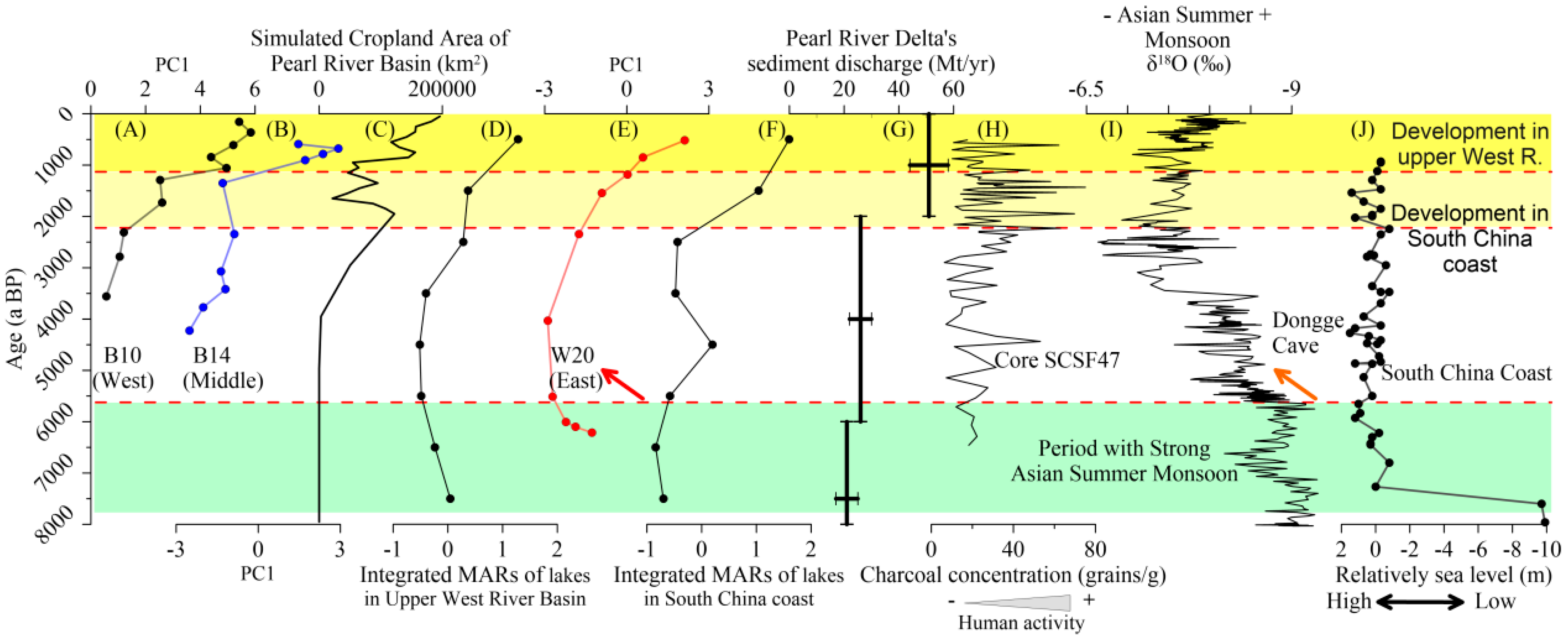
The temporal variations in PC1 are divided into three stages for cores B10 and B14 and four stages for core W20 (Figure 6). The period of 5.8–2.6 ka BP has the lowest PC1 values, indicating the lowest soil erosion intensity. In contrast, the higher PC1 values occurred in ~6.5–5.8 ka BP and since ~2.2 ka BP. To reveal the natural and anthropogenic factors controlling the terrigenous input intensity, the PC1 values and other paleo-environmental proxies, including the cropland area of the Pearl River Basin, summer monsoon intensity, sea level, human-driven soil erosion features in the upper West River and South China coast, estimated sediment discharge of the Pearl River Delta, charcoal concentration of core SCSF47 are compared in Figure 6.
Initially, for much of approximately 6.5–5 ka BP, the variability in PC1 of core W20 closely tracks the δ18 O of Dongge Cave stalagmites (Figure 6I), the proxy of the summer monsoon intensity [32]. The sea level was stable at that time (Figure 6J) [44], so it could not be the main factor controlling the variable terrigenous input and soil erosion. This strong consistence of PC1 and summer monsoon intensity indicates a primary natural climatic driver, where enhanced summer precipitation led to increased soil erosion and fluvial sediment transport from the Pearl River catchment, via the estuary and delta, to the outer shelf [37].
Notably, a significant decoupling from this long-term natural climatic template (i.e., the natural evolutionary trend of the summer monsoon) occurred since ~2.2 ka BP, marking the growing overprint of anthropogenic forcing. The PC1 record diverged from the relatively stable or declining summer monsoon trend since ~2.2 ka BP (Figure 6), instead showing substantial and often rapid increases in terrigenous input. As reflected by the proxies of heavy metals [28,29], charcoal concentration of core SCSF47 (Figure 6H) [30], rice-agriculture-related pollen [45], and chemical weathering [25], it was demonstrated that human activities overwhelmed the nature factors in the PRE shelf system since 3–2 ka BP. In addition, the simulated cropland area of the Pearl River Basin [46] has expanded since the Late Holocene (Figure 6C). As a result, the PRE entered a period of rapid sedimentation, and the Pearl River Delta plain in the estuarine and adjacent coastal area formed and expanded rapidly since ~2.2 ka BP due to enhanced sediment deposition (Figure 6G) [47]. Therefore, it can be inferred that the terrigenous input intensity from the Pearl River catchment, through the estuary and delta, to the outer shelf, as obtained in this study, has increased with the intensification of human activities.
Furthermore, our records reveal notable spatial heterogeneity in this anthropogenic signal across the South China coast, providing a more nuanced picture than previous reconstructions. The western sites (B10 and B14) exhibit a slight fluctuation around 2.2 ka BP, a decline in PC1 at approximately 1.5 ka BP, followed by a very rapid increase in PC1 after 1.2 ka BP. This trajectory closely mirrors the simulated history of cultivated land area in the Pearl River Basin (Figure 6C) [46] and the independent records of soil erosion intensity from the West River upstream region as reflected by the lake sediment mass accumulation rates (MARs) (Figure 6D) [17]. This pattern strongly suggests that the western shelf area is predominantly influenced by sediment fluxes from the Pearl River system, with its recent history tightly coupled to land-use changes within the main river catchment, especially the mainstream of the West River. In contrast, the eastern site (W20) displays a more sustained increase in terrigenous input over the past 2 ka. This trend correlates well with the documented timeline of intensified human activities along the broader South China coast, such as the sediment records of UV1 [28] and the integrated sediment MARs of the lakes along the South China coast (Lower Pearl River Basin) (Figure 6F) [17]. This indicates that the eastern shelf mainly receives sediment inputs from adjacent coastal catchments, with potential contributions from along-shelf sediment transport, thus reflecting a more regional anthropogenic signal across the South China coast.
Figure 6. Temporal variations in (A) PC1 of cores B10, (B) B14, and (E) W20 and other related parameters, including (C) the simulated cropland area of the Pearl River Basin [46], (D) integrated sediment mass accumulation rates (MARs) of lakes in Upper West River Basin [17], (F) integrated sediment MARs of lakes along South China coast (Lower Pearl River Basin) [17], (G) estimated sediment discharge of Pearl River Delta [47], (H) charcoal concentration of core SCSF47 [30], (I) δ18O of Dongge Cave stalagmites [32], and (J) relative sea level along southeast coast of China [44].
Jmse 14 00467 g006

4.3. A Spatially Related Model of Human–Environment Interaction in the PRE Shelf System

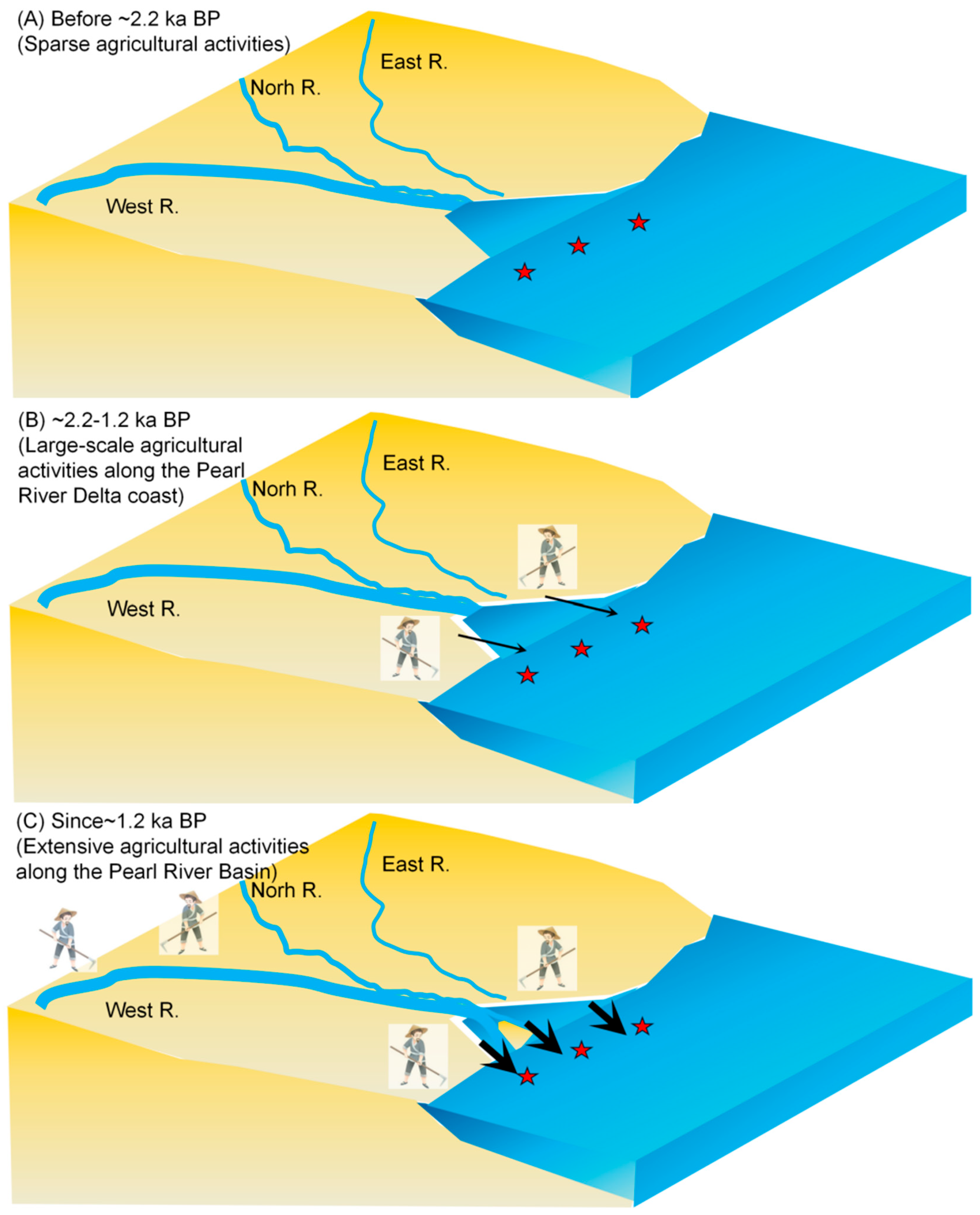
Our records support the viewpoint that the human-impacted sedimentary environment across the study area is time-transgressive; that is, the timing and intensity of human influence on the sedimentary system differ spatially among shelf sites. The differential response is likely governed by the specific sediment pathways and proximity to major fluvial point sources. Due to their locations (Figure 1A,B), B10 and B14 directly record the erosional history of the Pearl River Basin, particularly the West River, while the W20 core captures a more integrated signal from regional rivers, such as the coastal mountain rivers of Hong Kong [48]. Thus, our results show a distinct history of human impact on the coastal sediment, and the spatially related model of the human–environment interaction in the northern SCS shelf is illustrated in Figure 7.
The human–environment interaction in the northern SCS shelf can be divided into three stages.
Stage 1 (Pre-2.2 ka BP) is a time with predominantly natural forcing (Figure 7A). At that time, the terrigenous input across the shelf was controlled by climatic conditions, according to this study and shown by comparing the Pearl River sedimentary organic carbon isotope ratios [49], chemical weathering index [25,29], and summer monsoon intensity [21].
Stage 2 (2.2–1.2 ka BP) is the onset of human activity intensification along coastal South China. At about 2.2 ka BP, about 500,000 residents immigrated into Guangzhou city, in the central Pearl River Delta, South China coast, after the battle of Qin against the Baiyue. After that time, strong soil erosion occurred along the South China coast, which caused higher PC1 values in cores B10 and W20 (Figure 7B). This increase in PC1 does not reflect a natural phenomenon but directly records enhanced terrigenous input driven by anthropogenic soil erosion. B14, located far away from the coast at a water depth of 33.2 m, shows no remarkable response to the change.
In Stage 3 (since 1.2 ka BP), human activity expanded to the West River hinterland. History records show that large-scale immigration to the Upper West River occurred at that time (Late Tang Dynasty and Song Dynasty), and the “Dali” Kingdom was established. Human activity signals in the Upper West River (the main trunk of the Pearl River catchment, rather than the delta plain) are recorded in sediment cores from many lakes [50,51], indicating that the entire Pearl River Basin had entered a period of intensive anthropogenic development. Hence, the northern SCS shelf area covered by our three cores (maximum water depth: 46.8 m) has been dominated by an anthropogenic signature since that time.

5. Conclusions

Based on elemental analyses of cores B10, B14 and W20 from the Pearl River Estuary (PRE) shelf, three findings can be concluded as follows:
(1) PC1, dominated by lithogenic elements (Fe, Al, V, Cs, Rb, etc.), serves as a reliable proxy for fine-grained terrigenous input and catchment soil erosion.
(2) PC1 records show clear spatial differences: western cores (B10, B14) reflect human-driven erosion linked to the upper West River basin, while the eastern core (W20) indicates continuous terrigenous input consistent with coastal South China human activity records.
(3) A spatial model of human–environment interactions is proposed, highlighting the time-transgressive nature of human impact (spatiotemporal differences in anthropogenic signals) in the PRE shelf system and refining its sediment source-to-sink framework.

Supplementary Materials

The following supporting information can be downloaded at: https://www.mdpi.com/article/10.3390/jmse14050467/s1, Table S1: Results of major elements for the 3 studied cores; Table S2: Results of trace elements for the 3 studied cores.

Author Contributions

Conceptualization, M.T. and M.L.; methodology, R.W. and J.L.; software, Z.M.; validation, J.L.; formal analysis, M.T.; investigation, M.T. and L.C.; resources, L.C.; data curation, J.L.; writing—original draft preparation, M.T.; writing—review and editing, M.L.; visualization, M.L. and Z.M.; supervision, L.C. and M.L.; project administration, L.C.; funding acquisition, M.T. and M.L. All authors have read and agreed to the published version of the manuscript.

Funding

This research was funded by the Science and Technology Development Foundation of South China Sea Bureau, Ministry of Natural Resources (grant No. 240106), Key Laboratory of Marine Environmental Survey Technology and Application, Ministry of Natural Resources (grant No. MESTA-2023-A004), Guangdong Basic and Applied Basic Research Foundation, China (grant No. 2023A1515010675), Guangzhou Sci-Tech Intelligent Management Platform Project (grant No. 2023A04J1992), and Lingnan Normal University (Grant No. ZL2520, HYMC2501006).

Data Availability Statement

All the data are provided in this article.

Acknowledgments

Thanks to Chao Huang of Guangdong Ocean University for his assistance in grain size testing.

Conflicts of Interest

The authors declare no conflicts of interest.

References

  1. Crutzen, P.J. Geology of mankind. Nature 2002, 415, 23. [Google Scholar] [CrossRef] [Scilit]
  2. Zalasiewicz, J.; Head, M.; Waters, C.; Summerhayes, C.; Turner, S.; Wagreich, M.; Aquilina, L.; Cearreta, A.; Chakraborty, A.; Gałuszka, A.; et al. Reply to Edgeworth et al. (2024): The Anthropocene Is a Time Interval, and More Besides. Earth’s Future 2025, 13, e2024EF004906. [Google Scholar] [CrossRef] [Scilit]
  3. Edgeworth, M. Transgressing time: Archaeological evidence in/of the Anthropocene. Annu. Rev. Anthropol. 2021, 50, 93–108. [Google Scholar] [CrossRef] [Scilit]
  4. Edwards, L.E.; Bauer, A.; Edgeworth, M.; Ellis, E.; Finney, S.; Gibbard, P.; Gill, J.L.; Maslin, M.; Merritts, D.; Ruddiman, W. The Anthropocene serves science better as an event, rather than an epoch. J. Quat. Sci. 2022, 37, 1188. [Google Scholar] [CrossRef] [Scilit]
  5. Gibbard, P.; Walker, M.; Bauer, A.; Edgeworth, M.; Edwards, L.; Ellis, E.; Finney, S.; Gill, J.L.; Maslin, M.; Merritts, D. The Anthropocene as an Event, not an Epoch. J. Quat. Sci. 2022, 37, 395–399. [Google Scholar] [CrossRef] [Scilit]
  6. McCarthy, F.; Head, M.; Waters, C.; Zalasiewicz, J. Would Adding the Anthropocene to the Geologic Time Scale Matter? AGU Adv. 2025, 6, e2024AV001235. [Google Scholar] [CrossRef] [Scilit]
  7. Waters, C.N.; Zalasiewicz, J.; Summerhayes, C.; Barnosky, A.D.; Poirier, C.; Gałuszka, A.; Cearreta, A.; Edgeworth, M.; Ellis, E.C.; Ellis, M.; et al. The Anthropocene is functionally and stratigraphically distinct from the Holocene. Science 2016, 351, aad2622. [Google Scholar] [CrossRef] [Scilit]
  8. Zalasiewicz, J.; Waters, C.N.; Williams, M.; Barnosky, A.D.; Cearreta, A.; Crutzen, P.; Ellis, E.; Ellis, M.A.; Fairchild, I.J.; Grinevald, J.; et al. When did the Anthropocene begin? A mid-twentieth century boundary level is stratigraphically optimal. Quat. Int. 2015, 383, 196–203. [Google Scholar] [CrossRef] [Scilit]
  9. Ruddiman, W. Geographic evidence of the early anthropogenic hypothesis. Anthropocene 2017, 20, 4–14. [Google Scholar] [CrossRef] [Scilit]
  10. Ruddiman, W.F. The anthropogenic greenhouse era began thousands of years ago. Clim. Change 2003, 61, 261–293. [Google Scholar] [CrossRef] [Scilit]
  11. Hooke, R.L. On the history of humans as geomorphic agents. Geology 2000, 28, 843–846. [Google Scholar]
  12. Jenny, J.-P.; Koirala, S.; Gregory-Eaves, I.; Francus, P.; Niemann, C.; Ahrens, B.; Brovkin, V.; Baud, A.; Ojala, A.E.; Normandeau, A.; et al. Human and climate global-scale imprint on sediment transfer during the Holocene. Proc. Natl. Acad. Sci. USA 2019, 116, 22972–22976. [Google Scholar] [PubMed]
  13. Wilkinson, B.H. Humans as geologic agents: A deep-time perspective. Geology 2005, 33, 161–164. [Google Scholar] [CrossRef] [Scilit]
  14. Ju, M.; Wan, S.; Clift, P.D.; Pei, W.; Jiao, D.; Zhang, J.; Jiao, W.; Zhao, D.; Yu, Z.; Song, Z.; et al. History of human activity in South China since 7 cal ka BP: Evidence from a sediment record in the South China Sea. Quat. Sci. Rev. 2024, 333, 108683. [Google Scholar] [CrossRef] [Scilit]
  15. Zhang, F.; Li, S.; Sun, C.; Li, W.; Zhao, X.; Chen, Z.; Nie, T.; Chen, Y.; Li, X. Human impacts overwhelmed hydroclimate control of soil erosion in China 5000 years ago. Geophys. Res. Lett. 2022, 49, e2021GL097355. [Google Scholar]
  16. Edwards, K.J.; Whittington, G. Lake sediments, erosion and landscape change during the Holocene in Britain and Ireland. Catena 2001, 42, 143–173. [Google Scholar] [CrossRef] [Scilit]
  17. Yuan, Y.; Zhou, X.; Zhu, A.; Luo, Y.; Xue, H.; Liu, X.; Tu, L.; Shen, Y. Asynchronous onset of anthropogenic soil erosion in monsoonal China during the Holocene. Palaeogeogr. Palaeoclimatol. Palaeoecol. 2023, 624, 111653. [Google Scholar] [CrossRef] [Scilit]
  18. Amorosi, A.; Sammartino, I.; Dinelli, E.; Campo, B.; Guercia, T.; Trincardi, F.; Pellegrini, C. Provenance and sediment dispersal in the Po-Adriatic source-to-sink system unraveled by bulk-sediment geochemistry and its linkage to catchment geology. Earth-Sci. Rev. 2022, 232, 104202. [Google Scholar]
  19. Gao, S.; Wang, D.; Yang, Y.; Zhou, L.; Zhao, Y.; Gao, W.; Han, Z.; Yu, Q.; Li, G. Holocene sedimentary systems on a broad continental shelf with abundant river input: Process–product relationships. Geol. Soc. Lond. Spec. Publ. 2016, 429, 223–259. [Google Scholar]
  20. Syvitski, J.; Ángel, J.R.; Saito, Y.; Overeem, I.; Vörösmarty, C.J.; Wang, H.; Olago, D. Earth’s sediment cycle during the Anthropocene. Nat. Rev. Earth Environ. 2022, 3, 179–196. [Google Scholar] [CrossRef] [Scilit]
  21. Xiong, H.; Zong, Y.; Huang, G.; Fu, S. Human drivers accelerated the advance of Pearl River deltaic shoreline in the past 7500 years. Quat. Sci. Rev. 2020, 246, 106545. [Google Scholar] [CrossRef] [Scilit]
  22. Li, G.; Miao, L.; Yan, W. Holocene evolution of the shelf mud deposits in the north-western South China Sea. Front. Mar. Sci. 2022, 9, 913849. [Google Scholar] [CrossRef] [Scilit]
  23. Zhao, H.; Lin, Y.; Delang, C.O.; Ma, Y.; Zhou, J.; He, H. Contribution of soil erosion to the evolution of the plateau-plain-delta system in the Yellow River basin over the past 10,000 years. Palaeogeogr. Palaeoclimatol. Palaeoecol. 2022, 601, 111133. [Google Scholar] [CrossRef] [Scilit]
  24. Liu, J.; Yan, W.; Chen, Z.; Chen, H.; Lu, J. Comment on “Holocene evolution in weathering and erosion patterns in the Pearl River delta” by Hu et al. Geochem. Geophys. Geosyst. 2014, 15, 2727–2731. [Google Scholar] [CrossRef] [Scilit]
  25. Pei, W.; Wan, S.; Clift, P.D.; Cai, G.; Zhao, D.; Zhang, J.; Jiao, W.; Ju, M.; Song, Z.; Li, A. Farming stimulated stronger chemical weathering in South China since 3.0 ka BP. Quat. Sci. Rev. 2023, 307, 108065. [Google Scholar] [CrossRef] [Scilit]
  26. Qiao, Y.; Liu, J.; Cao, L.; Khan, M.H.R.; Xu, X.; Tan, L. Contribution of continuously stable sediment input to the formation of the Pearl River delta since the middle Holocene. Quat. Int. 2021, 598, 78–89. [Google Scholar] [CrossRef] [Scilit]
  27. Xiong, H.; Lu, B.; Wang, Q.; Zhang, Z.; Zong, Y.; Liao, W.; Zhang, H.; Zhao, M.; Wu, J. Mouth bars’ development along the West Pearl River main course. Catena 2024, 245, 108337. [Google Scholar] [CrossRef] [Scilit]
  28. Zong, Y.; Yu, F.; Huang, G.; Lloyd, J.M.; Yim, W.W.S. Sedimentary evidence of Late Holocene human activity in the Pearl River delta, China. Earth Surf. Process. Landf. 2010, 35, 1095–1102. [Google Scholar] [CrossRef] [Scilit]
  29. Huang, C.; Zeng, T.; Ye, F.; Xie, L.; Wang, Z.; Wei, G.; Lo, L.; Deng, W.; Rao, Z. Natural and anthropogenic impacts on environmental changes over the past 7500 years based on the multi-proxy study of shelf sediments in the northern South China Sea. Quat. Sci. Rev. 2018, 197, 35–48. [Google Scholar] [CrossRef] [Scilit]
  30. Yu, S.; Chen, F.; Jing, X.; Chen, C.; Zhuang, C.; Li, Q.; Zhou, Y.; Xia, Z.; Gan, H.; Fisch, K.; et al. Increasing terrigenous pollen input in the late Holocene: Indications of intensive human activity and accelerated delta plain progradation. Mar. Geol. 2021, 440, 106547. [Google Scholar] [CrossRef] [Scilit]
  31. Li, M.; Tang, M.; Chen, L.; Zeng, Y.; Wen, R.; Lin, J.; Yu, M. Magnetic mineral dissolution front delimited by late Holocene sediment accumulation acceleration in the inner shelf, northern South China Sea. Palaeogeogr. Palaeoclimatol. Palaeoecol. 2025, 679, 113263. [Google Scholar] [CrossRef] [Scilit]
  32. Dykoski, C.A.; Edwards, R.L.; Cheng, H.; Yuan, D.; Cai, Y.; Zhang, M.; Lin, Y.; Qing, J.; An, Z.; Revenaugh, J. A high-resolution, absolute-dated Holocene and deglacial Asian monsoon record from Dongge Cave, China. Earth Planet. Sci. Lett. 2005, 233, 71–86. [Google Scholar] [CrossRef] [Scilit]
  33. An, Z. The history and variability of the East Asian paleomonsoon climate. Quat. Sci. Rev. 2000, 19, 171–187. [Google Scholar] [CrossRef] [Scilit]
  34. Zong, Y.; Huang, G.; Switzer, A.; Yu, F.; Yim, W.-S. An evolutionary model for the Holocene formation of the Pearl River delta, China. Holocene 2009, 19, 129–142. [Google Scholar] [CrossRef] [Scilit]
  35. Wang, Y.; Chen, X.; Switzer, A.; Li, L.; Xu, Y.; Wang, Y.; Zhang, P. Relict and Modern Sediments on the Continental Shelf of the Northern South China Sea: A Reconsideration. J. Geophys. Res. Earth Surf. 2023, 128, e2023JF007197. [Google Scholar] [CrossRef] [Scilit]
  36. Gao, S.; Liu, Y.; Yang, Y.; Liu, P.J.; Zhang, Y.; Wang, Y.P. Evolution status of the distal mud deposit associated with the Pearl River, northern South China Sea continental shelf. J. Asian Earth Sci. 2015, 114, 562–573. [Google Scholar] [CrossRef] [Scilit]
  37. Li, M.; Ouyang, T.; Zhu, Z.; Tian, C.; Peng, S.; Zhong, H.; Peng, X.; Qiu, Y. Reconstruction of chemical weathering intensity and Asian Summer monsoon evolution in the Red River Basin over the past 36 kyr. Paleoceanogr. Paleoclimatol. 2022, 37, e2021PA004397. [Google Scholar] [CrossRef] [Scilit]
  38. Liu, J.; Chen, J.; Selvaraj, K.; Xu, Q.; Wang, Z.; Chen, F. Chemical weathering over the last 1200 years recorded in the sediments of Gonghai Lake, Lvliang Mountains, North China: A high-resolution proxy of past climate. Boreas 2014, 43, 914–923. [Google Scholar]
  39. Kaboth-Bahr, S.; Bahr, A.; Yamoah, K.A.; Chuang, C.-K.; Li, H.-C.; Su, C.-C.; Wei, K.-Y. Rapid humidity changes across the Northern South China Sea during the last ~40 kyrs. Mar. Geol. 2021, 440, 106579. [Google Scholar] [CrossRef] [Scilit]
  40. Li, T.; Li, X.; Zhang, J.; Luo, W.; Tian, C.; Zhao, L. Source identification and co-occurrence patterns of major elements in South China Sea sediments. Mar. Geol. 2020, 430, 106285. [Google Scholar]
  41. Zhang, L.; Chen, M.; Chen, Z.; Xiang, R.; Liu, J. Distribution of calcium carbonate and its controlling factors in surface sediments of the South China Sea. Earth Sci. J. China Univ. Geosci. 2010, 35, 891–898. [Google Scholar]
  42. Li, G.; Yan, W.; Zhong, L. Element geochemistry of offshore sediments in the northwestern South China Sea and the dispersal of Pearl River sediments. Prog. Oceanogr. 2016, 141, 17–29. [Google Scholar] [CrossRef] [Scilit]
  43. Kao, S.-J.; Horng, C.-S.; Roberts, A.P.; Liu, K.-K. Carbon–sulfur–iron relationships in sedimentary rocks from southwestern Taiwan: Influence of geochemical environment on greigite and pyrrhotite formation. Chem. Geol. 2004, 203, 153–168. [Google Scholar] [CrossRef] [Scilit]
  44. Zong, Y. Mid-Holocene sea-level highstand along the Southeast Coast of China. Quat. Int. 2004, 117, 55–67. [Google Scholar] [CrossRef] [Scilit]
  45. Ma, T.; Rolett, B.V.; Zheng, Z.; Zong, Y. Holocene coastal evolution preceded the expansion of paddy field rice farming. Proc. Natl. Acad. Sci. USA 2020, 117, 24138–24143. [Google Scholar] [CrossRef] [Scilit] [PubMed]
  46. Goldewijk, K.; Beusen, A.; Doelman, J.; Stehfest, E. Anthropogenic land use estimates for the Holocene–HYDE 3.2. Earth Syst. Sci. Data 2017, 9, 927–953. [Google Scholar] [CrossRef] [Scilit]
  47. Wei, X.; Wu, C.; Ni, P.; Mo, W. Holocene delta evolution and sediment flux of the Pearl River, southern China. J. Quat. Sci. 2016, 31, 484–494. [Google Scholar] [CrossRef] [Scilit]
  48. Yang, S.; Zheng, Z.; Tan, H.; Zhang, Z.; Wang, H.; Li, J.; Laws, E.A. Environmental changes and human activity since the Neolithic: Evidence from pollen and phytoliths in Hochung, Sai Kung area, Hong Kong. Rev. Palaeobot. Palynol. 2018, 258, 36–47. [Google Scholar] [CrossRef] [Scilit]
  49. Wu, M.-S.; Zong, Y.; Mok, K.-M.; Cheung, K.-M.; Xiong, H.; Huang, G. Holocene hydrological and sea surface temperature changes in the northern coast of the South China Sea. J. Asian Earth Sci. 2017, 135, 268–280. [Google Scholar] [CrossRef] [Scilit]
  50. Chen, X.; Huang, X.; Wu, D.; Chen, J.; Zhang, J.; Zhou, A.; Dodson, J.; Zawadzki, A.; Jacobsen, G.; Yu, J.; et al. Late Holocene land use evolution and vegetation response to climate change in the watershed of Xingyun Lake, SW China. Catena 2022, 211, 105973. [Google Scholar] [CrossRef] [Scilit]
  51. Wu, D.; Zhou, A.; Liu, J.; Chen, X.; Wei, H.; Sun, H.; Yu, J.; Bloemendal, J.; Chen, F. Changing intensity of human activity over the last 2,000 years recorded by the magnetic characteristics of sediments from Xingyun Lake, Yunnan, China. J. Paleolimnol. 2015, 53, 47–60. [Google Scholar] [CrossRef] [Scilit]
Figure 2. Down-core variations in major elements of B10, B14, and W20.
Jmse 14 00467 g002
Figure 3. Down-core variations in trace elements of the 3 studied cores.
Jmse 14 00467 g003
Figure 4. Correlation plots of the measured elements for all samples from cores B10, B14 and W20 combined. Note: * p < 0.05. Correlation coefficients were calculated using Spearman’s rank correlation.
Jmse 14 00467 g004
Figure 5. Biplot of the first two principal components (PC1 and PC2) with loadings of the analyzed elements.
Jmse 14 00467 g005
Figure 7. Models of the signal transmissions of enhanced human activities and the evolution pattern of the PRE shelf system. The stars represent the location of the study cores, and the arrows indicate the terrigenous input. The thicker the arrow, the higher the terrigenous input.
Jmse 14 00467 g007
Table 1. PCA results of elements (The bolded numbers indicate the maximum absolute loading values).
ElementsPC1PC2PC3PC4
TFe2O30.9950.064 −0.032 0.011
Al2O30.9880.001 −0.101 0.035
SiO2−0.9830.100 −0.011 −0.097
V0.9770.104 0.050 −0.101
Cs0.9770.146 0.010 −0.063
Rb0.9710.121 0.052 −0.135
Ga0.9680.017 −0.166 0.003
TiO20.9660.115 0.090 −0.040
K2O0.9600.126 0.144 −0.130
CaO−0.951−0.186 0.082 0.033
Ta0.9430.121 −0.071 0.040
Nb0.9430.161 −0.178 0.043
MnO0.9300.161 −0.146 −0.169
Th0.9240.127 −0.201 0.061
LOI0.904−0.324 −0.038 0.191
Sr−0.900−0.126 0.195 −0.139
Cl0.887−0.316 0.043 0.218
Y0.8350.263 −0.164 0.102
P2O50.675−0.243 −0.251 0.251
Hf−0.6550.620 −0.318 0.114
Na2O0.650−0.579 0.257 0.129
Ba0.6370.276 −0.014 −0.547
Zr−0.5730.669−0.298 −0.038
SO30.1510.433 0.830−0.019
MgO0.5330.150 0.774−0.030
U−0.0620.622 0.238 0.676
Variance (%)70.9329.221 7.347 4.092
Disclaimer/Publisher’s Note: The statements, opinions and data contained in all publications are solely those of the individual author(s) and contributor(s) and not of MDPI and/or the editor(s). MDPI and/or the editor(s) disclaim responsibility for any injury to people or property resulting from any ideas, methods, instructions or products referred to in the content.