Article

A New Methodological Model for Designating Transboundary Marine Protected Areas

1
Marine Research Institute, Klaipeda University, 92295 Klaipeda, Lithuania
2
Administration of Lithuania Minor Protected Areas, 99349 Rusnė, Lithuania
3
Division of Environmental Toxicology, Medical University of Gdansk, 80-204 Gdansk, Poland
4
Department of Social Geography and Tourism, Klaipeda University, 92294 Klaipėda, Lithuania
*
Author to whom correspondence should be addressed.
J. Mar. Sci. Eng. 2026, 14(19), 1770; https://doi.org/10.3390/jmse14191770
Submission received: 26 July 2026 / Revised: 5 September 2026 / Accepted: 14 September 2026 / Published: 22 September 2026

Abstract

Transboundary marine protected areas (TMPAs) are designed to conserve ecological features and processes that cross maritime jurisdictions. Still, effective designation requires integrating ecological evidence with diverse legal, spatial-planning, institutional, and management systems. This study develops an operational methodology for identifying, delineating, designating, and managing offshore TMPAs, grounded in a structured analysis of 288 scientific, legal, policy, technical, and institutional records in six languages. The resulting framework adapts established concepts into a 20-component, stepwise procedure that links ecological connectivity, spatial delineation, cumulative-pressure assessment, regulatory equivalence, governance, monitoring, and adaptive management. We appraised source authority, quality, relevance, and evidentiary strength using a source-specific hierarchy and treated uncertainty qualitatively at each stage. We tested the methodology in the South Baltic area, focusing on the Critically Endangered Baltic Proper harbor porpoise (Phocoena phocoena), estimated at 400–500 individuals and exhibiting significant seasonal concentrations. Six analytical steps operationalized the framework, resulting in a preliminary spatial structure comprising three core areas, four ecological corridors, and three supporting areas across Lithuania, Poland, and Sweden. Legal and institutional comparisons revealed substantial compatibility through shared European Union (EU) and Helsinki Commission (HELCOM) frameworks, while also identifying differences in monitoring, permitting, fisheries regulation, enforcement, and management arrangements. The case study demonstrates the methodology’s internal coherence and operational applicability; however, it provides no evidence of ecological effectiveness, as the proposed TMPA has not been formally designated or prospectively monitored. Uncertainties persist regarding species distribution, cumulative impacts, final boundaries, and the implementation of equivalent measures across jurisdictions. Therefore, the model is reproducible and can practically support decision-making for structuring TMPA planning and identifying key ecological, legal, and governance requirements. The model’s future development should focus on testing in non-EU settings and areas beyond national jurisdiction.

1. Introduction

The marine environment is a natural realm for many endangered species, especially migratory ones. It provides feeding grounds, habitats, and migratory corridors, so various types of coastal and marine nature protection areas cover it. They are also considered important for protecting the seas and oceans from overfishing [1], and for ensuring the sustainable use of marine biological and mineral resources [2]. Marine protection areas (MPAs) are an important element of biodiversity protection because of the number of species found in the marine environments of these areas.
Since the beginning of the 21st century, the role of MPAs has been increasingly recognised, and their number has grown [3]. The International Union for Conservation of Nature (IUCN) defines MPAs broadly, including areas affected by tides, together with waters, flora and fauna, and cultural or historical features located in these areas. They must be protected by law or another effective form of protection [4]. However, no unambiguous legal definition of an MPA covers all initiatives in this sector.
The idea of creating ecological networks comprising a series of MPAs is grounded in the belief that preserving natural heritage requires thinking about space and perceiving it as a continuous whole in structural, functional, and legal terms [5]. In this context, designating transboundary MPAs (TMPAs) is necessary for marine ecological networks. Such designation creates a ‘virtuous circle’: a series of TMPAs yields a synergistic conservation effect [4].
In 2003, the First Joint Ministerial Meeting of the Baltic Sea Environment Commission (Helsinki Commission or HELCOM) and the Northeast Atlantic Environment Commission (Oslo–Paris Commission or OSPAR) took place in Bremen. There, the Member States of the European Union (EU) represented in OSPAR and HELCOM, together with representatives of the European Commission (EC), adopted the Joint Work Program [6]. This program aimed to create a comprehensive system of MPAs in the Baltic Sea and the Northeast Atlantic by 2010.
This EU development coincided with relevant United Nations (UN) initiatives, linking regional developments to a broader international context. The Aichi Biodiversity Targets, adopted in 2010 by the UN Convention on Biological Diversity (CBD), set 20 targets to reduce global biodiversity loss from 2011 to 2020, including Target 3 to effectively conserve and manage at least 30% of the world’s land, inland waters, and coastal and marine areas by the year 2030. These targets also included Aichi Target 11, which aims to protect the global marine environment.
Hence, a strong political commitment is essential to collaborate on establishing high-seas TMPA networks [7,8]. Achieving global ocean conservation goals requires identifying approaches that could scale up sustainable ocean management [9,10]. MPAs, particularly TMPAs, are central to international maritime commitments [11]. Greater recognition of the importance of healthy oceans must lead to concrete actions to reverse global ocean degradation [10]. Yet, many priority areas, including designated Key Biodiversity Areas (KBAs), remain unprotected [12].
Achieving an ambitious ‘30 by 30’ objective requires a comprehensive TMPA implementation strategy. Effective offshore TMPA management depends on programs that integrate all marine sectors and coordinate efforts from the local to the global level [13]. Marine migratory species (MMS) are central to TMPAs for conserving marine biodiversity. Hence, the Convention on the Conservation of Migratory Species of Wild Animals (CMS) should serve as the primary framework for establishing TMPAs [14].
Summing up, the objective of the study was to propose a new methodological model for establishing viable offshore TMPAs contributing to the ‘30 by 30’ objective in the European seas. To address these objectives, this paper is organized as follows: First, we describe the research methods using a comprehensive documentation analysis. Then we present the results and discuss their critical interpretation. Our central, original research result is a functional scheme describing the executable TMPA designation procedures. Next, we present the case study of a South Baltic offshore MPA spanning Exclusive Economic Zones (EEZs) of Lithuania, Poland, and Sweden. Finally, we draw the conclusion based on the evidence provided by this study.
International law plays an important role in protecting the marine environment and its natural resources. There are strong arguments for using international legal regulation. These include the international nature of navigation, seabed exploration, and exploitation. They also include the transboundary nature of marine pollution and the diverse, unique marine fauna, flora, ecosystems, and biodiversity [15]. The governance, management, and regulation of maritime activities worldwide are guided by the UN Charter [13].
Several UN conventions set indicators and targets to measure progress toward sustainable development and ocean health [10]. These include the CBD, the UN Framework Convention on Climate Change (UNFCCC), the UN Convention on the Law of the Sea (UNCLOS), and the UN 2030 Agenda for Sustainable Development, which outlines 17 Sustainable Development Goals (SDGs). The UN 2030 Agenda for Sustainable Development includes SDG 14 (Life Below Water). It aims to conserve and sustainably use the oceans, seas, and marine resources for sustainable development [16].
International law has led to the creation of specific environmental regime areas that are linked to maritime economic activities. These include Particularly Sensitive Sea Areas (PSSAs) under the International Convention for the Prevention of Pollution from Ships (MARPOL) [17,18]. UNCLOS provides the overarching legal framework, including marine environment protection, for maritime zones. It covers territorial seas, exclusive economic zones, continental shelves, high seas, and enclosed or semi-enclosed seas. It also transposes other UN Charter principles to the sea, including the obligation not to cause environmental harm [13].
UNCLOS Articles 192–237 (Protection and Preservation of the Marine Environment) are particularly relevant to the establishment of MPAs. They set out the general duty to protect and preserve the marine environment. The EU is bound by UNCLOS and other conventions to which it is a party [15]. Article 4 §6 of the UNCLOS states that obligations from this act take precedence over EU law. It also makes clear that the Convention’s primacy applies to both primary and secondary law [19]. This principle was confirmed by the European Court of Justice (ECJ) [20].
However, UNCLOS alone does not provide a detailed protected-area regime for offshore TMPAs. Its provisions must be implemented alongside biodiversity, fisheries, shipping, regional seas, and species-conservation instruments. The CBD provides a biodiversity framework, including the Kunming-Montreal Global Biodiversity Framework (2022) [21], which established the ‘30 by 30’ objective, and the criteria for establishing Ecologically or Biologically Significant Marine Areas (EBSAs). These criteria are highly relevant to TMPA designation. They emphasize uniqueness, rarity, life-history importance, threatened species, vulnerability, productivity, biological diversity, and naturalness of marine areas.
MMS frequently pass through multiple national jurisdictions and areas beyond national jurisdiction (ABNJ), making unilateral protection insufficient. CMS and its daughter agreements, including the Agreement on the Conservation of Cetaceans of the Black and Mediterranean Seas (ACCOBAMS), Agreement on the Conservation of Cetaceans of the Baltic and North Seas (ASCOBANS), Agreement on the Conservation of Albatrosses and Petrels (ACAP), and the Wadden Sea Seals Agreement, provide mechanisms for coordinated protection of marine mammals, birds, and other MMS [22].
Duty to cooperate in protection of environment (including marine environment) is not only included in numerous soft law and specific hard law instruments but is also considered as “fundamental principle” of international law by international tribunals [23]. This makes the creation of TMPA’s important tool of fulfilling international obligations of states. Progress toward the ‘30 by 30’ goal in European seas is shaped by EU directives and regional conventions, which together frame the development of offshore TMPAs.
The Habitats Directive (Directive 92/43/EEC), Birds Directive (Directive 2009/147/EC), Marine Strategy Framework Directive (Directive 2008/56/EC, MSFD) and Maritime Spatial Planning Directive (Directive 2014/89/EU, MSPD) mandate coordinated marine conservation among member states and encourage collaboration with non-EU neighbors to achieve Good Environmental Status (GES). Regional environmental protection conventions such as the Helsinki Convention for the Baltic Sea, the Oslo–Paris Convention for the North-East Atlantic, the Barcelona Convention for the Mediterranean and Adriatic seas, and the Bucharest Convention for the Black Sea reinforce these efforts.
The interplay of these instruments creates a complex legal and institutional landscape [24,25]. For example, many Baltic Sea (aka HELCOM) MPAs are designated simultaneously under HELCOM and as EU Natura 2000 sites. This overlap reflects an earlier division: Natura 2000 areas focused on terrestrial protection, while the creation of MPAs in maritime regions was left to international instruments [26]. Hence, HELCOM and OSPAR agreed that marine Natura 2000 sites should meet the criteria for inclusion in the OSPAR/HELCOM network of MPAs [27].
In the early years of Natura 2000 sites, there were opinions in the doctrine questioning the possibility of using this instrument for MPAs, particularly regarding areas beyond the territorial sea [28]. However, the ECJ ruled in 1993 that the EU had competence to introduce environmental protection standards extending beyond the territorial framework of the EU countries. This extent is within the framework of competences resulting from international law [29].
The year 2012 was pivotal for the development of the network of marine Natura 2000 areas. The EU Action Plan envisaged setting management priorities and the necessary conservation measures for Special Areas of Conservation (SACs) in the marine environment, and establishing similar management priorities and conservation measures for Special Protection Areas for Birds (SPAs) by 2012 [30]. These activities completed the normative stage of shaping the Natura 2000 marine protection system and marked the sixth Environmental Action Program [31].
However, the differences between HELCOM and OSPAR MPAs and marine Natura 2000 areas are evident in their approaches. The former prioritizes building an MPA network of a few large protected areas. The argument goes that large MPAs conserve many habitats and support large populations of species, especially MMS. The guidelines for creating HELCOM MPAs set the minimum area at 3000 hectares [32]. Meanwhile, Natura 2000 series reflect a conservation philosophy based on the metapopulation theory [30].
When discussing the instruments supporting TMPA development, the EU Maritime Spatial Planning Directive (MSPD, Directive 2014/89/EU) plays a pivotal role. Adopted in 2014, the MSPD requires EU Member States to start marine spatial planning (MSP) process. It should balance environmental protection with economic activities such as shipping, fisheries, aquaculture, and offshore renewable energy. The Directive required Member States to adopt their MSP documents by March 2021. It emphasizes the ecosystem-based approach, stakeholder participation, the use of the best available data, and transboundary cooperation. While the MSPD does not establish MPAs directly, it provides an MSP framework that facilitates their designation and management.
In the Baltic Sea Region, the MSPD complements the objectives of the Helsinki Convention and the HELCOM network of MPAs [33]. Through coordinated MSP, the Directive contributes to the ecological coherence of MPAs and supports broader biodiversity conservation objectives. MSPD implementation strengthened cross-border cooperation among Baltic Sea states. It also integrated MPAs into wider MSP processes [34].
Poland provides a useful example of MSPD implementation. Its Maritime Spatial Plan, adopted in 2021, incorporates existing Natura 2000 sites and other environmentally valuable areas. Thus, it creates a broader framework for managing competing maritime uses [35]. Similarly, Germany’s MSP for its EEZ integrates biodiversity conservation objectives. It includes protecting ecologically important habitats and fish spawning grounds. Meanwhile, it reduces conflicts with offshore energy development [36]. The HELCOM-VASAB MSP Working Group aligned the national initiatives in 2022 across nine riparian states. It helped prevent fragmentation of marine conservation [37].
The MSPD boosted the EU MPA coverage from 5% in 2014 to 12% by 2025 [34]. This progress stems from the directive’s emphasis on monitoring and adaptive management (Article 10). For example, Sweden’s MSP revisions after 2021 refined and reinforced MPA boundaries around grey seal haul-outs [38]. However, despite these successes, challenges persist, particularly in EEZs [39]. The MSPD lacks binding enforcement mechanisms. It relies on voluntary compliance leading to asymmetric MSP approaches [40]. Climate change worsens these challenges: rising sea temperatures shift species distributions, outpacing static MSP zonation [41].

2. Materials and Methods

2.1. Material Sourcing and Content Analysis

We sourced study materials using Google Scholar, an academic and technical literature search engine. The process aimed to ensure the construction and interpretation of the documentary knowledge base are reproducible. To reinforce transparency and replicability, we formalized the collection and analysis procedure. It took the form of a sequential protocol comprising identification and registration, eligibility screening, document classification, content extraction, thematic coding, cross-source synthesis, methodology derivation, and evidence appraisal. This procedure distinguishes the study from an unsystematic narrative review. However, it is not a quantitative analysis designed to calculate intervention effect sizes or meta-analytic estimates.
This approach delivers a structured methodological synthesis across heterogeneous ecological, legal, institutional, and management evidence. Reproducibility is based on explicit retrieval, eligibility, classification, coding, synthesis, and preserving the source-to-conclusion audit trail. The information database does not contain an inter-coder reliability statistic. No meta-analysis or statistical pooling of the records was attempted because the database contains heterogeneous scientific, legal, policy, administrative, and spatial information that does not share a common effect measure. The reproducible output of the analysis is a traceable qualitative evidence synthesis and an operational methodological model rather than a quantitative estimate.
We conducted the document search between 1 December 2025, and 28 February 2026, utilizing sources in English, French, German, Lithuanian, Polish, and Swedish. The search terms included: “environmental directives”, “international conventions”, “IUCN”, “marine migratory species”, “marine protected areas”, “maritime spatial planning”, and “offshore conservation”. In addition to scientific publications, we included legal instruments, policy documents, institutional reports, conservation assessments, MSP documents, and other relevant records identified through both direct searches and references within eligible sources.
When multiple versions of a document were available, we analyzed the most recent version. Given that Google Scholar is a dynamic platform with evolving rankings and indexed content, the reproducibility of the documentation database is grounded in the documented search procedure and eligibility criteria rather than the ability to retrieve identical search results. For each information source, we recorded bibliographic or institutional reference, thematic search term, and, where applicable, the DOI, institutional URL, publication date, language, date accessed, and document type in the source register.
The initial searches identified 1021 potentially relevant records before eligibility screening. These included: (i) peer-reviewed empirical and review literature; (ii) international treaties, EU legislation, national legislation, court decisions, and other primary legal sources; (iii) intergovernmental or conservation-standard documents; (iv) spatial databases pertinent to MPA; (v) governmental and regional monitoring or biodiversity assessments; (vi) MSP and protected-area planning documents; and (vii) technical reports and project outputs containing information directly relevant to TMPA identification, designation, management, monitoring, or governance.
We determined source eligibility using predefined substantive criteria. Records were retained if they contained substantive information on at least one predefined analytical domain and were relevant to TMPA identification, designation, management, or evaluation. Given that the study addresses issues at the intersection of ecology, law, planning, and governance, documents were considered potentially relevant if they provided substantive information on at least one component of the TMPA designation problem within nine interconnected domains:
  • MPA or TMPA designation concepts and criteria;
  • MPA networks;
  • MMS and ecological connectivity;
  • international maritime jurisdiction applicable to marine conservation;
  • regional, EU, or national legal instruments applicable to marine conservation;
  • human uses and anthropogenic pressures on the sea;
  • ecosystem-based management or MSP;
  • MPA governance, zoning, monitoring, enforcement, and stakeholder participation;
  • ecological, legal, or institutional conditions relevant to the Baltic Sea and other European regional seas.
Records were excluded if they duplicated another retained record without adding information, lacked substantive relevance to the research questions, referred to the search terms only incidentally, could not be traced to an identifiable source, were inaccessible and lacked sufficient information for coding, or provided only promotional or opinion-based material without relevant information for the analytical framework. We documented screening status and reasons for exclusion in the audit file and retained superseded legal or policy instruments necessary to reconstruct institutional or policy development. Following screening, we removed or consolidated 137 duplicates and excluded 596 records that did not meet the eligibility criteria. Hence, the final analytical database contained 288 documents and information records.
To strengthen the procedure’s credibility, we conducted a fast-track, high-level control search for additional relevant sources in Scopus and Web of Science Core Collection (WoS CC) in English, French, German, Lithuanian, Polish, and Swedish. The search terms were the same. This fast-track, high-level control search aimed to confirm that no massive, foundational documents on the designation and management of offshore TMPAs were overlooked. This effort took place from 27–30 August 2026 and generated no additional foundational documents in any language. Hence, this hedging procedure confirmed the content saturation resulting from our original information search. All search results are given in Appendix A.
The 288 retained records form the database used for qualitative analysis. We entered each record into a structured extraction matrix, assigned it a unique identifier, and classified it before substantive interpretation. Classification was conducted along four dimensions. First, source type differentiated primary legal instruments, official policy or institutional documents, official datasets and assessments, peer-reviewed scientific publications, technical reports, spatial databases, and other information records. Second, geographical and jurisdictional scope distinguished global, European, regional-sea, national, and case-study-specific materials, and identified whether the information pertained to territorial waters, EEZs, ABNJ, or multiple jurisdictions.
Third, substantive domain classified materials according to ecology and biodiversity, species and critical habitats, ecological connectivity, anthropogenic pressures, conservation law, institutional competence, MSP, management and zoning, stakeholder participation, monitoring and enforcement, socioeconomic considerations, and data interoperability. Fourth, analytical function distinguished evidence used to define criteria, justify methodological steps, characterize legal requirements, describe spatial or ecological conditions, identify management options, or document uncertainty or knowledge gaps. Documents were also mapped to the 20 information components presented in Table 2. This procedure ensured a clear linkage between each synthesized proposition and its documentary source.
We examined 288 documents and information records using the ‘nuts-and-bolts’ approach described by Bowen [42]. It has been validated in the semantic analysis of coastal and marine conservation documents [43,44,45]. This method involves an iterative process of skimming, reading, and interpreting documents. The purpose is to systematically identify relevant information, assess how documents address key aspects, and extract additional knowledge to inform subsequent analytical steps. This procedure is time-intensive and demands sustained, attentive review of the documents.
As Bowen (Ref. [42], p. 32) notes: ‘The process involves a careful, more focused re-reading and review of the data. The reviewer takes a closer look at the selected data and performs coding and category construction, based on the data’s characteristics, to uncover themes pertinent to a phenomenon.’ We paid particular attention to distinguishing between descriptive evidence, empirical observations, legal obligations, policy recommendations, methodological guidance, and the authors’ synthesis. This approach ensured that normative statements in policy documents were not misinterpreted as empirical evidence of ecological or management effectiveness.
The thematic coding process followed an iterative, document-driven approach grounded in the study’s objectives and established document-analysis procedures. The initial coding framework was developed deductively. It drew from the research objectives and conservation frameworks reviewed in the study. Principal analytical domains included ecological value and conservation criteria; species and habitats; ecological connectivity; human activities and impacts; legal and jurisdictional foundations; governance; MSP and zoning; management and enforcement; monitoring and adaptation; socioeconomic and stakeholder considerations; issues related to data availability and uncertainty.
Coding was not restricted to a single domain. Individual sources could contribute evidence across multiple analytical domains. The procedure allowed for multiple codes per source, reflecting the complexity of the evidence. During focused re-readings, we introduced additional subcodes to capture recurrent or emerging themes not adequately represented in the initial framework. This iterative expansion ensured that the coding scheme remained responsive to the data.
Following Bowen’s document-analysis approach [42], the analysis involved repeated cycles of skimming, focused reading, interpretation, coding, categorization, and synthesis. Coding units included lines, phrases, sentences, paragraphs, legal provisions, tables, maps, and database entries. Emphasis was placed on the meaning and evidentiary function of the information. The coding record for each source identified the relevant TMPA problem or criterion, the geographical and jurisdictional scale, the supported proposition (ecological, legal, management, or governance), any stated limitations, congruence or divergence with other sources, and the source’s quality and evidentiary strength. This structure distinguished between the existence of information and its evidentiary weight.
In the initial analytical cycle, we assigned descriptive codes to text segments to identify their thematic focus, such as ecological criteria, pressures, legal obligations, and governance mechanisms. In the next cycle, we grouped these codes into higher-level categories aligned with the major elements of the TMPA methodology. Particular attention focused on statements specifying decision rules or operational requirements, such as criteria for connectivity or enforcement.
The coding process required careful review of all relevant textual elements, considering the document’s original purpose, target audience, and the credibility of the source and author. Through this rigorous content analysis, the study established a filtered, structured knowledge base that captures the core conservation and management practices of MPAs from multiple perspectives. This provides a robust foundation for further analysis related to the establishment and sustainable management of TMPAs. A single analyst conducted all coding without cross-checking.
When done this way, the content analysis yields a filtered knowledge base that adequately describes the key notions and tenets of the conservation and management practices of MPAs from different perspectives. Yet, as with any other kind of semantic analysis, the validity of the overall picture depends on the researcher’s alertness [46]. The content analysis enabled us to identify the main aspects of interest in the conservation and management practices of MPAs for further elaboration on the legal and management aspects of establishment and sustainable management of TMPAs.
Cross-source content synthesis played a central role in developing a robust methodology for establishing TMPAs. We synthesized information by subject matter and evidentiary function. Legal propositions were evaluated using treaties, legislation, and official institutional documents. Governance and implementation issues were triangulated across legal instruments, policy documents, empirical case studies, and relevant scientific literature. The synthesis approach emphasized the convergence of findings from independent source types to reinforce the credibility of each proposition. Contradictions, spatial gaps, terminological differences, or conflicting regulatory interpretations were acknowledged and retained as sources of uncertainty.
The multi-layered synthesis began with individual coded statements, advanced to broader requirements, and ultimately informed the operational pathway for TMPA designation. It proceeded through successive stages: (i) coded statements were organized into principal components required for TMPA designation; (ii) statements from different source classes were compared to identify recurrent ecological, legal, institutional, and management requirements; (iii) differences among international, regional, EU, and national frameworks were documented; (iv) synthesized requirements were translated into actionable steps that formed the TMPA designation pathway; and (v) the applicability of the methodology was validated using the South Baltic case study.
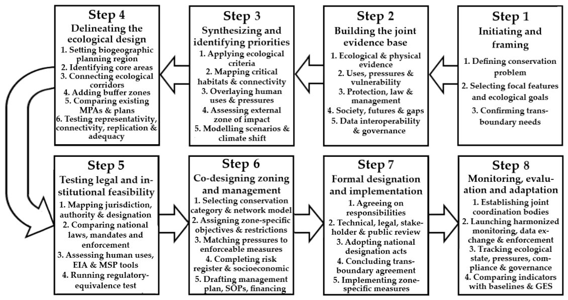
The final research step in developing a methodological model for establishing TMPAs involved systematic comparing and consolidating relevant propositions across established international frameworks. These elements were rendered to address the specific requirements of transboundary offshore conservation. The synthesis process yielded three principal outputs: (1) a set of transboundary ecological criteria, (2) a 20-component information framework (Table 2), and (3) a sequential pathway for designation, zoning, management, monitoring, and governance of TMPAs (Figure 1). The information framework ensured that the TMPA methodological model is comprehensive and adaptable, grounded in best practices from relevant global frameworks and tailored to the unique challenges of transboundary marine conservation.
Rigorous evidence appraisal, traceability, reproducibility, and auditability were integral to the content analysis underpinning the methodological model development. An evidence matrix linked each element to its supporting documentary sources. This matrix included the document identifier, thematic code, corresponding methodological component, source-quality assessment, and any identified limitations or uncertainties. Together with the database inventory, coding dictionary, and search records, the evidence matrix formed a comprehensive audit trail, enabling another researcher to reconstruct the analytical pathway from source to methodological output.
For each substantive methodological proposition, the analytical matrix retained the source identifier and the extracted supporting evidence. This approach ensured that the connection from source to code, analytical category, and final output could be transparently traced. We systematically documented any changes to codes or category definitions during iterative analysis, preserving the integrity and auditability of the final coding structure. Reproducibility was supported by four key auditable elements: a fixed 288-record database, explicit eligibility criteria for source inclusion, a predefined classification and coding structure, and a source-to-claim audit trail.

2.2. Conceptual Framework: From MPAs to TMPAs

We define a TMPA as either a single MPA that crosses two or more maritime jurisdictions or a set of formally designated MPAs located in neighboring jurisdictions that are managed as a coherent ecological unit through coordinated conservation objectives and management measures. In this study, broader MPA networks, marine ecoregions, migration corridors, and dynamic spatial management measures are regarded as supporting conservation mechanisms. The principal objective of a TMPA is to maintain biodiversity and ecological processes that extend across jurisdictional boundaries [47,48].
The ecological rationale for TMPAs is based on ecological connectivity. Many marine species and ecosystem processes transcend political boundaries through larval dispersal, seasonal migrations, trophic interactions, and hydrodynamic linkages. Consequently, conservation outcomes often depend on coordinated protection across multiple jurisdictions rather than on isolated protected sites [32]. TMPAs address this challenge by providing management arrangements that maintain ecological continuity across maritime zones.
Large-scale transboundary conservation is particularly important in marine environments where ecological processes frequently operate at spatial scales exceeding individual EEZs [32]. Such protection may be achieved through formally coordinated management plans or through agreements that harmonize conservation measures among states sharing ecologically connected habitats [47]. The legal basis for establishing TMPAs remains challenging, especially in EEZs and ABNJ, where jurisdictional fragmentation may impede conservation initiatives [49]. Nevertheless, even imperfect transboundary arrangements may provide greater conservation benefits than uncoordinated national approaches [14].
Because TMPAs function simultaneously as conservation instruments and governance arrangements, their effectiveness depends on the extent to which participating states align conservation objectives, legal frameworks, monitoring protocols, enforcement mechanisms, and management measures. As marine ecosystems contain fewer visible and stable boundaries than terrestrial environments, successful conservation frequently requires institutional cooperation across national borders [32]. Experiences from the Adriatic–Ionian region demonstrate that effective transboundary marine conservation depends on coordinated governance both vertically, across levels of administration, and horizontally, across sectors such as fisheries, shipping, energy, and nature conservation [50,51].
Hence, TMPAs are not only transboundary conservation areas but also cross-border governance mechanisms. Their success depends on the degree to which participating countries align conservation goals, legal mandates, monitoring standards, enforcement practices, and management measures. Aquatic environments have fewer natural boundaries than terrestrial ones, and those that exist are often difficult to detect from the surface [32]. Therefore, achieving robust transboundary marine conservation requires close cross-border collaboration, as demonstrated in the Adriatic–Ionian marine ecoregion [50]. It demands coordinated responses at vertical (local-to-global) and horizontal (across all sectors, including fisheries and extraction) levels [51,52].
Conservation strategies must be tailored to address specific threats to MMS within TMPAs, using appropriate regulations and transboundary zoning [22]. It is particularly important to manage the fisheries’ impacts. While MMS protection goals are acknowledged, the definition of specific targets is necessary [14]. For example, the Northern Adriatic TMPA shared by Italy, Slovenia, and Croatia is vital for conserving the common bottlenose dolphin (Tursiops truncatus) and the loggerhead sea turtle (Caretta caretta) [50].
In some cases, establishing a TMPA may not be the most effective solution [53]. For instance, reducing cetacean bycatch may be better achieved by enforcing gear-change legislation rather than by creating a TMPA [14]. However, many MMS exhibit strong site fidelity and occupy well-defined marine habitats implying the designation of a TMPA as a priority option [54]. These habitats and their connecting corridors are strong candidates for the TMPA designation.
Current MPA networks do not adequately support MMS conservation, and they must be expanded to include KBAs, often through dynamic management techniques such as time-and/or-area closures [22]. For example, the Natura 2000 network in EU waters has established over 100 SACs for the common bottlenose dolphin (Tursiops truncatus) and the harbor porpoise (Phocoena phocoena) [55]. Yet, these areas have been criticized for their small size [14].
Most existing MPAs were designated for purposes other than MMS conservation. While it is possible to assess how often MMS use MPAs, few studies have done so, and results are mixed [22]. Marine and flyway corridors are essential for providing passage, supporting connectivity among populations across international boundaries, and maximizing species’ potential ranges [56]. Stronger protection of these corridors is needed to prevent habitat loss, erosion, or fragmentation. Without this, species may be lost, or populations may become isolated and at risk.

2.3. Selection, Analysis, and Case-Based Validation Using the South Baltic Case Study

The South Baltic case study includes the offshore waters of Poland, Sweden, and Lithuania. It serves as a test of the proposed methodological model for establishing TMPAs. The principal objective was to assess the model’s operational applicability, internal consistency, and cross-jurisdictional functionality within a real-world transboundary marine environment. This case study was not intended as a before-and-after evaluation of conservation effectiveness because the proposed TMPA has not yet been implemented and no monitoring data are available. Therefore, the case study does not seek to demonstrate ecological outcomes or biological responses associated with TMPA designation.
Instead, the case study focuses on methodological validation by examining whether the conceptual and procedural elements developed through documentary analysis can be coherently applied in practice, generate spatially and institutionally interpretable outputs, and identify potential limitations or information gaps relevant to future implementation. The selection of the South Baltic area reflects the objective to test the framework under conditions where TMPA designation is both relevant and operationally challenging. The case study does not aim to provide a statistically representative sample of all European regional seas, but rather to evaluate the methodology’s robustness within a specific, complex transboundary context.
Therefore, this case study demonstrates the model’s internal coherence and practical applicability within a single European regional-sea context. It does not constitute external validation of ecological effectiveness, legal enforceability, stakeholder acceptance, economic efficiency, or broader transferability. The South Baltic case serves as a practical example of how the proposed TMPA methodological model can be applied across multiple jurisdictions. This application helps identify operational challenges that inform further refinement and broader implementation.
Five factors made the South Baltic area, spanning the maritime jurisdictions of Lithuania, Poland, and Sweden, suitable for this purpose. First, the area contains ecological features and MMS whose distributions extend across national maritime boundaries. Of particular significance is the Baltic Proper population of harbor porpoise (Phocoena phocoena), a genetically distinct and critically endangered group estimated at 400–500 individuals. Their breeding, feeding, and movement areas span the central and southern Baltic Sea, making conservation efforts ineffective if limited to isolated national sites.
Second, the study area includes both territorial waters and EEZs of three countries, enabling examination of how the methodology addresses jurisdictional fragmentation. Lithuania, Poland, and Sweden share major elements of international, EU, and HELCOM law, while retaining distinct domestic legislation, administrative structures, monitoring arrangements, and enforcement capacities. This mix allows for a robust test of regulatory compatibility and equivalence across different national systems.
Third, the region includes a variety of existing conservation sites and frameworks, including EU Natura 2000 sites, HELCOM MPAs, KBAs, and EBSAs, which could be consolidated into a broader transboundary network. The case therefore offers an opportunity to assess the model’s capacity to integrate pre-existing MPAs.
Fourth, the South Baltic is characterized by spatially overlapping and competing maritime activities such as commercial fishing, shipping, offshore wind-energy development, submarine infrastructure, and military operations. This setting provides a realistic context for evaluating the methodology’s effectiveness in balancing ecological priorities with cumulative and transboundary human pressures.
Fifth, sufficient ecological, spatial, legal, and planning information exists for the region, allowing for all principal stages of the TMPA framework to be applied. The area includes offshore zones like the Midsjö and Hoburg Banks, and while uncertainties regarding population distributions and temporal dynamics remain, the evidence base is strong enough to delineate boundaries and explicitly address such uncertainties.
The legal and institutional case comparison was delimited to Lithuania, Poland, and Sweden. Adjacent Latvian waters contribute ecologically to the proposed conservation network. However, Latvia was not included in the detailed comparative legal and institutional assessment. It was restricted to Lithuania, Poland, and Sweden to maintain a clearly defined three-country case. This delimitation prevents the ecological extent of the system from being confused with the scope of the legal comparison.
The South Baltic case study used a six-stage analytical procedure to validate a transboundary methodology for establishing a TMPA in the EEZs of Poland, Sweden, and Lithuania. The Baltic Proper harbor porpoise population was identified as the primary conservation target because of its conservation status, mobility, reliance on interconnected habitats, and exposure to transboundary pressures. The primary objectives were to maintain ecological connectivity, protect biodiversity, reduce cumulative anthropogenic impacts, and enhance coordinated monitoring.
Ecological and spatial data were consolidated within one unified geographical framework. This encompassed harbor porpoise occurrence, breeding and feeding grounds, seasonal movements, migration corridors, prey availability, habitat types, hydrographic features, existing MPAs, and jurisdictional boundaries. The integrated data enabled a preliminary spatial delineation of the proposed TMPA. It distinguished three functional zone types: core areas critical for breeding, calving, feeding, or repeated porpoise aggregation; ecological corridors connecting key habitats across national boundaries; and supporting areas that maintain prey resources, habitat quality, or other ecosystem processes.
Furthermore, we evaluated existing conservation designations against this ecological structure. Current and projected human activities, including shipping, fisheries, offshore wind farms, submarine cables, military operations, underwater noise, pollution, and eutrophication, were mapped and assessed for spatial distribution, intensity, seasonality, regulatory status, and interactions with conservation objectives. The primary aim was to evaluate the feasibility of differentiated and implementable management measures.
The study compared the legal and institutional systems of Lithuania, Poland, and Sweden. It focused on international law, EU directives, HELCOM obligations, and national legislation for protected areas and marine management. It examined competent authorities, MSP systems, monitoring, fisheries management, permitting, and enforcement. The aim was to assess if different national instruments could deliver equivalent conservation outcomes. The governance framework preserves national authority within each country’s territorial sea and EEZ while enabling coordinated transboundary management, monitoring, and data exchange, allowing joint stewardship of ecological units without transferring sovereignty.
Summing up, the South Baltic case study focused on whether the model could be operationalized in a real multi-jurisdictional context and determine key practical and institutional challenges. We tested the model across six analytical stages, each corresponding to a key step in TMPA planning:
  • Selection of a principal conservation feature (the Baltic Proper harbor porpoise, Phocoena phocoena) and definition of associated ecological objectives;
  • Spatial integration of ecological and human-use information, yielding a preliminary network design;
  • Differentiation of candidate spatial units into core areas, ecological corridors, and supporting areas;
  • Identification of major transboundary pressures and their relationship to management requirements;
  • Comparative assessment of national legal and institutional systems;
  • Formulation of a governance model based on preserving national jurisdiction while enabling transboundary management, monitoring, and evaluation.
The South Baltic case study does not provide data-based verification of ecological effectiveness or conservation outcomes. Demonstrating these outcomes would require formal designation, implementation of management measures, harmonized monitoring, and assessment of biological and governance indicators. None of these requirements was included in this validation exercise. Therefore, generalization from the South Baltic case is conceptual. It demonstrates that the approach can be operationalized in one European regional sea context but does not guarantee transferability to other regions or legal systems without further testing.

2.4. Source Appraisal, Evidence Hierarchy, and Treatment of Uncertainty

The methodological model for establishing TMPAs was developed through a systematic appraisal of a heterogeneous documentary knowledge base. Each source was appraised across four dimensions: (i) authority; (ii) methodological or documentary quality; (iii) relevance; and (iv) evidential strength. Authority evaluated the competence and institutional status of the issuing body or author in relation to the claim. For legal and jurisdictional propositions, we assigned the highest authority to primary legal sources such as international conventions, EU and national legislation, judicial decisions, and officially adopted regulatory instruments.
For ecological and empirical claims, we prioritized official monitoring data, regional scientific assessments, and peer-reviewed scientific research, and determined authority by the source’s provenance, mandate, and traceability. We also evaluated methodological or documentary quality by assessing the transparency and robustness of the methods or procedures used to generate information. For peer-reviewed scientific studies, we considered methodological transparency, empirical basis, data provenance, spatial and temporal coverage, analytical transparency, replication, and clear treatment of uncertainty. Legal and policy materials were assessed by formal status, currency, issuing authority, and jurisdiction. Relevance measured how directly a source addressed the analytical question.
Evidentiary strength was determined by the explicitness of the evidence. Monitoring results, binding legal provisions, formal institutional mandates, and adopted spatial plans were assigned greater weight than general recommendations. We maintained the evidence profile for each proposition transparently so that the strengths and weaknesses of each source were clearly reflected. Sources were grouped into five functional evidence levels, applied according to the nature of the proposition being evaluated (Table 1). This hierarchy was not used as an additive scoring system. Instead, it served as a claim-construction rule, ensuring each source contributed according to its evidentiary function.
The analysis explicitly recorded and incorporated uncertainty. Uncertainty was recognised in cases of incomplete, conflicting, outdated, or methodologically limited evidence; geographical or temporal gaps; inconsistent national classifications; indirect transfer of evidence from other marine regions; and model-dependent or preliminary assessments. Uncertainty was classified as follows: (i) evidence uncertainty; (ii) spatial uncertainty; (iii) temporal uncertainty; (iv) legal and institutional uncertainty. To mitigate these uncertainties, triangulation was used wherever feasible. Convergent evidence from independent and methodologically diverse sources increased confidence. We assigned greater weight to evidence that was more direct, authoritative, transparent, current, and geographically relevant.
For synthesis purposes, confidence in each proposition was expressed qualitatively as high, moderate, or low. High confidence required directly relevant primary or high-quality sources. Moderate confidence was assigned where evidence depended on a single principal source, partial extrapolation, incomplete coverage, or methodological deficiencies. Low confidence was assigned to indirect, incompletely documented, outdated, lower-authority, or contradicted evidence. These qualitative analyses did not represent statistical confidence intervals or probabilities. The procedure ensured that conclusions stayed within the available evidence and that the heterogeneous documentary material was not treated as an undifferentiated body of evidence.

2.5. Methodological Originality and Novelty of the Proposed Approach

The methodological originality and novelty claimed in this study stem from a creative, dedicated adaptation of marine conservation tenets, criteria, and legal notions. Established frameworks, including HELCOM, CBD EBSAs, IUCN protected-area categories, the KBA Standard, MSP instruments, and ecosystem-based management, provide the basic ecological and governance concepts. This study emphasizes operational integration, transboundary adaptation, and the systematic translation of these elements into a coherent methodological model for designating TMPAs, especially in offshore contexts. The novelty of this approach is integrative and operational, lying in the way these elements are reorganized and connected for transboundary application.
The central innovation is converting established, often nationally focused criteria and processes into explicitly transboundary decision rules. The methodology examines how each criterion must adapt when features, pressures, and management responsibilities cross maritime boundaries. For example, it assesses irreplaceability and uniqueness at the marine-ecoregion scale; links connectivity to compatible cross-border management; and incorporates adequacy by balancing ecological needs with regulatory feasibility across multiple jurisdictions. This approach treats political boundaries as governance variables alongside ecological connectivity principles.
A second key contribution integrates ecological evidence with legal and institutional feasibility through a regulatory equivalence test. The model examines whether different national measures can deliver comparable conservation outcomes for shared ecological features. Third, the methodology organizes the full TMPA designation sequence into a single executable workflow (see Figure 1). It integrates ecological site selection, spatial delineation, cumulative-pressure assessment, legal and institutional analysis, zoning, management planning, monitoring, enforcement, and adaptive review into one stepwise process.
Fourth, the methodology deploys a systematic information architecture for TMPA planning (see Table 2). Differences concerning terminology, categories, monitoring methods, and metadata are treated as methodological challenges to resolve during the designation process. This makes cross-jurisdictional data comparability an explicit analytical requirement. Fifth, the approach distinguishes core areas, corridors, and supporting zones, associating each with MMS conservation requirements. This ecological–legal–institutional coupling is central to the suggested approach.
Next, the methodology treats uncertainty and information gaps as outputs of the designation process. Where evidence is insufficient, the procedure applies the precautionary principle, conducts targeted data collection, continues monitoring, and adapts. This ensures TMPA design stays robust and auditable even under conditions of incomplete knowledge. Finally, the technique’s practical applicability is examined through its testing in the South Baltic area, the EEZs of Lithuania, Poland, and Sweden. Hence, the proposed approach generates a reproducible chain of intermediate, auditable outputs, presenting a practical pathway for TMPA designation.

3. Results

3.1. Delineation of TMPAs

3.1.1. Ecological Criteria for TMPA Designation

A scientifically credible, ecosystem-based TMPA should be designated using ecological criteria that reflect the spatial and functional characteristics of the marine ecosystem. Criteria from HELCOM, the CBD EBSA process, Important Marine Mammal Areas (IMMAs) designated by the IUCN Species Survival Commission, the KBA Standard, and marine World Heritage criteria provide useful foundations.
According to the HELCOM guidelines [48], a coastal or marine area of the Baltic Sea Region can be designated as a HELCOM MPA if it meets at least one of the criteria outlined below, if its proposed protection status corresponds to the IUCN protection categories, or if it is a designated Natura 2000 or MSFD site. We adapted these criteria to make them more applicable to transboundary offshore marine conservation in the Baltic Sea and broader European and global context.
1. Uniqueness or Rarity
Definition: An area is characterized by the presence of unique, rare, or endemic species, populations, or communities; unique, rare, or distinct habitats; unique or rare biogeographic qualities or representation of biogeographic types; and the existence of unique or unusual geological features.
Transboundary Perspective:
  • The uniqueness, rarity, or irreplaceability of marine habitats should be recognised at the scale of the marine ecoregion, irrespective of jurisdictional boundaries, to prevent artificial rarity resulting from political borders;
  • Transboundary irreplaceability implies that when a feature spans multiple jurisdictions, justification must be provided for why protection on only one side is inadequate;
  • Assessments of irreplaceability should account for potential loss of ecological function in addition to regional biodiversity;
  • Regionally unique offshore seabed features, as well as upwelling fronts, halocline-driven features that support distinct, often rare, and vulnerable communities should be given priority.
2. Significance of Life History Stages for Species
Definition: An area essential for the survival and persistence of a population, upholding ecological processes and life-support systems over short and long timeframes.
Transboundary Perspective:
  • Justification for TMPA designation requires comprehensive connectivity mapping to demonstrate how the transboundary habitat network or corridor links spawning, nursery, feeding, and wintering habitats, with particular attention to offshore and coastal coupling;
  • Effective marine conservation depends on coordinated transboundary efforts to implement seasonal and spatial closures for vulnerable MMS that correspond with reproductive periods, including the use of dynamic spatiotemporal zoning and management;
  • Offshore marine areas should be considered for TMPA designation if they are either repeatedly used over multiple years for feeding, spawning, nursery, or migration, or consistently develop conditions supporting these functions (such as oceanic fronts or stratification boundaries);
  • If a series of marine habitats critical to different life-cycle stages of a species extends across maritime boundaries, harmonized management measures, such as consistent seasonal closures and fishing gear regulations, are required among all countries sharing the TMPA, unless a documented rationale for asymmetrical measures exists;
  • Vertical connectivity, including pelagic and benthic coupling, as well as seasonal aggregation areas such as wintering, molting, and staging sites, must be considered in offshore TMPA designation, based on long-term species observation data.
3. Significance for Threatened or Endangered Species and Habitats
Definition: An area that provides habitat essential for the survival and recovery of endangered, threatened, or declining species, as determined by the extent of its geographical occurrence or the quality of habitat. This includes areas with significant assemblages of such species, or areas themselves classified as endangered or declining based on habitat extent or quality.
Transboundary Perspective:
  • A designated TMPA should encompass areas critical to recovery trajectories across all countries within the shared marine ecoregion. This includes not only current habitats or species presence but also sites where threat reduction is likely to result in species or habitat recovery;
  • Each country sharing the remaining extent of a threatened, endangered, or declining habitat or biotope must protect its proportionate share and agree upon a joint conservation target for the established TMPA;
  • Recovery pathway requirement: Each country sharing a threatened, endangered, or declining habitat or biotope must identify the primary pressures limiting offshore recovery and connect these to enforceable transboundary conservation measures;
  • Transboundary population monitoring and conservation of threatened, endangered, or declining species, based on distribution and abundance, must be grounded in clear population unit definitions. All participating countries must agree on whether the TMPA targets a regional population, subpopulation, or stock unit spanning the biogeographic region.
4. Vulnerability, Fragility, Sensitivity, and Slow Recovery
Definition: An area characterized by a relatively high proportion of sensitive habitats or species that are functionally fragile, meaning they are highly susceptible to degradation or depletion by human activities or natural events, or that exhibit slow recovery rates.
Transboundary Perspective:
  • Effective protection of sensitive transboundary habitats or MMS that are functionally fragile requires a joint, scientifically grounded mapping of threats and corresponding regulatory measures. This mapping should clarify regulatory responsibilities, including International Maritime Organization (IMO) measures for shipping, joint recommendations under the EU Common Fisheries Policy, national permits for offshore wind farms, and procedures for ABNJ, where applicable. Such coordination is a prerequisite for the feasibility of offshore TMPA designation;
  • Countries sharing fragile habitats should jointly assess the designated TMPA’s vulnerability to cumulative transboundary impacts and to pressures resulting from limited governance control, such as shipping outside territorial waters and the landing of offshore fish stocks;
  • Offshore TMPAs should account for the vertical vulnerability of the surface, water column, and seabed system, particularly in cases where different activities impact distinct layers;
  • When shipping risk constitutes a primary vulnerability, countries sharing the TMPA should pursue an IMO pathway that incorporates special protective measures derived from a PSSA status;
  • Justification for TMPA protection and zoning, such as the delineation of strict core and buffer zones, requires a jointly agreed and scientifically substantiated recovery time horizon for sensitive habitats or species: fast (1 to 5 years), medium (5 to 20 years), or slow (over 20 years).
5. Biological Diversity
Definition: Area that contains comparatively higher diversity of ecosystems, habitats, communities, or species, or has high genetic or functional diversity; an area that contains species important for maintaining ecosystem resilience, e.g., keystone species.
Transboundary Perspective:
  • The value of offshore biodiversity is frequently determined by ecological function and connectivity highlighting the importance of transboundary cooperation;
  • Offshore biodiversity should be assessed in relation to relevant offshore reference strata, including depth, salinity, and energy regime; it is particularly important for MMS and their transboundary migration corridors;
  • Transboundary conservation of biologically diverse marine areas should prioritize persistent transboundary drivers such as bathymetry, hydrography, and recurring productivity patterns extending beyond national territorial waters and EEZs;
  • Transboundary harmonization implies consistent habitat interpretation and classification across countries to avoid the “same habitat, different label” problem.
6. Naturalness
Definition: An area characterized by a high degree of naturalness due to low levels of human-induced disturbance or degradation. Ongoing economic activities must adhere to principles of sustainable use and align with IUCN protection categories.
Transboundary Perspective:
  • Offshore habitats are limited in extent but frequently extend to EEZs and ABNJ;
  • Effective management of natural seabed features requires basin-scale coordination, as ecological drivers and threats extend across maritime borders and EEZs;
  • In offshore TMPAs, naturalness is reflected in ecosystem integrity indicators such as intact food webs, reference areas with low human pressure, and climate refugia. These outcomes depend on effective transboundary regulation, not solely on geographic remoteness;
  • All countries sharing a TMPA must acknowledge that offshore areas may appear natural but can be affected by transboundary pressures, and must jointly establish a baseline for assessment;
  • All countries sharing a TMPA must also reach consensus on reference zones, indicators, and values to enable joint long-term assessment and monitoring of naturalness status and its changes, using mapped pressure intensity and seabed condition as a basis.
7. Coherence at MPA network level
The selection and designation of new HELCOM MPAs must align with the HELCOM objective of establishing an ecologically coherent MPA network in the Baltic Sea. To this end, HELCOM has established four criteria for assessing network coherence: representativity, connectivity, replication, and adequacy. These criteria must be integrated into the TMPA designation process.
7.1. Representativity
Definition: Representativity is achieved when a network reflects maritime subdivisions, encompassing a full spectrum of ecosystems, including both biotic and habitat diversity. This concept also relates to ecological integrity, defined as the extent to which an area, independently or together with other MPAs, encompasses a complete ecosystem.
Transboundary Perspective:
  • Transboundary offshore representativity means using the scale of biogeographic provinces and offshore seascapes to cover offshore banks, basins, slopes, and pelagic regimes, such as fronts and stratification zones, beyond littoral habitat types;
  • All countries sharing the marine ecoregion should treat representativity as achieved when a TMPA or an MPA network covers the full offshore environmental gradient defined by depth, seabed, stratification, and oxygen regimes across the entire transboundary system;
  • Representativity of an offshore network spanning different biogeographic subdivisions of the marine ecoregion should include water-column features such as pelagic habitats that are unique or rare, as conservation targets;
  • In transboundary contexts, all relevant countries must ensure that all key ecoregion’s features are represented despite the borders.
7.2. Connectivity and spacing of HELCOM MPAs
Definition: Connectivity in network design refers to establishing linkages that enable MPAs to benefit from exchanges of larvae and species, as well as functional connections with other network sites. Considerations should include ocean currents, gyres, physical bottlenecks, migration routes, species dispersal, detritus movement, and other functional linkages. Isolated sites may also be incorporated.
Transboundary Perspective:
  • Connectivity must be assessed with transboundary mechanisms: larval dispersal, migration corridors, stepping-stones, and currents or gyres that cross EEZ lines;
  • Transboundary offshore larval dispersal (currents), migration corridors, and stepping-stone spacing need to consider vertical and seasonal connectivity (timed protections);
  • The countries sharing a marine ecoregion should follow the “connectivity to management” principle: where a feature spans borders, the network must include compatible measures in all territorial waters and EEZs or clearly justified alternatives;
  • Any designation of an offshore TMPA requires model-based connectivity evidence appropriate to offshore systems, including larval dispersal, adult movement, genetic structure, migratory corridors, or stepping-stone logic for migratory species.
7.3. Replication
Definition: Replication of ecological features necessitates that multiple sites within a biogeographic area contain examples of a given feature. In this context, “features” refer to naturally occurring species, habitats, and ecological processes in the biogeographic area.
Transboundary Perspective:
  • Transboundary replication rule: countries sharing the marine ecoregion should avoid single-country replication that leaves other jurisdictions unprotected for the same feature; replication should be spatially independent to avoid governance risk;
  • It means that replication is not satisfied by multiple sites within a single EEZ if the ecological feature is transboundary or the pressure regime is shared;
  • The countries establishing a TMPA should also aim to replicate key ecological functions including spawning sites, foraging hotspots, and refugia across jurisdictions to hedge against localized collapse, accidents, or regulatory changes;
  • The countries sharing a marine ecoregion should also align with the UN CBD EBSA-type process framing (productivity, life-history importance, vulnerability).
7.4. Adequacy
Definition: Adequate and viable sites are those that possess sufficient size and protection to maintain the ecological viability and integrity of the features for which they are designated. Adequacy and viability depend on factors such as site size, shape, buffer zones, prevailing feature persistence threats, surrounding environment, physical constraints, scale of ecological features and processes, and spillover or compactness.
Transboundary Perspective:
  • The countries sharing a marine ecoregion must make the concepts of adequacy and viability explicit: the site designated as a TMPA is adequate only if enforcement and compliance tools exist (common monitoring, controls, protocols, data sharing, etc.);
  • Designation of a TMPA requires replacing minimum-size guidance with feature-based sizing offshore to meet transboundary adequacy and viability requirements;
  • Countries sharing the TMPA require an “adequacy vs pressures” statement to show that chosen measures reduce the pressures enough to keep adequacy and viability.

3.1.2. Delineation of Critical Transboundary Marine Habitats

Building on this knowledge, establishing TMPAs requires harmonized governance among neighboring countries. Only then it could effectively protect critical marine habitats and MMS. Hence, the identification and delineation of critical habitats for TMPAs is essential for this purpose. It is a multi-step process that integrates ecological, social, and governance perspectives. Based on the extensive literature analysis, we identified a series of steps to delineate critical transboundary marine habitats for TMPAs.
First, following the HELCOM Guidelines [48], the planners should compile detailed catalogues of habitats and species recognized as conservation priorities under international conventions, regional conventions (HELCOM, OSPAR, Barcelona, Nairobi), and EU Directives, if relevant. Once baseline knowledge is established, attention shifts to the identification and characterization of habitats essential for marine megafauna and other key MMS. It implies systematic mapping of areas used for feeding, breeding, calving, nursing, socializing, and migration, noting that habitat boundaries may change with seasonal cycles or as populations recover [14].
To be effective in conserving migratory cetaceans, TMPAs must also protect prime fish-rearing habitats, productive upwellings, and other “ecological factories” [50]. Therefore, the mapping process should also cover marine areas that support the broader food web. Detailed charting of migration routes reveals corridors connecting populations across geopolitical boundaries. Prioritization and delineation follow, based on the understanding that not all habitats can receive equal levels of protection [14,22].
Geographical Information System (GIS) and advanced decision-support tools are essential for assessing ecological value, connectivity, vulnerability, and representativeness. Existing networks of MPAs and KBAs [7] are overlaid and compared, revealing gaps in shared regions that require attention. However, identifying priority zones remains incomplete without a comprehensive assessment of the threats and pressures they face. The cumulative effects of these pressures frequently transgress national boundaries.
After critical habitats are identified and threats assessed, the final step in this stage is to delineate the TMPA [51]. This phase requires negotiation and consensus-building among neighboring countries. The goal is to determine spatial dimensions of critical habitats. The planning region must be based on biogeographic instead of political boundaries [57]. Thus, the TMPAs for MMS may be established in the EEZs of neighboring countries as a concerted effort.
Such a concerted effort could enable permanent prohibition of the exploitation of MMS, regardless of optimum utilization objectives [58]. However, when MMS conservation interests clash with fisheries interests, the likelihood of overexploitation risks increases progressively with each additional EEZ the stock spans [59]. Therefore, despite the apparent need, the MSP process in the EU has hitherto focused on strengthening cross-border cooperation rather than on joint enforcement of fisheries regulatory plans [39].
In sum, ecosystem-based management is essential for balancing marine conservation and fisheries goals [14]. Selecting a transboundary region to establish a TMPA or a transboundary network of offshore MPAs requires a coherent dataset on MMS and critical habitats. Essential data are available from oceanographic and biological datasets such as OBIS (Ocean Biogeographic Information System), Seabed 2030, the Marine Regions database, Global Fishing Watch, and the MPA Atlas of UNEP-WCMC (UN Environmental Program and World Conservation Monitoring Centre). The mapping helps clarify how the criteria for establishing a TMPA are applied spatially by mapping migratory corridors, shared ecosystems, and biodiversity hotspots.

3.2. Methodological Pathway to Establish TMPAs

3.2.1. Defining and Framing the Conservation Problem and Objectives

The establishment of a TMPA should follow a step-wise approach (Figure 1). The first step is defining the conservation problem. Countries must determine whether the primary purpose is marine biodiversity conservation, critical habitat restoration, MMS protection, fish stock recovery, climate adaptation, cultural preservation, or multiple-use ecosystem-based planning and management. In many TMPA contexts, these goals will overlap. However, without clearly defined objectives, management effectiveness cannot be assessed. Therefore, a broad array of stakeholders should be involved in the dialogue and in defining the conservation problem and objectives.
Effective marine biodiversity conservation necessitates an ecosystem-based perspective that accounts for the complex interactions between human activities and marine ecosystems. Public participation is a critical component of the ecosystem approach to marine environmental protection and management [60,61,62]. This approach requires reconciling potentially conflicting stakeholder interests and implies cross-sectoral cooperation in defining the conservation problem and objectives [63,64].
According to the EC, ecosystem management should be adaptive and responsive to environmental diversity and variability [65]. Therefore, all participating countries should collaboratively develop and formally adopt the management plan to ensure recognition and enforceability across relevant jurisdictions. The next step is to compile the legal and institutional baseline, starting with an integrated planning framework. It must align objectives, management measures, and monitoring across local, national, and international governance levels. This process includes mapping relevant international treaties, regional conventions, EU directives (where applicable), national laws, MSP instruments, fisheries regimes, shipping regulations, and EIA procedures.
A legal matrix should identify jurisdictional authority, management mandates, enforcement powers, dispute-resolution mechanisms, and gaps in legal interoperability. This approach enhances the plan’s suitability for interagency coordination and facilitates cooperation among stakeholders from all participating countries. Planners must recognize that each nation involved in establishing a TMPA has distinct social, economic, political, and environmental priorities. Where feasible, each country’s national legal framework should incorporate the authority to establish and enforce the plan, and reference it in relevant international agreements.

3.2.2. Comprehensive Collection of Information

Kenchington and Kelleher [66] emphasize that collecting of information for a future TMPA is most effective when a joint central agency coordinates it in collaboration with consultants and research institutions from each participating country. This collaborative approach underpins the development of joint agreements, which are essential to effectively developing and governing a TMPA. The pressures and effects of human activities in the future TMPA, and their interactions with external areas must be well understood and prioritized through transparent, established methods [51]. This prioritization process involves analyzing quantitative data to determine optimal locations for conservation investments [50].
Comprehensive understanding of natural and anthropogenic processes and their consequences can be achieved by integrating both historical and recent data with empirical or dynamic modelling, where feasible [67]. The desired “favorable conservation status” must be clearly and objectively defined [68]. For example, Touron-Gardic et al. [7] detail the assembly of a comprehensive MPA inventory across seven countries for the IUCN West Africa program. They found that essential discrepancies between the World Database on Protected and Conserved Areas (WDPCA) and national censuses of the MPAs persisted due to variations in reporting standards, delays in data updates, and differences in inclusion criteria and interpretation.
The key information components necessary for establishing a TMPA and standardized methods for its collection are provided in Table 2. The structure of Table 2 synthesizes the information from [32,52,69,70]. The table suggests that the most important issue is not merely collecting more information, but ensuring that information from different jurisdictions is comparable and interoperable.
Lascelles et al. [22] emphasize that data on MMS distribution, abundance, behavior, and threats should directly inform the design of effective conservation regimes within TMPAs (Figure 1). Integrating such data into decision-making processes, particularly those governing fisheries, shipping, and offshore energy facilities, ensures that management interventions are evidence-based and responsive to the needs of all involved countries (Table 2). Hoyt [14] recommends the commissioning of coordinated field surveys for cetaceans and other MMS throughout the transboundary ecoregion. Such surveys should aim to:
  • Determine abundance and population trends;
  • Map distribution patterns, including local movements, migrations, and seasonal shifts, to guide area management;
  • Assess behavior, including hunting and feeding preferences;
  • Identify and delineate critical habitats such as feeding, mating, calving, and socialization areas, as well as culturally important sites;
  • Monitor populations year-round, ideally for several years, to assess site fidelity and find temporal shifts in area use that inform management.
Kenchington & Kelleher [66] suggest three guiding objectives for investigations:
  • Compiling existing information from publications, maps, and reports across jurisdictions;
  • Identifying key issues that require protection or management on a transboundary scale;
  • Determining information gaps regarding resources, uses, and impacts to inform the design of practical, shared management measures.
TMPA planning needs pragmatism toward data gaps (Figure 1). Collaboration encourages moving ahead with management planning using the best available information. Partners should also identify and prioritize key gaps for future action (Table 2). Regular, joint evaluation of management effectiveness helps reveal which knowledge gaps matter most for conservation and which can be filled over time through targeted research.

3.2.3. Advanced Information Synthesis

The application of GIS overlay mapping for data synthesis facilitates the analysis of spatial relationships among seabed topography, bathymetry, geology, oceanographic conditions such as water movement and temperature, biological factors, biodiversity values, ecological processes, human activities, threats, conflict identification, jurisdictional boundaries, and scenario modelling (Table 2). This approach is particularly relevant in the context of external threats such as climate change. GIS overlay techniques can integrate diverse datasets to illustrate specific support systems for species or ecosystems, for example, by combining data on MMS migration corridors [52].
GIS is frequently employed to consolidate and visualize spatial data that are otherwise challenging to represent. Overlay maps should delineate the TMPA’s proposed functional zones according to ecological features, human activities, and identified threats (Figure 1). Assigning market values to marine ecosystem services can help evaluate the impacts of competing uses, including conservation. This approach enables informed decision-making that balances human uses with conservation objectives [70]. When implementing GIS and simulation modelling tools, it is essential to ensure that mapping techniques and data-sharing protocols are compatible across national boundaries. Hence, establishing transboundary agreements on shared standards and workflows is necessary (Figure 1).
Lascelles [22] demonstrated various simulation modelling techniques to predict species distributions in areas with uneven survey coverage. Simulation modelling also guides the design of TMPA to withstand future climate shifts. For MMS that cross borders, it is crucial to focus on dynamic ocean features, such as fronts and upwelling zones, which can shift in time and space (Table 2). However, critical data necessary for simulation modelling may remain unavailable or incomplete.
Therefore, fusing Artificial Intelligence (AI) with automated data collection, transfer, and processing can alleviate persistent monitoring bottlenecks and provide conservation managers with more timely information, enhancing adaptive decision-making [71]. Isabelle & Westerlund [72] discuss AI-driven opportunities in species protection, monitoring, prediction, and the detection of illegal or harmful resource use, positioning these applications within the wider context of achieving SDG 14. Cortes [73] describes an expanding coastal and marine research landscape characterized by a move from traditional environmental sensing to instantaneous monitoring and predictive modelling. Palarimath [74] further shows how AI can extract ecological information from image, acoustic, spatial, and environmental data streams at scales impossible through manual interpretation.
A second frontier entails integrating AI with passive acoustic monitoring, animal telemetry, satellite observations, autonomous platforms, environmental sensor networks, and vessel-tracking data [75,76]. Bakker [77] conceptualizes this advancement as part of the emergence of “Smart Oceans” and AI-enabled mobile MPAs, in which conservation boundaries and regulatory provisions can adapt as MMS move or as environmental conditions change. In this context, AI facilitates a transition to conservation regimes that dynamically adjust to the evolving marine “movescape” under climate change [77]. A third frontier is the advancement of Explainable Artificial Intelligence (XAI). XAI methods are particularly important when computational outputs inform high-stakes decisions such as MPA designation, fisheries regulation, restoration prioritization or MSP [78].

3.3. Finalizing the Management Plan for a TMPA

3.3.1. Selecting the Appropriate Conservation Category

The next step is selecting the appropriate conservation category and zoning model for TMPAs (Figure 1). The Law of the Sea provides more than 1000 instruments and more than 300 regulations concerning marine conservation [79]. Despite the extensive range of instruments and regulations, effective TMPA conservation depends on shared expectations that extend beyond the formalization of international agreements [80].
A single IUCN category may be unsuitable for large TMPAs with multiple uses. A zoned model may be preferable, combining highly protected core areas with surrounding buffer zones and sustainable use areas (Table 1). Sensitive habitats, spawning grounds, and MMS hotspots may require Category Ia or Category IV protection, while broader seascape-scale management may align with Category V or VI [48].
For TMPAs, the IUCN category should remain consistent across all participating countries to ensure transboundary coherence of the conservation regime. Its objectives should be aligned with the standard IUCN objectives [81]. The zoning enables a TMPA to span territorial waters and EEZs provided that at least 75% of the TMPA is subject to the same management objectives [82]. An alternative approach is to establish a transboundary network of smaller MPAs ensuring coherent regulations and consistent IUCN categorization for each MPA. However, assignment to a category does not reflect management effectiveness. The category specifies the intended purpose of the site, not its operational management [81,82,83].
Murphy et al. [10] argue that establishing a protected seascape (IUCN Category V) offers an optimal cross-border conservation regime for a TMPA, assuming political and financial institutions support and adopt it. The Seascape approach provides a foundation for robust, resilient, and equitable transboundary management [84]. This approach directly supports the ‘30 by 30’ objective. Ellet et al. [85] concur: Seascapes are large, multi-use marine areas, scientifically and strategically defined, in which government authorities, private organizations, and other stakeholders cooperate to conserve the diversity and abundance of marine life and promote human well-being.
Marine peace parks promote international cooperation and peace-building by transcending political boundaries to protect shared marine ecosystems [86]. Both the seascape and marine peace park approaches encourage states to collaborate on marine conservation, particularly in politically sensitive or resource-limited border regions [87]. The effectiveness of these initiatives, however, relies on robust governance frameworks, active stakeholder engagement, sustained political commitment, and continuous research and adaptive management to address region-specific challenges [88].

3.3.2. Management Zoning

Zoning serves as the primary tool for translating conservation objectives of TMPAs into actionable, geographically defined management measures (Figure 1). In cross-border contexts, zoning must address ecological processes that traverse jurisdictions, while harmonizing differences in national laws, planning systems, data standards, enforcement capacities, and stakeholder interests (Table 2). An effective methodology is ecosystem-based, evidence-driven, participatory, legally robust, digitally reproducible, and adaptive [89]. The initial phase requires the definition of clear management objectives for the TMPA and operational objectives for each zone (Figure 1).
Each objective should be translated into spatially explicit criteria and targets that address ecological and socio-economic factors such as biodiversity, connectivity, vulnerability, fishing dependence, and enforcement feasibility (Figure 1). Achieving joint agreement on objectives and criteria among participating states is essential to prevent incompatible priorities [50]. A comprehensive and harmonized geospatial database that integrates national and international data sources should form the foundation of the zoning process (Table 2). Particular attention must be given to critical habitats and anthropogenic pressures [90].
Functional zone boundaries should be assessed for both ecological effectiveness and operational feasibility. They must consider habitat integrity, connectivity, potential displacement of human uses, and enforceability [50]. They must also prioritize ecological thresholds rather than political or economic convenience. Gradual transitions between zones support ecological connectivity and compliance (Table 2). Finally, legal and technical experts convert draft zones into enforceable cross-border boundaries using precise geographic coordinates and interoperable digital datasets [91]. Achieving regulatory equivalence between countries is necessary to ensure comparable levels of protection [92]. Zoning plans must be part of the TMPA management plans and periodically reviewed.

3.3.3. Delivery of a Joint Management Plan for a TMPA

The final step in designing a TMPA is the delivery of a joint management plan. It is the principal mechanism through which the conservation objectives are translated into coordinated operational action (Figure 1). Such a plan should affirm conservation objectives, management measures, monitoring indicators, enforcement responsibilities, financing arrangements, adaptive management procedures, and review mechanisms. It should also establish GES as a long-term management benchmark (Table 2). A TMPA management plan must reconcile conservation needs extending across political boundaries with differences in legislation, administrative systems, institutional capacities, financing arrangements, and monitoring practices.
The management plan must also account for stakeholder interests across all participating countries. Adoption of concepts such as critical habitat, ecosystem-based management, transboundary conservation regimes, zoning, and networks facilitates effective TMPA conservation (Table 2). To operationalize these concepts, the proposed structure incorporates core TMPA requirements, with an emphasis on joint governance, legal harmonization, and ecological connectivity. This structure is informed by a broad range of sources [12,13,14,22,32,48,51,52,62,66,70,82,93].
Management measures, derived from agreed objectives and baseline assessments, must be tailored to site-specific requirements while maintaining consistency across borders. A comprehensive TMPA management plan should be supported by detailed Standard Operating Procedures (SOPs) for surveillance, incident response, permitting, monitoring, and enforcement. A joint monitoring program evaluates both ecological condition and management effectiveness (Table 2). It uses indicators linked to conservation objectives, including ecosystem states, human pressures, and management responses. Each indicator is defined by specific metrics, baselines, targets, triggers, sampling designs, and reporting formats. It ensures systematic data collection and adaptive management.
Adaptive management is implemented through a formal cycle of execution, monitoring, evaluation, learning, and revision. Predetermined triggers prompt reviews when objectives are unmet, conditions change, or new threats arise. The management plan is updated to reflect new evidence and evolving circumstances (Figure 1).
Stakeholder engagement is integrated throughout all stages, utilizing public consultations, workshops, focus groups, participatory mapping, and advisory forums. Transparent documentation and structured conflict resolution processes enhance legitimacy and foster compliance. The draft management plan undergoes technical, legal, and public review before finalization and approval. Last but not least, a smooth cross-border implementation is ensured by a joint matrix, which specifies responsibilities, outputs, deadlines, and dependencies (Figure 1).

3.4. Participatory Planning and Governance

3.4.1. Risk and Threat Management and TMPA Governance

Ensuring the long-term sustainability and resilience of a TMPA requires implementing comprehensive cross-border measures to systematically identify, analyze, prioritize, and mitigate risks and threats (Figure 1). A comprehensive risk register should be developed to encompass environmental (climate change, invasive species, pollution), governance (jurisdictional conflict, enforcement gaps), socio-economic (livelihood impacts, equity), and operational (funding, coordination) risks (Table 2).
Each risk must be evaluated for likelihood and potential impact using risk matrices, scenario analysis, spatial analysis, and temporal differentiation between emerging and long-term risks. Risk tolerance thresholds are established through stakeholder consultation, and cost–benefit analyses should inform the selection of mitigation measures. Effective governance of a TMPA relies on the preparedness of each country and the adequacy of its institutional and legal frameworks to designate an MPA. It must be done within a coherent transboundary network or to establish a TMPA spanning jurisdictions [94].
Legal equivalence may be compromised if participating countries have divergent legal frameworks [13]. For example, in Germany, a management plan for MPAs is not legally binding [95]. The legal tools regulating TMPA governance can be categorized as follows (adapted from [96]):
  • Application—includes the legal tools that define the subject matter and jurisdictional limits of the MPA legal framework;
  • Governance—legal tools to ensure that the MPA management overall is scientifically and technically sound;
  • Protection and Conservation—legal tools to protect MPAs and their natural resources from damage, destruction, and unwanted exploitation;
  • Surveillance and Control—practices define how the MPA conservation includes surveillance and control, such as marine ecosystem monitoring and MSP parameters;
  • Restrictions and Prohibitions—focus on general and specific activities which the law prohibits in MPAs;
  • Enforcement—focuses on general or specific authorities over MPAs, including their powers to investigate, collaborate, collect, and share information, as well as the crimes defined and the penalties that apply for violations;
  • Violations—standards and procedures that hold any party to a crime in MPAs responsible for their actions, including those standards and procedures found in related civil, administrative, and criminal legislation.
The effectiveness of marine conservation is influenced by the degree of asymmetry between countries [47]. Non-compliance or inadequate management by one country can undermine the conservation efforts of others. For instance, equitable international cooperation among all countries and authorities along the same migration route is essential for achieving successful MMS conservation outcomes [97]. At both global and regional levels, legal instruments such as Multilateral Environmental Agreements (MEAs) prioritize conservation actions for listed species [98].
In certain cases, dynamic zoning can effectively minimize conflicts between human activities and conservation objectives [52]. For instance, while industrial fishing in critical spawning grounds may appear insurmountable, implementing MMS protection during the spawning season and permitting fishing during the remainder of the year can be mutually beneficial [99]. Comprehensive knowledge of MMS distribution and abundance is therefore essential for establishing conservation priorities. However, acquiring these data is challenging due to the high cost and complexity of necessary surveys [100].

3.4.2. Transboundary Enforcement of the TMPA Management Plan

Effective transboundary enforcement is essential for the success of a TMPA (Figure 1). Enforcement objectives should be directly aligned with the TMPA’s conservation goals and legal mandates, and supported by a unified enforcement policy to ensure compliance with both national and international regulations. SOPs should be established for joint enforcement activities, data sharing, and promote cooperation among environmental agencies, coast guards, and fisheries authorities. Enforcement tools may include education, warnings, penalties, and incentives, with clearly defined powers assigned to enforcement personnel.

3.4.3. Ensuring Public Participation in the TMPA Management

Guaranteeing broad participatory rights in environmental protection is now a standard in Europe. The deteriorating state of the environment can negatively impact human rights related to the natural environment [101,102]. Therefore, access to environmental information and opportunities for public participation are key conditions for justice in environmental protection [103]. Second, the high costs and relatively low efficiency of authorities mean that ensuring participatory rights fosters greater public involvement in environmental protection [104].
Public involvement can, in some cases, substitute for certain state functions, particularly in monitoring and information gathering [105]. Access to environmental information is essential for meaningful participation in protection efforts [106]. As early as 1922, Jan Gwalbert Pawlikowski asserted that neither legislation nor state administration can protect the environment without societal support and involvement [107]. This principle was later affirmed and given normative status as soft law in Principle 10 of the Rio de Janeiro Declaration. However, it is still debatable, whether this thesis is equally applicable to marine environmental protection [106].
In legal conservation doctrine, public participation is the highest form of social engagement [108]. The Aarhus Convention guarantees access to environmental information and public participation in environmental decisions [109]. It guarantees three main participatory rights: access to environmental information (Articles 4–6), participation in environmental decision-making (Articles 6–8), and the right to a court in environmental protection matters (Article 9) [110]. EU law ensures participatory rights that form the constitutional basis for protection of the marine environment [55,79,111].
For instance, the legal nature of the Baltic Sea region justifies numerous guarantees of participatory human rights in protecting the Baltic Sea’s marine environment [106]. It results from the increasingly widespread adoption of the ecosystem approach in environmental protection [62]. In the chapter “Raising awareness and capacity building”, the Joint Baltic Sea Action Plan recommends that states and regional and local governments promote public participation in decision-making. This chapter also provides for activities in the field of raising environmental awareness and environmental education [112].
The EU Water Framework Directive (Directive 2000/60/EC, WFD) was among the first regulations to combine these concepts and significantly affected the Baltic Sea’s environmental conditions [113]. The Directive’s Article 14 requires that key tools for implementing the ecosystem approach in water management be available for public comment. The Directive also extends consultation periods: three years for river basin management plans, two years for interim reviews, and one year for draft water basin management plans. Poland’s similar regulation was criticized for allowing only 30 days for participation, viewed as insufficient for effective input [114].

3.4.4. Adaptive Cross-Border Management of the TMPA

Adaptive management is a structured and iterative process for decision-making under uncertainty [115]. The objective of cross-border adaptive management for TMPAs is fourfold: (i) integrate monitoring results into a cyclical process; (ii) update management plan objectives as new information becomes available; (iii) communicate outcomes to all partners and stakeholders to foster support and enable adaptive responses; (iv) utilize ongoing scientific research to refine management approaches, indicators, and actions. However, adaptive management may lack clearly defined experimental controls and endpoints, and no single indicator can fully represent ecosystem health [116].
Therefore, the cross-border adaptive management to the TMPA needs to focus on specific objectives that depend on the area’s conservation needs [117]. It requires a fundamental understanding of the social and political contexts and specific biophysical features [118]. Without clear objectives, it becomes impossible to decide which stakeholder groups are relevant for the TMPA adaptive management in question [119]. Hence, it is very important that the objectives are well-founded and defined [120].
The overall goal for a wider network of TMPAs must be to establish a representative, connected, and adequately protected marine area (ideally, 30% of the marine ecoregion area) [121]. In the EU case, for the marine habitats listed in Annex I of the EU Habitat Directive (Directive 92/43/EEC) we argue that the conditions imply: (1) the extent and range of the habitat is maintained or increased over time and (2) the populations of the consistent species of the habitat are maintained over time.
GES is the desired long-term state for the marine environment. It means ecological processes, habitats, and species are healthy, resilient, and sustainable [122]. It is the benchmark for marine environmental quality as defined by international and regional agreements. Achieving and maintaining GES requires clear objectives and measurable indicators. Ecosystem-based management must align with scientific understanding and policy frameworks. This is essential for TMPAs, where cooperation and harmonized monitoring are vital for success [123].

3.5. Case Study: Designation of the South Baltic TMPA

3.5.1. Approach

To evaluate the operational applicability and diagnostic capacity of the proposed TMPA designation methodology, we implemented its principal analytical components in a South Baltic case study encompassing the maritime jurisdictions of Lithuania, Poland, and Sweden. From an ecological perspective, adjacent Latvian waters may contribute to this marine conservation network. However, the legal and institutional comparison undertaken in this case study is limited to Lithuania, Poland, and Sweden.
The case study applies essential parts of the proposed TMPA designation methodology through six interrelated analytical steps:
  • Identification of principal conservation features and associated ecological objectives;
  • Compilation and integration of ecological and spatial data;
  • Delineation of ecological boundaries and functional zones of the TMPA;
  • Assessment of projected human uses and transboundary human pressures;
  • Comparative examination of national legislation, competent authorities, and regulatory criteria;
  • Analysis of maritime jurisdictions, sovereign rights, and possible governance arrangements.
The case study is based on a structured review of scientific literature, from seminal works by Hoyt [14], Kelleher [82], and Agardy [124] to recent publications by Dallison et al. [24] and Wenzel et al. [81], as well as legal instruments, policy and MSP documents, biodiversity assessments, monitoring reports, and regional conservation databases. Digital spatial analysis overlays ecological data, maritime boundaries, existing MPAs, shipping routes, fishing grounds, offshore energy zones, and oceanographic characteristics.

3.5.2. Ecological Basis for Designation

The main conservation goal of the proposed South Baltic TMPA is to support the recovery and enduring viability of the Baltic Proper harbor porpoise (Phocoena phocoena) population. This species was selected because it is listed in Annex II of the EU Habitat Directive as one of the few MMS of Community importance. It is highly mobile. It regularly crosses national maritime boundaries, depends on connected breeding and feeding habitats and migratory corridors, and is exposed to pressures that no single Baltic Sea country can address effectively.
The Baltic Proper harbor porpoise population is genetically distinct from the more numerous Belt Sea population in the western Baltic Sea, Kattegat, and Belt Seas. It is estimated at only 400–500 individuals and is classified as Critically Endangered in HELCOM and international assessments. Its principal threats include incidental capture in fishing gear, underwater noise, reduced prey availability, habitat degradation, pollution, and disturbance from offshore construction and maritime traffic.
Monitoring conducted through the international SAMBAH II project identified the Mid-Sea Banks, including the Midsjö and Hoburg Banks southeast of Öland Island in Swedish territorial waters and the EEZ, as important breeding, calving, and feeding areas. Acoustic observations indicate seasonal concentrations in these areas, particularly between May and December. Outside the breeding season, individuals disperse more widely through the central and southern Baltic Sea, showing that conservation measures must protect core reproductive habitats, movement corridors, and seasonally used feeding areas (Figure 2).
The harbor porpoise therefore functions both as a direct conservation target and as an umbrella or indicator species. Measures designed to protect its full life cycle may also benefit fish populations, especially the declining Eastern Baltic cod (Gadus morhua callarias), benthic habitats, and seabirds, e.g., the long-tailed duck (Clangula hyemalis), also included into the Annex II of the Habitat Directive and wider ecological processes. Declining cod and sprat stocks, eutrophication, climate-related ecosystem change, and the deterioration of offshore habitats further support the need for an ecosystem-based management.
Accordingly, the ecological objective of the TMPA is to establish a connected and viable transboundary ecological network of offshore habitats that support breeding, feeding, migration, and seasonal dispersal of the Baltic Proper population of harbor porpoise. Complementary objectives are the protection of associated biodiversity, the maintenance of ecosystem connectivity, the reduction in cumulative transboundary anthropogenic pressures, and the improvement in South Baltic-wide biodiversity monitoring.

3.5.3. Preliminary TMPA Boundary Demarcation and Zoning

We began the TMPA boundary demarcation process by identifying ecological features that transgress existing jurisdictional divisions. Spatial data on harbor porpoise occurrence, breeding areas, feeding grounds, migration routes, prey distribution, seabed habitats, hydrographic conditions, and ecological connectivity were combined in a common geospatial framework (Figure 3). A zoned or network-based model may be more appropriate because it can reduce administrative duplication and facilitate implementation through legal tools available under national, regional (HELCOM), and EU law.
The analysis identified three key types and areas of functional zones:
  • Core areas in which breeding, calving, feeding, or repeated seasonal aggregation occurs (SE-1, SE-2, and PL-1 in Figure 3);
  • Ecological corridors connecting core areas across national maritime boundaries (LT-3, LV-2, PL-2, and SE-3);
  • Supporting areas that maintain prey availability, habitat quality, and essential ecosystem processes (LT-1, LT-2, and LV-1).
The initial ecological boundary was subsequently compared with existing Natura 2000 sites, HELCOM MPAs, national MPAs, MSP documents, KBAs, EBSAs, and other conservation designations. The proposed TMPA should incorporate and connect existing protected sites (SE-1—the Midsjö and Hoburg Banks in Sweden, which are marine Natura 2000 sites, KBAs, and HELCOM MPAs, as well as LT-1, LT-2, and LV-1—the Klaipeda–Ventspils Plateau is a cross-border EBSA, a KBA, and a HELCOM MPA).
Core areas should receive strict seasonal or permanent protection, while ecological corridors and buffer areas could be subject to activity-specific management measures. Such differentiation aligns regulation with ecological sensitivity, human use, and the legal powers available in each jurisdiction. Scientific uncertainty should not justify postponing all protective action [125]. Instead, uncertainty should be documented and addressed through precautionary boundary setting, adaptive management, targeted research, and periodic review [14]. Of particular value may be the long-awaited final report of the SAMBAH II project. It will provide more details about the Baltic Proper harbor porpoise population and its temporal and spatial dynamics.

3.5.4. Human-Use and Cumulative-Pressure Assessment

The ecological analysis was complemented by an assessment of current and projected human activities. The most relevant uses in the South Baltic case include commercial shipping, fishing, offshore wind farm development, submarine cables, and military activities. Each activity was evaluated according to its spatial distribution, intensity, seasonality, regulatory status, and potential effects on conservation objectives. Particular attention was given to cross-border pressures, including underwater noise, fishing and merchant fleet traffic, pollution, military exercises, and eutrophication.
Offshore wind farm development is especially important because the South Baltic region is expected to host many offshore wind farms, particularly in the Poland’s EEZ [126]. The development and operation of offshore wind farms generate construction noise, increase vessel traffic, alter habitats, and create cumulative effects when several projects are developed in adjacent national jurisdictions [127]. The approach requires that project-level EIA and cost–benefit analyses be considered alongside regional EIA analysis.
Commercial fishing is similarly treated as a transboundary activity. Measures addressing harbor porpoise bycatch in the Baltic Proper, such as seasonal closures, restrictions on high-risk gear, and the use of acoustic deterrent devices, would be ineffective when implemented inconsistently across neighboring jurisdictions. The proposed TMPA would consequently require harmonized or mutually compatible fisheries measures, supported by common monitoring and compliance standards. Core ecological requirements remain the principal constraint, while socioeconomic information is used to identify management solutions that achieve conservation objectives with proportionate social and economic effects [128].

3.5.5. Comparative Legal Framework

The legal feasibility of the South Baltic TMPA depends on the interaction of international law, EU law, regional Baltic Sea cooperation, and the domestic legislation of the participating countries. Even at the national level, the international context remains strong [15]. At the international level, UNCLOS provides the jurisdictional framework within which Lithuania, Poland, and Sweden exercise sovereign rights and environmental responsibilities in their territorial seas and EEZs. The HELCOM recommendations provide a regional basis for coordinated marine conservation. EU law establishes additional obligations through the Habitats Directive, the Birds Directive, the MSFD, MSPD, and legislation governing EIA and fisheries.
All three countries have established marine Natura 2000 sites and contribute to the HELCOM MPA network. The Helsinki Convention and the recommendations issued by HELCOM are at a higher level of nature conservation than national legislation [129]. In the Baltic Sea, marine Natura 2000 areas are Natura 2000 sites with a marine “component” [130]. Therefore, most of them are established in coastal and nearshore areas rather than offshore areas. This common legal foundation creates a high degree of substantive compatibility and supports cross-border coordination for the proposed TMPA.
Lithuania
Lithuania’s framework is based on the Law on Environmental Protection, the Law on Marine Environment Protection, the Law on Protected Areas, and secondary legislation regulating designation procedures, ecological assessment, monitoring, and public consultation. The law mandates that the Ministry of Environment coordinates environmental policy across sectors, ensuring coherence among territorial planning, fisheries, and marine conservation measures [131]. The Ministry of Environment provides strategic direction, while the Environmental Protection Agency conducts monitoring, environmental assessment, data management, and reporting.
The State Service for Protected Areas contributes to protected area administration and management planning, forming the institutional basis for TMPA-related implementation. Lithuania has incorporated the requirements of the MSFD, MSPD, and the Birds and Habitats Directives into national law. Its principal implementation limitations concern fragmented institutional responsibilities, limited long-term financing, and dependence on externally funded monitoring and research projects. These factors may affect its capacity to maintain intensive offshore monitoring and enforcement over an extended period and to sustain TMPA measures.
Poland
Polish marine conservation is governed by the Act on Maritime Areas of the Republic of Poland, the maritime administration legislation implementing the Natura 2000 framework, and national environmental protection statutes [132]. Poland has designated several marine Natura 2000 sites and HELCOM MPAs, including sites protecting reefs, sandbanks, coastal and offshore habitats, harbor porpoises, grey seals, Eastern Baltic cod, and seabirds. An important institutional issue is the division of authority between environmental bodies and maritime administration bodies.
Directors of maritime offices exercise important powers pertinent to marine pollution, permits, hydrographic monitoring, MSP, EIA, and projects affecting Natura 2000 sites. However, their broader mandate also includes managing and developing the maritime economy. This may create tension between conservation objectives and sectoral development priorities. Fragmentation among maritime offices, environmental inspectorates, national park authorities, and regional environmental bodies can likewise complicate accountability and the consistent application of TMPA-related rules [35].
Sweden
Sweden’s legal framework is centered on the Environmental Code, the Marine Environment Ordinance, the Nature Conservation Ordinance, and legislation governing MSP. The central role in marine policy, fisheries management, environmental monitoring, and the implementation of national and EU marine strategies belongs to the Swedish Agency for Marine and Water Management. County administrative boards participate in MPA designation, management planning, and licensing, while the Swedish Coast Guard contributes to surveillance, inspection, and pollution response [133]. The Swedish system is specialized and strongly connected to ecosystem-based management and MSP.
Adopted first in 2022, the MSP Act designates ecological core areas and zones of limited use consistent with MPA targets [134]. As of 2023, the country had designated 570 HELCOM MPAs. These sites cover roughly 14.6 per cent of Sweden’s territorial and EEZ waters [135]. Nevertheless, implementation difficulties remain, including differences in capacity among county administrations, incomplete or uneven management arrangements for some protected sites, continuing pressure from eutrophication and fisheries, and possible conflicts between conservation and offshore energy development.

3.5.6. Compatibility of Institutional Mandates and Regulatory Mechanisms

The comparative analysis shows that the three legal systems are sufficiently compatible to support a coordinated TMPA, although they are not institutionally identical. Each country has authorities responsible for marine strategies, protected areas, environmental monitoring, pollution control, fisheries, and MSP. All three apply common EU concepts, including GES, appropriate assessment of effects on Natura 2000 sites, ecosystem-based management, and transboundary consultation.
The principal differences concern administrative specialization and the allocation of responsibilities. Sweden has a dedicated national agency with an integrated mandate for marine and water management. Lithuania relies on ministry-led coordination, with the State Service of Protected Areas serving as the main operational center. Poland distributes responsibilities among maritime administrative bodies and environmental institutions.
These differences do not preclude cooperation, but they influence the design of the governance mechanism. A South Baltic TMPA would require each country to appoint a national contact person to the joint coordinating authority and establish clear procedures for cooperation among conservation, fisheries, maritime transport, energy, and spatial planning bodies. The permanent joint coordinating authority could provide a platform for joint planning, monitoring, data exchange, evaluation, and dispute resolution.
Regulatory compatibility is strongest where national bodies implement EU law or HELCOM commitments. Potential inconsistencies remain in ecological-status classification, monitoring intensity, permit procedures, fisheries regulation, enforcement capacity, and the legal effect of management plans. The designation methodology should therefore include a regulatory equivalence assessment. This would determine whether national measures produce comparable conservation outcomes, even when their legal forms differ.

3.5.7. Maritime Jurisdiction and Sovereignty

The South Baltic region contains no ABNJ because the basin is divided among the territorial seas and EEZs of the surrounding coastal states. The future TMPA would therefore be situated within areas subject to national jurisdiction. Lithuania, Poland, and Sweden each maintain a territorial sea extending up to 12 nautical miles, while their EEZs are delimited through bilateral agreements and equidistance-based boundaries. Lithuania possesses a compact maritime jurisdiction constrained by Latvia and Russia. Poland has a larger EEZ that supports diverse interests. Sweden administers an extensive maritime area divided into several MSP regions.

3.5.8. Proposed Governance Model

Designation of a TMPA would not transfer sovereignty or jurisdiction to a supranational body. Each country would retain authority within its own maritime zones and adopt conservation measures through its domestic legal system. The transboundary character of the TMPA would arise from the coordinated objectives, connected spatial design, compatible management measures, shared monitoring, and joint evaluation adopted by the participating countries. Under this model, Lithuania, Poland, and Sweden would designate corresponding national components of the TMPA using existing national, ecoregional (HELCOM), and EU legal instruments.
These instruments should provide the legal basis for a joint management plan and a trilateral agreement that establishes coherent marine EU Natura 2000 sites and HELCOM MPAs, as well as a joint management and monitoring framework. A joint scientific advisory group should regularly evaluate ecological and biodiversity conditions and monitoring results, while a governmental coordination body should oversee legal implementation. Stakeholder participation through a dedicated forum, similar to the Wadden Sea Forum, could include fisheries organizations, offshore-energy developers, shipping interests, coastal and regional authorities, conservation organizations, research institutes, and relevant coastal administrations.

4. Discussion

A TMPA, or a network of nationally designated MPAs managed as one ecological unit, is an appropriate conservation model. The development of a robust methodology for designating TMPAs necessitates navigating a landscape characterized by significant legal and governance complexities. Despite the comprehensive approach proposed in this research, several challenges persist, particularly regarding legal jurisdiction and the harmonization of conservation objectives across national and international boundaries. TMPAs are subject to a patchwork of legal regimes. Within EEZs, coastal countries exercise sovereign rights and may establish MPAs under national law, in accordance with international conventions such as UNCLOS.
However, the applicability of instruments such as the EU Habitats and Birds Directives within EEZs remains ambiguous. It results in uncertainty for effective cross-border management [136]. Beyond EEZs, in ABNJ, establishing TMPAs is even more challenging due to the limited reach of national laws and the reliance on soft law or customary international law [7]. The legal and institutional framework is further complicated by multiple overlapping regimes, including fisheries management, international shipping regulations under the IMO, and regional environmental agreements.
This fragmentation raises two central questions [96]: (1) To what extent do existing international, regional (e.g., HELCOM), and EU (if applicable) laws support marine conservation activities? (2) How readily can policies be harmonized across jurisdictions? Addressing these questions is essential, as transboundary conservation efforts, particularly those involving MMS that traverse territorial waters, EEZs, and ABNJ, require consistent protection along their migratory routes [22,137].
A set of issues that require particular attention from decision-makers and planners includes addressing legal mandates, governance structures, jurisdictional authority, stakeholder roles, regulatory coherence, and conditions for reclassification or decommissioning. For instance, to secure a truly transboundary perspective, marine conservation must recognize and designate ecological corridors that extend beyond national boundaries, thereby safeguarding migratory routes and facilitating genetic exchange among MMS populations. This process may be lengthy and complex. However, it is essential for ensuring effective, enforceable and viable protection of the TMPA.
Joint efforts in data collection, sharing, and spatial analysis are also critical for identifying habitats and informing management decisions. Harmonizing conservation policies across borders is particularly pivotal to ensure compatibility with international goals, such as the ‘30 by 30’ objective. Linking TMPAs with existing regional and global networks promotes ecological connectivity and increases ecosystem resilience. Hence, integrating TMPAs into regional networks further enhances ecological resilience and the effectiveness of management strategies. In situations of scientific uncertainty, a precautionary approach should be adopted to protect potentially critical habitats.
As we have mentioned several times, the delineation and designation of TMPAs should be guided by the principles of connectivity, coherence, equivalence, representativity, replication, and adequacy. These principles require that conservation objectives, management measures, monitoring, enforcement, and legal outcomes are aligned across participating countries. Where identical legal or technical steps are not feasible, countries must ensure equivalent conservation outcomes. Proposed TMPAs should be developed through ecosystem-based MSP, which facilitates the assessment of conservation priorities alongside a broad range of maritime uses.

5. Conclusions

This study puts forward an integrated methodological model for identifying, delineating, designating, and managing TMPAs, developed through documentary analysis of 288 scientific, legal, policy, and technical records. The model synthesizes established ecological, spatial, legal, and governance criteria and adapts them into a transboundary workflow that systematically links ecological evidence with human pressures, legal competence, regulatory equivalence, governance, monitoring, and adaptive management. The principal methodological contribution involves operationalizing existing concepts from MPA, HELCOM, EBSA, IUCN, KBA, and MSP into a stepwise procedure suitable for cross-jurisdictional application.
The model sets up a transparent sequence of planning decisions, guiding practitioners from defining the conservation problem and spatial rationale to assessing cumulative pressures, legal authority, enforceable management measures, and arrangements for coordinated monitoring and iterative review. It provides a 20-component structure for assembling comparable information and assessing compatibility throughout jurisdictions. Application of the model to the South Baltic, using the Baltic Proper harbor porpoise as the focal conservation feature, demonstrates its internal coherence and operational applicability. The case study enabled identification of core areas, ecological corridors, and supporting areas, assessment of major transboundary pressures, and comparison of legal and institutional systems in Lithuania, Poland, and Sweden.
The proposed South Baltic TMPA has not been formally designated or subjected to before-and-after ecological assessment. Significant doubts remain about species distribution, cumulative impacts, the compatibility of national enforcement and management measures, and the socioeconomic consequences of alternative setups. Consequently, the proposed boundaries and governance structures should be considered preliminary and subject to revision as new biological, regulatory, and socioeconomic information emerges.
Accordingly, the evidence supports a restrained conclusion: the suggested methodological model is operationally applicable and sufficiently specified to structure real-world transboundary planning, methodically identifying ecological, spatial, legal, and governance requirements and gaps. Its value lies in providing a reproducible, transparent basis for organizing the evidence and decisions needed for TMPA designation. Ultimately, the model’s applicability will depend on evidence quality, the legal capacity and commitment of participating states, and long-term monitoring to assess whether planned ecological and governance objectives are achieved.

Author Contributions

Conceptualization, V.G. and R.P.; methodology, V.G.; software, E.J.; validation, A.J., E.J. and M.N.; formal analysis, V.G. and M.N.; investigation, V.G. and M.N.; resources, A.J.; data curation, V.G. and M.N.; writing—original draft preparation, V.G.; writing—review and editing, R.P.; visualization, E.J.; supervision, R.P.; project administration, A.J.; funding acquisition, A.J. All authors have read and agreed to the published version of the manuscript.

Funding

This research was partly funded by the EU Interreg South Baltic Program 2021–2027: Subsidy Contract No. STHB.02.02-IP.01-0001/24 for the ERDF co-financing of BLUE CRESCENT—Promoting the blue economy by establishing a protected area across the maritime border of Poland, Sweden and Lithuania, a small cross-border co-operation project.

Data Availability Statement

Data supporting reported results can be found at the Department of Social Geography and Tourism, Klaipeda University, Lithuania, and at the Administration of Lithuania Minor Protected Areas, Lithuania.

Acknowledgments

During the preparation of this manuscript, the authors used Grammarly© Pro for proofreading and eventual paraphrasing of the text. The authors have reviewed and edited the changes suggested by the AI and take full responsibility for the content of this publication.

Conflicts of Interest

The authors declare no conflicts of interest.

Abbreviations

The following abbreviations are used in this manuscript:
ABNJArea Beyond National Jurisdiction
ACAPAgreement on Conservation of Albatrosses and Petrels
ACCOBAMSAgreement on Conservation of Cetaceans in the Black and Mediterranean seas
AIArtificial Intelligence
ASCOBANSAgreement on Conservation of Small Cetaceans in the Baltic and North seas
CBDUN Convention on Biological Diversity
CMSConvention on the Conservation of Migratory Species of Wild Animals
EBSAEcologically or Biologically Significant Marine Area
ECEuropean Commission
ECJEuropean Court of Justice
EEZExclusive Economic Zone
EIAEnvironmental Impact Assessment
EUEuropean Union
GESGood Environmental Status
GISGeographical Information System
HELCOMBaltic Sea Environment Commission
HELCOM MPABaltic Sea Marine Protected Area
IMMAImportant Marine Mammal Area
IMOInternational Maritime Organization
IUCNInternational Union for Conservation of Nature
KBAKey Biodiversity Area
MARPOLInternational Convention for the Prevention of Pollution from Ships
MEAMultilateral Environmental Agreement
MMSMarine Migratory Species
MPAMarine Protected Area
MSFDEU Marine Strategy Framework Directive
MSPMaritime Spatial Plan
MSPDEU Maritime Spatial Planning Directive
OSPARNortheast Atlantic Environment Commission
PSSAParticularly Sensitive Sea Area
SACSpecial Area of Conservation
SDGSustainable Development Goal
SOPStandard Operating Procedure
SPASpecial Protection Area for Birds
TMPATransboundary Marine Protected Area
UNUnited Nations
UNCLOSUN Convention on the Law of Seas
UNEPUN Environmental Program
UNFCCCUN Framework Convention on Climate Change
WCMCWorld Conservation Monitoring Center
WFDEU Water Framework Directive
XAIExplainable Artificial Intelligence

Appendix A

Table A1. The search string format, initial raw search hits and evaluation process outcome.
Search StringPotentially Relevant RecordsIneligible RecordsEliminated DuplicatesUltimately Selected Records
Scholar GoogleScopusWoS CCScholar GoogleScopusWoS CCScholar GoogleScopusWoS CCScholar GoogleScopusWoS CC
“environmental directives”65655922182247574100
“international conventions”73715424190452544500
IUCN71836933130670693200
“marine migratory species”6522534514621491400
“marine protected areas”42653329101255321100
“maritime spatial planning”484748340364745800
“offshore conservation”4512402700712401100
“directives environnementales”392534292052334500
“conventions internationales”373616291053516300
l‘UICN232219150042219400
“espèces migratrices marines”13131272231110300
“zones marines protégées”722448650152447200
“planification spatiale maritime”492611411142511400
“conservation en mer”155129003512300
Umweltrichtlinien272420151252318700
“Internationale Konventionen”484542371064442500
“Internationale Union zur Bewahrung der Natur”191121110151120300
“Wandernde Arten”113115002311400
Meeresschutzgebiet222217161032117300
Meeresraumplanung17131770041317600
Meeresschutz382718255052218800
“aplinkosaugos direktyvos”501200101200
“tarptautinės konvencijos”613300113200
“Pasaulinė gamtos apsaugos organizacija”623200123300
“ migruojančios rūšys”411000211200
“saugomos jūros teritorijos”202000002200
“erdvinis jūrų planavimas”102000002100
“ jūros gamtosauga”101000001100
“dyrektywy środowiskowe”114115003411300
“konwencje międzynarodowe”125125012511500
“Międzynarodowa Unia Ochrony Przyrody”121115014110300
“ gatunki wędrowne”13121380031213200
“obszary chronione morskie”151313101231211200
“planowanie przestrzenne obszarów morskich”11711502479200
“ochrona przyrody na morzu”111000011100
miljödirektiv1269000369900
“internationella konventioner”175179004517400
“Internationella naturvårdsunionen”1223500223500
“migrerande arter”808000308500
Havsskyddområden757300257200
Havsplanering12121220031212700
havsnaturskydd14101470141013300
1021748809596762413767278628800

References

  1. HELCOM. Ecological coherence assessment of the Marine Protected Area network in the Baltic. Balt. Sea Environ. Proc. 2016, 148, 1–74. [Google Scholar]
  2. Spadi, F. Navigation in Marine Protected Areas: National and International Law. Ocean Dev. Int. Law 2000, 31, 285–302. [Google Scholar] [CrossRef] [Scilit]
  3. Franck, V. The European Community and Marine Environmental Protection in the International Law of the Sea: Implementing Global Obligations at the Regional Level; Martinus Nijhoff Publishers: Utrecht, The Netherlands, 2006; p. 481. [Google Scholar]
  4. Day, J.; Dudley, N.; Hockings, M.; Holmes, G.; Laffoley, D.; Stolton, S.; Wells, S.; Wenzel, L. Guidelines for Applying the IUCN Protected Area Management Categories to Marine Protected Areas, 2nd ed.; IUCN: Gland, Switzerland, 2019; p. 36. [Google Scholar]
  5. Pyć, D. Convention on the Protection of the Baltic Sea Environment—40 years of cooperation in building a legal regime for the protection of the Baltic Sea environment. Prawo Mor. 2020, 39, 71–130. (In Polish) [Google Scholar]
  6. HELCOM-OSPAR 2003: Declaration of the First Joint Ministerial Meeting of Helsinki and OSPAR Commissions. Available online: https://www.ospar.org/convention/ministerial-statements (accessed on 21 June 2025).
  7. Touron-Gardic, G.; Failler, P.; Sadio, O.; Deffry, I.; Traore, M.S. Les aires marines protégées en Afrique de l’Ouest: Bilan et perspectives vis-à-vis des engagements internationaux. Études Caribéennes 2022, 53. [Google Scholar] [CrossRef] [Scilit]
  8. Failler, P.; Touron-Gardic, G.; Traore, M.S. Is Aichi target 11 progress correctly measured for developing countries? Trends Ecol. Evol. 2019, 34, 875–879. [Google Scholar] [CrossRef] [Scilit] [PubMed]
  9. Mao, Z.; Zhang, Z.; Wang, J.; Zhang, S. Sustainable development and utilization of marine genetic resources in areas beyond national jurisdiction: A Chinese perspective. Sci. Prog. 2024, 107, 00368504241292449. [Google Scholar] [CrossRef] [Scilit] [PubMed]
  10. Murphy, S.E.; Farmer, G.; Katz, L.; Troëng, S.; Henderson, S.; Erdmann, M.V.; Corrigan, C.; Gold, B.; Lavoie, C.; Quesada, M.; et al. Fifteen years of lessons from the Seascape approach: A framework for improving ocean management at scale. Conserv. Sci. Pract. 2021, 3, e423. [Google Scholar] [CrossRef] [Scilit]
  11. O’Leary, B.C.; Brown, R.L.; Johnson, D.E.; von Nordheim, H.; Ardron, J.; Packeiser, T.; Roberts, C.M. The first network of marine protected areas (MPAs) in the high seas: The process, the challenges and where next. Mar. Policy 2012, 36, 598–605. [Google Scholar] [CrossRef] [Scilit]
  12. Kullberg, P.; Di Minin, E.; Moilanen, A. Using key biodiversity areas to guide effective expansion of the global protected area network. Glob. Ecol. Conserv. 2019, 20, e00768. [Google Scholar] [CrossRef] [Scilit]
  13. Cormier, R.; Elliott, M.; Borja, Á. Managing marine resources sustainably—The ‘Management response-footprint pyramid’: Covering policy, plans and technical measures. Front. Mar. Sci. 2022, 9, 869992. [Google Scholar] [CrossRef] [Scilit]
  14. Hoyt, E. Marine Protected Areas for Whales, Dolphins and Porpoises: A World Handbook for Cetacean Habitat Conservation and Planning, 2nd ed.; Earthscan/Routledge and Taylor and Francis: London, UK; New York, NY, USA, 2011; p. xx+499. [Google Scholar]
  15. Ciechanowicz-McLean, J. Protection of the natural resources of the sea. In Selected Aspects of Maritime Protection Law; Rakoczy, B., Pchałek, M., Eds.; Wolters Kluwer Polska: Warsaw, Poland, 2010; pp. 101–125. (In Polish) [Google Scholar]
  16. Lothian, S.; Haas, B. The Outliers: Stories of Success in Implementing Sustainable Development Goal 14. Ocean Soc. 2024, 1, 9404. [Google Scholar] [CrossRef] [Scilit]
  17. Choi, J. The legal status of Particularly Sensitive Sea Areas (PSSAs): Challenges and improvements for PSSA resolutions. Rev. Eur. Comp. Int. Environ. Law 2022, 31, 103–114. [Google Scholar]
  18. Ringbom, H. Regulatory layers in shipping. In The World Ocean in Globalisation: Climate Change, Sustainable Fisheries, Biodiversity, Shipping, Regional Issues; Vidas, D., Schei, P.J., Eds.; Brill Nijhoff: Leiden, The Netherlands, 2011; pp. 345–370. [Google Scholar]
  19. Bukowski, Z. Environmental Law of the European Community; C.H. Beck: Warsaw, Poland, 2007; p. 286. (In Polish) [Google Scholar]
  20. ECJ. European Court of Justice Ruling C-286/90 Poulsen vs ECR. 1992. Available online: https://eur-lex.europa.eu/legal-content/EN/TXT/?uri=CELEX:61990CJ0286 (accessed on 15 September 2025).
  21. Kunming-Montreal Global Biodiversity Framework. 2022. Available online: https://www.cbd.int/gbf (accessed on 1 September 2026).
  22. Lascelles, B.; Notarbartolo Di Sciara, G.; Agardy, T.; Cuttelod, A.; Eckert, S.; Glowka, L.; Hoyt, E.; Llewellyn, F.; Louzao, M.; Ridoux, V.; et al. Migratory marine species: Their status, threats and conservation management needs. Aquat. Conserv. Mar. Freshw. Ecosyst. 2014, 24, 111–127. [Google Scholar] [CrossRef] [Scilit]
  23. Craik, N. The Duty to Cooperate in International Environmental Law: Constraining State Discretion Through Due Respect. Yearb. Int. Environ. Law 2020, 30, 22–44. [Google Scholar] [CrossRef] [Scilit]
  24. Tessnow-von Wysocki, I.; Vadrot, A.B. Governing a divided ocean: The transformative power of ecological connectivity in the BBNJ negotiations. Polit. Gov. 2022, 10, 14–28. [Google Scholar] [CrossRef] [Scilit]
  25. Dallison, T.; Manuel, S.; Haskell, B.; Staub, F. Effectively managing area-based management tools: A new toolkit for the conservation of marine mammals. Mar. Policy 2025, 172, 106492. [Google Scholar] [CrossRef] [Scilit]
  26. Pomeroy, R.S.; Parks, J.E.; Watson, L.M. How is Your MPA Doing? A Guidebook of Natural and Social Indicators for Evaluating Marine Protected Area Management Effectiveness; IUCN: Gland, Switzerland; Cambridge, UK, 2004; p. xvi + 216. [Google Scholar]
  27. Evans, D. Building the European Union’s Natura 2000 network. Nat. Conserv. 2012, 1, 11–26. [Google Scholar] [CrossRef] [Scilit]
  28. van Calster, G.; Reins, L. EU Environmental Law; Edward Elgar Publishing: Cheltenham, UK; Northampton, MA, USA, 2017; p. 353. [Google Scholar]
  29. ECJ. European Court of Justice Ruling C-405/92 Prohibition of Driftnets More Than 2.5 km Long. 1993. Available online: https://eur-lex.europa.eu/legal-content/EN/TXT/?uri=celex:61992CJ0405 (accessed on 15 September 2025).
  30. European Commission’s Communication COM 216/2006. Annex I of the Communication on Biodiversity. Available online: https://eur-lex.europa.eu/legal-content/EN/TXT/?uri=celex:52006DC0216 (accessed on 1 February 2026).
  31. Gioti Papadaki, O. European Environmental Policy and the Strategy EUROPE 2020. Reg. Sci. Inq. J. 2012, 4, 151–158. [Google Scholar]
  32. HELCOM. Planning and management of Baltic Sea Protected Areas: Guidelines and tools. Balt. Sea Environ. Proc. 2006, 105, 1–88. [Google Scholar]
  33. HELCOM. Recommendation 35/1 on Marine Protected Areas. Available online: https://helcom.fi/action-areas/marine-protected-areas/background-of-helcom-mpas/ (accessed on 21 June 2025).
  34. HELCOM. State of the Baltic Sea report. Balt. Sea Environ. Proc. 2023, 194, 1–69. [Google Scholar] [CrossRef] [Scilit]
  35. Maritime Spatial Planning—Poland. Available online: https://maritime-spatial-planning.ec.europa.eu/countries/poland (accessed on 21 June 2025).
  36. Spatial Plan for the German EEZ in the Baltic Sea. 2022. Available online: https://www.bsh.de/DE/THEMEN/Offshore/Meeresraumplanung/Raumordnungsplan_2021/raumordnungsplan-2021_node.html (accessed on 15 September 2025).
  37. HELCOM & VASAB. Baltic Sea Maritime Spatial Planning Roadmap. 2022. Available online: https://vasab.org/ (accessed on 15 February 2026).
  38. Swedish Agency for Marine and Water Management. Annual Report 2023. Available online: https://www.havochvatten.se/en/eu-and-international/international-cooperation/data-collection-framework-dcf/national-programs-and-annual-reports.html#h-SwedishNationalProgramsandAnnualReports (accessed on 15 September 2025).
  39. Li, S.; Jay, S. Transboundary marine spatial planning across Europe: Trends and priorities in nearly two decades of project work. Mar. Policy 2020, 118, 104012. [Google Scholar] [CrossRef] [Scilit]
  40. Börger, T.; Hattam, C.; Burdon, D.; Atkins, J.P.; Austen, M.C. Valuing conservation benefits of an offshore marine protected area. Ecol. Econ. 2014, 108, 229–241. [Google Scholar] [CrossRef] [Scilit]
  41. Ojaveer, H.; Jaanus, A.; MacKenzie, B.R.; Martin, G.; Olenin, S.; Radziejewska, T.; Telesh, I.; Zettler, M.L.; Zaiko, A. Status of biodiversity in the Baltic Sea. PLoS ONE 2010, 5, e12467. [Google Scholar] [CrossRef] [Scilit] [PubMed]
  42. Bowen, G.A. Document Analysis as a Qualitative Research Method. Qual. Res. J. 2009, 9, 27–40. [Google Scholar] [CrossRef] [Scilit]
  43. Baltranaitė, E.; Jurkus, E.; Povilanskas, R. Impact of physical geographical factors on sustainable planning of South Baltic seaside resorts. Baltica 2018, 30, 119–131. [Google Scholar] [CrossRef] [Scilit]
  44. Jurkus, E.; Taminskas, J.; Povilanskas, R.; Kontautienė, V.; Baltranaitė, E.; Dailidė, R.; Urbis, A. Delivering tourism sustainability and competitiveness in seaside and marine resorts with GIS. J. Mar. Sci. Eng. 2021, 9, 312. [Google Scholar] [CrossRef] [Scilit]
  45. Orusa, T.; Borgogno Mondino, E. Exploring Short-term climate change effects on rangelands and broad-leaved forests by free satellite data in Aosta Valley (Northwest Italy). Climate 2021, 9, 47. [Google Scholar] [CrossRef] [Scilit]
  46. Roepstorff, A.; Povilanskas, R. On the concepts of nature protection and sustainable use of natural resources: A case study from the Curonian lagoon. In Coastal Conservation and Management in the Baltic Region, Proceedings of the EUCC–WWF Conference, Klaipėda, Lithuania, 2–8 May 1994; Gudelis, V., Povilanskas, R., Roepstorff, A., Eds.; University Publishers: Klaipėda, Lithuania, 1995; pp. 223–232. [Google Scholar]
  47. Costello, C.; Molina, R. Transboundary marine protected areas. Resour. Energy Econ. 2021, 65, 101239. [Google Scholar] [CrossRef] [Scilit]
  48. HELCOM. Guidelines for Designating Marine and Coastal Baltic Sea Protected Areas and Proposed Protection Categories. 2022. Available online: https://helcom.fi/publications/guidelines-for-designating-marine-and-coastal-baltic-sea-marine-protected-areas-helcom-mpa-and-proposed-protection-categories/ (accessed on 21 June 2025).
  49. Johnson, D. Conserving the Charlie–Gibbs Fracture Zone: One of the world’s first high seas marine protected areas. In Marine Transboundary Conservation and Protected Areas; Mackelworth, P., Ed.; Routledge: Oxford, UK; New York, NY, USA, 2016; pp. 283–297. [Google Scholar]
  50. Gissi, E.; McGowan, J.; Venier, C.; Di Carlo, D.; Musco, F.; Menegon, S.; Mackelworth, P.; Agardy, T.; Possingham, H. Addressing transboundary conservation challenges through marine spatial prioritization. Conserv. Biol. 2018, 32, 1107–1117. [Google Scholar] [CrossRef] [Scilit] [PubMed]
  51. Elliott, M.; Borja, Á.; Cormier, R. Managing marine resources sustainably–ecological, societal and governance connectivity, coherence and equivalence in complex marine transboundary regions. Ocean Coast. Manag. 2023, 245, 106875. [Google Scholar] [CrossRef] [Scilit]
  52. Salm, R.V.; Clark, J.R.; Siirilä, E. Marine and Coastal Protected Areas: A Guide for Planners and Managers; IUCN: Washington, DC, USA, 2000; p. xxi+371. [Google Scholar]
  53. Hoffmann, S. Challenges and opportunities of area-based conservation in reaching biodiversity and sustainability goals. Biodivers. Conserv. 2022, 31, 325–352. [Google Scholar] [CrossRef] [Scilit]
  54. Escobar-Lazcano, M.J.; Morteo, E.; Delfín-Alfonso, C.A.; Islas-Villanueva, V.; Bello-Pineda, J.; Pérez-España, H. Reproductive Stage Influences Residency and Site Fidelity in Female Common Bottlenose Dolphins from the Coastal Waters Off the Southwestern Gulf of Mexico. Mar. Mammal. Sci. 2025, 41, e70040. [Google Scholar] [CrossRef] [Scilit]
  55. Stoppa, E.; Grossi, F.; David, L.; Di-Meglio, N.; Roul, M.; Arcangeli, A.; Pasanisi, E.; Campana, I.; Paraboschi, M.; Castelli, A.; et al. Cetacean Conservation in the Pelagos Sanctuary: Status and Proposal for Its Improvement. Diversity 2025, 17, 174. [Google Scholar] [CrossRef] [Scilit]
  56. Bennett, G.; Mulongoy, K.J. Review of Experiences with Ecological Networks, Corridors and Buffer Zones; Technical Series No. 23; Secretariat of the Convention on Biological Diversity: Montreal, QC, Canada, 2006; p. 100.
  57. Leslie, H.M. A synthesis of marine conservation planning approaches. Conserv. Biol. 2005, 19, 1701–1713. [Google Scholar] [CrossRef] [Scilit]
  58. Scovazzi, T.; Tani, I. Problems posed by marine protected areas having a transboundary character. In Marine Transboundary Conservation and Protected Areas; Mackelworth, P., Ed.; Routledge: Oxford, UK; New York, NY, USA, 2016; pp. 29–46. [Google Scholar]
  59. Liu, O.R.; Molina, R. The persistent transboundary problem in marine natural resource management. Front. Mar. Sci. 2021, 8, 656023. [Google Scholar] [CrossRef] [Scilit]
  60. Leech, S.; Wiensczyk, A.; Turner, J. Ecosystem management: A practitioners’ guide. BC J. Ecosyst. Manag. 2009, 10, 1–12. [Google Scholar]
  61. Tallis, H.; Levin, P.S.; Ruckelshaus, M.; Lester, S.E.; McLeod, K.L.; Fluharty, D.L.; Halpern, B.S. The many faces of ecosystem-based management: Making the process work today in real places. Mar. Policy 2010, 34, 340–348. [Google Scholar] [CrossRef] [Scilit]
  62. Sardà, R.; O’Higgins, T.; Cormier, R.; Diedrich, A.; Tintoré, J. A proposed ecosystem-based management system for marine waters: Linking the theory of environmental policy to the practice of environmental management. Ecol. Soc. 2014, 19, 51. [Google Scholar] [CrossRef] [Scilit]
  63. Quinn, M. Ecosystem-based management. In Tools for Environmental Management; Thompson, D., Ed.; New Society Publishers: Gabriola Island, BC, Canada, 2002; pp. 370–382. [Google Scholar]
  64. Chen, C. The Ecosystem Approach to International Marine Management under International Law: A Case Study of the East China Sea. In Sustainable Development and the Law of the Sea; Keyuan, Z., Ed.; Brill: Leiden, The Netherlands, 2017; p. 232. [Google Scholar]
  65. Rice, J.; Trujillo, V.; Jennings, S.; Hylland, K.; Hagstrom, O.; Astudillo, A.; Nørrevang Jensen, J. Guidance on the Application of the Ecosystem Approach to Management of Human Activities in the European Marine Environment. ICES Coop. Res. Rep. 2005, 273, 1–22. [Google Scholar]
  66. Kenchington, R.; Kelleher, G. Making a management plan. In Marine Protected Areas: Principles and Techniques for Management, 2nd ed.; Gubbay, S., Ed.; Springer Science: Cham, Switzerland, 2012; Volume 5, pp. 85–102. [Google Scholar]
  67. Gee, K.; Blažauskas, N.; Dahl, K.; Göke, C.; Hassler, B.; Kannen, A.; Leposa, N.; Morf, A.; Strand, H.; Weig, B.; et al. Can tools contribute to integration in MSP? A comparative review of selected tools and approaches. Ocean Coast. Manag. 2019, 179, 104834. [Google Scholar] [CrossRef] [Scilit]
  68. Stefanidis, K.; Oikonomou, A.; Stoumboudi, M.; Dimitriou, E.; Skoulikidis, N.T. Do Water Bodies Show Better Ecological Status in Natura 2000 Protected Areas Than Non-Protected Ones?—The Case of Greece. Water 2021, 13, 3007. [Google Scholar] [CrossRef] [Scilit]
  69. Carballo-Cárdenas, E.C.; Mol, A.P.; Tobi, H. Information systems for marine protected areas: How do users interpret desirable data attributes? Environ. Model. Softw. 2013, 41, 185–198. [Google Scholar] [CrossRef] [Scilit]
  70. Mackelworth, P. (Ed.) Marine Transboundary Conservation and Protected Areas; Routledge: Oxford, UK; New York, NY, USA, 2016. [Google Scholar]
  71. Ditria, E.M.; Buelow, C.A.; Gonzalez-Rivero, M.; Connolly, R.M. Artificial intelligence and automated monitoring for assisting conservation of marine ecosystems: A perspective. Front. Mar. Sci. 2022, 9, 918104. [Google Scholar] [CrossRef] [Scilit]
  72. Isabelle, D.A.; Westerlund, M. A review and categorization of artificial intelligence-based opportunities in wildlife, ocean and land conservation. Sustainability 2022, 14, 1979. [Google Scholar] [CrossRef] [Scilit]
  73. Cortes, S.T. Recent trends and future directions in artificial intelligence (AI) applications for coastal ecosystems conservation: Insights from a bibliometric analysis. Watershed Ecol. Environ. 2026, 8, 88–99. [Google Scholar] [CrossRef] [Scilit]
  74. Palarimath, S. Deep Learning for the Deep Blue: A Systematic Review of AI in Marine and Freshwater Biodiversity Monitoring. FishTaxa-J. Fish. Taxon. 2025, 36, 311–325. [Google Scholar]
  75. Wyatt, M.; Vercelloni, J.; Faubel, C.; Colquhuon, J.; Wakeford, M.; Wilson, S.; Fulton, C.J. Signal or noise? Minimizing errors in image-based AI for marine ecosystem monitoring. Landsc. Ecol. 2026, 41, 16. [Google Scholar] [CrossRef] [Scilit]
  76. Jurkus, E.; Povilanskas, R.; Razinkovas-Baziukas, A.; Taminskas, J. Current trends and issues in applications of remote sensing for coastal and marine nature conservation. Earth 2022, 3, 433–447. [Google Scholar] [CrossRef] [Scilit]
  77. Bakker, K. Smart Oceans: Artificial intelligence and marine protected area governance. Earth Syst. Gov. 2022, 13, 100141. [Google Scholar] [CrossRef] [Scilit]
  78. Sultana, M.; Bhattacharya, S.; Adhikari, N.; Sengupta, D.; De, D. Artificial Intelligence for Sustainable Ocean Health. In Artificial Intelligence and Edge Computing for Sustainable Ocean Health; De, D., Sengupta, D., Anh Tran, T., Eds.; Springer Nature: Cham, Switzerland, 2025; pp. 3–38. [Google Scholar]
  79. von Rebay, A. The Designation of Marine Protected Areas; Springer Nature: Cham, Switzerland, 2023; p. xv + 278. [Google Scholar]
  80. Retief, F.P.; Alberts, R.C.; Lubbe, W.D.; Roos, C.; Cilliers, D.P. A critical evaluation of international agreements towards a revised categorization for transfrontier conservation areas (TFCAs). Environ. Manag. 2023, 72, 1099–1110. [Google Scholar] [CrossRef] [Scilit] [PubMed]
  81. Wenzel, L.; Cannizzo, Z.; Stephenson, F.; Orchard, S.; Clarkson, S.; Weather, E.; Howe, S.; Kirkland, A.; Becker, D. Establishing Marine Protected Areas in a Changing Climate; WCPA Technical Report Series No. 9; IUCN World Commission on Protected Areas: Gland, Switzerland, 2025; p. 82. [Google Scholar]
  82. Kelleher, G. Guidelines for Marine Protected Areas; IUCN: Gland, Switzerland; Cambridge, UK, 1999; xxiv+107p. [Google Scholar]
  83. Davey, A.G. National System Planning for Protected Areas. Best Practice Protected Area Guidelines; Series No. 1; IUCN: Gland, Switzerland; Cambridge, UK, 1998; x+71p. [Google Scholar]
  84. Atkinson, S.; Esters, N.; Farmer, G.; Lawrence, K.; McGilvray, F. The Seascapes Guidebook: How to Select, Develop and Implement Seascapes; Conservation International: Arlington, TX, USA, 2011; p. 60. [Google Scholar]
  85. Ellett, L.G.; Thomsen, J.M.; Besancon, C. Potential barriers and windows of opportunity for transboundary marine management in the Sulu-Sulawesi seascape: A policy analysis. Mar. Policy 2025, 171, 106473. [Google Scholar] [CrossRef] [Scilit]
  86. Pouya, S.; Pouya, S. Planning for Peace: Introduction of Transboundary Conservation Areas. Kocaeli J. Sci. Eng. 2018, 1, 33–41. [Google Scholar] [CrossRef] [Scilit]
  87. Mackelworth, P. Peace parks and transboundary initiatives: Implications for marine conservation and spatial planning. Conserv. Lett. 2012, 5, 90–98. [Google Scholar] [CrossRef] [Scilit]
  88. Fias, M.; Stoffelen, A. The nature conservation-geopolitics complex: Bridging between conservation geopolitics and peace park discourses. Polit. Geogr. 2024, 114, 103175. [Google Scholar] [CrossRef] [Scilit]
  89. Reimer, J.M.; Devillers, R.; Trouillet, B.; Ban, N.C.; Agardy, T.; Claudet, J. Conservation ready marine spatial planning. Mar. Policy 2023, 153, 105655. [Google Scholar] [CrossRef] [Scilit]
  90. Villa, F.; Tunesi, L.; Agardy, T. Zoning Marine Protected Areas through Spatial Multiple-Criteria Analysis: The Case of the Asinara Island National Marine Reserve of Italy. Conserv. Biol. 2002, 16, 515–526. [Google Scholar] [CrossRef] [Scilit]
  91. Contarinis, S.; Kastrisios, C.; Nakos, B. Marine protected areas and electronic navigational charts: Legal foundation, mapping methods, IHO S-122 portrayal, and advanced navigation services. Euro-Mediterr. J. Environ. Integr. 2023, 8, 67–87. [Google Scholar] [CrossRef] [Scilit]
  92. Ruiz-Rodriguez, S.C.; Vadrot, A.B. Negotiating marine protected areas across knowledge systems: Multilateral boundary work in practice. Int. Aff. 2025, 101, 879–902. [Google Scholar] [CrossRef] [Scilit]
  93. Lassalle, G.; Lambert, P.; Darnaude, A.M.; de Almeida, P.R. Conserve marine migratory species to protect ecological links between land and sea. Nature 2025, 644, 41. [Google Scholar] [CrossRef] [Scilit] [PubMed]
  94. Guerreiro, J.; Chircop, A.; Grilo, C.; Viras, A.; Ribeiro, R.; van der Elst, R. Establishing a transboundary network of marine protected areas: Diplomatic and management options for the east African context. Mar. Policy 2010, 34, 896–910. [Google Scholar] [CrossRef] [Scilit]
  95. Garthe, S.; Markones, N.; Mendel, B.; Sonntag, N.; Krause, J.C. Protected areas for seabirds in German offshore waters: Designation, retrospective consideration and current perspectives. Biol. Conserv. 2012, 156, 126–135. [Google Scholar] [CrossRef] [Scilit]
  96. Wingard, J.; Kirkpatrick, D.; Pascual, M. Legal Gap Analysis for the Establishment and Operation of a Transboundary Marine Protected Area; Legal Atlas, LLC: Missoula, MT, USA; Macquarie University Publishers: Sydney, Australia; International Conservation Caucus Foundation: Washington, DC, USA; WIOMSA: Zanzibar, Tanzania, 2023; p. 87. [Google Scholar]
  97. Shih, Y.C. Ocean governance in practice: A study of the application of marine science and technology research techniques to maritime law enforcement in Taiwan. Mar. Policy 2024, 163, 106081. [Google Scholar] [CrossRef] [Scilit]
  98. Steiner, A.; Kimball, L.A.; Scanlon, J. Global governance for the environment and the role of Multilateral Environmental Agreements in conservation. Oryx 2003, 37, 227–237. [Google Scholar] [CrossRef] [Scilit]
  99. van Overzee, H.M.; Rijnsdorp, A.D. Effects of fishing during the spawning period: Implications for sustainable management. Rev. Fish. Biol. Fish. 2015, 25, 65–83. [Google Scholar] [CrossRef] [Scilit]
  100. García-Barón, I.; Authier, M.; Caballero, A.; Vázquez, J.A.; Santos, M.B.; Murcia, J.L.; Louzao, M. Modelling the spatial abundance of a migratory predator: A call for transboundary marine protected areas. Divers. Distrib. 2019, 25, 346–360. [Google Scholar] [CrossRef] [Scilit]
  101. Nyka, M.; Zieliński, P. Right to health and right to healthy environment in international law. In Health Law. Selected Issues; Sarnacka, E., Ed.; Black Unicorn: Jastrzębie Zdrój, Poland, 2015; pp. 129–158. [Google Scholar]
  102. Piechowiak, M. Philosophy of Human Rights. Human Rights in the Light of Their International Protection; Scientific Society of the Catholic University of Lublin: Lublin, Poland, 1999; p. 412. (In Polish) [Google Scholar]
  103. Korzeniowski, P. Environmental justice as a basis for the right to use environmental resources—Contributions to the discussion. In Environmental Justice in Law and Practice; Bojar-Fijałkowski, T., Ed.; Foundation for the Development of the University of Gdansk: Gdansk, Poland, 2016; pp. 147–155. (In Polish) [Google Scholar]
  104. Nyka, M. The role of civil society in environmental protection. Prz. Nauk. Disput. 2013, 15, 79–89. (In Polish) [Google Scholar]
  105. Jaroszyński, T. Access to documents of European Community institutions in the field of environmental protection. Prawo Śr. 2005, 1, 56–75. (In Polish) [Google Scholar]
  106. Radecki, W. (Ed.) Theoretical Foundations of Integrated Legal Protection of the Environment; Environmental Protection Law Publishers: Wrocław, Poland, 2010; p. 437, s. 105. (In Polish) [Google Scholar]
  107. Pawlikowski, J. Social Organization of Nature Conservation. Ochrona Przyrody 1922, 3; Reprint in Nowy Obywatel 2011, 1. Available online: https://nowyobywatel.pl/2011/01/27/spoleczna-organizacja-ochrony-przyrody/ (accessed on 15 February 2026). (In Polish)
  108. Steffek, J.; Bendrath, R.; Dalferth, S.; Hahn, K.; Piewitt, M.; Rodekamp, M. Assessing the Legitimacy and Accountability of CSOs: Five Criteria. In Evaluating International NGOs. Legitimacy, Accountability, Representation; Hahn, K., Steffek, J., Eds.; Palgrave Macmillan: Basingstoke, UK, 2010; pp. 100–125. [Google Scholar]
  109. Ciechanowicz-McLean, J.; Nyka, M. Human Rights and the Environment. Environ. Law Rev. 2012, 3, 90–109. [Google Scholar]
  110. Ebbesson, J.; Gaugitsch, H.; Jendroska, J.; Marshall, F.; Stec, S. The Aarhus Convention: An Implementation Guide; United Nations: New York, NY, USA, 2014; p. 278. [Google Scholar]
  111. Platjouw, F.M. Environmental Law and the Ecosystem Approach: Maintaining Ecological Integrity Through Consistency in Law; Earthscan/Routledge: London, UK; New York, NY, USA, 2016; p. xii+219. [Google Scholar]
  112. Dmochowska, B.; Szaniawska, A. Poland—Looking for a higher environmental awareness. In Governing the Blue-Green Baltic Sea. Societal Challenges of Marine Eutrophication Prevention; Pihlajmäki, M., Tynkkynen, N., Eds.; FIIA Report; Finnish Institute of International Affairs: Helsinki, Finland, 2011; Volume 31, pp. 66–77. [Google Scholar]
  113. Blancher, P.; Vignon, C.; Catalon, E.; Maresca, B.; Dujin, A.; Mordet, X.; Borowski, I.; Neubauer, L.; Rotter, S.; Interwies, E.; et al. Ecosystem services approach for water framework directive implementation. WIT Trans. Ecol. Environ. 2011, 148, 75–86. [Google Scholar]
  114. Nyka, M. Polish Law on Controlling Emissions of Nutrients in Baltic Sea Region; Stockholm University: Stockholm, Sweden, 2014; p. 108. [Google Scholar]
  115. Zentner, Y.; Margarit, N.; Ortega, J.; Casals, D.; Medrano, A.; Pagès-Escolà, M.; Aspillaga, E.; Capdevila, P.; Figuerola-Ferrando, L.; Riera, J.L.; et al. Marine protected areas in a changing ocean: Adaptive management can mitigate the synergistic effects of local and climate change impacts. Biol. Conserv. 2023, 282, 110048. [Google Scholar] [CrossRef] [Scilit]
  116. Nickols, K.J.; White, J.W.; Malone, D.; Carr, M.H.; Starr, R.M.; Baskett, M.L.; Hastings, A.; Botsford, L.W. Setting ecological expectations for adaptive management of marine protected areas. J. Appl. Ecol. 2019, 56, 2376–2385. [Google Scholar] [CrossRef] [Scilit]
  117. Yates, K.L.; Clarke, B.; Thurstan, R.H. Purpose vs performance: What does marine protected area success look like? Environ. Sci. Policy 2019, 92, 76–86. [Google Scholar] [CrossRef] [Scilit]
  118. Noël, J.F.; Weigel, J.Y. Marine protected areas: From conservation to sustainable development. Int. J. Sustain. Dev. 2007, 10, 233–250. [Google Scholar] [CrossRef] [Scilit]
  119. Mangi, S.C.; Austen, M.C. Perceptions of stakeholders towards objectives and zoning of marine-protected areas in southern Europe. J. Nat. Conserv. 2008, 16, 271–280. [Google Scholar] [CrossRef] [Scilit]
  120. Dahl-Tacconi, N. Investigating information requirements for evaluating effectiveness of marine protected areas—Indonesian case studies. Coast. Manag. 2005, 33, 225–246. [Google Scholar] [CrossRef] [Scilit]
  121. Trochet, A.; Schmeller, D.S. Effectiveness of the Natura 2000 network to cover threatened species. Nat. Conserv. 2013, 4, 35–53. [Google Scholar] [CrossRef] [Scilit]
  122. Borja, A.; Elliott, M.; Andersen, J.H.; Cardoso, A.C.; Carstensen, J.; Ferreira, J.G.; Heiskanen, A.S.; Marques, J.C.; Neto, J.M.; Teixeira, H.; et al. Good environmental status of marine ecosystems: What is it and how do we know when we have attained it? Mar. Pollut. Bull. 2013, 76, 16–27. [Google Scholar] [CrossRef] [Scilit] [PubMed]
  123. Magliozzi, C.; Palma, M.; Druon, J.-N.; Palialexis, A.; McQuatters-Gollop, A.; Varkitzi, I.; González-Quirós, R.; Gorokhova, E.; Heyden, B.; Boicenco, L.; et al. Status of pelagic habitats within the EU-Marine Strategy Framework Directive: Proposals for improving consistency and representativeness of the assessment. Mar. Policy 2023, 148, 105467. [Google Scholar] [CrossRef] [Scilit]
  124. Agardy, T.S. Marine Protected Areas and Ocean Conservation; R.G. Landes Company: Austin, TX, USA, 1997; p. 148. [Google Scholar]
  125. Devillers, R.; Pressey, R.L.; Grech, A.; Kittinger, J.N.; Edgar, G.J.; Ward, T.; Watson, R. Reinventing residual reserves in the sea: Are we favoring ease of establishment over need for protection? Aquat. Conserv. Mar. Freshw. Ecosyst. 2015, 25, 480–504. [Google Scholar] [CrossRef] [Scilit]
  126. Kosek, W.; Chamier-Gliszczynski, N.; Woźniak, W.; Jachimowski, R. The Role of Polish Local Ports on the Central Baltic Coast in the Development of Offshore Wind Farms. Energies 2024, 17, 6123. [Google Scholar] [CrossRef] [Scilit]
  127. Galparsoro, I.; Menchaca, I.; Garmendia, J.M.; Borja, Á.; Maldonado, A.D.; Iglesias, G.; Bald, J. Reviewing the ecological impacts of offshore wind farms. npj Ocean Sustain. 2022, 1, 1. [Google Scholar] [CrossRef] [Scilit]
  128. Koschinski, S.; Owen, K.; Lehnert, K.; Kamińska, K. Current species protection does not serve its porpoise—Knowledge gaps on the impact of pressures on the Critically Endangered Baltic Proper harbor porpoise population, and future recommendations for its protection. Ecol. Evol. 2024, 14, e70156, Correction in Ecol. Evol. 2024, 14, e70445. [Google Scholar] [CrossRef] [Scilit] [PubMed]
  129. Vedder, C.; Folz, H.P. A survey of principal decisions of the European Court of Justice pertaining to international law in 1993. Eur. J. Int. Law 1994, 5, 448–463. [Google Scholar] [CrossRef] [Scilit]
  130. BALANCE. Towards Ecological Coherence of the MPA Network in the Baltic Sea. Technical Summary Report. 2007. Available online: https://balance-eu.org/ (accessed on 21 June 2025).
  131. Žilinskaitė, P.; Vasiliauskienė, V. The Protection of Environment of Baltic Sea in Lithuanian Legislation. Public Sec. Public Order 2023, 23, 127–135. [Google Scholar]
  132. Marciniak, K. The Polish Baselines and Contiguous Zone: Remarks from the Perspective of the United Nations Convention on the Law of the Sea. Prawo Mor. 2016, 32, 49–86. [Google Scholar]
  133. Angelstam, P.; Bush, T.; Manton, M. Challenges and solutions for forest biodiversity conservation in Sweden: Assessment of policy, implementation outputs, and consequences. Land 2023, 12, 1098. [Google Scholar] [CrossRef] [Scilit]
  134. Maritime Spatial Planning. Sweden. 2022. Available online: https://maritime-spatial-planning.ec.europa.eu/countries/sweden (accessed on 21 June 2025).
  135. European Environmental Agency. Marine Protected Areas in Europe’s Seas. 2023. Available online: https://www.eea.europa.eu/en/analysis/indicators/marine-protected-areas-in-europes-seas (accessed on 15 September 2025).
  136. Ramirez, I.; Tarzia, M.; Dias, M.P.; Burfield, I.J.; Ramos, J.A.; Garthe, S.; Paiva, V.H. How well is the EU protecting its seabirds? Progress in implementing the Birds Directive at sea. Mar. Policy 2017, 81, 179–184. [Google Scholar] [CrossRef] [Scilit]
  137. Mancilla, A. From sovereignty to guardianship in ecoregions. J. Appl. Philos. 2023, 40, 608–623. [Google Scholar] [CrossRef] [Scilit]
Figure 1. TMPA designation workflow.
Jmse 14 01770 g001
Figure 2. Distribution of harbor porpoise (Phocoena phocoena) in the South Baltic (Source: HELCOM).
Jmse 14 01770 g002
Figure 3. Map of the proposed South Baltic TMPA.
Jmse 14 01770 g003
Table 1. Functional evidence levels of the sources.
Evidence LevelSource CategoryPrincipal Use in This Study
Level 1—primary authoritative evidenceBinding international, EU, and national law; official judgments; formal designation acts; authoritative official monitoring or regulatory dataLegal obligations, jurisdiction, formal competence, protected-area status, officially reported conditions
Level 2—peer-reviewed empirical evidenceEmpirical ecological, biological, spatial, socioeconomic, and governance researchSpecies distribution, ecological processes, pressures, connectivity, conservation responses
Level 3—authoritative assessment and standardsIntergovernmental or recognized scientific assessments, standards, and databasesConservation criteria, status assessments, regional synthesis, standardized methodological guidance
Level 4—planning and technical evidenceMSP documents, environmental impact assessment (EIA), institutional reports, technical studies and project outputsSpatial planning, management practice, future development, implementation conditions
Level 5—contextual and supplementary evidenceExpert interpretation, stakeholder information, local knowledge and other relevant non-peer-reviewed materialContext, hypothesis generation, identification of local pressures, conflicts, or knowledge gaps
Table 2. Key information components and primary sources for establishing a TMPA.
Key ComponentTMPA-Specific Information RequirementsPrimary Sources of Information
1. Physical and oceanographic descriptionBathymetry, seabed morphology, substrate types, sediment characteristics, salinity gradients, temperature, hydrography, currents, stratification, exposure, and other physical processes across the entire transboundary area.National hydrographic and environmental agencies, marine research institutes, regional monitoring programs, regional databases, marine data infrastructures, satellite-derived products, oceanographic models, research cruises.
2. Habitat identification, distribution, and conditionTypes and locations of valuable and prevailing habitats and their diversity, extent, size, naturalness, uniqueness, representativeness, ecological condition, and cross-border continuity;
Sub-features and attributes describing habitat condition, including extent, physical processes, typical species, and supporting habitats for MMS.
National habitat inventories, environmental agencies, regional organizations such as HELCOM, Natura 2000 datasets, academic studies, benthic surveys, remote sensing, seabed mapping programs, local ecological knowledge.
3. Species distribution, populations, and conservation statusDistribution across territorial, EEZ, and neighboring waters; population locations and estimates in each country; population trends; degree of dependence on specific habitats; threatened, declining, endemic, migratory, or protected species; differences between national protection regimes.National biodiversity databases, HELCOM monitoring and Red List assessments, national and international Red Lists, research institutes, museum and occurrence databases, academic surveys, citizen science, fisheries surveys, species tracking datasets.
4. Critical habitats and ecological connectivityFeeding grounds, breeding and spawning areas, nursery grounds, resting sites, migration corridors, ecological stepping stones, larval dispersal routes, and other features connecting ecosystems across national boundaries;
Dependencies between species and habitats and the role of the area within wider ecological networks.
Species tracking datasets, telemetry studies, fisheries and spawning surveys, oceanographic circulation and larval dispersal models, seabird and marine mammal monitoring, academic research, national conservation agencies, local and Indigenous knowledge.
5. Ecological values, functions, and ecosystem servicesBiodiversity significance, ecosystem functions, nursery and spawning functions, productivity, carbon storage, shoreline protection, cultural values, and other ecosystem services;
Ecological values that depend on processes extending across borders.
Academic research, ecosystem assessments, national environmental agencies, joint regional assessments, biodiversity inventories, fisheries data, socioeconomic studies, local and Indigenous knowledge.
6. Human activities and usesType, intensity, location, seasonality, and historical development of fishing, shipping, tourism, recreation, military activities, dredging, aggregate extraction, aquaculture, renewable energy, cables and pipelines, and other uses;
Activities originating outside the TMPA that have transboundary effects;
Dependence of local communities and economic sectors on these uses.
National sectoral authorities, fisheries agencies, port and shipping authorities, the Automatic Identification System and the Vessel Monitoring System data, MSP authorities and databases, tourism statistics, permit registers, industry data, local municipalities, stakeholder interviews, participatory mapping, local knowledge.
7. Anthropogenic pressures and environmental effectsPressures arising from human activities, including physical disturbance, habitat loss, underwater noise, bycatch, pollution, nutrient enrichment, contaminants, litter, invasive species, extraction, and collision risk;
Biological indicators and responses.
National environmental monitoring, regional assessments and monitoring datasets, pollution inventories, fisheries data, EIA, industrial monitoring, remote sensing, research projects, monitoring stations.
8. Cumulative and transboundary impactsCombined and interacting pressures across jurisdictions, including pressures generated outside the immediate TMPA or its zone of influence;
Cumulative effects, spatial conflicts, ecological tipping risks, and pressure pathways crossing borders.
Integrated national datasets, HELCOM data, MSP databases, environmental assessments, satellite observations, shipping and fisheries datasets, pollution transport models, research projects, cross-border planning documents.
9. External threats and Zone of InfluencePresent and potential threats originating beyond the immediate protected area, including pollution transport, upstream nutrient inputs, shipping routes, offshore development, climate-related shifts, invasive species pathways, and activities in neighboring jurisdictions.River-basin authorities, national environmental agencies, regional organizations, atmospheric and oceanographic models, satellite imagery, pollution inventories, MSP plans, development proposals, environmental assessments.
10. Sensitivity and vulnerability of species and habitatsReaction of species, habitats, and ecological processes to individual and cumulative pressures;
Sensitive life stages, seasonal vulnerabilities, recovery potential, and cross-border dependencies.
Scientific literature, national and regional assessments, experimental studies, monitoring programs, expert knowledge, EIA, species and habitat databases.
11. Existing conservation status and protected-area network contextExisting conservation designations and management categories in all participating jurisdictions;
Overlaps, complementarity, inconsistencies, gaps, and differences in conservation objectives or protection levels.
National protected-area registers, Ramsar inventories, regional MPA databases, national legislation, regional and international conservation databases.
12. Legal and institutional statusLegal basis, designation procedures, competent authorities, jurisdictional responsibilities, enforcement mandates, national, EU (if relevant), regional, and international legislation;
Geographical scope of each area, legal gaps or overlaps across borders.
National legislation, official gazettes, competent ministries, MPA designation acts, EU legal databases, international agreements, regional conventions, institutional mandates and administrative documents.
13. Existing management measuresExisting management plans, zoning arrangements, sectoral restrictions, fisheries measures, navigation rules, restoration actions, emergency measures, and climate-adaptation provisions;MPA management plans, fisheries regulations, MSP plans, national environmental authorities, municipal and regional plans, port authorities, conservation agencies, stakeholders.
14. Monitoring systems and indicatorsOngoing and planned monitoring of biodiversity, ecological processes, human activities, and anthropogenic pressures;
Differences in national monitoring frequency, indicators, methods, and spatial coverage and opportunities for coordinated transboundary monitoring.
National and regional monitoring programs, universities, research institutes, fisheries surveys, remote sensing programs, citizen science, environmental impact monitoring.
15. Socioeconomic dependence, conflicts, and alternativesDependence of local communities and sectors on marine resources; socioeconomic conflicts, distributional impacts, cultural values, and opportunities for transboundary cooperation;
Alternatives to activities that degrade habitats or reduce species stocks below sustainable levels.
Census and economic statistics, fisheries records, tourism data, household surveys, stakeholder interviews, focus groups, participatory mapping, local authorities, industry associations, community organizations.
16. Future developments and scenariosPlanned infrastructure, offshore energy, shipping expansion, port development, aquaculture, fisheries change, climate impacts, and other future activities with potential cross-border effects; their implications for ecological connectivity and conservation objectives.National development plans, MSP documents, permit applications, strategic environmental assessments, sectoral strategies, climate projections, industry plans, regional scenarios.
17. Knowledge gaps and research prioritiesMissing or inconsistent information, poorly surveyed areas, incompatible datasets, uncertain ecological connections, and priority research questions relevant to joint management.Monitoring gap analyses, expert workshops, academic literature, national agencies, stakeholder consultations, research institutions, metadata catalogues.
18. Local and stakeholder knowledgeArtisanal knowledge, community observations, historical use patterns, local habitats or seasonal processes from all participating countries to prevent national bias in TMPA planning.Fishers, local communities, Indigenous knowledge holders where applicable, recreational users, NGOs, port communities, local experts, historical records.
19. Collaborative field surveys and gap-filling mechanismsEstablishing joint research among universities and scientific institutions, involving PhD and postgraduate researchers in all participating nations.Universities, research institutes and fleets, fishing communities, NGOs, regional projects, postgraduate research programs, competent authorities.
20. Data integration, interoperability, and transboundary information governanceAddressing differences in terminology, classifications, languages, resolution, licensing, confidentiality, and metadata.National data portals, regional, MSP databases, research infrastructures, universities, environmental agencies, satellite and model repositories.
Disclaimer/Publisher’s Note: The statements, opinions and data contained in all publications are solely those of the individual author(s) and contributor(s) and not of MDPI and/or the editor(s). MDPI and/or the editor(s) disclaim responsibility for any injury to people or property resulting from any ideas, methods, instructions or products referred to in the content.