Review

Volcanic Islands as Reservoirs of Geoheritage: Current and Potential Initiatives of Geoconservation

1
Museo de Ciencias Naturales de Tenerife, Organismo Autónomo de Museos y Centros, Fuente Morales, 1, 38003 Santa Cruz de Tenerife, Spain
2
Instituto Geológico y Minero de España (IGME-CSIC), Unidad Territorial de Canarias, Alonso Alvarado, 43, 2A, 35003 Las Palmas de Gran Canaria, Spain
3
Departamento de Geografia, Campus de Guajara, Universidad de La Laguna, 38071 La Laguna, Spain
*
Author to whom correspondence should be addressed.
J. Mar. Sci. Eng. 2025, 13(8), 1420; https://doi.org/10.3390/jmse13081420
Submission received: 5 June 2025 / Revised: 22 July 2025 / Accepted: 22 July 2025 / Published: 25 July 2025
(This article belongs to the Special Issue Feature Review Papers in Geological Oceanography)

Abstract

Volcanic islands host exceptional geological features that illustrate complex endogenic processes and interactions with climatic and marine forces, while also being particularly vulnerable to the impacts of climate change. Despite their scientific, educational, touristic, and aesthetic values, such islands remain underrepresented within the UNESCO Global Geoparks (UGGp). This study reviews current volcanic island geoparks and evaluates territories with potential for future designation, based on documented geoheritage, geosite inventories, and geoconservation frameworks. Geoparks are categorized according to their dominant narratives—ranging from recent Quaternary volcanism to broader tectonic, sedimentary, and metamorphic histories. Through an analysis of their distribution, management strategies, and integration into territorial planning, this work highlights the challenges that insular territories face, including vulnerability to global environmental change, limited legal protection, and structural inequalities in access to international resources recognition. It concludes that volcanic island geoparks represent strategic platforms for implementing sustainable development models, especially in ecologically and socially fragile contexts. Enhancing their global representation will require targeted efforts in ecologically and socially fragile contexts. Enhancing their global representation will require targeted efforts in capacity building, funding access, and regional cooperation—particularly across the Global South.

1. Introduction

There is a notable increase in interest regarding geoheritage research and geoconservation, as well as in the enhancement and outreach of geoheritage knowledge based on a combination of field studies and territorial policy-management perspectives [1]. The geological heritage of a territory with international significance serves as the foundation for any proposal seeking the establishment of a UNESCO Global Geopark (UGGp). The primary pillars of such proposals are geoconservation, geoeducation, and sustainable development [2]. Volcanic landscapes are recognized as some of the most distinctive of the many protected areas within the World Heritage Program, the Global Geopark, and the Man and Biosphere programs of UNESCO. These landscapes are valued for their biological, geological, and cultural significance to communities and societies worldwide. Preliminary reviews show that a significant number of World Heritage Sites, Biosphere Reserves, and Global Geoparks contain important volcanic features [3,4].
Many volcanic islands, particularly those formed over oceanic crust, are large structures that rise from the ocean floor to elevations well above sea level, showcasing exceptional geological features [5]. Their genesis is closely linked to plate tectonic processes, such as hotspot activity and seafloor spreading, which regulate magma supply over geological time [6]. The evolution of such islands is influenced by a combination of internal and external factors, during which growth and erosional processes interact to shape each stage of development [7]. While not all volcanic islands share these precise tectonic contexts, many of the principles derived from oceanic island research offer valuable insights for understanding insular volcanic geoheritage in general.
In the case of volcanic islands, geoheritage, or the aspects of a landscape that hold some combination of scientific, educational, cultural, or aesthetic values, is strongly influenced by eruption dynamics, different magma types, and the resulting morphology of cooled structures. In addition, local climate variations driven by latitude, altitude, and island orientation contribute to differential weathering and sedimentary dynamics [8,9]. Due to their limited area, geographic isolation, and anthropogenic pressures, small islands are particularly vulnerable to territorial anthropogenic impacts and global environmental changes. These conditions demand tailored, locally implemented conservation strategies [10,11]. Importantly, volcanic geoheritage can also serve as a socioeconomic advantage, particularly in island territories affected by recent eruptions, offering opportunities for sustainable development and community revitalization [12,13,14]. These differences affect volcanic landforms and result in features responding to a range of sedimentary processes and erosion over different time scales and areas [9].
The main objective of this study is to review a wide range of volcanic island settings in the context of their geoheritage relevance for inclusion in the UNESCO Global Geoparks, which places a premium on local socioeconomic development. In addition, other examples of volcanic islands that also attracted notable geological interest are reviewed, which merit potential for geopark designation and the accrual of benefits related to geoheritage [15]. While this study focuses on UNESCO Global Geoparks (UGGp), it is important to recognize that such designations are not the only valid frameworks for geoconservation and territorial development. Many countries have developed national or regional geopark programs that reflect their own priorities, governance models, and community needs—often without any immediate intention of joining the UNESCO network [16,17]. These initiatives can be equally effective in promoting sustainable development, education, and geoheritage conservation at a local scale. Consequently, the UGGp label should not be seen as a universal standard, but rather as one of several viable models within the broader geoconservation landscape.

2. Materials and Methods

This study is based on a structured literature review and comparative analysis. The bibliographic search focused on the period from 2000 to 2025 and used keywords such as geopark, geoheritage, geoconservation, geotourism, and volcanic islands. Searches were conducted in Scopus, Web of Science, and Google Scholar, as well as in official websites and documents from the UNESCO Global Geoparks Network [18,19] and national geological surveys.
The selection criteria for sources included peer-reviewed journal articles, conference proceedings, UNESCO reports, and institutional documents with explicit references to volcanic island contexts. In total, over 150 documents were initially retrieved, of which 73 were selected for detailed analysis based on relevance, data quality, and geographic coverage. The analysis focused on (a) identifying the geological attributes highlighted in official geopark narratives; (b) evaluating existing geosite inventories; and (c) assessing each geopark’s management strategy and integration into territorial planning (Figure 1).
For volcanic islands with potential for geopark designation, we included only those territories with at least one peer-reviewed publication or official inventory referencing their geodiversity and geoheritage value. These were then systematized based on tectonic setting, base age, dominant volcanic features, and institutional context.

3. Results

3.1. Inventory of UGGp in Volcanic Island Territories

Volcanic islands are substantial geological structures formed by volcanic activity in several tectonic frameworks that often form distinctive landscapes with exceptional geoheritage value [20]. Although approximately 20,000 volcanic islands are known globally, there are only a limited number that host geoheritage sites recognized under the UNESCO Global Geoparks (UGGp). According to the most recent update, only 25 of the 229 UGGp are located on volcanic islands. Their distribution is geographically uneven. Only one is found in the Mediterranean Sea, five occur in the Atlantic Ocean, and the remainder are located in the Indo-Pacific region (Table 1). This distribution highlights the strategic importance of volcanic island geoparks within the framework of global geoconservation.
The global distribution of volcanic island UNESCO Global Geoparks is shown in Figure 2. Whereas these island UGGPs share a common igneous or volcanic origin, their approach to geoheritage representation differs significantly. Despite its limited area, volcanic island UGGp typically exhibits a high geodiversity, which is reflected in the variety and uniqueness of its designated geosites. Some of them focus narrowly on features that emphasize their volcanic character with minimal reference to other aspects of geological evolution. In contrast, other islands UGGp adopt a more comprehensive strategy, incorporating geosites that represent a broad spectrum of geological processes and evolutionary stages. These examples typically base their selection on the diversity of geological formations and the relative ages of the exposed materials, thereby providing a more holistic view of an island’s volcanic and post-volcanic history. This variability in geosite representation reflects differing strategies in how island UGGp valorize their geoheritage, ranging from purely volcanic features to integrated narratives of island formation, erosion, and sedimentation, and the impacts caused by volcanism.

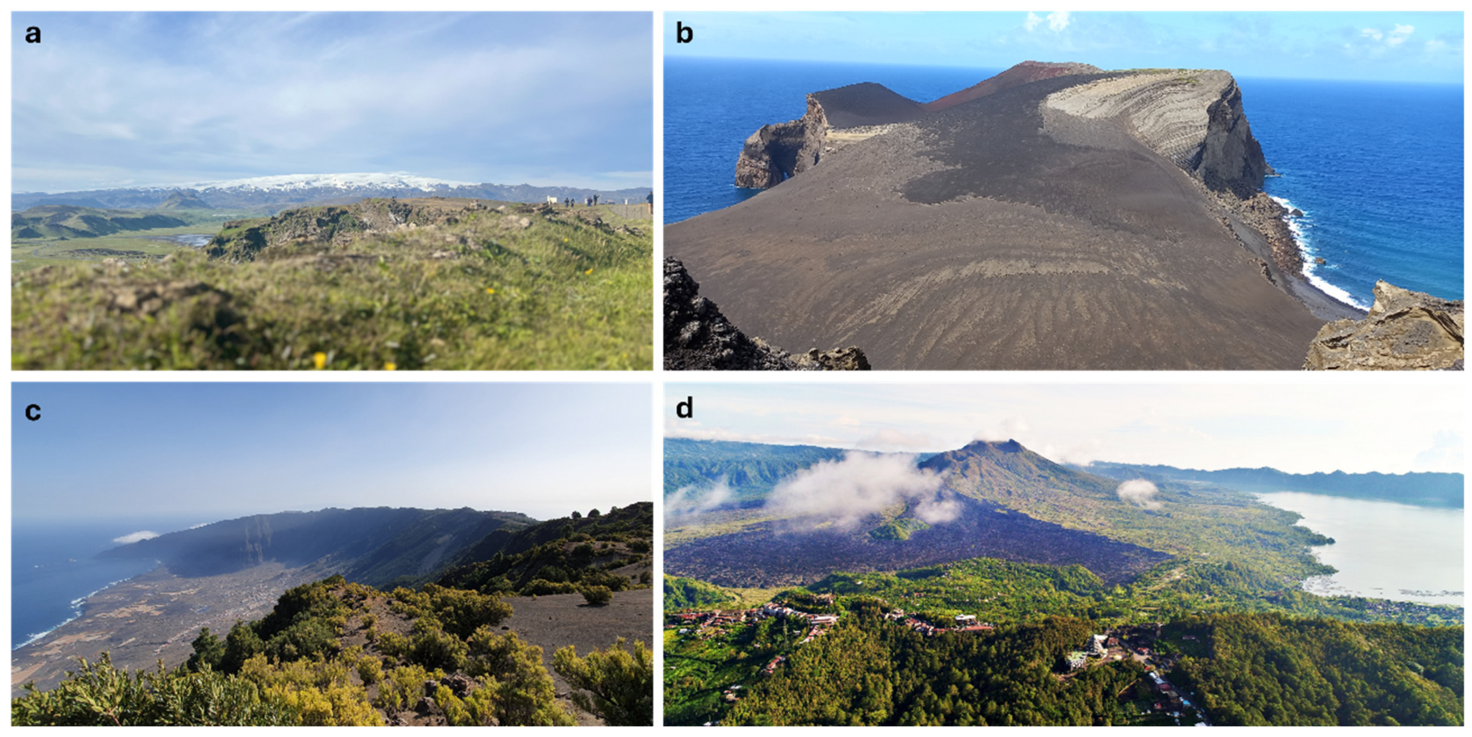
3.2. UGGp Dominated by Quaternary Volcanism and Recent Activity

Several island geoparks are characterized by active or recently active volcanic processes, where Quaternary volcanism defines both their landscape and geosite selection. In these territories, geoheritage is closely linked to eruptive structures, lava fields, calderas, geothermal features, and, in some cases, ongoing volcanic activity. A clear example is the Reykjanes UGGp in Iceland, which is notable for its exceptional geothermal activity and fissure occurring presently, associated with the Mid-Atlantic Ridge [21]. Similarly, the Katla UGGp includes outstanding examples such as the Eldgjá fissure eruption, one of the largest historical flood-basalt events (Figure 3a), and the hyaloclastite ridges of Kattarhryggir, formed by subglacial eruptions [22]. Also linked to the North Atlantic mid-ocean ridge system, the Azores UGGp (Portugal) includes all nine islands of the archipelago. It features 121 geosites, six of international relevance, such as the Capelinhos volcano (Figure 3b), an iconic example of mid-twentieth-century volcanism listed in the IUGS “First 100 Geological Heritage Sites” [23], but this geopark’s management is particularly complex due to its multi-island structure [10,24].
In the North Atlantic, the El Hierro UGGp became the first designated geopark in the Canary Islands (Spain). Its geological evolution was shaped by massive gravitational flank collapses, notably the “El Golfo” landslide (Figure 3c), recognized as Global Geosite VC010 [25]. The island gained renewed geological attention following the 2011 submarine eruption off its southern coast, which formed the underwater volcano Tagoro, still visible only in bathymetric records [26]. Among its 61 geosites, there are Holocene lava tubes preserving fossil bones of Gallotia simonyi and other extinct avifauna [27]. In Asia, the Toya-Usu UGGp (Japan) stands out as a natural laboratory for geohazard management, particularly after its twentieth-century eruptions [28], while the Unzen UGGp exemplifies community resurgence following the 1990–1995 eruption [29]. Centered around one of the world’s largest calderas, the Aso UGGp continues to be monitored by the Japan Meteorological Agency due to ongoing volcanic activity [30]. The Toba Caldera UGGp (Indonesia) features the largest caldera lake on Earth, formed by a super-eruption approximately 74,000 years ago that may have had global climatic and anthropological consequences [31,32]. More recently, around 1257 CE, Mount Rinjani erupted in what is now the Rinjani-Lombok UGGp, having major regional climatic impacts [33]. Other Indonesian geoparks, such as Batur (Figure 3d) and Ijen, also emphasize Quaternary volcanism that showcases calderas and volcanic lakes with extremely acidic waters [34,35].
In the Pacific Ocean, the Jeju Island UGGp (Republic of Korea) combines diverse volcanic morphologies that include Hawaiian, Strombolian, and phreatomagmatic styles with marine and aeolian erosional forms [36]. Its international significance is underscored by its triple UNESCO designation: Biosphere Reserve (2002), World Heritage Site (2007), and Global Geopark (2010) [37]. Similarly, the Leiqiong UNESCO Global Geopark (China), located on the Leizhou Peninsula in Northern Hainan Island, presents a remarkable assemblage of Quaternary basaltic volcanic landforms shaped by multiple eruptive phases [37]. The geopark features extensive lava plateaus, shield volcanoes, maars, and well-preserved volcanic cores, illustrating both effusive and explosive activity. This geodiversity is further enriched by the park’s coastal settings and tectonic background linked to the South China Sea marginal basin evolution, granting Leiqiong a high value in terms of volcanic, tectonic, and marine geoheritage.

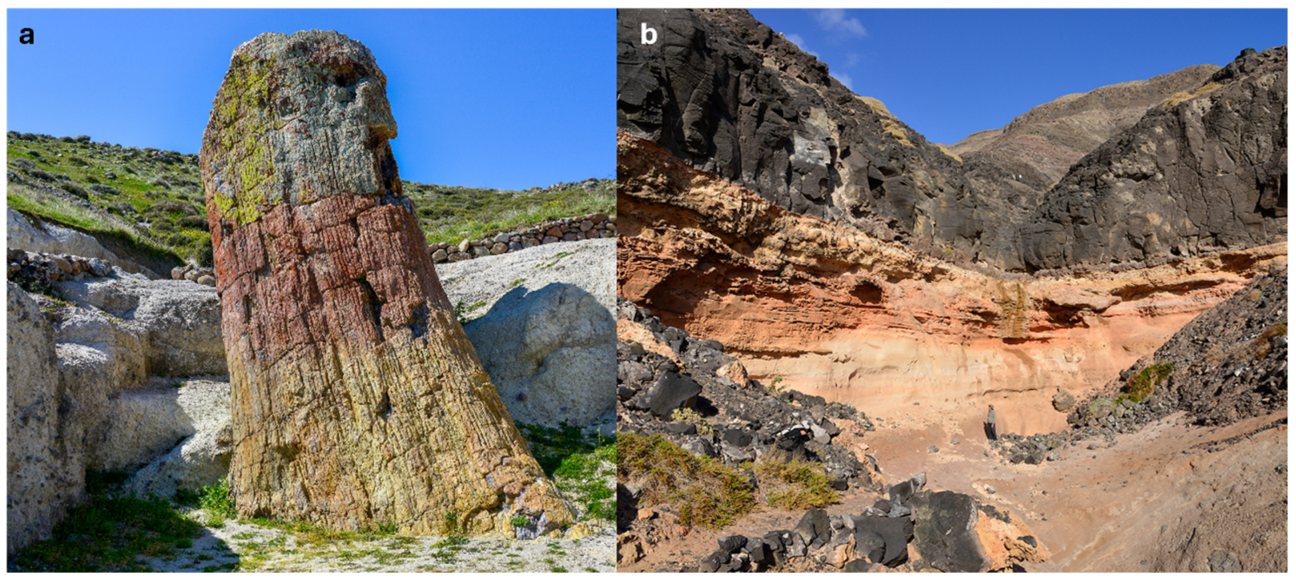
3.3. Geoparks Representing Broader Geological Narratives

In contrast to UGGp, which focused exclusively on recent volcanism, other island geoparks adopt a more comprehensive geological perspective, typically integrating longer geological time frames, fossil sites, tectonic and metamorphic features, or submerged volcanic structures. A key example is the Lanzarote and Chinijo Islands UGGp (Canary Islands, Spain), which was designated in 2015. It includes 82 geosites grouped into eight geological frameworks, several of which have international significance. More than 20 geosites are registered with the Global Geosite “Recent Volcanism of Timanfaya”, whereas 15 geosites explore aspects of submarine volcanic heritage [38,39]. Although limited to the Upper Miocene, the fossil sites record includes both marine and terrestrial localities (Figure 4b), having well-documented conservation concerns [40].
In Greece, the Lesvos UGGp is internationally renowned for its petrified forest, which contains an exceptional paleoflora record from the Miocene, complemented by volcanic, tectonic, and coastal geosites. Its early designation in 2004 was preceded in 1994 by the establishment of the Natural History Museum of the Lesvos Petrified Forest (Figure 4a). The museum became a model institution for geoscience and educational outreach [16,41].
In Japan, the Muroto UGGp documents neotectonic uplift related to the Nanjai Trough megathrust system [42], while the Izu Peninsula UGGp remains an active seismic zone shaped by arc-arc collision and frequent earthquake swarms [43]. In Indonesia, the Ciletuh-Palabuhanratu UGGp features Jurassic-Cretaceous oceanic crust together with fossil-bearing sediments alongside gravity-induced landforms such as the Ciletuh Amphitheatre [44].

3.4. Alternative Designations That Encompass the Formal Protected Status of Volcanic Island Geosites

Application of concepts and methodologies in geoconservation in the Azores archipelago also led to the Palaeopark on Santa Maria Island [45]. This approach stresses the scientific and touristic value of fossil sites, including two new geosites classified as the Ponta Castelo tempestite deposit and the Pedra-que-Pica coquina framed by volcanic deposits. These are classified as “Regional Natural Monuments” by the Regional Government of the Azores on account of their international relevance. The tempestite deposit at Ponta do Castelo is overlain by a coastal lava delta, which enables the inference of the site’s precise water depth immediately before the time of deposition [46]. The Pedra-que-Pica site is the most extensive multi-specific fossil coquina yet reported from the shelf of any of the ~20,000 known volcanic islands worldwide [47].

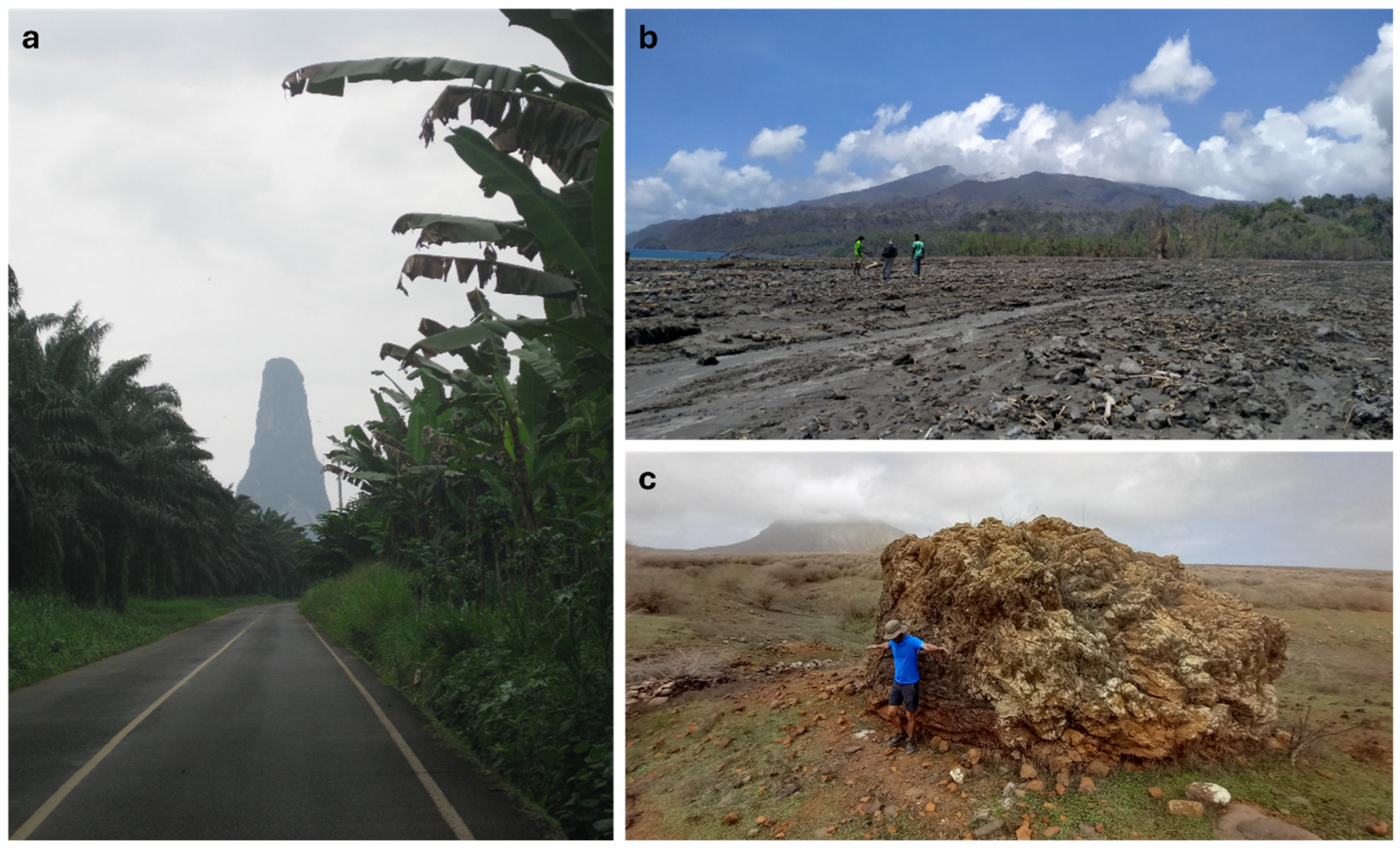
3.5. Volcanic Islands with Geoheritage Potential as Future UGGp

Only a limited number of volcanic islands are officially registered as UNESCO Global Geoparks, but several other regions around the world exhibit a geological heritage of international relevance. Many of these islands hold strong potential for future inclusion in the UNESCO program (Table 2; Figure 2). These territories display significant geodiversity—including volcanic, sedimentary, tectonic, and geomorphological features—often combined with ecological and cultural values. In many cases, they have already been the focus of scientific assessments, geosite inventories, or preliminary conservation initiatives, positioning them as credible candidates for geopark designation.
The selection of potential geopark territories presented here was guided by the following combination of factors: documented scientific literature, presence of inventoried geosites, institutional or community-driven interest in geoconservation, and evidence of emerging regional initiatives. Notably, some geologically outstanding regions such as Hawaii or other Pacific islands were not included—not due to a lack of geodiversity or heritage value, but because they either lack formal geopark proposals, have no publicly accessible geosite inventories, or are already managed under alternative conservation frameworks (e.g., national parks or heritage areas). This study prioritizes territories with available documentation and realistic pathways toward integration into the UNESCO Global Geoparks Network.
In Southeast Asia, the Krakatoa complex stands out as a globally significant geoheritage site due to the catastrophic 1883 eruption and its continued volcanic activity. Recent evaluations using the Indonesian Standard Scientific Value Assessment have highlighted its exceptional scientific, historical, and educational value [48]. Also in Indonesia, the Togean Islands exhibit outstanding geodiversity, including the Uma-Una solitary volcano, lava domes, karst features, and ophiolitic complexes. Although their geological significance is evident, further institutional support is needed to move the area toward formal geopark candidacy [49].
In the Pacific, Samoa presents a combination of volcanic and tectonic hazards, such as tsunamis, earthquakes, and landslides, that have increasingly been interpreted as opportunities for geoeducation and disaster risk awareness [50].
The stratovolcanoes of the Tongariro area, together with the Taupō geothermal fields in New Zealand’s central North Island, represent a geopatrimonial ensemble of exceptional scientific and educational value. These features are part of the Taupō Volcanic Zone, one of the most active rhyolitic volcanic systems on Earth, shaped by complex subduction-related processes. The region hosts iconic stratovolcanoes such as Mount Ngauruhoe and Mount Tongariro, alongside geothermal fields with geysers, hot springs, mud pools, and silica terraces. This dynamic landscape offers outstanding opportunities to study volcanism, geothermal activity, and landscape evolution, while also holding cultural significance for the Māori people. The combination of geological diversity, active processes, and cultural narratives makes this area a key candidate for geoconservation and geotourism within global geopatrimonial frameworks [51]. Its outstanding accessibility and educational potential provide a strong foundation for the promotion of geotourism and justify its candidacy for inclusion in the UNESCO Global Geopark network.
The islands of São Tomé and Príncipe, situated on the Cameroon Volcanic Line, also have undergone extensive geoheritage assessment. Key sites—such as phonolitic domes (Figure 5a), volcanic plugs, and fossil-rich marine platforms have been evaluated for their scientific and educational value, forming the basis for proposed geotourism and geoeducation strategies [52,53]. Relatedly, Annobon Island (Equatorial Guinea) has been the focus of a geoitinerary project that interprets the submerged geomorphology of its coral reef system as a living record of Darwinian evolution, linking biodiversity to volcanic island dynamics [53]. The Cabo Verde archipelago, particularly the islands of Fogo, Santo Antão, and Santiago, includes exceptional volcanic landscapes featuring well-preserved calderas, historic eruptions (e.g., Pico do Fogo), and sedimentary sequences that document long-term island evolution. Partial inventories of geosites have already been developed, and recent proposals emphasize both geotourism potential and community interest in geoheritage valorization [12]. Also on Santiago Island, extraordinary blocks sit in high relief as megatsunami deposits (Figure 5c).
The Fernando de Noronha archipelago, located in the South Atlantic Ocean, holds significant geoheritage value as a unique example of intraplate volcanism likely associated with a mantle hotspot. Its geodiversity includes phonolitic domes, basanitic lava flows, pyroclastic deposits, and well-preserved subvolcanic structures, which together allow the reconstruction of a polyphasic eruptive history spanning from 12 to 1.7 million years ago. This geological richness, combined with outstanding scenic, educational, and scientific relevance, underpins its designation as a Natural World Heritage Site and its current status as an aspiring UNESCO Global Geopark [54].
In the Caribbean region, lahar deposits from the 2021 eruption of La Soufriére volcano on Saint Vincent remain well exposed (Figure 5b) and constitute a potential geopark resource. Réunion Island (France) is recognized as a UNESCO World Heritage Site for its “pitons, cirques and ramparts” and features the Piton de la Fournaise, one of the most active volcanoes on Earth. Despite its global visibility and institutional infrastructure, the island is not yet part of the UGGp. Recent studies have advocated for its inclusion, emphasizing the combination of active volcanism, deep erosion structures, and public education initiatives linked to the Réunion National Park [55].
The Galapagos Islands, belonging to Ecuador, are globally renowned for their biodiversity and recognized as both a World Heritage Site and a Biosphere Reserve. Increasingly, they are appreciated for their underexploited geological value. Recent proposals suggest incorporating volcanic geoheritage and landscape evolution into geotourism and educational programs. The potential for developing structured geological itineraries—particularly on islands such as San Cristobal in order to complement existing biological narratives and support sustainable local economies is under consideration [56].
Elsewhere in the eastern Pacific Ocean region, Mexico’s Baja California peninsula includes multiple destinations with touristic value under the protection of national parks. The Loreto Bay National Park includes five islands in the southern part of the Gulf of California that achieved status as a Natural Protected Area in 1996. The islands of Coronados, Carmen, Danzante, Monserrat, and Catalina are well constrained within a setting of 206 square kilometers. Coronados is a volcanic island with a well-preserved edifice accessible by trail and a carbonate white-sand beach popular with tourists. It also features an uplifted lagoon containing a fossil coral reef. Isla del Carmen is the largest in the group with an area of 150 square kilometers dominated by Oligocene to Miocene andesite flows and a coastal exposure of an enormous tide-water delta dating from the Pliocene. Danzante is another andesite island popular with visitors for its coastal landscape that includes fragile rock pediments, otherwise known as mushroom rocks. More inaccessible is Isla Monserrat, which features a major unconformity between tilted andesite layers overlain by Pliocene limestone enriched by fossil rhodoliths. These four islands have come under considerable attention as potential candidates for the coexistence of a multi-island geopark under the protection of the existing national park [57].
In Europe, Madeira (Portugal) represents one of the most advanced volcanic island candidates in terms of heritage legislation and management. The region includes the Laurisilva World Heritage Site, a biosphere reserve, and a well-documented inventory of geosites. In addition, regional strategies for the conservation of geological heritage have already been adopted, although integration into a Global Geopark remains ongoing [58,59].
Sicily and the Aeolian Islands (Italy) are home to some of the most iconic active volcanoes—Mount Etna, Stromboli, and Vulcano—central to the historical development of volcanology. Despite their World Heritage designation, these territories have not yet been incorporated into the UGGp. Their rich geodiversity, combined with strong cultural integration, makes them highly eligible candidates [60,61]. Similarly, the island of Santorini in the Aegean Sea was shaped by the catastrophic Minoan eruption of 1613 BC [62] that destroyed much of the original landmass and created its present form, which lies within the tectonically active Hellenic Volcanic Arc. Characterized by subduction and crustal extension, this setting turns Santorini into a natural laboratory for studying Earth’s geological evolution. The formation of its emblematic caldera and the analysis of its volcanic deposits illustrate how volcanic processes can profoundly influence both natural landscapes and human history, revealing a rich and complex geological and cultural narrative [63].
The Faroe Islands (Denmark), although shaped by ancient and now inactive volcanic activity, offer well-preserved volcanic landscapes. Such remote and geologically distinctive systems, despite being understudied, could gain recognition for their geomorphological uniqueness and growing geotourism appeal—even in the absence of formal conservation frameworks [64]. Altogether, these island territories underscore the breadth of underrepresented volcanic island geoheritage across the globe (Figure 2). Their inclusion in the geopark framework would not only enhance regional geoconservation but also contribute to the diversification and geographical balance of the UNESCO Global Geoparks.
The Aleutian Arc represents an outstanding example of volcano-tectonic evolution along an active oceanic subduction margin. Accordingly [65], the arc’s dynamics reflect complex interactions between oblique subduction, volcanic front migration, and compositional variations in magmatism, controlled by changes in slab geometry and sediment input. These processes have generated remarkable geological diversity, reinforcing the Aleutians’ potential for geoscientific valorization and their possible designation as a geopark.

4. Discussion

Volcanic island geoparks represent a geographically constrained yet highly significant subset within the UNESCO Geoparks Network (UGGp). Their value lies not only in the spectacular nature and diversity of volcanic landscapes but also in the opportunity to study active geological processes in insular contexts, where endogenic dynamics manifestation with an intensity and visibility rarely found in continental environments [66,67].

4.1. The Geodiversity Perspective

From the geodiversity perspective, these territories stand out for the coexistence of multiple volcanic features—cones, calderas, lava tubes, pyroclastic fields—as well as landforms shaped by the interaction between volcanism and marine or climatic processes, such as marine terraces, reworked pyroclastic deposits, and erosional forms in tuff and ash. This geological richness supports not only scientific research but also biodiversity conservation, cultural heritage, and local economic activities such as geotourism [68,69]. Many of these islands represent key chapters in the history of volcanology worldwide.

4.2. The Conservation Perspective

The systematic assessment of geological features in volcanic island landscapes is Essential for promoting their conservation and sustainable use, especially in territories under strong anthropogenic pressure [12]. This is particularly relevant in small islands, where geological heritage tends to be highly concentrated, unique, and exposed to rapid transformation processes. The management of natural heritage—specifically geological heritage—in insular territories is both sensitive and complex. These islands function as coastal systems and are therefore especially vulnerable to global changes such as climate variability and sea level rise, as well as to anthropogenic disturbances, including land-use change, unregulated tourism, and urban expansion [70]. Despite their limited surface area, many of these islands host geosites of considerable scientific, educational, and aesthetic value—some already situated within formally protected areas.
However, a preliminary analysis of their geoconservation status reveals persistent threats, including illegal extraction of rocks and fossils, infrastructure development, mass tourism, and extractive industries. These pressures have, in some cases, led to the degradation or irreversible loss of geoheritage elements. Although legal protection mechanisms exist in certain contexts, they are often weakly enforced or disconnected from spatial planning frameworks.

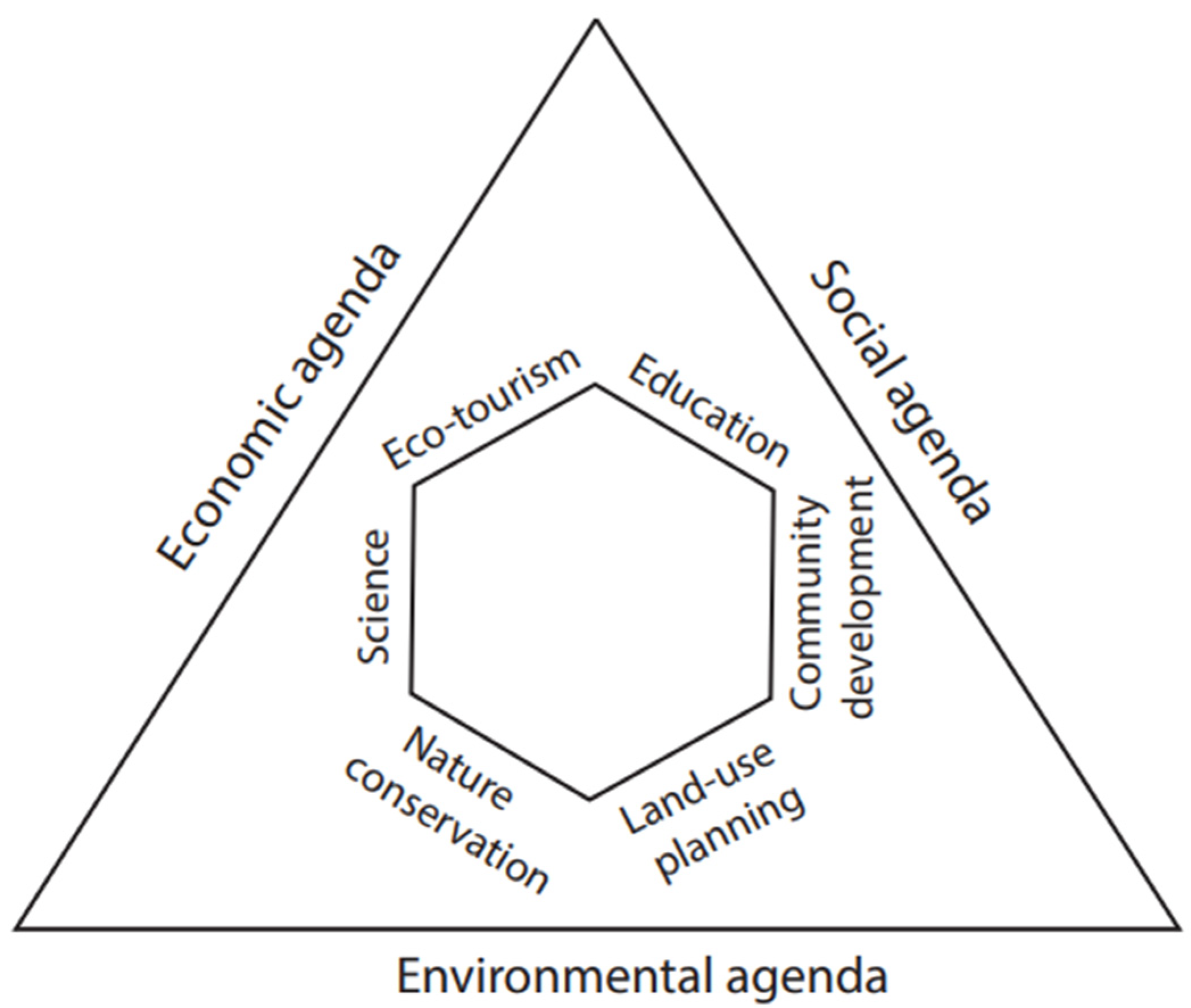
4.3. The Management Perspective

In response to these challenges, new management models are being proposed. One such approach involves the application of geosystems as a conceptual framework for geoconservation, particularly within geoparks. The Izu Peninsula Geopark in Japan offers a compelling case study. As described by [71], this model emphasizes the holistic evaluation of geodiversity, considers processes across broad spatiotemporal scales, and promotes the integration of abiotic, biotic, and cultural components. Such frameworks are especially relevant for island geoparks located near urban centers, where territorial conflicts and environmental pressures are most acute.
In terms of governance, insular geoparks face structural challenges: limited accessibility, dependency on external resources, seasonal fluctuations in tourism, and heightened exposure to geohazards. Nonetheless, some governance models—such as those implemented in the Azores UGGp, Lanzarote and Chinijo Islands UGGp, or Jeju UGGp—have successfully integrated local communities, scientists, and policymakers in territorial planning efforts aligned with conservation, education, and sustainable development objectives [72]. These integrated models, however, remain the exception rather than the norm.
Regarding representation within the UGGp, there exists a clear imbalance. Volcanic island UGGp are underrepresented in Africa, Oceania, and America, despite the evident geological potential of such regions (UNESCO as of 2023). This underrepresentation is not due to a lack of geodiversity and geoheritage, but rather to unequal access to institutional support, funding, and scientific expertise —factors that hinder many potential candidates from advancing toward formal designation.

5. Conclusions

In summary, safeguarding the geological heritage of volcanic island territories requires not only an accurate assessment and inventory but also adaptive management frameworks capable of integrating conservation goals with the complex socioecological realities of island systems. Volcanic island geoparks are not only natural laboratories of high scientific value; they are also strategic platforms for testing sustainable territorial models in ecologically and socially fragile environments under Climate Change scenarios. Their effective study and management demand integrative approaches that bridge geoscience with local governance. Expanding their presence within the UNESCO Global Geopark program will require overcoming structural barriers and fostering stronger international cooperation—particularly in the Global South.
This review is exploratory in nature and necessarily limited by the availability and accessibility of documentation on volcanic island geoparks, particularly those not yet formally integrated into the UNESCO Global Geoparks Network. The analysis relies primarily on published literature and institutional sources, which may overlook informal or emerging initiatives in less-documented regions. Furthermore, while the identification of potential territories is based on observable geodiversity and preliminary conservation actions, it does not account for local political, social, or economic constraints that may hinder actual geopark development.
Future research should aim to integrate field-based assessments, local stakeholder interviews, and geosite inventory validation to refine the evaluation of candidate territories. Comparative studies between designated and non-designated volcanic island geoparks could also help identify key success factors in geopark implementation. Lastly, examining how different governance models—national, regional, or international—affect geoconservation outcomes on islands would offer valuable insight for policy and planning.

Author Contributions

E.M.-G. initiated the project as a contribution to the Special Issue in the Journal of Marine Sciences and Engineering devoted to “Feature Review Papers in Geological Oceanography”. Original draft preparation, E.M.-G. Additional writing and review; C.R., J.V., I.G. and N.S. All authors have read and agreed to the published version of the manuscript.

Funding

This research received no external funding.

Acknowledgments

The authors thank Markes E. Johnson (Williams College) for the invitation to participate in the journal’s Special Issue and for his editorial assistance. We sincerely thank the anonymous reviewers for their thorough evaluation and constructive comments, which greatly improved the quality and clarity of this manuscript. Their insightful suggestions and critical observations have been invaluable in refining our arguments and strengthening the overall contribution of this work.

Conflicts of Interest

The authors declare no conflict of interest.

References

  1. Pescatore, E.; Bentivenga, M.; Giano, S.I. Geoheritage and geoconservation: Some remarks and considerations. Sustainability 2023, 15, 5823. [Google Scholar] [CrossRef]
  2. Website for the International Geoscience and Geoparks Programme. 2025. Available online: www.unesco.org/en/iggp/geoparks/about (accessed on 21 May 2025).
  3. Németh, K.; Casadevall, T.; Moufti, M.R.; Martí, J. Volcanic geoheritage. Geoheritage 2017, 9, 251–254. [Google Scholar] [CrossRef]
  4. Casadevall, T.; Tormey, D.; Roberts, J. World Heritage Volcanoes: Classification, Gap Analysis, and Recommendations for Future Listings; IUCN: Gland, Switzerland, 2019. [Google Scholar]
  5. Pimentel, A.; Ramalho, R.S.; Becerril, L.; Larrea, P.; Brown, R.J. Editorial: Ocean island volcanoes: Genesis, Evolution and Impact. Front. Earth Sci. 2020, 8, 82. [Google Scholar] [CrossRef]
  6. Menard, H.; Ladd, H. Oceanic islands, seamounts, guyots and atolls. In The Sea, 3rd ed.; Hill, M.N., Ed.; Wiley Interscience: New York, NY, USA, 1963; pp. 365–385. [Google Scholar]
  7. Ramalho, R.S.; Quartau, R.; Trenhaile, A.S.; Mitchell, N.C.; Woodroffe, C.D.; Ávila, S.P. Coastal evolution on volcanic oceanic islands: A complex interplay between volcanism, erosion, sedimentation, sea-level change and biogenic production. Earth Sci. Rev. 2013, 127, 140–170. [Google Scholar] [CrossRef]
  8. Perfit, M.R.; Davidson, J.P.; Sigurdsson, H. Plate tectonics and volcanism. In Encyclopedia of Volcanoes; Academic Press: Cambridge, MA, USA, 2000; pp. 89–113. [Google Scholar]
  9. Dóniz-Páez, J.; Beltrán-Yanes, E.; Becerra-Ramírez, R.; Pérez, N.; Hernández, P.; Hernández, W. Diversity of volcanic geoheritage in the Canary Islands, Spain. Geosciences 2020, 10, 390. [Google Scholar] [CrossRef]
  10. Lima, E.A.; Machado, M.; Guerreiro, M.; Nunes, J.C.; Costa, M.P. Geological heritage management in small islands: The example of the Azores UNESCO Global Geopark (Portugal). Geoheritage 2018, 10, 659–671. [Google Scholar] [CrossRef]
  11. Pérez-Hernández, E.; Ferrer, N.; Hernández-Calvento, L. Lost and preserved coastal landforms after urban growth. The case of Las Palmas de Gran Canaria city (Canary Islands, Spain). J. Coast. Conserv. 2020, 24, 26. [Google Scholar] [CrossRef]
  12. Alfama, V.; Henriques, M.H.; Barros, A. The challenging nature of volcanic heritage: The Fogo Island (Cabo Verde, W Africa). Geoheritage 2024, 16, 34. [Google Scholar] [CrossRef]
  13. Ferrer, N.; Vegas, J.; Galindo, I.; Lozano, G.A. Geoheritage valuation to prevent environmental degradation of a new volcanic landscape in the Canary Islands. Land Degrad. Dev. 2023, 34, 2494–2507. [Google Scholar] [CrossRef]
  14. Ramos, W.H.; Pérez, N.; Dóniz-Páez, J.; García-Hernández, R. Evaluation of sites of geotouristic interest on active volcanic island La Palma, Spain for potential volcanic tourism. Geoheritage 2024, 16, 102. [Google Scholar] [CrossRef]
  15. García-Casco, A.; García-Delgado, D. Islands as natural laboratories for geological heritage. Episodes 2023, 46, 289–299. [Google Scholar]
  16. Zouros, N. Lesvos petrified forest Geopark, Greece: Geoconservation, geotourism, and local development. Geoparks 2010, 27, 19–28. [Google Scholar]
  17. Henriques, M.H.; Pena dos Reis, R.; Brilha, J.; Mota, T.S. Geoconservation as an emerging geoscience. Geoheritage 2011, 3, 117–128. [Google Scholar] [CrossRef]
  18. Website for the United Nations Educational Scientific and Cultural Organization Program Related to Its Global Geopark Program in China. Available online: http://www.globalgeopark.org.cn/ (accessed on 15 May 2025).
  19. Website for the UNESCO Program Related to Geoparks in the Asian Pacific Region. Available online: https://asiapacificgeoparks.org/ (accessed on 15 May 2025).
  20. Vegas, J.; Galindo, I.; Romero, C.; Sánchez, N.; Díaz, G.A.; Martín-González, E.; Mateo, E. Geoconservation and geotourism in the Lanzarote and Chinijo Islands UNESCO Global Geopark. In Lanzarote and Chinijo Islands Geopark: From Earth to Space, Geoheritage, Geoparks and Geotourism; Mateo, E., Martínez-Frías, J., Vegas, J., Eds.; Springer: Cham, Switzerland, 2019. [Google Scholar] [CrossRef]
  21. Jousset, P.; Mortensen, A.K.; Fridleifsson, G.O.; Ágústsoon, K.; Gudmundsson, M.T. Reykjanes, Iceland: Structure and dynamics of mid-oceanic ridge geo/hydrothermal systems. J. Volcanol. Geotherm. Res. 2020, 391, 106692. [Google Scholar] [CrossRef]
  22. Jóhannesson, J.M.; Sigmundsdóttir, B.; Sigursveinsson, S. Volcanic features within Katla UNESCO Global Geopark. Geoconserv. Res. 2023, 6, 53–69. [Google Scholar]
  23. Lima, E.A.; Meneses, S. Azores UNESCO Global Geopark: Where volcanoes tell us their stories. Geoconserv. Res. 2023, 6, 114–127. [Google Scholar]
  24. Nunes, J.C. The Azores Archipelago: Islands of geodiversity. In Volcanic Tourist Destinations; Erfurt-Cooper, P., Ed.; Springer: New York, NY, USA, 2014; pp. 57–67. [Google Scholar]
  25. Casillas, R.; Candelario, Y.P.; Fernández, C.F. El Hierro UNESCO Global Geopark: Geological heritage, geoconservation and geotourism. Geoconservation Res. 2023, 6, 128–138. [Google Scholar]
  26. Vegas, J.; Galindo, I.; Vázquez, J.T.; León, R.; Sánchez, N.; Martín-González, E.; Romero, C. Tagoro, the Youngest Submarine Volcano in the Spanish Geoheritage Inventory: Scientific Value, Geoconservation and Opportunities for Geotourism. In El Hierro Island; Active Volcanoes of the World; González, P.J., Ed.; Springer: Cham, Switzerland, 2023; pp. 257–272. [Google Scholar] [CrossRef]
  27. Martín-González, E.; Coello, J.J.; Castillo, C.; González-Rodríguez, A.; Galindo, I.; Vegas, J. Revisión del patrimonio paleontológico del Geoparque Mundial de la Unesco de El Hierro. Geogaceta 2019, 65, 11–17. [Google Scholar]
  28. Jones, T.E. Evolving approaches to volcanic tourism crisis management: An investigation of long-term recovery models at Toya-Usu Geopark. J. Hosp. Tour. Manag. 2016, 28, 31–40. [Google Scholar] [CrossRef]
  29. Gomez, C.; Wassmer, P. Evolution of the Unzen Volcano and the Shimabara Peninsula (Japan) during the last 60 years: The role of the 1990–1995 eruption in modifying the landscape. Géomorphologie 2015, 21, 205–216. [Google Scholar] [CrossRef]
  30. Sato, E.; Fukui, K.; Shimbori, T. Aso volcano eruption on October 8, 2016, observed by weather radars. Earth Planets Space 2018, 70, 105. [Google Scholar] [CrossRef]
  31. Petraglia, M.D.; Korisettar, R.; Pal, J.N. The Toba volcanic super-eruption of 74,000 years ago: Climate change, environments, and evolving humans. Quat. Int. 2012, 258, 1–4. [Google Scholar] [CrossRef]
  32. Muzambiq, S.; Sibarani, R.; Nasution, Z.P.; Gustanto, G. Geoheritage and cultural heritage overview of the Toba caldera geosite, North Sumatra, Indonesia. Smart Tour. 2024, 5, 2517. [Google Scholar] [CrossRef]
  33. Rachmat, H. The Geomorphology of the Rinjani Volcanic Complex, Lombok Island, Indonesia: A Result of a Major Historic Eruption; IAG: París, Francia, 2013. [Google Scholar]
  34. Reubi, O.; Nicholls, I.A. Structure and dynamics of a silisic magmatic system associated with caldera-forming eruptions at Batur volcanic field, Indonesia. J. Petrol. 2005, 46, 1367–1391. [Google Scholar] [CrossRef]
  35. Delmelle, P.; Bernard, A. Dowstream composition changes of acidic volcanic waters discharged into the Banyupahit stream, Ijen Caldera, Indonesia. J. Volcanol. Geotherm. Res. 2000, 97, 55–75. [Google Scholar] [CrossRef]
  36. Jeon, Y.; Ki, J.; Southcott, D. Koren geoheritage: The volcanic landforms of the Jeju Island UNESCO Global Geopark. Episodes 2024, 7, 295–310. [Google Scholar] [CrossRef] [PubMed]
  37. Wei, F.; Wei, W.; Yu, H. The Cenozoic volcanic fields in northern Hainan Island and Leizhou Peninsula, South China: Eruption history, magma source and dynamic background. Geol. Soc. Lond. Spec. 2020, 510, 179–196. [Google Scholar] [CrossRef]
  38. Galindo, I.; Vegas, J.; Romero, C.; Llorente, M.; Martín-González, E.; Rubio, J.C.; Díaz, G.A.; Mangas, J.; Mateo, E.; Sánchez, N. Geoheritage inventory of the Lanzarote and Chinijo Islands UNESCO Global Geopark. In Lanzarote and Chinijo Islands Geopark: From Earth to Space, Geoheritage, Geoparks and Geotourism; Mateo, E., Martínez-Frías, J., Vegas, J., Eds.; Springer: Cham, Switzerland, 2019. [Google Scholar] [CrossRef]
  39. Galindo, I.; Romero, C.; Llorente, M.; Rubio, J.C.; Díaz, G.A.; Sánchez, N.; Martín-González, E.; Mangas, J.; Vegas, J. Geoheritage in the shallow submarine slopes of fan oceanic volcanic edifice: A new option for diving geotourism. In Lanzarote and Chinijo Islands Geopark: From Earth to Space, Geoheritage, Geoparks and Geotourism; Mateo, E., Martínez-Frías, J., Vegas, J., Eds.; Springer: Cham, Switzerland, 2019. [Google Scholar] [CrossRef]
  40. Martín-González, E.; Galindo, I.; Romero, C.; Sánchez, N.; Vegas, J. Evaluation of geoconservation in geosites of palaeontological interest from Lanzarote and Chinijo Islands UNESCO Global Geopark. In Lanzarote and Chinijo Islands Geopark: From Earth to Space, Geoheritage, Geoparks and Geotourism; Mateo, E., Martínez-Frías, J., Vegas, J., Eds.; Springer: Cham, Switzerland, 2019. [Google Scholar] [CrossRef]
  41. Wang, J.; Zouros, N. Educational activities in Fangshan UNESCO Global Geopark and Lesvos Island UNESCO Global Geopark. Geoheritage 2021, 13, 51. [Google Scholar] [CrossRef]
  42. Nakamura, Y.; Yuhora, K. Muroto Geopark: Understanding the moving Earth. In Natural Heritage of Japan: Geoheritage, Geoparks and Geotourism; Chakraborty, A., Mokudai, K., Cooper, M., Watanabe, M., Chakraborty, S., Eds.; Springer: Cham, Switzerland, 2018. [Google Scholar] [CrossRef]
  43. Nanjo, K.Z.; Yukutake, Y.; Kumazawa, T. Changes in Seismicity in a Volcanically Active Region of the Izu Peninsula, Japan. 2024. Available online: https://ssrn.com/abstract=5097110 (accessed on 30 April 2025).
  44. Irzon, R.; Samodra, H.; Permanadewi, S. Prospecting CCS project in Indonesia: A case study in Meratus Mountains, South Borneo. J. Geol. Miner. Resour. 2024, 25, 31–40. [Google Scholar] [CrossRef]
  45. Ávila, S.P.; Cachão, M.; Ramalho, R.S.; Botelho, A.Z.; Madeira, P.; Rebelo, A.C.; Cordeiro, R.; Melo, C.; Hipólito, A.; Ventura, M.A.; et al. The palaeontological heritage of Santa Maria Island (Azores: NE Atlantic): A re-evaluation of geosites in geopark Azores and their use in geotourism. Geoheritage 2016, 8, 155–171. [Google Scholar] [CrossRef]
  46. Meireles, R.P.; Quartau, R.; Ramalho, R.S.; Rebelo, A.C.; Madeira, J.; Zanon, V.; Ávila, S.P. Depositional processes on oceanic island shelves—Evidence from storm-generated Neogene deposits from the mid-North Atlantic. Sedimentology 2013, 60, 1769–1785. [Google Scholar] [CrossRef]
  47. Rebelo, A.C.; Rasser, M.W.; Kroh, A.; Johnson, M.E.; Ramalho, R.S.; Melo, C.; Uchman, A.; Berning, B.; Silva, L.; Zanon, V.; et al. Rocking around a volcanic island shelf: Pliocene rhodolith beds from Malbusca, Santa Maria Island (Azores, NE Atlantic). Facies 2016, 62, 22. [Google Scholar] [CrossRef]
  48. Harbowo, D.G. An assessment of the scientific value of Krakatoa, Indonesia from a geoheritage perspective. J. Appl. Geosci. Eng. 2023, 2, 11–25. [Google Scholar] [CrossRef]
  49. Sendjaja, P.; Suparka, E.; Botjing, M.U. Geodiversity of the Togean Islands National Park, Central Sulawesi Province for Geopark Assessment. IOP Conf. Ser. Earth Environ. Sci. 2020, 589, 012023. [Google Scholar] [CrossRef]
  50. Fepuleai, A.; Nemeth, K. Volcanic geoheritage of landslides and rockfalls on a tropical ocean island (Western Samoa, SW Pacific). Geoheritage 2018, 11, 577–596. [Google Scholar] [CrossRef]
  51. Migon, P.; Pijet-Migon, E. Geoconservation and tourism at geothermal sites—Lessons learnt from the Taupo volcanic zone, New Zealand. Proc. Geol. Assoc. 2016, 127, 413–421. [Google Scholar] [CrossRef]
  52. Henriques, M.H.; Neto, K. Geoheritage at the Equator: Selected geosites of Sao Tomé Island (Cameron Line, Central Africa). Sustainability 2015, 7, 648–667. [Google Scholar] [CrossRef]
  53. Henriques, M.H.; Neto, K.A. Geo-itinerary to foster sustainable tourism in West African Islands: Storytelling the evolution of the ancient Cameroon Volcanic Line coral reefs. Sustainability 2023, 15, 16863. [Google Scholar] [CrossRef]
  54. Moreira, J.C.; Vale, T.F.; Burns, R.C. Fernando de Noronha Archipelago (Brazil): A Coastal Geopark Proposal to Foster the Local Economy, Tourism and Sustainability. Water 2021, 13, 1586. [Google Scholar] [CrossRef]
  55. Michon, L.; Di Muro, A.; Villeneuve, N.; Saomt-Marc, C.; Fadda, P.; Manta, F. Explosive activity of the summit of Piton de la Fournaise volcano (La Réunion Island): A historical and geological review. J. Volcanol. Geotherm. Res. 2013, 264, 117–133. [Google Scholar] [CrossRef]
  56. Carrión-Mero, P.; Sánchez-Zambrano, E.; Mata-Perelló, J.; Jaya-Montalvo, M.; Herrera-Franco, G.; Berrezueta Espinel, R.; Baque, M.; Morante-Carballo, F. Geosites assessment in a volcanic hotsot environment and its impart on geoturism, Santa Cruz-Galapagos Islands, Ecuador. Int. J. Geoherit. Parks 2024, 12, 147–167. [Google Scholar] [CrossRef]
  57. Johnson, M.E.; Ledesma-Vázquez, J. Gulf of California Coastal Ecology: Insights from the Present and Patterns from the Past; Sunbelt Publications: San Diego, CA, USA, 2016; 134p. [Google Scholar]
  58. da Silveira, A.B.; Prada, S.; Ramalho, R.; Madeira, J.; Fonseca, P.; Canha, E.; Brilha, E. Inventariaço do património geológico da Ilha da Madeira. Secretaria Regional do Ambiente e Recursos Naturais—Relatório Final 2012, 414p. Available online: https://geodiversidade.madeira.gov.pt (accessed on 23 June 2025).
  59. Sotiriou, P.; Nunes, P. The geoheritage of Madeira: Implications for Natural Heritage and geotourism. Geoheritage 2024, 16, 74. [Google Scholar] [CrossRef]
  60. Francaviglia, V. Characterization of Mediterranean obsidian sources by classical petrochemical methods. Preist. Alp. 1984, 20, 311–332. [Google Scholar]
  61. Keller, J. Lipari’s fiery past: Dating the medieval pumice eruption of Monte Pelato. In Proceedings of the International Conference ‘The Fire Between Air and Water’, UNESCO-Regione, Siciliana, Lipari, Italy, 29 September–2 October 2002. [Google Scholar]
  62. Friedrich, W.L.; Heinemeier, J. The Minoan eruption of Santorini radiocarbon dated to 1613 ± 13 BC—Geological and stratigraphic considerations. In Time’s Up! Dating the Minoan Eruption of Santorini; Warburton, D.A., Ed.; Monographs of the Danish Institute: Athens, Greece, 2009; Volume 10, pp. 57–63. [Google Scholar]
  63. Preine, J.; Karstens, J.; Hübscher, C.; Druitt, T.; Kutterolf, S.; Nomikou, P.; Manga, M.; Gertisser, R.; Pank, K.; Beethe, S.; et al. Hazardous explosive eruptions of a recharging multi-cyclic island arc caldera. Nat. Geosci. 2024, 17, 323–331. [Google Scholar] [CrossRef]
  64. Raška, P.; Pokomý, R.; Krmíček, L.; Kubouškova, S.; Mortensen, L. Basaltic dyke with specific volcanogenic structures and its geomorphic evolution: Unique geoheritage of the Faroe Islands (North Atlantic Ocean). Geoheritage 2019, 11, 417–426. [Google Scholar] [CrossRef]
  65. Jicha, B.R.; Scholl, D.W.; Singer, B.; Yogodzinski, G.; Kay, S.M. Revised age of Aleutian Island Arc formation implies high rate of magma production. Geology 2006, 34, 661–664. [Google Scholar] [CrossRef]
  66. Wood, C.A. Volcanoes of the World. In Encyclopedia of Volcanoes; Sigurdsson, H., Ed.; Academic Press: Cambridge, MA, USA, 2009; pp. 3–17. [Google Scholar]
  67. Németh, K. Volcanic Geoheritage in the Light of Volcano Geology. In El Hierro Island Global Geopark; Dóniz-Paez, J., Pérez, N.M., Eds.; Springer: Berlin/Heidelberg, Germany, 2023; pp. 1–32. [Google Scholar] [CrossRef]
  68. Gray, M. Geodiversity: Valuing and Conserving Abiotic Nature, 2nd ed.; Wiley-Blackwell: Hoboken, NJ, USA, 2013. [Google Scholar]
  69. Brilha, J. Inventory and quantitative assessment of geosites and geodiversity sites: A review. Geoheritage 2016, 8, 119–134. [Google Scholar] [CrossRef]
  70. Saffache, P.; Angelelli, P. Environmental challenges in the small islands of the Caribbean: The example of Martinique. Caribb. Geogr. 2010, 15, 83–95. [Google Scholar]
  71. Chakraborty, A.; Mogi, K.; Takemura, K. Geosystem and geopark: A holistic approach to natural hazard studies in the Izu Peninsula Geopark, Japan. J. Geol. Soc. India 2015, 86, 525–533. [Google Scholar]
  72. Reynard, E.; Brilha, J. (Eds.) Geoheritage: Assessment, Protection, and Management; Elsevier: Amsterdam, The Netherland, 2018. [Google Scholar] [CrossRef]
Figure 1. Interrelationship of tripart agendas that characterize successful UNESCO Global Geoparks (UGGp).
Jmse 13 01420 g001
Figure 2. Map showing the global distribution of UNESCO Global Geoparks islands (patches in green) as well as the location of potential new geopark islands (patches in orange), some of which occur within territories already conserved by other means, such as national parks. Reference system: EPSG:32600-WGS 84. Map projection: UTM grid system (northern hemisphere).
Jmse 13 01420 g002
Figure 3. UNESCO Global Geoparks featuring Quaternary or recent volcanic activity; (a) Southern view of Katla Volcano, Katla UGGp in Iceland (courtesy of Jóhannes M. Jóhanneson, project manager); (b) Capelinhos Volcano, Azores UGGp (Esther Martín photo); (c) El Golfo gravitational landside, El Hierro UGGp (Carmen Romero photo); (d) Mount Batur Caldera, Batur UGGp (courtesy of Oka Agastya, geopark geoscientist).
Jmse 13 01420 g003
Figure 4. Fossil geosites associated with geoparks in Greece and the Canary Islands of Spain. (a) The tallest standing petrified tree from the Lesvos Petrified Forest in the Lesvos UNESCO Global Geopark (courtesy of the Natural History Museum of the Lesvos Petrified Forest) in Greece; (b) Pliocene fossil site of Valle Chico in the Lanzarote and Chinijo Islands UNESCO Global Geopark in the Canary Islands (Esther Martín photo).
Jmse 13 01420 g004
Figure 5. Potential island geoparks with adequate background information and scenery occur in the Atlantic Ocean. (a) Cão Grande, the most emblematic geosite of São Tomé Island (image courtesy of Maria Helena Henriques); (b) Lahar deposits from the 2021 eruption of La Soufrière volcano, Saint Vincent (Nieves Sánchez photo); (c) Megatsunami-deposited blocks on Santiago Island, Cabo Verde (Esther Martín photo).
Jmse 13 01420 g005
Table 1. List of officially recognized UNESCO Global Geoparks related to volcanic islands.
Geopark/CountryYearArea (km2)Base AgeKey Geological Features
Toya-Usu, Japan20081181QuaternaryPyroclastic flow forming caldera depression
Unzen Area, Japan2009459PlioceneLava domes and pyroclastic deposits
Aso Area, Japan20132QuaternaryLava flows and tephra layers
Oki Islands, Japan2013674Permian-TriassicVolcanic rocks and mantle xenoliths; aquatic fossils
Mt. Apoi, Japan2015364MiocenePeridotites from earth’s mantle
Itoigawa, Japan2015750CambrianEast-West tectonic line of separation
San’lin Kaigan, Japan2015246MioceneGranite outcrops and other volcanics
Muroto, Japan2015248PaleogeneAccretionary complex at plate boundary
Izu Peninsula, Japan20162027MiocenePillow lava; pumice; scoria cone, hot spring
Hakusan Tedorigawa, Japan2023755PermianContinental collision; dinosaur tracks
Batur, Indonesia2012370QuaternaryLava flows, fumaroles, lake calderas
Ciletuh-Palabuhanratu, Indonesia20151260OligoceneTectonic processes, hot springs; geysers
Rinjani-Lombock, Indonesia20182800OligoceneIntrusive igneous rocks and volcanoes
Toba Caldera, Indonesia20201165QuaternaryLandscape from a plinnian eruption
Ijen Lake, Indonesia20234723QuaternaryThe world’s most acidic volcanic lake with sulfuric gases that ignite blue flames
Kebjumen, Indonesia20251139Early CretaceousTectonic records dating back 119 million years; caves, and underground rivers
Meratus, Indonesia20253645Early JurassicIndonesia’s oldest and most complete ophiolite sequence
Leiquiong, Hainan, China20153050QuaternaryBasaltic and phreatomagmatic craters
Katla, Iceland20159542QuaternaryFissures and hyaloclastite ridges; ice-capped volcanoes and tuff deposits
Jeju Island, Republic of Korea20101847QuaternaryBasaltic—trachytic lavas; tuff rings and cones
Reykjanes, Iceland2014825QuaternaryFissure swarms and geothermal fields
Lesvos Island, Greece20151636MioceneVolcanic hot springs and fossil sites
El Hierro Island, Spain2014595QuaternaryGravitational landslides; pyroclastic cones
Lanzarote and Chinijo Islands, Spain2015250MiocenePrehistoric and historic volcanism; fossils; aeolian deposits, submarine processes
Azores islands, Portugal2013 MioceneCaldera lakes, fumaroles, and hot springs; steam-cooked meals
Table 2. Volcanic island territories with potential for inclusion in UNESCO Global Geoparks.
IslandBase AgeKey Geological Features
Krakatoa (Indonesia)QuaternaryCatastrophic historical volcanism
Togean Islands (Indonesia)Neogene-QuaternaryVolcanoes, lava domes, karst, and ophiolites
Samoa (Samoa)QuaternaryActive geodynamic processes (tsunamis, earthquakes, volcanoes)
Gwanmae Island (Republic of Korea)QuaternaryVolcanic landscape
North Island (New Zealand)QuaternaryStratovolcanoes of Tongariro Area, Taupo geothermal fields
Fogo, Santo Antão and Santiago (Cabo Verde)Neogene-QuaternaryActive volcanism, tsunami deposits
São Tomé and Príncipe (São Tomé and Príncipe)Neogene-QuaternaryAlkaline volcanism
Annobón (Equatorial Guinea)NeogeneSubmerged geomorphology, coral platforms
Madeira (Portugal)NeogeneVolcanism, coastal geomorphology, fossils deposit
Etna (Sicily) and Aeolian Islands (Italy)QuaternaryActive and historic volcanoes, cultural heritage
Santorini Island (Greece)Pliocene-QuaternaryActive caldera subsidence
Faroe Islands (Denmark)EoceneAncient volcanic landscapes, unique geoforms
Aleutian Islands Arc (United State)Neogene-QuaternaryMore than fifty active volcanoes
Fernando Noronha (Brazil)Neogene-QuaternaryNoronha hotspot
Réunion Island (France)QuaternaryPitons, cirques and ramparts
Saint Vicent (Saint Vincent and the Grenadines)PlioceneLa Soufrière volcano, lahars
Galápagos (Ecuador)QuaternaryInsular volcanism, calderas, active geosites
Coronados Island, Baja California (Mexico)QuaternaryVolcanic cone and lagoon with fossil corals
Carmen Island, Baja California (Mexico)NeogeneTide-water delta in a volcanic landscape
Danzante Island, Baja California (Mexico)NeogeneAndesite flows and coastal rock pediments
Monserrat Island, Baja California (Mexico)NeogeneTilted andesite covered by Pliocene limestone
Disclaimer/Publisher’s Note: The statements, opinions and data contained in all publications are solely those of the individual author(s) and contributor(s) and not of MDPI and/or the editor(s). MDPI and/or the editor(s) disclaim responsibility for any injury to people or property resulting from any ideas, methods, instructions or products referred to in the content.

