Abstract
Many organic-rich marine mudstones, which are key hydrocarbon sources, were deposited on continent margins in mid-water oxygen-minimum zones (OMZs) that expanded and intensified during oceanic anoxic events (OAEs). Other marine hydrocarbon sources include platform and forearc black shales that record trans-continental, long-erm anoxic/dysoxic environments with no modern analog. Their explanation as recording deep-water, Black Sea-type basins or low-oxygen upwelling is not satisfactory for occurrences on shelves that lack significant epeirogenic activity, while modern studies show that upwellings do not cross the shelf break. The alternative is the Bakken model, which concludes that regionally extensive shelves and forearc organic-rich mudstones are shallow-water facies. These Bakken facies reflect hyper-warming conditions with high sea-levels, high water temperatures with increased insolation and low oxygen solubility, turbid water due to algal blooms and mud eroded from orogenic highlands, and possible LIP activity. Early Paleozoic black shales indicate that increased nutrients presumed to accompany the Devonian appearance of forests with deep roots that enhanced weathering simply cannot explain older Cambrian–Ordovician shelf anoxia/dysoxia. Shallow-marine deposition by the Bakken model is mandated by black shales deposited on subaerial unconformities that show high-energy facies (wave cross beds, HCS) and common bioturbation. The Bakken model explains shallow anoxia/dysoxia with high Paleozoic sea levels and tropical distribution of large continents. It is based on the Upper Devonian–lower Mississippian Bakken Formation (western U.S. and adjacent Canada). Rising temperatures, diminished oxygen solubility, and eustatic rise with deglaciation accompany modern climate change and mean that near-future platform seas will feature the reappearance of low-oxygen Bakken facies and environments.
1. Introduction
Oil and natural gas exploration and production focus on organic-rich marine mudstones. These facies, with 5–65% total organic carbon (TOC) [1], are the main economic source rock for petroleum and natural gas, which may be fracked (hydraulically fractured) or have migrated into more porous units. These fine-grained units can also form relatively impermeable top seals for hydrocarbon accumulation. No single explanation exists for organic-rich mudstones, and their origin, other than being the product of low-oxygen, dysoxic/anoxic (d/a) deposition, is contentious. Organic-rich marine mudstones occur in three types of settings. These include the giant fields on continental margins in break-up or collisional settings. Break-up settings include the northern Gulf of Mexico (Figure 1, upper Jurassic and middle Cretaceous [2]) and the North Sea (Middle Jurassic [3]), and collisional (and barred) basins include the Permian Basin of New Mexico and West Texas [4] and the Jurassic of the Arabian Gulf [5].
The third type of giant (or potentially giant) oil field occurs within continents and comprises widespread organic-rich mudstones. Some examples have undergone little thermal maturation, such as the terminal Devonian–lower Mississippian heavy oils of the Bakken Formation in the Williston Basin, western US and adjacent Canada (Figure 1, intervals 17, 18) [6]. An older organic-rich mudstone is the Upper Ordovician Utica Shale (and related units) that covers much of the eastern United States west of the Appalachian Mountains [7]. The uppermost Jurassic of the extensive West Siberian Basin is the source of much exported Russian oil (Figure 1, horizon 25) [8,9]. Note that in this report, Lower/Early, Middle/Middle, Upper/Late Cambrian refer to the precisely defined proposed subsystems/subperiods that replaced the undefined subsystem-level terms “lower”/“early”, “middle”/”middle”, and “upper”/“late” of many reports [10].
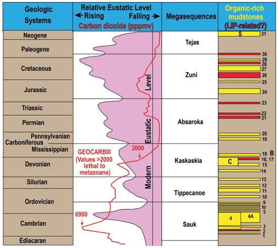
Figure 1.
Phanerozoic organic mudstones. Section 2.2 and Section 4 discuss this figure. Most organic-rich intervals in [11,12]; eustatic curves of [13,14], mega-sequences in [15].
Figure 1.
Phanerozoic organic mudstones. Section 2.2 and Section 4 discuss this figure. Most organic-rich intervals in [11,12]; eustatic curves of [13,14], mega-sequences in [15].
2. Regionally Extensive Phanerozoic Organic-Rich Marine Mudstones
2.1. Succession of Phanerozoic Black Mudstones on Continents and in the Ocean
Black shale intervals representing variable time intervals occur through the Phanerozoic, particularly in the Paleozoic through the lower Tertiary (Figure 1). Most have been listed in earlier syntheses [11,12,16], but they have been supplemented by additional intervals documented on several paleocontinents in the Cambrian–Lower Ordovician [17,18,19,20,21,22]. Almost all of the black shale intervals in Figure 1 were deposited on, or marginal to, paleocontinents, with only the later Tertiary black sapropels deposited as deep-water facies of the Mediterranean and Black Sea (Figure 1, “S”). These sapropels correspond to the traditional deep-water/silled basin “Black Sea model” for ancient black mudstone deposition used in many reports [23] (Figure 2a).

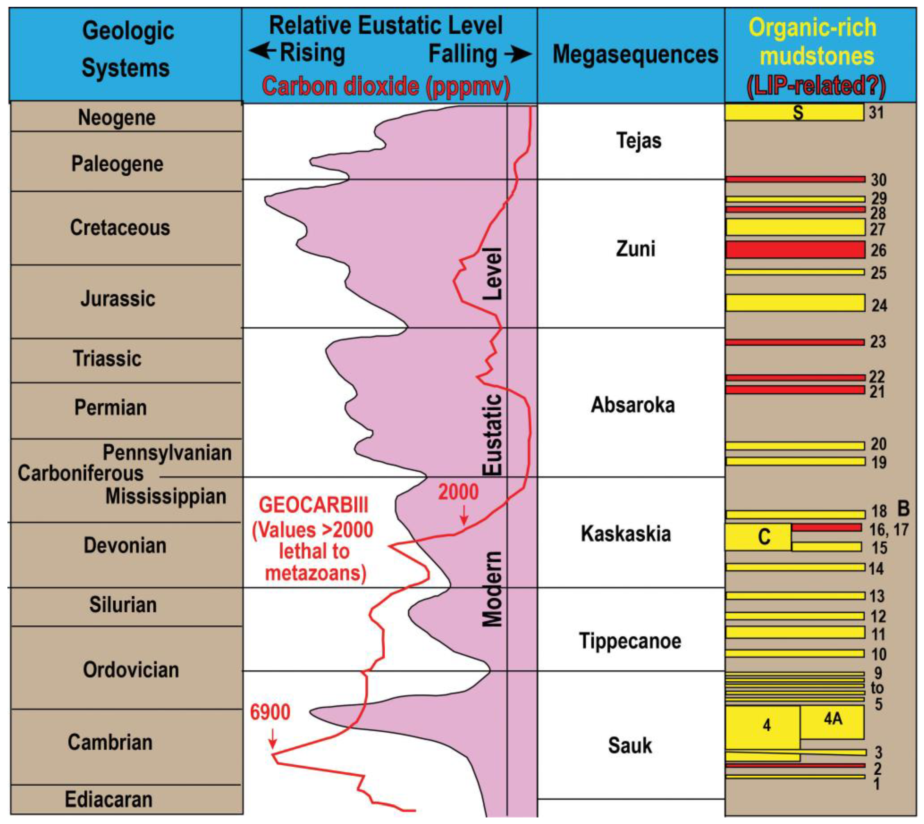
Figure 2.
Models for marine organic-rich mudstone deposition: (a) Black Sea (silled basin model); (b) Bakken model featuring origin of strongly dysoxic/anoxic facies in shallow water and transgression with sea-level rise, either eustatic or epeirogenic; the model corresponds to the near-shore transgressive model [16] and with photic zone euxinia [17].
This review is largely limited to the early Paleozoic. Some of the black shale intervals described below, beginning as early as the Cambrian, can be shown to occur on a number of paleocontinents. Similarly, a number of marginal black shale oxygen-minimum zones (OMZs) can be temporally linked to on-platform (Bakken) black shales or to coeval, unconformity-bounded depositional sequences on tropical paleocontinents [12,13,14,15,16,17,18,24].
2.2. Bakken Model for Shallow-Marine Black Shale Deposition
The designation “Bakken” is derived from the shallow-marine Late Devonian and lower Carboniferous (lower Tournaisian) Bakken Formation in the Williston Basin or the western US and adjacent Canada ([6,22], Figure 1, intervals 17, 18).
Organic-rich black mudstones occur in a wide variety of marine depositional environments. These include marginal facies deposited under an oxygen-minimum zone (OMZ) known to develop with or without upwelling in marginal and upper slope environments (Figure 2b). OMZ black shales may be coeval with shallow, anoxic/dysoxic Bakken-type shale facies on the platform as eustatic rise is accompanied by the thickening and intensification of the OMZ. However, expansion of the OMZ is not regarded as leading to the onlap of OMZ water onto the shelf of a paleocontinent (Figure 3b). The distinction is that the Bakken model has been proposed for shallow, often peritidal organic-rich shale deposition, with Bakken organic-rich facies arising via the de novo origin of low-oxygen facies with eustatic or epeirogenic onlap of shallow sea water. The model likely features the proposed heating of onlapping/transgressing waters during regional onlaps that replace higher-albedo land surfaces with higher insolation, heat-trapping shallow waters with lowered oxygen solubility due to their high temperatures, and likely with photic zone algal proliferation and the sinking of organic detritus (Figure 2b [6,17,18,19,20,21,22,23,24]).
Figure 3.
Depositional models for marine organic-rich mudstone: Global hyper-warming model for eustatic lowstand (a) and highstand (b) showing litho- and biofacies patterns and changes in mid-water oxygen-minimum zones, with Bakken facies unrelated to OMZ transgression in the Cambrian–Ordovician and developing as Bakken facies with the hyper-warming of the shelf; (c) development of Bakken facies on shelf unrelated to the expansion of anoxic puddle limited to on-shelf basin.
The Bakken model resembles the expanding anoxic “puddle” for the origin of organic-rich facies on continental platforms with sea-level rise [25,26], but with the “puddle” not originating with the transgression of OMZ water from the shelf margin (Figure 2b and Figure 3a–c).
The Bakken model for the hallow-marine deposition of organic-rich mudstones is an alternative to several existing models for the origin of these facies. As noted above, the Bakken facies is only coeval with an expanded, thickened OMZ at times of high sea-level; it does not represent the onlap of the OMZ, as in frequently cited traditional models [27]. Indeed, modern shallow-shelf onlaps of marginal OMZs are unknown and do not seem physically possible (Section 2.5).
A second model for the origin of organic-rich mudstones proposes the deep subsidence of parts of paleocontinents that otherwise are not involved in orogeny or known epeirogenic activity (Figure 2a). This includes the Cambrian Alum Shale deposition described below (Figure 1, interval 4a).
Finally, anoxic black mudstone facies have appeared, particularly in the Mesozoic–early Tertiary (Figure 1), with major oceanic changes (i.e., OAEs, oxygen anoxic events). These ocean-wide intervals result in the deposition of black muds in pelagic facies to bathyal depths and are correlated with the origin of dysoxic/anoxic (Bakken) intervals in paleocontinental successions [27].
2.3. Cold Water Upwelling and Deep-Water Organic-Rich Mudstones in Early Paleozoic Forearc Troughs
The Bakken model is an alternative to proposals of black shale deposition during orogeny that have proposed the upwelling of deep, poorly oxygenated marine water into Paleozoic forearc troughs that led to the production and preservation of organic-rich mud. As much as a kilometer of rapid subsidence in Paleozoic fore-arc troughs in eastern North America has been presumed in these models.
The upwelling has been regarded as possibly wind-driven, which entrained cold, low-oxygen marginal waters into elongate (1000+ km) forearc troughs during the Taconian (Late Ordovician) [28,29] and Acadian (Middle–Late Devonian) [30,31,32] orogenies.
An alternative explanation to deep-water fore-arc black shale deposition is needed as no modern forearc regime features deep-water, low-oxygen deposition. In some cases, this may be due to the rapid accumulation and aggradation of orogen-derived sediment that keeps modern fore arc troughs relatively shallow. Indeed, an ancient example involving forearc syndepositional mud- and sandstones immediately in front of and under the leading edge of the Taconian fore-arc thrusts suggests depths of only tens of meters [33].
2.4. Pre-Latest Ordovician Cold-Water and Glaciations
Wind-driven upwelling of deep- and cool-water low-oxygen OMZ facies in synorogenic fore-arc facies has been suggested to play a part in the formation of Late Ordovician and Late Devonian black shales across the eastern U.S. at the margin of, or in-board of, the Appalachian Mountains [31,34]. This model proposes the appearance of supposed cool-water carbonates, as shown by phosphate lag and manganese deposits and the replacement of coral by bryozoan biofacies [30,31,34]. An alternative explanation of these “cool water” developments is that they reflect the replacement of coral by bryozoan biofacies in turbid water sedimentary condensation and the development of sediment-laden water that led to surface water algal blooms, to the development of benthic cyanobacterial mats, and to the accumulation of organic-rich mud [35,36,37]. Indeed, the origin of carbon from cyanobacterial or algal sources probably explains the low δ 13Corg values of Phanerozoic black shales [12].
One key suggested ingredient of onlap models, such as in the late Middle–Late Ordovician, is cold, low-oxygen OMZ water. This water was purportedly drawn into and became the bottom water mass of the successive synorogenic, late Middle–middle Late Ordovician Sevier and Sebree fore arc troughs in eastern Laurentia. This cold water is said to have been produced by the possible cooling or glaciations before the brief (ca. < 1 Ma) terminal Ordovician Hirnantian glaciations across Gondwana [38].
Pre-latest Ordovician glaciations have been discussed based on rapid, presumed eustatic changes in Jordan [39]. However, no physical evidence for these glaciations has been found [40]. A caveat to proposing glaciation is that rapid third-and fourth-order eustatic changes cannot be assumed to be glacioeustatic. Indeed, 100 Ka, 405 Ka, 1.2 Ma, 2.4 Ma, and 3.0 Ma sea level changes correspond to obliquity and thus humid–arid cycles in a time with no glaciation (the Cretaceous). As a result, short-term eustatic changes actually track storage of water in global aquifers [41]. The takeaway is that the production and onlap of cold dysoxic/anoxic waters cannot be imagined to be an element of the extensive transcontinental Utica Shale Bakken facies (discussed below) or onlaps of other shales during times with no or limited polar glaciation (e.g., Cambrian, most of Ordovician, later Silurian, Mesozoic and lower Paleogene) (Figure 1).
The one key ingredient in the explanation of shallow-water (Bakken facies) or marginal black shale facies is obviously the depositional significance of siliciclastic mud, which can be moved by waves and currents for greater or smaller distances (depending on steep vs gentle basin paleoslopes) [39]. Subaerial erosion was the obvious source of mud in the widespread Late Ordovician and Middle–Late Devonian black shales in Laurentia (Figure 1, intervals 10, 11) [32,42,43,44]. An often overlooked additional consequence of muddy, turbid water would be that it would reduce the depth and intensity of light in the euphotic zone and would promote low oxygenation in extensive seas that already had lowered oxygen solubility at times of high global temperatures [18].
2.5. Is Upwelling Plausible in Formation of Platform or Forearc Trough Black Shales?
The equation of this thin black shales on continents (Section 3) with upwelling that drove water from an OMZ across tens of kilometres of shallow carbonate shelf seems unlikely [42]. Indeed, upwelling is also invoked in many reports [29,45,46] to explain low-oxygen black mudstones and supposed “high productivity” in very elongate (>1000 km) forearc troughs that traversed the Laurentia paleocontinent in the later Ordovician.
However, no modern or Pleistocene examples of upwelling across very wide shelves exist. All examples of upwelling driven by trade or long-shore winds do not show OMZ water onlapping far across the continental shelf margin, and no examples of such nutrient-rich water reaching into near-shore environments exist. Thus, the powerful Gulf Stream only episodically crosses the northern Florida–North Carolinas shelf margin but remains 70–100 k offshore, with upwelling limited to shelf depths of 30–70 m [47]. Similarly, a review around all of North America showed upwelling water masses crossing the continental shelf only to depths of 40–120 m [48]. Theoretical calculations of upwelling [49] do not show upwelling crossing the shelf margin, with most upwelling actually being 50–250 km offshore and seaward of the shelf break [47,50].
If an OMZ were actually to cross a shelf break and enter the Ordovician Sevier and Sebree forearc troughs (discussed below), any significant along-trough flow would be precluded. Physical limitations (e.g., internal friction with the shelf floor and between water masses; thermohaline density contrasts of shelf and onlap water) would seem to preclude such regional upwelling models [45]. The locations of the mouths of the Sevier and Sebree troughs were at low southern latitudes at the margin of Iapetus [32,34]. These locations would have allowed for westerly movement of the surface water under the action of trade winds, as well as for southerly transport via Ekman transport and the Coriolis effect, and would thus be the “perfect” conditions for upwelling. However, both the physical limitations imposed on upwelling into the troughs [45] and the likely shallow depths of the Sevier and Sebreee troughs, with likely frictional and density constraints on the movement of wind-driven Eckman transport of upwelling water into a forearc trough (discussed below), limit the possibility of any deep offshore water (OMZ or otherwise) entered the forearc troughs.
Early Paleozoic Laurentia, Baltica, Avalonia, and South China had black marine shales (Figure 1, intervals 1–9, discussed below) as onlapping platform deposits on older oxic facies. These platform Bakken shales either developed following the “anoxic puddle” model (Figure 3c) or reflect the development of hyper-warming as a consequence of regional marine onlaps. Black shale facies in Laurentian forearc troughs (Figure 1, intervals 10, 11) also involved development on a tropical paleocontinent. In all cases, the low-oxygen black muds were deposited under turbid water due to phytoplankton growth, with the forearc trough water infused with mud derived from the eroding mountain belts [32]. In all these cases, black mudstone deposition was likely associated with the heating of shallow water and the resulting diminished oxygen solubility in lower latitudes [18].
2.6. Role of Global Temperatures in Black Mudstone Deposition
Figure 1 follows Hallam’s [13] eustatic curve and shows the long-appreciated association of black shale deposition with sea-level rises and onlap [14]. The major craton-wide transgressive intervals of North America are Sloss’ [15] (mega)sequences. The history of pCO2 is taken from the GEOCARBIII proposal [51]. Black d/a mud deposition is said in many reports to be regularly associated with high eustatic level, high global temperatures, and high pCO2. However, some aspects of these syntheses have to be questioned.
Indeed, a negative correlation exists between global temperatures and pCO2 [52], and the sensitivity of proxies for published levels of temperature and pCO2 should be regarded as uncertain. An unquestioned factor in paleoclimate reconstruction is the very high pCO2 levels in many Phanerozoic reports. It is significant that even at the modern ca. 420 PPM pCO2, Arctic and tropical oceans are losing their bicarbonate buffering capability. This means that aragonite is becoming soluble, with plants and animals losing the ability to precipitate it. At the very questionable 1000–7000 PPM levels reconstructed by GEOCARB III (Figure 1), bacteria would undergo DNA damage, while higher levels are associated with kidney damage and calcification and bone degradation in vertebrates [53,54].
Thus, significantly lower pCO2 levels through the Phanerozoic, with maximum levels of 2000 PPM [55,56], may be more accurate, with the proviso noted above that there may be no systematic correspondence of pCO2 with climate temperature variations [52,55]. This agreement of Jackson Davis [52] and Rothman [55] actually demonstrates what has been known from the “dawn” of the role of atmospheric pCO2 in temperature regulation in 1896; i.e., that levels above 1000 PPM do not progressively or significantly increase atmospheric temperatures [57]. This limited control of global temperatures with the rise of pCO2 leads to a necessary questioning of the presumed consequence of increased pCO2 levels with large igneous province (LIP) activity.
Higher global temperatures have traditionally been associated with large igneous province (LIP) activity and consequent high atmospheric pCO2 levels [12,58,59]. However, in addition to the plausible negative association of temperature and pCO2, this presumed association of LIP activity and temperatures is problematic given the limited temporal resolution of individual 40Ar/39Ar dates (commonly ±4 Ma) and long duration of LIP events [60]. In short, the role of LIPs in the occurrence of black shale intervals (see organic-rich shales shown in red in Figure 1) is questionable as most LIPs cannot be unquestionably associated with a particular black mudstone interval.
3. Black Shales and Bakken Facies Through the Early Paleozoic
Almost all early Paleozoic marine successions deposited off early Paleozoic paleocontinents have been lost to subduction or are highly metamorphosed in orogenic belts. The best-preserved early Paleozoic continental slope successions occur in the Taconian overthrust belt in NE North America, i.e., from western Pennsylvania into eastern New York State and western Vermont and then extending from southern Quebec to western Newfoundland. These slope successions preserve a record of the oxygenation of the Iapetus Ocean off the margin of Laurentia and provide a standard of comparison for oceanic oxygenation of much of the early Paleozoic.
In this region, upper–middle-slope OMZ intervals are best known from the leading edge of the Taconic overthrust belt in eastern New York and southern Quebec, south of the St. Lawrence River. In eastern New York and Vermont, they are exposed in the narrow (ca. 20–60 km-wide), outermost thrust slices (i.e., Sunset Point and Giddings Brook slices) [22,61]. A brief summary of Taconian successions is that coarse grained, feldspathic sandy, rift deposition continued into the late Early Cambrian (estimated ca. 510 Ma). The rift-related facies is followed by six third-order alternations of green and black mudstone-dominated intervals. All known black mudstone OMZ localities from eastern Pennsylvania to western Newfoundland, with their correlations into Laurentian carbonate platform units and into all early Paleozoic paleocontinents, have been discussed [18].
The black OMZ intervals may be slightly calcareous, are strongly dysoxic to anoxic with small and limited burrows, and they commonly have thin, nodular-to-bedded turbiditic and contourite limestones and debris flows composed of slope-derived limestones in the Cambrian–lower Middle Ordovician (Figure 1, intervals 3–9, 3a, b). The onset of the Taconian orogeny in NE Laurentian is marked by a lowest Upper Ordovician (Nemagraptus gracilis Zone) black mudstone and then by a middle Upper Ordovician OMZ, with black mudstone and abundant sandstones being derived from the encroaching Taconian accretionary prism (Figure 1, horizons 10, 11). Relatively thin black mudstones (Figure 1, OMZ intervals 5–9) are intercalated with the Lower–lower Middle Cambrian green mudstone alteration.
3.1. Cambrian Black Shales and Bakken Facies
3.1.1. Lowest Cambrian
Deposition of black mudstones of the Lower Cambrian Shuijingtuo Formation (Figure 1, interval 1) began at ca. 526 Ma at about the beginning of Stage 2 [62]. This black mudstone is older than the earliest black mudstone in the Taconic overthrusts. The low-energy shelf facies of the formation blankets a huge area of the SE part of the South China Platform, but its possible lateral continuation into slope facies and into an OMZ is not recorded. Relatively little data are available to allow for the determination of whether this is a shallow (i.e., Bakken facies) or relatively deep water unit. No coeval black mudstones on other paleocontinents seem to have been described.
3.1.2. Browns Pond Dysaerobic/Anoxic Interval and Sinsk Event
Three Lower-Cambrian black mudstones (Figure 1, interval 2) that may be coeval include the OMZ black shale of the Browns Pond d/a interval in the Taconic allochthon of eastern New York [18,22]. The Browns Pond interval, with the Moosamaloo Shale, correlates with Cheshire Quartzite and overlying Dunham Dolostone onlap of the east New York–west Vermont shelf and is referable to Cambrian Series 2, upper Stage 3–4 [61].
A tentative correlation of Stage 3–4 is with organic-rich mudstones of the Sinsk Formation [63], which forms an extensive, relatively shallow Bakken facies on the SE Siberia paleocontinent [64,65]. This black shale facies was deposited in the photic zone [66].
A ca. 507.7 U-Pb volcanic zircon date on the Callavia broeggeri Zone (Stage 3–4) in Avalonian SE Newfoundland [67] may be younger than the Sinsk Formation, which records the Sinsk event and the extirpations of archaeocyaths and trilobites. A black shale unit occurs immediately below molasse of the Ross-Delamerian orogeny in SW Australia and in the Ross Peninsula of Antarctica. Based on associated trilobites, this East Gondwanan shale is correlated with the Sinsk Formation [68]. Dates on volcanics of the Kalkarindji LIP of northern and central Australia were used to propose an age of ca. 510–511 Ma. This date is older than the ca. 507.7 Ma on the C. broeggeri Zone, but it may be accurate based on the relatively low-resolution 40Ar/39Ar ages that cluster around 510 Ma, with a resolution of ±4 Ma [61]. The possible association of the Sinsk-Ross/Delamerian black mudstones with an LIP event is indicated by the red color proposed in Figure 1, horizon 2.
3.1.3. Lower–Middle Cambrian Boundary Interval
Black mudstones occur in the Lower–Middle Cambrian boundary interval (Figure 1, interval 3). These mudstones yield the lowest Middle Cambrian trilobites, including what is cautiously regarded as the long-ranging, dysoxia-associated Oryctocephala indicus-plexus, used to recognize the base of the Middle Cambrian/“Miaolingian Stage”, and they have been discussed by Landing et al. [67]. In South China, the mudstone occurs at the base of a meter-scale shaly, calcareous redox alternation termed a Logan cycle in early Paleozoic ramp and slope successions [18,22]. This succession was deposited in what appears to be a dysoxic upper slope succession [67]. In SW Laurentia, the Oryctocephala indicus-plexus and a low-diversity trilobite assemblage have a lowest occurrence with the onlap of dark mudstones across platform sandstones in SE California and SW Nevada. Limited details of the facies are available, but the Laurentian occurrences may record the development of a shallow-marine Bakken facies. Finally, the type of locality of the lowest Middle Cambrian Oryctocephala indicus-plexus is in dark mudstones that abruptly overlie a subaerial unconformity surface [68,69], which is best interpreted as the abrupt onlap of shallow-water of a low-oxygen Bakken facies. Via their interpretation, and with no supporting biostratigraphy, Jiang et al. [60] interpreted their ca. 511–510 Ma age on the Kalkarindji LIP as the Lower–Middle Cambrian boundary age. A more precise bracket on the boundary is 507.7–506.6 Ma [67], with the ±4 Ma resolution of the Kalkarindji date overlapping a possible age for the Sinsk organic-rich mudstones.
3.1.4. Later Cambrian–Lowest Ordovician Boundary Interval Hatch Hill d/a and Alum Shale Intervals
Two distinct major organic-rich mudstones characterize the later Cambrian–lowest Ordovician (lower Tremadocian) on a number of paleocontinents. The Hatch Hill d/a interval (Figure 1, interval 4) in the Taconian allochthons of eastern New York, along the St. Lawrence River of southern Quebec, and western Newfoundland, is a long-term (late Early Cambrian–early Tremadocian) composite OMZ [18]. The designation “composite” is used for this heterogeneous association of black shales with slope-derived, carbonate clast debris flows, turbiditic sandstones, and local thin-bedded (“ribbon”) limestones. This “composite” interval likely consists of a succession of macroscale sequences linked to local epeirogenic sea-level and eustatic changes. Thus, evidence for possible eustatic changes in the Lower–Middle Cambrian boundary interval, traditionally termed the global “Hawke Bay regression” but re-interpreted as a local epeirogenic slowdown in the epeirogenic subsidence rate in its “type” area of NE Laurentia [22], remains unknown in the Hatch Hill interval.
The Hatch Hill d/a interval is recognized in the parautochthonous Franklin Basin in NW Vermont, which is located north of the Taconic allochthon in eastern New York. The Franklin Basin originated in the late Early Cambrian via the abrupt foundering of the ENE-trending Ottawa aulacogen, which is the passive arm of the triple junction that defined the eastern NY–St. Lawrence River embayment of NE Laurentia [70]. This foundering also extended along strike into the Vermont passive margin shelf, which rapidly subsided to form the Franklin Basin. Indeed, Early Cambrian peritidal carbonate platform carbonates (Dunham Formation) are abruptly overlain by strongly anoxic/dysoxic black shales [61]. The late Early Cambrian–Upper Cambrian succession of black slate-dominated units in the Franklin Basin (i.e., Parker-St. Albans, Skeels Corners, Humgerford, Gorge formations [71]) is likely an upper-slope sequence of the Browns Pond dysoxic-anoxic interval OMZ, with the Gorge Formation likely deposited at a depth of only ca. 100 m [72].
The second later Cambrian–lowest Ordovician interval of organic-rich shale deposition (Figure 1, interval 4a) is a Bakken facies known on several paleocontinents. It has a later onset (middle Middle Cambrian) than the Laurentian Hatch Hill OMZ but also persists into the early Tremadocian for a ca. 26 Ma duration [21]. Interval 4a includes the Alum Shale in southern Scandinavia, the Baltic states, and adjacent Russia and Poland. The coeval interval on the Avalonia paleocontinent in NE North America and southern Britain is a regionally extensive succession of three unconformably bounded units. In North American Avalonia, these are the successive Manuels River Formation (black mudstones), the McLean Brook Group (black mudstones and thin shelf sandstones), and the black mudstone-dominated Chesley Drive Group [21,69,73]. The Alum Shale TOC in southern Norway is high and was used as a petroleum source in World War II.
The onset of interval 4a deposition is essentially simultaneous in Avalonia and Baltica (i.e., within the seemingly short upper Ptychagnostus gibbus Zone as defined in Baltica) [21]. Initial deposition of 4a was often initiated on an unconformity surface with initial shoreline sediments composed of black muds and even highly pyritic remané sandstone (Figure 4a,b). Although a number of reports have traditionally regarded the Alum Shale and other organic-rich black shales as a deep shelf facies (150–900 m) [74,75], a shallow-marine origin is suggested by evidence for photosynthetic activity, i.e., both benthic algal mats [76,77] and stromatolites with cyanobacterial filaments, as well as possible algal mats on large calcite crystals that grew on the sea floor [78,79].

Figure 4.
Unconformable subaerial onlaps of Cambrian Bakken black shales: (a) Alum Shale on Archaen at Slemmmertad, Oslofjord, southern Norway (from Creative Commons Attribution 2.5 Generic License, by J.O.R. Ebbestad and E. Sundring); (b) Basal pyritic remané sandstone, feather edge of upper Middle Cambrian Cavendish Formation, bed 125 of Howell [79], on Manuels River Formation, Manuels River, southeastern Newfoundland. Sandstone has a basal thin layer of coarse quartz sand and caliche fabrics (cpf, undifferentiated crystic plasmic fabric; shc, subhorizontal cracks). The golden area at the lower right is a mixture of caliche and fine-grained, euhedral pyrite. Orthothecid hyolith conch (or) and trilobite (tr) fragments. Scale bar = 1 cm.
The Alum Shale is a superb example of the “expanding puddle model” by which the areal extent of a low-oxygen, organic-rich water mass expands laterally across the shelf with the rise in sea level [25] (Figure 3c). Indeed, the Alum Shale progressively onlaps to the north and northeast through the Late Cambrian [80]. This cumulative onlap was not continuous and the Alum Shale shows numerous offlaps, often marked by calcareous nodules and nodular limestones prior to its further onlap directly across these unconformity surfaces [81].
A surprising development in the Alum Shale is a number of erosional surfaces with karstic cavities that record subaerial exposure [82]. As noted above (Figure 5), a similar development of subaerial exposure and weathering occurs in the black mudstones of the Upper Cambrian Chesley Drive Group of Cape Breton Island, Nova Scotia [83]. The Nova Scotia occurrence shows the development of an unconformity surface mantled with eroded limestone nodules, black mudstone clasts, phosphate nodules, and brachiopod and trilobite debris cut by caliche-lined fractures (Figure 5).

Figure 5.
Caliche development in subaerially exposed, shallow-marine (Bakkan facies) black mudstone with carbonate and dark mudstone clasts and dyke of pyritic (psm) filling intraclast space in the Upper Cambrian Chesley Drive Group, Cape Breton Island, eastern Canada [82]. (a) and (b) show large, dark grey, fine-grained, diagenetic calcareous nodules at the top of the bed (cns) and lenses of phosphatic sand and granules (ph) and pyrite sand (ps) that yielded Leptoplastus cf. ovatus trilobite sclerites. The lower part of the figure depicts clasts of non-fossiliferous, light-to-medium grey, laminar caliche hardpan caliche (cal) composed of microsparitic carbonate laminae with quartz sand (small white grains), scattered darker grey glaebules (gl), and sub-horizontal, caliche calcite spar (scr). Small pebbles include rounded white clasts dominated by syntaxial calcite rims (sc) and sparry (bladed) calcite (bs) that envelope fragments of black siliciclastic mudstone and caliche. Pyritic siliciclastic mudstone (psm) dyke fills interclast space.
In short, the upper part of the Cambrian–lowest Ordovician, lower Tremadocian not only features a black mudstone-dominated OMZ (Hatch Hill d/a interval) off NE Laurentia but also a shallow-shelf black shale Bakken facies in Baltica and Avalonia. These persistent, major black shale successions roughly correspond to high eustatic levels (Figure 1, intervals 4, 4a) which, at their maximum, covered all of the Avalonian platform and much of southern Scandinavia and the East European platform in shallow-water black mud. Coeval Laurentia, except for shallow sandstones of the northern Mississippi River valley region, was blanketed by shelf carbonates.
3.2. Lower–Lower Middle Ordovician OMZ Black Shales and Coeval Bakken Facies
A basis for the correlation of Lower–lower Middle Ordovician OMZ black shales and shallow-water Bakken facies is provided via the conodont-based biostratigraphy of successions in the Taconic allochthons from eastern Pennsylvania and eastern New York through western Newfoundland. As noted above, the Taconian allochthons preserve the only remaining, unambiguous continental slope sequences of the early Paleozoic. This is a greenish mudstone-dominated stratigraphic interval with five named black mudstone OMZ intervals [18,22,61] (Figure 1, intervals 5–9).
This interval ends with the deposition of a condensed, upper Middle Ordovician red mudstone with radiolarian cherts and volcanic ashes from the Taconic arc. This red mudstone (Indian River Formation in the Taconian allochthon of eastern New York and western Vermont) reflects passage of the peripheral bulge in front of the advancing Taconic arc and accretionary prism [25,61,84]. Volcanic ashes give U-Pb zircon dates of ca. 466.2–464.2 Ma on the Indian River Formation [85] and allow for correlation into the middle Darriwillian Stage, which comprises the unconformity bounded Chazy Group carbonates (base of Tippeecanoe Megasequence, Figure 1) on the eastern New York platform.
The five successive mesoscale OMZ black shales (Figure 1, intervals 5–9) in the greenish mudstone-dominated, Lower–lower Middle Ordovician of the Taconian overthrust belt are geographically limited. They occur at or within several km inboard of the leading edge of the outermost thrust sheet of the Taconian allochthon in eastern NY–western Vermont and along the south shore of St. Lawrence River in Quebec. These OMZs cannot be recognized further east or SE even within the outermost thrust and seem to lens out away from the upper slope. Three of the OMZs (Figure 1, intervals 5–7) are known to occur on the upper slope, such as at Levis, Quebec, where wave ripples occur on the top of carbonate clast debris flows [86].
Almost every one of the relatively thin (1–15 m) black shale OMZs can be correlated biostratigraphically with a eustatic onlap that defines one of the unconformity-bounded formations of the Beekmantown Group on the eastern New York–western Vermont shelf. These carbonate-dominated formations were also the sources for thin-bedded (“ribbon”) turbiditic (easterly transport) and contourite limestones that occur in the upper part of the five OMZ black shales [18,22,61]. As each of the OMZ black shales can be correlated onto another paleocontinent, they are regarded as eustatic records through the earlier Ordovician [18,61].
The succession and global correlation of Lower–lower Middle Ordovician mesoscale black OMZs (Figure 1, intervals 5–9), as earlier detailed [15,61], include the following.
3.2.1. Schaghticoke d/a Interval
The upper lower Tremadocian Schaghticoke d/a interval (Figure 1, interval 5) is correlated with the trans-Laurentian Stonehenge transgression [87]. The Schaghticoke d/a OMZ correlates across Laurentia with carbonate platform units that unconformably overlie the Upper Cambrian such as the Tribes Hill Formation in eastern New York, Oneota Dolostone in the upper Mississippi River valley, and Manitou Formation in the Colorado Rocky Mountains. The middle of the Tribes Hill Formation is a 1–3 m thick mudstone (Van Wie Member) that changes from black to light grey over a 60 km E–W distance in eastern New York. The presence of a mollusk-dominated limestone without deeper-marine faunal elements (i.e., trilobites) under the Van Wie; the 25 cm thick, wave-rippled carbonate sand at its base; and the massive thrombolite cap all suggest a shallow-marine, Bakken facies for the Van Wie Member.
That this thin black shale with upwelling drove water from an OMZ across tens of kilometers of shallow carbonate shelf seems unlikely (discussed above [45]).
3.2.2. Rte. 299 d/a Interval
A second OMZ black mudstone (Figure 1, interval 6) associated with sea level rise is the late (but not latest) Tremadocian Rte. 299 d/a interval (Laurentian Macerodus dianae Zone, conodonts). This OMZ is known only from the Taconian allochthon in southern Quebec [18,61]. On the NE Laurentian platform, it includes carbonate platform units with basal unconformities in western Newfoundland (middle Boat Harbour Formation), the Ottawa aulacogen (Theresa Formation), eastern New York (Rochdale Formation and its junior synonym the “Fort Ann Formation”), and an unnamed black shale and limestone interval in the outer shelf of the Frederick valley, central Maryland [88]. The Rte. 299 d/a interval could also mark a transgression driven by strong epeirogenic subsidence in NE Laurentia as it does not seem to be present on other paleocontinents.
3.2.3. Levis d/a Interval
The Levis d/a OMZ (Figure 1, interval 7) is widespread in the Taconian allochthons of eastern Pennsylvania, New York, and Quebec, but coeval shelf black shales are not known. This OMZ brackets the Tremadocian–Floian boundary interval (Laurentian upper Acodus deltatus Zone, conodonts). There is no shelf equivalent in eastern New York, but this interval includes “cycle 3” in the middle Rockdale Run Formation, central Maryland shelf [88]; the unconformity bounded middle Boat Harbour Formation, western Newfoundland shelf; the Kinblade Formation on the Arkansas shelf; and the Billingen onlap (,) in Baltica [18,61,89].
3.2.4. Laignet Point d/a Interval
The Laignet Point d/a OMZ (Figure 1, interval 8) records a strong sea level rise in the upper Lower Ordovician (Floian) across eastern Laurentia from northern Greenland and western Newfoundland to eastern New York (Fort Cassin Formation). This strong sea level rise includes the stratigraphically abrupt appearance of Bakken facies-type black shale deposit (Didymograptus protobifidus Zone, graptolites) on the Laurentian platform and outer shelf in Arkansas, Oklahoma, Nevada, and western Utah. It is correlated with the Oepikodus evae drowning event in Baltica [89], with the occurrence on two paleocontinents showing it to be eustatic [18,61].
3.2.5. Raceville d/a Interval
The Raceville d/a interval is the highest OMZ in the Taconian allochthons before the onset of the Taconian orogeny in the Appalachians SW of western Newfoundland (Figure 1, interval 9). This OMZ and its carbonate platform equivalents are lower—but not the lowest—Middle Ordovician units (middle Dapingian–lower Darriwillian stages), as shown by the bracketing by graptolites that go as low as the Isograptus gibberulus Zone, with Undulograptus austrodentatus Zone graptolites at its top. The Raceville OMZ correlates with onlaps of carbonate platform units with basal unconformities in western Newfoundland (upper Aguathuna Formation); New York, Vermont, and adjacent Quebec (Providence Island Formation and junior synonyms Carillon and Bridport formations); and Joins Formation in Oklahoma [22,61]. The Raceville OMZ was likely associated with earliest Middle Ordovician eustatic rise given the appearance of the slightly older bases of the petroliferous Kanosh Shale in the Ibex area, west-central Utah [90], and the correlative “basal Llanvirnian drowning event” in Baltica [89].
3.3. Upper Ordovician Black Shales
Two Late Ordovician black shale OMZs occur in the Taconian allochthon of eastern New York. These OMZs occur above the upper Middle Ordovician red mudstones of the Indian River Formation (discussed above) and record synorogenic developments on the east Laurentian slope during the onset of the Taconian orogeny [19,61].
3.3.1. Glenmont d/a Interval
The lower unit is the Glenmont d/a (Figure 1, interval 10), which is a black shale interval in the dominantly greenish mudstones of the Mount Merino Formation. The Glenmont d/a has the classic graptolites of the Normanskill Group in eastern New York [91]. These graptolites (Climacograptus bicornis Zone) indicate a correlation into the unconformity-bounded Black River Group carbonates on the New York shelf and coeval carbonates across Laurentia [18,22,61].
3.3.2. Mohawkian d/a Interval
The higher Mohawkian d/a interval (Figure 1, interval 11) [18,61] is a long interval in the Upper Ordovician. Its lower part includes the black mudstone and turbiditic sandstones in synorogenic flysch. This trench fill is the highest unit (Austin Glen Formation, upper Climacograptus bicornis—at least Corynoides americanus zones) in the Taconic allochthon of eastern New York [92]. The Austin Glen reflects rapid burial and deposition under a low-oxygen water mass in the early Upper Ordovician (Sandbian and lower Katian stages). These d/a conditions spread onto the eastern margin of Laurentia with the foundering of the forearc region as the allochthonous Taconian orogen (i.e., accretionary prism and volcanic arc) moved on to eastern New York.
Erosion of the moving and subaerially emergent allochthon led to the deposition of synorogenic fore arc sandstones and mudstones (Snake Hill Formation) that are overrun by the allochthon and are difficult to distinguish from the Austin Glen Formation in the allochthon. The Snake Hill has yielded lower Katian graptolites (Orthograptus ruedemanni Zone) and likely overlaps the upper Austin Glen in terms of age [33]. In eastern New York, the synorogenic flysch rapidly changes westward into the black and brown mudstones of the Utica Shale that prograde west through the middle Katian before. With aggradation, they are replaced by overlying shallow-marine shales and sandstones of the Queenston delta that persist to the Ordovician–Silurian boundary unconformity (North American Cherokee unconformity) [92].
The Utica Shale and synonymous units overlie a large area east of the Mississippi River valley and west of the folded and thrust-faulted Taconian belt of the western Appalachian Mountains. Utica Shale facies are the oldest synorogenic siliciclastics in the Martinsburg forearc trough in front of the overthrust belt in southeastern New York– northern Virginia. As a result of erosion with the westward movement and the uplift of the Taconian peripheral bulge, the Utica Shale overlies units as low as Lower Ordovician carbonates, with its western onlap across New York State (Figure 6). With regional extension later in the Taconian orogeny, the NNE striking Sebree trough subsided along basement faults, with the Utica deposited being the lowest synorogenic unit in the trough.
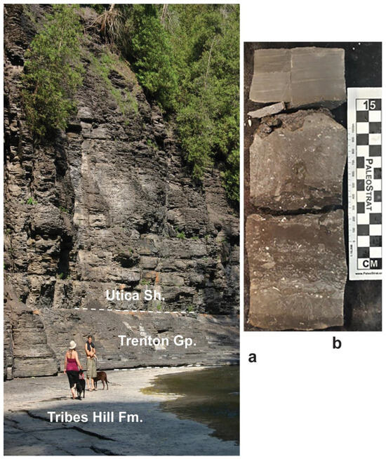
Figure 6.
Utica shale contacts: (a) Succession at Floral Park on Canajoharie Creek, Canajoharie, eastern New York, showing the Upper Ordovician Trenton Group unconformity (dashed white line) on the Lower Ordovician Tribes Hill Formation and Utica Shale unconformity on Trenton; (b) Utica Shale (upper) unconformity on Trenton Group, Bay City core, eastern Michigan, USA (from [93]; Figure 2 and Figure 3, master’s thesis—open access).
4. Upper Ordovician Black Mudstones—Not Deep Water
4.1. Sevier Belt
In eastern North America, two major regional developments of black mudstone deposition took place in the forearcs of two successive stages of the Taconian orogeny. The earlier, or Blountian stage (late Middle Ordovician [late Darriwillian Stage] to early Late Ordovician [Sandbian Stage]), features black mudstones (Athens, Blockhouse, Paperville, Rich Valley shales). These shales were deposited in a long (ca. 1200 km), NNE-trending Sevier belt that extends from northern Alabama and Georgia to southern Virginia [28]. The Sevier belt is a remarkably narrow (to 50 km) belt in the Valley and Ridge province of the western Appalachians.
The stratigraphic and sedimentologic data indicate the very rapid deposition of ca. 2.5 km of black mudstones (>1 m/Ka) with the foundering of a forearc belt. What proves to be an idealized depositional motif is a lateral transition from east to west from dysoxic/anoxic black mudstone to somewhat calcareous shales with limestone turbidites, then to carbonate clast debris flows from a deep shelf, and then a peritidal carbonate shelf [28,94].
The model of an abrupt peritidal–bathyal transition along the Sevier belt is problematic and has no modern analog. To begin with, what is presumed in these stratigraphic and depositional environment summaries [94,95,96,97], as well as the subsequent commentaries on the Sevier belt [28,31], is a Black Sea model with a purported 800–1000 m mudstone deposition depth.
This water depth is problematic because the dominant facies motif along the Sevier trough [25] is actually not a lateral transition from the black shales–turbidites and debris flows–deep shelf to the peritidal limestone; rather, it is generally an upward transition from a peritidal carbonate (Lenoir Limestone) abruptly into black shale at a bedding plane, with this transition being diachronous over several upper Middle and lower Upper Ordovician graptolite and conodont zones along the Sevier belt [28]. In short, the proposed depositional model cannot be a local sudden foundering at sites along the Sevier belt of “~250 to 800 m” [25]; it records a cumulative south-to-north and east-to-west peritidal carbonate–black mudstone facies transition. Again, the designation “local” is used because the peritidal carbonate–black mudstone transition is diachronous and changes by ca. 8 Ma northward along the Sevier belt (see Ordovician geochronology in [98]). The tectonic mechanism for cumulative foundering along a thousand kilometers of the Sevier belt, with no evidence of a down-to-basin faulting of the Lenoir or a turbulent deposition on the Lenoir, is unexplained by a deep-water Black Sea model for black mud deposition.
4.2. Upper Ordovician Utica Shale Black and Brown Mudstones and Sebree Trough
In eastern New York, d/a conditions are shown right in front of the Taconic overthrust by the younger Snake Hill Formation (Corynoides americanus–Orthograptus ruedemanni zones) [91]. One of the few studies that have examined depositional conditions in front of the advancing Taconian overthrust [33] concluded that anoxic/dysoxic black mud deposition likely took place at water depths of a few tens of meters, with black muds rapidly replaced by a shoaling-up sequence that includes turbidite sands and sandstone clast debris flows, higher HCS sandstones, and then shoreface sandstones deposited in front of, and then overrun by, the Taconic allochthon.
Thus, O. ruedemanni Zone graptolites from the black shale of the lower Snake Hill Formation mark the onset of a shoaling-up succession [33]. This shoaling-up succession correlates ca. 120 km west in the Mohawk River valley into an offlap interval where the middle Utica Shale is laterally transitional into turbiditic limestones of the Dolgeville facies and then into the peritidal, shell-hash rich Denley and Steuben limestones [99].
Even younger forearc shales (“Utica Shale” and equivalents) record subsequent onlap and dysoxic/anoxic mud deposition that spread across the Laurentian Midcontinent into the Midwest (i.e., Ohio, Indiana, upper Michigan and north into central Quebec, Canada) [99,100]. The designation “Utica Shale” is effectively a group-level designation in its type-area in New York, where it is divided into the black shale-dominated lower Flat Creek and upper Indian Castle formations [99].
The Utica Shale and synonymous units consequently overlie a large area east of the Mississippi River valley and west of the folded and thrust-faulted Taconian orogenic belt of the western Appalachian Mountains. Utica Shale facies are the oldest synorogenic siliciclastics in the Martinsburg forearc trough in front of the overthrust belt in southeastern New York–northern Virginia. As a result of erosion following the movement of the Taconian peripheral bulge, Utica black shales overlie units as low as Lower Ordovician carbonates, with their onlap across New York State [31].
Simultaneously with the Utica Shale onlap in northerly areas, regional extension in the Taconian orogeny later opened a second fore arc trough called the Sebree trough. The 1000 km long Sebree trough extends from the southern Laurentian margin with the Iapetus Ocean in the Ouachita Mountains region of Oklahoma and persists into Ohio. It parallels the older Sevier trough (discussed above) but is ca. 500 km to the west and has a smaller thickness of organic-rich black shales. Both the Sevier and Sebree troughs opened along old fault lines in the Mesoproterozoic basement of the Laurentia paleocontinent [31].
The Sebree trough records two successive intervals of extension. The older featured organic-rich sediment deposited somewhat earlier in the Late Ordovician (lower Katian Stage) and coeval with shelf carbonates of the Lexington Limestone to the east, the Galena Group to the west, and within and on the Trenton Group on the axis of the trough and to the north. Subsequent uplift and erosion removed this earlier episode of organic-rich deposition, but subsequent subsidence due to regional extension allowed the Utica and coeval units to be deposited in the Sebree trough [34,37].
Studies of depositional environments of the Utica Shale are incomplete by comparison with those on the Middle Paleozoic black shales, which led to the proposal of their shallow-water deposition. The latter include work on the Middle and Upper Devonian in New York State [32,101] (Figure 1, intervals 15–17); the Upper Devonian part of the Chattanooga Shale in the Midcontinent of the U.S. [42,102,103,104] (Figure 1, interval C); and the uppermost Upper Devonian and lowest Mississippian Bakken Shale [6] (Figure 1, intervals 17, 18).
A brief survey of the shallow-marine deposition of the Utica Shale includes features such as unconformities on subaerially exposed older units as low as the Lower Ordovician. This basal Utica Shale unconformity extends laterally east and west into local subaerial unconformity on the lower Upper Ordovician Trenton Group (Figure 6). Similarly, a younger (and second) sub-Utica Shale unconformity is with the uppermost Trenton Group [99].
These unconformities show an abrupt transition into black shale at a bedding plane with transgression of the Utica muddy facies (Figure 6). These contacts may show the mm thicknesses of remané sediment (e.g., phosphatic grains) on eroded surfaces, but these contacts do not feature significant accumulations of reworked/lithified sediment or significant mineralization. If present, such features might suggest that the basal Utica contact represents a long time interval, but their absence is evidence that the contact marks a brief transgressive event featuring dysoxic/anoxic water onlap at the paleoshoreline.
This Bakken-type unconformity, marked by the onlap of anoxic/dysoxic water across a subaerial unconformity, is discussed above for the Cambrian Manuels River and Alum Shale formations (Figure 4b and Figure 5). Similarly, the lowest beds of the Utica locally feature wave-generated cross bedding (Figure 7), ripples, burrowing (indicating at least periodic oxygenation), wave-disarticulated brachiopods, and evidence of algal blooms (i.e., presence of amorphinite). These features are consistent with shallow-marine deposition [43,104,105]. Somewhat surprisingly, ripples, HCS-like beds, and large cross beds are known in black shales, but these are present as the mud formed floccules that behaved similarly and produced bed forms similar to sand grains responding to wave and current control [102,103].

Figure 7.
Lower Whitehouse formation shales (upper Utica Shale equivalent) with wave-cross beds formed on mud floccules. Whitehouse unconformably overlies karstic limestone with corals of the eroded lower Saluda Formation. A 25 mm diameter coin is depicted at contact. Rte. 421 road cut at Madison, Indiana. Photograph courtesy of C.E. Brett.
Once an inundation had taken place, little evidence is available to determine the depth of Utica Shale deposition. Although depths > 150 m are proposed in many reports [29], this is based on the presumed modern analog, i.e., the modern Black Sea [106]. However, Utica Shale thicknesses are rarely more than 100 m and underlie open- shelf, wave-dominated sandstones. This stratigraphic context suggests that Utica facies were relatively shallow. Lateral facies change from Utica Shale mudstones into peritidal carbonates; the Denley and Steuben limestones in central New York State [99] are consistent with, but do not prove, relatively shallow Utica deposition. A suggestion of shallow Utica Shale deposition comes from drill cores along a 300 km, NW–SE transect across the northern Appalachian basin from southern Michigan to western West Virginia [104,105]. The cores show a relatively uniform ca. 400 m thickness of the Trenton Group carbonate shelf and Utica Shale, with the upper Utica onlapping the Trenton. As the Trenton and Utica are bracketed by underlying shallow-water Black River Group carbonates and overlying Cincinnatian limestones, there is no possibility of a Utica depocenter that would accommodate significantly deeper Utica facies [107].
5. Review of Phanerozoic Black Mudstones
Most of the Phanerozoic black shales (i.e., OMZ (marginal oxygen-minimum zones); platform Bakken facies; and OAE (ocean anoxic events)) of Figure 1 have been outlined previously [11,16]. The red bars suggest equation with large igneous province (LIP) activity. The limited temporal resolution of LIP events is limited, and their equation with organic-rich mudstones is tentative [60]. Section 3 and Section 4 of this report describe early Paleozoic dysoxic/anoxic black shale intervals (Figure 1, intervals 1–11).
Post-early Paleozoic black shales include intervals: 12, Llandoverian; 13, Pridolian; 14, Emsian; 15 Givetian, with Bakken facies black mudstones being unconformable on somewhat older limestones as an initial forearc unit in Acadian orogeny, NE Laurentia (Figure 8); 16–17, Frasnian–Famennian black shales [32]; 15–17, Bakken facies [104] of Chattanooga Shale [108]; 16 may correspond to Yakutsk-Viliya LIP; 18, lower Mississippian (lower Tournaisian); 17 and 18, Bakken Formation [6]; 19, core black shales (Bakken facies) of Pennsylvanian cyclothems, U.S. Midcontinent; 20, Gzeliaan (latest Carboniferous) Bakken facies; 21 and 22, Changhsingian (latest Permian) and lower Triassic Bakken facies, likely corresponding to Siberian traps; 23, upper Triassic (Rhaetian)–lower Jurassic correspond to Central Atlantic Magmatic Province; 24, upper lower Jurassic (Toaracian) with T-OAE (e.g., Posidonienschiefer); 25, Upper Jurassic (Oxfordian) OAE and Bakken facies [49]; 26, lowest Cretaceous (Valanginian–Hauterivian) OEA-1a may correspond to Parará-Etendeka LIP; 27, lower Cretaceous (Albian), including OEA 1b and 1c; 28, Cenomanian–Turonian boundary, where OAE-2 may correspond to High Arctic LIP; 29, middle Cretaceous Coniacian–Santonian OAE-3; 30, Paleocene–Eocene boundary (PETM thermal maximum anoxic events), which may correspond to North Atlantic Igneous Province activity; and 31, middle Miocene (Langian)–Modern Mediterranean sapropels (S), Black Sea facies.

Figure 8.
Middle Devonian (early Givetian) unconformity of synorogenic black Marcellus Shale (Figure 1, interval 15) on carbonate platform Onondaga Limestone (grey field in foreground with red arrow). Kaaterskill Creek, Catskill village, eastern New York State. Figure 8 and Figure 9 photographs compliments of C.E. Brett.
6. Discussion
Shallow-marine organic-rich, commonly black mudstones that overlie large tracts of paleocontinents and forearc basins, appear through the Paleozoic and Mesozoic. A consensus does not exist on the change in the Earth systems responsible for the occurrence of these economically important hydrocarbon source rocks. However, the frequently referenced equation of forestation of the land as driving organic-rich Devonian mudstone deposition due to increased nutrient run-off with root penetration and greater soil weathering [109] has to be questioned. Indeed, trans-continental and forearc, organic-rich shale deposition took place in the Cambrian and Ordovician of Baltica, Avalonian, Laurentia, and South China long before the appearance of significant land plants (Figure 1, intervals 1–3, 4a, 5, 8–11).
Trans-continental organic-rich mudstones such as the Late Ordovician Utica Shale and Devonian Chattanooga Shale record sea-level highs (Figure 1), which have been associated with the thickening and expansion of mid-water OMZs on paleocontinent margins. However, the origin of trans-continental organic-rich shales, unlike a number of proposals [1,58,61], likely did not involve the expansion of an OMZ onto shallow shelves (Figure 3b). Indeed, upwellings of marginal water do not cross the shelf break, even with persistent long-shore or offshore winds. Thus, there is a fundamental impossibility of proposals that feature the wind-driven Ekman transport of deeper, low-oxygen, marginal water and the deposition of organic-rich mudstone in forearc basins. A different mechanism for the appearance of black shales as the oldest synorogenic deposits in the east Laurentian late Middle and Late Ordovician Sevier and Sebree troughs is required. In addition, other physical limitations (thermal and salinity density contrast with shelf water; friction during transport of water masses) would likely pose problems for the movement of offshore OMZ water masses onto a paleocontinent’s shelf [45].
The origin of these black shales on a number of paleocontinents (Laurentia, Baltica, Avalonia) and in the Ordovician forearc basins of Laurentia includes the onset of early Paleozoic black shale deposition, sometimes directly on a subaerial unconformity. This unexpected depositional history has no modern analog but is also present in later inundations of unconformity surfaces. A later example is the onlap of the synorogenic, Middle Devonian (Givetian) Marcellus Formation black shale (Figure 1, interval 14) on the somewhat older carbonate platform deposits of the Onondaga Limestone (Figure 8). The duration of the hiatus and initial deposition of the black shale may have been relatively protracted as the mineralization of some unconformity surfaces occurs (Figure 6b). In addition, some of these unconformities may have involved the relatively protracted development of an interval of oxic on-shore facies represented by thin lags of skeletal fragments that were cemented prior to black mud deposition (Figure 9). Another unexpected development is the presence of karstic unconformities and cavities in Late Cambrian Bakken black mudstones in Baltica and Avaonina (Figure 5). The continued shallow water deposition of at least the lower part of these Bakken facies mudstones is shown by HCS and the wave trough cross-bedded structures developed in beds of clay floccules, the photic zone algal mats, and the burrows and shell hash laminae (Figure 7).
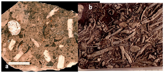
Figure 9.
Remané sediment at base of black shale onlaps, note mm-scales: (a) Middle Devonian (Givetian) Onondaga Limestone–Marcellus Shale contact with phosphatized crinoid fragments, Syracuse, central New York State; (b) Givetian reworked, current-aligned pyritized burrows, Leicester pyrite, basal Genessee Formation and Geneseo Member, Erie County, western New York.
Trans-continental Bakken facies comprising black and organic-rich mudstones require low-oxygen water masses that are proposed to have developed on continents via the solar heating (hyper-warming) of onlap waters, which reduced oxygen solubility in lower water layers, while photic algal mats developed in the water column as a source of organic carbon (Figure 2b and Figure 3). An additional factor in the development of synorogenic black mudstones in forearc troughs would have been the increased turbidity due to suspended mud eroded from emergent orogens, thus lowering the oxygen in the bottom waters without photic activity.
The Bakken model has predictive value in this time of rapid climatic change. With modern eustatic rise with the melting of glaciers and the marine onlap of low-relief continental margins, the increased areal extent of low-latitude transgressive seas would be expected to transform land areas with high albedo into shallow seas with high insolation and high temperatures. These low-oxygen-shelf seas would feature the onset of a new interval of Bakken facies deposition.
Funding
This research received no external funding.
Data Availability Statement
Not applicable.
Acknowledgments
Much of E.L.’s field and lab work was financed by US National Science Foundation grants and the New York State Museum.
Conflicts of Interest
The author declares no conflicts of interest.
References
- Duncan, D.C.; Swanson, V.E. Organic-rich shale of the United States and world land areas. U.S. Geol. Surv. Circ. 1966, 523, 30. [Google Scholar]
- Snedden, J.W.; Cunningham, R.C.; Virdell, J.W. The northern Gulf of Mexico offshore super basin: Reservoirs, source rocks, seals, traps, and successes. AAPG Bull. 2020, 104, 2603–2642. [Google Scholar] [CrossRef]
- Underhill, J.R.; Richardson, N. Geological controls on petroleum plays and future opportunities in the North Sea rift super basin. AAPG Bull. 2022, 106, 573–631. [Google Scholar] [CrossRef]
- Fairhurst, E.; Ewing, T.; Lindsay, B. West Texas (Permian) Super Basin, United States: Tectonics, structural development, sedimentation, petroleum systems, and hydrocarbon reserves. AAPG Bull. 2021, 105, 1099–1147. [Google Scholar] [CrossRef]
- Kendall, C.G.S.C.; Chiarenzelli, J.; Hassan, S. World source rock potential through geological time: A function of basin restriction, nutrient level, sedimentation rate, and sea-level rise. In Proceedings of the AAPG Annual Convention, Denver, CO, USA, 7–10 June 2009; 46p. [Google Scholar]
- Petty, D.M. Shallow-water versus deep-water: Stratigraphic geometries in the organic-rich shale/mudstone debate. GSA Today 2022, 32, 4–10. [Google Scholar] [CrossRef]
- Ryder, R.T. Assessment of Appalachian basin oil and gas resources; Utica-Lower Paleozoic Total Petroleum System, Chapter G.10. In Coal and Petroleum Resources in the Appalachian Basin; Distribution, Geologic Framework, and Geochemical Character; Ruppert, L.F., Ryder, R.T., Eds.; Chapter G.10 supersedes USGS Open-File Report 2008–1287; U.S. Geological Survey: Reston, VA, USA; p. 44.
- Ulmishk, G.F. Petroleum geology and reservoirs of the West Siberian Basin, Russia. In U.S. Geological Survey Bulletin 2201-G; U.S. Geological Survey: Reston, VA, USA, 2004. [Google Scholar]
- Khafizov, S.; Syngaevsky, P.; Dolson, J.C. The West Siberian Super Basin: The largest and most prolific hydrocarbon basin in the world. AAPG Bull. 2022, 106, 517–572. [Google Scholar] [CrossRef]
- Landing, E.; Geyer, G.; Schmitz, M.D.; Wotte, T.; Kouchinsky, A. (Re)proposal of three Cambrian subsystems and their geochronology. Episodes 2021, 44, 273–283. [Google Scholar] [CrossRef]
- Negri, A.; Wagner, T.; Meyers, P.A. Introduction to “Causes and consequences of organic carbon burial through time”. Palaeogeogr. Palaeoclimatol. Palaeoecol. 2006, 235, 1–7. [Google Scholar] [CrossRef]
- Meyers, P.A. Why are the δ13Corg values in Phanerozoic black shales more negative than in modern marine organic matter? Geochem. Geophys. Geosyst. 2014, 15, 3085–3106. [Google Scholar] [CrossRef]
- Hallam, A. Phanerozoic Sea-Level Changes; Columbia University Press: New York, NY, USA, 1992; 266p. [Google Scholar]
- Hallam, A.; Bradshaw, M.J. Bituminous shales and oolitic ironstones as indicators of transgressions and regressions. J. Geol. Sci. 1979, 136, 157–164. [Google Scholar] [CrossRef]
- Sloss, L.L. Sequences in cratonic interior of America. GSA Bull. 1963, 74, 93–114. [Google Scholar] [CrossRef]
- Wignall, P.B.; Newton, R. Black shales on the basin margin: A model based on examples from the Upper Jurassic of the Boulonnais, northern France. Sediment. Geol. 2001, 144, 335–356. [Google Scholar] [CrossRef]
- Słowakiewicz, M.; Tucker, M.E.; Perri, E.; Pancost, R.D. Nearshore euxinia in the photic zone of an ancient sea. Palaeogeogr. Palaeoclimatol. Palaeoecol. 2015, 426, 242–259. [Google Scholar] [CrossRef]
- Landing, E. Time-specific black mudstones and global hyperwarming on the Cambrian–Ordovician slope and shelf of the Laurentia palaeocontinent. Palaeogeog. Palaeoclim. Palaeoecol. 2012, 367–368, 256–272. [Google Scholar] [CrossRef]
- Landing, E. Extended Abstract—The Great American Carbonate Bank in northeast Laurentia: Its births, deaths, and linkage to continental slope oxygenation (Early Cambrian–Late Ordovician). In The Great American Carbonate Bank, Essays in Honor of James Lee Wilson; Derby, J.R., Fritz, R.D., Longacre, S.A., Morgan, W.A., Sternbach, C.A., Eds.; American Association of Petroleum Geologists: Tulsa, OK, USA, 2012; pp. 253a–260a. [Google Scholar]
- Landing, E. Great American Carbonate Bank in northeast Laurentia: Its births, deaths, and linkage to continental slope oxygenation (Early Cambrian–Late Ordovician). In The Great American Carbonate Bank, Essays in Honor of James Lee Wilson; Derby, J.R., Fritz, R.D., Longacre, S.A., Morgan, W.A., Sternbach, C.A., Eds.; American Association of Petroleum Geologists: Tulsa, OK, USA, 2012; pp. 451–492. [Google Scholar]
- Landing, E.; Westrop, S.R.; Geyer, G. Trans-Avalonian green–black boundary (early Middle Cambrian): Transform fault-driven epeirogeny and onset of 26 m.y. of shallow-marine, black mudstone in Avalonia (Rhode Island–Belgium) and Baltica. Can. J. Earth Sci. 2022, 60, 133–171. [Google Scholar] [CrossRef]
- Landing, E.; Webster, M.; Bowser, S.S. Terminal Ediacaran–Late Ordovician of the NE Laurentia palaeocontinent: Rift–drift–onset of Taconic orogeny, sea-level change, and “Hawke Bay” onlap (not offlap). In Supercontinents, Orogenesis, and Magmatism; Nance, R.D., Strachan, R.A., Quesada, C., Lin, S., Eds.; The Geological Society of London: London, UK, 2023; p. 542. [Google Scholar] [CrossRef]
- Demaison, G.J.; Moore, G.T. Anoxic environments and oil source bed genesis. Amer. Assoc. Petrol. Geol. Bull. 1980, 64, 1179–1209. [Google Scholar] [CrossRef]
- Landing, E.; Keppie, J.D.; Keppie, F.D.; Geyer, G.; Westrop, S.R. Greater Avalonia—Latest Ediacaran–Ordovician “peribaltic” terrane bounded by continental margin prisms (“Ganderia,” Harlech Dome, Meguma): Review, tectonic implications, and paleogeography. Earth-Sci. Rev. 2022, 224, 103863. [Google Scholar] [CrossRef]
- Wignall, P.B. Model for transgressive black shales. Geology 1991, 19, 167–170. [Google Scholar] [CrossRef]
- Wignall, P.B. Black Shales; Oxford University Press: New York, NY, USA, 1994. [Google Scholar]
- Schlanger, S.O.; Jenkyns, H.C. Cretaceous oceanic anoxic events: Causes and consequences. Geol. Mijnb. 1976, 55, 179–184. [Google Scholar]
- Finney, S.C.; Grubb, B.J.; Hatcher, R.D., Jr. Graphic correlation of Middle Ordovician graptolite shale, southern Appalachians: An approach for examining the subsidence and migration of a Taconic foreland basin. GSA Bull. 1996, 108, 355–371. [Google Scholar] [CrossRef]
- Ettensohn, F.R.; Hohman, J.C.; Kulp, M.A.; Rast, N. Evidence and implications of possible far-field responses to Taconian orogeny: Middle–Late Ordovician Lexington Platform and Sebree Trough, east-central United States. Southeast. Geol. 2002, 41, 1–36. [Google Scholar]
- Kolata, D.R.; Huff, W.D.; Bergström, S.M. The Ordovician Sebree Trough: An oceanic passage to the Midcontinent United States. GSA Bull. 2001, 113, 1067–1078. [Google Scholar] [CrossRef]
- Ettensohn, F.R.; Lierman, R.T. Large-scale tectonic controls on the origin of Paleozoic dark-shale source-rock basins: Examples from the Appalachian Foreland Basin, eastern United States. In Tectonics and Sedimentation: Implications for Petroleum Systems; Gao, D., Ed.; American Association of Petroleum Geologists: Tulsa, OK, USA, 2012; pp. 95–124. [Google Scholar]
- Smith, L.B.; Schieber, J.; Wilson, R. Shallow-water onlap model for the deposition of Devonian black shales in New York, USA. Geology 2019, 47, 279–283. [Google Scholar] [CrossRef]
- English, A.M.; Landing, E.; Baird, G.C. Snake Hill—Reconstructing eastern Taconic foreland basin litho- and biofacies from a giant mélange block in eastern New York, USA. Palaeogeog. Palaeoclim. Palaeoecol. 2006, 242, 201–213. [Google Scholar] [CrossRef]
- Ettensohn, F.R. Origin of Late Ordovician (mid-Mohawkian) temperate-water conditions on southeastern Laurentia: Glacial or tectonic? In The Ordovician Earth System; Finney, S.C., Berry, W.B.N., Eds.; The Geological Society of America: Boulder, CO, USA, 2010; pp. 163–175. [Google Scholar]
- Kazmierczak, J.; Kremer, B.; Racki, G. Late Devonian marine anoxia challenged by benthic cyanobacterial mats. Geobiology 2012, 10, 371–383. [Google Scholar] [CrossRef]
- Hints, R.; Hade, S.; Soesoo, A.; Voolma, M. Depositional framework of the East Baltic Tremadocian black shale revisited. GFF 2014, 34, 464–482. [Google Scholar] [CrossRef]
- Leonowicz, P. Nearshore transgressive black shale from the Middle Jurassic shallow-marine succession from southern Poland. Facies 2016, 62, 16. [Google Scholar] [CrossRef]
- Pohl, A.; Donnadieu, Y.; Le Hir, G.; Ladant, J.-B.; Dumas, C.; Alvarez-Solas, J.; Vandenbroucke, T.R.A. Glacial onset predated Late Ordovician climate cooling. Paleoceanography 2016, 31, 800–821. [Google Scholar] [CrossRef]
- Turner, B.R.; Armstrong, H.A.; Wilson, C.R.; Makhlouf, I.M. High frequency eustatic sea-level changes during Middle and early Late Ordovician of southern Jordan: Indirect evidence for a Darriwilian ice age in Gondwana. Sediment. Geol. 2012, 251–252, 34–48. [Google Scholar] [CrossRef]
- Torsvik, T.H.; Cocks, L.R.M. Earth History and Palaeogeography; Cambridge University Press: Cambridge, UK, 2016; 317p. [Google Scholar]
- Sames, B.M.; Wagreich, M.; Wendler, J.E.; Haq, B.U.; Conrad, C.P.; Melinte-Dobrinescu, M.C.; Hu, X.; Wendler, I.E.; Wolfgring, E.; Yilmaz, I.Ö.; et al. Short-term sea-level changes in a greenhouse world—A view from the Cretaceous. Palaeogeog. Palaeoclim. Palaeoecol. 2016, 441, 393–411. [Google Scholar] [CrossRef]
- Schieber, J. Mud re-distribution in epicontinental basins: Exploring likely processes. Mar. Pet. Geol. 2016, 71, 119–133. [Google Scholar] [CrossRef]
- Smith, L. Shallow transgressive onlap model for Ordovician and Devonian organic-rich shales, New York State. In Proceedings of the Unconventional Resources Technology Conference, Denver, CO, USA, 12–14 August 2013. [Google Scholar] [CrossRef]
- Landing, E.; Smith, L. Global hyperwarming and shallow marine deposition of hydrocarbon source rocks. Geol. Soc. Am. Abstr. Programs 2012, 44, 125. [Google Scholar]
- Landing, E.; Geyer, G. Comment: Carbonate production and reef building under ferruginous seawater conditions in the Cambrian rift branches of the Avalon Zone, Newfoundland by J.J. Álvaro and A. Mills. Sedimentology 2025, 71, 1245–1269. [Google Scholar]
- Pope, M.C.; Steffen, J.B. Widespread, prolonged late Middle to Late Ordovician upwelling in North America: A proxy record of glaciation? Geology 2015, 31, 63–66. [Google Scholar] [CrossRef]
- Atkinson, L.P.; Yoder, J.A.; Lee, T.N. Review of upwelling off the southeastern United States and its effect on continental-shelf nutrient concentrations and primary productivity. Rapp. Procès-Verbaux Réunions 1984, 183, 70–78. [Google Scholar]
- Freely, R.A.; Sabine, C.L.; Hernandez-Ayon, J.M.; Ianson, D.; Hales, B. Evidence for upwelling of corrosive “acidified” water onto the continental shelf. Science 2008, 320, 1490–1492. [Google Scholar] [CrossRef]
- Hill, R.B.; Johnson, J.A. A three-dimensional theory of coastal currents and upwelling over a continental shelf. Tellus 1975, 23, 249–258. [Google Scholar] [CrossRef]
- Mohrholz, V.; Eggert, A.; Junker, T.; Nausch, G.; Ohde, T.; Schmidt, M. Cross shelf hydrographic and hydrochemical conditions and their short term variability at the northern Benguela during a normal upwelling season. J. Mar. Syst. 2019, 140, 92–110. [Google Scholar] [CrossRef]
- Berner, R.A.; Kothavala, Z. Geocarb III: A revised model of atmospheric CO2 over Phanerozoic time. Am. J. Sci. 2001, 304, 397–437. [Google Scholar] [CrossRef]
- Jackson Davis, W. The relationship between atmospheric carbon dioxide and global temperatures for the last 425 million years. Climate 2017, 5, 76. [Google Scholar] [CrossRef]
- Schaefer, K.E. Effects of increased ambient CO2 levels on human and animal health. Experentia 1982, 38, 1163–1168. [Google Scholar] [CrossRef] [PubMed]
- Ezraty, B.; Chabalier, M.; Maisonneive, E.; Dukan, S. CO2 exacerbates oxygen toxicity. EMBO Rep. 2011, 12, 321–326. [Google Scholar] [CrossRef]
- Rothman, D.H. Atmospheric carbon dioxide levels for the last 500 million years. Proc. Natl. Acad. Sci. USA 2002, 99, 4167–4171. [Google Scholar] [CrossRef] [PubMed]
- Judd, E.J.; Tierney, J.E.; Lunt, D.J.; Montañez, I.P.; Huber, B.T.; Wing, S.L.; Valdes, P.J. A 485-million-year history of Earth’s surface temperature. Science 2024, 385, eadk3705. [Google Scholar] [CrossRef] [PubMed]
- Arrhenius, S. On the influence of carbonic acid in the air upon the temperature on the ground. Philos. Mag. J. Sci. 1896, 41, 237–276. [Google Scholar] [CrossRef]
- Jenkyns, H.C. Geochemistry of oceanic anoxic events. Geochem. Geophys. Geosyst. 2010, 11, Q03004. [Google Scholar] [CrossRef]
- Bergman, S.C.; Eldrett, J.S.; Minisin, D. Phanerozoic large igneous province, petroleum system, and source rock links. In Large Igneous Provinces: A Driver of Global Environmental and Biotic Changes; Dickson, A.J., Bekker, A., Eds.; American Geophysical Union; Wiley: Washington, DC, USA, 2021; pp. 191–228. [Google Scholar] [CrossRef]
- Jiang, Q.; Jourdan, F.; Olierook, H.K.H.; Renaud, E.M. An appraisal of the ages of Phanerozoic large igneous provinces. Earth-Sci. Rev. 2023, 237, 104314. [Google Scholar] [CrossRef]
- Landing, S. Ediacaran–Ordovician of east Laurentia―geologic setting and controls on deposition along the New York Promontory. In Ediacaran–Ordovician of East Laurentia―S. W. Ford Memorial Volume; Landing, E., Ed.; New York State Museum: Albany, NY, USA, 2007; Volume 510, pp. 5–24. [Google Scholar]
- Yang, C.; Bowyer, F.T.; Condon, D.J.; Li, X.-H.; Zhu, M. New U-Pb age from the Shuijingtuo Formation (Yangtze Gorges area) and its implications for the Cambrian timescale. Palaeogeogr. Palaeoclimatol. Palaeoecol. 2023, 616, 111477. [Google Scholar] [CrossRef]
- Geyer, G. A comprehensive Cambrian correlation chart. Epis. J. Int. Geosci. 2019, 42, 321–332. [Google Scholar] [CrossRef]
- Varlamov, A.I.; Rozanov, A.Y.; Khomentovsky, V.V.; Shabanov, Y.Y.; Abaimova, G.P.; Demidenko, Y.E.; Karlova, G.A.; Korovnikov, I.V.; Luchinina, V.A.; Malakhovskaya, Y.E.; et al. The Cambrian System of the Siberian Platform. Part 1: The Aldan-Lena region. In XIII Field Conference of the Cambrian Stage Subcommission Working Group; PIN Russian Academy of Science: Moscow, Russia, 2008; p. 300. [Google Scholar]
- Bowyer, F.T.; Zhuravlev, A.Y.; Wood, R.; Zhao, F.; Sukhov, S.S.; Alexander, R.D.; Poulton, S.W.; Zhu, M. Implications of an integrated late Ediacaran to early Cambrian stratigraphy of the Siberian Platform, Russia. GSA Bull. 2023, 135, 2428–2450. [Google Scholar] [CrossRef]
- Ivantsov, A.Y.; Zhuravlev, A.Y.; Leguta, A.V.; Krassilova, A.V.; Melnikova, L.M.; Ushatinskaya, G.T. Palaeoecology of the Early Cambrian Sinsk biota from the Siberian Platform. Palaeogeogr. Palaeoclimatol. Palaeoecol. 2005, 205, 69–88. [Google Scholar] [CrossRef]
- Landing, E.; Schmitz, M.D.; Westrop, S.R.; Geyer, G. U-Pb zircon dates from North American and British Avalonia bracket the Early–Middle Cambrian boundary interval, with evaluation of the Miaolingian Series as a global unit. Geol. Mag. 2023, 160, 1790–1816. [Google Scholar] [CrossRef]
- Myrow, P.M.; Goodge, J.W.; Glenn ABrock, G.A.; Betts, M.J.; Park, T.-Y.; Hughes, N.C.; Gaines, R.R. Tectonic trigger to the first major extinction of the Phanerozoic: The early Cambrian Sinsk event. Sci. Adv. 2024, 10, eadl3452. [Google Scholar] [PubMed]
- Singh, I.B.; Singla, G.; Bhargava, O.N.; Kaur, R.; Stopden, S. Miaolingian transgression and the Oryctocephalus indicus Biozone in the Sumna Valley (Spiti), Himalaya, India. Comptes Rendus. Géosci. 2020, 352, 157–168. [Google Scholar] [CrossRef]
- Landing, E.; Amati, L.; Franzi, D.A. Epeirogenic transgression near a triple junction: The oldest (latest Early–Middle Cambrian) marine onlap of cratonic New York and Quebec. Geol. Mag. 2009, 146, 552–566. [Google Scholar] [CrossRef]
- Shaw, A.B. Stratigraphy and structure of the St. Albans area, northwestern Vermont. Geol. Soc. Am. Bull. 1957, 69, 519–568. [Google Scholar]
- Landing, E. Highgate gorge: Upper Cambrian and Lower Ordovician continental slope deposition and biostratigraphy, northwestern Vermont. J. Paleontol. 1983, 57, 1149–1187. [Google Scholar]
- Landing, E. Avalon—Insular continent by the latest Precambrian. In Avalonian and Related Peri-Gondwanan Terranes of the Circum-North Atlantic; Nance, R.D., Thompson, M., Eds.; The Geological Society of America: Boulder, CO, USA, 1996; pp. 27–64. [Google Scholar] [CrossRef]
- Kohl, D.; Slingerland, R.L.; Arthur, M.A.; Bracht, R.; Engelder, T. Sequence stratigraphy and depositional environments of the Shamokin (Union Springs) Member, Marcellus Formation and associated strata in the middle Appalachian Basin. AAPG. Bull. 2014, 98, 483–513. [Google Scholar] [CrossRef]
- Egenhoff, S.O.; Fishman, N.S.; Ahlberg, P.; Maletz, J.; Jackson, A.; Kolte, K.; Lowers, H.; Mackie, J.; Newby, W.; Petrowsky, M. Sedimentology of SPICE (Steptoean positive carbon isotope excursion); a high-resolution trace fossil and microfabric analysis of the Middle to Late Cambrian Alum Shale Formation, southern Sweden. In Paying Attention to Mudrocks: Priceless; Larsen, D., Egenhoff, S.O., Fishman, N.S., Eds.; the Geological Society of America: Boulder, CO, USA, 2014; pp. 87–102. [Google Scholar]
- Dworatzek, M. Sedimentology and petrology of carbonate intercalations in the Upper Cambrian Olenid Shale facies of southern Sweden. Sver. Geol. Undersökning C 1987, 81, 73. [Google Scholar]
- Buchardt, B.; Nielsen, A.T.; Schovsbo, N.H. Alun Skiferen i Skandinavien. Geol. Tidskift 1997, 3, 1–30. [Google Scholar]
- Majchrzyk, A.; Kozłowski, W.; Żylińska, A. Authigenic calcium carbonate precipitation in the “bathtub ring” around the anoxic Alum Shale Basin during the Furongian SPICE event (Baltic Basin, northern Poland). GFF 2022, 144, 41–58. [Google Scholar] [CrossRef]
- Howell, B.F. The Faunas of the Cambrian Paradoxides Beds at Manuels, Newfoundland; Harris Company; Cornell University: Ithaca, NY, USA, 1925; Volume 11, 140p. [Google Scholar]
- Schovsbo, N.H. Uranium enrichment shorewards in black shales: A case study from the Scandinavian Alum Shale. GFF 2002, 124, 107–111. [Google Scholar] [CrossRef]
- Nielsen, A.T.; Schovsbo, N.H. Cambrian to basal Ordovician lithostratigraphy in southern Scandinavia. Bull. Geol. Soc. Den. 2007, 53, 47–92. [Google Scholar] [CrossRef]
- Lehnert, O.; Caner, M.; Ahlberg, P.; Ebbestad, J.O.; Harper, D.A.T.; Meinhold, J. Palaeokarst formation in the early Palaeozoic of Baltoscandia—evidence for significant sea-level changes in a shallow epicontinental sea. In Proceedings of the e 3rd IGCP 591 Annual Meeting, Lund, Sweden, 9–19 June 2013. [Google Scholar]
- Landing, E.; Westrop, S.R. Late Cambrian (middle Furongian) shallow-marine dysoxic mudstone with calcrete and brachiopod-olenid-Lotagnostus faunas in Avalonian Cape Breton Island, Nova Scotia. Geol. Mag. 2015, 152, 973–992. [Google Scholar] [CrossRef]
- Landing, E. Depositional tectonics and biostratigraphy of the western portion of the Taconic allochthon, eastern New York State. In The Canadian Paleontology and Biostratigraphy Seminar, Proceedings; Landing, E., Ed.; New York State Museum: Albany, NY, USA, 1988; pp. 96–110. [Google Scholar]
- Macdonald, F.A.; Karabinos, P.M.; Crowley, J.L.; Hogbin, E.B.; Crockford, P.W.; Delano, J.W. Bridging the gap between the foreland and hinterland II: Geochronology and tectonic setting of Ordovician magmatism and basin formation on the Laurentian margin of New England and Newfoundland. Am. J. Sci. 2017, 317, 555–596. [Google Scholar] [CrossRef]
- Landing, E.; Benus, A.P. The Levis Formation: Passive margin slope processes and dynamic stratigraphy in the western area. In Field Trips Guidebook. Canadian Paleontology and Biostratigraphy Seminar, Ste. Foy, Quebec; Riva, J.F., Ed.; Université Laval Press: Québec, QC, Canada, 1985; pp. 1–11. [Google Scholar]
- Taylor, J.F.; Repetski, J.E.; Orndoff, R.C. The Stonehenge transgression: A rapid submergence of the central Appalachian platform in the Early Ordovician. In Global Perspectives on Ordovician Geology; Webby, B.D., Laurie, J.R., Eds.; CRC Press: Rotterdam, The Netherlands, 1992; pp. 409–418. [Google Scholar]
- Brezinski, D.K.; Repetski, J.E.; Taylor, J.F. Stratigraphic and paleontologic record of the Sauk III regression in the central Appalachians. In National Park Service Paleontological Research Volume 3; Santucci, V.L., McClelland, L., Eds.; Geological Resources Division Technical Report NPS/NRGDRD/GRDTR-99/o3; National Park Service: Washington, DC, USA, 1999; pp. 32–41. [Google Scholar]
- Nielsen, A.T. Ordovician sea level changes: A Baltoscandian perspective. In The Great Ordovician Biodiversification Event; Webby, B.D., Paris, F., Droser, M.L., Percival, I.G., Eds.; Columbia University Press: New York, NY, USA, 2004; pp. 189–201. [Google Scholar]
- Miller, J.F.; Evans, K.R.; Dattilo, B.F. The great American carbonate bank in the miogeocline of western central Utah: Tectonic influences on sedimentation. In The Great American Carbonate Bank: The Geology and Economic Resources of the Cambrian–Ordovician Sauk Megasequence of Laurentia; Derby, J.R., Fritz, R.D., Longacre, S.A., Morgan, W.A., Steinbach, C.A., Eds.; AAPG Mem: Tulsa, OK, USA, 2012; pp. 769–854. [Google Scholar] [CrossRef]
- Berry, W.B.N. Stratigraphy, zonation, and age of Schaghticoke, Deepkill, and Normanskill shales, eastern New York. Geol. Soc. Am. Bull. 1962, 73, 695–718. [Google Scholar] [CrossRef]
- Ross, R.J.; Adler, F.J., Jr.; Amsden, T.W.; Bergstrom, D.; Bergström, S.M.; Carter, C.; Chrukin, M.; Cressman, E.A.; Derby, J.R.; Dutro, J.T.; et al. The Ordovician System in the United States. Correlation Chart and Explanatory Notes. Inter. Union Geol. Sci. 1982, 12, 73. [Google Scholar]
- Sattler, F.R. Lithologic Properties of the Upper Ordovician Utica Formation, Michigan Basin, USA: A Geological Characterization and Assessment of Carbon Dioxide Confinement Potential. Master’s Thesis, Michigan State University, East Lansing, MI, USA, 2015; 94p. Available online: https://scholarworks.wmich.edu/masters_theses/608 (accessed on 1 February 2024).
- Walker, K.R. A brief introduction to the ecostratigraphy of the Middle Ordovician of Tennessee (southern Appalachians, U.S.A.), In The Ecostratigraphy of the Middle Ordovician of the Southern Appalachians (Kentucky, Tennessee, and Virginia) U.S.A.; Ruppel, S.C., Walker, K.R., Eds.; Studies in Geology University of Tennessee: Tennessee, TN, USA, 1977; pp. 12–17. [Google Scholar]
- Shanmugam, G.; Walker, K.R. Tectonic significance of distal turbidites in the Middle Ordovician Blockhouse and lower Sevier formations in east Tennessee. Am. J. Sci. 1978, 278, 551–578. [Google Scholar] [CrossRef]
- Shanmugam, G.; Walker, K.R. Sedimentation, subsidence, and evolution of a foredeep basin in the Middle Ordovician, southern Appalachians. Am. J. Sci. 1980, 280, 479–496. [Google Scholar] [CrossRef]
- Shanmugam, G.; Walker, K.R. Anatomy of the Middle Ordovician Sevier Shale basin, eastern Tennessee. Sediment. Geol. 1983, 34, 315–337. [Google Scholar] [CrossRef]
- Ogg, J.G.; Ogg, G.; Gradstein, F.M. The Concise Geologic Time Scale; Cambridge University Press: Cambridge, UK, 2008; 177p. [Google Scholar]
- Goldman, D.; Mitchell, C.E.; Bergstrom, S.M.; Delano, J.W.; Tice, S. K-Bentonite and graptolite biostratigaraphy in the Middle Ordovician of New York State and Quebec: A new chronstratigraphic model. Palaios 1994, 9, 124–143. [Google Scholar] [CrossRef]
- Bergstrom, S.M.; Goldman, D. Conodont biostratigraphy and biofacies of the Jacques Cartier River Ordovician section, Quebec. In Studies in Stratigraphy and Paleontology in Honor of Donald W. Fisher; Landing, E., Ed.; New York State Museum: Albany, NY, USA, 1994; Volume 481, pp. 1–4. [Google Scholar]
- Ver Straeten, C.; Brett, C.E.; Baird, G.; Boyer, D.; Lindemann, R.; Ivany, L.; Over, J.; Witzke, B. Forum Comment Shallow-water onlap model for the deposition of Devonian black shales in New York. Geology 2019, 47, e495. [Google Scholar] [CrossRef]
- Schieber, J.; Lazar, R.O. Devonian black shales of the eastern U.S.: New insights into sedimentology and stratigraphy from the subsurface and outcrops in the Illinois and Appalachian basins. In Field Guide for the 2004 Great Lakes Section SEPM Annual Field Conference; SEPM: Tulsa, OK, USA, 2004; 90p. [Google Scholar]
- Schieber, J.; Southard, J.; Thiesen, K. Accretion of mudstone beds from migrating floccule ripples. Science 2007, 318, 1760–1767. [Google Scholar] [CrossRef]
- Schieber, J. Evidence for high-energy events and shallow water deposition in the Chattanooga Shale, Devonian, central Tennessee, USA. Sediment. Geol. 2009, 93, 193–208. [Google Scholar] [CrossRef]
- Smith, L.B. Core description, petrography, sedimentology, stratigraphy, TOC and depositional environment. In A Geologic Play Book for Utica Shale; Patchen, D.G., Carter, K.M., Eds.; Final report of the Utica Shale Appalachian Basin Exploration Consortium; Darrin West: Houston, TX, USA, 2015; pp. 49–73. Available online: https://www.wvgs.wvnet.edu/utica (accessed on 28 April 2025).
- Rhoads, D.C.; Morse, J.W. Evolutionary and ecological significance of oxygen-deficient marine basins. Lethaia 1971, 4, 413–438. [Google Scholar] [CrossRef]
- Popova, O. Utica Shale Play—Geology Review; U.S. Energy Information Administration: Washington, DC, USA, 2017; Volume 21.
- Over, J.D. Conodont biostratigraphy of the Chattanooga Shale, Middle and Upper Devonian, southern Appalachian Basin, eastern United States. J. Paleontol. 2007, 81, 1194–1217. [Google Scholar] [CrossRef]
- Algeo, T.J.; Berner, R.A.; Maynard, J.B.; Scheckler, S.E. Late Devonian oceanic anoxic events and biotic crises: “rooted” in the evolution of vascular land plants? GSA Today 1995, 5, 64–67. [Google Scholar]
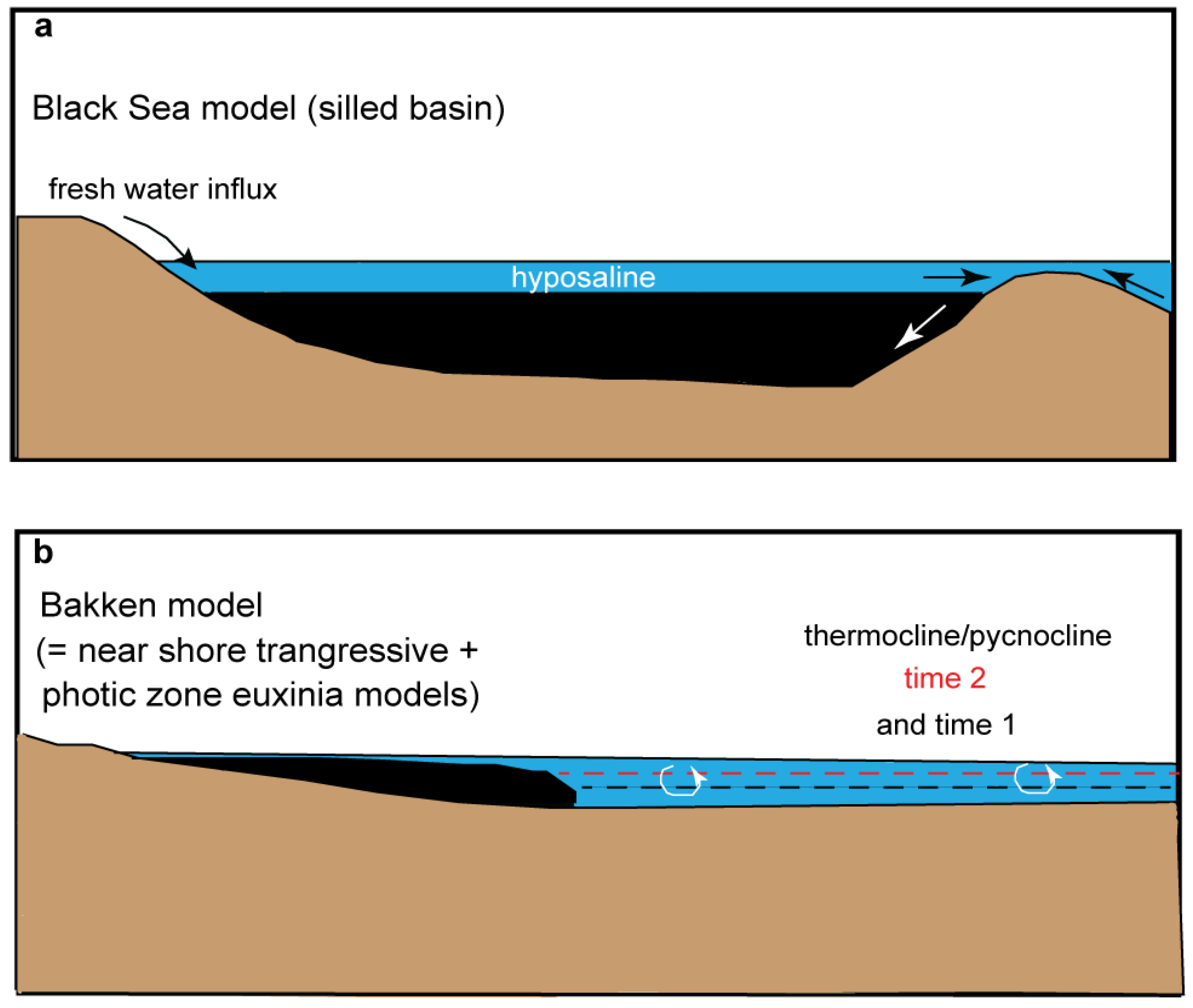
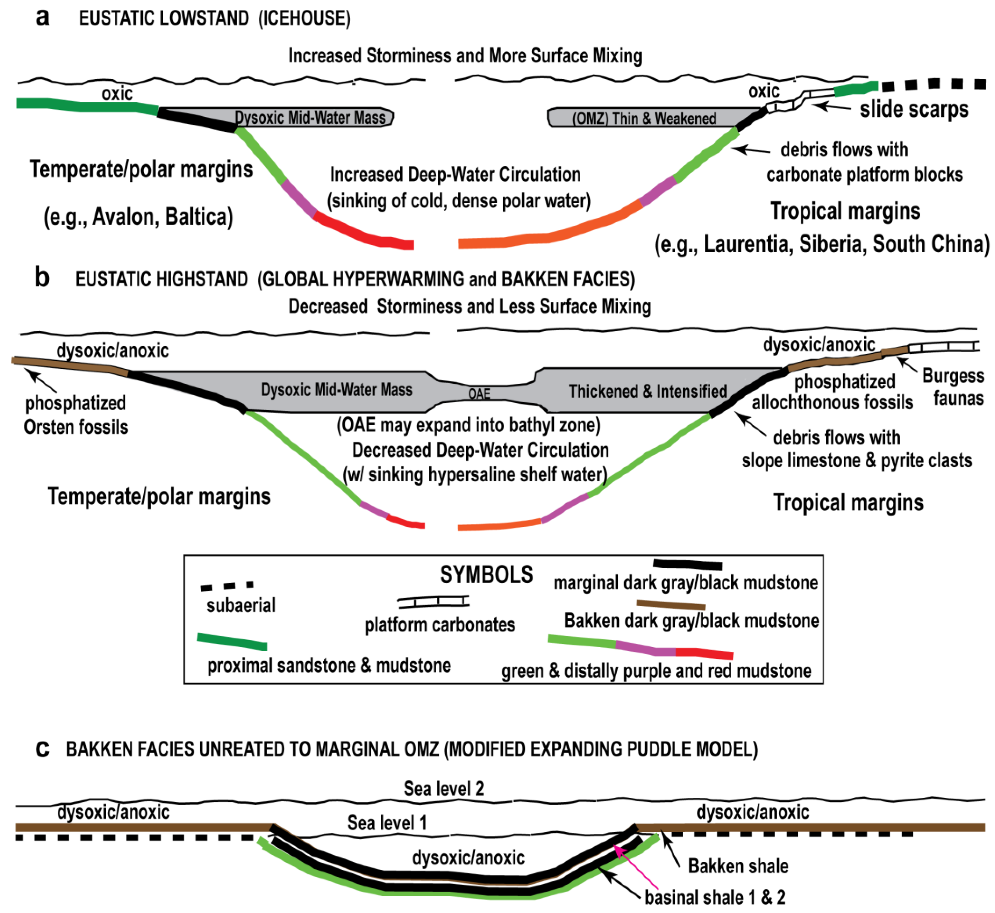
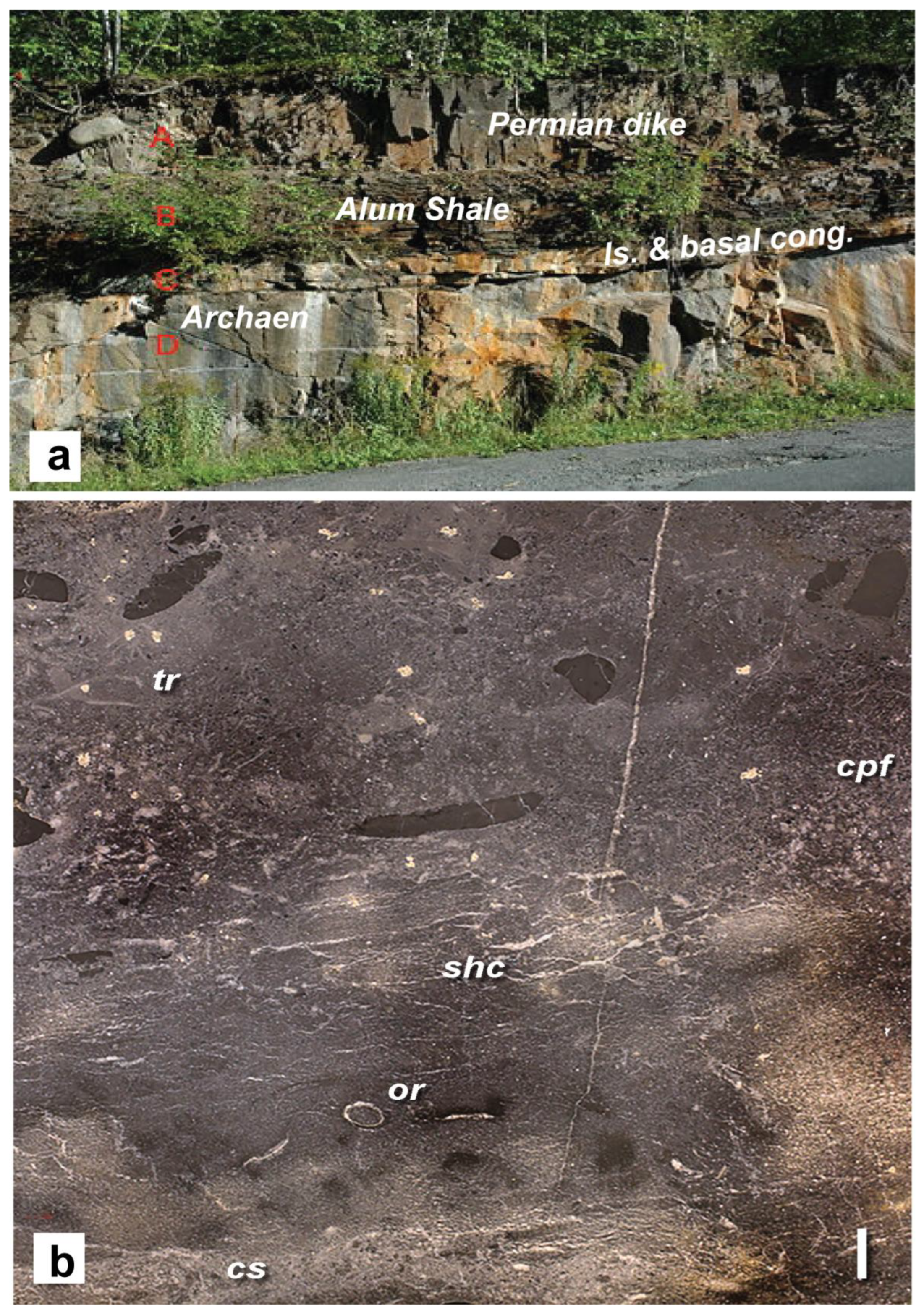
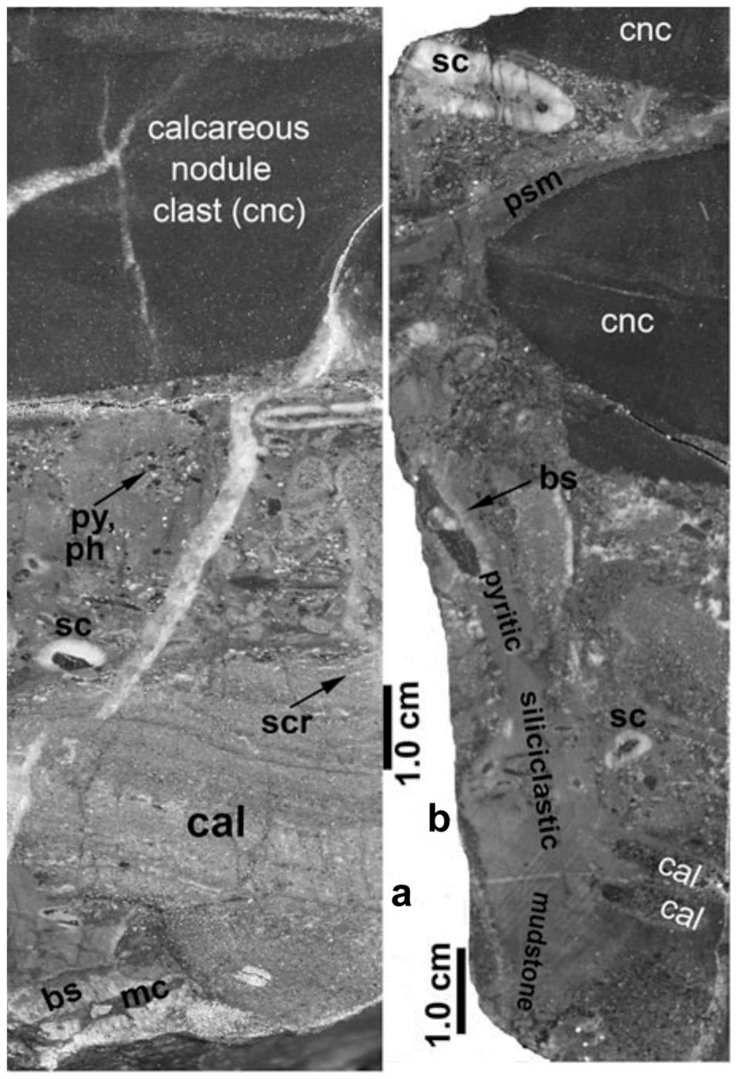

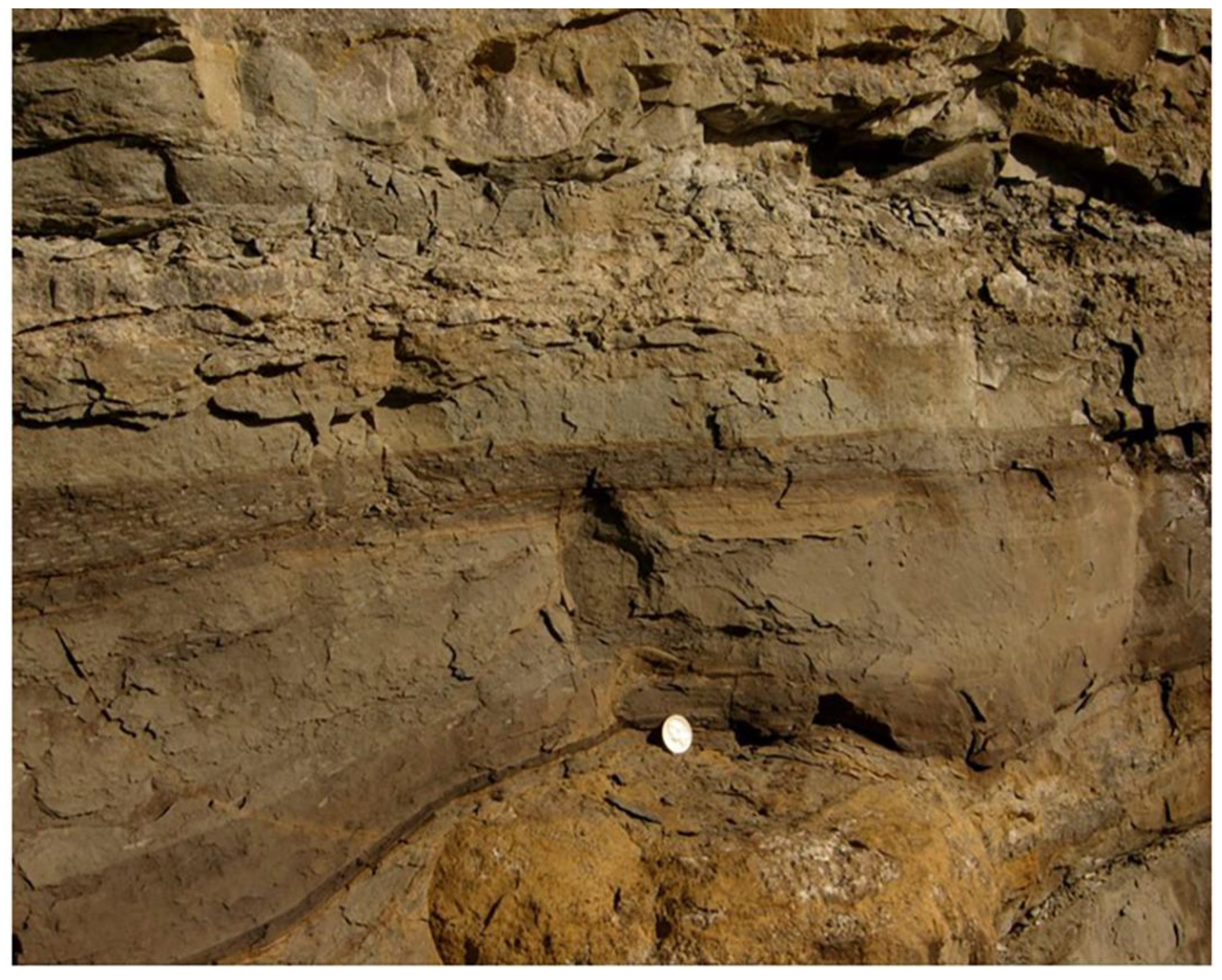
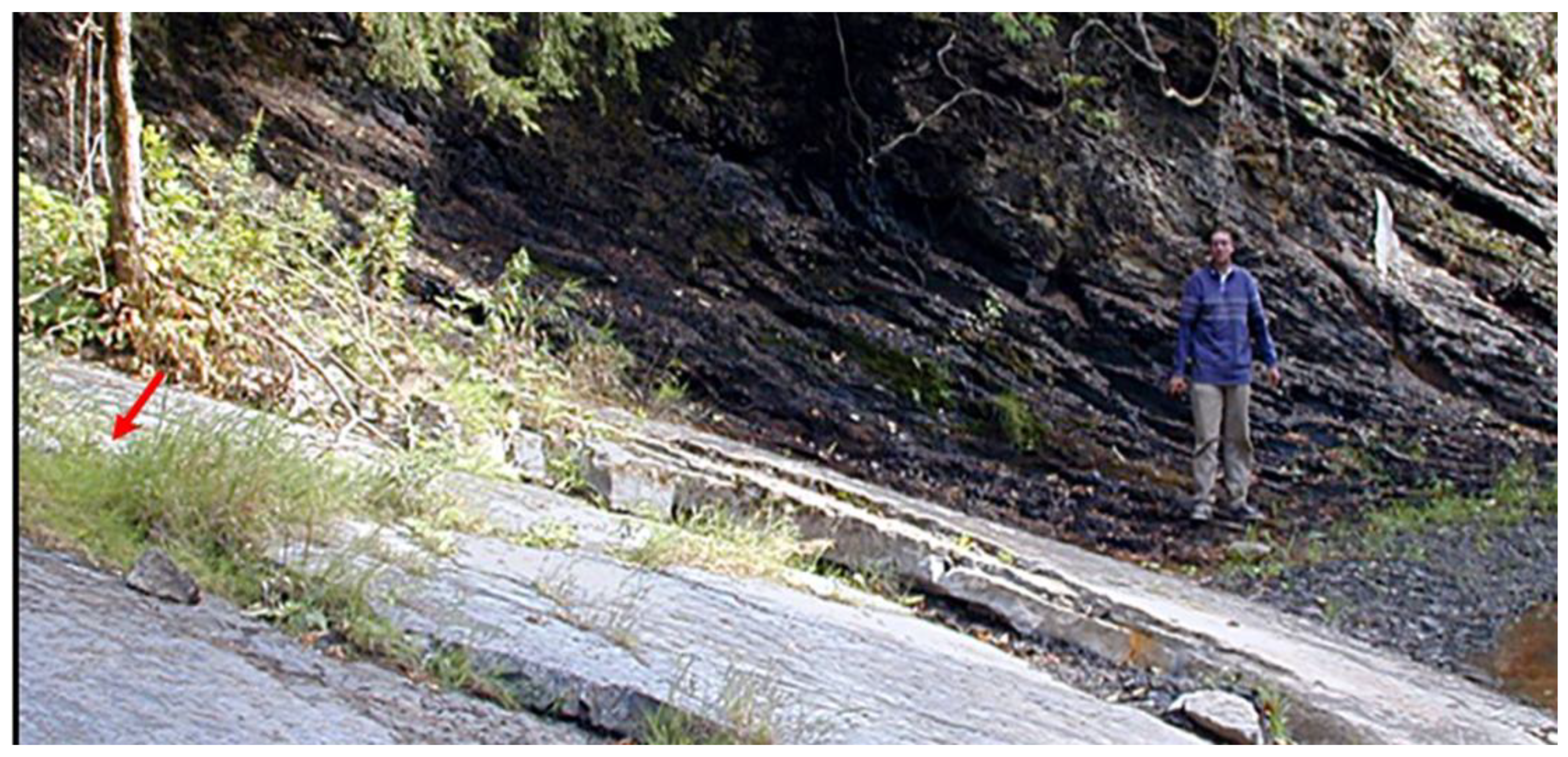

Disclaimer/Publisher’s Note: The statements, opinions and data contained in all publications are solely those of the individual author(s) and contributor(s) and not of MDPI and/or the editor(s). MDPI and/or the editor(s) disclaim responsibility for any injury to people or property resulting from any ideas, methods, instructions or products referred to in the content. |
© 2025 by the author. Licensee MDPI, Basel, Switzerland. This article is an open access article distributed under the terms and conditions of the Creative Commons Attribution (CC BY) license (https://creativecommons.org/licenses/by/4.0/).