1. Introduction
OWFs are among the most promising renewable energy technologies, particularly relevant to the maritime industry. Over the last two decades, they have evolved both in number and size. As the global shift towards a green economy accelerates, with a growing emphasis on efficiency, environmental protection, and sustainable energy, OWFs align very well with these goals. However, their progressive expansion in both number and scale introduces new challenges previously unaccounted for. At the same time, the ever-growing global maritime fleet is contributing to increasing congestion in many sea regions, especially in enclosed or semi-enclosed waters. The results of the latter are spatial and navigational conflicts as well as an increase in maritime traffic density and complexity. Therefore, these issues, in order to be solved, require coordinated efforts among all stakeholders, including international regulatory bodies, governments, maritime authorities, shipping companies, marine spatial planning (MSP) experts, and ocean engineers. Effective planning for OWF installations demands a holistic approach that incorporates collaboration across the maritime sector. All parties must recognize the broader implications and constraints of such infrastructure projects. Key factors to assess include the proposed location and size of the OWF, existing and projected maritime traffic density, meteorological conditions (e.g., wind speed and sea state), and any other elements affecting the safe operation of both the wind farm and surrounding navigable waters.
Any maritime sector stakeholder that represents an international or local regulatory body, in the sense of making new laws in the maritime industry, must keep in mind that new regulations and laws must take into consideration the safe cooperation of all agents of the shipping industry and the prosperous cohabitation of the latter and the marine environment. This matter must be carried out in a manner that ensures the safety of human lives (i.e., safety of navigation) is the parameter that is maximized in the overall picture. A deep and analytical approach is mandatory to ensure the safe cohabitation of the existing maritime traffic and potential new marine infrastructure directly connected to it. Identifying the potential risks of OWF installation is the first step in the process. The Itoh [
1] study introduces a method with which to predict how new maritime traffic rules, like restrictions or offshore developments, will affect ship traffic and encounter frequency (EF). It uses a sensitivity analysis to identify the key factors influencing EF, and models the future traffic behavior under temporal restrictions. The method accurately forecasts where and how often ship encounters may occur. These insights support safer maritime planning when introducing new regulations or offshore structures.
This literature review article gives an extensive overview of the scientific papers, research, and other relevant work related to OWFs and the safety of navigation. The paper aims to cover every aspect of what a typical literature review paper includes. The purpose and goals of this literature review are polyvalent, and they can be summed up as follows:
Find out what information already exists in this specific field of research;
Identify major seminal works;
Identify gaps in the literature;
Find other scientists working in this field;
Identify main methodologies and research techniques;
Identify main ideas, conclusions, and theories, and establish similarities and differences;
Provide context for our research.
The idea behind this article was to identify the major risks posed by OWFs and their implications on the safety of navigation by reviewing as much relevant literature as possible, without narrowing the focus to something overly specific or broadening it to the point of losing relevance to the topic. The safety issues of OWF installation are ambiguous. The first issue lies within the question of the safety of navigation in the vicinity of the OWF, especially navigation in rough seas and heavy weather in the vicinity of the OWF. The second issue is related to the congestion of navigable space—meaning, when speaking of the theoretical installation of new-built OWFs, there will inevitably be an alteration in maritime traffic flow. The result of that is increased maritime traffic complexity. Additionally, when observing semi-enclosed seas, this effect becomes magnified. There are very few scientific papers addressing the second issue properly. This research can be useful for nautical engineers, ocean engineers, MSP experts, and any other researchers as a strong basis for further discoveries and analyses. Maritime industry stakeholders can also gain valuable insights from it. Lastly, this literature review and bibliometric analysis paper will be the integral part of a PhD thesis on the topic of the safety of navigation and the impact of OWFs on the ever-increasing maritime traffic complexity.
This article is divided into five sections:
Section 1 is introductory, and the goals and purpose of the research itself are stated here. The structure of a whole paper is given. Additionally, this section has two subsections giving a brief history and general classification of the OWFs, and a short overview of the maritime incidents involving OWFs, respectively. The main navigational safety concerns are identified.
Section 2 provides an explanation of the methodologies used to screen, gather, and analyze the scientific bibliography used in the making of this article. In this section, the authors describe the purpose behind using specific methodologies, in this case, Preferred Reporting Items for Systematic Reviews and Meta-Analyses (PRISMA) and Population, Intervention, Comparison, Outcome, Context (PICOC). The literature retrieval process is explained as well. Additionally, the scope of the research is defined, and the intel on dataset creation is presented, as well as data processing techniques and tools.
Section 3 is the core of this research. It gives detailed insights into the most relevant bibliometric analysis parameters, such as categorizing scientific papers by countries, authors, number of authors per paper, frequency and connection of keywords, types of papers, source of paper, distribution of papers per the most relevant journals, annual publication count, etc. In
Section 4, the discussion of the key findings is presented together with the analysis results. Further work suggestions and further research directions are commented on briefly in this section. Finally,
Section 5 summarizes all the key factors, and the research findings are consolidated.
1.1. General Classification and History of OWFs
Offshore wind power (OWP) or offshore wind energy (OWE) is the generation of electricity through wind farms in bodies of water, usually at sea. There are higher wind speeds offshore than on land, so OWFs generate more electricity per unit of capacity installed. Additionally, OWFs are also less controversial than those on land, as they have less impact on people and the landscape [
2]. The reason behind OWP having a much better potential than the classical onshore wind power lies within geography and meteorology. The nature of the wind at sea is somewhat different from that on land. Multiple factors lead to this conclusion. First, offshore wind has generally higher speeds than onshore wind; secondly, it blows with greater consistency; and finally, there are no topographical obstructions on the sea as on land (i.e., hills, mountains, human structures, etc.) to act as a physical interference.
OWE has undergone remarkable development since it began in the early 1990s. The first OWF in the world, Vindeby, was built in 1991 off the coast of Denmark. It consisted of 11 turbines with a total capacity of 5 megawatts (MW) and served as a groundbreaking demonstration of wind energy’s viability in marine environments. Inspired by Vindeby’s success, the United Kingdom launched its first OWF near Blyth in 2003, which, at the time, was the largest globally. This period marked the start of the rapid growth in offshore wind across Europe, fueled by technological innovation and the increasing investment in renewable energy [
3]. The United States joined the offshore wind sector in 2016 with the commissioning of the Block Island Wind Farm in Rhode Island. This project included five turbines, accounting for a combined 30 MW, marking the country’s entry into OWE production [
4]. A major breakthrough in the industry has been the development of floating OWFs, which allow for wind energy generation in deeper waters where fixed-bottom turbines are not viable. The concept was originally proposed in 1972 by Professor William E. Heronemus [
5]. One prominent example is the Kincardine project off the coast of Aberdeen, Scotland, which deployed some of the largest floating turbines of its time, capable of supplying power to around 35,000 homes [
6]. As of 2025, OWE continues to grow rapidly, with major projects underway across Europe, North America, and Asia, playing a crucial role in the global shift toward sustainable energy.
One of the first studies including OWFs and the safety of navigation was conducted by Christensen and Andersen in Denmark in 2001. The study takes a closer look at the risks of ships colliding with OWFs, specifically focusing on a project located at Rødsand, south of Lolland in Denmark. It covers the setup of the wind farm, including the layout of the wind turbines and the size of the area, and highlights the importance of protecting key parts like the trafo module from ship collisions to avoid power outages [
7].
Offshore wind turbines (OWTs) are generally categorized into two main types: fixed-bottom and floating. Each of these categories includes several subtypes. The specific technical characteristics of these turbines depend largely on the water depth at the installation site. Fixed OWTs are typically installed in water depths ranging from 15 to 60 m, with the most common installation depth falling between 30 and 50 m. In locations with strong wind resources but deeper waters, beyond 60 m, floating OWTs become necessary. Unlike fixed turbines, floating OWTs are anchored to the seabed using mooring lines rather than fixed foundations, which means they are not subject to strict depth limitations. However, practical and economic constraints play a significant role. Most floating OWTs are currently deployed in depths between 100 and 700 m, though some projects have explored installations as deep as 1000 m. While deeper waters pose greater challenges in terms of mooring, cable management, and maintenance, ongoing technological advancements may eventually enable deployment in even more extreme environments. The Biehl and Lehmann [
8] study evaluates the collision safety of various OWF foundations, highlighting that monopiles are inherently collision-resistant, whereas jackets and tripods need further design improvements. Numerical crash tests show how impact energy is absorbed or transferred, influencing the structural integrity and environmental risks. The Wawruch and Stupak, and Moulas et al. [
9,
10] studies use an advanced finite element analysis and international models for estimating collision probabilities and examining ship collisions during the construction and operation of the OWF. They assess the damage from vessel impacts on two types of turbine foundations (monopile and jacket). Simulations of 44 collision scenarios show that the damage depends on the vessel type, speed, and impact angle, mainly causing plastic deformation without structural collapse. Key areas like X-joints are most vulnerable. Findings stress the need for an improved design and damage assessment to enhance OWF safety. The Sen and Song [
11] study focused on structural impact analysis.
1.2. Safety of Navigation near OWFs and Maritime Incidents Including OWFs
The avoidance of collisions with obstacles is a key component of safe navigation [
12]. Moreover, the safety of navigation in the vicinity of OWFs is a critical concern for maritime operations because it requires the careful consideration of vessel traffic, navigational aids, and regulatory frameworks. As mentioned before, OWFs introduce navigational hazards such as restricted maneuvering areas, potential interference with radar and communications systems, and risks of allision (meaning collision between a stationary object and a vessel underway). One of the most interesting and least examined potential problems regarding OWFs is their impact on maritime traffic complexity. Having a large-scale OWF, especially in a semi-enclosed sea, means an inevitable impact on the increase in maritime traffic complexity [
13,
14].
Incidents involving OWFs and ships that navigate around them have occurred on occasion; yet, serious accidents are relatively rare. One such event took place in 2019 when a Dutch fishing vessel accidentally hooked an underwater cable, leading to a temporary disruption in the power supply. In 2022, a cargo ship struck a turbine at the Horns Rev 2 wind farm off the Danish coast, causing structural damage but no injuries. A year later, a Chinese bulk carrier collided with a transformer platform at a German offshore site, highlighting the ongoing concerns about navigational hazards in these areas.
In a notable maritime incident, a vessel collided twice with the same OWT due to navigational errors. The incident occurred during heavy weather conditions. The vessel was in dynamic positioning (DP) mode when it decided to pull off. While moving away, the vessel first made an allision with the turbine. Subsequently, a second allision occurred as the vessel attempted to maneuver away from the structure. Investigations revealed that the crew’s misjudgment and inadequate situational awareness contributed to the accidents. The report emphasized the need for improved training and the adherence to safety protocols to prevent similar incidents in the future [
15].
On 19 February 2019, the wind farm service vessel World Bora, operated by World Marine Offshore, collided with the 81 m cargo ship MV Raba off the coast of Rügen, Germany, while supporting operations at the Wikinger OWF in the Baltic Sea. At the time of the incident, World Bora was carrying 15 individuals: 4 crew members and 11 technicians (9 from Siemens Gamesa and 2 from Iberdrola). The collision resulted in injuries to 11 people, all of whom were hospitalized; fortunately, none of the injuries were life-threatening. The World Bora sustained significant damage to its port bow, including a torn fender and bent railings. Investigations by the Federal Bureau of Maritime Casualty Investigation and the Danish Maritime Accident Investigation Board revealed that the collision occurred at high speed—World Bora was traveling at approximately 18 knots—and that visibility was poor due to slight rain and low light conditions. Notably, this was the second incident involving World Bora; in August 2018, a fire broke out in its engine room while servicing the same wind farm [
16].
In April 2023, the general cargo ship Petra L collided with a wind turbine at the Gode Wind OWF in the North Sea, off the German coast. The vessel sustained serious damage, including a hole measuring approximately 3 by 5 m on its starboard hull. Despite the significant breach, the crew managed to abandon the damaged ship safely to the port of Emden, and no injuries were reported. Initial investigations suggested the ship had veered miles off its intended course, potentially due to an autopilot malfunction. Authorities criticized the ship’s captain for failing to report the incident in a timely manner, and legal proceedings were initiated [
17].
On 21 April 2025, a vessel operated by Glomar Offshore collided with an OWT, resulting in injuries to two crew members. The incident occurred during operations at a wind farm, and the Royal Netherlands Sea Rescue Institution (KNRM) responded promptly to assist. Both injured individuals were transported to a hospital for treatment; fortunately, their injuries were not life-threatening. An investigation is underway to determine the cause of the collision [
18].
Near-miss situations have also been documented, particularly in heavily trafficked regions such as the North Sea, where wind farms are located near major shipping corridors. Some incidents have involved fishing boats unintentionally breaching restricted zones and damaging subsea equipment. Rough sea conditions have contributed to collisions as well, including those involving maintenance vessels and turbine structures. Military activity has not been without risk either; a British naval ship reportedly ventured too close to a wind farm during a training mission. To reduce such risks, many offshore installations now employ technologies like radar monitoring, an automatic identification system (AIS), and clearly marked exclusion zones. However, as the offshore wind sector continues to grow, so do concerns about maintaining a safe coexistence with maritime traffic [
19].
There are already a decent number of so called “OWFs hotspots”, areas at sea where there is a higher concentration of OWFs in close proximity with the navigational routes. The most popular of such areas are as follows:
Europe—Southern North Sea and English Channel—A cluster of OWFs, such as Dogger Bank, Hornsea, and Thanet lie directly within busy shipping lanes through the Dover Strait and the southern North Sea, one of the world’s busiest maritime corridors;
UK—Thames/Medway Estuary—Numerous OWFs can be found near the Thames Estuary edge into the main southbound UK shipping lane. Adjustments to the navigational routes are routinely made;
Baltic Sea—The Middelgrunden and Lillgrund OWFs sit just 3.5 km and 10 km from the narrow Øresund shipping channel into the Port of Copenhagen, with heavy traffic enjoying very close proximity to turbines), and Kriegers Flak, which forms the part of a cross-border grid between Denmark and Germany, sits near major Baltic shipping paths, with vessels passing within 10 km;
Asia—East China Sea—Yangtze River Estuary: Multiple OWFs are proposed just north of the estuary inside the Maritime Silk Road. This is among China’s busiest commercial routes, with container ships, tankers, and bulkers concentrated in narrow lanes.
According to Marine Guidance Note 654 (MGN 654) issued by the UK Maritime and Coastguard Agency (MCA), the minimum recommended passing distance for ships including merchant vessels when transiting near an OWF is 1 nautical mile (NM) from the outermost turbines. This distance provides a safe buffer from the array boundary. To give the full context, MGN 654 recognizes that ships frequently pass as close as 1 NM from established turbine arrays, and this is considered “safe and reasonable” based on historical data. When setting up a navigation corridor through or near an OWF, MCA guidance typically applies a 1 NM offset from the array, plus additional width to accommodate vessel maneuvers such as overtaking and turning. Thus, in practical terms for maritime merchant fleets, maintaining at least 1 NM from any OWF array is the established minimum, with captains free to choose greater distances based on sea conditions, cargo type, and other navigational considerations [
20].
2. Materials and Methods
In the writing process of this article on the safety of navigation threats posed by OWFs, it was noticed that there is a considerable number of various methodologies when conducting the literature review and bibliometric analysis. Therefore, it was of great importance that any methodology chosen provided satisfactory results in terms of covering all the literature and meeting the criteria of a comprehensive literature review. One of the most common methodologies when writing a literature review is a systematic literature review (SLR), PRISMA, and PICOC. Having looked deeper into the structure of each methodology, i.e., purposes and goals, it was decided that we would stick to the hybrid method of PRISMA and PICOC for this literature review. Additionally, the fact that a decent number of researchers in the field of maritime studies have chosen the same methodologies adds credibility to the decision of this choice [
21,
22,
23,
24,
25,
26,
27].
The combination of the PRISMA and PICOC methods enables the formalization of the high-quality standards of the literature review. By using both methods, we wanted to cover all the relevant research in the field of OWF and the safety of navigation, and have a fully systematic and comprehensive literature review, which acts as a base for a further detailed bibliometric analysis.
2.1. Literature Review Methodology
The PICOC method is essential for formulating the research question and filtering out relevant literature sources through five key components:
(P)opulation refers to all types of scientific papers such as PhD and MSc dissertations, journal articles, conference proceedings, web studies, independent research, etc., in the field of the safety of navigation and risk assessment of OWFs.
(I)ntervention focuses on the application of different methodologies and research tools and techniques, such as AIS data analysis, Fuzzy Logic (FL), and Kernel density estimation (KDE), mathematical modelling and simulations, i.e., Monte Carlo simulations (MCS), etc., in analyzing the safety of navigation near OWFs, and subsequent changes in maritime traffic complexity.
(C)omparison analyzes different approaches to the application of the mentioned methodologies in the field of the safety of navigation and changes in maritime traffic complexity near OWFs and compares them.
(O)utcome identifies and evaluates the risks of OWF installation and the improvement of existing methods and models in the context of the safety of navigation and risk assessment of the maritime traffic in the area of OWFs.
(C)ontext refers to the application of these methods in the field of maritime safety risks, with a particular focus on the safety of navigation and risk assessment implementation of the relevant technologies [
22,
23].
The PRISMA method provides a standardized framework for conducting and reporting systematic literature reviews. It emphasizes transparency and reproducibility by guiding researchers through a structured process that includes the identification, screening, eligibility, and inclusion of studies. In
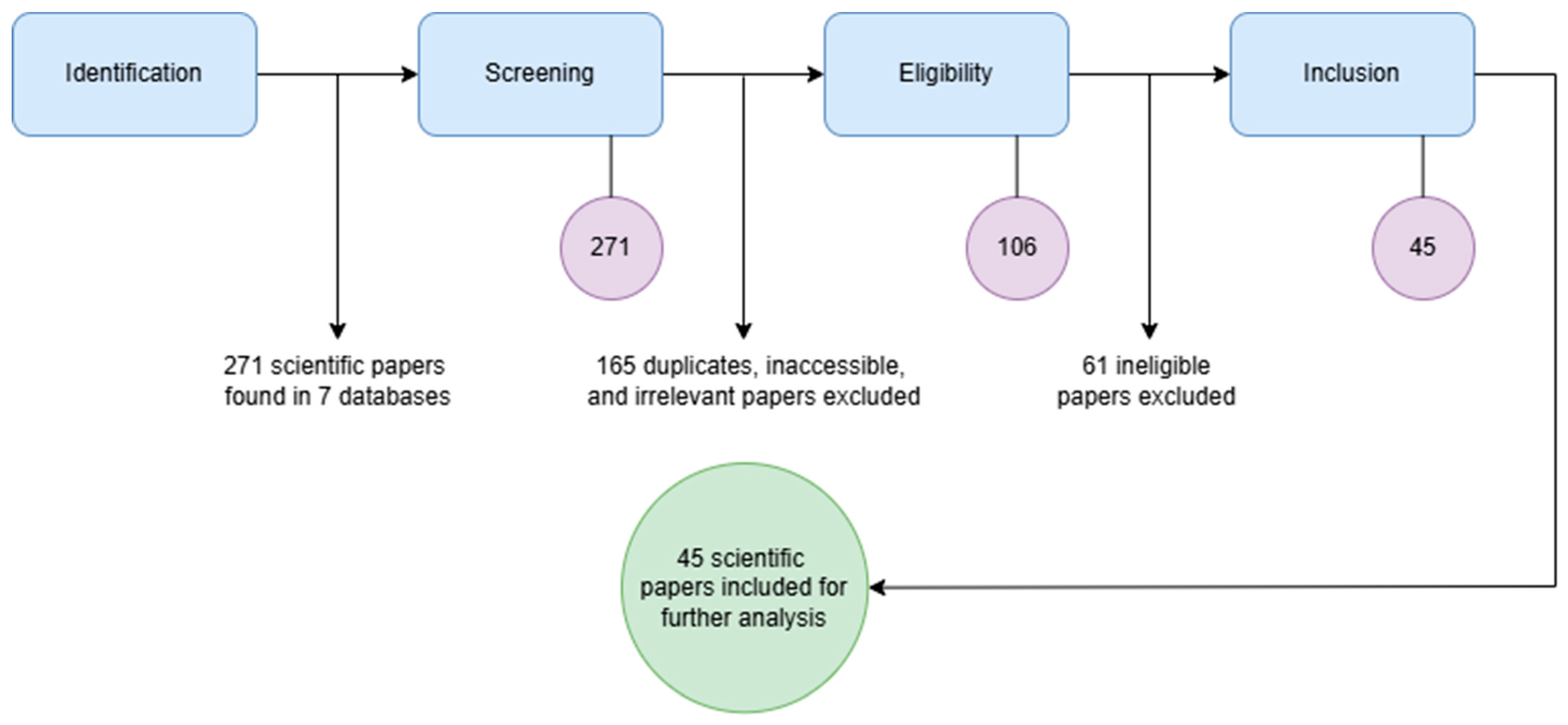
Figure 1 below, the literature retrieval process, following the PRISMA guidelines, is shown.
Steps in the literature retrieval process according to PRISMA guidelines are as follows:
Step 1: Identification of scientific papers relevant to our study. The literature search began by deciding what keywords were going to be used in a scientific database search engine to scrape the relevant literature in the field of OWFs and safety of navigation. After careful consideration of the scope of the study, we decided to use the keywords “
offshore wind farms”, “
safety of navigation”, “
ship collision”, and “
risk assessment”. The visualization of the latter can be seen in
Figure 2 below.
Step 2: Screening the identified papers. The purpose of screening the articles was to identify those relevant to our study through a comprehensive search, while excluding those that did not align with the research’s main focus. Screening involved reviewing the titles, abstracts, and conclusions, as well as skimming the main content of each article. A full review was conducted only if the article addressed the OWFs and safety of navigation (this will be explained more thoroughly later in the article). The retention rate was 128/271 or approximately 47%. During this phase, duplicate articles were removed, and several potentially relevant but inaccessible studies had to be excluded from the analysis.
Step 3: Eligibility assessment of the screened papers. This step is where the acceptance of the scientific papers is conducted. All of the papers from the previous step were thoroughly analyzed, and only the most important ones were selected for further analysis. The retention rate in this step was 74/128 or approximately 58%. Little over half of the screened papers were processed further to ensure a broad perspective in the research field, to make sufficient material for conducting a bibliometric analysis.
Step 4: Analysis of the final included papers. By this step, the literature retrieval process was finished, and the basis for a comprehensive bibliometric analysis was formed. Only the papers that came to this phase were taken into consideration for the creation of the bibliometric analysis dataset. These scientific papers were read thoroughly in their full text, taking into consideration all the insights, information, and implications from every single paper to make sure that the further analysis can be adequately conducted [
21,
24,
25,
26,
27].
Figure 2 shows a Venn diagram where the circles represent the keywords used in the literature scraping process. It also shows the area of the original scope of this study. In the first literature scraping iteration, the only papers that were taken into consideration lay within this rather narrow area of interest. The area of intersection of all four keywords is what is called “the core area of interest of the study”. Using this approach, it was very quickly found out that this area is too narrow to have an adequate number of studies to make a valid, comprehensive literature review and bibliometric analysis. This approach gave us only 13 scientific papers. Therefore, we needed to expand the scope of our own research. This was carried out by broadening the scope of the research by doing the following: All the scientific papers that were going to be identified and taken into the screening process should have an overlap of at least two keywords, of which one has to be “
offshore wind farms”. By doing so, we managed to expand the number of scientific papers to a substantially larger extent, 271 scientific papers to be exact.
For the purpose of this literature review, 7 scientific databases and web pages with scientific papers listed were searched.
Table 1 shows which of the scientific databases and web pages were involved in the literature scraping process.
Table 1 below shows all the searched databases and scholarly search engines used in this study, and the distribution of the number of mentioned papers per each database.
Even though Google Scholar, Dimensions.ai, and ResearchGate are not scientific databases, they represent relevant web search engines that specifically search scholarly and academic resources. Therefore, we decided to include them as a search tool in the literature scraping process. From
Table 1, it can be seen that the majority of the literature that was included in the dataset for bibliometric analysis, 33 or 73% to be exact, came from WoS and Scopus databases, as well as the Google Scholar scholarly search engine. It is important to notice here that, even though it was expected that the WoS database has the highest number of research studies, Google Scholar turned up more results (in the form of scientific papers) which are indexed in WoS, but, during the first iteration of the literature search, did not show up in WoS. It is believed that this is a technical issue or just a mere perspective of the authors. Because of this exact reason, as the authors of this study, we decided to categorize these papers into Google Scholar numbers rather than WoS numbers. The same happened to the Scopus database, but to a lesser extent.
2.2. Bibliometric Analysis Description
The creation of the dataset is the most important factor before conducting a comprehensive bibliometric analysis. In this case, data is represented by all the scientific papers, research studies, and other relevant papers in the field of safety of navigation and OWFs. The dataset of this research comprises 74 sources saved in an Excel spreadsheet. The spreadsheet contains all the scientific papers relevant to the field of safety of navigation, ship collision, and risk assessment connected to OWFs. The spreadsheet is sorted chronologically, by the year of publication for each paper.
Table 2 below shows the connection between the serial number of a column and the item that it represents. The more detailed explanation is given as follows: Column 1—Paper ID. An aid for classification of data for authors; Column 2—Title of paper. The title of each paper, as seen in the database; Column 3—Keywords. All of the keywords are listed regardless of their number; Column 4—Authors. List of authors by the name appearance; Column 5—Number of authors. Total number of authors on publication, in this case, it varies from 1 to 7; Column 6—Type of paper. Predefined list that consists of 4 options as follows: “Journal article”, “Conference proceeding”, “PhD dissertation”, and “MSc thesis”; Column 7—Source of paper. This can be the name of the scientific journal that published the paper, or the name of the conference that published it in their book of proceedings. In case of PhD dissertation and MSC thesis, the source of the paper is the name of the institution where the dissertation or thesis is defended; Column 8—Year of publishing. This is the year when the publication was official; Column 9—Country of origin. Unlike other items, this item is not self-explanatory, so it needs further clarification. Categorization of scientific papers by the country was done by looking into the country of origin of all the authors of the paper; i.e., if the paper has four authors that all come from four different countries, then all four countries would get an endorsement for it in this column; Columns 10–16—Indexing data for the database. These columns indicate where the paper has appeared, and they are of Boolean type, meaning they take values of only 0 s or 1 s. As already mentioned, there are seven different scientific databases and scholarly search engines, WoS, Scopus, ScienceDirect, IEEE Xplore, Google Scholar, Dimensions.ai, and ResearchGate, with their columns, respectively. For example, if a certain paper appeared in the Scopus database, it would mean that, in that row, Column 11 would have the value of 1 and the rest of the columns would have the value of 0, consequently.
This type of data structuralization enables the basis for further analysis and assures the meeting of the PICOC methodology criteria. All data analysis and data visualization were carried out using a combination of Microsoft Excel (version 2019) and Microsoft Power BI (version 2025) —a data manipulation, visualization, and reporting platform. This software gives a very detailed granulation of data and appropriately facilitates data visualization. It also has an option for importing data from an Excel spreadsheet, which was very useful in this case [
28,
29].
3. Results
A comprehensive bibliometric analysis implies the categorization of bibliometric data by leading authors on the chosen topic, collaboration between the leading authors, number of authors per paper, leading countries (number of publications per country), publications per year, sorting the types of bibliometric data, most frequent intertwined keywords, and distribution of scientific articles across the journals.
Figure 3 gives a visualization of an interweaving of the term “
offshore wind farms” with the most used keywords in the Scopus database. This visualization is presented by a distance-based map, and it was created by an online data visualization tool called VOSviewer (version 1.6.20), which is a software tool designed for constructing and visualizing bibliometric networks.
The visualization in
Figure 3 shows the clusters of fields of interest around OWFs. It can be seen that the terms that are linked to the term OWFs are “navigation safety” and “marine navigation,” implying the close relation between the two. Other keywords such as “risk assessment”, “risk analysis”, and “risk factors” are very high in the number of correlations with the OWFs, triggering the assumption that a decent amount of research is risk-modelling-oriented. The color gradient shows the progress of research trends from 2000 to 2025, reflecting the interdisciplinary and dynamic nature of studies to improve the safety of navigation in the vicinity of OWFs.
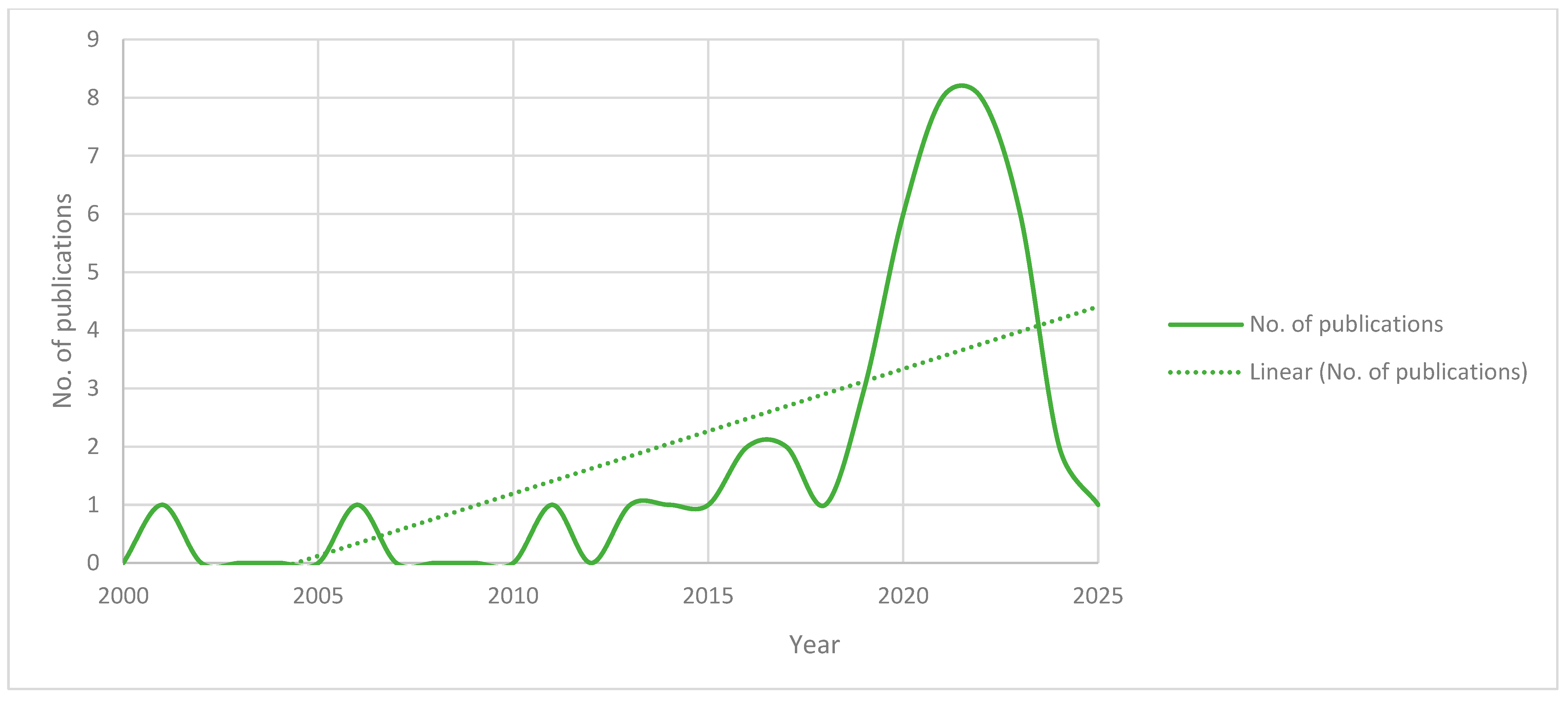
Looking at
Figure 4, it can be seen that, since 2015, there has been a significant increase in the number of publications related to OWFs and the safety of navigation. It is believed that this trend is closely related to the fact that, in the last 10 years, the world economy has significantly turned to a greener environment with an emphasis on renewable sources of energy. Because of this rise in OWF numbers, there is also a greater need for scientific research in this field. These results show that OWFs are somewhat what is often called a “hot topic” in science. The research trend seems to be inevitable, indicating that this would be the best time to delve into this field of interest with scientific research work.
In the last 5 years, from the year 2020 until the end of the year 2024, there have been 30 scientific papers related to OWFs and the safety of navigation. The years 2021 and 2022 were the years identified as periods with the highest publication activity. This indicates that, as time goes by, there are progressively more and more scientific papers on this topic. As a disclaimer, contrary to the common opinion, the year 2025 had only one publication on the topic because it was just the beginning of the year (February, to be exact) when the dataset was formed. As far as the paper and data representativeness are concerned, it is important to notice the following: since the publication number is relatively small, we recognize that the findings presented in this study are subject to the limitations of our dataset, which may not fully capture the entirety of the existing research on OWFs. While we strived for comprehensive coverage, the representativeness of the data is inherently influenced by the selection criteria and availability of sources. Readers should interpret the trends and conclusions only within this context.
In
Figure 5, a visualized distribution of scientific papers per country is presented. As expected, China is the greatest contributor worldwide. There are multiple reasons for this: China is the most populated country in the world and the country with the highest number of scientists. Another reason is that China has a rather long shoreline and a very good geostrategic potential for the installation of OWFs. Poland was somewhat of a surprise, taking second place after China, having more scientific papers published than the USA, South Korea, and the UK. European coastal countries like Sweden and Germany have at least two contributions. Nevertheless, a large proportion of the contributions to this field of research come from Asian coastal countries such as South Korea, Taiwan, and Japan. Other European countries each have a single contribution. Other countries that also contributed to the research can be seen in
Figure 5 below. Looking at the number of publications per country data, it can be concluded that, in most of the countries with maritime exploration research, the topic of OWFs and the safety of navigation is currently an interesting and useful topic.
Figure 6 gives a visualization of the number of various scientific papers published across different sources. The sources are as follows: scientific journals, conference proceedings, databases from universities (in the case of PhD dissertations and MSc theses), and web sources that publish scientific research on a regular basis. It is presented in the form of a radar chart because of its convenience.
During the writing of this literature review, the authors identified various scientific journals containing articles on the topic of OWFs and the safety of navigation. The leading journals in this field are the Journal of Marine Science and Engineering (JMSE), Ocean Engineering, Reliability Engineering and System Safety, TransNav, Journal of Navigation, and IEEE Access. Furthermore, the first two, JMSE and Ocean Engineering, contain more than 22% of the publications in the dataset. Both are indexed, according to Journal Citations Report (JCR), as Q1 or Q2, which represents scientific journals with a high impact and quality. It can be concluded that these two are journals of choice for the authors and researchers in this field of interest, and they represent the essential and most relevant journals. As for the international science conferences, there are more than nine different ones, mainly in the field of maritime transportation safety, offshore mechanical engineering, and environmental sciences. Interestingly, the annual International Conference on Transportation Information and Safety (ICTIS) had more than one contribution, but in different annual installments. Other than this, it was not noticed that any of the annual recurring conferences have significantly more publications than others.
Figure 7 gives insights into the type of published papers on the topic of OWFs and the safety of navigation. The types of papers covered are as follows: journal articles, conference proceedings (or conference papers), Master’s degree theses (MSc theses), and Doctor of Science (PhD) dissertations.
It can be seen that journal articles play a major part in this classification, giving this topic added credibility. Almost 70% of the publications in the dataset are of the journal article type. It is important to mention that most comprehensive scientific research and papers that are most relevant in a given field are almost always journal articles. MSc theses and, especially, PhD dissertations are the most complex and scientifically contributed research works, and but they are rare (because of their rather extensive volume) and can never be compared to journal articles by their numbers. Conference papers also play a major role in this classification, having 22% of the stake by volume. To conclude, major seminal works in this field are published in major scientific journals or as an MSc thesis or a PhD dissertation.
During the literature search process, the authors detected major scientists in the field of OWFs and their impact on maritime safety.
Figure 8 represents a bar chart with the number of publications by individual scientists and researchers who have at least two publications in the dataset. The two most promising and most active scientists are Q. Yu and K. Liu, with six publications each. It can also be noticed that R. Ali Mehdi is one of the major contributors to this field because of his PhD dissertation and multiple journal articles. Insights from this classification can be of crucial importance to further research in this field. Other top contributing authors are listed in
Figure 8 below.
By knowing which authors are top contributors in the field, you can easily cherry-pick them during a literature search by the “search by name” option in the scientific database search engines. This process or technique saves a decent amount of time during the literature review, and it was used during the work on this article as well.
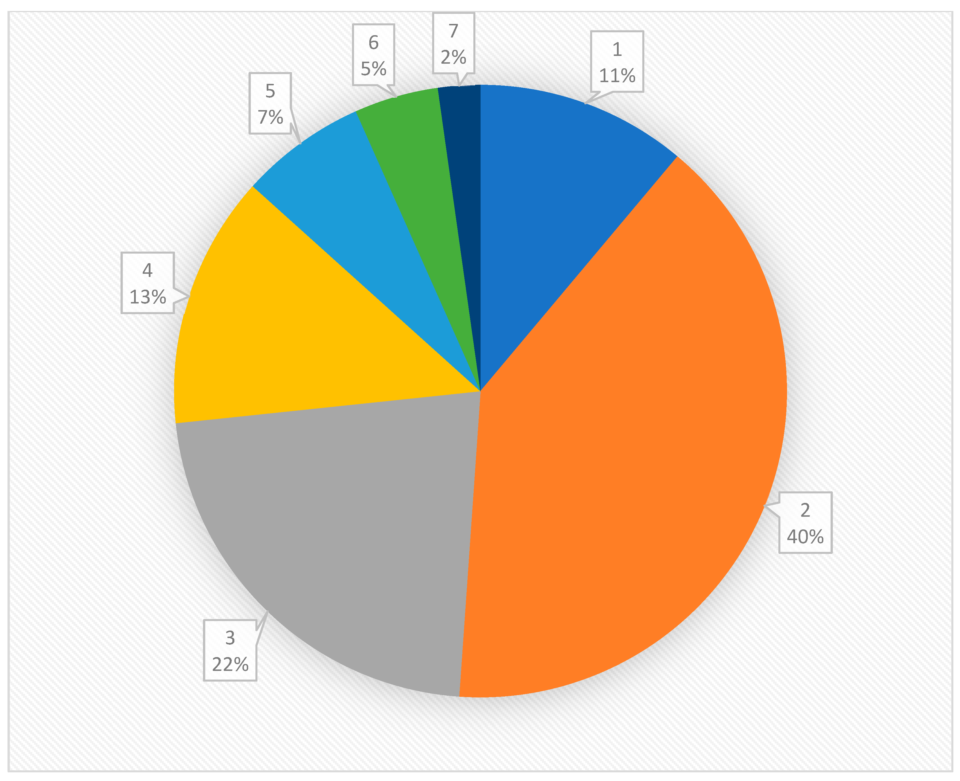
From
Figure 9, it can be concluded that most of the research in the field of OWFs and the safety of navigation tends to be collaborative works, meaning the research groups include two or more scientists. In
Figure 9, the number in the data label shows the number of authors per publication, and the percentage (and colored area in the pie chart) shows the frequency of publications for that number of authors. We see that the most common type of group is the group with two or three scientists, indicating that the smaller research groups predominantly conduct research in this field.
Even though larger research groups (5+ authors) are uncommon in this field, there is still a significant percentage of single-author papers, but the reason behind this result lies within the fact that MSc theses and PhD dissertations can only have one author.
Lastly,
Figure 10 represents clusters of the author collaboration network. This chart was made by VOSviewer using our literature dataset in an Excel spreadsheet as a base. It comprises 37 distinct clusters in which nodes (or dots) represent individual authors and curved lines connecting the nodes represent co-authorship relationships. The clusters are visually distinguished by various colors, showing the research groups with stronger collaboration. It can still be seen that Q. Yu and K. Liu are leading researchers and that they have made a major network around themselves in this field. In this visualization, they are represented by the biggest nodes on the chart. This analysis provides key insights into collaboration patterns and emphasizes leading contributors in the scientific community.
4. Discussion
It has already been mentioned that this field of research is believed to be a “hot topic” in ocean engineering, according to the timeline of publications. Moreover, during the writing of this literature review, having thoughtfully studied other literature review articles in the marine science and engineering field available online or similar research, it was realized that most of the literature reviews in the ocean engineering category, which use datasets in the form of scientific papers, almost always have a much higher number of sources in the dataset, typically 75–100. Consequently, the logical question was whether the literature revision process was conducted thoroughly enough. It is believed that the topic of OWFs in the sense of the threat to the safety of navigation has not been researched enough; therefore, there are simply not as many scientific papers dealing with this matter. This fact encouraged us even more to continue the research in this specific direction.
All the data manipulation, visualization, and analysis in this paper were carried out using a combination of online software tools specialized in that field. Excel was used as a database for storing data in the form of a spreadsheet. Power BI and default Excel charts were used to sort and create a sorted database and visualize the collected data in the form of various charts. Lastly, VOSviewer software was used to create a cluster visualization of the author collaboration network and the interweaving of the most important keywords visuals.
This literature review and bibliometric analysis article aimed to give a comprehensive quantitative analysis of scientific work related to OWFs and the safety of navigation. This article identified the top contributing authors, the number of publications per year, leading countries, most relevant scientific journals, and institutions. It detected the most relevant study groups or research networks and keywords used in scientific papers. It also examined the methodologies, research techniques, and tools used by scientists using the guidelines of the PRISMA and PICOC methodologies. It can be concluded that research in this field tends to be carried out by smaller research groups. The leading country is China, undoubtedly, with its vast number of scientists and geographical potential for offshore wind in general. The top contributing scientists are Chinese as well. There are progressively more publications per year, and this increase is magnified as of 2020, making the topic very relevant now. Scientific work related to the topic tends to be published in renowned scientific journals such as Ocean Engineering and JMSE, giving the topic added value.
Analyzing the publications in the dataset, it is easy to conclude that AIS is one of the most popular tools for collecting data on ships’ movements, and AIS data analysis is consistently used as the most common research technique to assess the impacts of OWFs on the safety of navigation. Researchers apply a variety of methods, including DBSCAN clustering, Kernel Density Estimation (KDE), fuzzy hierarchical analysis (FHA), Gaussian Mixture Models (GMM), and the Hausdorff and Douglas–Peucker algorithms (DPA), to analyze ship trajectories, identify high-traffic areas, and detect route changes. Several studies introduce innovative tools like the Minimum Passing Distance Algorithm (MPDA), maritime traffic complexity models, and real-time monitoring systems using deep learning and stereo vision, highlighting methodological advancements in AIS-based research. The findings show that OWFs increase navigational complexity, particularly in dense traffic zones such as the Yangtze River Estuary, Southern Baltic Sea, and Ulsan coast. Simulations such as Monte Carlo models and the IALA Waterway Risk Assessment Program (IWRAP) are used to assess collision risks and recommend safety buffers, while real-world AIS data comparisons before and after OWF installations reveal traffic rerouting, increased traffic density, and more frequent near-miss incidents. The studies also emphasize that fishing vessels tend to operate closer to OWFs, increasing the risk levels. Several works propose region-specific safety distances and dynamic traffic management strategies, challenging standardized international guidelines. Overall, AIS data not only supports navigational risk assessments (NRAs) but also informs spatial planning and policy decisions critical for integrating OWFs into complex maritime environments [
30,
31,
32,
33,
34,
35,
36,
37,
38,
39,
40,
41,
42,
43,
44,
45].
A considerable number of research papers use Bayesian-based approaches such as Bayesian nets (BNs) to assess vessel collision and allision risks near OWFs, often integrating AIS data, expert judgment, and simulation. Dai et al. developed an early framework using Bayesian analysis and simulations to evaluate collision probabilities, emphasizing human error, equipment failure, and weather as key risks. Yu et al. enhance this with BaLER, a hybrid method combining AIS data and evidential reasoning to prioritize the risks and identify the minimum passing distance as a major factor. Other works by Yu and colleagues further apply BNs informed by fuzzy logic, Failure Mode and Effects Analysis, and geometrical analysis to quantify risks by vessel type, with fishing vessels consistently emerging as the highest risk. Yu and Liu add seasonal and vessel-specific variables, showing that maintenance and fishing ships often operate with smaller margins. Together, these studies demonstrate how Bayesian models, especially when combined with AIS data, offer a subtle, adaptable framework for evaluating maritime safety around OWFs [
37,
46,
47,
48,
49,
50].
Another research direction worth mentioning is improving and evaluating NRAs for OWFs, using a range of quantitative and qualitative methods. Cao applies a fuzzy comprehensive evaluation and collision probability model to assess the navigation safety and determine the safe distances in Putian Port. Rawson and Brito highlight a gap between predicted and actual maritime accidents, showing that NRAs often overestimate the risks for large commercial vessels. Mehdi and colleagues propose the MB-DRA method, a deterministic dynamic risk assessment model that incorporates vessel maneuverability to enhance traditional NRA frameworks. Mou et al. use Fault Tree Analysis (FTA) to identify critical hazards, including ship collisions, during OWF operations. Peilin et al. introduce a fuzzy inference system to evaluate risks based on environmental and navigational factors, such as visibility and traffic flow. Zhang offers a comprehensive, phase-based NRA of the Binhai OWF. Together, these works expand the scope and precision of NRAs by integrating advanced modeling, environmental variables, and vessel behavior into navigational safety assessments [
51,
52,
53,
54,
55,
56,
57].
Lastly, a decent number of various new research directions were detected. These studies explore a wide range of methods to assess and mitigate the maritime collision risks around OWFs, focusing on technological tools, risk modeling, and safety recommendations. Bandas et al. use the SAMSON model to combine static and dynamic risk estimates, finding that fishing vessel activity drives most of the platform collision risk in the North Sea. Several studies propose safe distances: Yoo et al. recommend a 0.3 NM buffer for fishing vessels, while Haotian et al. suggest ship-speed-specific distances lower than current regulatory limits. Dai et al. use Kalman filtering to predict vessel movements more accurately, improving early collision detection. Risk modeling features prominently, with Tsai and Lin employing FTA to reveal that poor vessel traffic service (VTS) and high-density traffic increase the collision risk. Zha et al. and Xue et al. introduce advanced path-planning and avoidance algorithms using reinforcement learning and adaptive swarm intelligence, respectively. Technologies like 3D Forward Looking Sonar (Wright et al.) enhance situational awareness, especially in low visibility. Stupak et al. show how OWFs can disrupt radar signals, posing long-term navigational issues. Rutkowski et al. assess ship domain models under varying conditions to determine safe operations near OWFs, while Yan et al. integrate system theory and network analysis (CAST-CN) for comprehensive accident causality mapping. Collectively, these studies reflect a growing emphasis on combining real-time data, predictive modeling, and emerging technologies to ensure safe navigation in increasingly complex OWF environments [
58,
59,
60,
61,
62,
63,
64,
65,
66,
67,
68].
5. Conclusions
Having reviewed all the implications of the publications in the dataset, it is easy to conclude that almost half of the research papers use AIS as a tool for collecting data about ships’ movements, creating information about maritime traffic density. Furthermore, they use the AIS data analysis results as a base for further research, implementing further methodologies or research techniques. This means that AIS data analysis is almost inevitable when tackling maritime traffic density and complexity. Other popular methodologies are Bayesian nets, mathematical models, and simulations such as MC. Additionally, risk frameworks such as NRAs strive to improve the safety of navigation near OWFs using a range of quantitative and qualitative methods by expanding the scope and precision. They integrate advanced modeling, environmental variables, and vessel behavior into navigational safety assessments. Lastly, various new research directions explore a wide range of methods to assess and mitigate maritime collision risks around OWFs, focusing on technological tools and safety recommendations. These studies highlight an increasing focus on integrating real-time data, predictive modeling, and cutting-edge technologies to support safe navigation in the evolving complexities of OWF environments.
Despite the advancements in research, several gaps remain, particularly in the standardization of risk assessment models and the inclusion of dynamic environmental factors (such as weather conditions, as mentioned in the previous section) that may influence navigational safety. Moreover, the impact of regulatory frameworks and stakeholder engagement in mitigating risks associated with OWFs requires further investigation. Further work in this field can go in many different directions with various research techniques, tools, and methodologies, any of which can be of great importance to the safety of navigation in general. During the writing of this article, a major gap in research was identified. The gap is that this field of research lacks what is called a “holistic approach” to the matter. A “holistic approach” would mean that all of the parameters of the safety of navigation are taken into consideration when dealing with highly stochastic processes such as maritime traffic complexity. Most of the studies cope with just one parameter at a time, and that is most often maritime traffic density. One of the promising new research directions with a “holistic approach” in this field would imply a thorough examination of the maritime traffic density in the planned area of future OWF installation, historical data on weather conditions in the area, statistics on the frequency of ships’ system failures, and data on human error numbers. This would make the most detailed framework for examining the theoretical installation of OWFs in the world, but, due to time constraints, resource limitations, and workforce shortcomings, it would be more than challenging to tailor.
This study has several limitations that should be acknowledged. The PRISMA and PICOC methods of the literature review, together with an extensive bibliometric analysis, do highlight research trends, research techniques, and literature gaps; however, they do not fully explore specific technological developments or future research directions needed to address the increasing complexity of maritime traffic around OWFs. Additionally, certain critical factors related to theoretical frameworks and real-world operational challenges could not be analyzed in depth due to data constraints. It is important to note that this article was intended as a review study (not a typical original scientific article presenting novel methods and research directions in the field), aiming to synthesize existing research rather than present new experimental findings or original discoveries. These limitations suggest that further targeted studies are required to provide actionable insights and guide major technology advancements in this evolving field.


