Article

Surface Wave Effects on Storm Surge: A Case Study of Typhoon Doksuri (2023)

1
School of Marine Sciences, Sun Yat-sen University, Zhuhai 519000, China
2
Laoshan Laboratory, Qingdao 266000, China
*
Author to whom correspondence should be addressed.
J. Mar. Sci. Eng. 2025, 13(3), 478; https://doi.org/10.3390/jmse13030478
Submission received: 21 January 2025 / Revised: 25 February 2025 / Accepted: 26 February 2025 / Published: 28 February 2025
(This article belongs to the Section Physical Oceanography)

Abstract

:
Storm surge is one of the most significant marine hazards in coastal regions of Fujian, China. Previous studies show that surface waves can exacerbate storm surge by providing additional momentum and mass flux. In fact, surface wave effects on currents can be divided into conservative and non-conservative parts. However, it is unclear whether or not both kinds of wave effects are important to storm surge. In this study, we utilize an ocean circulation model coupled with surface wave forcing to investigate wave effects on the storm surge caused by Typhoon Doksuri (2305). The results indicate that both Stokes drift and wave breaking significantly contribute to the storm surge in the region located in the northeast quadrant of the typhoon’s trajectory. Wave breaking enhances the onshore current during the passage of the typhoon. This effect, combined with the onshore Stokes drift, leads to a rapid accumulation of nearshore water, thereby exacerbating storm surge. This study compares the contribution of conservative and non-conservative wave effects to the storm surge induced by Doksuri and underscores the necessity for numerical models to incorporate wave breaking and Stokes drift in order to accurately simulate and forecast storm surge.

1. Introduction

Storm surges are primarily localized oscillations of sea surface levels or non-periodic anomalies, driven by strong winds and rapid atmospheric pressure changes associated with tropical cyclones, extratropical weather systems, and marine squall lines, among other significant atmospheric forcings [1]. Wind stress transfers momentum from the atmosphere to the ocean surface, generating wind-driven currents that push water toward or away from the coast, thereby modulating sea level variations. Concurrently, hydrostatic adjustment mechanisms under low-atmospheric-pressure conditions elevate sea levels through the inverse barometric effect, amplifying surge magnitude [2,3].
The magnitude and extent of a storm surge are influenced not only by the storm’s size, track, wind speed, and intensity but also by coastal topography and bathymetry. Due to the continuity of seawater, the horizontal movement of water during a storm induces vertical circulation in the ocean. In deep waters, this circulation remains largely undisturbed, resulting in minimal storm surge. However, in shallow coastal areas, the vertical circulation is disrupted by the ocean bottom, leading to elevated nearshore water levels and potential flooding. Therefore, in regions with wide, shallow continental shelves, the combined effects of storm surges, astronomical tides, and surface waves can lead to significant hazards when assets and populations are exposed and vulnerable, particularly due to factors such as inadequate forecasting and insufficient risk mitigation measures. In severe cases, this convergence can result in extensive infrastructure damage, loss of life, and substantial economic repercussions [4].
Fujian Province, situated in the southeastern part of China, is frequently impacted by tropical cyclones originating from the northwestern Pacific Ocean (Figure 1). Consequently, typhoon-induced storm surges, accompanied by strong winds, flooding, and inundation, represent one of the primary marine hazards in Fujian. According to the marine disaster bulletin released by the East China Sea Bureau, Ministry of Natural Resources of China, Fujian was the most severely affected province by storm surge hazard in 2023, incurring direct economic losses exceeding USD 280 million, accounting for 85% of the nationwide total. Therefore, assessing coastal risks associated with storm surge hazards, elucidating the dynamic mechanisms influencing storm surge height and inundation areas, enhancing the numerical forecasting accuracy of storm surge models, and developing relevant hazard prevention and mitigation strategies have become essential tasks in managing marine hazards in the coastal areas of Fujian.
Operational ocean forecasting has seen significant advancements in recent years, with numerous studies emphasizing the necessity of high-resolution forcing data and model configurations to enhance forecast accuracy, particularly in coastal and nearshore applications. For example, Kim, et al. [5] examined the effects of tides on storm surges, wave setups, and waves by using the coupled numerical model Surge, WAve, and Tide (SuWAT). The hindcast results for Typhoon Ewiniar in 2006, utilizing a multi-layered nested downscaling simulation, demonstrated that the simulation incorporating tides was 10% more accurate than the one excluding tides in the coastal areas of Korea, and it improved the accuracy of water level predictions by up to 40%. García-León, et al. [6] assessed the incremental upgrades and operational forecasting capabilities of the Meteorological and Oceanographic Support for Port Authorities (SAMOA) system, which serves the Spanish Ports System. Available in situ and remote sensing observations indicated that enhancements in atmospheric forcing, boundary conditions, and volume flux treatment improved predictions of sea surface temperature and circulation fields in nearshore waters. The study further pointed out that future developments of SAMOA should include wave-driven effects, such as the Stokes drift interaction with currents and wave-induced mixing parameterizations. Sotillo, et al. [7] evaluated five different operational ocean forecasting services using the case study of Storm Gloria, which severely affected Spain and France. The results showed that more refined model solutions exhibited greater sensitivity to extreme atmospheric events, capturing more complex mesoscale structures. The study also highlighted the positive impact of the coupling between wave conditions and ocean circulation in predicting ocean responses to extreme weather events.
The interaction between waves and currents is a critical process in coastal regions, significantly affecting coastal ocean circulation, including storm surge [8,9,10,11,12]. Numerous studies have demonstrated that surface waves can exacerbate the effects of storm surge by providing additional momentum and mass flux to modulate the storm surge and current field [13,14]. Using three-dimensional wave-current coupled Finite Volume Community Ocean Model (FVCOM) system simulations, Sun, et al. [15] demonstrated that during the passage of Hurricane Bob over the New England continental shelf, the effects of wave–current interactions on storm surge exhibited significant spatial and temporal variability, contributing approximately 10–17% to the water level rise during the hurricane’s passage. Lavaud, et al. [16] indicated that accounting for wave effects in the circulation model improves storm surge predictions by 50 to 60%. Recently, a series of numerical experiments conducted in the northern East China Sea by Mo, et al. [17] demonstrated that three-dimensional wave forces have a weaker effect on storm surge compared to wave-induced surface stress and bottom stress. The above studies underscore the importance of wave effects for the accurate simulation and prediction of storm surge.
Figure 1. Location map of Fujian, China. The computational domain, defined using the nesting technique, is indicated by red and blue solid rectangular boxes. The trajectory data for Typhoon Doksuri were obtained from the tropical cyclone (TC) database of the China Meteorological Administration (CMA) [18,19], with colored dots representing the different categories of the typhoon.
Jmse 13 00478 g001
Based on whether or not the mechanical energy of the wave–current system is conserved during wave–current interactions, the surface wave effects on current can be divided into conservative and non-conservative parts. The conservative wave effects include the Craik–Leibovich vortex force [20], CoriolisStokes force [21], and wave-induced pressure adjustment, while the non-conservative wave effects include wave breaking, wave streaming, and wave-enhanced bottom stress [9,11,22]. Previous studies have shown that both conservative and non-conservative wave effects play important roles in coastal ocean dynamics: conservative wave effects may reduce upwelling while enhancing downwelling, resulting in a weaker upwelling front compared to scenarios without waves [22]. Wave breaking is closely associated with the formation of rip currents, which are jet-like flows that originate within the surf zone and extend seaward beyond the breaking region [23,24,25]. Additionally, wave streaming induced by bottom friction on surface gravity waves can generate inner-shelf Lagrangian overturning circulation and an associated nearshore front [26,27].
Although numerous studies have demonstrated that surface wave effects significantly influence nearshore ocean dynamics, few have analyzed the relative importance of conservative and non-conservative wave effects during storm surge events. Comparing the contributions of various conservative and non-conservative wave effects to storm surge elevation holds potential practical value, as it helps identify which wave effects play a dominant role in surge height increase and which have negligible impacts. By implementing dominant wave effects only into the storm surge forecast model, it is possible to achieve lightweight and rapid forecasting under limited computational resources, while increasing the forecast accuracy. Previous studies have explored similar approaches: Yu, et al. [28], using a coupled ADCIRC circulation model and SWAN wave model, simulated the storm surge process induced by Typhoon Morakot (2009) along the Fujian coast. Their findings indicated that non-conservative radiation stress gradients contribute to wave setup by transferring momentum flux to the mean water level and incorporating these effects into the model significantly improved agreement between simulated results (e.g., significant wave height, water level) and observations. Similarly, Romero, et al. [29] introduced a novel framework for representing wave effects on currents, integrating approximations such as Stokes drift, Bernoulli head, quasi-static pressure, and a wave breaking-induced vertical mixing parameterization. This approach was tested within the Regional Ocean Modeling System (ROMS) (270 m resolution) in Southern California, where comparisons between conservative and non-conservative wave effects were conducted based on resolved wave spectra and spectral reconstruction techniques.
In this study, we examine the effects of surface waves on the storm surge caused by Typhoon Doksuri (2305), which made landfall in Fujian, China, in 2023. The maximum wind speed near the typhoon’s center reached 50 m/s (equivalent to a Category 15 typhoon), and two coastal stations recorded storm surges exceeding 100 cm. Due to the combined impact of the typhoon’s storm surge and nearshore waves, significant damage occurred to marine aquaculture, coastal protection infrastructure, and fishing vessels in Fujian, leading to direct economic losses exceeding USD 190 million. These factors make Typhoon Doksuri a highly representative case for our study. The main objective of this work is not to predict coastal storm surge levels or circulation patterns with high accuracy for operational marine forecasting but rather to compare the contributions of conservative and non-conservative wave effects to the storm surge induced by this typhoon. This study aims to provide a reference for future improvements in operational storm surge modeling. The outline of the paper is as follows: Section 2 presents the configuration of numerical experiments, Section 3 discusses the analysis of experimental results, and finally, Section 4 summarizes and discusses the findings.

2. Numerical Experiments
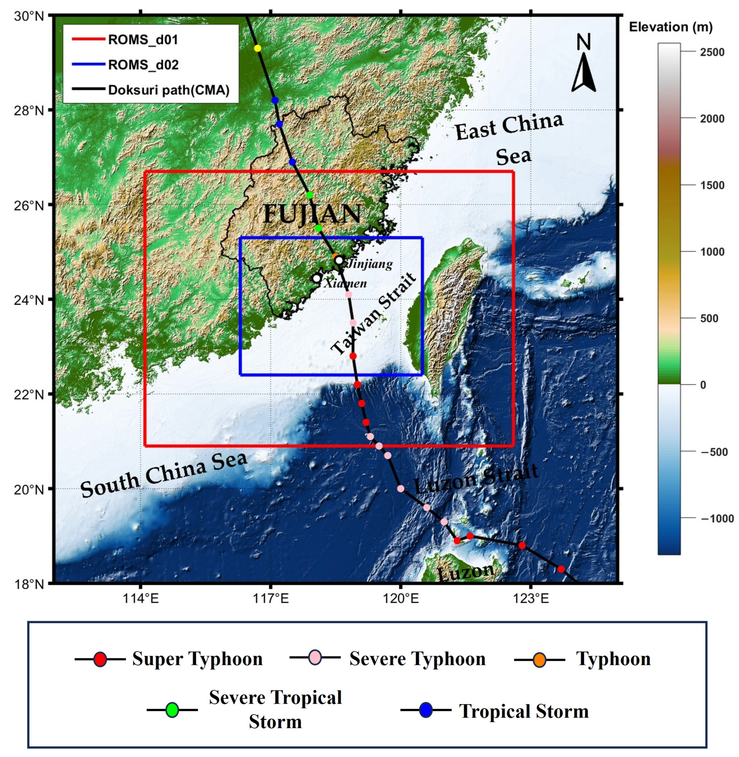
2.1. Data

A collaborative effort involving multiple institutions is focused on developing an eddy-resolving, real-time global and basin-scale ocean hindcast, nowcast, and prediction system using a data-assimilative hybrid isopycnal-sigma-pressure ocean model known as the Hybrid Coordinate Ocean Model (HYCOM). The global ocean forecasting system based on the HYCOM integrates various observational data sources, such as satellite altimeter data, CTDs, XBTs, Argo buoys, and gliders, to provide a high-resolution three-dimensional representation of the ocean state in real time. It also offers boundary conditions for coastal and regional models and global coupled ocean-atmosphere prediction models [30].
In this study, the simulation is initialized using the 41-layer HYCOM + NCODA Global 1/12° Analysis hindcast dataset provided by the Naval Research Laboratory (NRL). This dataset offers high-resolution oceanographic data with a spatial resolution of 0.08° longitude by 0.04° latitude, including variables such as sea surface height, zonal and meridional current velocities, temperature, and salinity, available at three-hour intervals.
As for atmospheric forcing, the study utilized the ERA5 dataset from the European Centre for Medium-Range Weather Forecasts (ECMWF). ERA5 is the fifth generation ECMWF reanalysis dataset, spanning from January 1940 to the present day, with a spatial resolution of 31 km and 137 vertical levels from the surface up to 80 km. ERA5 integrates historical observations with advanced modeling and data assimilation systems to generate consistent and comprehensive climate data [31]. Specifically, ERA5 single-layer data were used for the air–sea boundary condition.
Wave data input is obtained from the Global Ocean Waves Analysis and Forecast product provided by the Copernicus Marine Environment Monitoring Service (CMEMS). This product consists of 3-hourly instantaneous fields of integrated wave parameters derived from the total spectrum (such as significant wave height, wave period, wave direction, etc.), with a spatial resolution of 0.083° × 0.083°. The dataset is created using numerical models and incorporates satellite and in situ observations to produce precise and dependable wave fields [32].

2.2. Model Setup

The numerical simulations are conducted with the Coupled Ocean–Atmosphere–Wave–Sediment Transport (COAWST) modeling system [33,34]. In this study, we utilize only the ocean circulation model component of COAWST, specifically the ROMS, which is coupled with wave forcing derived from offline wave data provided by the CMEMS. The ROMS is a widely used, three-dimensional, free-surface, terrain-following numerical model that solves the Reynolds-averaged Navier–Stokes equations under the hydrostatic and Boussinesq approximations [33,35]. The model incorporates a baroclinic–barotropic mode split, allowing for the explicit fast time-stepping and conservative averaging of barotropic variables. While the present elements of the ROMS remain intact, updates in COAWST have integrated additional terms to account for the effects of wind-driven (primary) surface gravity waves on oceanic currents and turbulence (WEC), thereby expanding its applicability in the study of wave–current interactions [11,35]. The model solves the following wave-averaged momentum equation, which incorporates the vortex force formalism to represent wave forcing [11,36]:
u t + u · 𝛻 u + w u z + f z ^ × u + 𝛻 φ F D + z u w ¯ ν u z = 𝛻 K + J + F w
In Equation (1), ( u , w ) represent the quasi-Eulerian mean velocities, defined as the Lagrangian mean velocity minus the Stokes drift in the Eulerian reference frame for wave averaging (i.e., u = u L u S t ) [37]. 𝛻 is the horizontal differential operator; z ^ is the upward unit vector; f is the Coriolis parameter; φ is the dynamic pressure normalized by the refence density ρ 0 ; F is the non-wave, non-conservative force; D represents the diffusive terms (viscosity and diffusion); and ν is the molecular viscosity. The right-hand side of the equation represents wave forces: K is the Bernoulli head, and J represents the VF term (including both the vortex force and the Coriolis–Stokes force), as expressed in the following equation:
J = z ^ × u S t z ^ · 𝛻 × u + f w S t u z
Both the Bernoulli head and the vortex force are classified as conservative wave effects. Here, to differentiate the vortex force component from the Coriolis–Stokes force within J , we will specifically refer to the vortex force component as the “Stokes vortex force” from this point onward. F w represents the non-conservative wave effects, and in this study, it refers to wave breaking, which is parameterized using the below formula [11]:
F w = ε b ρ 0 σ k · f b ( z )
σ = g k · t a n h ( H )
Here, ε b is the depth-limited wave breaking dissipation [38], σ is the intrinsic frequency, k is the wave number vector, and k is its magnitude. All of these parameters are calculated using the spectrum peak values from the CMEMS dataset. H is the normalized vertical length, and f b ( z ) is a vertical distribution function provided by Thornton and Guza [39].
In addition, the wave-averaged, depth-integrated continuity equation is the following:
ζ t + 𝛻 · U ¯ = ζ ^ t 𝛻 · U ¯ S t
Equation (5) can be rearranged as follows:
ζ c t = ( 𝛻 · U ¯ + 𝛻 · U ¯ S t ) = 𝛻 · U ¯ L
where ζ c = ζ + ζ ^ is the composite water level, with ζ being the wave-averaged water level and ζ ^ being the quasi-static water level caused by the inverse barometric effect and wave setup/set-down. U ¯ L , U ¯ , and U ¯ S t are the depth integrals of Lagrangian flow, Eulerian current, and Stokes drift, respectively:
U ¯ = h ζ + ζ ^ u d z   and   U ¯ S t = h ζ + ζ ^ u S t d z
and the Lagrangian flow is the sum of the Eulerian current and Stokes drift, i.e., U ¯ L = U ¯ + U ¯ S t .
Typhoon Doksuri developed over warm waters east of the Philippines in the northwest Pacific at 1200 UTC on July 21. It subsequently moved northwestward, gradually intensifying into a super typhoon [40]. By July 25, Doksuri reached its peak intensity of 62 m/s. The typhoon then passed over Fuga Island in the Philippines and traversed the Taiwan Strait, making landfall in Jinjiang City, Fujian Province, at approximately 02:00 UTC on July 28, classified as a severe typhoon. To investigate the impact of waves on the surge elevation induced by Doksuri, we selected an appropriate model domain that primarily encompasses the Taiwan Strait and its surrounding areas. This domain is composed of nested grids (Figure 1): the parent grid (d01) with a spatial resolution of 3 km and the child grid (d02) with a spatial resolution of 1 km. Both grids consist of 40 sigma layers, and the bathymetry is derived from the 15 arc-second GEBCO global bathymetric dataset. The baroclinic time step was set to 90 s for the parent grid and 30 s for the receiver grid, with the barotropic time step being one-thirtieth of these values to ensure compliance with the CFL condition (i.e., the maximum barotropic Courant number was kept below 10 2 ). Nudging was applied to values from HYCOM solutions near the boundaries, and the astronomical tides were not considered in this study to filter the periodic and rotary signals [17]. The simulation period spanned 10 days (from UTC 20 July 2023 to 30 July 2023) to ensure comprehensive coverage of Doksuri’s progression into the study area, including its landfall and subsequent dissipation. The bottom boundary layer was parameterized using a logarithmic profile with a characteristic bottom roughness height of 0.002 m. K-Profile Parameterization (KPP) [41] was applied for the vertical mixing coefficient calculations.
Two numerical experiments were conducted in which the initial fields, boundary conditions, atmospheric forcing, and other model parameters were kept consistent across both experiments. The only difference was that one experiment incorporated surface wave effects while the other excluded them. The comparison between the experiments with and without waves helps highlight the impact of wave dynamics on storm surge. We have placed the preliminary validation results of the model in the Supplementary Materials

3. Results

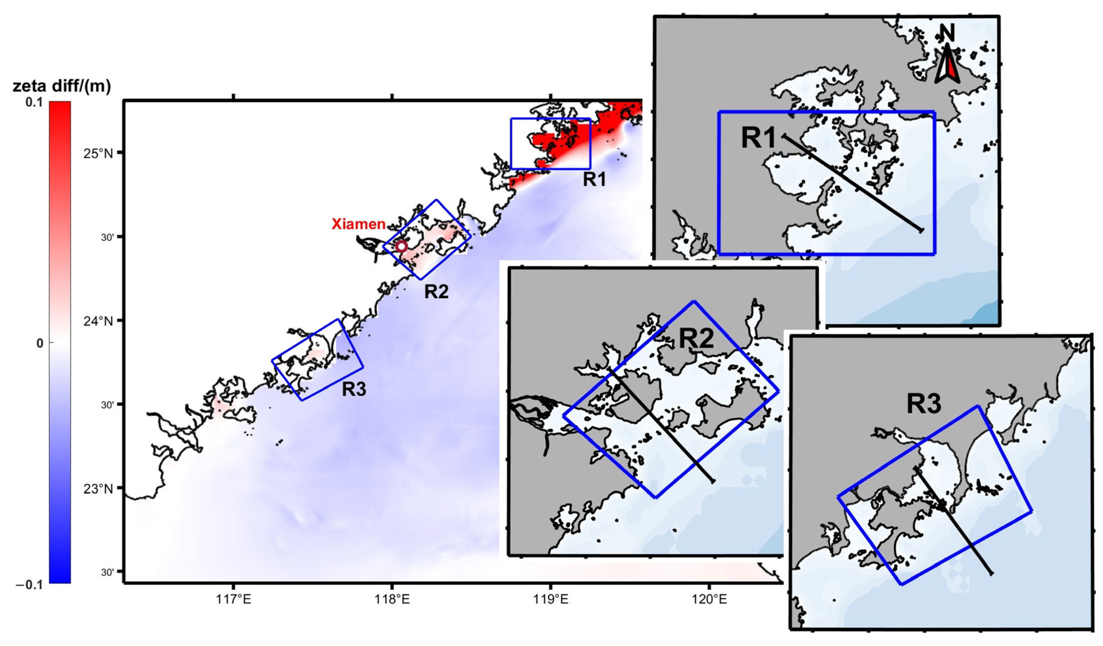
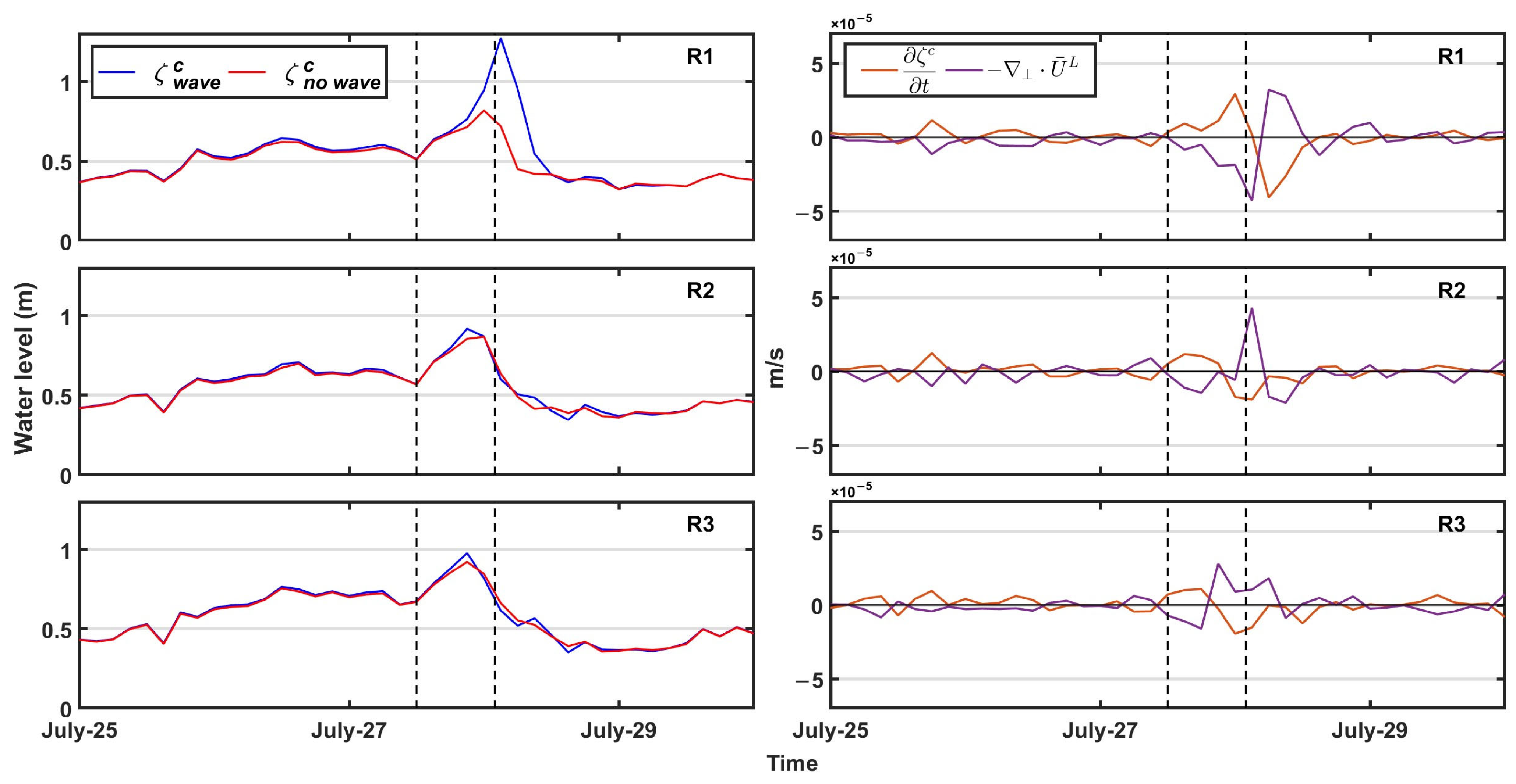
3.1. Nearshore Water Level Change

Given our particular interest in the nearshore water level during the typhoon’s landfall, we selected three coastal areas for detailed examination, designated as R1, R2, and R3 (Figure 2). Specifically, R1 is positioned in the region to the northeast of the typhoon’s forward direction, while R2 and R3 are located to the northwest, with R2 being adjacent to the typhoon’s trajectory.
During the landfall of Typhoon Doksuri, the strong counterclockwise winds resulted in maximum wave heights in the R1 region (Figure 3a), where the Stokes drift is also the strongest among the three regions (Figure 3b). In contrast, the wind directions in the R2 and R3 regions are either along the coast or offshore, resulting in lower wave energy and significantly smaller Stokes drifts compared to R1.
The water level difference between the cases with and without waves was most pronounced in the R1 region during the passage of the typhoon. We used the following formula to calculate the average wave contribution ( C w a v e ) to the water level:
C w a v e = 1 n ( i = 1 n ζ w a v e i ζ n o w a v e i ζ n o w a v e i )
Here, ζ w a v e i and ζ n o w a v e i represent the water level with and without waves at time t i , respectively; and n is the number of samples during the typhoon passage (i.e., the time period between the two vertical dashed lines shown in Figure 4). We computed the average volume transport divergence in R1, R2, and R3 without wave coupling during the period when the typhoon entered the model domain and made landfall along the Fujian coastline. The results showed that water mass convergence occurred in three regions, suggesting that even in the absence of waves, onshore water transport could still lead to elevated water levels. In the case of wave conditions, the water level with waves increased by 17.17% on average compared to the level without waves in R1. In contrast, regions R2 and R3 exhibited only slight increases of 2.69% and 2.71% in the water level on average, respectively, both below 5%. This indicates that the effects of waves in these regions were negligible. This demonstrates that surface wave effects on the storm surge cannot be ignored to the right of the typhoon’s path (i.e., region R1), as they are consistent with big waves and large Stokes drift in this region (Figure 3). This demonstrates that in Fujian coastal areas, the effects of surface waves on storm surge cannot be ignored in the northeastern quadrant of the typhoon’s path (i.e., region R1). In this area, high surface wind speeds and the prevailing wind direction strike the coastline at either an oblique or perpendicular angle. Such wind conditions contribute to the generation of large wave heights and substantial Stokes drift in this area, as illustrated in Figure 3.
Further, the pronounced increase in the water level in the R1 region with waves is partly due to the strong onshore Stokes drift (Figure 3b), which transports water shoreward. To quantitatively assess the average contribution of Stokes drift to the water level change, we employed the formula below:
C s t k = t 0 t 1 ( 𝛻 · U ¯ S t ) d t ζ w a v e t 1 ζ w a v e t 0
where t 0 and t 1 denote the times at which the typhoon enters the child domain d02 and makes landfall (marked by the vertical dashed lines shown in Figure 4), respectively. The contribution of Stokes drift to the increase in water level is about 38.15% in R1, 29.31% in R2, and 2.59% in R3. Interestingly, Stokes drift contributes significantly to the water level increase in R2; however, the total water level difference between the conditions with and without waves is insignificant in this region. This implies that the Eulerian currents are modified by waves and largely offset the contribution of Stokes drift to the water level. Additionally, the small Stokes drift contribution in R3 is consistent with the negligible Stokes drift in this region (Figure 3b). This indicates that Stokes drift is important to the increase in water level during the typhoon passage.

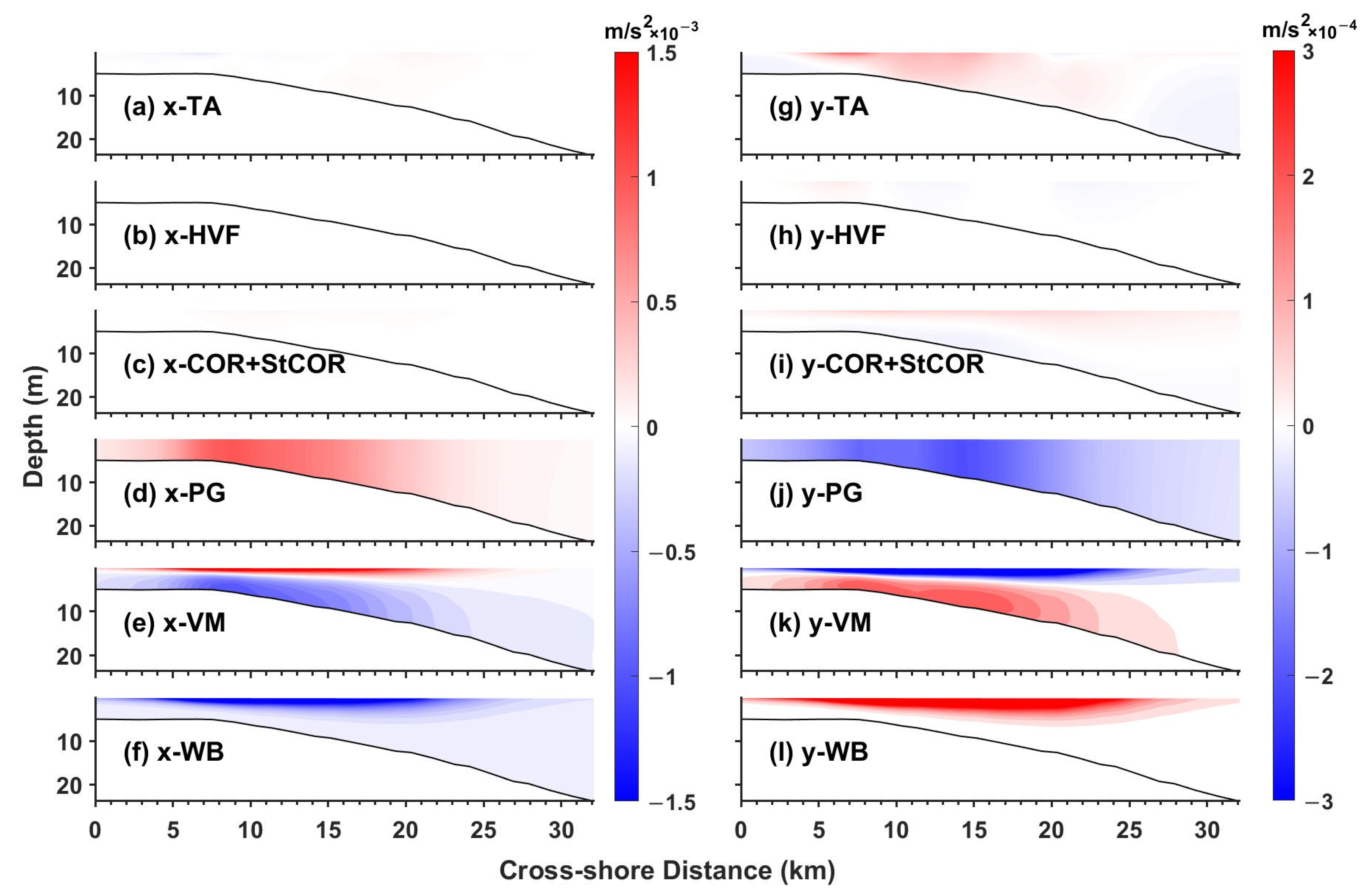
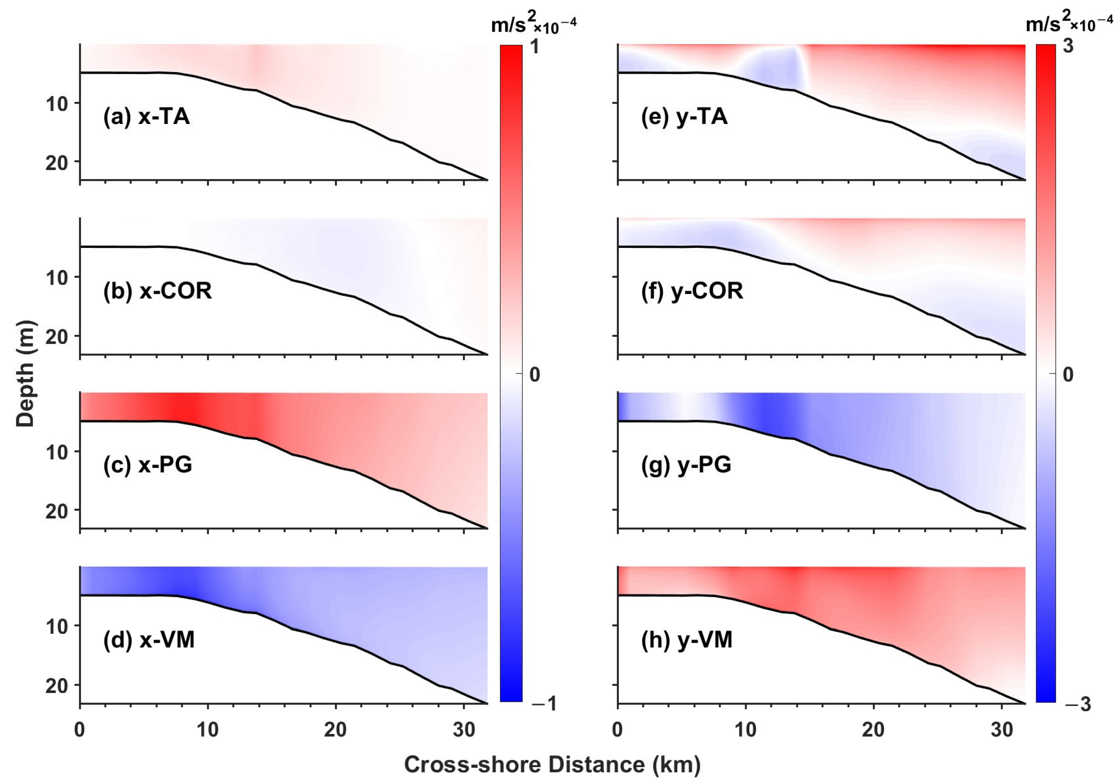
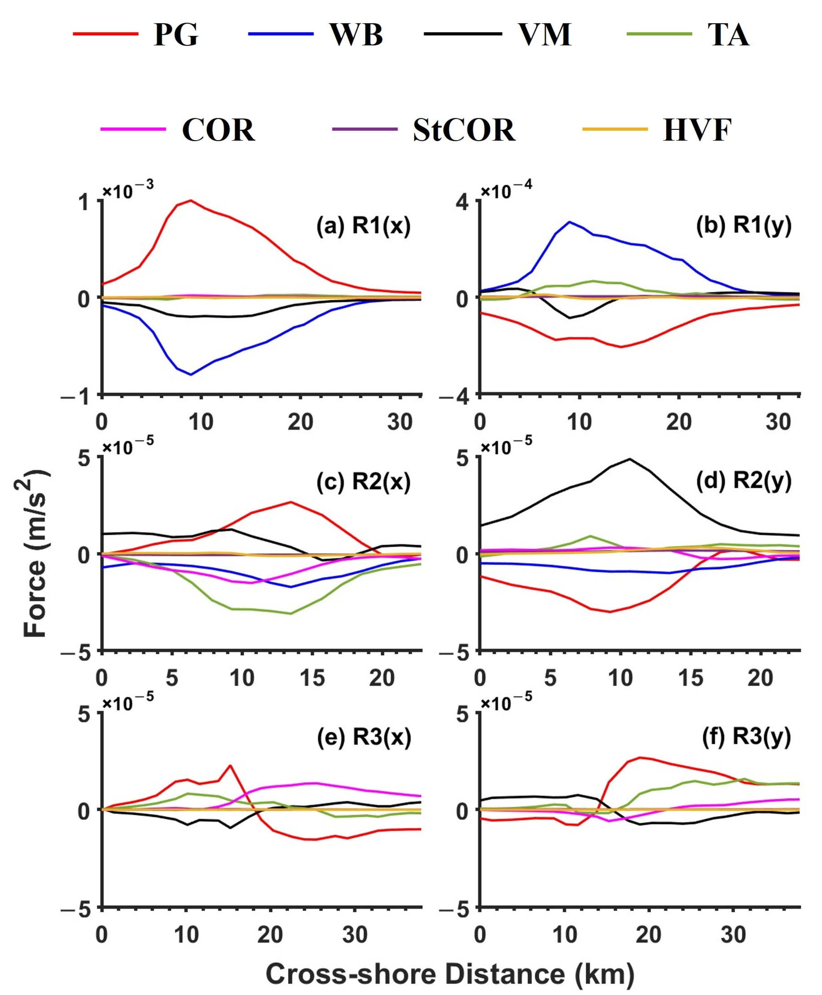
3.2. Momentum Balance in the Nearshore Shallow Water

We selected three sections oriented perpendicularly to the shore in regions R1, R2, and R3 (Figure 2). For the sake of clarity in expression, we rotated the x–y plane of the Cartesian coordinate system clockwise so that the x-axis aligns with the direction of the cross-shore profiles. Consequently, the positive x-axis now points seaward, while the positive y-axis indicates the direction from low latitude to high latitude along the shore. This rotational transformation was also applied to the vector field; from this point forward, we will denote the current velocities in the cross-shore direction (x) and along-shore direction (y) as u and v, respectively. The momentum analysis was conducted in both the cross-shore (x) and along-shore (y) directions.
Below, we mainly focus on region R1 as it exhibits the most pronounced water level changes caused by waves. In the experiment with waves, the nearshore 3D momentum equation is dominated by wave breaking, vertical mixing, and pressure-gradient force in both cross-shore and along-shore directions (Figure 5). Wave breaking yields a strong breaker force near the surface. The cross-shore breaker force is negative because in this region the waves propagate northwestward with an onshore propagating component (Figure 3a). Furthermore, the Stokes vortex forces and Coriolis–Stokes force are insignificant compared to the wave breaker force. Namely, wave breaking dominates over Stokes forces in the nearshore momentum equation for this storm surge.
In the experiment without waves (Figure 6), the dominant forces are the pressure-gradient force and vertical mixing in both the along-shore and cross-shore directions. In the absence of wave forces, particularly the wave breaker force, the magnitude of dominant forces is about O(10) times smaller than the forces with waves.
The depth-averaged momentum equation terms were analyzed for three regions (Figure 7). In the R1 region, where wave effects are most pronounced, wave breaking is a dominant force and is O(100) times larger than Coriolis–Stokes force and Stokes vortex force (Figure 7a,b). Contrastingly, in the R2 and R3 regions, wave breaking is greatly reduced compared to the R1 region (Figure 7c–f); particularly in the R3 region, the wave breaking is negligible due to small waves (Figure 3a). Furthermore, both the Coriolis–Stokes force and the Stokes vortex force are negligible in all three regions, again suggesting that Stokes forces are unimportant to the nearshore momentum equation for this storm surge.

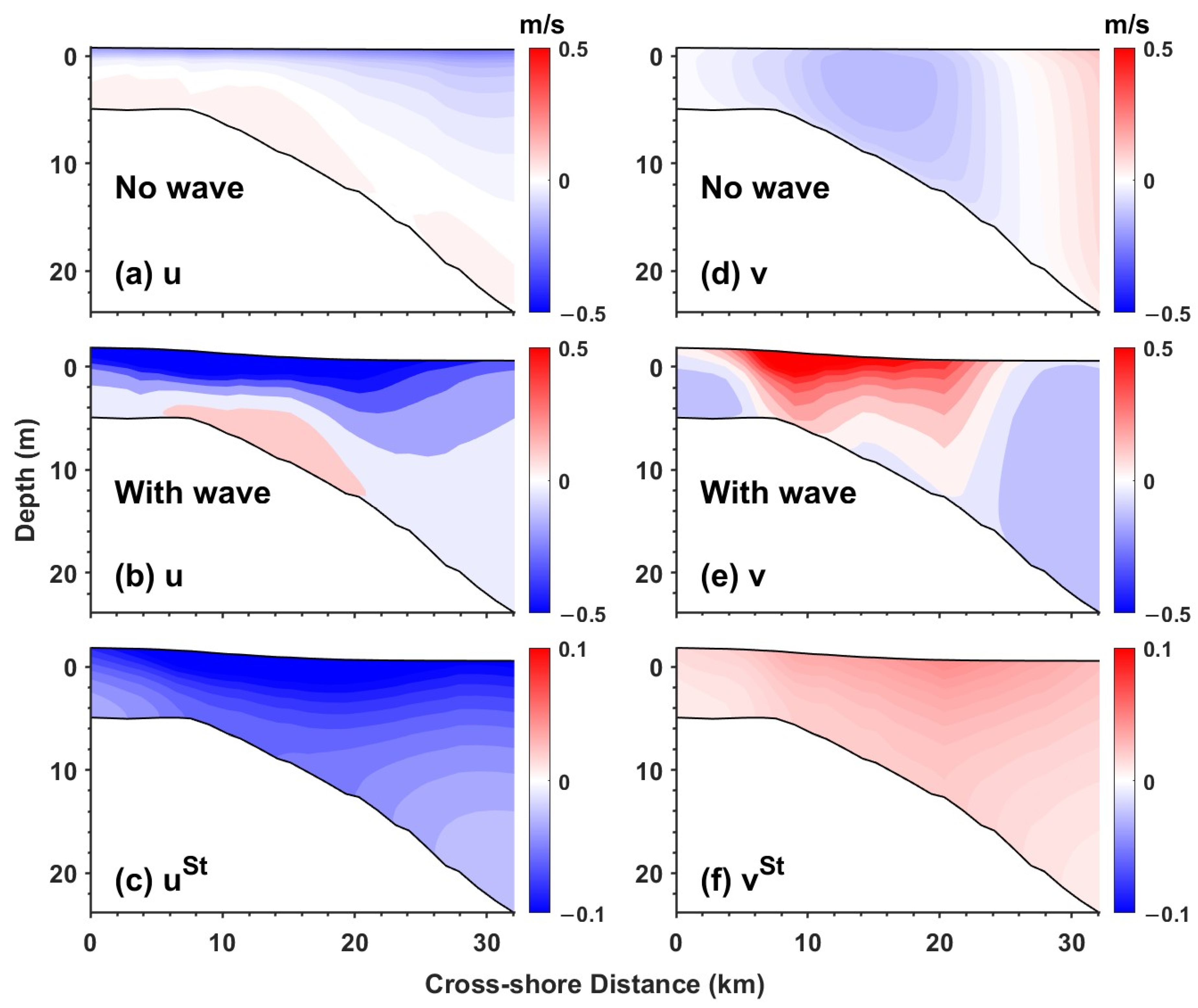
3.3. Nearshore Flow Structures

The near-surface onshore current with waves is about three times larger in magnitude than that without waves in the R1 region (Figure 8a,b), as the shoreward wave breaker force accelerates the onshore current. The onshore current enhanced by waves further increases the onshore water transport, elevating the nearshore water level; therefore, the water level with waves is higher than that without waves in the R1 region (Figure 4). In addition, the onshore Stokes drift also transports water shoreward (Figure 8c), further elevating the nearshore water level.
The direction of the along-shore current is opposite in the experiments with and without waves (Figure 8d,e). In the experiment with waves, the positive wave breaker force primarily affects the surface layer within the wave breaking zone (Figure 5l), leading to significant differences in the nearshore flow structure between experiments with and without waves, as illustrated in Figure 8d,e. In the condition with waves, a positive longshore current is generated, aligning with the direction of the strong wave breaker force in the surf zone. By contrast, in the experiment without waves, the negative along-shore pressure-gradient force prevails, resulting in a negative along-shore current.

4. Discussion and Conclusions

In this study, we investigated the conservative and non-conservative wave effects on storm surge during Typhoon Doksuri. The contribution of waves to storm surge was significantly influenced by factors such as wave height and wave direction, resulting in considerable spatial variability.
The water level with waves in the R1 region significantly increased by 17.17% on average compared to that without waves, consistent with previous findings [13,17,28,42]. Additionally, Stokes drift contributed to 38.15% of the water level increase in the R1 region, suggesting that Stokes drift is important to the water level increase during the storm surge.
The R1 region is in the area to the northeast of the typhoon’s track, where wave heights and Stokes drift are the greatest among the three regions (Figure 3). Additionally, big waves in the R1 region induce strong wave breaking, enhancing the onshore current. Therefore, the enhanced onshore current and strong onshore Stokes drift together increase shoreward water transport, leading to a higher water level than that without waves. Moreover, wave breaking is the dominant wave effect in the nearshore momentum equation, and it markedly affects the nearshore circulation during the storm surge.
The R2 and R3 regions are located on the northwestern side of the typhoon path, where wave heights and onshore Stokes drift are substantially smaller than those in the R1 region (Figure 3). Consequently, wave breaking is less important in the two regions, and particularly, it is negligible in the R3 region, leading to insignificant enhancement of onshore currents by wave breaking. Furthermore, the weak onshore Stokes drift contributes little to shoreward water transport. Therefore, surface wave effects are unimportant to the water level change in the R2 and R3 regions.
In regions with significant wave effects (e.g., region R1), non-conservative wave effects, such as wave breaking, are two orders of magnitude larger than conservative wave effects like the Coriolis–Stokes force and Stokes vortex force (Figure 8). In the condition with waves, strong wave breaking led to higher pressure-head adjustment and enhanced vertical mixing, with the magnitude of this adjustment being an order of magnitude greater than in the condition without waves, as shown in Figure 6 and Figure 7. These results demonstrate that incorporating wave effects into storm surge simulations significantly impacts the momentum balance and the flow field structure. Moreover, non-conservative wave effects play a dominant role in contributing to the storm surge.
Despite the novel insight into quantifying the contribution of waves provided by this study, several limitations should be acknowledged:
  • Previous studies have shown that ERA5 reanalysis data tend to underestimate the intensity of tropical cyclones [43,44,45], which directly leads to simulated water levels being lower than the observed maximum surge. This limitation may affect the accuracy of storm surge simulations in the present study.
  • In this study, we used the spectrum peak values from CMEMS data to calculate wave–current interactions. This monochromatic assumption is commonly employed to obtain quick, rough estimates of wave characteristics and their effects in shallow and deep water conditions and is often applied in ocean engineering and coastal engineering [46]. However, it is important to highlight the limitations of this modeling approach; that is, the simplification of wave characteristics prevents the model from capturing the second-order nonlinear properties of surface gravity waves. In contrast, considering the full wave spectrum provides crucial information about the distribution of energy across a broad range of frequencies and directions. This is essential for accurately modeling wave–current interactions, such as Langmuir circulation and rip currents [47]. Therefore, coupling the wave–current model with a finer grid resolution would better capture nearshore wave spectrum dynamics and improve the representation of wave-induced contributions to storm surge processes.
  • Other non-conservative wave effects, such as wave streaming and wave-enhanced bottom stress, were not considered in this study. For example, previous studies showed that wave streaming enhances onshore transport near the bottom, which can potentially affect the nearshore water level [26]. In addition, wave-enhanced bottom stress is also a critical factor influencing storm surge, particularly in shallow water depths [17,48].
Future studies should incorporate these factors to develop a more comprehensive understanding of the interactions between wave effects and storm surges.

Supplementary Materials

The following supporting information can be downloaded at: https://www.mdpi.com/article/10.3390/jmse13030478/s1.

Author Contributions

Conceptualization, P.W.; methodology, P.W.; software, Z.P.; formal analysis, Z.P.; resources, P.W.; writing—original draft preparation, Z.P.; writing—review and editing, P.W.; visualization, Z.P.; supervision, P.W.; project administration, P.W.; funding acquisition, P.W. All authors have read and agreed to the published version of the manuscript.

Funding

This research was funded by the National Key Research and Development Program of China (Grant Nos. 2023YFC3008200 and 2024YFC3013200), and the National Natural Science Foundation of China (NSFC) (Grant No. 42206017).

Institutional Review Board Statement

Not applicable.

Informed Consent Statement

Not applicable.

Data Availability Statement

The dataset will be available from the authors upon request. The data used in this study are openly available as follows: HYCOM + NCODA Global 1/12° Analysis hindcast dataset: The original data are available at the Naval Research Laboratory (NRL) THREDDS Data Server at http://tds.hycom.org/ (accessed on 15 March 2024). ERA5 dataset: The data used for atmospheric forcing are available from the European Centre for Medium-Range Weather Forecasts (ECMWF) and can be accessed at https://cds.climate.copernicus.eu/datasets (accessed on 18 March 2024). Global Ocean Waves Analysis and Forecast product: The wave data are provided by the Copernicus Marine Environment Monitoring Service (CMEMS) and can be accessed at https://data.marine.copernicus.eu/products (accessed on 25 March 2024). The raw numerical experiment data supporting the conclusions of this article will be made available by the authors on request.

Acknowledgments

The authors would like to express sincere gratitude to Yusuke Uchiyama and John C. Warner for their valuable suggestions and comments on the numerical simulations.

Conflicts of Interest

The authors declare no conflicts of interest. The funders had no role in the design of the study; in the collection, analyses, or interpretation of data; in the writing of the manuscript; or in the decision to publish the results.

References

  1. GB/T 30746-2014; Technical Directives for the Disaster Prevention and Mitigation of Storm Surge. Chinese National Standard: Beijing, China, 2014.
  2. Harris, D.L. Characteristics of the Hurricane Storm Surge; Department of Commerce, Weather Bureau: Washington, DC, USA, 1963. [Google Scholar]
  3. Vousdoukas, M.I.; Voukouvalas, E.; Annunziato, A.; Giardino, A.; Feyen, L.J.C.D. Projections of extreme storm surge levels along Europe. Clim. Dyn. 2016, 47, 3171–3190. [Google Scholar] [CrossRef]
  4. von Storch, H.; Woth, K. Storm surges: Perspectives and options. Sustain. Sci. 2008, 3, 33–43. [Google Scholar] [CrossRef]
  5. Kim, S.Y.; Yasuda, T.; Mase, H. Numerical analysis of effects of tidal variations on storm surges and waves. Appl. Ocean. Res. 2008, 30, 311–322. [Google Scholar] [CrossRef]
  6. García-León, M.; Sotillo, M.G.; Mestres, M.; Espino, M.; Fanjul, E.Á. Improving Operational Ocean Models for the Spanish Port Authorities: Assessment of the SAMOA Coastal Forecasting Service Upgrades. J. Mar. Sci. Eng. 2022, 10, 149. [Google Scholar] [CrossRef]
  7. Sotillo, M.G.; Mourre, B.; Mestres, M.; Lorente, P.; Aznar, R.; García-León, M.; Liste, M.; Santana, A.; Espino, M.; Álvarez, E. Evaluation of the Operational CMEMS and Coastal Downstream Ocean Forecasting Services During the Storm Gloria (January 2020). Front. Mar. Sci. 2021, 8, 644525. [Google Scholar] [CrossRef]
  8. Longuet-Higgins, M.S.; Stewart, R. Radiation stresses in water waves; A physical discussion, with applications. In Deep Sea Research and Oceanographic Abstracts; Elsevier: Amsterdam, The Netherlands, 1964; pp. 529–562. [Google Scholar]
  9. McWilliams, J.C.; Restrepo, J.M.; Lane, E.M. An asymptotic theory for the interaction of waves and currents in coastal waters. J. Fluid Mech. 2004, 511, 135–178. [Google Scholar] [CrossRef]
  10. Mellor, G. The Three-Dimensional Current and Surface Wave Equations. J. Phys. Oceanogr. 2003, 33, 1978–1989. [Google Scholar] [CrossRef]
  11. Uchiyama, Y.; McWilliams, J.C.; Shchepetkin, A.F. Wave–current interaction in an oceanic circulation model with a vortex-force formalism: Application to the surf zone. Ocean. Model. 2010, 34, 16–35. [Google Scholar] [CrossRef]
  12. Xie, L.; Liu, H.; Peng, M. The effect of wave–current interactions on the storm surge and inundation in Charleston Harbor during Hurricane Hugo 1989. Ocean. Model. 2008, 20, 252–269. [Google Scholar] [CrossRef]
  13. Beardsley, R.C.; Chen, C.; Xu, Q. Coastal flooding in Scituate (MA): A FVCOM study of the 27 December 2010 nor’easter. J. Geophys. Res. Ocean. 2013, 118, 6030–6045. [Google Scholar] [CrossRef]
  14. Rong, Z.; Hetland, R.D.; Zhang, W.; Zhang, X. Current–wave interaction in the Mississippi–Atchafalaya river plume on the Texas–Louisiana shelf. Ocean Model. 2014, 84, 67–83. [Google Scholar] [CrossRef]
  15. Sun, Y.; Chen, C.; Beardsley, R.C.; Xu, Q.; Qi, J.; Lin, H. Impact of current-wave interaction on storm surge simulation: A case study for Hurricane Bob. J. Geophys. Res. Ocean. 2013, 118, 2685–2701. [Google Scholar] [CrossRef]
  16. Lavaud, L.; Bertin, X.; Martins, K.; Arnaud, G.; Bouin, M.-N. The contribution of short-wave breaking to storm surges: The case Klaus in the Southern Bay of Biscay. Ocean Model. 2020, 156, 101710. [Google Scholar] [CrossRef]
  17. Mo, D.; Hu, P.; Li, J.; Hou, Y.; Li, S. Effect of Wave-Dependent Mechanisms on Storm Surge and Current Simulation during Three Extreme Weather Systems. J. Phys. Oceanogr. 2024, 54, 1519–1543. [Google Scholar] [CrossRef]
  18. Feng, J.; Lu, X.; Yu, H.; Zhang, W.; Ying, M.; Fan, Y.; Zhu, Y.; Chen, D. An Overview of the China Meteorological Administration Tropical Cyclone Database. J. Atmos. Ocean. Technol. 2014, 31, 287–301. [Google Scholar] [CrossRef]
  19. Lu, X.; Yu, H.; Ying, M.; Zhao, B.; Zhang, S.; Lin, L.; Bai, L.; Wan, R. Western North Pacific Tropical Cyclone Database Created by the China Meteorological Administration. Adv. Atmos. Sci. 2021, 38, 690–699. [Google Scholar] [CrossRef]
  20. Leibovich, S. On wave-current interaction theories of Langmuir circulations. J. Fluid Mech. 1980, 99, 715–724. [Google Scholar] [CrossRef]
  21. Hasselmann, K. On the mass and momentum transfer between short gravity waves and larger-scale motions. J. Fluid Mech. 1971, 50, 189–205. [Google Scholar] [CrossRef]
  22. Wang, P.; McWilliams, J.C.; Wang, D.; Yi, D.L. Conservative Surface Wave Effects on a Wind-Driven Coastal Upwelling System. J. Phys. Oceanogr. 2023, 53, 37–55. [Google Scholar] [CrossRef]
  23. Dalrymple, R.A.; MacMahan, J.H.; Reniers, A.J.; Nelko, V.J. Rip currents. Annu. Rev. Fluid Mech. 2011, 43, 551–581. [Google Scholar] [CrossRef]
  24. MacMahan, J.H.; Thornton, E.B.; Reniers, A.J.H.M. Rip current review. Coast. Eng. 2006, 53, 191–208. [Google Scholar] [CrossRef]
  25. Uchiyama, Y.; McWilliams, J.C.; Akan, C. Three-dimensional transient rip currents: Bathymetric excitation of low-frequency intrinsic variability. J. Geophys. Res. Ocean. 2017, 122, 5826–5849. [Google Scholar] [CrossRef]
  26. Wang, P.; McWilliams, J.C.; Uchiyama, Y.; Chekroun, M.D.; Yi, D.L. Effects of Wave Streaming and Wave Variations on Nearshore Wave-Driven Circulation. J. Phys. Oceanogr. 2020, 50, 3025–3041. [Google Scholar] [CrossRef]
  27. Wang, P.; McWilliams, J.C.; Uchiyama, Y. A Nearshore Oceanic Front Induced By Wave Streaming. J. Phys. Oceanogr. 2021, 51, 1967–1984. [Google Scholar] [CrossRef]
  28. Yu, X.; Pan, W.; Zheng, X.; Zhou, S.; Tao, X. Effects of wave-current interaction on storm surge in the Taiwan Strait: Insights from Typhoon Morakot. Cont. Shelf Res. 2017, 146, 47–57. [Google Scholar] [CrossRef]
  29. Romero, L.; Hypolite, D.; McWilliams, J.C. Representing wave effects on currents. Ocean Model. 2021, 167, 101873. [Google Scholar] [CrossRef]
  30. Chassignet, E.P.; Hurlburt, H.E.; Smedstad, O.M.; Halliwell, G.R.; Hogan, P.J.; Wallcraft, A.J.; Baraille, R.; Bleck, R. The HYCOM (HYbrid Coordinate Ocean Model) data assimilative system. J. Mar. Syst. 2007, 65, 60–83. [Google Scholar] [CrossRef]
  31. Hersbach, H.; Bell, B.; Berrisford, P.; Hirahara, S.; Horányi, A.; Muñoz-Sabater, J.; Nicolas, J.; Peubey, C.; Radu, R.; Schepers, D.; et al. The ERA5 global reanalysis. Q. J. R. Meteorol. Soc. 2020, 146, 1999–2049. [Google Scholar] [CrossRef]
  32. Le Traon, P.Y.; Reppucci, A.; Alvarez Fanjul, E.; Aouf, L.; Behrens, A.; Belmonte, M.; Bentamy, A.; Bertino, L.; Brando, V.E.; Kreiner, M.B.; et al. From Observation to Information and Users: The Copernicus Marine Service Perspective. Front. Mar. Sci. 2019, 6, 00234. [Google Scholar] [CrossRef]
  33. Warner, J.C.; Sherwood, C.R.; Signell, R.P.; Harris, C.K.; Arango, H.G. Development of a three-dimensional, regional, coupled wave, current, and sediment-transport model. Comput. Geosci. 2008, 34, 1284–1306. [Google Scholar] [CrossRef]
  34. Warner, J.C.; Armstrong, B.; He, R.; Zambon, J.B. Development of a Coupled Ocean–Atmosphere–Wave–Sediment Transport (COAWST) Modeling System. Ocean Model. 2010, 35, 230–244. [Google Scholar] [CrossRef]
  35. Shchepetkin, A.F.; McWilliams, J.C. The regional oceanic modeling system (ROMS): A split-explicit, free-surface, topography-following-coordinate oceanic model. Ocean Model. 2005, 9, 347–404. [Google Scholar] [CrossRef]
  36. Kumar, N.; Voulgaris, G.; Warner, J.C.; Olabarrieta, M. Implementation of the vortex force formalism in the coupled ocean-atmosphere-wave-sediment transport (COAWST) modeling system for inner shelf and surf zone applications. Ocean Model. 2012, 47, 65–95. [Google Scholar] [CrossRef]
  37. Jenkins, A.D. The use of a wave prediction model for driving a near-surface current model. Dtsch. Hydrogr. Z. 1989, 42, 133–149. [Google Scholar] [CrossRef]
  38. Thornton, E.B.; Guza, R.T. Transformation of wave height distribution. J. Geophys. Res. Ocean. 1983, 88, 5925–5938. [Google Scholar] [CrossRef]
  39. Thornton, E.B.; Guza, R.T. Surf Zone Longshore Currents and Random Waves: Field Data and Models. J. Phys. Oceanogr. 1986, 16, 1165–1178. [Google Scholar] [CrossRef]
  40. Wang, Q.; Zhao, D.; Duan, Y.; Wang, H.; Sun, Z.; Xu, Y. Observational fine-scale evolutionary characteristics of concentric eyewall Typhoon Doksuri (2023). Atmos. Res. 2024, 310, 107630. [Google Scholar] [CrossRef]
  41. Large, W.G.; McWilliams, J.C.; Doney, S.C. Oceanic vertical mixing: A review and a model with a nonlocal boundary layer parameterization. Rev. Geophys. 1994, 32, 363–403. [Google Scholar] [CrossRef]
  42. Sheng, Y.P.; Alymov, V.; Paramygin, V.A. Simulation of storm surge, wave, currents, and inundation in the Outer Banks and Chesapeake Bay during Hurricane Isabel in 2003: The importance of waves. J. Geophys. Res. Ocean. 2010, 115. [Google Scholar] [CrossRef]
  43. Dulac, W.; Cattiaux, J.; Chauvin, F.; Bourdin, S.; Fromang, S. Assessing the representation of tropical cyclones in ERA5 with the CNRM tracker. Clim. Dyn. 2023, 62, 223–238. [Google Scholar] [CrossRef]
  44. Faranda, D.; Messori, G.; Bourdin, S.; Vrac, M.; Thao, S.; Riboldi, J.; Fromang, S.; Yiou, P. Correcting biases in tropical cyclone intensities in low-resolution datasets using dynamical systems metrics. Clim. Dyn. 2023, 61, 4393–4409. [Google Scholar] [CrossRef]
  45. Slocum, C.J.; Razin, M.N.; Knaff, J.A.; Stow, J.P. Does ERA5 Mark a New Era for Resolving the Tropical Cyclone Environment? J. Clim. 2022, 35, 7147–7164. [Google Scholar] [CrossRef]
  46. Dean, R.G.; Dalrymple, R.A. Water Wave Mechanics for Engineers and Scientists; World Scientific Publishing Company: Singapore, 1991; Volume 2. [Google Scholar]
  47. Craik, A.D.D.; Leibovich, S. A rational model for Langmuir circulations. J. Fluid Mech. 1976, 73, 401–426. [Google Scholar] [CrossRef]
  48. Bertin, X.; Li, K.; Roland, A.; Bidlot, J.-R. The contribution of short-waves in storm surges: Two case studies in the Bay of Biscay. Cont. Shelf Res. 2015, 96, 1–15. [Google Scholar] [CrossRef]
Figure 2. Differences in water level between simulations with and without waves (zeta_wave-zeta_nowave) during the Doksuri landfall. Three regions of interest along the coast are designated by blue contouring as R1, R2, and R3. The solid black lines shown in the three nearshore regions denote the sections used for supmomentum analysis.
Jmse 13 00478 g002
Figure 3. During the period of Typhoon landfall, (a) sea surface wind field is denoted by arrows and wave heights are denoted by color, and (b) depth-averaged Stokes drift.
Jmse 13 00478 g003
Figure 4. Evolutions of spatially averaged water levels from experiments with and without waves across three regions (left column) and the two terms in the continuity Equation (6) for the experiment with waves (right column). The vertical dashed lines indicate the period from Doksuri’s entry into the child domain until landfall.
Jmse 13 00478 g004
Figure 5. Time-average terms of momentum equation with waves in the cross-shore (left column) and along-shore (right column) directions along the R1 section, during Doksuri’s landfall. (a,g) Total acceleration, (b,h) horizontal vortex force, (c,i) Coriolis force and Coriolis–Stokes force, (d,j) pressure-gradient force, (e,k) vertical mixing, and (f,l) wave breaking. The total acceleration (TA) is the sum of local acceleration, Eulerian advection, and Stokes advection.
Jmse 13 00478 g005
Figure 6. Time-average terms of momentum equation without waves in the cross-shore (left column) and along-shore (right column) directions along the R1 section, during Doksuri’s landfall. (a,e) Total acceleration, (b,f) Coriolis force, (c,g) pressure-gradient force, and (d,h) vertical mixing.
Jmse 13 00478 g006
Figure 7. Depth-average terms of momentum equation with waves in the cross-shore (left column) and along-shore (right column) directions along the (top panel) R1, (mid panel) R2, and (bottom panel) R3 sections.
Jmse 13 00478 g007
Figure 8. (a,d) Eulerian velocity without waves, (b,e) Eulerian velocity, and (c,f) Stokes drift with waves in region R1.
Jmse 13 00478 g008
Disclaimer/Publisher’s Note: The statements, opinions and data contained in all publications are solely those of the individual author(s) and contributor(s) and not of MDPI and/or the editor(s). MDPI and/or the editor(s) disclaim responsibility for any injury to people or property resulting from any ideas, methods, instructions or products referred to in the content.

