1. Introduction
The South China Sea (SCS) has undergone a complex tectonic history since the Mesozoic, including repeated episodes of plate convergence, collision, lateral escape, and continental rifting. These processes led to the development of diverse extensional, compressional, and strike-slip–extensional fault systems, which controlled the formation of three main classes of sedimentary basins: rift-related, strike-slip-related, and compression-related. The SCS is bounded by three major subduction–collision belts—the West Pacific subduction–collision zone, the Sumatra–Java subduction zone, and the Sulawesi–Banda Sea arc–continent subduction zone (
Figure 1), resulting in a highly intricate geodynamic framework [
1,
2,
3,
4,
5,
6,
7,
8,
9].
Over the past decades, several geodynamic models have been proposed to explain the opening of the SCS, each emphasizing a different driving mechanism. Rift-extension models (e.g., Taylor et al. (1980) [
1]) view the SCS as a product of intracontinental stretching and passive-margin-type seafloor spreading. Extrusion–escape models (e.g., Tapponnier (1986) [
2]) attribute spreading to the lateral extrusion of Indochina and surrounding blocks following the India–Eurasia collision. Continental-margin rifting models (e.g., Hamilton (1979) [
3] and Liu (1992) [
4]) consider the basin to have formed by progressive rifting of the South China continental margin itself. In contrast, subduction–drag models (e.g., Hamilton (1979) [
3] and Holloway (1982) [
5]) link the initiation of spreading to the rollback and eventual closure of the Paleo-South China Sea (Paleo-SCS) to the south, which generated extensional stress on the overriding plate and triggered opening of the modern SCS. Although each model explains part of the geological record [
1,
2,
3,
4,
5,
6,
7], none of them fully explain all lines of geological evidence such as the asymmetric spreading fabrics, diachronous breakup unconformities, and the timing of cessation relative to Borneo-margin orogenesis. For the Beikang Basin, which lies on the southern SCS margin adjacent to the subducted Paleo-SCS slab, the subduction–drag mechanism offers the most plausible first-order geodynamic driver [
8,
9,
10,
11,
12,
13,
14]: it naturally explains the southward younging of rift systems, the mid-Miocene cessation of spreading coincident with the Sabah orogenic pulse, and the presence of compressional-inversion structures overprinting earlier extensional faults. We therefore adopt the Paleo-SCS subduction–drag model as the regional geodynamic framework for reconstructing the tectono-stratigraphic evolution of the Beikang Basin.
In this manuscript, we integrate newly acquired and interpreted high-resolution two-dimensional (2D) seismic data with previous regional constraints to
Establish the typical structural styles and the characteristics of seismic and depositional facies of the Beikang Basin;
Propose a four-stage tectonic evolution model (late Paleocene–middle Eocene initial rifting, late Eocene–early Oligocene inherited rifting, late Oligocene–early Miocene climax rifting, and middle Miocene–present post-rift thermal subsidence);
Explore sedimentary evolution under structural controls. Our results help to provide fundamental data for deep-water oil and gas exploration in the Beikang Basin.
2. Geological Background
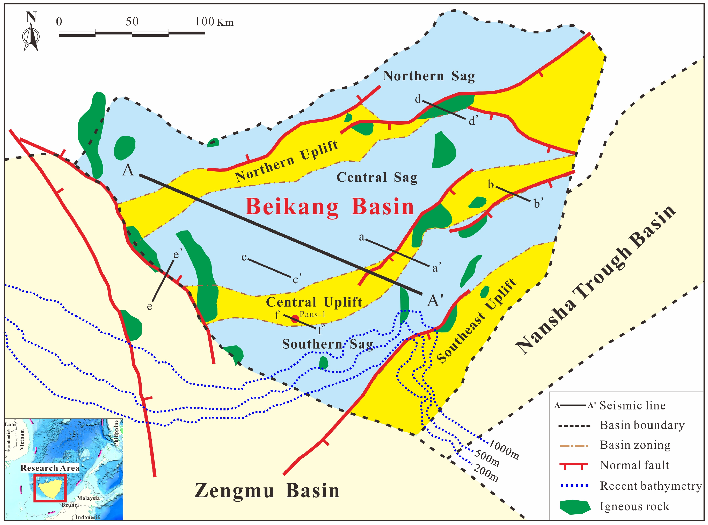
The Beikang Basin, located in the southwestern South China Sea, is a large Cenozoic sedimentary basin [
9,
10,
11,
12,
13,
14,
15]. Structurally, it is subdivided into six second-order tectonic units: the Southeast Uplift, Central Uplift, Northern Uplift, Southern Sag, Central Sag, and Northern Sag (
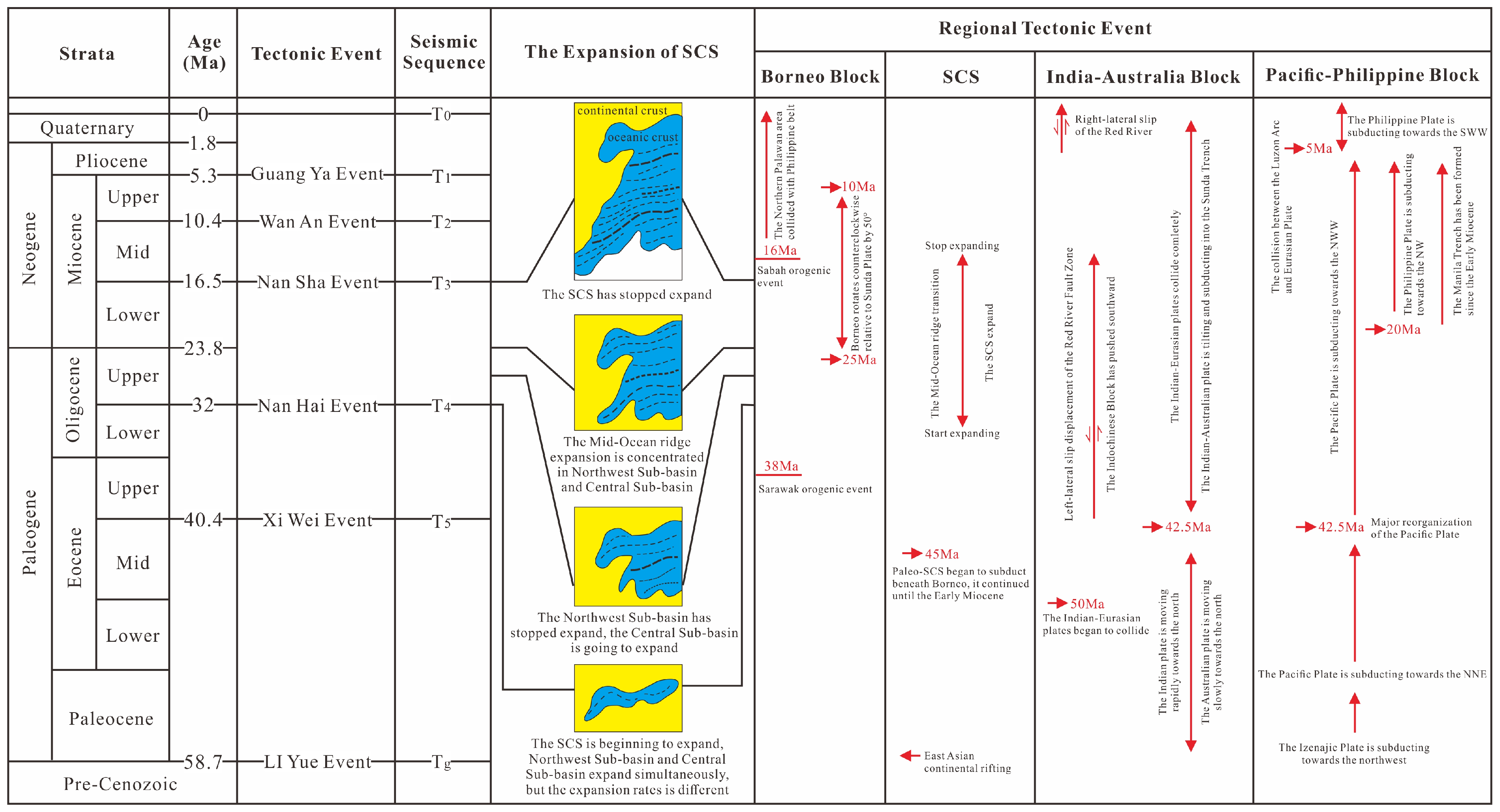
Figure 2). The Cenozoic succession comprises six main tectono-stratigraphic intervals (
Figure 3), including the Paleocene-middle Eocene (T
g–T
5), upper Eocene–lower Oligocene (T
5–T
4), upper Oligocene–lower Miocene (T
4–T
3), middle Miocene (T
3–T
2), upper Miocene (T
2–T
1), and Pliocene–Quaternary (T
1–T
0) [
16,
17,
18,
19]. The total thickness of the Cenozoic strata ranges from approximately 1 km to 12 km, with the thickest stratum observed near the shelf-slope break. Overall, the succession thickens southwestward toward the basin depocenters and thins northeastward toward the continental slope [
20,
21,
22,
23,
24]. Similar to many basins along the southern SCS margin, the Beikang Basin exhibits a two-tier “lower-rift/upper-sag” architecture. Bounded by two major regional unconformities T
g at the base of the Cenozoic and T
3 near the middle Miocene, the basin fill can be divided into a syn-rift stage and an overlying post-rift (sag) stage. The syn-rift stage includes an initial rift, an inherited extensional rift, and a climax-rift phase, whereas the post-rift stage comprises an initial sag, a compressional fault-sag, a relaxation sag, and a renewed compressional sag [
14,
25,
26,
27,
28,
29,
30].
Detailed interpretation of 2-D seismic profiles has defined the major Cenozoic sequence boundaries and clarified their geological significance. Two regionally angular unconformities—T
g and T
3—are identified as first-order sequence boundaries [
20,
21,
22] and traced across the entire basin, while four intervening disconformities—T
5, T
4, T
2, and T
1-are recognized as second-order sequence boundaries [
31,
32,
33,
34] (
Figure 3). From bottom to top, these surfaces correspond broadly to the Liyue, Xiwei, Nanhai, and Nansha tectonic events, respectively (
Figure 3).
T
g marks the base of the Cenozoic succession and is widely interpreted as the initial breakup unconformity (IU horizon) [
31,
32,
33]. On seismic profiles, it is recognized as reflector truncation below, onlap above, and local angular discordance, with distinct reflection patterns across the surface. Because of the great burial depth, T
g may be difficult to trace locally. T
g separates the Paleocene and Eocene and is dated at ca. 58.7 Ma.
T
4 is commonly interpreted as the stratigraphic response to the onset of SCS seafloor spreading [
14]. Below T
4, reflections are medium- to low-frequency, high-amplitude, and laterally continuous but spatially restricted. Above T
4, reflections shift to more continuous, medium-to-high frequency and moderate-to-low amplitude with a much broader distribution. T
4 separates the lower and upper Oligocene and is dated at ca. 32 Ma.
T
3 is the most prominent basin-wide unconformity and represents the breakup or rift-to-sag transition surface. It has been termed or interpreted as the MMU (e.g., Hutchison (2010) [
33]), the SCSU surface (e.g., Cullen et al. (2010) [
21]), a collisional unconformity (e.g., Sun et al. (2011) [
22]), and an indicator of spreading cessation in the South China Sea (e.g., Yao et al. (2013) [
15]). Seismically, most major faults terminate upward against T
3. Above T
3, the succession consists of onlapping sag-fill with low-frequency, low-amplitude, continuous reflections, and only minor faulting. Below T
3, the section is characterized by rift-fill with truncation, high-amplitude, continuous reflections, and segmented half-graben geometries. T
3 separates the lower and middle Miocene and is dated at ca. 16.5 Ma.
3. Data and Methods
The 2-D seismic profiles used in this study were acquired by the Guangzhou Marine Geological Survey. The original surveys employed 60 receiver channels, 15-fold coverage, a 26 m group interval, a 53 m shot interval, and an air-gun source volume of 1500 cubic inches.
These data were collected in the 1990s when acquisition and processing technology was limited. As a result, the raw sections suffer from a low signal-to-noise ratio, short spreads, low fold, imprecise velocity analysis for the mid-to-deep sections, multiple types of coherent noise and multiples, blurred deep imaging, and loss of low-frequency energy. Such deficiencies hindered reliable fine-scale interpretation and limited the use of the original dataset for detailed tectono-stratigraphic studies.
To improve data quality, we reprocessed the seismic lines using a high-resolution imaging workflow designed to
The workflow included: adaptive low-frequency noise suppression, DWMP + SRME multiple attenuation, common-offset RNA for weak-signal recovery, and iterative migration-velocity analysis with high-precision velocity-model building by using Omega software suites 2018 [
3,
4,
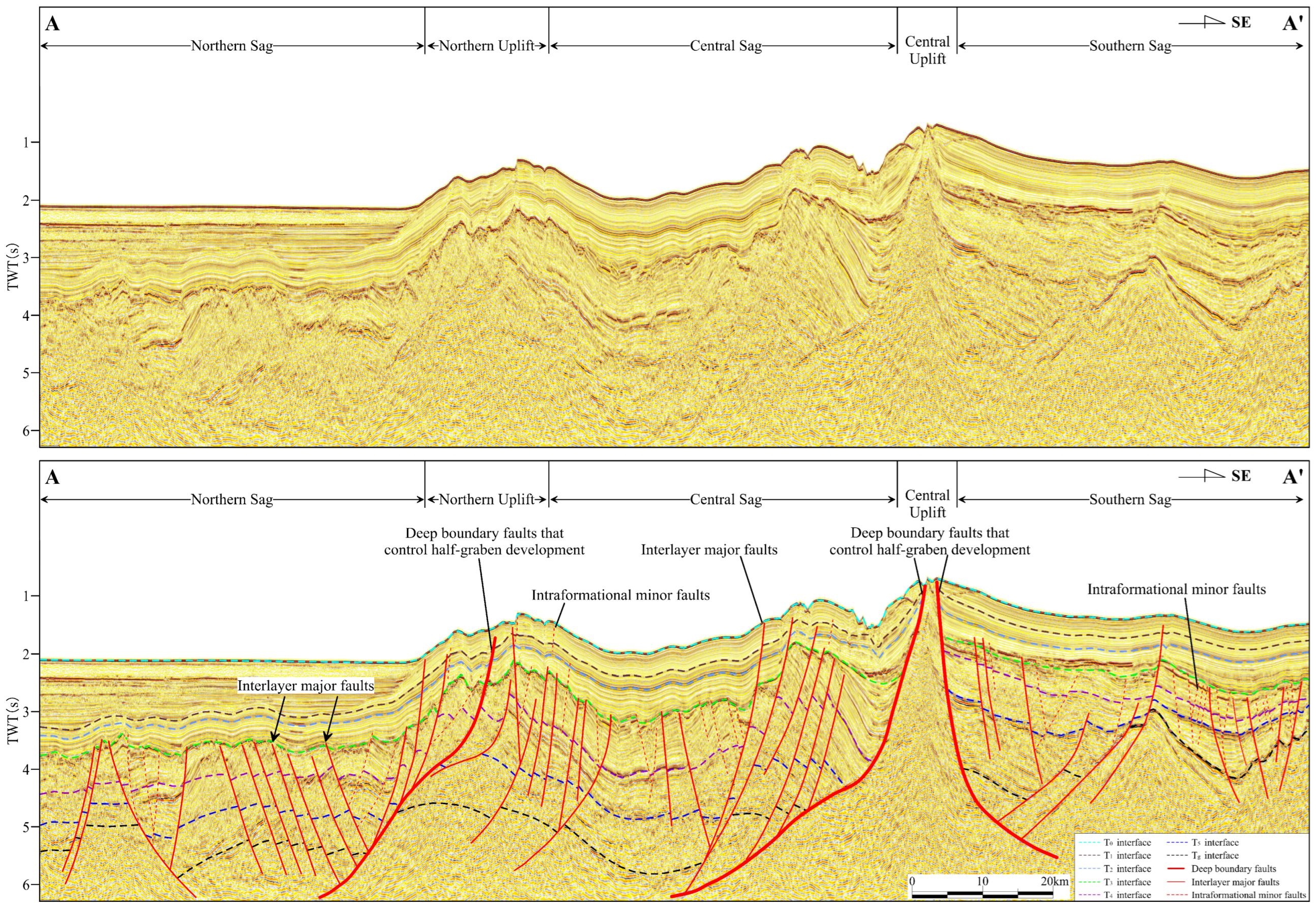
5]. These steps significantly improved the signal-to-noise ratio, imaging quality of faults and structural boundaries, and the resolution of stratigraphic architecture, as well as produced a well-imaged basin floor, particularly at mid-to-deep levels (
Figure 4).
Owing to the scarcity of well control, sequence boundaries were identified primarily from
Regional angular unconformities (e.g., Tg, T3).
Surfaces marking major shifts in depositional trends (e.g., T2).
Local angular unconformities combined with distinct changes in depositional style (e.g., T4 and T5).
Fault interpretation relied on
These criteria enabled consistent fault picking across all seismic lines and the construction of laterally coherent fault networks on time–structure maps.
We have implemented an integrated seismic–facies, seismic–lithofacies, and depositional–facies workflow. This approach improves lithofacies discrimination and, when combined with interpretations of depositional settings and paleo-drainage systems, allows a more robust restoration of the basin’s sedimentary systems.
4. Results
4.1. Fault Characteristics of the Beikang Basin
The T3 unconformity divides the Beikang Basin into a syn-rift stage (Tg–T3) and a post-rift stage (T3–T0), each with distinctly different faulting styles.
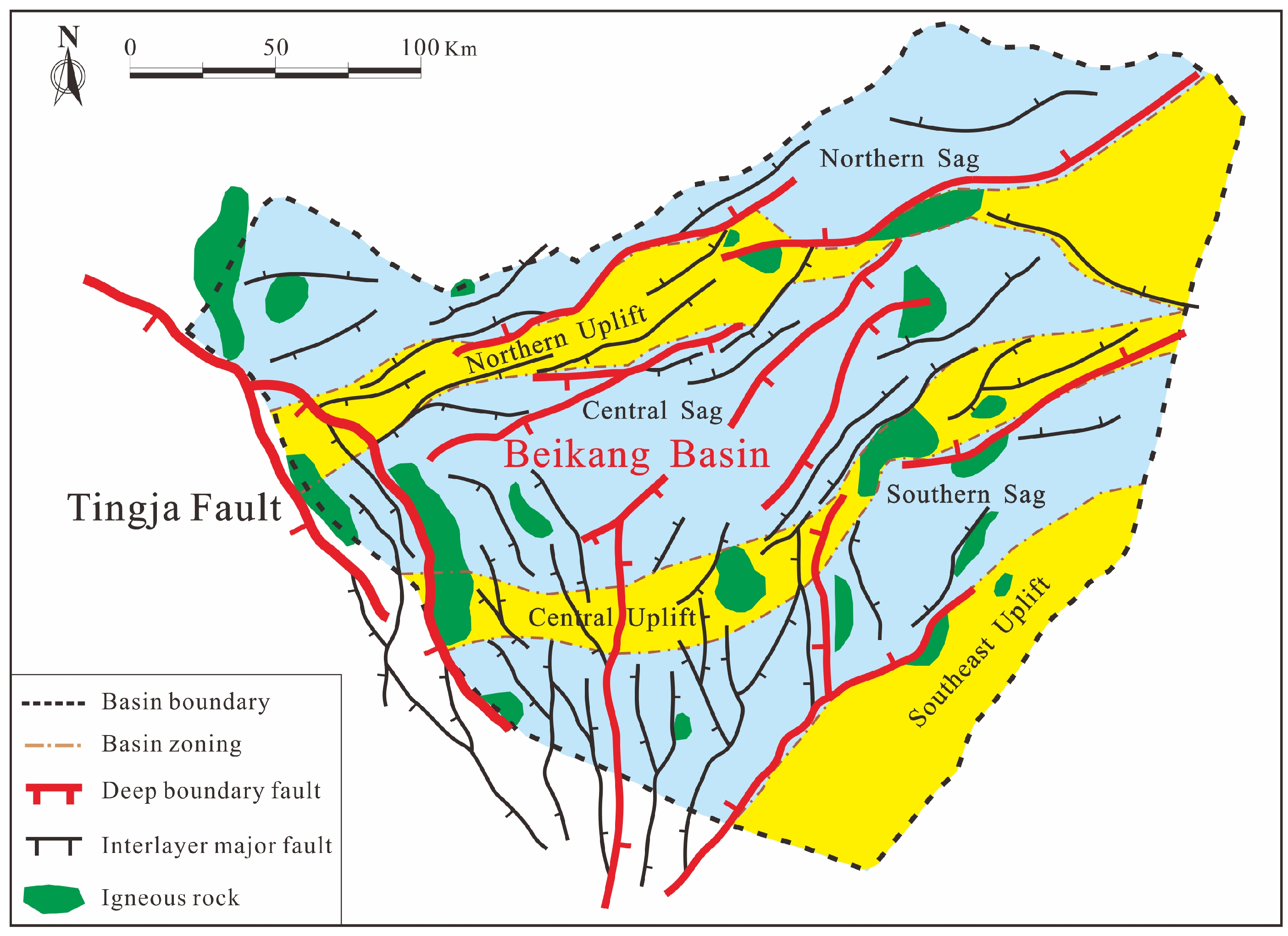
The syn-rift stage represents the principal episode of faulting in the basin. Dominated normal fault development controlled the basin’s structural framework and subsidence patterns. The fault map at the T
g horizon (
Figure 5) shows that NE- to ENE-striking faults are most abundant, concentrated mainly in the north-central and eastern parts of the basin, and shows a wide range of scales. A major NW-striking fault, the Tingja Fault, traverses the western basin, with medium- to small-scale faults distributed around it forming an en-echelon array [
25,
35,
36,
37,
38]. They were interpreted as the product of dextral strike-slip motion along the Tingja Fault. Sub-meridional faults occur in the south-central and southeastern areas, although they are fewer and smaller. According to their control on rifting, two fault categories are recognized:
Basin-bounding (boundary-master) faults (
Figure 6): Large, long-lived early rift-margin faults with substantial throws and strong structural inheritance. Most are syn-sedimentary listric faults that controlled depocenter localization and subsidence pattern during the syn-rift stage [
39,
40,
41,
42,
43];
Inter-layer major faults (
Figure 6): Faults that offset two or more stratigraphic packages, typical planar with moderate to large throws and limited inheritance. They exerted little syn-depositional control, show variable timing, and most terminate upward at the T
3 unconformity.
During the post-rift sag stage, fault activity waned. Structures are still dominated by normal faults, but are generally of smaller scale. Their orientations and spatial distribution resemble those of the syn-rift stage, but their throws are markedly reduced. On seismic profiles, only the basin-bounding faults cut through the T
3 unconformity into younger units, whereas most deformation is expressed by intraformational faults minor faults that exert only limited disruption of the sag succession (
Figure 6).
4.2. Typical Structural Styles in the Basin
Based on interpretation of 2-D seismic data, five structural styles were identified in the Beikang Basin: extensional, compressional-inversion, strike-slip–extensional, magmatic, and diapiric. The first three are fault-related, while the last two are mainly controlled by the volcanic phases and only in a subordinate way, by the faulting.
4.2.1. Extensional Structural Styles
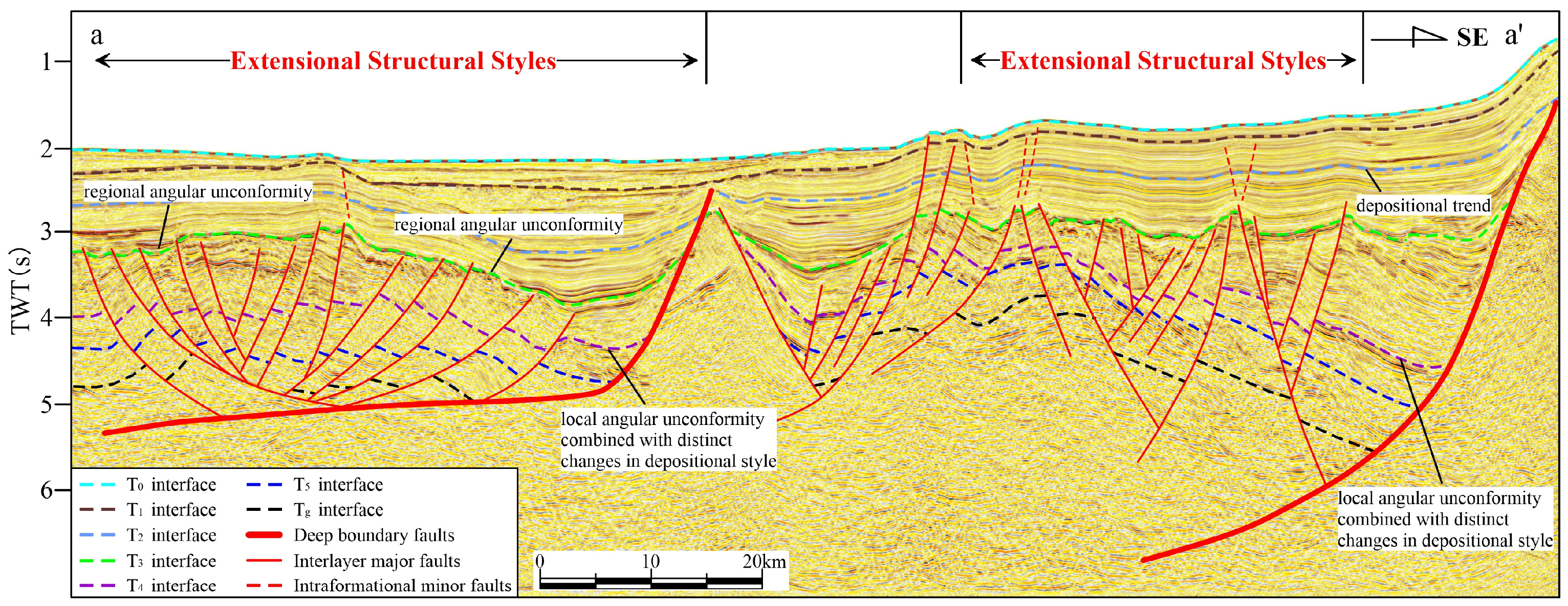
This is the most widespread structural style in the basin (
Figure 7). It is characterized by basin-bounding faults and associated synthetic or antithetic faults commonly showing planar or listric geometries, with rare ramp-flat geometries [
44,
45,
46]. Dominantly NE- to ENE-striking, these extensional faults controlled the development of the early half-graben architecture. In the hanging walls, rollover anticlines and tilted fault blocks are common, forming typical extensional–rollover–anticline and extensional–tilted-block structural traps.
Affected by both the opening of the modern SCS and subduction of the Paleo-SCS beneath Borneo, faults dip, steepen, and deepen toward the southeastern basin margin, whereas to the northwest they tend to flatten and sole out at progressively shallower levels.
4.2.2. Compressional-Inversion Structural Style
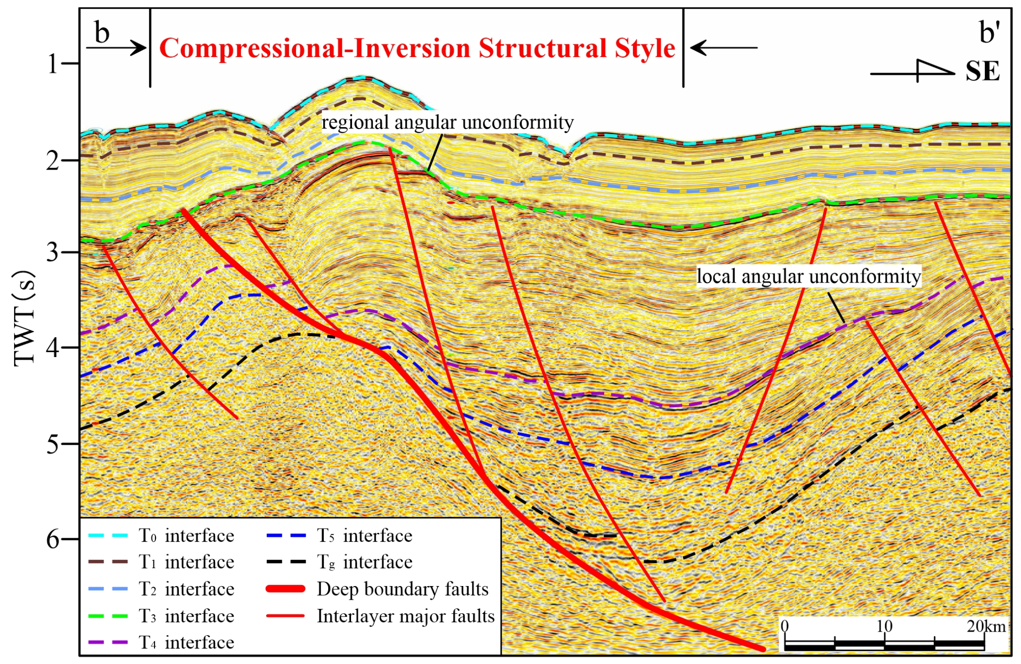
Cullen et al. [
21] documented inversion structures within the Beikang Basin (
Figure 8) that likewise resulted from the collision between the Beikang and Zengmu Basins. Selective reactivation of pre-existing extensional faults under later compressional stress produced these structures. Because the magnitude of compression was modest, most faults retained their normal sense of slip and did not invert to thrusts. Deformation is shown primarily as compressional folds rather than reverse faulting [
46,
47,
48]. On seismic profiles, these structures exhibit a characteristic “sag-below, bulge-above” geometry: strata below horizon T
4 show concave-downward flexures frim extensional faulting, whereas the overlying section displays convex-upward folds generated by later compression. Notably, T
4 (ca. 32 Ma) is approximately coeval with the onset of modern SCS seafloor spreading, which explains the preferential development of compressional-inversion structures near this stratigraphic level within the Beikang Basin.
4.2.3. Strike-Slip–Extensional Structural Style
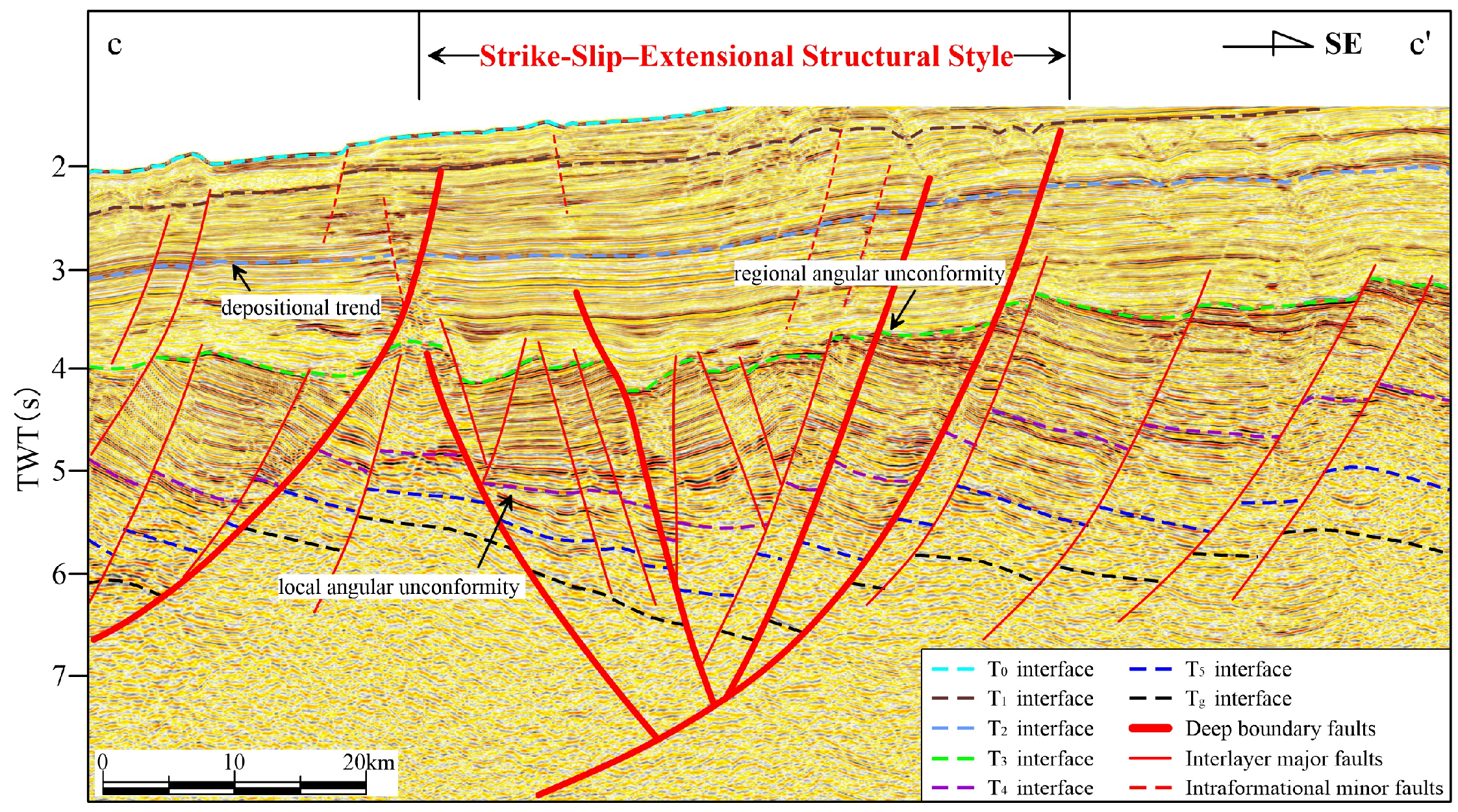
This structural style is best developed along the boundary between the Beikang and Zengmu basin, strongly influenced by the Tingjia Fault [
32,
34,
35]. Two generations of steeply dipping strike-slip–extensional faults are recognized (
Figure 9). The first generation, predating T
3, controlled the formation of small local grabens. It is characterized by prominent large-scale negative flower structures with symmetrical fault arrays fanning upward and converging downward. The second generation, post-dating T
2, is associated with the basin bounding master fault that controlled sag-stage subsidence and produced smaller-scale negative flower structures.
4.2.4. Magmatic Structural Style
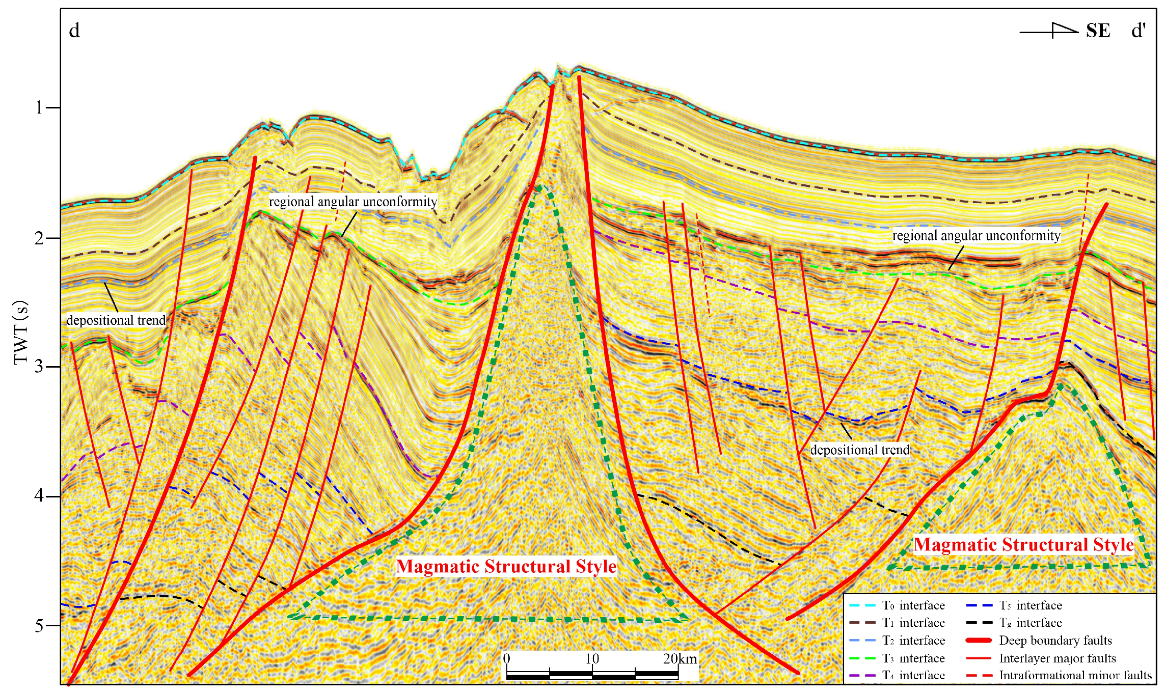
This style encompasses both volcanic eruptions and magmatic intrusions (
Figure 10). Both are spatially associated with major faults—particularly the deep-seated, basin-bounding faults—and commonly display piercement–drag geometries. Volcanic activity produced volcanic cones, whereas magmatic intrusions led to domal uplifts capped by crestal grabens.
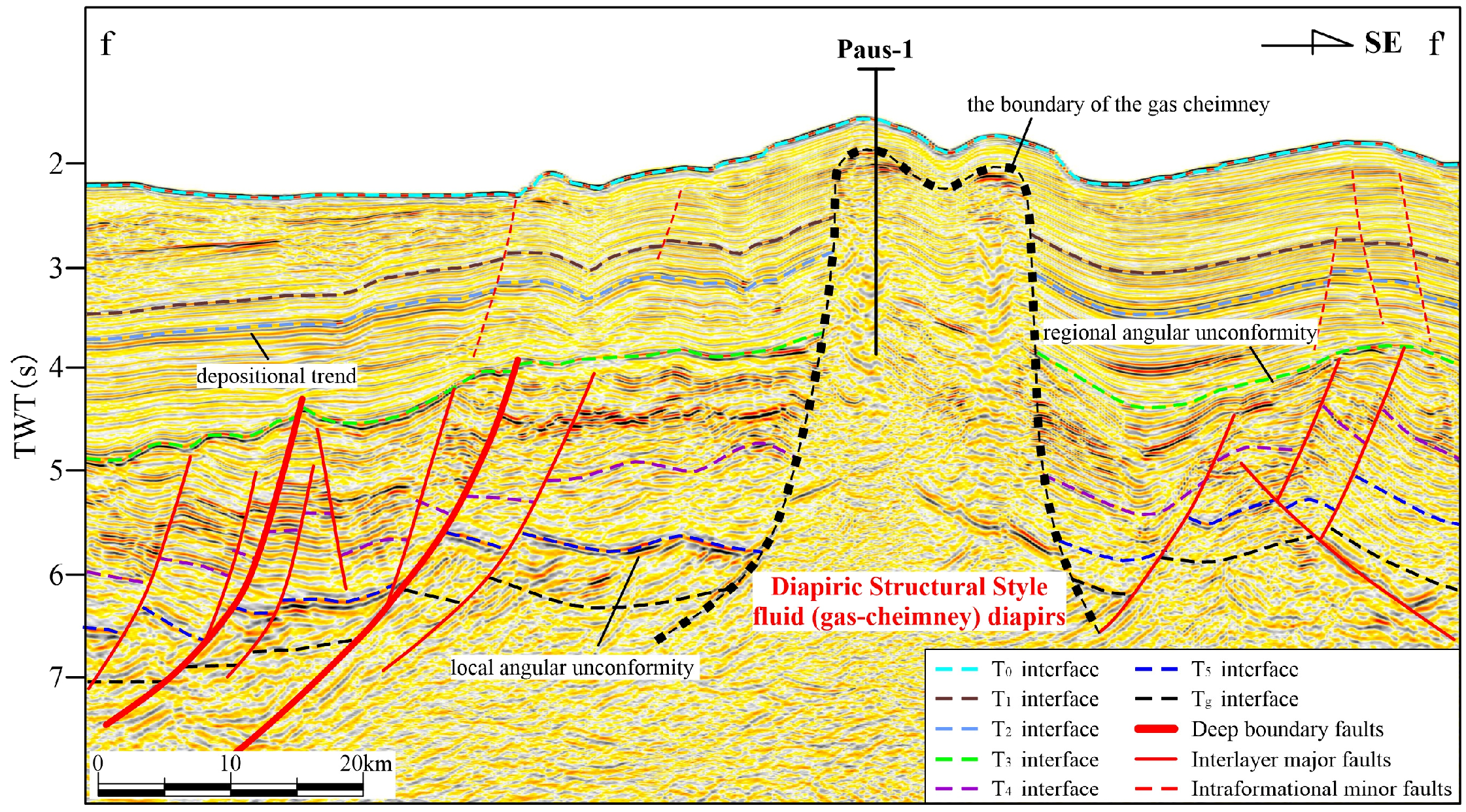
4.2.5. Diapiric Structural Style
This style is fluid diapirs (
Figure 11) that are shown as gas cheimney. In seismic profiles, they are marked by chaotic to dim reflection zones, downward-dragged strata within the cheimney, and bright-spot anomalies at their tops. The occurrence of these features was confirmed by drilling data from the Paus-1 well [
49,
50,
51].
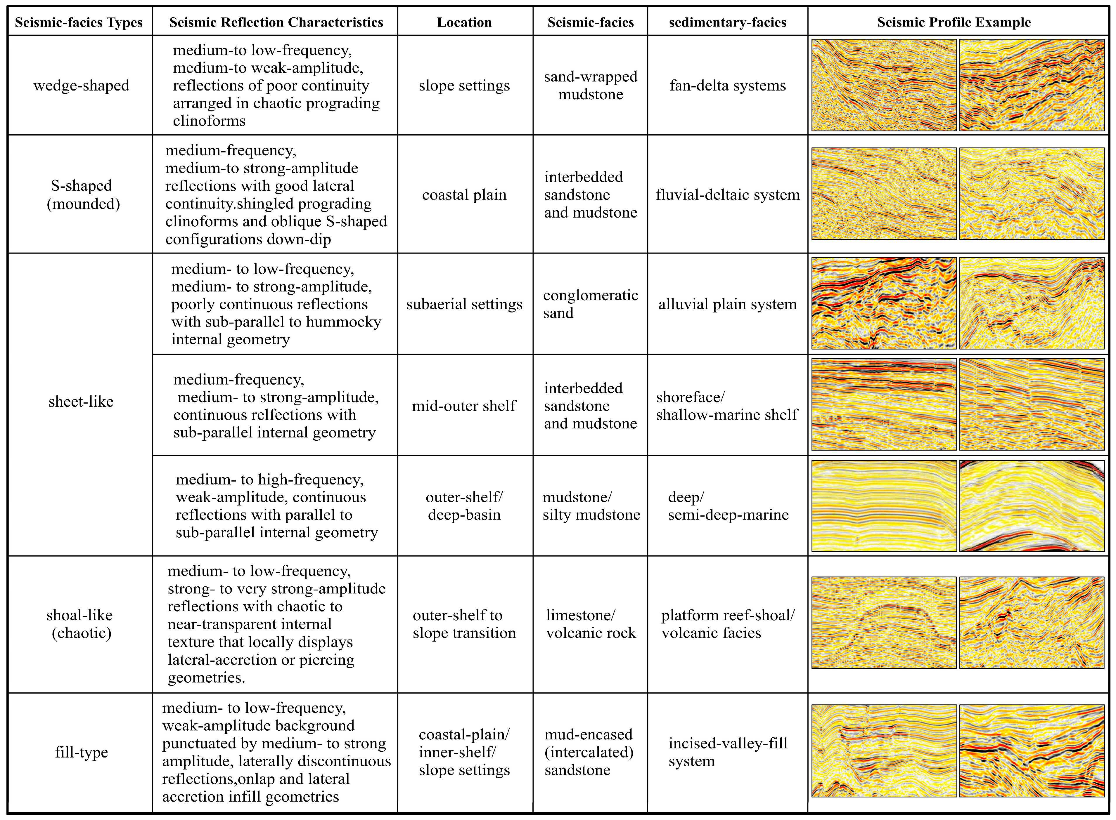
4.3. Characteristics of Seismic and Depositional Facies
Five major seismic facies types are identified in Beikang Basin based on reflection pattern and geometry, including wedge-shaped, S-shaped (mounded), sheet-like, shoal-like (chaotic), and fill-type [
52,
53,
54,
55]. These seismic facies correspond to seven seismic lithofacies including conglomerate–sandstone, sandstone-dominated with mudstone interbeds, interbedded sandstone–mudstone, mudstone-dominated with sandstone interbeds, mudstone, and volcanic rocks [
52,
53,
54,
55]. Together they define eight primary depositional facies including fan delta, fluvial delta, alluvial plain, coastal–shallow marine, and others (
Figure 12).
4.3.1. Wedge-Shaped Seismic Facies
On seismic profiles, this facies appears with medium to low frequency and medium-to-weak-amplitude reflections of poor continuity arranged in chaotic prograding clinoforms. It typically occurs on slope settings or on the down-thrown side of major faults. The medium to low frequency indicates high sedimentation rates and substantial bed thickness, whereas the weak amplitude generally reflects low acoustic-impedance contrast. Local medium-amplitude events develop where sandstone–mudstone contacts are more pronounced. The low continuity suggests lenticular sand-body geometry. Lithologically, the facies is interpreted to be sandstone-dominated with mudstone interbeds (sand-wrapped mudstone), with a likely depositional setting of fan delta systems.
4.3.2. Mounded (S-Shaped) Seismic Facies
Seismically, this facies is characterized by medium-frequency, medium-to-strong-amplitude reflections with good lateral continuity. Internally, it displays shingled prograding clinoforms and oblique S-shaped configurations down-dip, whereas in the strike view it appears as low-relief mounds on coastal-plain settings. The medium frequency indicates moderate sedimentation rates and intermediate bed thicknesses. The medium-to-strong amplitudes indicate pronounced impedance contrast at sandstone–mudstone contacts. The high continuity reflects stable and widespread depositional conditions. This facies is interpreted to be interbedded sandstone and mudstone deposited within a fluvial-deltaic system.
4.3.3. Sheet-like Seismic Facies
This facies have three main variants that are recognized in the Beikang Basin:
The first displays medium-to-low-frequency, medium-to-strong-amplitude, poorly continuous reflections sub-parallel to hummocky internal geometry in seismic character. It is commonly adjacent to wedge-shaped facies in subaerial settings and inferred to correspond to a conglomerate–sandstone lithofacies deposited in an alluvial plain setting.
The second is characterized on seismic sections by medium-frequency, medium-to strong-amplitude, continuous reflections with sub-parallel internal geometry developed on the mid to outer shelf. The moderate frequency indicates a lower accumulation rate than the wedge facies; the moderate-to-strong amplitude points to sand/mud interfaces with an impedance contrast; and the good continuity suggests a stable, widespread depositional environment. It is interpreted as an interbedded sandstone–mudstone lithofacies deposited in a shoreface to shallow-marine shelf.
The third exhibits medium-to-high-frequency, weak-amplitude, continuous reflections with parallel to sub-parallel internal geometry found on the outer shelf to deep-basin floor. The moderate-to-high frequency implies a low sedimentation rate, the weak amplitude reflects small internal impedance contrasts, and the continuous reflections indicate a stable, extensive depositional regime. It is inferred to be a quiet-water mudstone (shale) or silty mudstone lithofacies deposited in a deep-to-semi-deep-marine setting.
4.3.4. Chaotic Seismic Facies
This facies occurs mainly across the outer-shelf-to-slope transition. It is characterized by medium-to-low-frequency, strong-to-very-strong-amplitude reflections with chaotic to near-transparent internal texture that locally displays lateral-accretion or piercing geometries. The medium to low frequency indicates relatively rapid deposition, whereas the strong to very strong amplitudes reflect the presence of calcareous, carbonate-rich, or volcaniclastic material. The lithofacies is accordingly interpreted to be volcanic rocks including lava flows, volcaniclastic deposits, and intrusive bodies. Lava flows appear as continuous, extremely high-amplitude reflections. Volcaniclastic drapes or fallout near vents form mounded, rootless lobes with poor structural continuity along their flanks. Intrusive bodies display a clear feeder “root” and induce domal uplift and deformation along their margins.
4.3.5. Fill-Type Seismic Facies
This facies is expressed by a medium-to-low-frequency, weak-amplitude background punctuated by medium-to-strong-amplitude, laterally discontinuous reflections. Internally, it displays onlap and lateral-accretion infill geometries and occurs in coastal-plain, inner-shelf, and slope settings. The medium to low frequency indicates high sedimentation rates and substantial fill thickness, whereas the weak background reflects encasing mudstone packages. The medium-to-strong-amplitude internal reflections indicate significant impedance contrasts within the channel fills. The low continuity suggests short-axial, sand-rich channel bodies. Lithofacies is interpreted to be mud-encased (intercalated) sandstone deposited within an incised-valley-fill system.
5. Discussion
5.1. Tectonic Evolution of the Beikang Basin
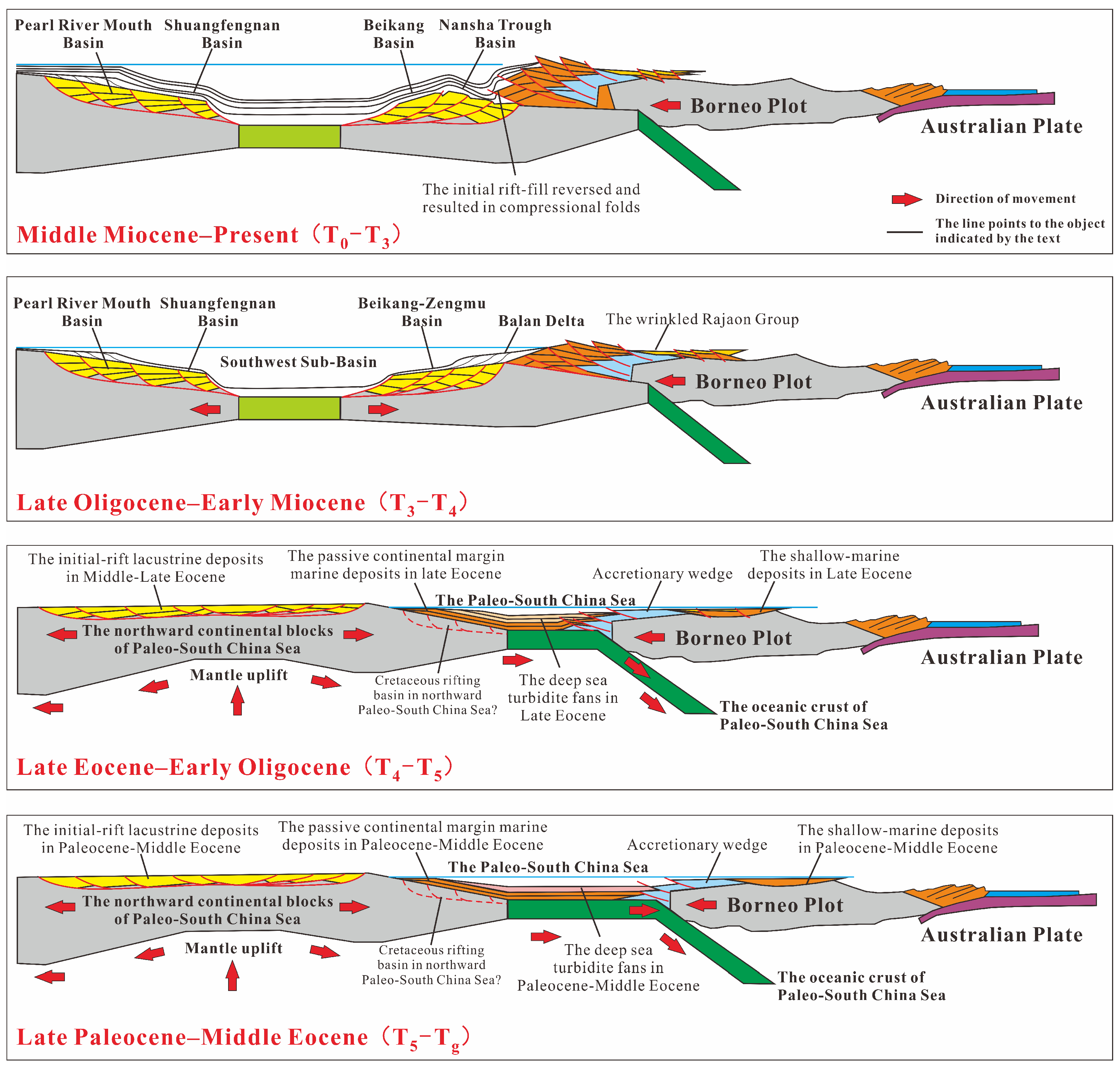
The tectonic evolution of the Beikang Basin was largely controlled by the regional dynamics of Neo-South China Sea seafloor spreading combined with the subduction-drag effect of the Paleo-South China Sea. Four successive stages are recognized [
26,
27,
28,
29,
34,
35,
36,
37,
38] (
Figure 13) including late Paleocene–middle Eocene (T
g–T
5) initial rifting, late Eocene–early Oligocene (T
5–T
4) inherited extensional rifting, late Oligocene–early Miocene (T
4–T
3) climax rifting, and middle Miocene–present (T
3–T
0) regional post-rifting subsidence.
5.1.1. Initial Rifting Stage (Late Paleocene–Middle Eocene)
During this earliest stage, the basin lay along the northern margin of the Paleo-South China Sea and began to undergo NW-SE-directed extension. A series of NE-ENE-trending half-grabens or grabens developed, typified by northwest-onlap, southeast-throw, spoon-shaped half-graben structures that created several strongly compartmentalized depocenters. Except for the southeastern margin that was open to the Paleo-South China Sea, most of the basin remained in a continental lacustrine setting [
34,
37,
38,
39].
5.1.2. Inherited Extensional Rift Stage (Late Eocene–Early Oligocene)
Driven by the Xiwei tectonic event and the onset of seafloor spreading in the Southwest sub-basin of the South China Sea, the Beikang Basin drifted southward while a global eustatic rise triggered a major transgression. Pre-existing extensional faults were reactivated and intensified, still affecting local sedimentation. The earlier horst-and-graben framework evolved into a single, integrated depocenter as sedimentation expanded beyond individual half-grabens [
13,
14,
22,
23,
24,
27].
5.1.3. Climax-Rift Stage (Late Oligocene–Early Miocene)
As the South China Sea underwent east-to-west progressive seafloor spreading [
23,
24,
25,
26], the Nansha Block was separated from the South China continental margin and drifted farther south, leading to further basin subsidence and deepening. The Early Miocene Sabah orogeny generated intense regional deformation across the Nansha area, and had a strong impact on the Beikang Basin. This orogenic pulse reactivated dextral strike-slip motion along the Tingja Fault, subjecting the western depression and central uplift to strong transtensional–transpressional deformation. A new set of NW-striking en-echelon faults overprinted and locally offset the pre-existing NE-trending system, effectively terminating rift-stage tectonism and establishing the basin’s present-day structural framework [
13,
14,
22,
23,
24,
27].
5.1.4. Regional Subsidence Stage (Middle Miocene–Present)
Since the middle Miocene, regional compression combined with post-spreading thermal subsidence significantly reduced fault activity. As such, faults ceased to exert significant influence on sedimentation, although magmatism persisted locally. Starting from the late Miocene, accelerated subsidence along the South China Sea continental margin drowned the basin floor, shifting the Beikang Basin progressively into bathyal to abyssal environments [
13,
14,
22,
23,
24].
5.2. Sedimentary Evolution of the Beikang Basin
Based on the seismic-facies and depositional-facies interpretations, we reconstructed the sedimentary evolution to include four main stages that correspond closely to the tectonic history: initial rift-fill, inherited–extensional rift-fill, climax rift-fill, and post-rift sag-fill [
12,
13,
22,
23,
24,
27].
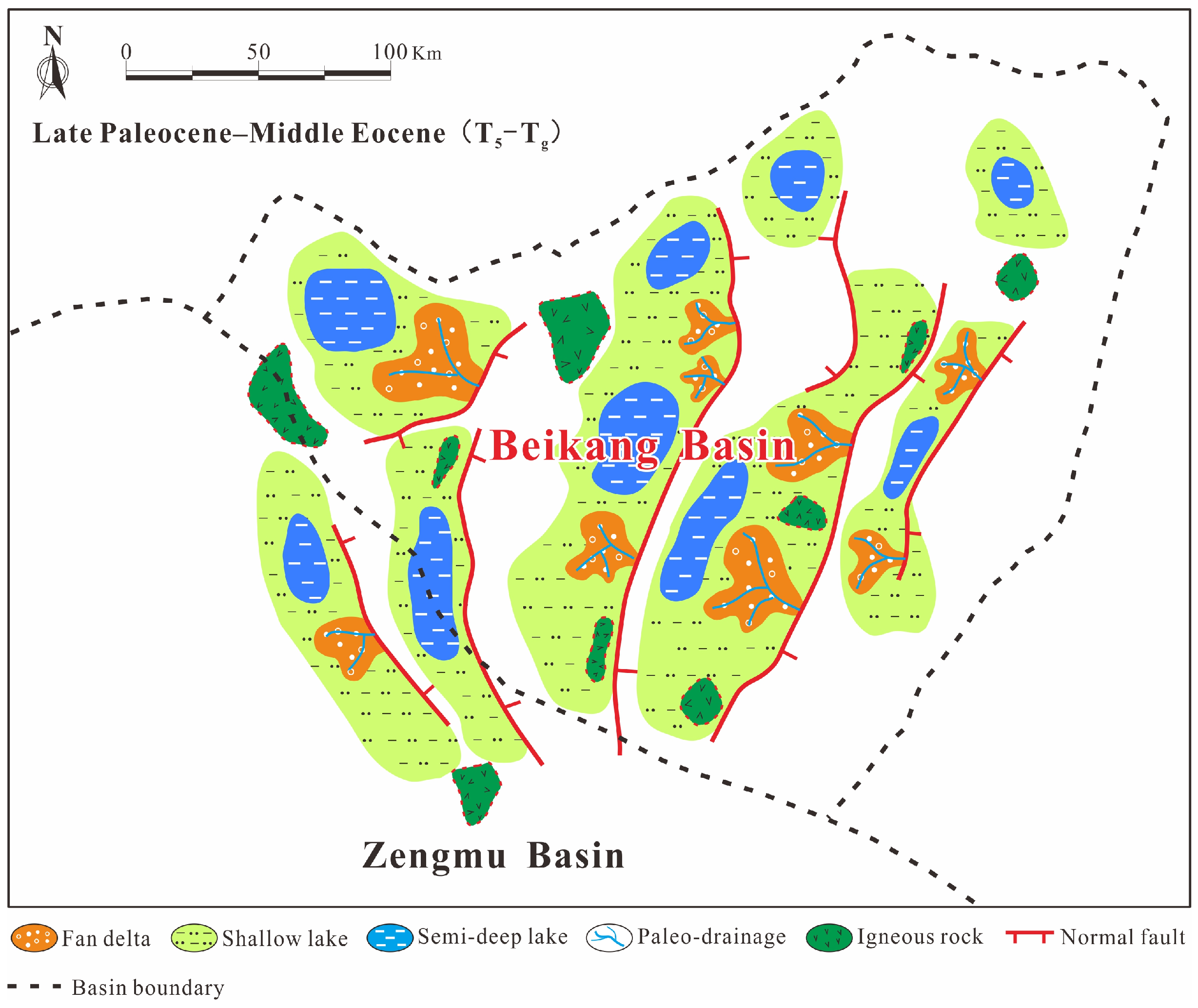
5.2.1. Initial Rift Depositional Stage (Late Paleocene–Middle Eocene)
The basin consisted of a suite of isolated half-grabens controlled by extensional faults. Four large, relatively deep depocenters developed mainly within the Central and Southern depressions. Sediment was supplied almost exclusively from footwall-derived catchments immediately adjacent to the master faults, producing nearshore subaqueous fans, alluvial fan complexes, and fan delta deposits dominated by coarse clastics in fluvial–lacustrine settings [
52,
53,
54]. No exploration wells have yet penetrated this succession, and no correlative outcrops have been identified onshore in the southern Zengmu Basin (
Figure 14).
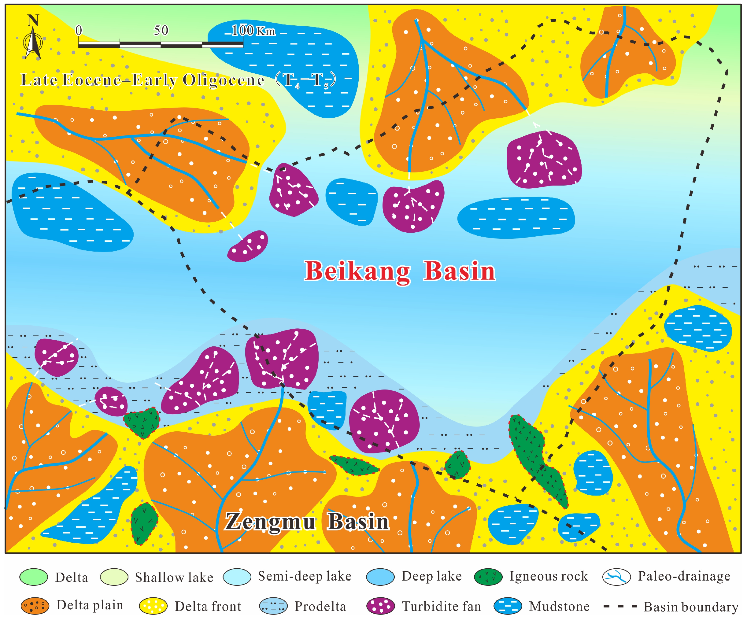
5.2.2. Inherited Extensional Rift Depositional Stage (Late Eocene–Early Oligocene)
This interval documents the rift-to-sag transition in the basin. Depositional environments evolved from continental lacustrine to shallow-lacustrine, and then to transitional marine settings. Sediment supplied by the proto-Rajang and proto-Baram rivers prograded toward the basin center, but largely remained confined to the southern margin. In contrast, the northern margin experienced shoreline retreat, leaving only localized turbidite fans in the Northern Depression. Volcanic activity persisted in the southern Beikang Basin, building volcanic cones adjacent to vents [
53,
54,
55]. No wells have yet penetrated this interval and regional correlation with the northern Pearl River Mouth Basin indicates equivalence to the Enping Formation (
Figure 15).
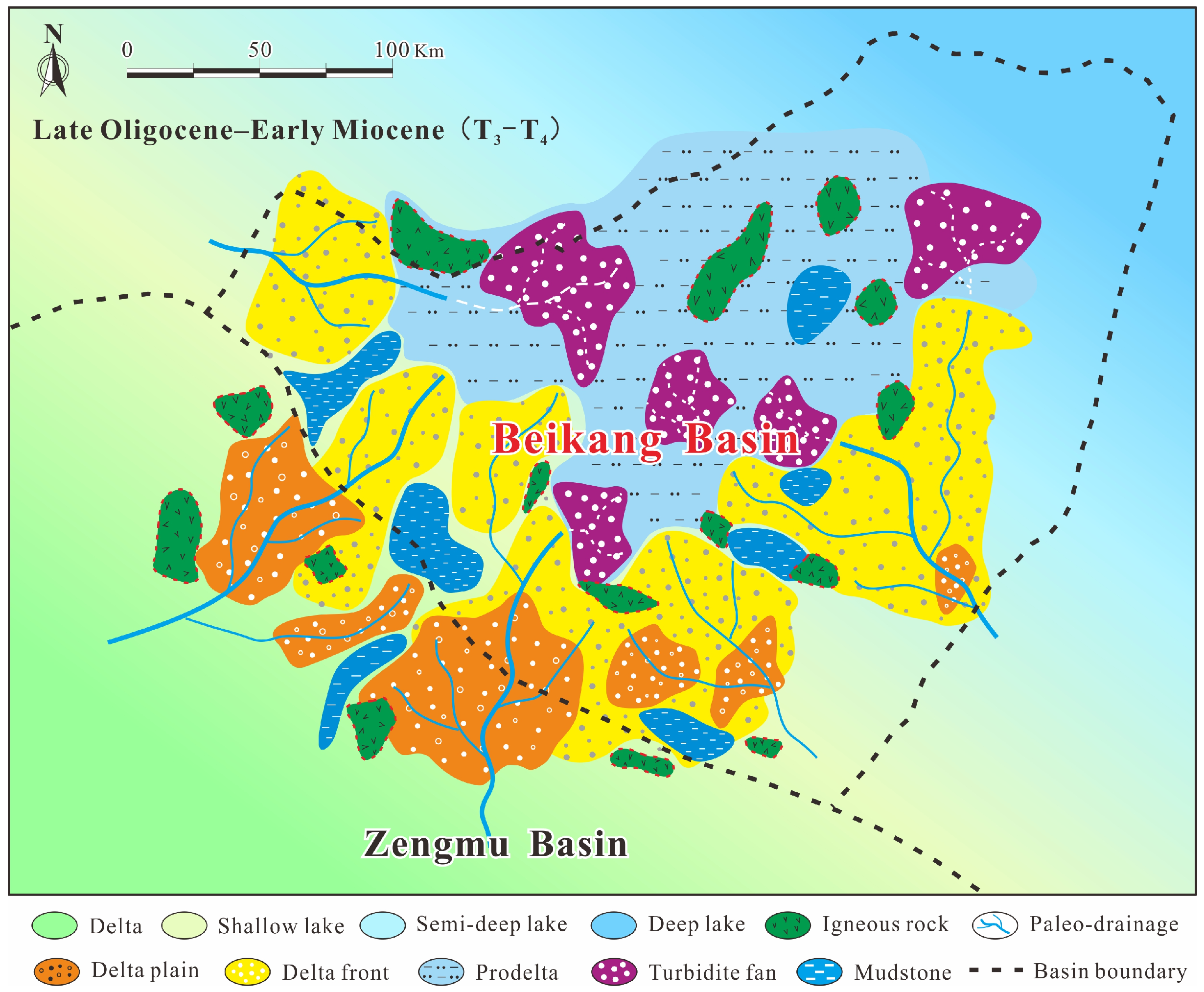
5.2.3. Climax Rift Depositional Stage (Late Oligocene–Early Miocene)
As the basin progressively collided with Borneo, the new South China Sea began to open while the Paleo-South China Sea vanished, producing a major marine transgression that flooded the basin and merged previously isolated half-grabens into a broad, connected seaway. In the southern basin, sediment supply shifted almost entirely to the Borneo hinterland, feeding a large shelf-margin delta system that prograded basinward into deep-water fan systems. In the north, sediment provenance shifted to the Indochina Peninsula, delivering coeval but compositionally distinct clastics [
53,
54,
55]. The succession is dominated by coastal-plain sand–mud packages with interbedded coals, overlain by shallow-marine sandstones and mudstones (
Figure 16). Some wells demonstrate that the coastal-plain coal measures and shallow-marine mudstones act as major hydrocarbon source rocks, whereas the coastal-plain and shallow-marine sandstones serve as principal reservoirs.
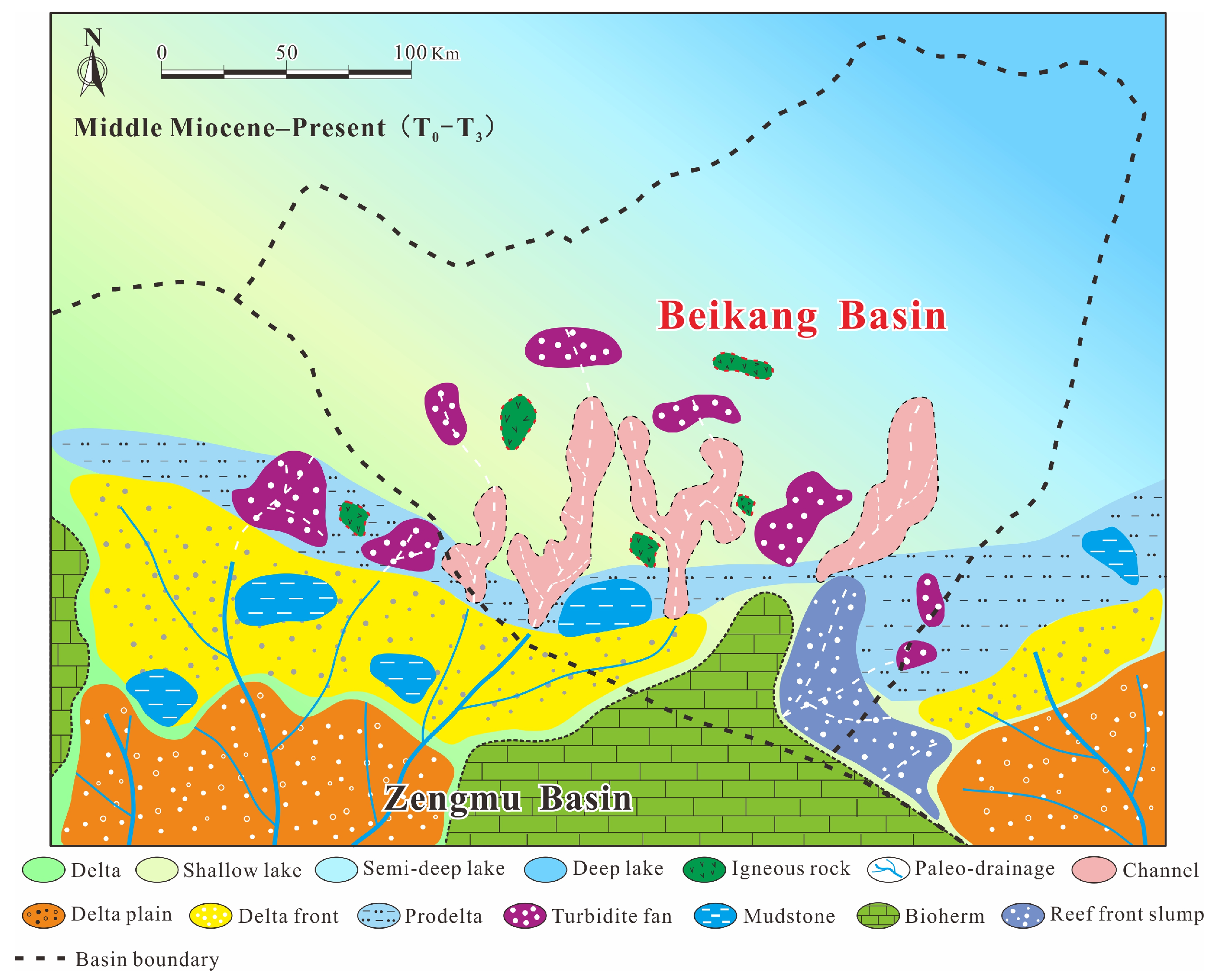
5.2.4. Post-Rift Sag Depositional Evolution (Middle Miocene–Present)
Thermal subsidence dominated the basin development and triggered a major transgression during this stage. Southern sediment sources retreated landward to the shelf, leaving only channel-fed turbidite fans on the slope and in the deep basin. From the Nankang Terrace to the southeastern uplift, patchy but widespread carbonate bioherms developed, accompanied by reef-front slumps in the south. Source rocks are generally absent in this interval [
55]. Delta-front sands become finer-grained with poorer reservoir quality, and distal fringes grade into bathyal–abyssal deposits. The carbonate bioherms form the principle reservoirs, although their overall scale remained limited. After the Pliocene, increasing terrigenous clastic influx blanketed and ultimately terminated reef growth (
Figure 17).
6. Conclusions
Through regional correlation and seismic interpretation, six key reflectors—Tg, T5, T4, T3, T2, and T1—are identified across the Beikang Basin. Tg and T3 are first-order sequence boundaries with basin-wide expression: Tg marks the base of the Cenozoic succession, whereas T3 corresponds to the breakup unconformity and rift-to-sag transition surface. T5, T4, T2, and T1 are second-order sequence boundaries, with T4 recording the stratigraphic response to the South China Sea seafloor spreading.
Faults in the Beikang Basin can be grouped into three main classes: (1) deep-seated basin-bounding faults that control syn-rift subsidence, (2) major inter-stratal faults, and (3) minor intra-stratal faults. These faults formed mainly during the rift stage, trend NE to ENE, and together define five principal structural styles including extension, compression-inversion, strike-slip-extension, magmatic, and diapiric, of which the extensional style is most widespread.
The tectonic evolution of the Beikang Basin can be divided into four successive stages, including (1) initial rifting (late Paleocene–middle Eocene), (2) inherited extensional rifting (late Eocene–early Oligocene), (3) climax rifting (late Oligocene–early Miocene), and (4) regional post–rift subsidence (middle Miocene–present).
Influenced by tectonics, the sedimentary evolution of the Beikang Basin also experienced four stages: initial-rift deposition, inherited–extensional rift deposition, climax-rift deposition, and post-rift thermal-sag deposition.
In Beikang Basin, late Eocene–early Oligocene mudstones constitute effective source rocks, while late Oligocene–early Miocene deltaic and turbidite-fan sandstones form high-quality reservoirs. Extensional and strike-slip–extensional structural styles host a variety of fracture types that act as vertical migration pathways, allowing hydrocarbons generated in deeper source intervals to charge structurally higher reservoirs and accumulate into robust traps.
Author Contributions
Conceptualization, S.L., L.Z. (Lifu Zhang) and K.Z.; methodology, X.W. and G.H.; writing—original draft, S.L., X.W. and L.Z. (Lifu Zhang); writing—review and editing, G.H. and Q.Y.; supervision, L.Z. (Li Zhang). All authors have read and agreed to the published version of the manuscript.
Funding
This research was supported by the Project of China Geology Survey (DD20221708), the Hainan Province Science and Technology Special Fund (ZDYF2025GXJS013), and the National Natural Science Foundation of China (42130408).
Data Availability Statement
All the data and materials used in this paper are available from the corresponding authors upon request.
Conflicts of Interest
Lifu Zhang was employed by Sinopec Southwest Oil and Gas Company. The authors declare that the research was conducted in the absence of any commercial or financial relationships that could be construed as a potential conflict of interest.
References
- Taylor, B.; Hayes, D.E. The tectonic evolution of the South China Basin. In The Tectonic and Geologic Evolution of Southeast Asian Seas and Islands; Geophysical Monograph Series; American Geophysical Union: Washington, DC, USA, 1980; Volume 23, pp. 89–104. [Google Scholar]
- Tapponnier, P. On the mechanics of the collision between India and Asia. Geol. Soc. Lond. Spec. Publ. 1986, 19, 115–157. [Google Scholar] [CrossRef]
- Hamilton, W. Tectonics of the Indonesian Region; US Geological Survey Professional Paper; U.S. Government Publishing Office: Washington, DC, USA, 1979; pp. 345–1078.
- Liu, Z. Discussion on the Formation and Evolution of the South China Sea Basin. Mar. Sci. 1992, 4, 18–22. [Google Scholar]
- Holloway, N.H. North Palawak block, Philippines-Its relation to Asian mainland and role in evolution of South China sea. Am. Assoc. Pet. Geol. Bull. 1982, 66, 1355–1383. [Google Scholar]
- Michael, B.W.; Lars, O.; Lars, H. Geological development of the Central and South Vietnamese margin: Implications for the establishment of the South China Sea, Indochinese escape tectonics and Cenozoic volcanism. Tectonophysics 2009, 478, 184–214. [Google Scholar] [CrossRef]
- Peter, C.; Gwang, H.L.; Nguyan, A.D.; Udo, B.; Hoang, V.L.; Sun, Z. Seismic reflection evidence for a Dangerous Grounds miniplate: No extrusion origin for the South China Sea. Tectonics 2008, 27, 1–16. [Google Scholar] [CrossRef]
- Peter, L. A new view of integrating stratigraphic and tectonic analysis in South China Sea and north Borneo basins. J. Asian Earth Sci. 2019, 177, 220–239. [Google Scholar] [CrossRef]
- Morley, C.K.; Back, S.; Van Rensbergen, P.; Crevello, P.; Lambiase, J.J. Characteristics of repeated, detached, Miocene–Pliocene tectonic inversion events, in a large delta province on an active margin, Brunei Darussalam, Borneo. J. Struct. Geol. 2003, 25, 1147–1169. [Google Scholar] [CrossRef]
- Luo, S.; Zhang, L.; Xu, G.; Wang, X.; Lei, Z.; Shuai, Q. Reconstruction of Late Oligocene Depositional Systems in the Beikang Basin by Seismic Facies Analysis. Mar. Geol. Quat. Geol. 2022, 42, 123–134. [Google Scholar]
- Zhou, D.; Sun, Z.; Yang, S.; Lin, H. The stratigraphic system of the Zengmu Basin, Southern South China Sea. Earth Sci.—J. China Univ. Geosci. 2011, 36, 789–797. [Google Scholar]
- Franz, L.K.; John, J. The South China Sea: Sub-basins, Regional Unconformities and Uplift of the Peripheral Mountain Ranges since the Eocene. Ber. Sedimentol. 2016, 35, 5–54. [Google Scholar]
- Madon, M.; Kim, C.L.; Wong, R. The structure and stratigraphy of deepwater Sarawak, Malaysia: Implications for tectonic evolution. J. Asian Earth Sci. 2013, 76, 312–333. [Google Scholar] [CrossRef]
- Shi, Q.; Wan, Z.; Xia, B. Geology of Borneo Block and its influence on basins of southern South China Sea. Mar. Geol. Front. 2013, 29, 11–16. [Google Scholar]
- Yao, Y.; Yang, C.; Li, X.; Ren, J.; Jiang, T.; Tong, D.; Han, B.; Yin, Z.; Xu, Q. The seismic reflection characteristics and tectonic significance of the tectonic revolutionary surface of mid-Miocene (T3 seismic interface) in the southern South China Sea. Chin. J. Geophys. 2013, 56, 1274–1286. [Google Scholar]
- Yan, P.; Liu, H. Tectonic-stratigraphic division and blind fold structures in Nansha Waters, South China Sea. J. Asian Earth Sci. 2004, 24, 337–348. [Google Scholar] [CrossRef]
- Sclater, J.G.; Christie, P.A.F. Continental stretching: An explanation of the Post-Mid-Cretaceous subsidence of the central North Sea basin. J. Geophys. Res. Solid Earth 1980, 85, 3711–3739. [Google Scholar] [CrossRef]
- Zhang, Y.; Pei, J.; Li, J.; Du, Y.; Shi, D.; Xiang, Y. Tectonic and sedimentary evolution and its controlling effects on regional petroleum plays in the southern South China Sea. Nat. Gas Geosci. 2021, 32, 657–674. [Google Scholar]
- Zhang, L.; Wang, L.; Yi, H. The formation and evolution of Beikang basin. China Offshore Oil Gas (Geol.) 2003, 17, 245–248. [Google Scholar]
- Hutchison, C.S. Marginal basin evolution: The southern South China Sea. Mar. Pet. Geol. 2004, 21, 1129–1148. [Google Scholar] [CrossRef]
- Cullen, A.; Reemst, P.; Henstra, G. Rifting of the South China Sea: New perspectives. Pet. Geosci. 2010, 16, 273–282. [Google Scholar] [CrossRef]
- Sun, Z.; Zhao, Z.; Li, J.; Zhou, D.; Wang, Z. Tectonic analysis of the breakup and collision unconformities in the Nansha. Chin. J. Geophys. 2011, 54, 3196–3209. [Google Scholar]
- Kirk, M.; Luc, L.; Harm, V.A.; Ryan, L.; Daniel, E.; Char-Shine, L. Crustal structure and inferred rifting processes in the northeast South China Sea. Mar. Pet. Geol. 2014, 58, 612–626. [Google Scholar] [CrossRef]
- Morley, C.K. A tectonic model for the Tertiary evolution of strike–slip faults and rift basins in SE Asia. Tectonophysics 2002, 347, 189–215. [Google Scholar] [CrossRef]
- Zhu, R.; Yao, Y.; Liu, H.; Xu, Z.; Nie, X.; Du, W. Tectonic Contact Relationship of Continental Margins of the Southwest Sub-Basin, South China Sea in Late Mesozoic. Earth Sci. 2021, 46, 885–898. [Google Scholar]
- Lu, B.; Wang, P.; Liang, J.; Sun, X.; Wang, W. Structural properties of Paleo-South China Sea and their relationship with the Tethys and the Paleo-Pacific Tectonic Domain. J. Jilin Univ. Earth Sci. Ed. 2014, 44, 1441–1450. [Google Scholar]
- Liu, H.; Yan, P.; Sun, Y.; Guo, Y.; Zhang, B.; Zhang, Y. Layer-block tectonics of the Nansha microplate. Geol. China 2002, 29, 374–381. [Google Scholar]
- Xiao, H.; He, Y.; Xie, X.; Zhang, D.; Lu, B.; Wang, Y.; Yang, Y. Characteristics of Structural⁃Sequence and Evolution of Tectonic and Sedimentary of Wan’an Basin in South China Sea. Earth Sci. 2021, 46, 3338–3351. [Google Scholar]
- Lü, C.; Hao, T.; Lin, J. The role of rifting in the development of the continental margins of the southwest subbasin, South China Sea: Insights from an OBS experiment. Mar. Geophys. Res. 2017, 38, 105–123. [Google Scholar] [CrossRef]
- Jin, Q.; Li, T. Regional geologic tectonics of the Nansha sea area. Mar. Geol. Quat. Geol. 2000, 20, 1–8. [Google Scholar]
- Rankey, E.C. Seismic architecture and seismic geomorphology of heterozoan carbonates: Eocene-Oligocene, Browse Basin, Northwest Shelf, Australia. Mar. Pet. Geol. 2017, 82, 424–443. [Google Scholar] [CrossRef]
- Ingrama, G.M.; Chisholma, T.J.; Granta, C.J.; Hedlundb, C.A.; Stuart-Smithc, P.; Teasdalec, J. Deepwater North West Borneo: Hydrocarbon accumulation in an active fold and thrust belt. Mar. Pet. Geol. 2004, 21, 879–887. [Google Scholar] [CrossRef]
- Hutchison, C.S. The North-West Borneo Trough. Mar. Geol. 2010, 271, 32–43. [Google Scholar] [CrossRef]
- Chen, Q.; Jin, Q. Activity Features of Wan’an Fault and its Constraints on Wan’an Basin, Western South China Sea. Mar. Geol. Front. 2017, 33, 1–8. [Google Scholar]
- Tong, D.; Ren, J.; Lei, C.; Yang, H.; Yin, X. Lithosphere stretching model of deep water in Qiongdongnan Basin, northern continental margin of South China Sea, and controlling of the post-rift subsidence. Earth Sci.-J. China Univ. Geosci. 2009, 34, 963–974. [Google Scholar]
- Zhu, R.; Liu, H.; Yao, Y.; Cui, X.; Li, Y.; Wang, Y. Mesozoic tectonic compression and its genesis in the sea area of Nansha. Mar. Geol. Quat. Geol. 2017, 37, 57–64. [Google Scholar]
- Wang, P.; Li, S.; Guo, L. Opening of the South China Sea: A Joint Effect of Dextral Strike-Slip Pull-Apart and Proto-SCS Slab Pull. Earth Sci. Front. 2017, 24, 294–319. [Google Scholar]
- Zhao, C.; Song, H.; Li, J.; Song, Y.; Tian, L. Tectonic and seismic interpretation of line NH973-1 along southwest sub-basin in South China Sea. Chin. J. Geophys. 2011, 54, 3258–3268. [Google Scholar]
- Qian, X.; Zhang, L.; Wu, S. Sedimentary Response to Tectonic Evolution of the Northwest Sub-basin, South China Sea. Geotecton. Metallog. 2017, 41, 248–257. [Google Scholar]
- Yang, J.; Shi, X.; Wang, Z. Origin of syn-rift subsidence deficit and rapid post-rift subsidence in Qiongdongnan Basin. Mar. Geol. Quat. Geol. 2015, 35, 81–90. [Google Scholar]
- Zhang, X.; Wu, S.; Qiu, X. Formation of foreland basins in the south of the South China Sea. Mar. Geol. Quat. Geol. 2007, 27, 61–70. [Google Scholar]
- Lei, C.; Ren, J.; Zhang, J. Tectonic Province Divisions in the South China Sea: Implications for Basin Geodynamics. Earth Sci.-J. China Univ. Geosci. 2015, 40, 744–762. [Google Scholar]
- Wang, B.; Zhang, J.; Ai, Y. Analysis of Tectonic Evolution Characteristics of Wan’an Basin in the Southwest of the South China Sea. J. Univ. Chin. Acad. Sci. 2020, 37, 784–792. [Google Scholar]
- Dung, B.V.; Tuan, H.A.; Van, K.N. Depositional environment and reservoir quality of Miocene sediments in the central part of the Nam Con Son Basin, southern Vietnam shelf. Mar. Pet. Geol. 2018, 97, 672–689. [Google Scholar] [CrossRef]
- Zhu, R.; Liu, H.; Yao, Y.; Nie, X.; Xu, Z. Cenozoic tectonic subsidence of the continental margins of southwest sub-basin, South China Sea and its evolution. Mar. Geol. Quat. Geol. 2020, 40, 89–92. [Google Scholar]
- Liu, W.; Zhao, X.; Lin, J. Discussion on the co-evolution of the Philippine Sea Plate and the South China Sea. Chin. J. Geophys. 2022, 65, 3521–3539. [Google Scholar]
- Yao, B. Tectonical evolution on the southern margin of South China Sea. Geol. Res. South China Sea 1994, 6, 1–15. [Google Scholar]
- Li, S.; Suo, Y.; Liu, X. Basic structural pattern and tectonic models of the South China Sea: Problems, advances and controversies. Mar. Geol. Quat. Geol. 2012, 32, 35–53. [Google Scholar] [CrossRef]
- Xie, X.; Ren, J.; Wang, Z. Difference of tectonic evolution of continental marginal basins of South China Sea and relationship with SCS spreading. Earth Sci. Front. 2015, 22, 77–87. [Google Scholar]
- Thai, S.P.D.; Tien, V.P.; Tran, N.H. Quick pre-stack seismic inversion to predict reservoir properties at a gas and condensate field in Nam Con Son basin. Pet. Explor. Prod. 2007, 10, 40–44. [Google Scholar]
- Sun, Z.; Zhao, Z.; Zhou, D.; Yang, S.; Lin, H.; Chen, G. The stratigraphy and the sequence architecture of the Basins in Nansha Region. Earth Sci.-J. China Univ. Geosci. 2011, 36, 798–806. [Google Scholar]
- Shi, J.; Fan, T.; Zhou, J.; Yu, D.; Ai, X. Several typical seismic facies in South Turgay Basin and the geological meaning. Sci. Technol. Eng. 2015, 15, 133–138. [Google Scholar]
- Kong, L.; Ling, T.; Ye, Q. Application of seismic facies analysis in sedimentary facies research. Complex Hydrocarb. Reserv. 2019, 12, 36–40. [Google Scholar]
- Zhao, Z.; Zhong, G.; Feng, C.; Tu, G.; Jin, H. Cenozoic sequence stratigraphy and seismic facies analysis of Xisha trough basin in northern South China Sea. Mar. Geol. Quat. Geol. 2016, 36, 15–26. [Google Scholar]
- Qian, K.; Yan, Y.; Huang, Q.; Chen, W.; Yu, M.; Tian, B. Sea floor spreading of South China Sea and its depositional records of sea and land changes. Mar. Geol. Front. 2016, 32, 10–23. [Google Scholar]
| Disclaimer/Publisher’s Note: The statements, opinions and data contained in all publications are solely those of the individual author(s) and contributor(s) and not of MDPI and/or the editor(s). MDPI and/or the editor(s) disclaim responsibility for any injury to people or property resulting from any ideas, methods, instructions or products referred to in the content. |
© 2025 by the authors. Licensee MDPI, Basel, Switzerland. This article is an open access article distributed under the terms and conditions of the Creative Commons Attribution (CC BY) license (https://creativecommons.org/licenses/by/4.0/).

