1. Introduction
Since the fan delta sedimentary system was first proposed in the 1960s, it has drawn increasing research attention. A fan delta is a subaqueous fan-shaped sedimentary system characterized by a proximal source, coarse sediments, and rapid accumulation—features that distinguish it significantly from alluvial fans and normal deltas [
1,
2,
3,
4]. As studies advanced, the focus shifted from typical outcrops and sediment characteristics to sedimentary models. Over the past 30 years, fan delta research has moved toward microscale reservoirs studies [
5,
6,
7]. Case studies such as the Copper River Fan Delta in Alaska led to the proposal of the progradational sedimentary system [
2,
8,
9,
10,
11,
12], characterized by continuous progradation under stable accommodation space [
13,
14,
15,
16]. In contrast, studies of the Yallahs Fan Delta in Jamaica and fan deltas in the Tarim Basin [
17,
18,
19] inspired the concept of the migratory sedimentary system, defined by frequent channel avulsion and lateral migration of sedimentary centers [
20,
21]. By integrating the developmental characteristics of both systems [
22,
23,
24,
25,
26,
27,
28,
29], this study aims to clarify the “source–channel–boundary–sink” relationships, diagenetic features, and controlling factors of the southern steep-slope zone, ultimately providing a framework for reservoir development models.
Beibuwan is located in the northwestern area of the South China Sea, spanning the administrative regions of Guangdong Province, Guangxi Zhuang Autonomous Region, and Hainan Province. Its geographical coordinates are 19°52.8′ N, 107°49.0′ E [
30]. Regional uplift during the Mesozoic transformed the Beibuwan Basin into a faulted sedimentary basin during the Cenozoic [
31,
32]. After decades of exploration, Wushi Sag has become one of the basin’s two major oil- and gas-rich depressions. Located in the south-central Beibuwan Basin, its existing oilfields are experiencing declining productivity, creating an urgent need for new exploration targets. Previous studies have clarified the sedimentary characteristics and systems of the southern steep-slope zone in the Eocene Liushagang Formation and confirmed the development of a fan delta system during the deposition of its second member [
33,
34]. However, zones along the hanging wall of No. 7 Fault System (
Figure 1C) are variably affected by burial depth, sedimentary microfacies, and reservoir type. Consequently, significant uncertainties remain regarding the “source–channel–boundary–sink” characteristics and reservoir properties of sedimentary bodies with different morphologies. In particular, the controlling factors, spatial distribution, and development models of high-quality reservoirs are still poorly understood.
Fan delta sediments developed in the southern steep-slope zone during the middle stage of the second member of the Liushagang Formation. However, the morphology and type of fan deltas differ significantly between the eastern and western parts of this zone, resulting in corresponding reservoir differences. Using seismic, core, well log, and laboratory data, this study investigates the southern steep-slope zone of the Wushi Sag with three main objectives: (1) to analyze sedimentary differences between migratory and progradational fan bodies from four perspectives, i.e., provenance, transport channels, boundary conditions, and sink systems; (2) to characterize reservoir types and diagenetic evolution for both systems, predicting the distribution of high-quality reservoirs; (3) to integrate sedimentary and reservoir differences, providing a framework for predicting high-quality reservoir distribution.
2. Geological Setting
The Beibuwan Basin is a major oil-bearing basin in the northern South China Sea (
Figure 1A), located south of Guangxi Zhuang Autonomous Region, north of Hainan Island, and adjacent to the Yinggehai Basin to the west. It covers approximately 3.9 × 10
4 km
2 and is divided into eight depressions and three uplifts (
Figure 1B) [
35]. The Wushi Sag is situated in the south-central Beibuwan Basin and spans about 1400 km
2 [
36]. It is bordered by the Qixi Uplift to the northwest, the Jijia Sag and hinge zone of the Qixi Uplift to the northeast, and the Liusha Uplift to the south, forming a “surrounded by highlands” structural pattern. The Wushi Sag comprises three tectonic units: the East, Central, and West Sub-sag [
37]. Oil shale in the East Sub-sag can serve as a high-quality source rock; tectono-sedimentary evolution within the sag has formed favorable reservoir–caprock assemblages, and regional mudstone caprocks have created favorable conditions for oil and gas preservation [
38]. Throughout the Cenozoic, the Wushi Sag experienced complex tectonic evolution with two major stages: (1) the Paleogene rifting stage (Paleogene Changliu to Oligocene Weizhou formations), characterized by intense faulting, controlling basin development, and (2) the Neogene depression stage (Oligocene Weizhou to Pliocene Wanglougang formations), marked by weakened faulting and the controlled development of sedimentation [
32,
39,
40]. Faulting is widespread, with the No. 6 Fault System along the northern margin and the No. 7 Fault System along the southern margin (
Figure 1C).
The Wushi Sag preserves a complete Cenozoic stratigraphic sequence, with a residual thickness of up to 6700 m, including continental Paleogene strata and marine Neogene strata. From bottom to top, the Paleogene comprises the Changliu, Liushagang, and Weizhou Formations, dominated by deltaic, sublacustrine fan, and lacustrine facies [
41,
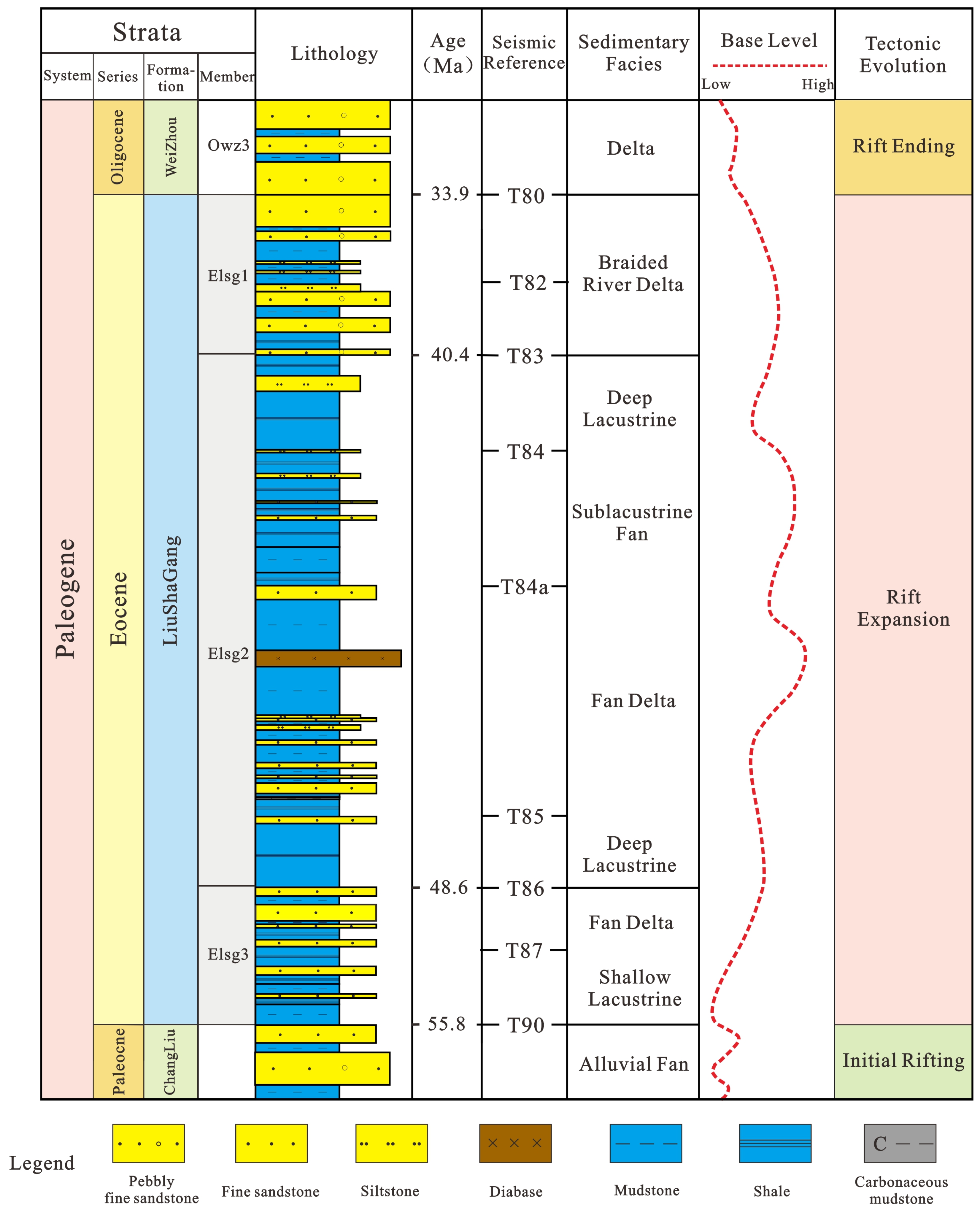
42]. The Changliu Formation (65.5–55.8 Ma) consists mainly of conglomerate, pebbly sandstone, silty mudstone, and mudstone, representing alluvial–fluvial facies. The Liushagang Formation (55.8–35 Ma)—the focus of this study—was deposited during the early rifting stage and is ~2000 m thick [
39,
40]. Sequence stratigraphic analysis divides it into three members: (1) The third member has a “coarse-bottom, fine-top” lithology, with interbedded brown-gray mudstone and gray sandstone. (2) The second member has a “fine–coarse–fine” lithology consisting of (a) basal dark-brown oil shale of semi-deep to deep lacustrine facies, (b) deltaic, fan-deltaic, and sublacustrine fan deposits from the lake regression phase [
37,
43], and (c) gray-black oil shale and shale of deep lacustrine facies at the top. (3) The first member has a “coarse-bottom, fine-top” pattern, with interbedded gray mudstone and sandstone, containing braided river delta deposits [
39,
44,
45]. The Weizhou Formation (35–23 Ma) is up to 3000 m thick, composed mainly of conglomerate, sandstone, and interbedded sandstone–mudstone, with meandering river delta deposits. The study area lies on the hanging wall of the No. 7 Fault System in the southern central sub-depression. During the deposition of the second member of the Liushagang Formation, fan delta systems derived from the Liusha Uplift developed in this area (
Figure 2).
3. Materials and Methods
Extensive data, including core samples, 3D seismic surveys, well logs, thin-section analyses, and laboratory tests, were used to investigate the sedimentary characteristics and reservoir differences of the two fan types in the southern steep-slope zone of the Wushi Sag. All data were provided by the Zhanjiang Branch of the China National Offshore Oil (Zhanjiang, China).
The 3D seismic data cover ~300 km2 of the southern Wushi Sag with a dominant frequency of 30–35 Hz. Seismic interpretation of the two fan types was performed using GeoFrame, focusing on sequence stratigraphic analysis, RMS attribute extraction, paleogeomorphic restoration, drainage system characterization, and fan boundary identification.
Paleogeomorphic restoration used the “three zones and five steps” method, identifying depositional and transgressive denudation zones on seismic profiles. The five steps included (1) tectonic–sedimentary unit division, (2) differential subsidence correction, (3) denudation restoration, (4) sedimentary paleogeomorphic reconstruction, and (5) paleogeomorphology-based sedimentary unit division [
47,
48]. Following restoration, drainage systems were characterized based on topographical variations. Typical seismic profiles were analyzed for fault characteristics (angle, morphology), reflection patterns (progradational geometry, amplitude, frequency), and RMS attributes to interpret the “source–channel–boundary–sink” system of the fans.
The study area included 14 wells (W1–W8, E1–E6). Lithologic logging was used to identify lithologies and sedimentary microfacies. Well logs—gamma ray (GR), acoustic travel time (AC), compensated neutron (CNC), density (DEN), and resistivity (RD)—were applied to differentiate sandstone and mudstone intervals, and cross-plot analysis supported diagenetic facies identification. Oil testing was performed to access hydrocarbon-bearing properties clarifying the macro-sedimentary characteristics of each fan type.
Thin-section petrography was conducted on six wells (W1, W3, W7, W8, E3, E5) using sidewall cores, with the results summarized in technical reports and micrographs to compare petrology and diagenesis between the fan types. Physical property analysis of eight wells (W1, W3, W4, W7, W8, E2, E3, E5) measured porosity and permeability to evaluate reservoir quality differences.
Guided by sedimentary microfacies interpretation and logging cross-plots, diagenetic facies were classified and tied to wells. The distribution of high-quality reservoirs was determined by integrating sedimentary microfacies and diagenetic facies data. Combining seismic, well, and core data with principles of sequence stratigraphy, sedimentology, and reservoir geology, this study summarizes the macro-sedimentary and micro-reservoir characteristics of the two fan, clarifies their control over reservoir quality, and proposes predictive models for reservoir development.
4. Results and Interpretations
4.1. Source-to-Sink Systems
4.1.1. Source Area Characteristics
Using 3D seismic data and paleo-denudation analysis, we reconstructed the geomorphology and drainage systems of the Liusha Uplift in the southern study area. The results show distinct characteristics for the two fan types (
Figure 3). (1) Migratory fans: their provenance areas exhibit intense denudation, cover large areas, and provide ample sediment supply. Their drainage systems are interconnected, forming composite “linear provenance” systems that develop distal migratory source-to-sink systems. (2) Progradational fans: their provenance areas show weak denudation, are smaller, and have limited sediment supply. Their drainage systems are isolated, forming single “point provenance” systems that develop proximal progradational source-to-sink systems.
4.1.2. Channel Characteristics
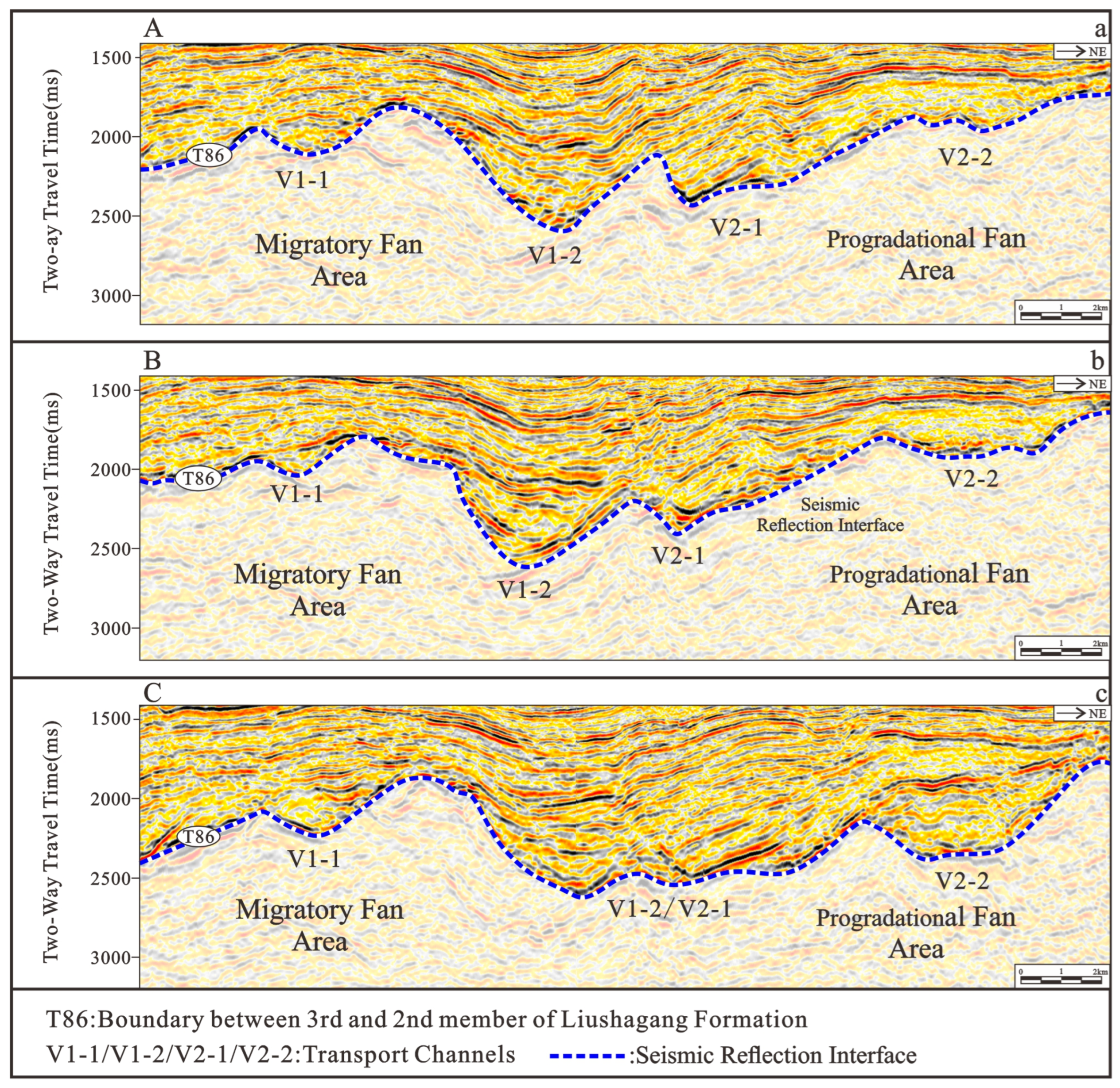
Analysis of three seismic profiles perpendicular to the provenance of the Liusha Uplift in the southern steep-slope zone of the Wushi Sag reveals that transport is dominated by four fault-controlled channels (V1-1, V1-2, V2-1, V2-2). V1-1 and V1-2 correspond to migratory sedimentary systems, while V2-1 and V2-2 correspond to progradational systems. Qualitative and quantitative analysis of channel shape, width, and depth highlights the differences in transport characteristics between the two systems.
Channel V1-1 maintains a “V” shape throughout, averaging 3860 m in width and 340 ms in depth, indicating strong erosional capacity. Channel V2-2 is consistently a “U” shape, averaging 2875 m in width and 250 ms in depth, reflecting weaker erosion. Channels V1-2 and V2-1 are single channels in the early stage but bifurcate later. V1-2 transitions from “U”- to “V”-shaped, with an average width of 5430 m and depth of 770 ms, indicating strong erosion. V2-1 remains “U”-shaped, averaging 3600 m in width and 310 ms in depth, suggesting relatively weak erosional capacity (
Figure 4).
In summary, migratory fan channels are wide, deep, strongly erosive, and “V”-shaped, with ample sediment supply, whereas progradational fan channels are narrower, shallower, weakly erosive, and “U”-shaped, with limited sediment supply.
4.1.3. Boundary Characteristics
The No. 7 Fault System is the primary sedimentary boundary in the southern steep-slope zone of the Wushi Sag. It strikes NEE, extends ~45 km, and dips NNW, with its dip angle decreasing from west to east. Its geometry transitions from listric in the west to fault benches and multi-level Y-shaped patterns eastward. Fault activity gradually weakened during the deposition of the second member of the Liushagang Formation [
49,
50].
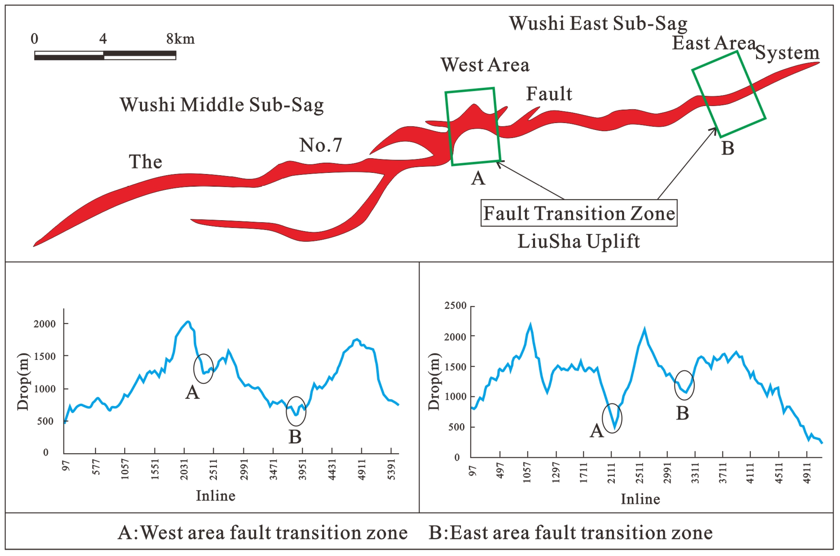
This paper characterizes the fault boundary based on its development and transfer zone morphology. From the early to late stages of the second member of the Liushagang Formation, fault activity in the west weakened, with the maximum fault throw decreasing from 1400 m to 500 m (
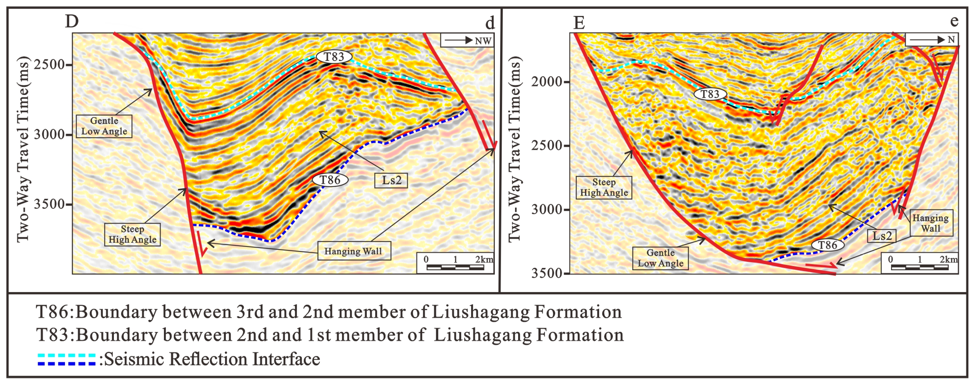
Figure 5). Seismic reflections show a low-angle upper fault bench overlying a high-angle boundary fault, forming a boundary that is gentle above and steep below (
Figure 6). In contrast, fault activity in the east is strengthened, with the maximum throw increasing from 500 m to 800 m (
Figure 5). Here, the upper section is controlled by a high fault, while the lower section shows a progressively shallower dip as the fault dies out, producing a steep-above, gentle-below boundary (
Figure 6). These contrasting fault patterns control the internal sedimentary architecture of the basin.
4.1.4. Depositional System Characteristics
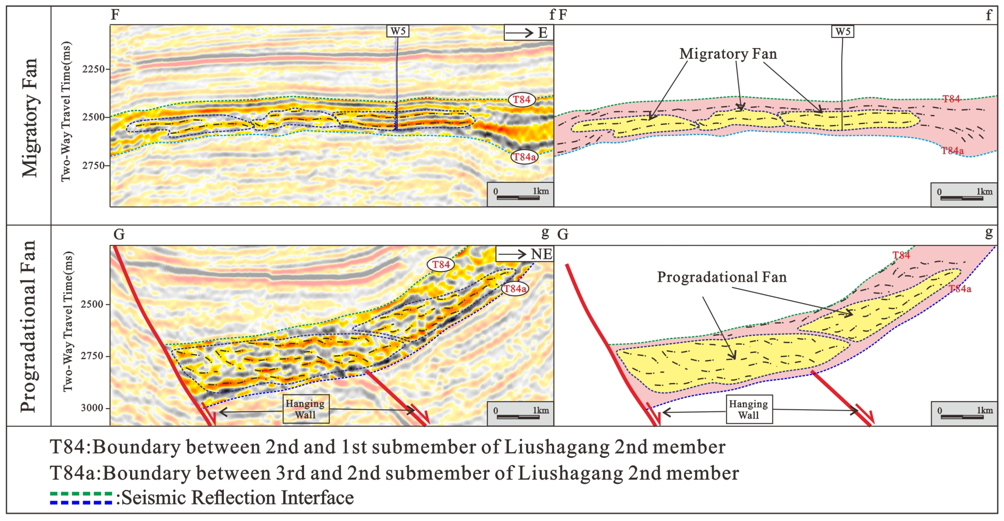
Differences between the two depositional systems are evident in seismic facies, planar attributes, and lithologic associations. For migratory fans, three development stages are identifiable in profiles perpendicular to the source. Seismic reflections show left–right migration, with medium-to-strong amplitudes and moderately continuous parallel reflections (
Figure 7). Lithology is dominated by fine sandstone and argillaceous siltstone interbedded calcite with mudstone, containing both oil and water-bearing layers (
Figure 8B). High RMS seismic attribute values occur in the fan center (
Figure 8A). In map view, successive fans overlap laterally, forming a broad, fan-shaped delta with a relatively large areal extend (
Figure 8C).
For progradational fans, two development stages are identifiable in profiles perpendicular to the source. Seismic reflections show successive forward progradation with medium-to-strong amplitudes and moderately continuous progradational reflections (
Figure 7). Lithology is dominated by mudstone interbedded with fine sandstone and silty mudstone (
Figure 8E). High RMS seismic attribute values occur at the fan front (
Figure 8D). In map view, fans of successive stages show continuous progradation, forming a relatively small, broom-shaped delta (
Figure 8C).
4.2. Reservoir Characteristics
4.2.1. Reservoir Petrological Characteristics
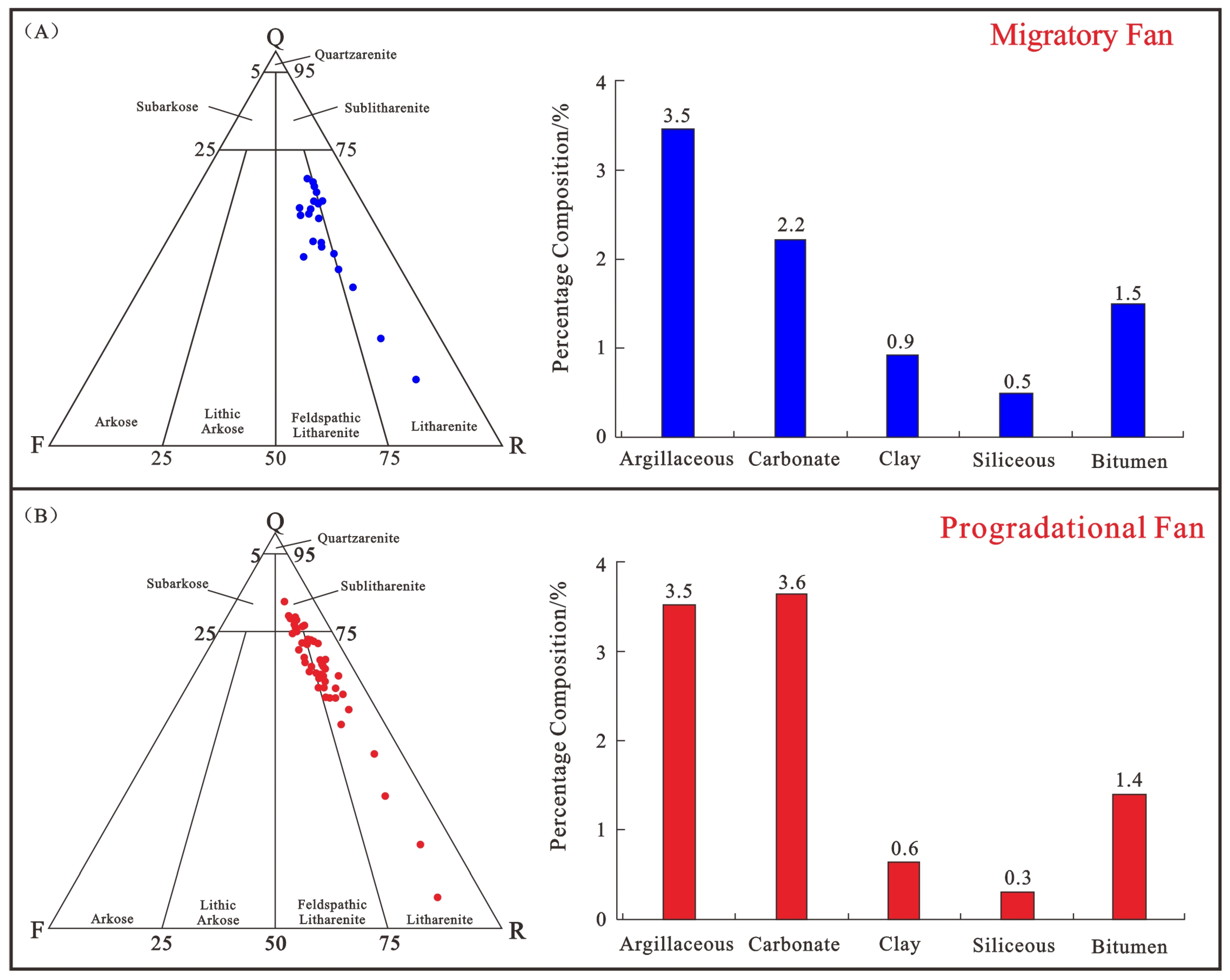
Thin-section and physical property analyses were performed on sidewall core samples from eight drill holes. Grain composition and interstitial materials were statistically evaluated, using triangular diagrams and bar charts. Results show that migratory fans are dominated by feldspathic litharenites and litharenites, with the interstitial materials mainly comprising an argillaceous matrix (
Table 1,
Figure 9A). Progradational fans are dominated by litharenites, feldspathic litharenites, and lithic quartz arenites, with the interstitial materials mainly composed of an argillaceous matrix and carbonates (
Table 1,
Figure 9B).
4.2.2. Reservoir Diagenesis
This study focuses on differences between the two fan types in terms of compaction, cementation, and dissolution, to guide subsequent diagenetic facies analysis.
Migratory fan bodies, formed by overlapping sedimentary units, have greater thickness, lower mud-to-sand ratios, and relatively weak compaction, characterized mainly by point–line grain contacts (
Figure 10A). Dissolution is intense, producing well-developed secondary pores (
Figure 10B). Carbonate material from altered lithic fragments rarely forms carbonate cement within sand bodies; at greater burial depths, argillaceous cementation predominates (
Figure 10C).
Progradational fan bodies, formed by continuous sediment progradation, have relatively thin sand bodies, high mud-to-sand ratios, and well-developed interbedded layers. Particle compaction is strong, with concavo-convex grain contacts (
Figure 10D). Dissolution is weak, and secondary pores are scarce. Carbonate materials from altered carbonate lithic fragments readily form carbonate cement within the sand bodies, resulting in reservoirs controlled by both argillaceous and carbonate cementation (
Figure 10E,F).
4.2.3. Reservoir Physical Property Characteristics
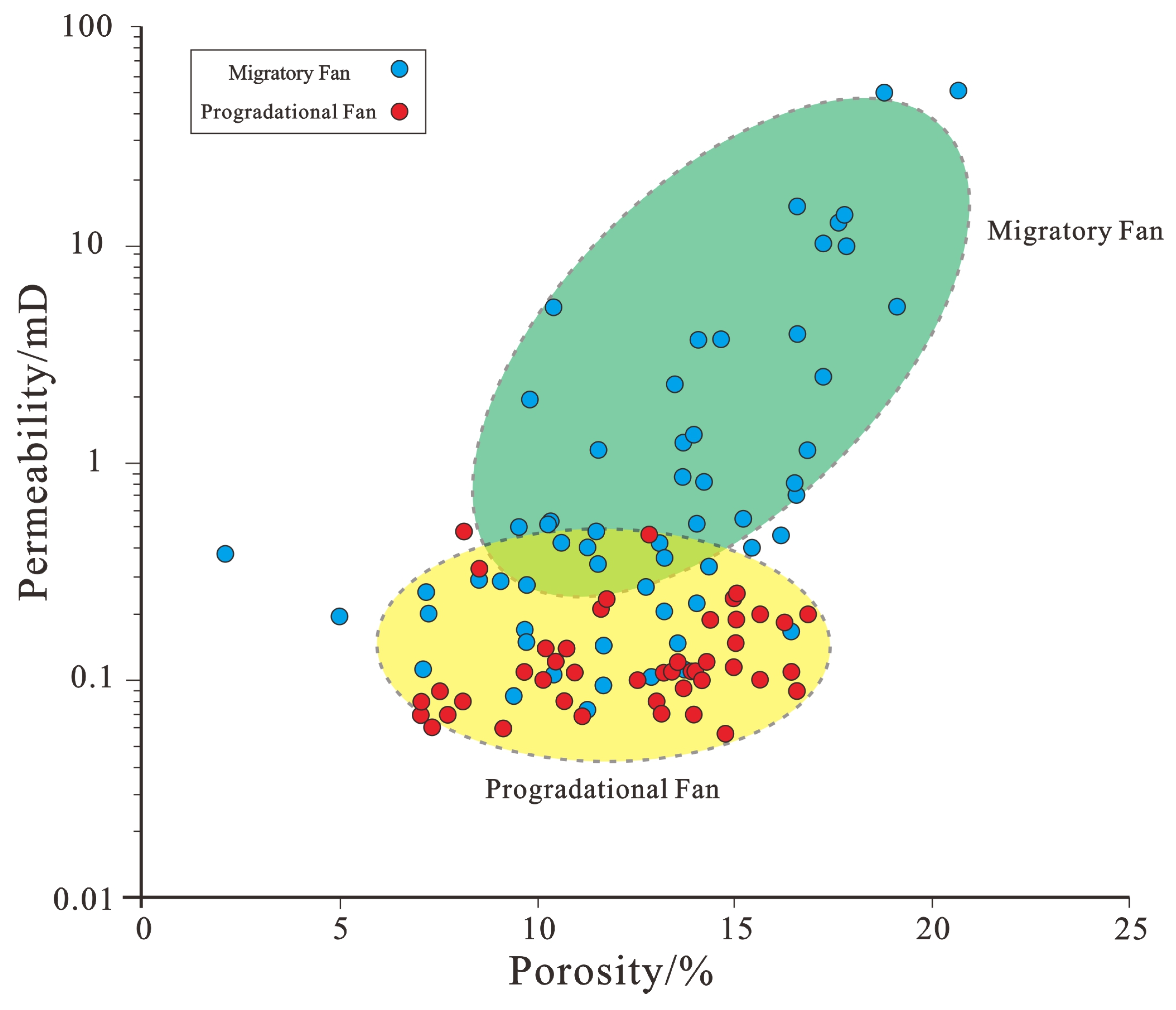
Statistical analysis of reservoir properties shows significant differences in porosity and permeability between migratory and progradational fans in the southern steep-slope zone of the Wushi Sag. Overall, migratory fans exhibit higher average porosity and permeability.
Porosity: 5.7–21.0%, (avg. 13.28%).
Permeability: 0.06–288 mD, (avg. 8.38 mD) (
Figure 11).
Porosity: 2.1–20.6%, (avg. 12.86%).
Permeability: 0.07–51.96 mD, (avg. 3.58 mD) (
Figure 11).
5. Discussion
By comparing the two fan types in the southern steep-slope zone of the Wushi Sag, the controlling factors and reservoir development models of progradational and migratory systems were summarized, and favorable exploration directions for both systems were identified.
5.1. Controlling Factors
Through a comparison of the source-to-sink and reservoir differences between migratory and progradational fans in the Wushi Sag, it is considered that sedimentary factors (macroscopic) and lithofacies factors (microscopic) jointly control the differences between the two types of fan.
5.1.1. Sedimentary Factors
Sedimentary factors underlie the differences between the two fan types, controlling their development characteristics and scales. In the southern steep-slope zone of the Wushi Sag, fan development is influenced by a major high-angle boundary fault. Distinct tectonic–geomorphic settings produce different “source–channel–boundary–sink” parameters, which determine the characteristics of the resulting sedimentary bodies. Comprehensive analysis of these parameters clarifies the tectonic–geomorphic–sedimentary coupling patterns.
Within the source-to-sink system, sink areas shaped by boundary fault patterns are classified as migratory and progradational fans. Migratory fan source areas experience strong erosion; weathered clastics, transported over long distances by stable drainage systems, follow a “gentle then steep” valley profile, migrate laterally, and are deposited in the sink area as fan delta bodies. In contrast, progradational fan source areas experience weaker erosion; clastics pass through a “steep then gentle” valley profile, prograde forward under accommodation space constrains, and form broom-shaped fan delta bodies (
Table 2).
5.1.2. Diagenetic Facies Factors
Lithofacies factors are key in microscopically controlling reservoir quality and are primarily expressed through differences in diagenetic facies. Analyzing the diagenetic facies of migratory sedimentary systems helps clarify the microscopic distinctions between the two sedimentary system types.
Based on thin-section analysis, well log characteristics, and cross-plots, four diagenetic facies types were identified using two complimentary approaches:
The diagenetic facies are classified using the following two methods:
- ①
Thin-section observations and quantitative statistics:
Type I: Medium compaction, weak cementation, strong dissolution, well-developed pores, porosity > 15%;
Type II: Medium compaction with clay mineral cementation medium, moderate dissolution, porosity 10–15%;
Type III: Strong compaction with argillaceous filling; matrix micropores dominate, poor connectivity, porosity 5–10%;
Type IV: Strong compaction with carbonate cementation and weak dissolution, very few pores, poor connectivity, porosity < 5%.
- ②
Logging curves and cross plots (AC, CNC, DEN, RD) (
Table 3):
Type I: Medium compaction, weak cementation, strong dissolution, low RD/DEN, high CNC/AC;
Type II: Medium compaction, clay cementation, moderate dissolution, intermediate RD, DEN, CNC, and AC values;
Type III: Strong compaction with argillaceous filling, high RD/DEN, low CNC/AC;
Type IV: Strong compaction with carbonate cementation, weak dissolution, high RD, medium–high DEN, low CNC and AC values.
- 2.
Diagenetic facies in well-tie profiles
Well-tie profile analysis shows that in stacked migratory fan bodies, Type I and II facies dominate the middle section, while Types III and IV occur at the margins. With increasing depth, facies transition progressively from Types I–II to Types III–IV (
Figure 12).
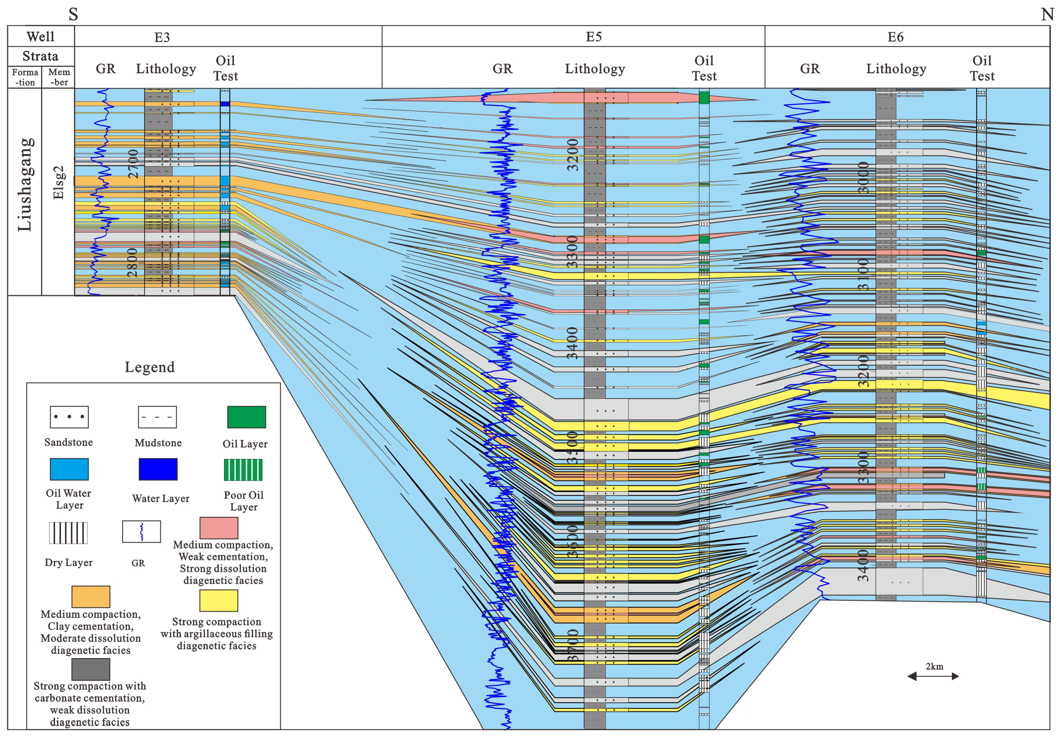
In progradational fan bodies, Type I facies (medium compaction, weak cementation) occur only in small amounts at the fan front, while Types III (strong compaction with argillaceous filling) and IV (strong compaction with carbonate cementation) are predominant. With increasing depth, facies transition from Type II to Types III–IV (
Figure 13).
5.2. Distribution of High-Quality Reservoirs
In this study, reservoirs are classified by porosity and permeability into three types (
Table 4): Type Ⅰ (conventional): (porosity > 10%, permeability > 10 mD); Type Ⅱ (low-permeability): (porosity 5–10%, permeability 1–10 mD); and Type Ⅲ (tight): (porosity < 5%, permeability < 1 mD).
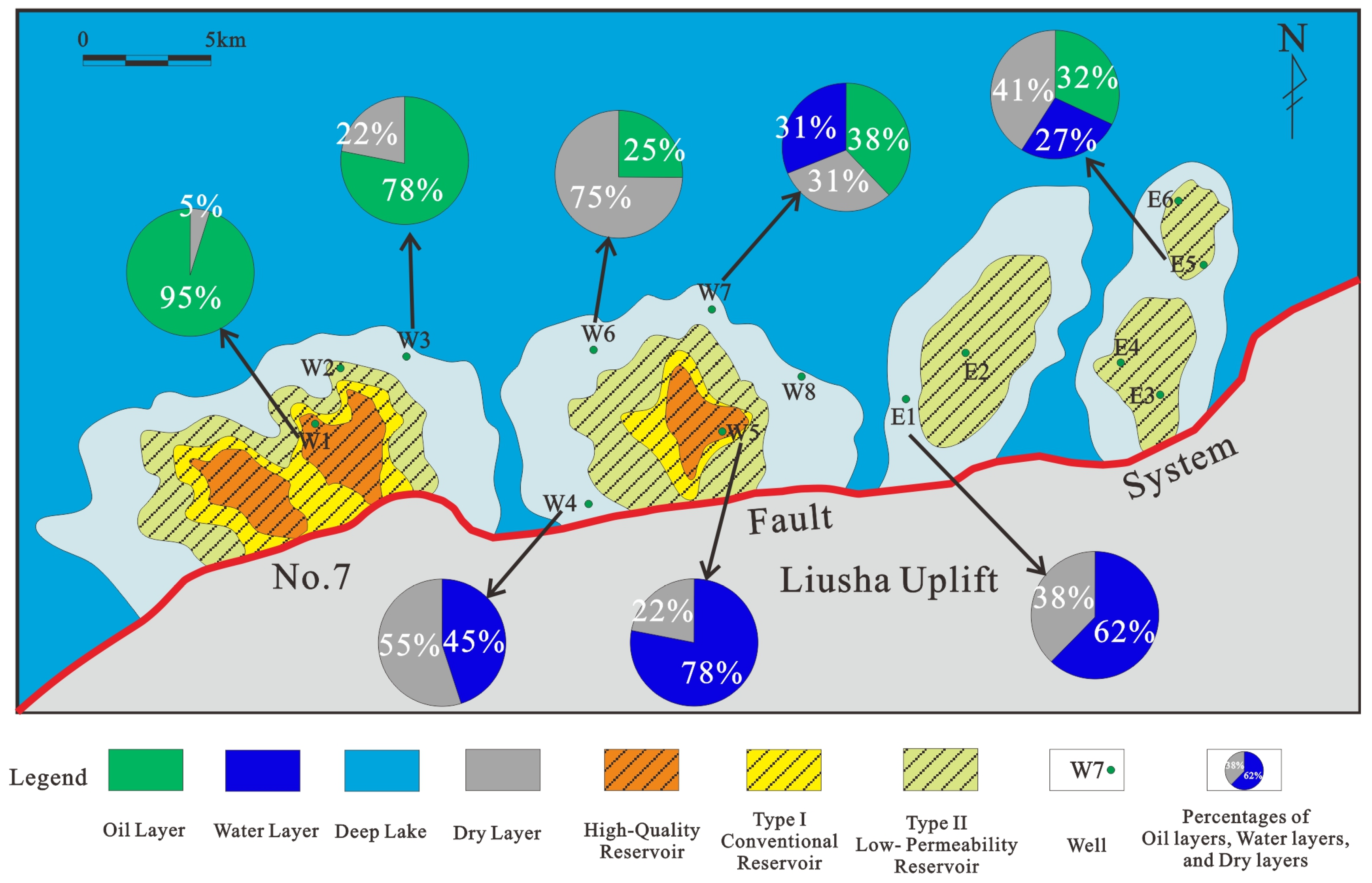
Based on sedimentary and diagenetic facies characteristics, migratory fans in the southern steep-slope zone of the Wushi Sag are dominated by Type I–II reservoirs. Well W1 is located in a sweet spot reservoir, surrounded by Type I conventional and Type II low-permeability reservoirs, with Type III tight reservoirs at the margins. Similarly, well W5 lies in a sweet spot reservoir, with Type I–II reservoirs nearby and abundant Type III reservoirs on the outer edge. Sweet spot and Type I reservoirs form an annular distribution and occupy a relatively large area. Overall, the reservoirs show high oil-bearing properties and are dominated by oil layers (
Figure 14).
Progradational fans are dominated by Type II–III reservoirs. Well E2 is located in a Type II reservoir with Type III tight reservoirs at the margins. Wells E3, E4, E5, and E6 are also within Type II reservoirs, again bordered by Type III reservoirs. Type II reservoirs are limited in extent, occurring mainly in the middle of sand bodies in isolated islands and channel-like patterns. Overall, these reservoirs have low oil-bearing properties and are dominated by dry layers (
Figure 14).
Migratory fan reservoirs are primarily controlled by shale content, are dominated by Type I–II diagenetic facies, and exhibit good physical properties, making them high-quality reservoirs. Progradational fan reservoirs are influenced by both shale content and carbonate cementation, dominated by Type III–IV facies, with poor physical properties, making them lower-quality reservoirs.
5.3. Reservoir Model
Considering the controlling factors and differences between migratory and progradational fans in the southern steep-slope zone, prediction models for high-quality reservoirs were developed, including separate models for migratory progradational systems.
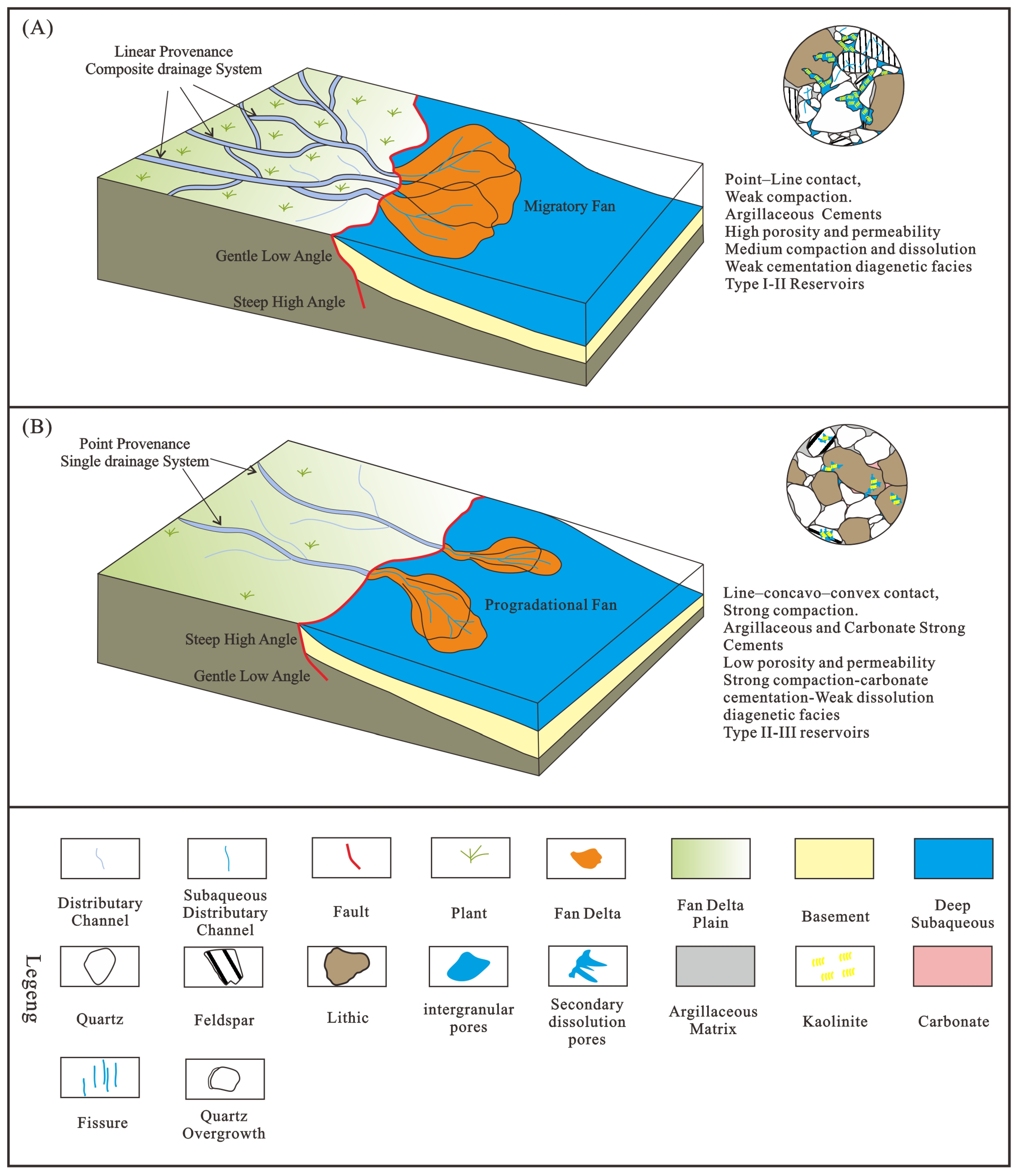
The migratory reservoir model is primarily fed by composite drainage systems with long transport distances, wide catchments, and abundant material supply. It is characterized by wide, deep V-shaped valleys that facilitate sediment input. Boundaries are marked by large steep-slope faults, and the system occurs in fault transfer zones with strong activity, displaying a “gentle-then-steep” profile. The lithology consists mainly of pebble-bearing medium-to-fine-grained sandstones interbedded with mudstones, with high sand content. It represents fan–delta–front subfacies with considerable thickness and lateral extend. Grains show point-to-line contacts, with compaction, abundant clay cement, and moderate cementation, resulting in relatively high porosity and permeability. Diagenesis is dominated by Type I facies (medium compaction, medium dissolution, weak cementation) and Type II facies (medium–strong compaction, clay mineral cementation, moderate dissolution), producing primarily Type I–II reservoirs (
Figure 15A).
The progradational reservoir model is mainly supplied by a single drainage system, with a short transport distance, limited catchments, and low sediment supply. It features narrow, shallow U-shaped valleys where sediment progrades forward with minimal lateral migration. Boundaries are defined by steep-slope faults, and the system lies in fault transfer zones with weak activity, showing a “steep-then-gentle” profile. The lithology consists of interbedded medium-to-fine-grained sandstones and mudstones, with low sand content. It represents fan–delta–front subfacies with thinner, more restricted deposits. Grains exhibit line-to-concavo-convex contacts and strong compaction. Both clay and carbonate cements are well developed, resulting in strong cementation, low porosity, and low permeability. Diagenesis is dominated by Type III facies (medium–strong compaction, clay filling) and Type IV facies (medium compaction, strong carbonate cementation, weak dissolution), producing primarily Type II–III reservoirs (
Figure 15B).
6. Conclusions
The study area is located in the southern steep-slope zone of the Wushi Sag, Beibuwan Basin, South China Sea. Using 3D seismic data, core samples, drilling and logging data, thin sections, and laboratory analysis, this study compares the sedimentary and reservoir characteristics of migratory and progradational fan deltas and summarizes reservoir models for both types. The findings provide theoretical support for future oil and gas exploration and development in the Wushi Sag.
In the Second Member of the Liushagang Formation, in the southern steep-slope zone of the Wushi Sag (Beibuwan Basin), both migratory and progradational fan delta systems are developed. By comparing these systems, their sedimentary and reservoir characteristics were summarized, and predictive reservoir development models for both fan types were established.
The integration of sedimentary and reservoir characteristics clarifies the key differences between the two fan types. The development of sedimentary factors such as sources, channels, boundaries, and sinks controls fan development at the macroscopic scale, while reservoir factors such as the diagenetic facies types and high-quality reservoir distribution control it microscopically. Migratory fans exhibit superior sedimentary and reservoir conditions compared to progradational fans, making them the primary targets for future exploration.
Two reservoir development models are proposed, as follows:
The Migratory Fan Model is characterized by moderate burial depth, extensive drainage systems, wide and deep transport channels, and ample sediment supply and develops in fault transfer zones with strong fault activity; its lithology is dominated by gravelly coarse-to medium-grained sandstones, mainly in fan–delta–front distributary channel microfacies. Diagenesis is weak, resulting in high porosity and permeability and predominantly Type I–II reservoirs.
The Progradational Fan Model is characterized by greater burial depth, short drainage systems, narrow and shallow transport channels, and limited sediment supply. Developed in fault transfer zones with weak fault activity, its lithology consists of medium sandstones interbedded with mudstones, mainly in fan–delta–front interdistributary bay microfacies. Strong diagenesis leads to lower porosity and permeability and predominantly Type II–III reservoirs.
Author Contributions
Conceptualization, investigation, and data curation, S.L., Y.L., H.Y. and W.Z.; methodology, H.Z. and Y.L.; formal analysis, validation, software, resources, and visualization, S.L., Z.L. and X.Y.; writing—original draft preparation, S.L.; writing—review and editing, S.L. and H.Z.; supervision, H.Z.; project administration and funding acquisition, H.Z. All authors have read and agreed to the published version of the manuscript.
Funding
This work was supported by Major Outsourcing Projects of CNOOC (grant number CCL2020ZJFN0343).
Data Availability Statement
The original contributions presented in this study are included in the article. Further inquiries can be directed to the corresponding author.
Acknowledgments
We thank the Zhanjiang Branch of the China National Offshore Oil Corporation for providing data and permitting the publication of the results. We are also grateful to the Hydrogeology and Engineering Geology Institute of Hubei Geological Bureau and China University of Geosciences (Wuhan) for material and technical support and to the editorial department for their assistance and valuable comments.
Conflicts of Interest
The authors declare no conflicts of interest.
References
- Holmes, A. Principles of Physical Geology, 2nd ed.; Thomas Nelson and Sons: London, UK, 1965. [Google Scholar]
- Ethridge, F.G.; Wescott, W.A. Tectonic Setting, Recognition and Hydrocarbon Reservoir Potential of Fan-Delta Deposits. In Sedimentology of Gravels and Conglomerates; Canadian Society of Petroleum Geologists Memoir 10; CSPG: Calgary, AB, Canada, 1984; pp. 217–235. [Google Scholar]
- Nemec, W.; Steel, R.J. Fan Deltas and Other Coarse-Grained Deltas. In Sedimentary Environments and Facies; Blackwell Scientific Publications: Oxford, UK, 1988; pp. 339–418. [Google Scholar]
- Henry, L.C.; Faerber, R.D.; Steinhoff, D.; Bolivar, M.; Browning, E. Ponding and compartmentalization of a giant Paleogene slope fan by mass transport complexes, offshore Newfoundland, Canada. Mar. Pet. Geol. 2024, 167, 106939. [Google Scholar] [CrossRef]
- Rohais, S.; Eschard, R.; Guillocheau, F. Depositional model and stratigraphyic architecture of rift climax Gilbert-type fan deltas (Gulf of Corinth, Greece). Sediment. Geol. 2008, 210, 132–145. [Google Scholar] [CrossRef]
- He, L.; Amorosi, A.; Ye, S.Y.; Xue, C.T.; Yang, S.X.; Laws, E.A. River avulsions and sedimentary evolution of the Luanhe fan-delta system (North China) since the late Pleistocene. Mar. Geol. 2020, 425, 106194. [Google Scholar] [CrossRef]
- Kang, K.; Hu, W.X.; Cao, J.; Wu, H.G.; Xiang, B.L.; Wang, J. Controls on reservoir quality in fan-deltaic conglomerates: Insight from the Lower Triassic Baikouquan Formation, Junggar Basin, China. Mar. Pet. Geol. 2019, 103, 55–75. [Google Scholar] [CrossRef]
- Hori, K.; Saito, Y.; Zhao, Q.; Cheng, X.; Wang, P.; Sato, Y.; Li, C. Sedimentary facies and Holocene progradation rates of the Changjiang (Yangtze) delta, China. Geomorphology 2001, 41, 233–248. [Google Scholar] [CrossRef]
- Magyar, I.; Radivojević, D.; Sztanó, O.; Synak, R.; Ujszászi, K.; Pócsik, M. Progradation of the paleo-Danube shelf margin across the Pannonian Basin during the Late Miocene and Early Pliocene. Glob. Planet. Change 2013, 103, 168–173. [Google Scholar] [CrossRef]
- Saito, Y.; Wei, H.; Zhou, Y.; Nishimura, A.; Sato, Y.; Yokota, S. Delta progradation and chenier formation in the Huanghe (Yellow River) delta, China. J. Asian Earth Sci. 2000, 18, 489–497. [Google Scholar] [CrossRef]
- Xu, T.; Shi, X.; Liu, S.; Qiao, S.; Wang, G.; Wang, X.; Yao, Z.; Yang, G.; Fang, X.; Li, X.; et al. Formation processes and evolution of Holocene sediments in the Yangtze offshore area: A review and new interpretation on the response to sea-level rise and deltaic progradation. Quat. Int. 2018, 490, 33–42. [Google Scholar] [CrossRef]
- Yu, S.; Chen, F.; Jing, X.; Chen, C.; Zhuang, C.; Li, Q.; Zhou, Y.; Xia, Z.; Gan, H.; Fisch, K.; et al. Increasing terrigenous pollen input in the late Holocene: Indications of intensive human activity and accelerated delta plain progradation. Mar. Geol. 2021, 439, 106547. [Google Scholar] [CrossRef]
- Menegoni, N.; Inama, R.; Crozi, M.; Perotti, C. Early deformation structures connected to the progradation of a carbonate platform: The case of the Nuvolau Cassian platform (Dolomites—Italy). Mar. Petrol. Geol. 2022, 138, 105574. [Google Scholar] [CrossRef]
- Oliver, T.S.; Donaldson, P.; Tamura, T. Embayment-scale coastal evolution and shoreline progradation in southeast Tasmania, Australia. Mar. Geol. 2022, 444, 106725. [Google Scholar] [CrossRef]
- Lykousis, V.; Karageorgis, A.P.; Chronis, G.T. Delta progradation and sediment fluxes since the last glacial in the Thermaikos Gulf and the Sporades Basin, NW Aegean Sea, Greece. Mar. Geol. 2005, 222–223, 381–397. [Google Scholar] [CrossRef]
- Val, J.; Bádenas, B.; Aurell, M. Sedimentary architecture of a prograding oolitic-siliciclastic wedge: Response to changes in wave-base oscillation (Kimmeridgian, Iberian Basin). Mar. Pet. Geol. 2018, 96, 113–127. [Google Scholar] [CrossRef]
- Migeon, S.; Savoye, B.; Faugeres, J.C. Quaternary development of migrating sediment waves in the Var deep-sea fan: Distribution, growth pattern, and implication for levee evolution. Sediment. Geol. 2000, 133, 265–293. [Google Scholar] [CrossRef]
- Hou, G.F.; Sun, X.W.; Li, C.; Liu, Q.; Zeng, Q.L.; Xiong, R.; Cao, Q.B. Depositional features of the fan delta from lower Cretaceous Kezilesu Groupin Yecheng sag, southwestern Tarim Basin. Geol. China 2012, 39, 947–953, (In Chinese with English Abstract). [Google Scholar]
- Li, Y.; Pu, R.; Zhang, G.; Zhao, X.; Li, Y. Architecture, controlling factors and evolution history of unidirectionally upstream-migrating turbidite channels: A case study from southern Qiongdongnan Basin, northern South China Sea. Mar. Petrol. Geol. 2022, 141, 105706. [Google Scholar] [CrossRef]
- Pickering, K.; Coleman, J.; Cremer, M.; Droz, L.; Kohl, B.; Normark, W.; Connell, S.O.; Stow, D.; Wright, A.M. A high sinuosity, laterally migrating submarine fan channel-levee-overbank: Results from DSDP Leg 96 on the Mississippi Fan, Gulf of Mexico. Mar. Petrol. Geol. 1986, 3, 3–18. [Google Scholar] [CrossRef]
- Zhu, M.; Graham, S.; Pang, X.; McHargue, T. Characteristics of migrating submarine canyons from the middle Miocene to present: Implications for paleoceanographic circulation, northern South China Sea. Mar. Petrol. Geol. 2010, 27, 307–319. [Google Scholar] [CrossRef]
- Yang, H.; Hu, M.Y.; Cai, M.; Wang, D.; Cai, Q.S. Sedimentary characteristics and development patterns of progradational shallow-water delta in Member Nen 3 and Nen 4 of Daqingzijing area in south Songliao Basi Applying seismic geomorphology to delineate switched sequence stratigraphic architecture in lacustrine rift basins An example from the Pearl River Mouth Basin, northern South China Sea n. Pet. Geol. Oilfield Dev. Daqing 2022, 41, 1–10. [Google Scholar]
- Liu, S.H.; Goff, J.A. Lower shoreface seismic stratigraphy and morphology off Fire Island, New York: Evidence for lobate progradation and linear erosion. Cont. Shelf Res. 2018, 163, 23–34. [Google Scholar] [CrossRef]
- Liu, Y.; Sun, Q.L.; Fan, D.D.; Dai, B.; Ma, F.W.; Xu, L.C.; Chen, J.; Chen, Z.Y. Early to Middle Holocene sea level fluctuation, coastal progradation and the Neolithic occupation in the Yaojiang Valley of southern Hangzhou Bay, Eastern China. Quat. Sci. Rev. 2018, 189, 91–104. [Google Scholar] [CrossRef]
- Sztanó, O.; Szafián, P.; Magyar, I.; Horányi, A.; Bada, G.; Hughes, D.W.; Hoyer, D.L.; Wallis, R.J. Aggradation and progradation controlled clinothems and deep-water sand delivery model in the Neogene Lake Pannon, Makó Trough, Pannonian Basin, SE Hungary. Glob. Planet. Change 2013, 103, 149–167. [Google Scholar] [CrossRef]
- Gong, C.; Sztanó, O.; Steel, R.J.; Xian, B.; Galloway, W.E.; Bada, G. Critical differences in sediment delivery and partitioning between marine and lacustrine basins: A comparison of marine and lacustrine aggradational to progradational clinothem pairs. GSA Bull. 2019, 131, 766–781. [Google Scholar] [CrossRef]
- Chen, Y.H.; Yao, G.S.; Wang, X.F.; Lv, F.L.; Shao, D.L.; Lu, Y.T.; Cao, Q.B.; Tang, P.C. Flow processes of the interaction between turbidity flows and bottom currents in sinuous unidirectionally migrating channels: An example from the Oligocene channels in the Rovuma Basin, offshore Mozambique. Sediment. Geol. 2020, 404, 105680. [Google Scholar] [CrossRef]
- Liu, J.; Xian, B.; Ji, Y.; Gong, C.; Wang, J.; Wang, Z.; Chen, P.; Song, D.; Wei, W.; Zhang, X.; et al. Alternating of aggradation and progradation dominated clinothems and its implications for sediment delivery to deep lake: The Eocene Dongying Depression, Bohai Bay Basin, east China. Mar. Petrol. Geol. 2020, 114, 104197. [Google Scholar] [CrossRef]
- Li, H.; Wang, Y.M.; Zhu, W.L.; Xu, Q.; He, Y.B.; Tang, W.; Zhuo, H.T.; Wang, D.; Wu, J.P.; Li, D. Seismic characteristics and processes of the Plio-Quaternary unidirectionally migrating channels and contourites in the northern slope of the South China Sea. Mar. Petrol. Geol. 2013, 43, 370–380. [Google Scholar] [CrossRef]
- The Editorial Department of Chinese National Geography. Guangxi Beibu Gulf. Chin. Natl. Geogr. 2018, 2, 122–135. [Google Scholar]
- Wu, S.G.; Han, Q.H.; Ma, Y.B.; Dong, D.D.; Lü, F.L. Petroleum system in deepwater basins of the northern South China Sea. J. Earth Sci. 2009, 20, 124–135. [Google Scholar] [CrossRef]
- Zhang, G.C.; Xie, X.J.; Wang, W.Y.; Liu, S.X.; Wang, Y.B.; Dong, W.; Shen, H.L. Tectonic types of petroliferous basins and its exploration potential in the South China Sea. Acta Pet. Sin. 2013, 34, 611–627, (In Chinese with English Abstract). [Google Scholar]
- Xi, M.H.; Yu, X.B.; Huang, J.T. Paleogene stratigraphic sequence and sedimentary feature in the west of Weixinan Depression. Offshore Oil 2007, 27, 112–121. [Google Scholar]
- Liu, P.; Xia, B.; Tang, Z.Q.; Wang, X.G.; Zhang, Y. Fluid inclusions in reservoirs of Weixinan Sag, Beibuwan Basin. Petrol. Explor. Dev. 2008, 35, 164–200. [Google Scholar] [CrossRef]
- Liu, E.T.; Wang, H.; Li, Y.; Zhou, W.; Leonard, N.D.; Lin, Z.L.; Ma, Q.L. Sedimentary characteristics and tectonic setting of sublacustrine fans in a half-graben rift depression, Beibuwan Basin, South China Sea. Mar. Petrol. Geol. 2014, 52, 9–21. [Google Scholar] [CrossRef]
- Yin, J.; Wei, L.; Fan, C.; Xu, C.; Man, Y.; Hu, D.; Hu, L.; Hou, D. Oil origin and migratory direction in Wushi sag, Beibuwan Basin, South China Sea. Mar. Petrol. Geol. 2022, 145, 105848. [Google Scholar] [CrossRef]
- Hu, D.S.; Deng, Y.; Zhang, J.X.; Zuo, Q.M.; He, W.J. Palaeogene Fault System and Hydrocarbon Accumulation in East Wushi Sag. J. Southwest Pet. Univ. Sci. Technol. Ed. 2016, 38, 27–36, (In Chinese with English Abstract). [Google Scholar] [CrossRef]
- Fan, C.W.; Zhou, G.; Tang, X.; Chen, K. Accumulation conditions and key technologies for exploration and development of Wushi oilfield in Beibuwan Basin. Acta Pet. Sin. 2025, 4, 466–482, (In Chinese with English Abstract). [Google Scholar] [CrossRef]
- Huang, B.J.; Tian, H.; Wilkins, R.W.T.; Xiao, X.M.; Li, L. Geochemical characteristics, palaeoenvironment and formation model of Eocene organic-rich shales in the Beibuwan Basin. South China Sea. Mar. Petrol. Geol. 2013, 48, 77–89. [Google Scholar] [CrossRef]
- Xie, N.; Cao, Y.C.; Wang, J.; Jing, J.H.; Zhang, W.J.; Zhong, Z.H. Diagenesis and its control on physical property of the reservoirs in the 3rd member of the Paleogene Liushagang Formation in Weixinan Depression, Beibuwan Basin. Natur. Gas Geosci. 2019, 30, 1743–1754, (In Chinese with English Abstract). [Google Scholar]
- Ren, Y.; Sun, L.; Fang, M.J.; Yu, X.H.; Li, S.L.; Gao, M.X. Sequence stratigraphic analysis of the Eocene in Wushi Sag, Beibuwan Basin. J. Northeast Pet. Univ. 2022, 46, 26–39. Available online: https://xuebao.nepu.edu.cn/info/1406/10316.htm (accessed on 29 September 2025). (In Chinese with English Abstract).
- Wang, Y.; Zhang, H.; Yang, C.Q.; Qi, Z.; Ma, H.S.; Wang, M.; Chen, J. Sedimentary Model and Its Architectural Characteristics of Delta under the Control of Fault-Rupture-Sag Coupling in Wushi Sag. Spec. Oil Gas Reserv. 2022, 29, 34–41, (In Chinese with English Abstract). [Google Scholar] [CrossRef]
- Mou, J.H.; He, J.; Jiang, T.; He, W.J.; Liu, S.; Zeng, J.H.; Qin, C.Y.; Wang, H. Sedimentary characteristics and development mechanism of Sublacustrine Fan in the Second Member of Liushagang Formation of eastern Wushi Sag, Beibuwan Basin. Mar. Geol. Quat. Geol. 2025, 5, 1–18, (In Chinese with English Abstract). [Google Scholar] [CrossRef]
- Li, M.J.; Wang, T.G.; Liu, J.; Lu, H.; Wu, W.Q.; Gao, L.H. Occurrence and origin of carbon dioxide in the fushan depression, Beibuwan Basin, south China sea. Mar. Petrol. Geol. 2008, 25, 500–513. [Google Scholar] [CrossRef]
- Hu, D.S.; Man, X.; Gao, M.H.; Li, W.L.; Yu, M. Source rock characteristics and exploration prospect in western subsag of Wushi Sag in beibuwan Basin. China Offshore Oil Gas 2025, 37, 13–25, (In Chinese with English Abstract). [Google Scholar] [CrossRef]
- Liu, S.; Zhu, H.T.; Liu, Q.H.; Zhou, Z.Q.; Chen, J.H. Along-Strike Reservoir Development of Steep-Slope Depositional Systems: Case Study from Liushagang Formation in the Weixinan Sag, Beibuwan Basin, South China Sea. Energies 2023, 16, 804. [Google Scholar] [CrossRef]
- Zhao, Q.; Zhu, H.T.; Zhang, X.T.; Liu, Q.H.; Qiu, X.W.; Li, M. Geomorphologic reconstruction of an uplift in a continental basin with a source-to-sink balance: An example from the Huizhou-Lufeng uplift, Pearl River Mouth Basin, South China sea. Mar. Pet. Geol. 2021, 128, 104984. [Google Scholar] [CrossRef]
- Zhu, H.T.; Li, S.; Shu, Y.; Yang, X.H.; Mei, L.F. Applying seismic geomorphology to delineate switched sequence stratigraphic architecture in lacustrine rift basins: An example from the Pearl River Mouth Basin, northern South China Sea. Mar. Petrol. Geol. 2016, 78, 785–796. [Google Scholar] [CrossRef]
- Man, Y.; Fan, C.W.; Xue, H.T.; Jin, Q.Y.; Huang, Q. Evolutionary characteristics of fault system and its control effect on hydrocarbon accumulation in Wushi Sag, Beibuwan Basin. J. Northeast Pet. Univ. 2022, 46, 37–47, (In Chinese with English Abstract). [Google Scholar] [CrossRef]
- Man, Y.; Deng, Y.; Hu, L.; Zhang, S.A.; Xue, H.T.; Liu, J. Study on the distribution of high-quality hydrocarbon reservoirs underthe control of structural conversion zone in the second member of Liushagang formation in the eastern area of Wushi sag. Com. Tec. Geo. Eop. Geoche. Exp. 2023, 45, 146–155, (In Chinese with English Abstract). [Google Scholar] [CrossRef]
- Folk, R.L. Petrology of Sedimentary Rocks; Hemphill Publishing Company: Austin, TX, USA, 1974. [Google Scholar]
Figure 1.
(A) Location map of Cenozoic-faulted basins in the northwestern South China Sea. (B) Tectonic unit division of the Beibuwan Basin (basin location shown in (A)). (C) Tectono-sedimentary units and sedimentary facies distribution of the southern steep-slope zone in the Wushi Sag (location shown in (B)).
Figure 2.
Columnar section of the Paleogene stratigraphic and tectonic evolution of the Wushi Sag, Beibuwan Basin (modified from [
46]).
Figure 2.
Columnar section of the Paleogene stratigraphic and tectonic evolution of the Wushi Sag, Beibuwan Basin (modified from [
46]).
Figure 3.
Paleogeomorphology, drainage system characteristics of the provenance area, and distribution of sedimentary fan bodies in the southern steep-slope zone of the Wushi Sag, Beibuwan Basin (Aa, Bb, Cc, Dd, Ee, Ff and Gg indicate seismic profiles).
Figure 3.
Paleogeomorphology, drainage system characteristics of the provenance area, and distribution of sedimentary fan bodies in the southern steep-slope zone of the Wushi Sag, Beibuwan Basin (Aa, Bb, Cc, Dd, Ee, Ff and Gg indicate seismic profiles).
Figure 4.
Seismic profiles (SW–NE) showing channel evolution in Aa, Bb, and Cc of the southern steep-slope zone, Wushi Sag, Beibuwan Basin (profile locations shown in
Figure 3).
Figure 4.
Seismic profiles (SW–NE) showing channel evolution in Aa, Bb, and Cc of the southern steep-slope zone, Wushi Sag, Beibuwan Basin (profile locations shown in
Figure 3).
Figure 5.
Transfer zone location and fault throw of the No. 7 Fault System, Wushi Sag, Beibuwan Basin.
Figure 5.
Transfer zone location and fault throw of the No. 7 Fault System, Wushi Sag, Beibuwan Basin.
Figure 6.
Seismic profiles Dd (SE–NW) and Ee (S–N) showing fault morphology in the southern steep-slope zone of the WuShi Sag, Beibuwan Basin (profile locations shown in
Figure 3).
Figure 6.
Seismic profiles Dd (SE–NW) and Ee (S–N) showing fault morphology in the southern steep-slope zone of the WuShi Sag, Beibuwan Basin (profile locations shown in
Figure 3).
Figure 7.
Seismic profiles Ff (W–E) and Gg (SW–NE) showing seismic reflection characteristics of the sedimentary system in the southern steep-slope zone of the WuShi Sag, Beibuwan Basin (profile locations shown in
Figure 3).
Figure 7.
Seismic profiles Ff (W–E) and Gg (SW–NE) showing seismic reflection characteristics of the sedimentary system in the southern steep-slope zone of the WuShi Sag, Beibuwan Basin (profile locations shown in
Figure 3).
Figure 8.
(
A,
E) RMS attributes, (
B,
D) Lithology, and (
C) sedimentary facies distribution of migratory and progradational fan deltas in the southern steep-slope zone of the Wushi Sag, Beibuwan Basin (well locations shown in
Figure 1C).
Figure 8.
(
A,
E) RMS attributes, (
B,
D) Lithology, and (
C) sedimentary facies distribution of migratory and progradational fan deltas in the southern steep-slope zone of the Wushi Sag, Beibuwan Basin (well locations shown in
Figure 1C).
Figure 9.
Lithic triangular diagrams and interstitial material bar charts of migratory fans (
A) and progradational fans (
B) in the Wushi Sag, Beibuwan Basin (Q, quartz; F, feldspar; R, rock fragments; modified from [
51]).
Figure 9.
Lithic triangular diagrams and interstitial material bar charts of migratory fans (
A) and progradational fans (
B) in the Wushi Sag, Beibuwan Basin (Q, quartz; F, feldspar; R, rock fragments; modified from [
51]).
Figure 10.
(A) W8 at 3081.5 m: particles in line contact. (B) W8 at 3081.5 m: coarse-grained particles with dissolution pores, porosity 20.6%. (C) W8 at 3101.8 m: fine-grained particles with high argillaceous content, compacted and orientated, pores undeveloped. (D) E5 at 3468.5 m: particles in concavo-convex contact. (E) E5 at 3391 m: high argillaceous content with developed argillaceous strips, strong compaction, porosity 5.5%. (F) E5 at 3603.2 m: strong calcite cementation, pores undeveloped, porosity 7.5%.
Figure 11.
Cross-plot of porosity and permeability for progradational fans and migratory fans in the southern steep-slope zone of the Wushi Sag, Beibuwan Basin.
Figure 11.
Cross-plot of porosity and permeability for progradational fans and migratory fans in the southern steep-slope zone of the Wushi Sag, Beibuwan Basin.
Figure 12.
Cross-well diagenetic facies profile (wells W6–W8) for migratory fans in the Wushi Sag, Beibuwan Basin (section location shown in
Figure 1).
Figure 12.
Cross-well diagenetic facies profile (wells W6–W8) for migratory fans in the Wushi Sag, Beibuwan Basin (section location shown in
Figure 1).
Figure 13.
Cross-well diagenetic facies profile (wells E3–E6) for progradational fans in the Wushi Sag, Beibuwan Basin (section location is shown in
Figure 1).
Figure 13.
Cross-well diagenetic facies profile (wells E3–E6) for progradational fans in the Wushi Sag, Beibuwan Basin (section location is shown in
Figure 1).
Figure 14.
Distribution of high-quality reservoirs and oil-bearing characteristics of migratory and progradational fans in the southern steep-slope zone of the Wushi Sag, Beibuwan Basin.
Figure 14.
Distribution of high-quality reservoirs and oil-bearing characteristics of migratory and progradational fans in the southern steep-slope zone of the Wushi Sag, Beibuwan Basin.
Figure 15.
Reservoir prediction model of the (A) migratory fans and (B) progradational fans in the WuShi Sag, Beibuwan Basin.
Figure 15.
Reservoir prediction model of the (A) migratory fans and (B) progradational fans in the WuShi Sag, Beibuwan Basin.
Table 1.
Summary of clastic particles and interstitial materials in migratory and progradational fans of the Wushi Sag, Beibuwan Basin.
Table 1.
Summary of clastic particles and interstitial materials in migratory and progradational fans of the Wushi Sag, Beibuwan Basin.
| Clastic Particles, Interstitial Materials | Migratory Fan | Progradational Fan |
|---|
| Range | Average | Range | Average |
|---|
| Quartz/% | 16.9–67.8 | 54.2 | 8.2–82.9 | 65.4 |
| Feldspar/% | 8.6–20.1 | 12.4 | 4.2–10.3 | 7.7 |
| Lithic/% | 22.8–72.3 | 33.4 | 10.5–81.5 | 26.9 |
| Argillaceous matrix/% | 1.0–10.0 | 3.5 | 0.5–18.0 | 3.5 |
| Carbonate cements/% | 0.5–7.5 | 2.2 | 0.5–20.0 | 3.6 |
| Clay minerals/% | 0.5–1.6 | 0.9 | 0.5–2.0 | 0.6 |
| Siliceous cements/% | 0.5–2.0 | 0.5 | 0.2–0.8 | 0.5 |
| Bitumen/% | 0.0–2.0 | 1.5 | 0.0–2.0 | 1.4 |
Table 2.
Sedimentary typies of migratory and progradation fans in the southern steep-slope zone of the WuShi Sag, Beibuwan Basin.
Table 2.
Sedimentary typies of migratory and progradation fans in the southern steep-slope zone of the WuShi Sag, Beibuwan Basin.
| Sedimentary Type | Source | Valley | Fault | Sink |
|---|
| Drainage Type | Extend/
km | Area/km2 | Shape | Width/m | Depth/ms | Type | Fault Angle | Shape | Thickness/
m | Deposition Area/m2 |
|---|
| Migratory fan | Composite
drainage | 8 | 28.69 | V | 3860 | 340 | Steep-slope | Low to high | Fan-shaped | 332 | 38.587 |
| 9.5 | 98.67 | 5430 | 770 | 309 | 42.16 |
| Progradational fan | Single
drainage | 7 | 23.57 | U | 3600 | 310 | Steep-slope | High to low | Broom-shaped | 258 | 24.687 |
| 2.7 | 5.26 | 2875 | 250 | 263 | 18.21 |
Table 3.
Typical logging curves of reservoir diagenetic facies.
Table 3.
Typical logging curves of reservoir diagenetic facies.
| Diagenetic Facies Type | AC/
(um/s) | CNC/
(v/v) | DEN/
(g/m3) | RD/
(Ω/m) |
|---|
| Type I diagenetic facies: medium compaction, weak cementation, strong dissolution | 95–120 | 35–39 | 2.0–2.3 | 0–10 |
| Type II diagenetic facies: medium compaction, clay cementation, moderate dissolution | 70–90 | 16–20 | 2.2–2.4 | 10–30 |
| Type III diagenetic facies: strong compaction with argillaceous filling | 60–70 | 9–13 | 2.5–2.7 | 30–55 |
| Type IV diagenetic facies: strong compaction with carbonate cementation, weak dissolution | 65–80 | 10–15 | 2.3–2.5 | 20–35 |
Table 4.
Reservoir classification standards.
Table 4.
Reservoir classification standards.
| Reservoir Type | Porosity/(%) | Permeability/(mD) |
|---|
Type I
Conventional Reservoirs | >10% | >10 mD |
Type II
Low-Permeability Reservoirs | 5–10% | 1–10 mD |
Type III
Tight Reservoirs | <5% | <1 mD |
| Disclaimer/Publisher’s Note: The statements, opinions and data contained in all publications are solely those of the individual author(s) and contributor(s) and not of MDPI and/or the editor(s). MDPI and/or the editor(s) disclaim responsibility for any injury to people or property resulting from any ideas, methods, instructions or products referred to in the content. |
© 2025 by the authors. Licensee MDPI, Basel, Switzerland. This article is an open access article distributed under the terms and conditions of the Creative Commons Attribution (CC BY) license (https://creativecommons.org/licenses/by/4.0/).

