Article

Enhanced Unmanned Surface Vehicle Path Planning Based on the Pair Barracuda Swarm Optimization Algorithm: Implementation and Performance in Thousand Island Lake

1
Hubei Key Laboratory of Digital Finance Innovation, Hubei University of Economics, Wuhan 430205, China
2
School of Information Engineering, Hubei University of Economics, Wuhan 430205, China
3
School of Electronics and Information Engineering, Hebei University of Technology, Tianjin 300401, China
4
Wuhan Maritime Communication Research Institute, Wuhan 430079, China
*
Author to whom correspondence should be addressed.
These authors contributed equally to this work.
J. Mar. Sci. Eng. 2024, 12(12), 2189; https://doi.org/10.3390/jmse12122189
Submission received: 31 October 2024 / Revised: 16 November 2024 / Accepted: 27 November 2024 / Published: 29 November 2024
(This article belongs to the Section Ocean Engineering)

Abstract

:
The path planning problem for unmanned surface vehicles (USVs) is related to multiobjective optimization, including shortest path, minimum energy consumption, and obstacle avoidance, making it particularly complex in multi-island and multiobstacle environments such as Thousand Island Lake. An enhanced path planning method for USVs based on the pair barracuda swarm optimization (PBSO) algorithm is proposed, and the complex water environment of Thousand Island Lake is taken as an example. The PBSO algorithm simulates the social behaviour of pair barracuda innovative and deep memory mechanisms, which can enhance the algorithm’s global search ability and local optimal escape ability in high-dimensional space. The probabilistic roadmap (PRM) method was initially used to model complex environments with multiple islands and obstacles. Moreover, four evaluation indicators were proposed to evaluate the performance of the obtained path: total navigation distance (TND), number of returns (NT), average turning angle (ATA), and minimum safe distance (MSD) from obstacles. The PBSO algorithm is used to optimize the initial path to reduce frequent turns and turning amplitudes during navigation. Path planning experiments were conducted on four simulated map environments with different ranges and complexities. Compared with state-of-the-art heuristic path planning methods, our method can identify the optimal path faster and has better stability. The enhanced USV path planning method based on the PBSO algorithm provides a new path planning strategy for the practical application of USVs under the real Thousand Island Lake.

1. Introduction

An increasing number of tourists are attracted by the beautiful and unique natural scenery of Thousand Island Lake, creating enormous tourism-related economic value for cruises. Using unmanned devices to carry passengers for sightseeing in scenic areas can reduce labour costs, avoid traffic congestion caused by human factors, reduce accident risks, and improve navigation efficiency [1]. However, ensuring that unmanned surface vehicles (USVs) can safely and efficiently complete autonomous tourism tasks and fast and accurate path planning are critical issues in autonomous USV tourism. The study of this issue will not only optimize the scheduling and use of vessels and reduce energy consumption and operating costs but also help optimize tourist routes and enhance the tourist experience. Moreover, reasonable USV path planning can reduce the impact of tourism on the ecological environment of Thousand Island Lake and improve the transportation efficiency of local areas such that the regional economy can develop.
Currently, the commonly used path planning algorithms for USVs include the A* algorithm, the artificial potential field (APF) method, the dynamic window (DW) method, and the swarm intelligence algorithm [2,3,4]. These algorithms usually have common application scenarios, e.g., the A* algorithm [5] is used for solving the shortest path in static maps, which is guaranteed to obtain the global optimal solution. The APF method [6,7,8] is simple and intuitive for dynamic environments, but it easily falls into local optimality and has difficulty addressing multiobjective problems. The DW method [9] is suitable for local path planning scenarios that require dynamic responses and may not be able to generate the global optimal path. Swarm intelligence algorithms [10,11], however, are algorithms that simulate the behaviour of animal groups in nature, and they perform well in a variety of path planning scenarios [12]. The research scenario in this paper involves the complex water environment of Thousand Island Lake, in which numerous islands of different sizes are distributed with different island morphologies and complex terrains. Therefore, the environmental complexity of Thousand Island Lake places greater requirements on the path planning algorithm, which needs to have powerful data processing capability, a flexible goal coordination mechanism, an efficient search strategy, and good robustness to ensure that path planning in complex water environments is both effective and safe.
Pair barracuda swarm optimization (PBSO) is a new metaheuristic optimization algorithm used to solve high-dimensional optimization problems [13]. The PBSO algorithm draws inspiration from the behaviour of pair barracuda and uses a strategy that includes constructing barracuda fish pairs, introducing support for barracuda, and implementing deep memory mechanisms. Compared with particle swarm optimization algorithms of the same type, this algorithm has strong global search ability and local optimal escape ability. Therefore, this paper proposes an enhanced path planning method based on the PBSO algorithm and takes Huangshi Xiandao Lake, one of the World’s Three Great Thousand Island Lakes, as an experimental object to evaluate the performance of the method in terms of real-time performance, stability, and the effect of the optimal path. The specific contributions of this paper are as follows:
(1) We apply the PBSO algorithm to the field of USV path planning and implement a multiobjective optimization strategy that can handle high-dimensional decision spaces generated by complex water environments.
(2) In response to the lack of quantitative evaluation criteria for USV path planning, four evaluation parameters are proposed.
(3) Experimental verification of the algorithm was conducted in a high-fidelity simulation environment, and an analysis of practical application cases was provided.
The following content is arranged as follows. Section 2, Related Work, investigates the development status of this field from two aspects: USV path planning methods and swarm intelligence algorithms. Section 3 presents the problem modelling and analysis, which mainly includes the use of the PRM to construct an environment model to obtain the initial path and provide the optimal objective function. Section 4 presents the method design, including the specific design process, which is based on the PBSO path optimization method. In Section 5, Experimental Simulation and Analysis, includes parameter setting and comparative experiments, which are presented to validate the effectiveness of the proposed method. Section 6 presents the conclusion, summarizes the current research work, and provides prospects for future research.

2. Related Work

In recent years, with the development of autonomous ship technology, path planning algorithms have received increasing attention. Compared with general ship path planning problems, USV path planning for tourist attractions is a complex multiobjective and multiconstrained problem that requires comprehensive consideration of various factors, such as safety, efficiency, environmental impact, and service quality. The development status of this field was investigated from two aspects: USV path planning methods and swarm intelligence algorithms.

2.1. USV Path Planning Methods

Tourist attractions are usually crowded with tourists, boats, and other water transportation vehicles, which requires path planning algorithms to handle more complex dynamic environments and avoid obstacles and potential threats in real time [14]. These dynamic environments include static obstacles, dynamic obstacles, and ocean currents. Referring to the solution of ordinary path planning problems, ref. [15] proposed an energy-efficient path planning algorithm that combines a Voronoi diagram, a visibility diagram, and Dijkstra’s algorithm to reduce consumption, avoid obstacles, and reduce computation time. Ref. [3] proposed the A*-VVGO algorithm for optimizing the global navigation path of USVs. Real-time obstacle avoidance is achieved by obtaining AIS and obstacle data, and weight parameters are introduced to generate paths with different optimization objectives. Ref. [16] used a hybrid algorithm that combined Dijkstra’s algorithm, a Voronoi diagram, a visibility map algorithm, and ocean current data to create an energy-efficient global path. Ref. [17] proposed a path planning algorithm that simulates the growth process of plants. This algorithm uses the principle of plant phototropism to guide the USV to avoid obstacles and reach the target point. Ref. [18] proposed a multidomain coupled coordination (MDCC) method that considers ocean current characteristics to solve the path planning problem of USVs in ocean current environments. This method does not require constant thrust assumptions and can obtain Pareto optimal paths in different ocean current environments. Ref. [19] proposed a new A*-DCE algorithm for ship path planning, which is specifically designed to generate optimal paths on the basis of actual needs in dynamic ocean current environments and considers the trade-off between cost and efficiency in dynamic ocean current environments.
Ensuring a good experience of passengers on board is the primary consideration at tourist attractions. Path planning needs to consider avoiding collisions with tourists and other boats, avoiding stray swimming areas, and ensuring the smoothness of the path. For example, ref. [20] applied the fast marching (FM) method, updated it via partial differential equations, and considered the turning radius and curvature constraints of the path. Ref. [21] constructed a stochastic dynamic coastal environment (SDCE) model and simulated it via the Poisson distribution. This study combines the FM method and the B-spline curve to update the route to increase the smoothness of the path. Ref. [22] proposed an improved RRT algorithm that combines previous automatic identification system (AIS) information and Douglas–Peucker (DP) compression techniques to solve the problems of slow convergence speed, multiple turning points, and uneven paths in ship path planning. Ref. [23] proposed a two-layer deep reinforcement learning (DRL) model that uses a hybrid algorithm of Q-learning and neural networks to train navigation strategies, including parameters for safety and proximity to the target destination. Ref. [24] proposed considering the dynamic and navigation characteristics of USVs and improving the convergence speed of the algorithm by combining a radial basis function (RBF), a neural network, and a Q-learning algorithm. Moreover, the algorithm also considers the safety and navigation stability of USVs. By introducing safety thresholds and using cubic Bezier curves to smooth the initial path, the smoothness of path planning and the navigation stability of the USV are improved.
Finally, some scholars are committed to finding the optimal solution for the algorithm. In the actual planning process, various factors may affect the convergence of the algorithm, so it is necessary to consider using suboptimal solutions instead of the optimal solution to output. Ref. [25], which used reinforcement learning for path optimization, required a significant amount of time to determine the optimal hyperparameters. Ref. [26], which used deep neural networks (DNNs) for path planning, also required a significant amount of time to determine the optimal hyperparameters. Ref. [4] proposed an improved artificial potential field method called MTAPF, which can divide the optimal path into multiple subpaths to avoid becoming stuck in a local minimum.

2.2. Swarm Intelligence Algorithms

In addition to the above methods, swarm intelligence algorithms are also commonly used for solving ship path planning problems. For example, ref. [27] first considered ocean currents in path planning and used a genetic algorithm (GA) to obtain the path of minimum energy consumption in grid maps. However, the algorithm assumes that the X-coordinate increases during navigation, causing the USV to be unable to avoid when multiple obstacles or strong eddies appear. Swarm intelligence algorithms such as PSO and ant colony optimization (ACO) simulate the behaviour of swarm organisms in nature to identify the optimal path. These algorithms typically have good global search capabilities and high computational efficiency when solving path planning problems, making them suitable for solving complex path planning problems. For example, the particle swarm optimization algorithm simulates the behaviour of birds gathering and flying, dynamically adjusts the particle velocity on the basis of individual and social experience, and moves in the direction of the global optimal solution [28]. However, these algorithms may not be able to identify the global optimal solution in some complex or high-dimensional problems, as they are prone to becoming stuck in local optima. Ref. [29] proposed an improved ant colony optimization algorithm (ACO-FL) for solving local path planning problems in complex environments and dynamic obstacles but failed to consider real environments and could not generate paths with multiple optimization objectives.
PSO has been widely used in USV path planning because of its simplicity, ease of implementation, and high efficiency [30]. To solve high-dimensional optimization problems, researchers have made various improvements to PSO, including modifying the algorithm topology and enhancing particle swarm learning strategies and other improved PSO algorithms, such as the APSO-C algorithm proposed by [31], the QLPSO algorithm proposed by [32], and various BBPSO variant algorithms proposed in [13,33].
In the field of path planning, swarm intelligence algorithms can be used not only independently but also in combination with other algorithms to improve the path planning performance. For example, ref. [34] proposed a USV path planning algorithm that combines an improved PSO algorithm and the DW method. This algorithm improves the solution accuracy and convergence speed of the PSO algorithm by introducing a nonlinear decreasing inertia weight and adaptive learning factor and modifies the fitness function of the PSO algorithm to simultaneously consider path length and smoothness. Therefore, the hybrid application of swarm intelligence algorithms in the field of path planning is completely feasible and can significantly improve its performance. By combining the advantages of different algorithms, complex path planning problems can be more effectively solved.

3. Problem Modelling and Analysis

3.1. Problem Formulation

The USV path planning problem, especially its application in complex water environments with multiple islands and obstacles, is a new topic. The core objective of the path planning problem in tourism environments is to satisfy multiobjective optimization requirements such as safety, efficiency, and energy consumption, while also prioritizing the fact that the path planning should take into account the tourists’ experience. In other words, the shortest sailing path from the starting point to the destination should be found under the premise of ensuring safety in order to reduce sailing time and improve efficiency. In addition, navigation paths need to be optimized to reduce energy consumption, which includes reducing the magnitude of unnecessary turns and jibes, and avoiding navigating in energy-intensive areas. In multi-island and multiobstacle environments, path planning must ensure that the unmanned vessel is able to effectively avoid all obstacles, including islands, buoys, and other vessels.
In order to solve the path planning problem in tourist environments, we propose an unmanned boat path planning method based on the PBSO algorithm and apply it to Thousand Island Lake. The PBSO algorithm employs an innovative pairwise strategy and a deep memory mechanism by simulating the social behaviour of barracuda populations in order to improve the algorithm’s global search ability and local optimal escape ability in high-dimensional space. This method can not only effectively deal with multiobjective optimization problems but can also achieve efficient and safe path planning in complex water environments.

3.2. Environmental Modelling

Efficiently and accurately addressing the conversion of the navigation environment through a suitable environment modelling method is a key step in path planning, and the environment model directly affects the accuracy and feasibility of the path planning route and the operation efficiency of the planning algorithm. We obtained initial information about the marine environment through an electronic chart of the marine environment, carried out environmental modelling to obtain a mathematical model, and then carried out USV path planning on the basis of the mathematical model. Commonly used environment modelling methods include the raster map method, topological map method, vector map method, and geometric map method. To simulate the environment of Thousand Island Lake, which has many islands, obstacles, and complex boundaries, this paper proposes a new environment modelling method that integrates the raster map method and the topological map method and can not only accurately reproduce the complex environment of Thousand Island Lake but also minimize the number of computations. The specific modelling process is as follows:
Due to the different shapes of islands, reefs, and other obstacles in the environment of Thousand Island Lake, we performed high-precision binary gridding directly on the electronic map. That is, each pixel point on the map was numbered sequentially according to the order from left to right and from bottom to top. The serial number corresponds to the coordinates one by one, and the expression of the relationship between the coordinates and pixel point numbering is shown in Equation (1), which is found to be
x i = a mod ( i , N x ) a 2 , mod ( i , N x ) 0 y i = a ceil i N y a 2 , mod ( i , N x ) 0
where i represents the pixel point serial number, N x represents the number of rows on the map, N y represents the number of columns on the map, mod is the remainder operation, and ceil is the upward rounding operation. This study assumes that the value of a taken in Equation (1) is 1, indicating the isobaric binarization of the original map. In general, the value of a is a positive real number, and when a < 1 , it is a proportional reduction of the original map; when a > 1 , it is a proportional enlargement of the original map. A series of black points v ( i ) , i = 1 , 2 , n , which are called waypoints, were randomly sprinkled on the binarized grid map and placed into the set V , as shown in Figure 1a.
Define the distance p and traverse the points in the point set V . When the distance between a waypoint and v ( i ) is less than p, it is recorded as the neighbouring point of v ( i ) , and  v ( i ) is connected with its domain point to obtain the set of connecting black lines E . Test whether the connecting black lines in the set E pass through the obstacles; if not, put them into the set of paths to be selected, E . When all the points in the point set V are traversed, the undirected network graph of path planning can be obtained from the environment model G ( V , E ) , as shown in Figure 1b. Based on the undirected graph G ( V , E ) obtained from the environment modelling method above, a probabilistic graph search method [35] is used to find an initial path from the starting point to the end point. First, determine the starting point v s t a r t and end point v e n d , start from the starting point v s t a r t ; add the starting point to the set S, select the point v i , calculate the size of the distance w ( v s t a r t , v i ) from the starting point to any point in the graph, and store it in the array, d i s t [ i ] .
dist [ i ] = 0 i = s ω v s , v i i s
where the array, d i s t [ i ] , is the distance weight from the starting point to the point v i ; it iterates through the values d i s t [ i ] corresponding to the points in { V S } , determines the point with the smallest value v j , adds that point to the set S, and updates the set S to S .
dist [ j ] = min dist [ i ] v i V S S = S v j
Iterate through the points in { V S } and update the values d i s t [ ] as follows:
if dist [ x ] > dist [ j ] + ω v j , v x : dist [ x ] = dist [ j ] + ω v j , v x , v x V S
Follow these steps until the updated set S contains the end point v e n d , a path node containing a path consisting of the start and endpoints, as well as several relay nodes, is obtained, as shown schematically in Figure 1c. Note that this initial path (red lines) is not necessarily an optimal path but must be a reachable path. By establishing a mathematical model of the navigation environment of Thousand Island Lake, not only can we maximize the retention of the characteristics of the obstacle information in the environment of Thousand Island Lake, but we can also better consider the influence of terrain and geomorphology on path selection, effectively explore the workspace, and generate a graph structure containing feasible paths, which provides a basis for subsequent path searching to examine the applicability and stability of the algorithm in complex water environments.

3.3. Evaluation Indicators for Path Planning

When evaluating the navigational paths of a USV, it is usually necessary to consider various factors to achieve path planning that is economical, safe, and effective. However, the evaluation of navigation paths for USVs is a multidimensional problem that involves the efficiency of path planning, safety, and smoothness of vessel manoeuvring. Four evaluation parameters are calculated through the following formulas.
(1) Total navigation distance (TND): This indicator is used to describe the length of the path. Path length directly affects navigation time and energy consumption, and a shorter path reduces travel time, fuel consumption, and costs. The formula is as follows:
T N D = i = 1 n 1 x i + 1 x i 2 + y i + 1 y i 2
where ( x i , y i ) represents the coordinates of the ith node and where n is the total number of nodes.
(2) Number of turns (NT): The total NT in the path is calculated as the number of changes in direction between consecutive points. The turn can be defined as a change in the sailing direction; the number of turns, which affects the smoothness of sailing; and the complexity of vessel manoeuvring. When calculating the number of turns, it is necessary to define specific criteria for the “turn”. Let θ i be the angle change between the i-th pair of consecutive nodes, and let Δ θ threshold be the threshold of turns (e.g., 10 ° ), which is based on maritime regulations and USV operation manuals. Then, the number of turns, N T , can be calculated via the following equation:
N T = i = 1 n = 1 max θ i Δ θ threshold , 0
where θ i denotes the absolute value of the angle change between the i-th pair of consecutive nodes.
(3) Average turn angle (ATA): The ATA of the path reflects the sharpness of the turn, which affects passenger comfort and the USV manoeuvring load. It reflects the sharpness of a turn and affects passenger comfort and ship manoeuvring loads. A smaller ATA value means a smoother turn and less stress on the USV’s structure.
A T A = 1 N turns i = 1 N turns θ i
where N turns denotes the number of nodes, and essentially every time a node changes a new number of turns is added. In path planning, it may be necessary to balance the NT and ATA. Reducing the NT reduces the complexity of the manoeuvre but may increase the turn angle, and vice versa. The number of turns and the mean turn angle are two different dimensional, independent but related metrics for evaluating the manoeuvring characteristics of a navigational path. There is a trade-off between them, which needs to be considered and optimized according to the specific navigational requirements and environmental conditions.
(4) Minimum safe distance (MSD): This distance is essential for avoiding collisions and ensuring safe navigation. A larger MSD reduces the risk of collision and increases the safety of navigation. When evaluating USV navigational paths, these metrics often need to be considered in combination to achieve both economical and safe and effective path planning. The average distance from all points on the path to the nearest obstacle is calculated as follows:
M S D = 1 n i = 1 n min 1 j M x i x o j 2 + y i y o j 2
where ( x i , y i ) are the coordinates of the i-th point on the path, ( x o j , y o j ) represents the coordinate of the j-th obstacle, and M is the total number of obstacles.
In practice, these indicators may need to be weighed against each other according to the specific situation, and it may even be necessary to introduce other indicators, such as sailing speed, sea state, and vessel size, to form a comprehensive assessment system. In addition, the assessment process may need to consider environmental factors and regulatory requirements to ensure that the navigation of unmanned vessels meets both safety standards and mission requirements.

4. Path Optimization Method Based on PBSO

4.1. PBSO Algorithm

PBSO is a novel metaheuristic optimization algorithm inspired by the social structure and collective behaviour of schools of barracuda. The algorithm is designed to solve high-dimensional optimization problems, with a special focus on global search ability and local optimal escape ability in high-dimensional spaces. The PBSO algorithm enhances the global search ability of the algorithm by constructing barracuda pairs and introducing support barracuda. The main idea of the algorithm is as follows.
First, the basic evolutionary unit in the PBSO algorithm is the barracuda pair, which shares memories but has independent DNA. For each barracuda pair, six candidate positions, d candi , are generated, and the two best positions from these six candidate positions are then selected as the new positions for the barracuda pair. The specific update formula is as follows:  
d candi = Gausi ( α , β )
Specifically, the candidate positions are generated by a Gaussian distribution with mean α and standard deviation β .
Then, to mimic the pairing behaviour of barracuda, a deep memory mechanism is introduced, including common and leader individuals, with the leader having a deeper memory. Barracuda are supported to follow the leading barracuda, which helps barracuda participate in the evolutionary process, information exchange, and positional selection. α in Equation (9) is the mean of the Gaussian distribution, which is the average of the positions of the individual barracuda and the three leader barracuda. β is the standard deviation of the Gaussian distribution, which is based on the average of the absolute values of the differences in the positions of the individual barracuda and each of the leader barracuda. α and β are calculated as follows:
α = individuals + leaders 2
β = individuals leaders
where individuals denotes the memory locations of individual barracuda and leaders denotes the memory locations of the leading barracuda. The detailed specifics of this strategy are as follows:
individuals = ( m e m o r y 1 , m e m o r y 2 )
leaders = ( l e a d e r _ m e m o r y 1 , l e a d e r _ m e m o r y 2 , l e a d e r _ m e m o r y 3 )
Finally, the global search capability of the algorithm is improved by supporting synergies between the barracuda and leader barracuda pairs. For each pair of barracuda, six candidate positions are generated via Equation (9). The two best positions are selected as new positions for barracuda. The position of the leader barracuda is updated. The algorithm design considers the properties of high-dimensional space and improves the search accuracy in high-dimensional space through an innovative iterative strategy.

4.2. Path Optimization Strategy

Considering that the use of real maps increases the complexity of map drawing and algorithm application, as well as traditional algorithms in complex environments, path search has problems such as large blindness, slow convergence speed, and many inflection points. We propose a strategy to optimize the initial path nodes via the PBSO algorithm as follows:
First, a reachable path (red lines) can be obtained via environment modelling and initial path planning, which is assumed to be the red line in Figure 2a: v s t a r t v 1 v 2 v 3 v 4 v e n d . In the red initial path, v 1 , v 2 , v 3 , and  v 4 are relay nodes, each of which has child nodes v p 1 _ j , v p 2 _ j , v p 3 _ j , and  v p 4 _ j , and each of the child nodes is not unique in number. In addition, the same child node may also belong to different relay nodes. v p 3 _ j actually belongs to the child nodes of v 2 and v 3 .
Second, after determining the relay node and its child nodes, the link line L i is the connecting line of the relay node v i and the child node v p i _ j . The optimal path trajectory node p i is the intersection of the shortest trajectory and the link line L i (i = 1, 2, 3, 4), and vi and v p i _ j are the two endpoints of the link line L i . Thus, any point on the link line L i can be expressed as   
p i h i = v i v P i j × h i + v i
where h i [ 0 , 1 ] .
The objective function of finding the optimal navigation path is subsequently transformed into the objective function of optimizing the position p i of the track node. The trajectory node in the initial trajectory is located at the midpoint of the link line L i . If the optimal trajectory is to be obtained, the position of trajectory node p i needs to be adjusted and optimized. The specific optimized route is shown as the green line in Figure 2b. According to Equation (12), different values of h i can constitute different sailing trajectories of the USV; then, the objective function of the optimization of the position of the trajectory node can be defined as   
F = min i = 0 d length p i h i , p i + 1 h i + 1
where l e n g t h ( ) represents the distance between two trajectory nodes, p 0 h 0 represents the starting point v s t a r t when i = 0 , and  p 5 h 5 represents the ending point v e n d when i = 5 . Finally, when the path optimization strategy is incorporated into the PBSO algorithm, the pseudocode of the proposed algorithm is as shown in Algorithm 1.
Algorithm 1 Path optimization method based on PBSO
1:
Input: Population size (N), maximum iterations (MaxIter), Environment parameters
2:
Output: Optimal path represented by the best-fit barracuda
3:
Initialize the population size (N), position (X), and velocity (V) for each Barracuda
4:
Define different roles: Barracuda Pairs, Best Barracuda Pairs, Isolated Barracudas, and Leader Barracudas
5:
for each pair of barracudas do
6:
    Exchange information with the leader barracuda and obtain new candidate positions
7:
    Adjust paths based on the leader’s information by Equations (12) and (13)
8:
end for
9:
for each barracuda do
10:
    Calculate candidate positions by Equations (10) and (11)
11:
    Select the best position from two historical best positions and two newly calculated candidate positions by Equation (9)
12:
end for
13:
Determine the top two positions based on the fitness function Equations (14) and (15)
14:
Combine these with the best individuals from the previous round to update the leader barracuda’s position
15:
Introduce a deep memory mechanism that includes memories of both regular and leader individuals
16:
Leader individuals have a deeper memory
17:
for t = 1 to MaxIter do
18:
    Repeat the above steps
19:
end for
20:
The algorithm outputs the optimal path represented by the best-fit barracuda

5. Experimental Simulation and Analysis

5.1. Experimental Parameters

To verify the effectiveness of the PBSO algorithm in USV path planning, especially the performance on the indices of TND, NT, ATA, and MSD, simulation experiments and real case experiments were conducted. In these experiments, the simulation running environment was constructed in a computer running Windows 10 (64 bit) with an Intel(R)Core (TM)i9-13900K CPU processor and 128 GB of memory. A water environment with different obstacle distributions was created via simulation software, and its parameters were set as shown in Table 1.

5.2. Comparison with State-of-the-Art Heuristic Methods

In addition to the PBSO algorithm [13], there were six state-of-the-art nature-inspired methods that were used as references. These algorithms include the classical PSO algorithm, the bare-bones particle swarm optimization (BBPSO) [36] algorithm, the twinning memory bare-bones particle swarm optimization (TMBBPSO) [37] algorithm, the whale optimization algorithm (WOA) [38], the deep memory bare-bones particle swarm optimization (DMBBPSO) [39] algorithm, and the bare-bones particle swarm optimization with crossed memory (CM-BBPSO) [40]. According to the different environmental parameters, the path planning results and fitness curves are as shown in Figure 3 and Figure 4, respectively.
In Figure 3, the blue circles indicate the obstacle area, which is where the USV cannot reach by navigation, and the start and end points are indicated by green stars and yellow squares, respectively. The different colours in Figure 3 represent the planned paths obtained via different methods. The results indicate that these seven algorithms are able to find a navigable path from the water environment with different obstacle distributions.
We compared seven different algorithms in terms of convergence speed, as shown in Figure 4. All six algorithms can improve the slow convergence speed of PSO, especially the PBSO algorithm, which can basically converge within 100 generations in all map environments. This means that the algorithms can find near-optimal or optimal path solutions in a short period of time. Fast convergence can significantly reduce the consumption of computational resources, including CPU time and memory usage. This is very beneficial for resource-constrained systems or applications that need to process large amounts of data.
To compare the performances of different algorithms quantitatively, we performed mathematical statistical analyses of the experimental results, which are plotted in Table 2. Among them, the TND is used to calculate the actual sailing distance of a USV from the starting point to the target point, which is the most commonly used evaluation parameter in the field of path planning. Considering the research background of this paper, in addition to the TND, we also added the NT and ATA, which are used to measure the comfort level of the passengers on a USV. Because the NT and the ATA record the number of times the USV changes its sailing direction and the size of the angle of each turn in the path, respectively, these two parameters can assess the smoothness of the path. Finally, we also chose the distance from obstacles (or attractions) as the MSD parameter. Usually, the smaller the distance from obstacles (or attractions) the better when travelling by USV, not only to protect the safety of passengers but also to enable passengers to have a better viewing experience.
The experimental results clearly indicate that our proposed PBSO-based method is able to find the shortest path for both simple-range and complex large-range path planning problems, which indicates that it performs best in terms of path length. The TND value of the PBSO algorithm is optimal in all map environments and is uniquely optimal in Map3 and Map4. Assuming that the heading at the start point is just right and that the ship’s heading at the end point is unlimited, compared with other algorithms, PBSO has fewer turns. Almost all of the improved algorithms improve the NT metrics compared to the classical PSO algorithm, and the PBSO algorithm is similar to other improved PSO algorithms in terms of NT. In particular, compared with the classic PSO algorithm, the number of turns is even reduced by half, which can greatly reduce the energy consumed due to multiple turns and multi-mile sailing.
In most map environments, the ATA value of PBSO is smaller, which means that it prefers fewer turns in path planning, thus reducing energy consumption while travelling and achieving a better passenger experience. For example, on the ATA metric of Map1, the value of 13.483° for the PBSO algorithm shows a clear advantage compared to other algorithms, such as 13.771° for CM-BBPSO and 78.933° for DMBBPSO. On the ATA metric of Map4, the PBSO algorithm has a value of 51.292°, showing a significant advantage compared to other algorithms, such as 56.302° for CM-BBPSO and 73.613° for DMBBPSO.The PBSO algorithm also performs well in the MSD metrics. For example, on the MSD metrics of Map1, the PBSO algorithm shows an advantage with a value of 2.086 km compared to other algorithms, such as 1.742 km for CM-BBPSO and 2.215 km for DMBBPSO. On the MSD metric for Map2, the PBSO algorithm has a value of 3.356 km, which also shows an advantage compared to other algorithms, such as 2.613 km for CM-BBPSO and 3.522 km for DMBBPSO.
The PBSO algorithm is essentially the farthest from the obstacles, which indicates that the PBSO algorithm also performs well in maintaining a safe distance, especially in terms of the number of turns and the turning angle. The PBSO algorithm maintains smaller values in most of the cases, which implies that it prefers to use smoother turns during path planning while maintaining a safer distance. Thus, considering the four evaluation indices, the PBSO algorithm performs well in several performance parameters, especially in keeping smaller values for the number of turns and the turning angle, while maintaining a good safety distance. This makes the PBSO algorithm highly competitive in terms of overall performance.

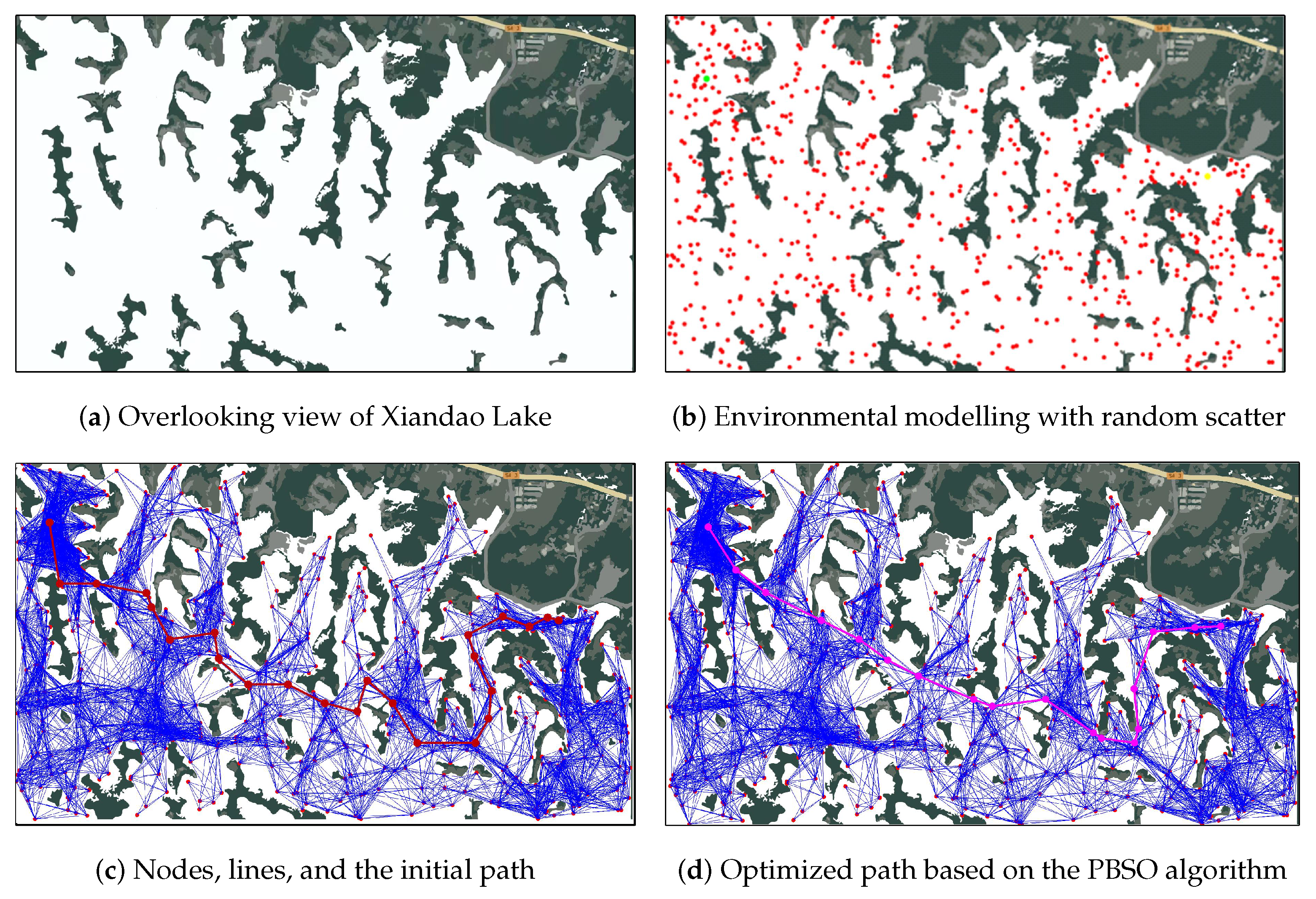
5.3. Real Case Experiments

While the simulation experiments described above can provide a quantitative assessment of the algorithm’s performance, real case experiments can validate the algorithm’s performance. Because real marine environments can be more complex than simulation environments, we designed a geographic information system (GIS)-based simulated map experiment. This experiment uses real geographic data to evaluate the performance of the algorithm in a specific geographic environment. We chose Xiandao Lake in China as the experimental environment to design a case study experiment for unmanned boat path optimization planning. Xiandao Lake, also often referred to as Yangxin Xiandao Lake or Thousand Island Lake, is located in Yangxin County, Hubei Province, China. The specific latitude and longitude coordinates are 29.74° N and 115.43° E, respectively. It is a large reservoir consisting of several islands, and its exact boundaries and island locations are shown in Figure 5a. We randomly placed 500 points on the map; the locations of these points are all within the navigable area of the USV, and the distribution of the scattered points is shown as the red points in Figure 5b. The start and target points of the route planning task are shown as green and yellow points in Figure 5b, respectively. A total of 8973 link lines are generated on the basis of the randomly distributed scatter points, which satisfy the relevant constraints, i.e., the link line between two points does not pass through any islands or obstacles, and these link lines are represented by blue lines in Figure 5c. Based on the distribution of link lines, an initial reachable path can be planned, which is represented by the red line in Figure 5c. Finally, the initial path is optimized via the PBSO enhanced path planning algorithm proposed in this paper, and the optimized result is shown by the red line in Figure 5d.
According to the above results of the Xiandao Lake case, the use of this method can successfully find the optimal path in a complex water environment. The PBSO algorithm is used to find the optimal path length of 5.285 km; the number of turns is 15, and the total angle of the turn is 389.766°. Because of the complexity of the obstacles and islands in the real environment, although we did not calculate the average distance of the obstacles according to Equation (8), the optimized route is farther from the obstacles or islands from the observation of the results. The experimental results show that our proposed enhanced path planning algorithm is effective and feasible for application to other complex environment path planning scenarios, such as tourist attraction path planning.

6. Conclusions

We propose an unmanned boat path optimization algorithm based on the PBSO algorithm and apply it to complex water environments, such as Xiandao Lake. Through an in-depth study of the unmanned boat path planning problem, we not only propose an effective path optimization strategy but also develop a comprehensive assessment system for evaluating the performance of the path. The PRM method is first used to model complex water environments such as Thousand Island Lake; this method effectively handles the environmental characteristics of multiple islands and obstacles and provides an accurate environmental model for path planning. This study also proposes four evaluation metrics, including path length, number of turns, turn angle, and distance from obstacles, which provide quantitative evaluation criteria for unmanned vessel path planning. The PBSO-based path planning method proposed in this paper significantly improves the algorithm’s global search capability and local optimal escape capability in high-dimensional space by simulating the social behaviours of the barracuda population and utilizing the innovative pair barracuda strategy and deep memory mechanism. The effectiveness, stability, and superiority of the proposed algorithm are verified by conducting many experiments in both a simulated Thousand Island Lake environment and in Thousand Island Lake. The experimental results show that the PBSO-based path planning method can identify the optimal path faster and has better stability and seaworthiness than the existing heuristic path planning methods. This study achieved good results in complex water environments, such as Thousand Island Lake, and the algorithm can be applied to a wider range of real scenarios, such as maritime transport and search and rescue missions, to verify its applicability and robustness in different environments. Future research can consider the impact of USV path planning on the real-world environment, such as the avoidance of dynamic obstacles and ecological protection areas, to achieve a more environmentally friendly and sustainable path planning strategy.

Author Contributions

B.S.: Conceptualization, data curation, formal analysis, investigation, methodology, funding acquisition, validation, visualization, writing—original draft, writing—review and editing. Z.L.: Conceptualization, resources, software, funding acquisition, writing—review and editing. Z.H.: Conceptualization, resources, software, funding acquisition, writing—review and editing. C.W.: Measurement, investigation, methodology, software. J.G.: Conceptualization, formal analysis, funding acquisition, methodology, project administration, resources, software, supervision, writing—review and editing. All authors have read and agreed to the published version of the manuscript.

Funding

This study was supported by the Natural Science Foundation of China (No. 52201363), the Natural Science Foundation of Hubei Province (Nos. 2023AFB562, 2023AFB003, 2022CFB076), the Hubei Provincial Education Department Scientific Research Program Project (Nos. Q20222202, Q20212204), and the Ideological and Political Department Project of Hubei Province (No. 21Q210).

Institutional Review Board Statement

Not applicable.

Informed Consent Statement

Not applicable.

Data Availability Statement

The datasets generated and analyzed during this study are available from the corresponding author upon request.

Acknowledgments

We thank Hubei University of Economics for their support.

Conflicts of Interest

The authors declare no conflicts of interest. The funders had no role in the design of this study; in the collection, analyses, or interpretation of data; in the writing of the manuscript; or in the decision to publish the results.

References

  1. Cohen, S.A.; Hopkins, D. Autonomous vehicles and the future of urban tourism. Ann. Tour. Res. 2019, 74, 33–42. [Google Scholar] [CrossRef]
  2. Xu, X.; Zeng, J.; Zhao, Y.; Lü, X. Research on global path planning algorithm for mobile robots based on improved A. Expert Syst. Appl. 2023, 243, 122922. [Google Scholar] [CrossRef]
  3. Yu, K.; Liang, X.F.; Li, M.Z.; Chen, Z.; Yao, Y.L.; Li, X.; Zhao, Z.X.; Teng, Y. USV path planning method with velocity variation and global optimisation based on AIS service platform. Ocean Eng. 2021, 236, 109560. [Google Scholar] [CrossRef]
  4. Sang, H.; You, Y.; Sun, X.; Zhou, Y.; Liu, F. The hybrid path planning algorithm based on improved A* and artificial potential field for unmanned surface vehicle formations. Ocean Eng. 2021, 223, 108709. [Google Scholar] [CrossRef]
  5. Xie, L.; Xue, S.; Zhang, J.; Zhang, M.; Tian, W.; Haugen, S. A path planning approach based on multi-direction A* algorithm for ships navigating within wind farm waters. Ocean Eng. 2019, 184, 311–322. [Google Scholar] [CrossRef]
  6. Wang, S.; Fu, M.; Wang, Y.; Zhao, L. A multi-layered potential field method for waterjet propelled unmanned surface vehicle local path planning with minimum energy consumption. Pol. Marit. Res. 2019, 26, 134–144. [Google Scholar] [CrossRef]
  7. Fan, X.; Guo, Y.; Liu, H.; Wei, B.; Lyu, W. Improved artificial potential field method applied for AUV path planning. Math. Probl. Eng. 2020, 2020, 6523158. [Google Scholar] [CrossRef]
  8. Yan, X.P.; Wang, S.W.; Ma, F.; Liu, Y.C.; Wang, J. A novel path planning approach for smart cargo ships based on anisotropic fast marching. Expert Syst. Appl. 2020, 159, 113558. [Google Scholar] [CrossRef]
  9. Chen, Z.; Zhang, Y.; Zhang, Y.; Nie, Y.; Tang, J.; Zhu, S. A hybrid path planning algorithm for unmanned surface vehicles in complex environment with dynamic obstacles. IEEE Access 2019, 7, 126439–126449. [Google Scholar] [CrossRef]
  10. Hu, L.; Naeem, W.; Rajabally, E.; Watson, G.; Mills, T.; Bhuiyan, Z.; Raeburn, C.; Salter, I.; Pekcan, C. A multiobjective optimization approach for COLREGs-compliant path planning of autonomous surface vehicles verified on networked bridge simulators. IEEE Trans. Intell. Transp. Syst. 2019, 21, 1167–1179. [Google Scholar] [CrossRef]
  11. Zhao, L.; Bai, Y.; Paik, J.K. Global-local hierarchical path planning scheme for unmanned surface vehicles under dynamically unforeseen environments. Ocean Eng. 2023, 280, 114750. [Google Scholar] [CrossRef]
  12. Öztürk, Ü.; Akdağ, M.; Ayabakan, T. A review of path planning algorithms in maritime autonomous surface ships: Navigation safety perspective. Ocean Eng. 2022, 251, 111010. [Google Scholar] [CrossRef]
  13. Guo, J.; Zhou, G.; Yan, K.; Sato, Y.; Di, Y. Pair barracuda swarm optimization algorithm: A natural-inspired metaheuristic method for high dimensional optimization problems. Sci. Rep. 2023, 13, 18314. [Google Scholar] [CrossRef] [PubMed]
  14. Liu, S.; Wu, H. Analysis of the application of path finding system based on efficiency improvement in smart tourism. Intell. Syst. Appl. 2023, 20, 200265. [Google Scholar] [CrossRef]
  15. Niu, H.; Lu, Y.; Savvaris, A.; Tsourdos, A. An energy-efficient path planning algorithm for unmanned surface vehicles. Ocean Eng. 2018, 161, 308–321. [Google Scholar] [CrossRef]
  16. Niu, H.; Lu, Y.; Savvaris, A.; Tsourdos, A. Efficient path planning algorithms for unmanned surface vehicle. IFAC-PapersOnLine 2016, 49, 121–126. [Google Scholar] [CrossRef]
  17. Bai, X.; Li, B.; Xu, X.; Xiao, Y. USV path planning algorithm based on plant growth. Ocean Eng. 2023, 273, 113965. [Google Scholar] [CrossRef]
  18. Hao, S.; Ma, W.; Han, Y.; Zheng, H.; Ma, D. Optimal path planning of unmanned surface vehicle under current environment. Ocean Eng. 2023, 286, 115591. [Google Scholar] [CrossRef]
  19. Song, Z.; Zhang, J.; Wu, D.; Tian, W. A novel path planning algorithm for ships in dynamic current environments. Ocean Eng. 2023, 288, 116091. [Google Scholar] [CrossRef]
  20. Petres, C.; Pailhas, Y.; Patron, P.; Petillot, Y.; Evans, J.; Lane, D. Path planning for autonomous underwater vehicles. IEEE Trans. Robot. 2007, 23, 331–341. [Google Scholar] [CrossRef]
  21. Wang, N.; Jin, X.; Er, M.J. A multilayer path planner for a USV under complex marine environments. Ocean Eng. 2019, 184, 1–10. [Google Scholar] [CrossRef]
  22. Gu, Q.; Zhen, R.; Liu, J.; Li, C. An improved RRT algorithm based on prior AIS information and DP compression for ship path planning. Ocean Eng. 2023, 279, 114595. [Google Scholar] [CrossRef]
  23. Zhang, X.; Wang, C.; Liu, Y.; Chen, X. Decision-making for the autonomous navigation of maritime autonomous surface ships based on scene division and deep reinforcement learning. Sensors 2019, 19, 4055. [Google Scholar] [CrossRef] [PubMed]
  24. Wang, Y.; Lu, C.; Wu, P.; Zhang, X. Path planning for unmanned surface vehicle based on improved Q-Learning algorithm. Ocean Eng. 2024, 292, 116510. [Google Scholar] [CrossRef]
  25. Yoo, B.; Kim, J. Path optimization for marine vehicles in ocean currents using reinforcement learning. J. Mar. Sci. Technol. 2016, 21, 334–343. [Google Scholar] [CrossRef]
  26. Chen, M.; Zhu, D. Optimal time-consuming path planning for autonomous underwater vehicles based on a dynamic neural network model in ocean current environments. IEEE Trans. Veh. Technol. 2020, 69, 14401–14412. [Google Scholar] [CrossRef]
  27. Alvarez, A.; Caiti, A.; Onken, R. Evolutionary path planning for autonomous underwater vehicles in a variable ocean. IEEE J. Ocean. Eng. 2004, 29, 418–429. [Google Scholar] [CrossRef]
  28. Witt, J.; Dunbabin, M. Go with the flow: Optimal AUV path planning in coastal environments. In Proceedings of the Australian Conference on Robotics and Automation, Canberra, Australia, 3–5 December 2008. [Google Scholar]
  29. Lyridis, D.V. An improved ant colony optimization algorithm for unmanned surface vehicle local path planning with multi-modality constraints. Ocean Eng. 2021, 241, 109890. [Google Scholar] [CrossRef]
  30. Kennedy, J.; Eberhart, R. Particle swarm optimization. In Proceedings of the ICNN’95—International Conference on Neural Networks, Perth, Australia, 27 November–1 December 1995; pp. 1942–1948. [Google Scholar]
  31. Liang, X.; Li, W.; Zhang, Y.; Zhou, M. An adaptive particle swarm optimization method based on clustering. Soft Comput. 2015, 19, 431–448. [Google Scholar] [CrossRef]
  32. Xu, Y.; Pi, D. A reinforcement learning-based communication topology in particle swarm optimization. Neural Comput. Appl. 2020, 32, 10007–10032. [Google Scholar] [CrossRef]
  33. Guo, J.; Sato, Y. A pair-wise bare bones particle swarm optimization algorithm. In Proceedings of the 2017 IEEE/ACIS 16th International Conference on Computer and Information Science, Wuhan, China, 24–26 May 2017; pp. 353–358. [Google Scholar]
  34. Li, J.; Wan, L.; Huang, Z.; Chen, Y.; Tang, H. Hybrid Path Planning Strategy Based on Improved Particle Swarm Optimisation Algorithm Combined with DWA for Unmanned Surface Vehicles. J. Mar. Sci. Eng. 2024, 12, 1268. [Google Scholar] [CrossRef]
  35. Chen, G.; Luo, N.; Liu, D.; Zhao, Z.; Liang, C. Path planning for manipulators based on an improved probabilistic roadmap method. Robot. Comput.-Integr. Manuf. 2021, 72, 102196. [Google Scholar] [CrossRef]
  36. Guo, J.; Sato, Y. A Bare Bones Particle Swarm Optimization Algorithm with Dynamic Local Search. In Proceedings of the Advances in Swarm Intelligence: 8th International Conference, Fukuoka, Japan, 27 July–1 August 2017; pp. 158–165. [Google Scholar]
  37. Xiao, H.; Guo, J.; Shi, B.; Di, Y.; Pan, C.; Yan, K.; Sato, Y. A Twinning Memory Bare-Bones Particle Swarm Optimization Algorithm for No-Linear Functions. IEEE Access 2023, 11, 25768–25785. [Google Scholar] [CrossRef]
  38. Zhong, C.; Li, G.; Meng, Z. Beluga whale optimization: A novel nature-inspired metaheuristic algorithm. Knowl.-Based Syst. 2022, 251, 109215. [Google Scholar] [CrossRef]
  39. Sun, Y.; Guo, J.; Yan, K.; Di, Y.; Pan, C.; Shi, B.; Sato, Y. A deep memory bare-bones particle swarm optimization algorithm for single-objective optimization problems. PLoS ONE 2023, 18, e0284170. [Google Scholar] [CrossRef] [PubMed]
  40. Guo, J.; Zhou, G.; Di, Y.; Shi, B.; Yan, K.; Sato, Y. A Bare-Bones Particle Swarm Optimization with Crossed Memory for Global Optimization. IEEE Access 2023, 11, 31549–31568. [Google Scholar] [CrossRef]
Figure 1. Environment modelling flowchart path planning problem.
Jmse 12 02189 g001
Figure 2. Path optimization process.
Jmse 12 02189 g002
Figure 3. Comparison of path planning.
Jmse 12 02189 g003
Figure 4. Comparison of fitness curves.
Jmse 12 02189 g004
Figure 5. Results of enhanced path planning.
Jmse 12 02189 g005
Table 1. Environmental parameter settings.
ParametersMap1Map2Map3Map4
Map size (unit: km)6 × 610 × 610 × 10100 × 100
Number of obstacles251030
Starting point location[4, 1][4, 1][7, 1][4, 1]
Target point location[1.5, 5.9][1.5, 8.9][1.5, 8.9][91.5, 89.9]
Number of particle swarms100100100100
Iterations500500500500
Table 2. Comparison experiments with state-of-the-art nature-inspired methods.
ParametersUnitPSOBBPSOTMBBPSOWOADMBBPSOCM-BBPSOPBSO
Map1TNDkm5.5175.5105.5115.5106.4045.5105.510
NT4222322
ATA° 27.82514.33214.30813.68478.93313.77113.483
MSDkm1.6951.8642.0861.5832.2151.7422.083
Map2TNDkm9.4838.3498.3488.3489.1558.3488.348
NT5224222
ATA° 240.16323.53122.40823.55663.52922.92348.683
MSDkm2.8322.8463.3562.7513.5222.6133.798
Map3TNDkm10.5429.7179.7189.7189.7189.7189.716
NT5332222
ATA° 151.60717.33716.98616.69916.91717.11217.159
MSDkm3.6384.7733.3674.2243.7214.2804.833
Map4TNDkm143.753151.229150.961126.614128.218128.071126.454
NT5334333
ATA° 302.49584.32583.07363.09073.61356.30251.292
MSDkm3.7535.3375.2673.7795.0093.9455.616
The bold data indicate the best values of the parameters under the same conditions.
Disclaimer/Publisher’s Note: The statements, opinions and data contained in all publications are solely those of the individual author(s) and contributor(s) and not of MDPI and/or the editor(s). MDPI and/or the editor(s) disclaim responsibility for any injury to people or property resulting from any ideas, methods, instructions or products referred to in the content.

