Article

Navigability of Liquefied Natural Gas Carriers Along the Northern Sea Route

1
Naval Architecture and Shipping College, Guangdong Ocean University, Zhanjiang 524088, China
2
Key Laboratory of Philosophy and Social Science in Hainan Province of Hainan Free Trade Port International Shipping Development and Property Digitization, Hainan Vocational University of Science and Technology, Haikou 570100, China
3
Guangdong Provincial Engineering Research Center for Ship Intelligence and Safety, Guangdong Ocean University, Zhanjiang 524088, China
4
Guangdong Provincial Key Laboratory of Intelligent Equipment for South China Sea Marine Ranching, Guangdong Ocean University, Zhanjiang 524088, China
5
Shenzhen Institute of Guangdong Ocean University, Shenzhen 518116, China
6
Merchant Marine College, Shanghai Maritime University, Shanghai 201306, China
*
Authors to whom correspondence should be addressed.
J. Mar. Sci. Eng. 2024, 12(12), 2166; https://doi.org/10.3390/jmse12122166
Submission received: 15 October 2024 / Revised: 16 November 2024 / Accepted: 26 November 2024 / Published: 27 November 2024
(This article belongs to the Section Ocean Engineering)

Abstract

:
As Arctic sea ice continues to melt and global demand for clean energy rises, Russia’s Liquefied Natural Gas (LNG) exports via the Northern Sea Route (NSR) are rapidly increasing. To ensure the operational safety of LNG carriers and safeguard the economic interests of stakeholders, including shipowners, a thorough assessment of the navigability of various ice-class LNG carriers along this route is essential. This study collected Arctic ice condition data from 2014 to 2023 and applied the Polar Operational Limit Assessment Risk Indexing System (POLARIS) methodology to calculate the Risk Index Outcome (RIO) for LNG carriers with No Ice Class, Arc4, and Arc7 ice classifications in Arctic waters. A navigability threshold of 95% RIO ≥ 0 was established to define navigable windows, and critical waters were identified where sections of the route remain in hazardous or risky conditions year-round. The results indicate that for No Ice Class vessels, Arc4 vessels, and Arc7 vessels, the navigable windows for westbound Route 1 and Route 2 under light, normal, and heavy ice conditions range from 70 to 133 days, 70 to 365 days, and 70 to 365 days, respectively, while for eastbound Route 3, the navigable windows range from 0 to 84 days, 0 to 238 days, and 7 to 365 days, respectively. The critical waters affecting the navigability of No Ice Class vessels, Arc4 vessels, and Arc7 vessels are primarily located in the Kara Sea, Laptev Sea and East Siberian Sea. This study, using the POLARIS methodology, provides valuable insights into the navigability of LNG carriers with different ice classes along the NSR, supporting the development and utilization of Arctic energy and shipping routes while offering decision-making support for stakeholders involved in Arctic maritime operations.

1. Introduction

Global warming has caused a decreasing trend in the extent and thickness of Arctic sea ice, facilitating energy transport in the Arctic region to some degree. However, sea ice conditions continue to pose significant challenges to the safety of ship operations. Liquefied Natural Gas (LNG) transport has gradually increased since the first phase of Russia’s Yamal LNG project commenced operations in 2017 [1]. The reports of the Northern Sea Route (NSR) by the Northern Sea Route Administration (NSRA) [2,3,4] show the following: (1) From 2020 to 2022, LNG carriers consistently held the largest share of gross registered tonnage (GRT) among all vessel types operating on the NSR, accounting for 63.65%, 69.91%, and 65.59%, respectively. They ranked first in terms of GRT for three consecutive years. (2) The number of LNG carrier transit voyages on the NSR from 2020 to 2022 was 510, 528, and 564, respectively, indicating a year-on-year increase. This indicates that the scale of LNG transport on the NSR is gradually expanding, both in terms of gross registered tonnage (GRT) and voyages, and suggests that the NSR may be evolving into a potential energy transport corridor. Currently, LNG carriers operating in the NSR include the following ice classes: Arc7, Arc4 and No Ice Class. According to the Rules of Navigation in the Water Area of the Northern Sea Route [5], Arc4 vessels and Arc7 vessels are capable of operating year-round under light ice conditions, while No Ice Class vessels are limited to operating from July 1 to October 15 with icebreaker escorts. As the climate warms, the NSR will experience dynamic changes in navigable windows and sea ice conditions in critical waters. Even Arc7 vessels operating year-round may still require icebreaker escorts in certain years or waters [6]. As the demand for clean energy continues to grow in the international market, the GRT and voyage frequency of LNG carriers in the NSR may further increase, raising concerns among stakeholders regarding the potential operational risks of the NSR.
The navigability of waters in ice-covered regions primarily depends on sea ice regimes and the ice resistance of the ship, with a focus on assessing the risks associated with vessel operations in such environments. Liu et al. [7] selected specific ice class vessels and studied the navigability of PC6 vessels in the Northwest Passage (NWP) based on their ability to navigate through particular sea ice concentrations. Lei et al. [8] indicated that the navigable period for PC6 vessels in the NSR increased from 84 days in 1980 to 114 days in 2000 and further expanded to 146 days by 2012. The NSRA [5] divides the NSR into 28 districts, defining the navigability of vessels with different ice classes under various sea ice conditions within each district. The Canadian-developed ARISS system [9] calculates the Ice Numeral in icy waters based on the ice regime and vessel ice class, determining whether the vessel should proceed or take an alternative route. The International Maritime Organization (IMO) developed the Polar Operational Limit Assessment Risk Indexing System (POLARIS) methodology by drawing on the Arctic shipping management experiences and related methods from Russia, Canada, and other regions [10]. This methodology utilizes RIO to comprehensively assess the ice class of vessels and sea ice conditions in navigable waters, evaluating the operational risks for vessels navigating in icy regions, which has attracted attention from scholars. The POLARIS methodology is an effective risk-based decision-support tool that not only assists vessel operators in voyage planning but also helps vessel owners select suitable ice class vessels for route design. Additionally, it complies with the safety navigation requirements of coastal states, coast guard agencies, classification societies, and underwriters [11]. Bond et al. [12] used the POLARIS methodology to explore the feasibility of the NWP Route as an export for North American resources, selecting PC3 vessels, PC4 vessels, and PC5 vessels to study the navigable windows of various routes. Chen et al. [13] analyzed the navigability of PC3 vessels, PC7 vessels, and OW vessels in the NSR and the NWP under global warming conditions of 1.5 °C, using Coupled Model Intercomparison Project Phase 6 (CMIP6) data, which was based on the POLARIS methodology. An et al. [14] used the POLARIS methodology to study the navigable window of IA vessels in the NSR under different sea ice conditions. They found that the navigable periods were 91 days under normal ice conditions and 175 days under light ice conditions; however, only the 40th week of the year was deemed suitable for navigation under heavy ice conditions.
Currently, there are relatively few studies on the navigability of LNG carriers in icy waters. Chen et al. [15] examined the sea ice regimes during the first commercial voyage of an Arc7 Ice Class LNG carrier in the winter of 2021. They employed the CMIP6 model to predict sea ice changes and assess the navigability of Arc7 vessels in the NSR from January to June between 2021 and 2050, concluding that navigation along the NSR in winter remains fraught with risk for these vessels. Other studies [16,17] consider factors such as human elements, vessels, and environmental conditions, using models to assess the risks associated with the NSR. However, they do not provide support for vessel operations along the route. Overall, there is an urgent need for the development and transportation of LNG in the Arctic to mitigate the risks associated with ship operations in the ice region of the NSR. On the one hand, the warming climate has raised expectations for navigation, and the navigable windows of the routes, along with the risks posed by sea ice conditions, are dynamically changing. On the other hand, LNG carriers operating in the NSR include a variety of ice class vessels, and the operational risks faced by vessels under the same ice conditions vary, necessitating systematic research.
This study focuses on LNG carriers of different ice classes operating in the NSR and examines eastward and westward routes for these vessels. Based on ice condition data from 2014 to 2023, the POLARIS methodology is used to obtain the RIO of vessels of different ice classes on this route and to analyze the navigable windows of LNG carriers of various ice classes, as well as the critical waters affecting their safety. This comprehensive understanding of LNG carriers’ navigability in the NSR will support the development and utilization of the Arctic energy corridor and provide a crucial basis for decision-making related to the socio-economic activities of Arctic stakeholders. At the same time, this study responds to the IMO’s proposal that “POLARIS should be updated in light of subsequent experience [10]”.

2. Study Area and Data

2.1. Study Area

The Yamal LNG project, one of the largest LNG projects in the world, is situated at the port of Sabetta in Russia. Therefore, Sabetta serves not only as a significant Liquefied Natural Gas production hub but also as a deep-water port that facilitates LNG transportation in extreme climate conditions. Consequently, this study analyzed three routes from Sabetta through the NSR for LNG exports to Europe and Asia (Figure 1). All three routes start from Sabetta but have different endpoints, with Route 1 and Route 2 leading to Europe as Russian LNG export routes to the west, while Route 3 leads to Asia as a Russian LNG export route to the east. Route 1 ends in the Kara Strait, Route 2 ends in the northeastern corner of Novaya Zemlya, and Route 3 ends in the Bering Strait. The route passes through the Chukchi Sea, the East Siberian Sea, the Laptev Sea, and the Kara Sea [18,19]. The Barents Sea remains open almost year-round due to the warm North Atlantic Current, which prevents complete freezing of the sea [8,20]. In contrast, navigable conditions in the Kara, Laptev, and East Siberian Seas are more challenging [8]. Therefore, instead of opting for the navigable route via the Barents Sea, the study selected Kara Strait as the terminus for Route 1 and Route 2 for LNG exports to Europe.

2.2. Research Data

The study obtained sea ice regime data covering the Arctic waters from 2014 to 2023, sourced from the U.S. National Ice Centre (USNIC) [21], in SIGRID-3 format [22] (Figure 2), with the WGS 1984 Stereographic North Pole coordinate system. The three routes operated by LNG carriers are in the form of vector data, using the Lambert Azimuthal Equal Area Projection coordinate system.

3. Methodology and Technical Roadmap

3.1. POLARIS

The POLARIS methodology assigns a Risk Index Value (RIV) to vessels based on their ice class and sea ice conditions, evaluating operational risk through the calculation of the Risk Index Outcome (RIO) [10].

3.1.1. Risk Index Values and Sea Ice Concentrations

(1)
Risk Index Values
The RIVs are determined by the sea ice stage of development and the ice class of vessels. The sea ice stage of development includes the stage of development of the thickest ice (SA), the stage of development of the second thickest ice (SB), and the stage of development of the third thickest ice (SC) [22]. The ice class of vessels (Table 1) is based on a combination of IACS Polar Ice Class and equivalent ice classes from the Finnish–Swedish Ice Class Rules, which aligns with the ice classes referenced in the Polar Code [23,24].
From Table 1, it can be observed that RIVs (Risk Index Values) range from −8 to +3, reflecting the level of risk associated with navigating through specific types of sea ice. A negative RIV indicates a high navigation risk, making it unsuitable for vessels of that ice class, while a positive RIV suggests that navigation is feasible; the higher the value, the lower the navigation risk [25]. For a given ice class vessel, its RIVs in ice-covered areas with different sea ice types can be found in Table 1. In this study, the Arc4 vessels correspond to the PC7 vessels, while the Arc7 vessels correspond to the PC4 vessels [26,27].
Table 1. Risk Index Values.
Ice ClassIFNGGWTNFY1TNFY2MFY-1MFYTKFYSYLMY-2.5HMY
PC1333322222211
PC2333322222110
PC333332222210−1
PC4 (Arc7)3333222210−1−2
PC5333322110−1−2−2
PC632232110−1−2−3−3
PC7 (Arc4)3222110−1−2−3−3−3
IA Super3222210−1−2−3−4−4
IA322210−1−2−3−4−5−5
IB32210−1−2−3−4−5−6−6
IC3210−1−2−3−4−5−6−7−8
No Ice Class310−1−2−3−4−5−6−7−8−8
Note: IF—ice-free; N—new ice; G—grey ice; GW—grey white ice; TNFY1—thin first-year Ice, 1st stage; TNFY2— thin first-year Ice, 2nd stage; MFY-1—medium first-year Ice, less than 1 m thick; MFY—medium first-year ice; TKFY—thick first-year Ice; SY—second-year Ice; LMY-2.5—light multi-year ice, less 2.5 m thick; HMY—heavy multi-year ice [10,28].
(2)
Sea ice concentrations
This study utilized sea ice condition data to provide information on sea ice concentration. This encompasses the fields Total Concentration (CT), partial concentration of thickest ice (CA), partial concentration of second thickest ice (CB), and partial concentration of the third thickest ice (CC), with sea ice concentration being expressed in tenths [22].

3.1.2. Risk Index Outcome

The Risk Index Outcome (RIO) is derived from the Risk Index Value (RIV) and sea ice concentration to assess limitations for operation in ice. The RIO is determined by summing the RIVs for each ice type present in the ice regime multiplied by its concentration (expressed in tenths) [10]:
R I O = ( C 1 × R I V 1 ) + ( C 2 × R I V 2 ) + ( C 3 × R I V 3 ) + + ( C n × R I V n )
where C1…Cn are the concentrations (in tenths) of ice types within the sea ice regime, and RIV1…RIVn are the corresponding Risk Index Values for each ice type.

3.1.3. Evaluation of Risk Index Outcome

POLARIS addresses three levels of operation (Table 2) based on RIO values: normal operations (RIO ≥ 0), elevated operational risk (−10 ≤ RIO < 0), and operation subject to special consideration (RIO < −10) [10]. These categories assume that seafarers navigating in ice-covered regions exercise appropriate caution and account for changing conditions, namely weather and visibility.

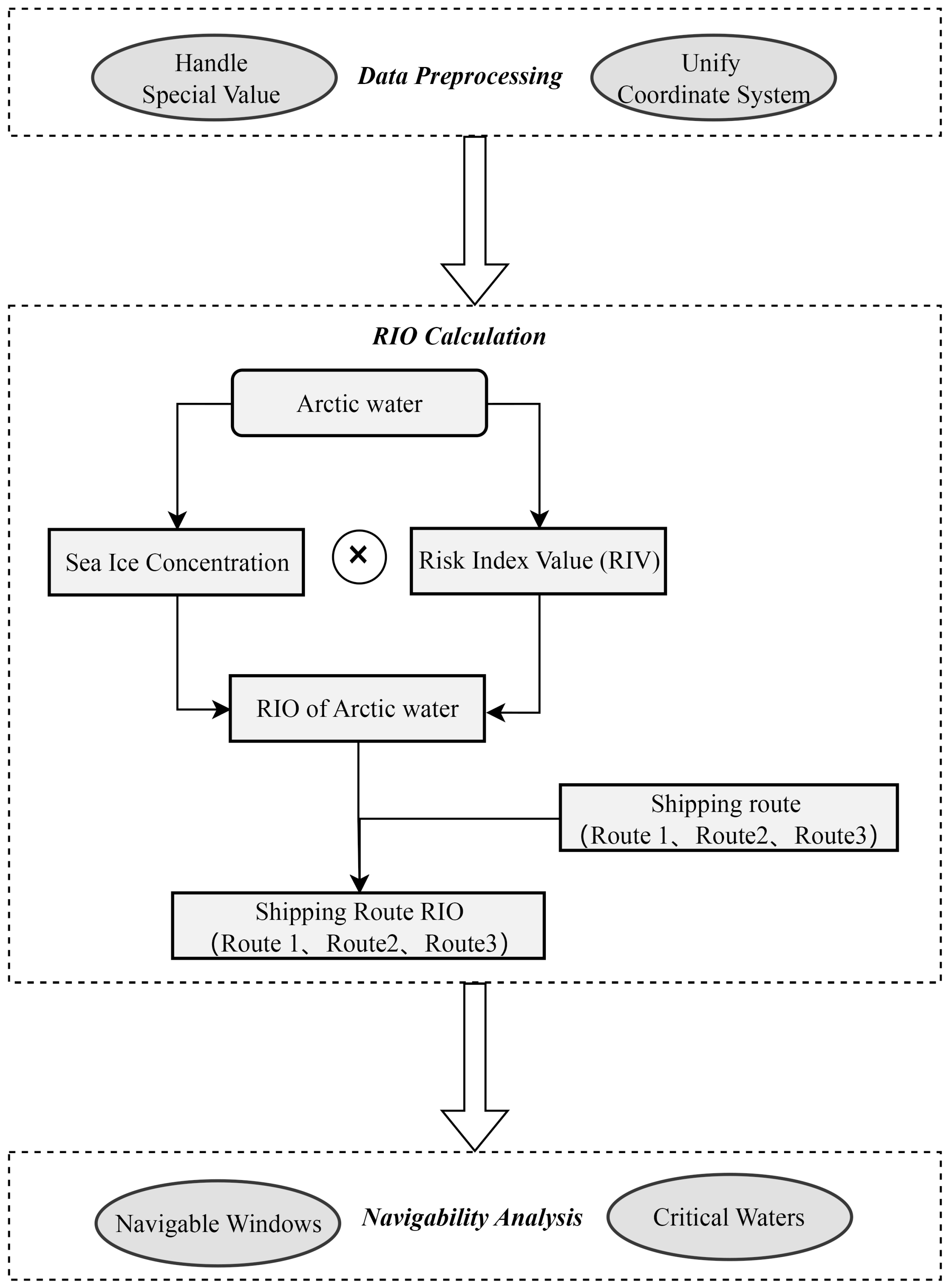
3.2. Data Processing Method

The technical roadmap of this study is composed of three components: data preprocessing, RIO calculation, and navigability analysis (Figure 3).
(1)
Data preprocessing mainly involves two key tasks. One is to address the processing of null values and other special values within the sea ice condition data; the other is to unify the coordinate system. The WGS 1984 Stereographic North Pole coordinate system is utilized for the NSR and sea ice condition data.
(2)
The RIO calculation is split into two parts: the RIO calculation for Arctic waters and the RIO calculation for the shipping routes. The RIO for Arctic waters is primarily calculated by weighting and summing the RIVs in relation to sea ice concentration. The calculation of the NSR RIO is accomplished through a spatial overlay operation, which extracts the RIO value at the shipping route location from the RIO for Arctic waters. This process counts the minimum, average, and maximum values of the NSR RIO based on data obtained from each week over a 10-year period from 2014 to 2023.
(3)
The navigability analysis focuses on Arc7 vessels, Arc4 vessels, and No Ice Class vessels, primarily examining their navigable windows on the NSR (Route 1, Route 2, and Route 3) and identifying critical waters that impact operational safety. By analyzing navigable windows, we determine the navigable windows for different ice class vessels. Additionally, based on the identification of risky waters and hazardous waters, we have identified critical waters with higher risks and complex ice conditions for vessels of different ice classes on the route.

4. Operational Risks in the NSR

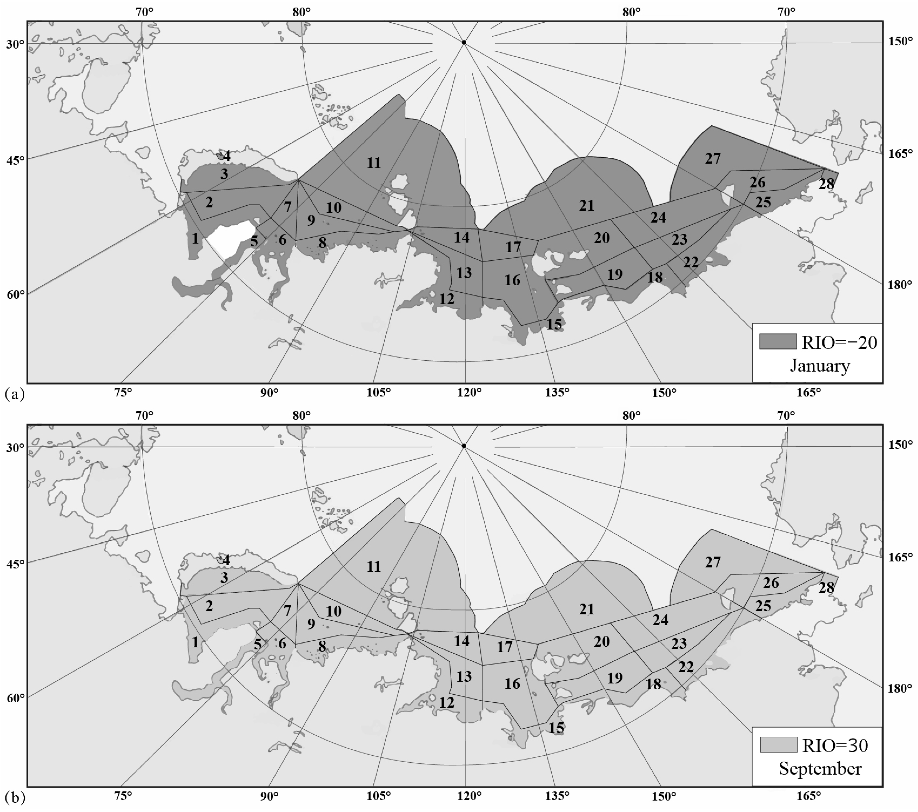
4.1. RIO in the NSR Waters

The waters of the NSR are defined based on 28 navigable districts established by the NSRA. To exemplify the technical roadmap of the study, Arc4 vessels were chosen as examples for both poor sea ice conditions [15,30] and better sea ice conditions [30,31]. The RIOs for the NSR were calculated for January and September using spatial overlay analysis with both Arctic waters and the NSR waters (Figure 4).
Figure 4 illustrates the changes in RIO for Arc4 vessels navigating the NSR during the winter and summer of 2014. Specifically, Figure 4a illustrates the RIO for Arc4 vessels within the NSR at the end of January 2014, whereas Figure 4b shows the RIO for these vessels in the NSR waters in mid-September 2014. At the end of January 2014, the RIO value for Arc4 vessels was −20 (Figure 4), indicating high-risk operations (RIO < −10). Under such conditions, the speed of vessels should be limited to 3 knots (unless reducing speed compromises the vessel’s maneuverability), and additional lookout duty or icebreaker support should be utilized. In contrast, by mid-September 2014, the RIO for Arc4 vessels was 30, enabling normal operations. This comparison highlights the significant variations in sea ice conditions in the NSR waters across different months and the operational risks that vessels encounter in these regions.

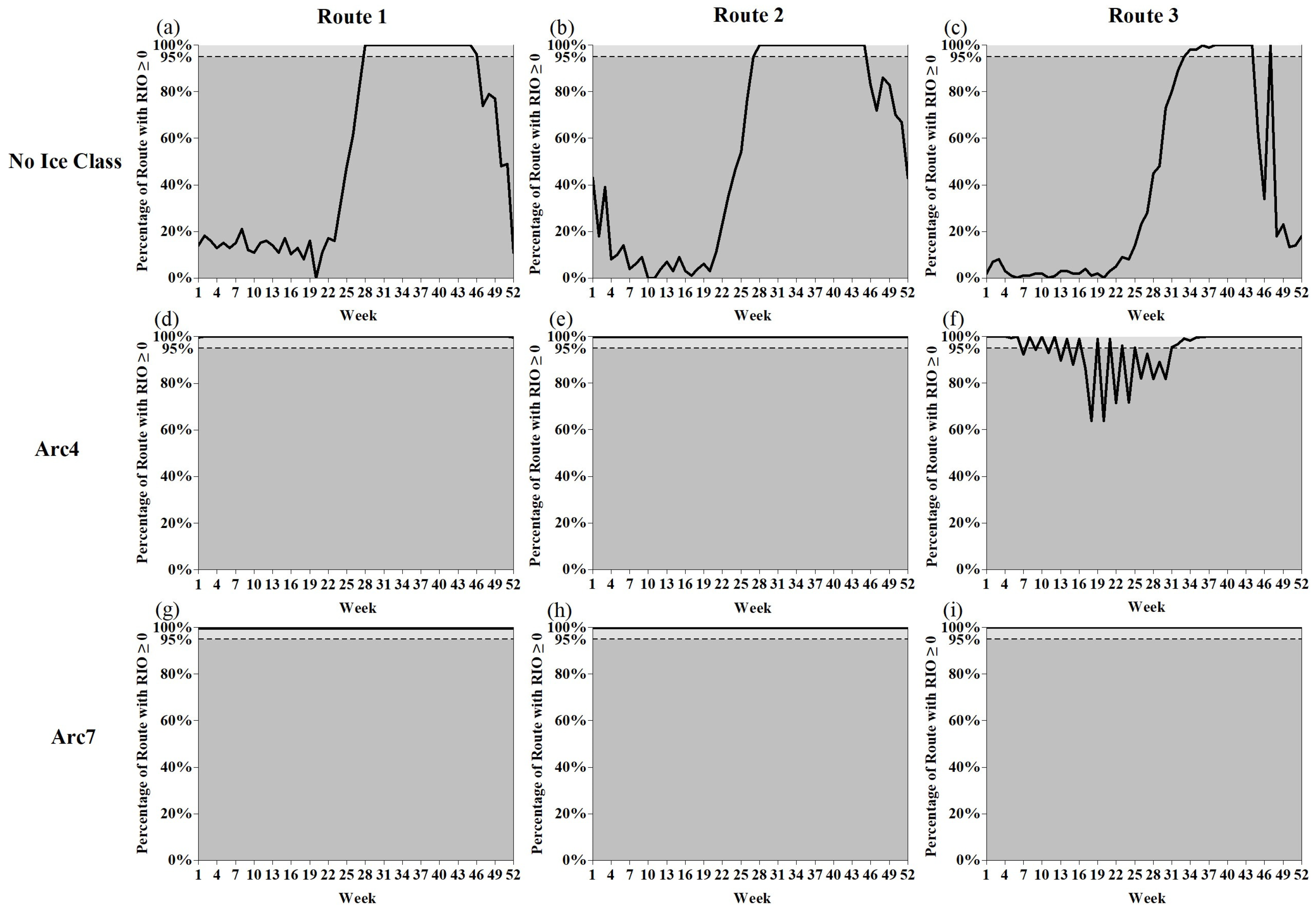
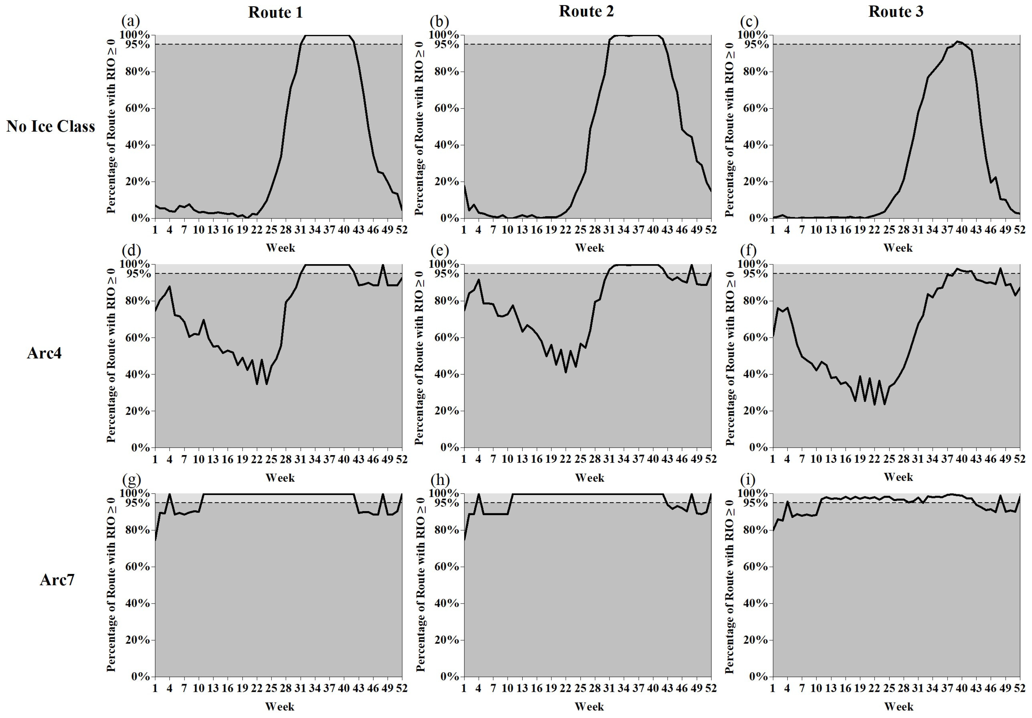
4.2. Navigable Windows for LNG Carriers Under Different Sea Ice Conditions

The navigable windows refer to the start time, end time, and duration of the period during which sea ice conditions do not hinder the safe passage of vessels through the waters [33]. In this study, a navigability threshold of 95% of segments with an RIO ≥ 0 was selected for LNG carriers of No Ice Class, Arc4 Ice Class, and Arc7 Ice Class operating on the NSR [14]. In this study, we define years with light ice conditions, normal ice conditions, and heavy ice conditions based on the RIO value. For a year with light ice conditions, we to determine the RIO value for a specific location on the route over a decade (i.e., 10 RIO values), and choose the maximum RIO (MaxRIO) as the RIO value for that location. Similarly, for a year with heavy ice conditions, we determine the RIO value for that location over a decade, and choose the minimum RIO (MinRIO) as the RIO for that location. For a year with normal ice conditions, we determine the RIO value for that location over a decade, and choose the average RIO (MeanRIO) as the RIO for that location. These values also facilitated the analysis of the navigable windows for No Ice Class, Arc4 Ice Class, and Arc7 Ice Class LNG carriers in the NSR under varying sea ice conditions. Figure 5, Figure 6 and Figure 7 illustrate the weekly proportion of RIO ≥ 0 for LNG carriers navigating the shipping routes (Route 1, Route 2 and Route 3), categorized by different vessel ice classes and under various ice conditions: light, normal, and heavy. The light-grey areas in these figures indicate that the proportion of RIO ≥ 0 exceeds 95%, whereas the dark-grey areas signify that this proportion is less than 95%. If the weekly RIO ≥ 0 ratio falls within the light-grey area, it indicates that the week is navigable; conversely, if it falls within the dark-grey area, it signifies that navigation is not feasible for that week. Furthermore, the correspondence between navigable weeks and seasons is as follows: weeks 10 to 22 correspond to spring, weeks 23 to 35 correspond to summer, weeks 36 to 48 correspond to autumn, and weeks 1 to 9 as well as weeks 49 to 52 correspond to winter.

4.2.1. Navigable Windows for LNG Carriers Under Light Ice Conditions

Figure 5a,d,g indicate that No Ice Class vessels have navigable windows in summer and autumn on Route 1, whereas Arc4 vessels and Arc7 vessels can navigate year-round. Figure 5b,e,h illustrate that No Ice Class vessels have navigable windows during summer and autumn on Route 2, while Arc4 vessels and Arc7 vessels can navigate year-round. Figure 5c,f,i illustrate that No Ice Class vessels have navigable windows during summer and autumn on Route 3, while Arc4 vessels have navigable windows: one in winter and another during summer and autumn. Arc7 vessels can navigate year-round on Route 3.
Figure 5a–c indicate that No Ice Class vessels have navigable windows during summer and autumn for Route 1, Route 2, and Route 3. The navigable windows for Route 1 and Route 2 are identical, while the navigable windows for Route 3 are smaller. Figure 5d–f illustrate that Arc4 vessels have year-round navigation on Route 1 and Route 2, with two navigable windows on Route 3. The navigable windows for Route 3 remain smaller than those for Route 1 and Route 2. Figure 5g–i demonstrate that Arc7 vessels can navigate year-round on Route 1, Route 2, and Route 3.
These figures indicate that Route 1 and Route 2 have similar ice regimes, while Route 3 has shorter navigable windows compared to the other two routes.
Table 3 summarizes the number of weeks that various ice class vessels are navigable under light ice conditions. It is clear that Arc7 vessels exhibit the highest navigability in the NSR, followed by Arc4 Ice Class vessels, while No Ice Class vessels have the lowest navigability.

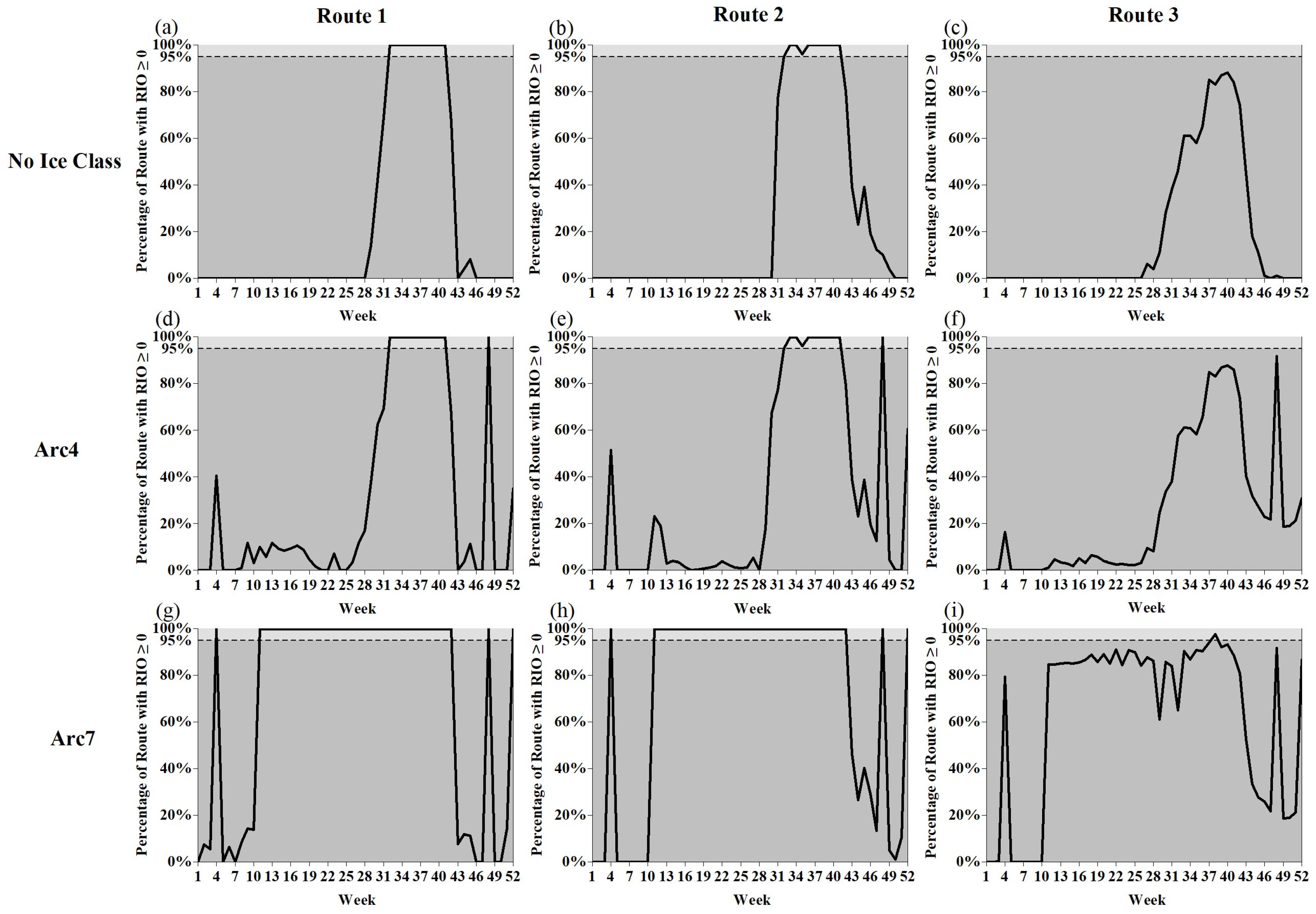
4.2.2. Navigation Windows for LNG Carriers Under Normal Ice Conditions

Figure 6a,d,g indicate that No Ice Class vessels and Arc4 vessels have navigable windows during summer and autumn on Route 1, while Arc7 vessels can navigate normally in spring, summer, and autumn, but their navigation is limited in winter. Figure 6b,e,h indicate that No Ice Class vessels and Arc4 vessels have navigable windows in spring and summer on Route 2, while Arc7 vessels have navigable windows in spring, summer, and autumn, but their navigation is limited in winter. Figure 6c,f,i illustrate that No Ice Class vessels and Arc4 vessels on Route 3 have navigable windows in autumn, although they offer only a single week of seaworthiness. In contrast, Arc7 vessels have navigable windows in spring, summer, and autumn, but their navigation is limited in winter.
Figure 6a–c illustrate that No Ice Class vessels have navigable windows in summer and autumn for Route 1, Route 2, and Route 3. While Route 1 and Route 2 share the same navigable window, the window for Route 3 is smaller, providing only a single week of seaworthiness. Figure 6d–f demonstrate that Arc4 vessels have navigable windows in summer and autumn for Route 1, Route 2, and Route 3. While Routes 1 and 2 have identical navigable windows, Route 3 offers a smaller window and is only seaworthy for a single week. Figure 6g–i indicate that Arc7 vessels have navigable windows in spring, summer, and autumn for Route 1, Route 2, and Route 3.
Figure 6 illustrates that under normal ice conditions, No Ice Class and Arc4 vessels have only a brief period of seaworthiness on Route 3, whereas Arc7 vessels are seaworthy throughout spring, summer, and autumn on the same route.
Table 4 summarizes the number of weeks that various ice class vessels are navigable under normal ice conditions. For Route 1 and Route 2, which have more favourable ice conditions, the navigable periods are comparable to those of Arc4 vessels, including No Ice Class vessels, which have no ice resistance.

4.2.3. Navigation Window for LNG Carriers Under Heavy Ice Conditions

Figure 7a,d,g illustrate that No Ice Class vessels and Arc4 vessels have navigable windows in summer and autumn on Route 1, whereas Arc7 vessels have navigable windows throughout spring, summer, and autumn. Figure 7b,e,h indicate that No Ice Class vessels and Arc4 vessels have navigable windows during summer and autumn on Route 2, whereas Arc7 vessels have navigable windows in spring, summer, and autumn. Figure 7c,f,i indicate that No Ice Class vessels and Arc4 vessels are not navigable on Route 3, whereas Arc7 vessels are navigable for only a single week in autumn.
Figure 7a–c indicate that No Ice Class vessels have navigable windows in summer and autumn on Route 1 and Route 2, which share the same window, while Route 3 is not navigable. Figure 7d–f illustrate that Arc4 vessels have navigable windows in summer and autumn on Route 1 and Route 2, which share the same window, while Route 3 remains unnavigable. Figure 7g–i indicate that Arc7 vessels are navigable during spring and summer on Route 1 and Route 2, while Route 3 is navigable for only a single week in autumn.
It can be observed that No Ice Class vessels and Arc4 vessels are not navigable on Route 3 under heavy ice conditions, while Arc7 vessels can navigate for only a single week in autumn.
Table 5 summarizes the number of weeks that various Ice Class vessels are navigable under heavy ice conditions. As illustrated in Figure 7, the navigable windows for No Ice Class vessels and Arc4 vessels on Route 1 and Route 2 are largely comparable, even under heavy sea ice conditions. This suggests that the sea ice conditions on both routes are quite similar, enabling No Ice Class vessels to have the same navigable windows as Arc4 vessels.

4.3. Critical Waters for LNG Carriers on the NSR

Critical waters exhibit complex or severe ice conditions, which considerably affect the safety of vessel operations. This study focuses on three routes for LNG carriers exporting LNG and 28 navigable districts defined by the NSRA [5], identifying critical waters in the NSR. Route 1 is divided into district 1, district 2, district 3, district 5, district 6, and district 7; Route 2 is divided into district 5, district 6, and district 7; and Route 3 is divided into district 5, district 6, district 7, district 8, district 9, district 10, district 12, district 13, district 14, district 17, district 20, district 22, district 23, district 24, district 25, district 26, and district 27, which divide the NSR into 20 segments. This study classified the navigable districts within the segments into four categories based on RIO: navigable waters, risky waters, hazardous waters, and critical waters. If the MinRIO in a navigable segment is greater than or equal to 0, the waters are deemed navigable. If the proportion of RIO variance above the mean in a navigable district exceeds 50% and includes a negative value, the waters are considered risky. If the MaxRIO is less than 0 in a risky district, the waters are classified as hazardous. Regarding critical waters, if a navigable segment remains in risky or hazardous waters throughout the year, it is identified as critical waters. The study identifies critical waters that are less navigable for ships of varying ice class by examining the navigable windows under light, normal, and heavy ice conditions. Table 6, Table 7, Table 8, Table 9, Table 10 and Table 11 shows the critical waters for LNG carriers on the NSR, Table 6, Table 8 and Table 10 show the classification of water types in the navigable districts for different ice class vessels, while Table 7, Table 9 and Table 11 illustrate the locations and navigable windows of critical waters for various ice class vessels in the NSR.

4.3.1. Critical Waters for No Ice Class Vessels on the NSR

According to Table 6, the critical waters for No Ice Class vessels in the NSR include waters from the Kara Strait to the southeast of Novaya Zemlya (navigable district 1 and navigable district 2, with an east–west range of approximately 483 km and a central geographic coordinate of 72.40° N, 63.80° E); the northern part of Ob Bay (navigable district 6 and navigable district 7, with an east–west range of approximately 385.5 km and a central geographic coordinate of 74.16° N, 72.88° E); from the Yamal Peninsula to the Vilkitsky Strait (navigable district 8, navigable district 10 and navigable district 12, with an east–west range of approximately 594.5 km and a central geographic coordinate of 77.38° N, 90.49° E); the New Siberian Islands to the eastern part of Laptev Sea (navigable district 14 and navigable district 17, with an east–west range of approximately 364 km and a central geographic coordinate of 76.54° N, 132.17° E); and the eastern part of East Siberian Sea to the De Long Strait (navigable district 20, navigable district 22, navigable district 23, and navigable district 24, with an east–west range of approximately 1206.5 km and a central geographic coordinate of 73.70° N, 158.89° E). Table 7 provides details on the extent and central coordinates of the critical waters for No Ice Class vessels.
Table 7 illustrates the navigable windows for No Ice Class vessels in the critical waters of the NSR under varying sea ice conditions. Critical water A1 and critical water B1 provide the best navigable conditions, with ranges from (70.80° N, 58.79° E) to (74.00° N, 69.34° E) and from (72.50° N, 73.71° E) to (75.62° N, 74.58° E), respectively. Following these is critical water D1, which extends from (76.31° N, 124.90° E) to (76.46° N, 139.52° E). Critical water C1 and critical water E1 present the most challenging sea ice conditions, with segments ranging from (76.32° N, 77.97° E) to (77.79° N, 104.12° E) and from (76.46° N, 139.54° E) to (70.51° N, 173.80° E).

4.3.2. Critical Waters for Arc4 Vessels on the NSR

Table 8 indicates that for Arc4 vessels, the critical waters in the NSR include the Vilkitsky Strait (navigable district 8 and navigable district 12, with an east–west extent of approximately 90.5 km and central geographic coordinates of 77.58° N, 102.42° E), the New Siberian Islands to the eastern part of the Laptev Sea (navigable district 14 and navigable district 17, with an east–west extent of approximately 364 km and central geographic coordinates of 76.54° N, 132.17° E), and the eastern part of the East Siberian Sea to the De Long Strait (navigable district 20, navigable district 22, navigable district 23, and navigable districts 24, with an east–west extent of approximately 1260 km and central geographic coordinates of 73.70° N, 158.89° E). The extent and central coordinates of the critical waters for Arc4 vessels are summarized in Table 9.
Table 9 presents the navigable windows for Arc4 vessels in the critical waters of the NSR under varying sea ice conditions. Among these, critical water B2 provides superior navigable conditions, with segments ranging from (76.31° N, 124.90° E) to (76.46° N, 139.52° E). The next most significant district is critical water A2, spanning from (77.47° N, 100.5° E) to (77.79° N, 104.12° E). Critical water C2 exhibits the most challenging sea ice class conditions, with ranges from (76.46° N, 139.54° E) to (70.51° N, 173.80° E).

4.3.3. Critical Waters for Arc7 Vessels on the NSR

As shown in Table 10, the critical water for Arc7 vessels in the NSR encompasses the western part of the East Siberian Sea (navigable district 23 and navigable district 24), with an east–west range of approximately 458 km and a centre at the geographic coordinates 72.07° N, 165.65° E. The extent and central coordinates of these critical waters are detailed in Table 11.
Table 11 outlines the navigable windows for Arc7 vessels within the critical waters of the NSR under various sea ice conditions. Specifically, for these vessels, the critical waters include the western part of the East Siberian Sea, defined by a sector extending from coordinates (70.93° N, 171.19° E) to (73.40° N, 160.01° E).

4.4. Navigability of LNG Carriers

By analyzing Section 4.2 and Section 4.3, the navigable windows and critical waters for the three specified routes can be deduced, with detailed information pertaining to No Ice Class vessels, Arc4 vessels, and Arc7 vessels provided in Table 12, Table 13 and Table 14, respectively.
As illustrated in Table 12, the primary impact on No Ice Class vessels operating on Route 1 and Route 2 is due to sea ice conditions in the Kara Sea, resulting in more consistent navigable windows. During periods of light ice conditions, the navigable window is primarily concentrated between July and November, with restrictions mainly attributed to critical water A1 (spanning from the Kara Strait to the southeast of Novaya Zemlya) and critical water B1 (located in the northern part of Ob Bay). Under heavy ice conditions, summer sea ice extends to the Kara Strait and the northern part of Ob Bay (Table 6), resulting in a 63-day reduction in navigable time compared to the light ice conditions. For Route 3, navigable time is mainly restricted by critical water B1 (the northern part of the Ob Bay), critical water C1 (Yamal Peninsula to the Vilkitsky Strait), critical water D1 (New Siberian Islands to the eastern part of Laptev Sea) and critical water E1 (the Eastern part of East Siberian Sea to the De Long Strait). The navigable period is concentrated from August to November under light ice conditions. Under heavy ice conditions, sea ice covers the Kara Sea, Laptev Sea, and East Siberian Sea, rendering the NSR unnavigable. Furthermore, during the summer and autumn navigable period, No Ice Class vessels face specific operational risks along Route 3, particularly in navigable district 5 (Kara Sea West), navigable district 13 (Laptev Sea West), navigable district 25, navigable district 26, and navigable district 27 (Chukchi Sea) (Table 6).
As shown in Table 13, Arc4 vessels are capable of navigating on Route 1 and Route 2 throughout the year under conditions of light ice. However, under heavy ice conditions, Arc4 vessels still face operational hazards in navigable district 2, navigable district 3, navigable district 5, navigable district 6, navigable district 7, navigable district 8, navigable district 9, and navigable district 10 within the Kara Sea, as shown in Table 8. Notably, when sea ice accumulates in the Kara Strait, the navigable period is reduced by 294 days compared to light ice conditions. For Route 3, the navigable period is primarily limited by critical waters A2 (Vilkitsky Strait), B2 (New Siberian Islands to the eastern part of the Laptev Sea), and C2 (the eastern East Siberian Sea to the De Long Strait). Under light ice conditions, Arc4 vessels can navigate Route 3 from January to March and from August to December. However, under heavy ice conditions, the extent of ice coverage in the Kara Sea, Laptev Sea, and East Siberian Sea renders Route 3 impassable. Additionally, during the summer and autumn navigable period, Route 3 faces operational risks in navigable district 3 (Kara Sea West), navigable district 10 (Kara Sea East), navigable district 13 (Laptev Sea West), and navigable district 27 (Chukchi Sea) (Table 8).
As indicated in Table 14, Arc7 vessels are able to navigate Route 1 and Route 2 year-round under light ice conditions. However, under heavy ice conditions, navigation in spring and winter is hindered by sea ice, and Arc7 vessels still face certain operational risks in navigable district 2, navigable district 3, navigable district 5, navigable district 6, 7, navigable district 8, navigable district 9, and navigable district 10 (Kara Sea) (Table 10). At this time, the sea ice extent covers the entire Kara Sea, reducing the navigable period by 170 days compared to light ice conditions. For Route 3, the navigable period is primarily constrained by critical water A3 (East Siberian Sea West). Under light ice conditions, Arc7 vessels can achieve year-round navigation on Route 3. However, under heavy ice conditions, the ice extent covers the East Siberian Sea. Additionally, during summer and autumn navigation, Arc7 vessels face some risks when navigating in district 8 and district 10 (Kara Sea East), district 12 and district 14 (Laptev Sea West), district 17 (Laptev Sea East), district 20 (East Siberian Sea East), and district 22 (East Siberian Sea East) (Table 10).
From the above analysis, it is evident that critical water A1, critical water B1, critical water C1, critical water D1 (B2), critical water E1(C2), critical water A2, and critical water A3 cause dynamic changes in the navigable periods for LNG carriers of No Ice Class vessels, Arc4 vessels, and Arc7 vessels. For the NSR, sea ice conditions in the East Siberian Sea (critical water E1, critical water C2, and critical water A3) significantly impact route openings, primarily driven by land runoff and sea surface wind patterns. Under heavy ice conditions, land runoff in the East Siberian Sea is low, and the prevailing wind direction is mainly westerly. This situation prevents the Pacific warm current from entering the waters, which hinders the melting of sea ice and results in a significantly shorter navigable period or even complete unnavigability [33]. The second region is the Laptev Sea (critical water D1, critical water B2, and critical water A2), where changes in sea ice conditions are primarily influenced by winter temperature accumulation and wind patterns. The accumulation of abnormally low temperatures in the previous winter can lead to severe sea ice conditions in the following summer. Additionally, strong northerly winds in the region compress the sea ice from the central Arctic Ocean toward the southern of Laptev Sea, making navigation difficult [34]. The sea ice conditions in the Kara Sea (critical water A1, critical water B1, and critical water C1) are primarily influenced by winter cumulative temperature and wind patterns. The accumulation of abnormally low temperatures in the previous winter can lead to severe ice conditions in the following summer. Additionally, strong westerly winds during summer attenuate the warm air from the Barents Sea when sea ice cover is low, slowing the melting of sea ice in the Kara Sea [18,35]. Regarding sea ice distribution in the NSR, Lu [36] noted that even in 2020, when ice conditions were favourable, sea ice remained primarily concentrated on the eastern and western sides of the East Siberian Sea and in the western of the Vilkitsky Strait. In contrast, the Kara Sea and the areas near the recommended routes in the Laptev Sea were essentially ice-free. However, in 2021, a year of severe ice conditions, even during the period of the lightest sea ice from mid-August to early October, 70% to 90% of the waters in the western and central parts of the East Siberian Sea, the Vilkitsky Strait, and the southern part of the Kara Sea were covered with sea ice [37]. In terms of vessel navigability, Min et al. [38,39] identified the Laptev Sea and the East Siberian Sea as critical waters along the NSR for OWvessels and PC6 vessels. Lei et al. [8] noted that in years with poor ice conditions, the Kara Sea, Laptev Sea, and East Siberian Sea are relatively inaccessible, particularly around the Vilkitsky Strait at 90° E to 110° E. An et al. [14] identified three critical waters for IA vessels that align with those identified for Arc4 vessels in this study. Icebreakers primarily operate during the winter months when ice conditions are more severe [40]. In the critical waters of the East Siberian Sea, icebreaker support will also be essential during the summer [2,41]. Chen et al [13] indicated that from 2041 to 2050, while Arc7 vessels will be able to transit the NSR in winter and spring, certain regions along the East Siberian Sea coast will remain inaccessible in April and May.
Regarding navigable windows, the NSRA has established the following regulations for vessels of different ice classes: No Ice Class vessels may follow icebreakers from July to November 15 each year; Arc4 vessels to Arc9 vessels can navigate from July to November each year and into June of the following year, depending on sea ice conditions as classified by Russia [5,42]. This aligns more closely with the navigable time for vessels of different ice classes under the light type of sea ice conditions identified in this study. In this study, light sea ice conditions, normal ice conditions, and heavy ice conditions are defined as MinRIO, MeanRIO, and MaxRIO over a 10-year period, respectively. In contrast, Russia classifies sea ice density as follows: 0 to 35% as light f ice conditions, 35% to 65% as medium ice conditions, and greater than 65% as heavy ice conditions [43]. It is evident that the definition of heavy ice conditions in this study aligns with an abnormally heavy ice year during the study period. However, the navigable window under the definition of normal ice conditions is shorter than that specified by the NSRA for vessels of different ice classes. In contrast to this study, the Russian definition of ice conditions may underestimate the risks associated with ship operations, potentially leading to safety hazards. Lu [37] points out that although Russian ice forecasts indicate that the entire the NSR will remain under light ice conditions until late November, the first icebreaker fleet began providing icebreaking services on October 22. Meanwhile, several ships experienced ice jams in regions such as the south-central Kara Sea and the East Siberian Sea. Chen et al. [44] state that between 2045 and 2055, OW vessels will be able to navigate in the NSR from August to October. Zhao et al. [45] indicate that under the SSP 5-8.5 scenario, PC7 vessels will be able to navigate the NSR during all seasons except for spring starting in 2070. Additionally, Chen et al. [13] point out that under a global warming scenario of 1.5 °C, PC4 vessels can navigate the NSR throughout the year. This suggests that the NSR offers better navigability under light ice conditions. In years of abnormally heavy ice, however, navigation may be disrupted. Studies by Min and An indicate that independent No Ice Class vessels and IA vessels are unable to navigate the NSR under heavy ice conditions [14,39].

5. Conclusions

From both temporal and spatial dimensions, this study systematically examines the navigability of LNG carriers in the NSR, using the POLARIS methodology to research its operational risks from 2014 to 2023. The aim is to determine the navigable windows for different ice class LNG carriers under varying sea ice conditions and to identify the critical waters for these vessels along the NSR. Three routes were selected for exporting LNG from Sabetta port to the east and west: Route 1 and Route 2 from Sabetta through the Kara Sea and the Barents Sea to Europe, and Route 3 from Sabetta through the eastern Kara Sea, the Laptev Sea, the Eastern Siberian Sea, and the Chukchi Sea, and across the Bering Strait to Asia.
The results of the study show the following: (1) Under normal and heavy ice conditions, the navigability of Route 1 and Route 2 is more significantly influenced by the Kara Sea, which is a critical water. The navigable windows for No Ice Class vessels and Arc4 vessels along the NSR are concentrated from August to October, while for Arc7 vessels, the navigable windows along the NSR are concentrated from March to November. Additionally, under normal ice conditions, the navigable windows for Route 3 are more influenced by the Laptev Sea and the East Siberian Sea. For Route 3 under normal ice conditions, navigability is more affected by the Laptev Sea and the East Siberian Sea. The navigable windows for No Ice Class vessels and Arc4 vessels are limited to September and October, whereas for Arc7 vessels, they span from March to October. Under heavy ice conditions, Route 3 is non-navigable for No Ice Class vessels, Arc4 vessels, and Arc7 vessels. (2) Under light ice conditions, Arc4 vessels can navigate year-round on the LNG export routes to Europe (Route 1 and Route 2), while Arc7 vessels can navigate year-round across the entire NSR (Route 1, Route 2, and Route 3). It should be noted that No Ice Class vessels, with the assistance of an icebreaker escort, can navigate year-round in the NSR, except in the Eastern Siberian Sea. Overall, the navigable conditions for Route 1 and Route 2, which export LNG to the west, are significantly better than those of Route 3 to the east. Under light ice conditions, Route 1 and Route 2 allow year-round transportation for low-ice-class (No Ice Class) vessels and medium-ice-class (Arc4) vessels, provided they are escorted by icebreakers. In contrast, under heavy ice conditions, Route 3 requires icebreaker assistance to ensure navigability for No Ice Class vessels, Arc4 vessels, and Arc7 vessels.
Overall, this study provides a comprehensive evaluation of the operational risks faced by LNG carriers under various sea ice conditions. Compared to the navigable windows established by Russia and other scholars for the NSR, this study employs a more conservative methodology. By delineating navigable windows and identifying critical waters for different ice class vessels across diverse ice conditions, this research offers valuable insights and references for stakeholders in their decision-making processes. Furthermore, the study highlights the potential underestimation of operational risks faced by vessels travelling along the NSR by the NSRA. A comparative analysis of these risks is crucial for refining the POLARIS methodology and improving vessel safety within these waters. Moreover, critical waters significantly impact navigable windows, underscoring the need for a more detailed exploration of the mechanisms and spatiotemporal patterns of sea ice formation in these regions. This exploration will assist shipping companies and governmental bodies in implementing effective safety measures.

Author Contributions

L.M.: writing—review and editing, conceptualization, methodology, funding acquisition, data curation, supervision. S.Q.: writing—original draft, writing—review and editing, methodology, visualization, software, formal analysis, project administration, funding acquisition. H.D.: writing—review and editing, validation, data curation, project administration, supervision. J.F.: writing—review and editing, validation, data curation. J.X.: writing—review and editing, funding acquisition, resources, supervision. L.C.: Writing—review and editing, resources, supervision. S.X.: Writing—review and editing, investigation, visualization. X.L.: writing—review and editing, investigation, validation. C.C.: writing—review and editing, investigation, data curation. Y.H.: writing—review and editing, investigation, visualization. M.C.: writing—review and editing, investigation, resources. All authors have read and agreed to the published version of the manuscript.

Funding

This research was supported by the Program for Scientific Research Start-up Funds of Guangdong Ocean University: Research on the Navigability of Arctic Shipping Routes Based on Sea Ice Condition Analysis, grant number 060302132106, the Guangdong Provincial Key Laboratory of Intelligent Equipment for South China Sea Marine Ranching, grant number 080508132401, the Guangdong Basic and Applied Basic Research Foundation, grant numbers 2022A1515011603, 2023A1515011212, the Special Projects in Key Fields of Ordinary Universities in Guangdong Province, grant number 2022ZDZX3005, the Natural Science Foundation of Shenzhen, grant number JCYJ20220530162200001, Postgraduate Education Innovation Project of Guangdong Ocean University, grant number 202421,the Fund of Guangdong Provincial Key Laboratory of Intelligent Equipment for South China Sea Marine Ranching, grant number 2023B1212030003.

Institutional Review Board Statement

Not applicable.

Informed Consent Statement

Not applicable.

Data Availability Statement

The sea ice condition data can be downloaded from https://usicecenter.gov/Products/ArcticData (accessed on 12 December 2023).

Conflicts of Interest

The authors declare no conflicts of interest.

References

  1. Rigot-Müller, P.; Cheaitou, A.; Etienne, L.; Faury, O.; Fedi, L. The role of polarseaworthiness in shipping planning for infrastructure projects in the Arctic: The case of Yamal LNG plant. Transp. Res. Part A Policy Pract. 2022, 155, 330–353. [Google Scholar] [CrossRef]
  2. Nazarov, D. Analysis of Shipping Traffic in the NSR Waters in 2020. Available online: https://arctic-lio.com/analysys-of-shipping-traffic-in-the-nsr-waters-in-2020/ (accessed on 10 May 2024).
  3. Friskilä, Ø. NSR Shipping Activities in 2022. Available online: https://chnl.no/research/reports-reports/nsr-shipping-activities-in-2022/ (accessed on 10 May 2024).
  4. Nazarov, D. NSR Shipping Traffic—Export of LNG from Sabetta in 2021. Available online: https://arctic-lio.com/nsr-shipping-traffic-export-of-lng-from-sabetta-in-2021/ (accessed on 10 May 2024).
  5. Rules of Navigation on the Water Area of the Northern Sea Route, Approved by the Decree N 1487 of the Government of the Russian Federation, 18 September 2020. Available online: http://rosatomflot.ru/img/all/0_rules_of_navigation_nsr_2020.pdf (accessed on 20 June 2024).
  6. Samotuga, V.N.; Smirnov, A.Y.; Khmara, D.S. Rethinking Year-Round Navigation via the Northern Sea Route. In Energy of the Russian Arctic: Ideals and Realities; Springer: Singapore, 2022; pp. 349–361. [Google Scholar] [CrossRef]
  7. Liu, X.; Ma, L.; Wang, J.; Wang, Y.; Wang, L.-N. Navigable windows of the Northwest Passage. Polar Sci. 2017, 13, 91–99. [Google Scholar] [CrossRef]
  8. Lei, R.B.; Xie, H.J.; Wang, J.; Leppäranta, M.; Jónsdóttir, I.; Zhang, Z. Changes in sea ice conditions along the Arctic Northeast Passage from 1979 to 2012. Cold Reg. Sci. Technol. 2015, 119, 132–144. [Google Scholar] [CrossRef]
  9. Canada, T.C.; User Assistance Package for the Implementation of Canada’s Arctic Ice Regime Shipping System (AIRSS) Standards. Transport Canada. 1998. Available online: https://publications.gc.ca/collections/collection_2017/tc/T29-133-1998-eng.pdf (accessed on 20 June 2024).
  10. Maritime, S.C. Guidance on Methodologies for Assessing Operational Capabilities and Limitations in Ice. In Tech. Rep. MSC. 1/Circ. 1519; International Maritime Organization: London, UK, 2016; Available online: https://www.nautinst.org/uploads/assets/uploaded/2f01665c-04f7-4488-802552e5b5db62d9.pdf (accessed on 20 June 2024).
  11. Browne, T.; Tran, T.T.; Veitch, B.; Smith, D.; Khan, F.; Taylor, R. A Method for Evaluating Operational Implications of Regulatory Constraints on Arctic Shipping. Mar. Policy 2022, 135, 104839. [Google Scholar] [CrossRef]
  12. Bond, J.; Oldford, D.; Moakler, E. Viability of the Northwest Passage as North America’s Resource Export Highway. In Proceedings of the Offshore Technology Conference, Houston, TX, USA, 1–4 May 2023; p. D031S111R004. [Google Scholar] [CrossRef]
  13. Chen, J.L.; Kang, S.C.; Wu, A.D.; Hu, D.-D. Impacts of 1.5 °C global warming on hydrological conditions of navigation along the Northern Sea Route and Northwest Passage. Adv. Clim. Chang. Res. 2023, 14, 904–912. [Google Scholar] [CrossRef]
  14. An, L.; Ma, L.; Wang, H.; Zhang, H.-Y.; Li, Z.-H. Research on navigation risk of the Arctic Northeast Passage based on POLARIS. J. Navig. 2022, 75, 455–475. [Google Scholar] [CrossRef]
  15. Chen, S.Y.; Kern, S.; Li, X.Q.; Hui, F.-M.; Ye, Y.-F.; Cheng, X. Navigability of the Northern Sea Route for Arc7 ice-class vessels during winter and spring sea-ice conditions. Adv. Clim. Chang. Res. 2022, 13, 676–687. [Google Scholar] [CrossRef]
  16. Li, Z.; Hu, S.; Gao, G.; Yao, C.; Fu, S.; Xi, Y. Decision-Making on Process Risk of Arctic Route for LNG Carrier via Dynamic Bayesian Network Modeling. J. Loss Prev. Process Ind. 2021, 71, 104473. [Google Scholar] [CrossRef]
  17. Fu, S.; Goerlandt, F.; Xi, Y. Arctic Shipping Risk Management: A Bibliometric Analysis and a Systematic Review of Risk Influencing Factors of Navigational Accidents. Saf. Sci. 2021, 139, 105254. [Google Scholar] [CrossRef]
  18. Yu, M.; Lu, P.; Li, Z.; Li, Z.; Wang, Q.; Cao, X.; Chen, X. Sea ice conditions and navigability through the Northeast Passage in the past 40 years based on remote-sensing data. Int. J. Digit. Earth 2020, 14, 555–574. [Google Scholar] [CrossRef]
  19. Wu, A.; Che, T.; Xu, Q.; Wang, J.; Chen, J.; Zhu, X. Assessing the economic viability of the Arctic Northeast Passage from 2021 to 2065. Int. J. Digit. Earth 2024, 17, 2323182. [Google Scholar] [CrossRef]
  20. Kumar, A.; Yadav, J.; Mohan, R. Spatio-Temporal Change and Variability of Barents-Kara Sea Ice, in the Arctic: Ocean and Atmospheric Implications. Sci. Total Environ. 2021, 753, 142046. [Google Scholar] [CrossRef] [PubMed]
  21. Arctic Data Support Files. Available online: https://usicecenter.gov/Products/ArcticData (accessed on 30 October 2024).
  22. World Meteorological Organization (WMO). Intergovernmental Oceanographic Commission of the United Nations Educational, Scientific and Cultural Organization (IOC-UNESCO) SIGRID-3:A Vector Archive Format for Sea Ice Charts. Available online: https://library.wmo.int/records/item/37171-sigrid-3-a-vector-archive-format-for-sea-ice-charts (accessed on 30 October 2024).
  23. Canada, T. Polar Classes. Available online: https://tc.canada.ca/en/marine-transportation/arctic-shipping/polar-classes (accessed on 30 October 2024).
  24. Table of Contents. “Finnish-Swedish Ice Class Rules”. Available online: https://www.sjofartsverket.se/globalassets/isbrytning/pdf-regelverk/finnish-swedish_iceclass_rules.pdf#page=3.12 (accessed on 30 October 2024).
  25. Cao, Y.F.; Yu, M.; Hui, F.M.; Zhang, J.; Cheng, X. Review of navigability changes in trans-Arctic routes. Chin. Sci. Bull. 2021, 66, 21–33. [Google Scholar] [CrossRef]
  26. Bond, J.; Hindley, R.; Kendrick, A.; Kämäräinen, J.; Kuulila, L. Evaluating risk and determining operational limitations for ships in ice. In Proceedings of the OTC Arctic Technology Conference 2018, Houston, TX, USA, 5–7 November 2018. [Google Scholar] [CrossRef]
  27. Sibul, G.; Jin, J.G. Evaluating the feasibility of combined use of the Northern Sea Route and the Suez Canal Route considering ice parameters. Transp. Res. Part A Policy Pract. 2021, 147, 350–369. [Google Scholar] [CrossRef]
  28. Øyen, K.A. Assessment of Operational Risks in Polar Areas–Risk Assessment using the Polar Operational Limits Assessment Risk Indexing System (POLARIS) and Predictive Simulations. In NTNU: 2020. Available online: https://hdl.handle.net/11250/2780090 (accessed on 20 September 2024).
  29. Fedi, L.; Etienne, L.; Faury, O.; Rigot-Muller, P.; Stephenson, S.; Cheaitou, A. Arctic Navigation: Stakes, Benefits and Limits of the Polaris System. J. Ocean Technol. 2018, 13, 54–67. Available online: https://hal.science/hal-02110281/document (accessed on 20 September 2024).
  30. Schach, M.; Madlener, R. Impacts of an Ice-Free Northeast Passage on LNG Markets and Geopolitics. Energy Policy 2018, 122, 438–448. [Google Scholar] [CrossRef]
  31. Pang, X.; Zhang, C.; Ji, Q.; Chen, Y.; Zhen, Z.; Zhu, Y.; Yan, Z. Analysis of Sea Ice Conditions and Navigability in the Arctic Northeast Passage during the Summer from 2002–2021. Geo-Spat. Inf. Sci. 2023, 26, 465–479. [Google Scholar] [CrossRef]
  32. Boundaries of the Water Area of the Northern Sea Route. Available online: https://nsr.rosatom.ru/en/official-information/boundaries-of-the-water-area-of-the-northern-sea-route/ (accessed on 14 November 2024).
  33. Ma, L.; Li, Z.H.; Chen, G.; Li, Y. Research on the navigability of the Arctic Northeast Route based on sea ice conditions during the passage of M/V Yong Sheng. Chin. J. Polar Res. 2018, 30, 173–185. [Google Scholar] [CrossRef]
  34. Yao, W.J.; Zhao, J.P. Study on Multiyear Variations of Sea Ice in the Laptev Sea of the Arctic Ocean. Chin. J. Polar Res. 2013, 25, 218–225. [Google Scholar] [CrossRef]
  35. Duan, C.L.; Dong, S.; Wang, Z.F. Statistical analysis on the engineering sea ice regime in the Kara Sea in the Arctic. Trans. Oceanol. Limnol. 2020, 3, 52–60. [Google Scholar] [CrossRef]
  36. Lu, H.M. Review and outlook for the 2020 Arctic navigation. World Shipp. 2021, 44, 24–27. [Google Scholar] [CrossRef]
  37. Lu, H.M. Review and thoughts on the 2021 commercial ship navigation in the Arctic Northeast Passage. World Shipp. 2022, 45, 1–5. [Google Scholar] [CrossRef]
  38. Min, C.; Yang, Q.; Chen, D.; Yang, Y.; Zhou, X.; Shu, Q.; Liu, J. The Emerging Arctic Shipping Corridors. Geophys. Res. Lett. 2022, 49, e2022GL099157. [Google Scholar] [CrossRef]
  39. Min, C.; Zhou, X.; Luo, H.; Yang, Y.; Wang, Y.; Zhang, J.; Yang, Q. Toward Quantifying the Increasing Accessibility of the Arctic Northeast Passage in the Past Four Decades. Adv. Atmos. Sci. 2023, 40, 2378–2390. [Google Scholar] [CrossRef]
  40. Nazarov, D. NSR Shipping Traffic—Icebreaker Support in 2021. Available online: https://arctic-lio.com/nsr-shipping-traffic-icebreaker-support-in-2021/ (accessed on 1 September 2024).
  41. Balmasov, S. Start of Eastbound Voyages on the NSR in 2024. Available online: https://arctic-lio.com/start-of-eastbound-voyages-on-the-nsr-in-2024/ (accessed on 30 August 2024).
  42. Maritime Safety Administration of the People’s Republic of China. Arctic Navigation Guide (Northeast Passage); People’s Transportation Publishing House: Beijing, China, 2021. [Google Scholar]
  43. Types of Ice Conditions. Available online: https://nsr.rosatom.ru/en/navigational-and-weather-information/types-of-ice-conditions/ (accessed on 1 September 2024).
  44. Chen, J.; Kang, S.; Du, W.; Guo, J.; Xu, M.; Zhang, Y.; Zhong, X.; Zhang, W.; Chen, J. Perspectives on future sea ice and navigability in the Arctic. Cryosphere 2021, 15, 5473–5482. [Google Scholar] [CrossRef]
  45. Zhao, P.J.; Li, Y.L. Modeling the Impacts of Climate Change on the Arctic. Res. Sq. 2024, preprint. [Google Scholar] [CrossRef]
Figure 1. Study area.
Jmse 12 02166 g001
Figure 2. Attribute table for SIGRID-3-format sea ice data. Note: CT, CA, CB, and CC represent sea ice concentration, while SA, SB, and SC indicate sea ice stage of development. For the specific meanings of the codes CT, CA, CB, CC, SA, SB, and SC, please refer to Section 3.1.1.
Jmse 12 02166 g002
Figure 3. Technical roadmap.
Jmse 12 02166 g003
Figure 4. Arc4 RIO distribution for vessels ((a) January; (b) September). Note: This map depicts the 28 districts defined by the NSRA of Russia [32]. The boundaries are explicitly defined in the “Rules for Navigation in the Waters of the Northern Sea Route” [5].
Jmse 12 02166 g004
Figure 5. Percentage of vessels of different ice classes with RIO ≥ 0 on NSR under light ice conditions. Note: Each subfigure in the series illustrates the percentage of weekly RIO values greater than or equal to 0 under light ice conditions. (a,d,g) were corresponding to No Ice Class, Arc4 and Arc7 for Route 1 respectively. (b,e,h) were corresponding to No Ice Class, Arc4 and Arc7 for Route 2. (c,f,i) were corresponding to No Ice Class, Arc4 and Arc7 for Route 3.
Jmse 12 02166 g005
Figure 6. Percentage of vessels of different ice classes with RIO ≥ 0 on NSR under normal ice conditions. Note: Each subfigure in the series illustrates the percentage of weekly RIO values greater than or equal to 0 under normal ice conditions. (a,d,g) were corresponding to No Ice Class, Arc4 and Arc7 for Route 1 respectively. (b,e,h) were corresponding to No Ice Class, Arc4 and Arc7 for Route 2. (c,f,i) were corresponding to No Ice Class, Arc4 and Arc7 for Route 3.
Jmse 12 02166 g006
Figure 7. Percentage of vessels of different ice classes with RIO ≥ 0 on NSR under heavy ice conditions. Note: Each subfigure in the series illustrates the percentage of weekly RIO values greater than or equal to 0 under heavy ice conditions. (a,d,g) were corresponding to No Ice Class, Arc4 and Arc7 for Route 1 respectively. (b,e,h) were corresponding to No Ice Class, Arc4 and Arc7 for Route 2. (c,f,i) were corresponding to No Ice Class, Arc4 and Arc7 for Route 3.
Jmse 12 02166 g007
Table 2. Operation under POLARIS [29].
RIOIce Class PC1–PC7Ice Class Below PC1–PC7
RIO ≥ 0Normal operationNormal operation
−10 ≤ RIO < 0Elevated operational riskOperation subject to special consideration
RIO < −10Operation subject to
special consideration
Table 3. Navigable windows for three ice classes of vessels under light ice conditions.
Ice Class of VesselShipping RoutesNavigable Start WeekNavigable End WeekNumber of Navigable Weeks
No Ice ClassRoute 1Week 28Week 4619
Route 2Week 27Week 4519
Route 3Week 33Week 4412
Arc4Route 1Week 1Week 5252
Route 2Week 1Week 5252
Route 3Week 1Week 1212
Week 31Week 5222
Arc7Route 1Week 1Week 5252
Route 2Week 1Week 5252
Route 3Week 1Week 5252
Note: Number of navigable weeks includes the navigable start week and navigable end week.
Table 4. Navigable windows for three ice classes of vessels under normal ice conditions.
Ice Class of VesselShipping RoutesNavigable Start WeekNavigable End WeekNumber of Navigable Weeks
No Ice ClassRoute 1Week 31Week 4212
Route 2Week 31Week 4212
Route 3Week 39Week 402
Arc4Route 1Week 32Week 4211
Route 2Week 31Week 4212
Route 3Week 39Week 424
Arc7Route 1Week 11Week 4232
Route 2Week 11Week 4232
Route 3Week 12Week 4231
Note: Number of navigable weeks includes the navigable start week and navigable end week.
Table 5. Navigable windows for three ice classes of vessels under heavy ice conditions.
Ice Class of VesselShipping RoutesNavigable Start WeekNavigable End WeekNumber of Navigable Weeks
No Ice ClassRoute 1Week 32Week 4110
Route 2Week 32Week 4110
Route 3--0
Arc4Route 1Week 32Week 4110
Route 2Week 32Week 4110
Route 3--0
Arc7Route 1Week 11Week 4232
Route 2Week 11Week 4232
Route 3Week 38Week 381
Note: “-”—navigation of ship is prohibited; navigable weeks include the navigable start week and navigable end week.
Table 6. Classification of water types in navigable districts for No Ice Class vessels.
District12356789101213141720222324252627
Season
Spring********************
Summer--+-***+**---*******
Autumn--++---+-*+***---+++
Winter********************
Note: navigable water represented by “+”; risky water represented by “-”; hazardous water represented by “*”. Critical waters are highlighted with grey shading in the tables.
Table 7. Positions in the critical waters and navigable windows for No Ice Class vessels in the NSR.
Critical WatersEast–West Water Region ExtentGeographical Coordinates of the CentreNavigable Period Under Light Sea Ice ConditionsNavigable Period Under Normal Sea Ice ConditionsNavigable Period Under Heavy Sea Ice Conditions
A1: Kara Strait to the southeast of Novaya Zemlya(70.80° N, 58.79° E) to (74.00° N, 69.34° E), 483 km of water area(72.40° N, 63.8° E)Week: 27–51 (total: 25 weeks).
RIO ∈ {0, 30}.
Week: 27–45 (total: 19 weeks).
RIO ∈ [0, 30].
Week: 33–42 (total: 10 weeks).
RIO ∈ {0, 30}.
B1: The northern part of Ob Bay(72.50° N, 73.71° E) to (75.62° N, 74.58° E), 385.5 km of water area(74.16° N, 72.88° E)Week: 27–47 (total: 21 weeks).
RIO ∈ {−5, 0, 30}.
Week: 29–43 (total: 15 weeks).
RIO ∈ [8, 30].
Week: 32–41 (total:), 10 weeks.
RIO ∈ {0, 30}.
C1: Yamal Peninsula to the Vilkitsky Strait(76.32° N, 77.97° E) to (77.79° N, 104.12° E), 594.5 km of water area(77.38° N, 90.49° N)Week: 30–44 (total: 15 weeks).
RIO ∈ {30}.
Week: 35–42 (total:8 weeks).
RIO ∈ [−2,30].
Not navigable.
RIO ∈ [−80, 30].
D1: New Siberian Islands to the eastern part of Laptev Sea(76.31° N, 124.90° E) to (76.46° N, 139.52° E), 364 km of water area(76.54° N, 132.17° E)Week: 26–44 (total: 19 weeks).
RIO ∈ {−9, 30}.
Week: 33–43 (total: 11 weeks).
RIO ∈ [9, 30].
Week: 39–41 (total: 3 weeks).
RIO ∈ [−18, 30]
E1: The eastern part of East Siberian Sea to the De Long Strait(76.46° N, 139.54° E) to (70.51° N, 173.80° E), 1206.5 km of water area(73.70° N, 158.89° E)Week: 30–44 (total: 15 weeks).
RIO ∈ {−30, −24, −18, −15, 0, 30}.
Week: 36–43 (total: 8 weeks).
RIO ∈ [−9, 30].
Not navigable.
RIO ∈ [−80, 30].
Note: Critical water D1 is equal to critical water B2, and critical water E1 is equal to critical water C2.
Table 8. Classification of water types in navigable districts for Arc4 vessels.
District12356789101213141720222324252627
Season
Spring++-+-+-+---------++-
Summer++-+++-++--------++-
Autumn++++++-+--+------+++
Winter+-------------------
Note: navigable water represented by “+”; risky water represented by “-”; Critical waters are highlighted with grey shading in the tables.
Table 9. Positions in the critical waters and navigable windows for Arc4 vessels in the NSR.
Critical WatersEast–West Water Region ExtentGeographical Coordinates of the CentreNavigable Period Under Light Sea Ice ConditionsNavigable Period Under Normal Sea Ice ConditionsNavigable Period Under Heavy Sea Ice Conditions
A2: Vilkitsky Strait(77.47° N, 100.5° E) to (77.79° N, 104.12° E), 90.5 km of water area(77.58° N, 102.42° N)Week: 1–52 (total: 52 weeks).
RIO ∈ [3, 30].
Week: 30–52 (total: 23 weeks). RIO ∈ [−6, 30].Not navigable. RIO ∈ [−30, 30].
B2: New Siberian Islands to the eastern part of Laptev Sea(76.31° N, 124.90° E) to (76.46° N, 139.52° E), 364 km of water area(76.54° N, 132.17° E)Week 1–52 (total: 52 weeks).
RIO ∈ [10, 30].
Week: 2–4, 26–52 (total: 30 weeks).
RIO ∈ [−5, 30].
Week: 38–39 (total: 2 weeks).RIO ∈ [−18, 30].
C2: The eastern part of East Siberian Sea to the De Long Strait(76.46° N, 139.54° E) to (70.51° N, 173.80° E), 1260 km of water area(73.70° N, 158.89° E)Week 1–52 (total: 52 weeks). RIO ∈ [10, 30].Week: 33–52 (total: 20 weeks). RIO ∈ [−8, 30].Not navigable. RIO ∈ [−30, 30].
Note: Critical water B2 is equal to critical water D1, and critical water C2 is equal to critical water E1.
Table 10. Classification of water types in navigable districts for Arc4 vessels.
District12356789101213141720222324252627
Season
Spring++-++++++++++++--+++
Summer+++++++++++++++--+++
Autumn++++++-+--+------+++
Winter+-+-------+------+++
Note: navigable water represented by “+”; risky water represented by “-”; Critical waters are highlighted with grey shading in the tables.
Table 11. Positions in the critical waters and navigable windows for Arc7 vessels in the NSR.
Critical WatersEast–West Water Region ExtentGeographical Coordinates of the CentreNavigable Period Under Light Sea Ice ConditionsNavigable Period Under Normal Sea Ice ConditionsNavigable Period Under Heavy Sea Ice Conditions
A3: The western part of the East Siberian Sea(70.93° N, 171.19° E) to (73.40° N, 160.01° E), 458 km of water area(72.07° N, 165.65° E)Week: 1–52 (total: 52 weeks). RIO ∈ [16, 30]Week: 1–52 (total: 52 weeks). RIO ∈ [5, 30]Not navigable. RIO ∈ [−20, 30]
Table 12. Navigable windows and critical waters for vessels.
RouteSea Ice ConditionsNavigable WindowsCritical Waters
Route 1Light ice conditions8 July–17 NovemberA1, B1
Normal ice conditions1 August–20 October
Heavy ice conditions5 August–13 October
Route 2Light ice conditions1 July–10 NovemberB1
Normal ice conditions1 August–20 October
Heavy ice conditions5 August–13 October
Route 3Light ice conditions12 August–3 NovemberB1, C1, D1, E1
Normal ice conditions23 September–6 October
Heavy ice conditions---
Note: A1: Kara Strait to the southeast of Novaya Zemlya. B1: The northern part of Ob Bay. C1: Yamal Peninsula to the Vilkitsky Strait. D1: New Siberian Islands to the eastern part of Laptev Sea. E1: The eastern part of East Siberian Sea to the De Long Strait.
Table 13. Navigable windows and critical waters for Arc4 vessels.
RouteSea Ice ConditionsNavigable WindowsCritical Waters
Route 1Light ice conditions1 January–31 December--
Normal ice conditions5 August–20 October
Heavy ice conditions5 August–13 October
Route 2Light ice conditions1 January–31 December-
Normal ice conditions1 August–20 October
Heavy ice conditions5 August–13 October
Route 3Light ice conditions1 January to 24 March
1 August–31 December
A2, B2, C2
Normal ice conditions23 September–20 October
Heavy ice conditions---
Note: A2: Vilkitsky Strait. B2: New Siberian Islands to the eastern part of Laptev Sea. C2: The eastern of part East Siberian Sea to the De Long Strait.
Table 14. Navigable windows and critical waters for Arc7 vessels.
RouteSea Ice ConditionsNavigable WindowsCritical Waters
Route 1Light ice conditions1 January–31 December-
Normal ice conditions11 March–20 October
Heavy ice conditions11 March–20 October
Route 2Light ice conditions1 January–31 December-
Normal ice conditions11 March–20 October
Heavy ice conditions11 March–20 October
Route 3Light ice conditions1 January–31 DecemberA3
Normal ice conditions18 March–20 October
Heavy ice conditions16 September–22 September
Note: A3: The western part of the East Siberian Sea.
Disclaimer/Publisher’s Note: The statements, opinions and data contained in all publications are solely those of the individual author(s) and contributor(s) and not of MDPI and/or the editor(s). MDPI and/or the editor(s) disclaim responsibility for any injury to people or property resulting from any ideas, methods, instructions or products referred to in the content.

