
Hurricane Kay (September 2022) Impacts Rocky Shores in the Loreto Area of Baja California Sur, Mexico


Abstract
:1. Introduction
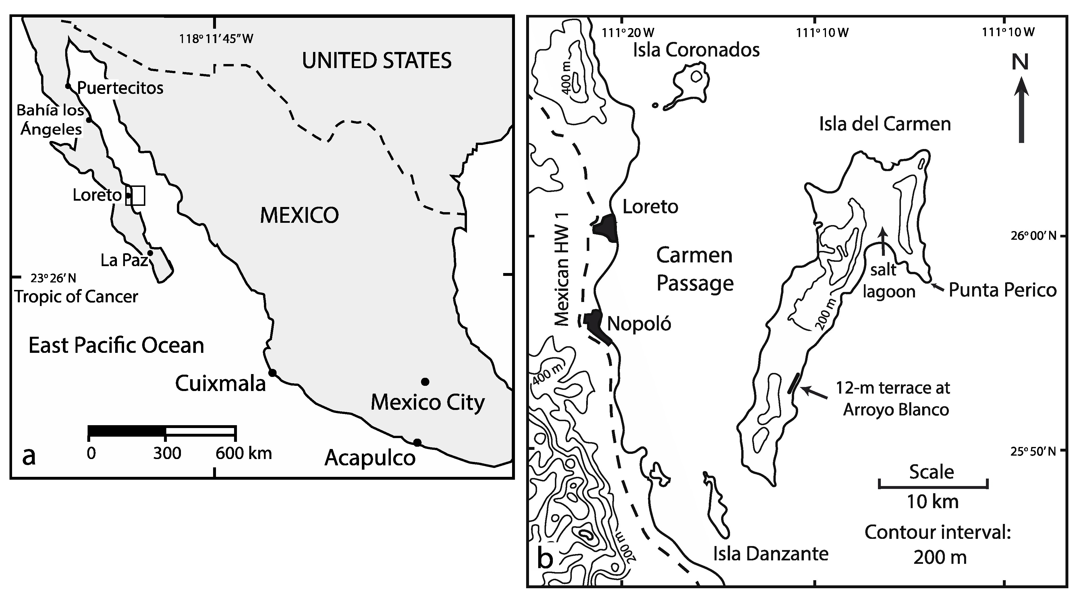
2. Geographical and Geological Setting
3. Materials and Method
3.1. Onshore Data Collection
3.2. Subtidal Observations
4. Results
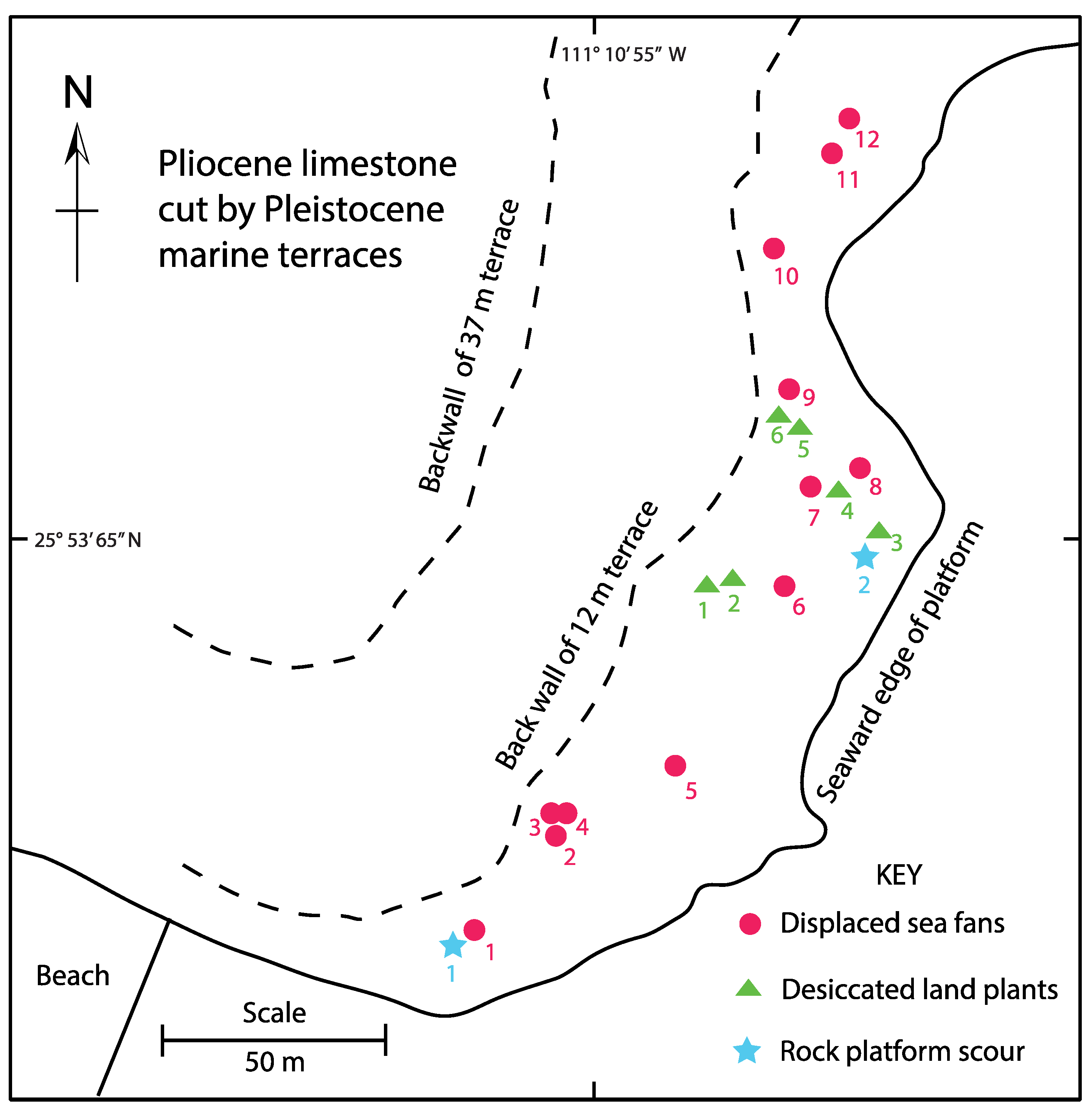
4.1. Base Map
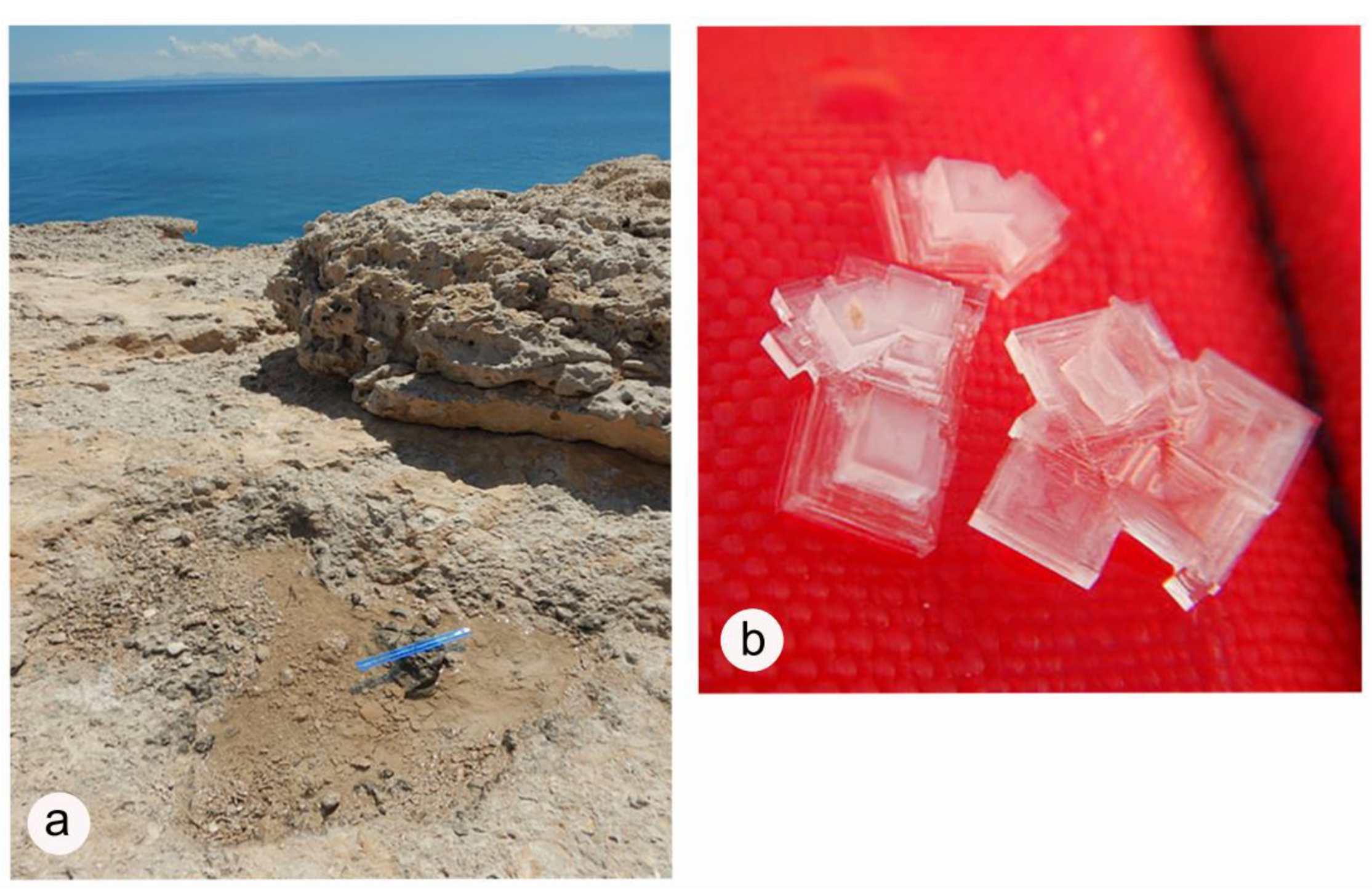
4.2. Check for Disruption of Limestone Slabs
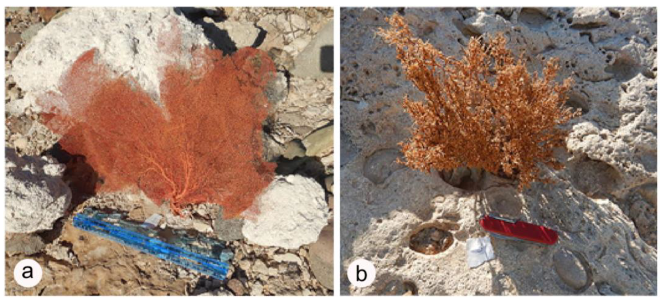
4.3. Evidence from Displaced Sea Fans
4.4. Evidence from Desiccated Land Plants
4.5. Evidence from Standing Pools of Seawater
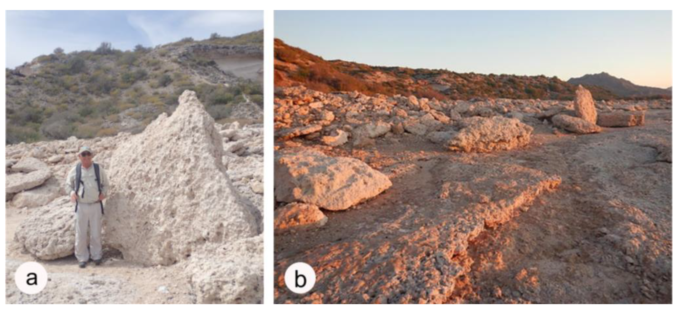
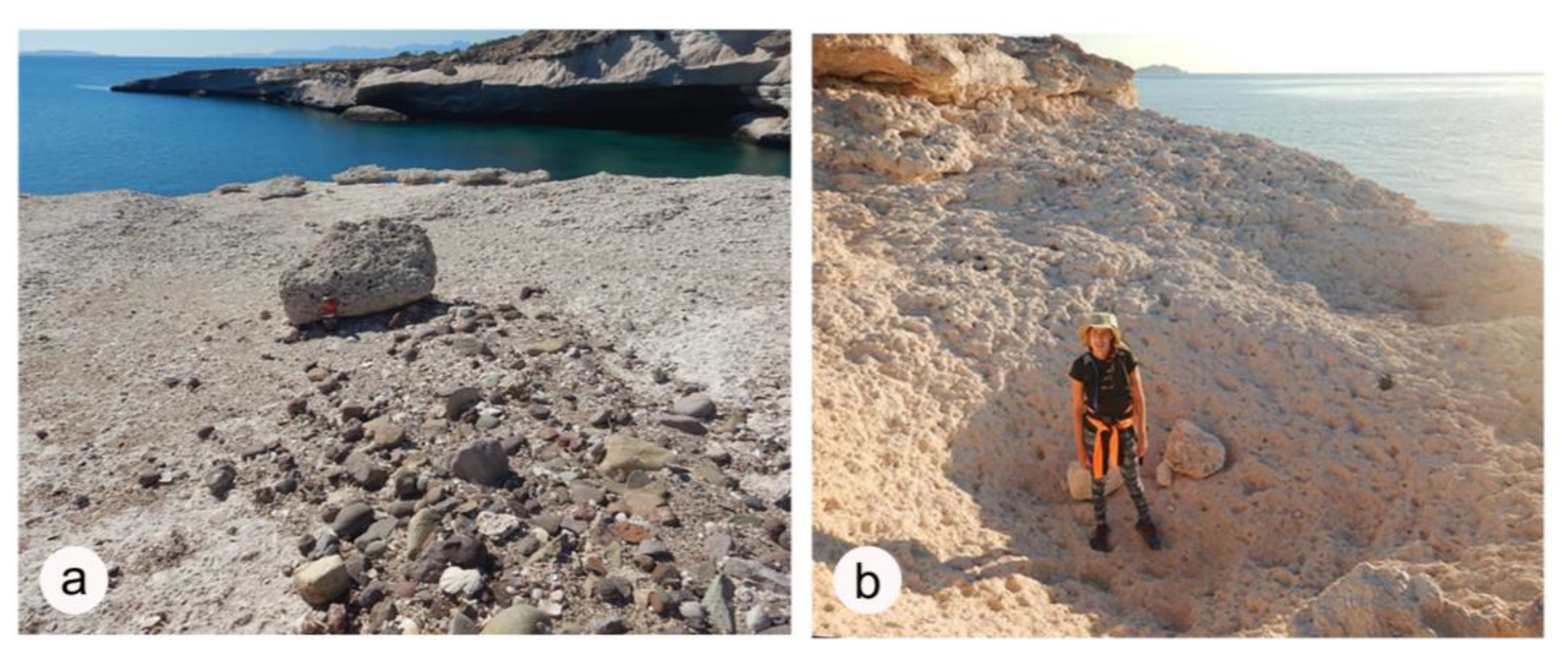
4.6. Evidence of Short-Term and Long-Term Erosion on the Limestone Terrace
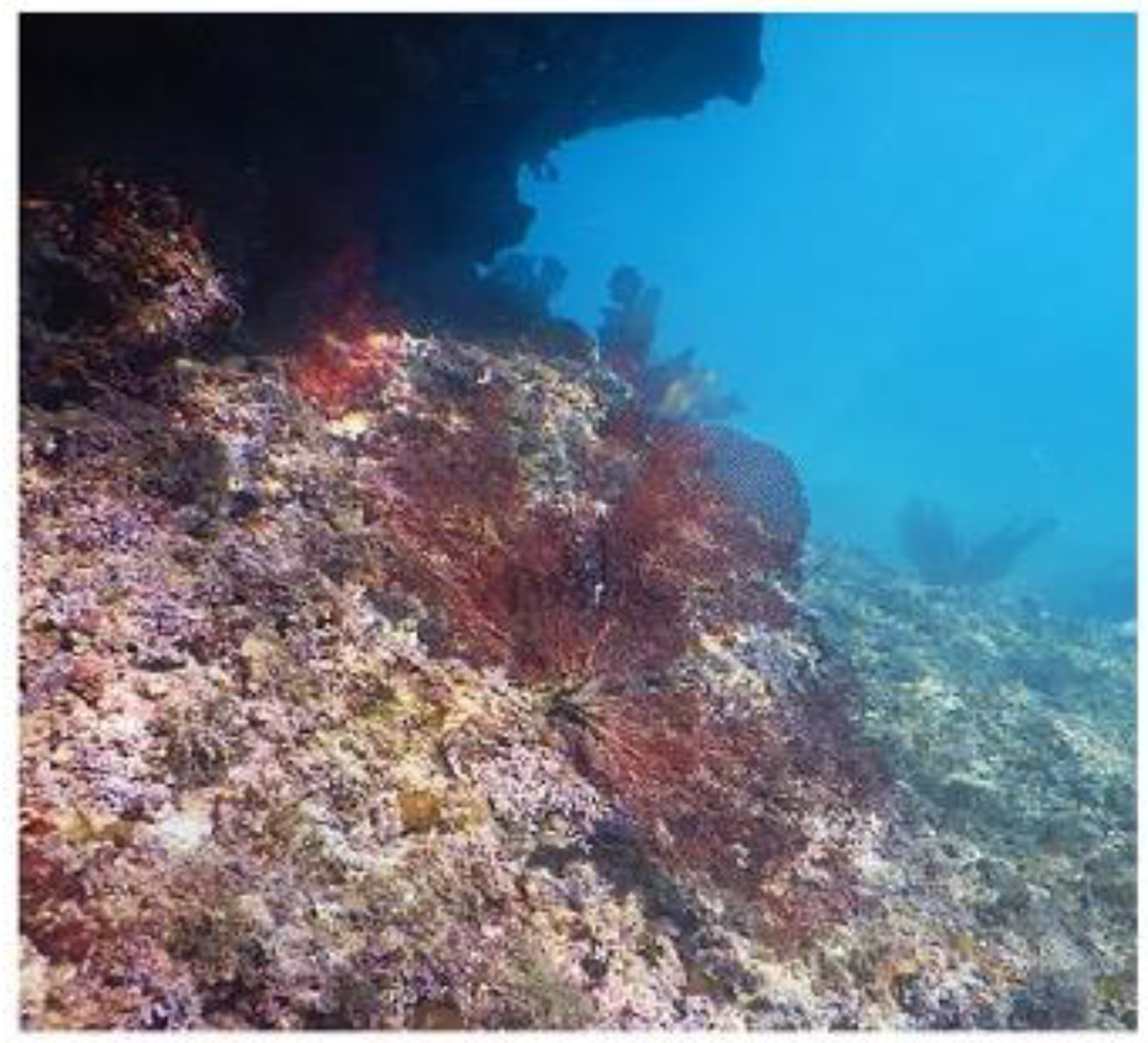
4.7. Investigation of the Sea-Fan Habitat off the Limestone Terrace
5. Discussion
6. Conclusions
Author Contributions
Funding
Institutional Review Board Statement
Informed Consent Statement
Data Availability Statement
Acknowledgments
Conflicts of Interest
References
- Avila, L. The 2015 eastern North Pacific hurricane season: A very active year. Weatherwise 2016, 69, 36–42. [Google Scholar] [CrossRef]
- Muriá-Vila, D.; Jaimes, M.Á.; Pozos-Estrada, A.; López, A.; Reinoso, E.; Chávez, M.M.; Peña, F.; Sánchez-Sesma, J.; Lóppez, O. Effects of Hurricane Odile on the infrastructure of Baja California Sur, Mexico. Nat. Hazards 2018, 9, 963–981. [Google Scholar] [CrossRef]
- Tierney, P.W.; Johnson, M.E. Stabilization role of crustose coralline alga during Late Pleistocene reef development on Isla Cerralvo, Baja California Sur (Mexico). J. Coast. Res. 2012, 59, 503–519. [Google Scholar]
- Callahan, G.; Johnson, M.E.; Guardado-France, R.; Ledesma-Vázquez, J. Upper Pleistocene and Holocene storm deposits eroded from the granodiorite coast on Isla San Diego (Baja California Sur, Mexico). J. Mar. Sci. Eng. 2021, 9, 555. [Google Scholar] [CrossRef]
- Johnson, M.E.; Johnson, E.M.; Guardado-France, R.; Ledesma-Vázquez, J. Holocene hurricane deposits eroded as coastal barriers from andesite sea cliffs at Puerto Escondido (Baja California Sur, Mexico). J. Mar. Sci. Eng. 2020, 8, 75. [Google Scholar] [CrossRef]
- Johnson, M.E.; Ledesma-Vázquez, J.; Guardado-Grance, R. Coastal geomorphology of a Holocene hurricane deposit on a Pleistocene marine terrace from Isla Carmen (Baja California Sur, Mexico). J. Mar. Sci. Eng. 2018, 6, 108. [Google Scholar] [CrossRef]
- Johnson, M.E.; Guardado-France, R.; Johnson, E.M.; Ledesma-Vázquez, J. Geomorphology of a Holocene hurricane deposit eroded from rhyolite sea cliffs on Ensenada Almeja (Baja California Sur, Mexico). J. Mar. Sci. Eng. 2019, 7, 193. [Google Scholar] [CrossRef]
- Guardado-France, R.; Johnson, M.E.; Ledesma-Vázquez, J.; Santa Rosa-del Rio, M.A.; Herrera-Gutiérrez, A.R. Multiphase storm deposits eroded from andesite sea cliffs on Isla San Luis Gonzaga (Northern Gulf of California, Mexico). J. Mar. Sci. Eng. 2020, 8, 525. [Google Scholar] [CrossRef]
- Available online: https://en.wikipedia.org/wiki/Hurricane_Kay_2022 (accessed on 29 January 2022).
- Holden, W.N.; Marshall, S.J. Climate change and typhoons in the Philippines: Extreme weather events in the Anthropocene. In Integrating Disaster Science and Management; Elsevier: Amsterdam, The Netherlands, 2018; pp. 407–421. [Google Scholar]
- Yin, J.; Yin, Z.; Xu, S. Composite risk assessment of typhoon-induced disaster for China′s coastal area. Nat. Hazards 2013, 69, 1423–1434. [Google Scholar] [CrossRef]
- Ledesma-Vázquez, J.; Johnson, M.E.; Gonzalez-Yajimovich, O.; Santamaría-del-Angel, E. Gulf of California geography, geological origins, oceanography and sedimentation patterns. In Atlas of Coastal Ecosystems in the Western Gulf of California; Johnson, M.E., Ledesma-Vázquez, J., Eds.; University of Arizona Press: Tucson, AZ, USA, 2009; pp. 1–10. ISBN 978-0-8165-2530. [Google Scholar]
- Merrifield, M.A.; Winant, C.D. Shelf-circulation in the Gulf of California: A description of the variability. J. Geophys. Res. 1989, 94, 133–160. [Google Scholar] [CrossRef]
- Bowen, T. On Desert Shores: Archaeology & History of the Western Midriff Islands in the Gulf of California; University of Utah Press: Salt Lake City, UT, USA, 2022; 313p, ISBN 9781647690380. [Google Scholar]
- Backus, D.H.; Johnson, M.E.; Ledesma-Vázquez, J. Peninsular and island rocky shores in the Gulf of California. In Atlas of Coastal Ecosystems in the Western Gulf of California; Johnson, M.E., Ledesma-Vázquez, J., Eds.; University of Arizona Press: Tucson, AZ, USA, 2009; pp. 10–11. ISBN 978-0-8165-2530-0. [Google Scholar]
- Carreño, A.L.; Helenes, J. Geology and ages of the islands. In A New Island Biogeography of the Sea of Cortés; Case, T.J., Cody, M.L., Ezurra, E., Eds.; Oxford University Press: Oxford, UK, 2002; ISBN 0195133463. [Google Scholar]
- Eros, M.E.; Johnson, M.E.; Backus, D.H. Rocky shores and development of the Pliocene-Pleistocene Arroyo Blanco Basin on Isla Carmen in the Gulf of California, Mexico. Can. J. Earth Sci. 2006, 43, 1149–1164. [Google Scholar] [CrossRef]
- Rebman, J.P.; Roberts, N.C. (Eds.) Baja California Plant Field Guide. San Diego Natural History Museum, 3rd ed.; Sunbelt Publications: San Diego, CA, USA, 2012; 451p, ISBN 978-0-916251-18-5. [Google Scholar]
- Report on the Gulf Star Violet (Stenotis mucronate) posted to iNaturalist by botanist Jon R. Rebman. Available online: https://www.inaturalist.org/observations/18557864 (accessed on 29 January 2023).
- Alexander, H.S. Pothole erosion. J. Geol. 1932, 40, 289–384. [Google Scholar] [CrossRef]
- Ji, S.; Li, L.; Zeng, W. The relationship between diameter and depth of potholes eroded by running water. J. Rock Mech. Geotech. Eng. 2018, 10, 818–831. [Google Scholar] [CrossRef]
- Ji, S.; Zeng, W.; Li, L.; Ma, Q.; Feng, J. Geometrical characterization of stream potholes in sandstone from the Sunzi River (Chongquing, China) and implications for the development of bedrock channels. J. Asian Earth Sci. 2019, 173, 374–385. [Google Scholar] [CrossRef]
- Swinnerton, A.C. Observations on some details of wave erosion: Wave furrows and shore potholes. J. Geol. 1927, 35, 171–179. [Google Scholar] [CrossRef]
- Abbott, A.T.; Pottratz, S.W. Marine pothole erosion, Oahu, Hawaii. Pac. Sci. 1969, 23, 276–290. [Google Scholar]
- Johnson, M.E. Geological oceanography of the Pliocene Warm Period: A review with predictions on the future of global warming. J. Mar. Sci. Eng. 2021, 9, 1210. [Google Scholar] [CrossRef]
- National Weather Service. Available online: https://www.weather.gov/mfl/saffirsimpson (accessed on 29 January 2023).
- Ball, M.M.; Shinn, E.A.; Stockman, K.W. The geologic effects of Hurricane Donna in South Florida. J. Geol. 1967, 75, 583–597. [Google Scholar] [CrossRef]
- Johnson, M.E. Baja California’s Coastal Landscapes Revealed, Excursions in Geologic Tie and Climate Change; University of Arizona Press: Tucson, AZ, USA, 2021; ISBN 13: 978-0-8165-4252-9. [Google Scholar]


| Specimen Number | Distance to Edge of the Terrace (m) | Elevation Above Mean Sea Level (m) |
|---|---|---|
| 1 | 13 | 7.5 |
| 2 | 35 | 9 |
| 3 | 38 | 8 |
| 4 | 39 | 9.5 |
| 5 | 37 | 5 |
| 6 | 24 | 6.5 |
| 7 | 15 | 7 |
| 8 | 14 | 5 |
| 9 | 63 | 9 |
| 10 | 15 | 7 |
| 11 | 27 | 6 |
| 12 | 20 | 7 |
| Mean | 28.3 | 7.2 |
| Specimen Number | Distance to Edge of the Terrace (m) | Elevation Above Mean Sea Level (m) |
|---|---|---|
| 1 | 13 | 7.5 |
| 2 | 35 | 9 |
| 3 | 38 | 8 |
| 4 | 39 | 9.5 |
| 5 | 37 | 5 |
| 6 | 24 | 6.5 |
| Mean | 31 | 7.5 |
Disclaimer/Publisher’s Note: The statements, opinions and data contained in all publications are solely those of the individual author(s) and contributor(s) and not of MDPI and/or the editor(s). MDPI and/or the editor(s) disclaim responsibility for any injury to people or property resulting from any ideas, methods, instructions or products referred to in the content. |
© 2023 by the authors. Licensee MDPI, Basel, Switzerland. This article is an open access article distributed under the terms and conditions of the Creative Commons Attribution (CC BY) license (https://creativecommons.org/licenses/by/4.0/).
Share and Cite
Johnson, M.E.; Callahan, G. Hurricane Kay (September 2022) Impacts Rocky Shores in the Loreto Area of Baja California Sur, Mexico. J. Mar. Sci. Eng. 2023, 11, 323. https://doi.org/10.3390/jmse11020323
Johnson ME, Callahan G. Hurricane Kay (September 2022) Impacts Rocky Shores in the Loreto Area of Baja California Sur, Mexico. Journal of Marine Science and Engineering. 2023; 11(2):323. https://doi.org/10.3390/jmse11020323
Chicago/Turabian StyleJohnson, Markes E., and Ginni Callahan. 2023. "Hurricane Kay (September 2022) Impacts Rocky Shores in the Loreto Area of Baja California Sur, Mexico" Journal of Marine Science and Engineering 11, no. 2: 323. https://doi.org/10.3390/jmse11020323
APA StyleJohnson, M. E., & Callahan, G. (2023). Hurricane Kay (September 2022) Impacts Rocky Shores in the Loreto Area of Baja California Sur, Mexico. Journal of Marine Science and Engineering, 11(2), 323. https://doi.org/10.3390/jmse11020323