The SAVEMEDCOASTS-2 webGIS: The Online Platform for Relative Sea Level Rise and Storm Surge Scenarios up to 2100 for the Mediterranean Coasts
Abstract
1. Introduction
2. Materials and Methods
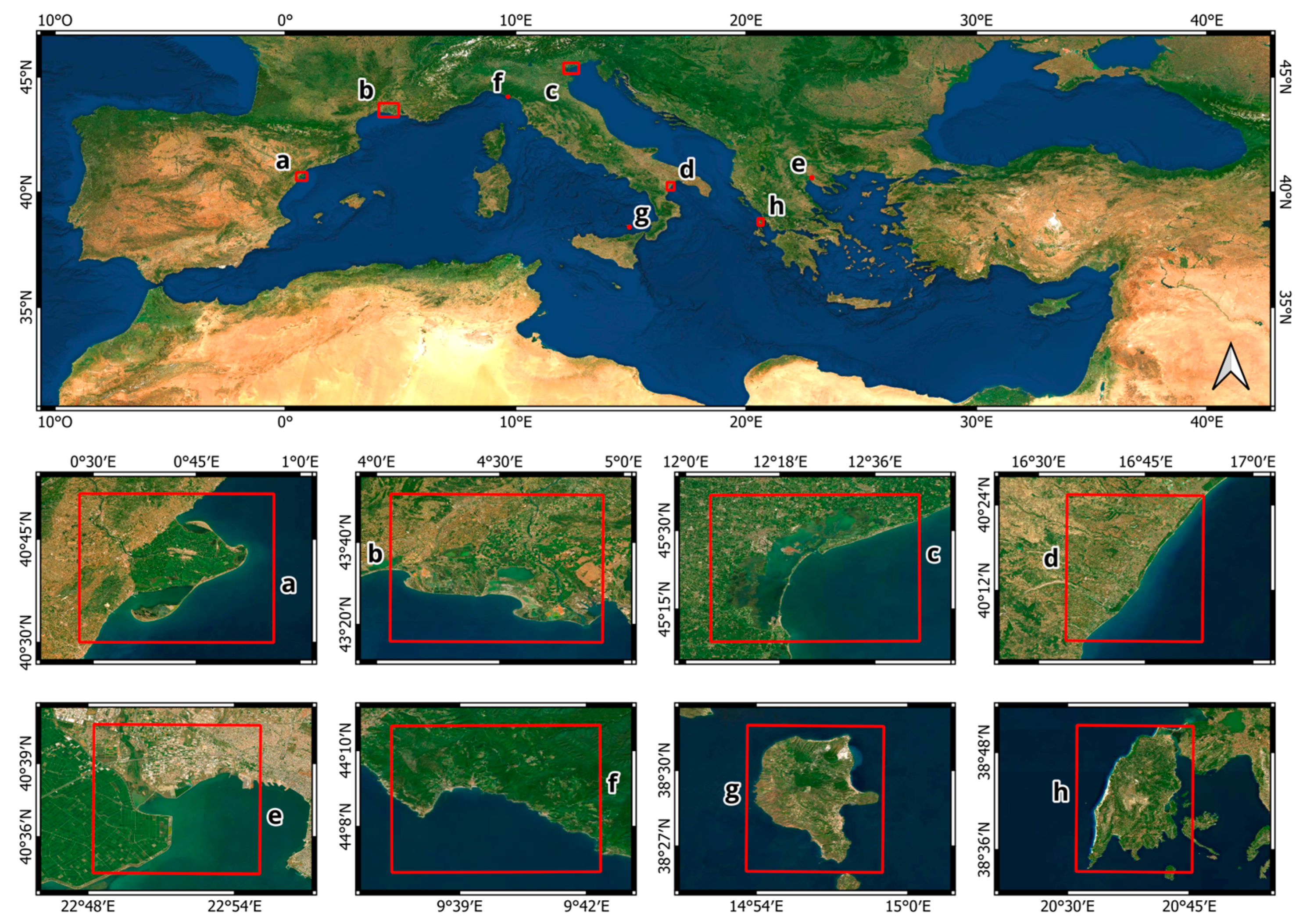
2.1. Study Areas
2.1.1. The Ebro Delta (Spain)
2.1.2. The Rhone Delta (France)
2.1.3. The Venice Lagoon (Italy)
2.1.4. The Metaponto Plain (Italy)
2.1.5. The Chalastra Plain (Greece)
2.1.6. Cinque Terre (Italy)
2.1.7. Lipari Island (Italy)
2.1.8. Lefkada Island (Greece)
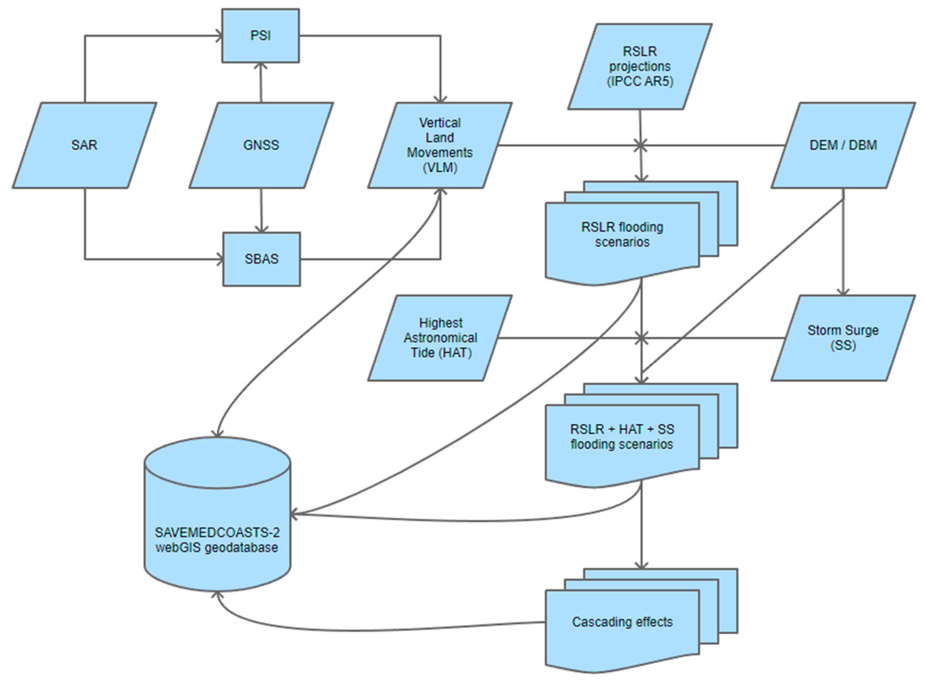
2.2. Method
- Assessment of the present-day and projected RSLR up to 2100 along the Mediterranean coasts according to the IPCC AR5 projections for the “mitigation” (RCP2.6) and the “business as usual” (RCP8.5) extreme scenarios. Projections are locally updated for the current rates of vertical land movements. The latter were estimated through a combined geodetic analysis of InSAR and GNSS data.
- Mapping the spatial extent of potential flooding areas derived from the combination of RSLR projections (RCP2.6 and RCP8.5), the highest astronomical tides (HAT), and the storm surge condition (ordinary or extreme) for all the considered epochs in 2021, 2030, 2050, and 2100.
- Preliminary assessment of cascading effects on relevant targets (e.g., land, environment, and human assets) to effectively address policymakers and coastal planners in drafting climate change adaptation plans and measures against SLR. By overlapping the potentially flooded areas with human settlements and local infrastructures (buildings, transportation networks, drainage channels, valuable crops, etc.), along with environmental ecosystems (land use/land cover, protected areas, etc.), the measures to be taken can be evaluated in terms of percentage indicators of damage or integrity on specific anthropic or environmental components.
2.2.1. Digital Terrain Models
2.2.2. Vertical Land Movements
2.2.3. Relative Sea Level Rise Scenarios
2.2.4. Wave Climate
2.2.5. Astronomical Tides
2.2.6. Storm Surges
2.2.7. Potential Coastal Flooding Scenarios
- Assessment of the wave climate and the probability distribution for the extreme condition evaluation referred to the ordinary (RT = 1 yr) and extreme SS (RT = 100 yrs);
- Definition of the design storm wave by studying the propagation of the wave motion from the open sea towards the shore;
- Definition of transects from offshore to the hinterland (possibly perpendicular to the coast) to consider in storm surge modeling;
- Evaluation of the mean VLM rate derived from the geodetic analysis across a 200 m wide buffer of each transect, as well as calculation of updated RSLR values based on this mean VLM rate under different IPCC scenarios;
- Setup of a 1-D model of storm surge for each transect and combination of SS condition (RT = 1 yr or 100 yrs), RSLR scenario (RCP2.6 or RCP8.5), plus the highest astronomical tide for 2021, 2030, 2050, and 2100;
- Analysis of the model’s output in terms of Hs (significative offshore wave height), fp (peak frequency), z0 (sea level as a combination of RSLR, subsidence, and HAT), Rmax (maximum storm run-up), and overtop per each transect and for each combination of the above-mentioned parameters;
- Mapping the potential Flooding Areas (FAs) grouped by each combination of RSLR scenario and storm surge condition (ordinary or extreme) for all the considered epochs (2021, 2030, 2050, and 2100). The analysis complies with the “bathtub” approach and the Maximum Water/Flood Elevation (MWE) defined according to the following criteria: (a) Maximum sea level observed among all the transects, whenever overtopping does not occur; (b) Maximum overtopping observed among all the transects, otherwise.
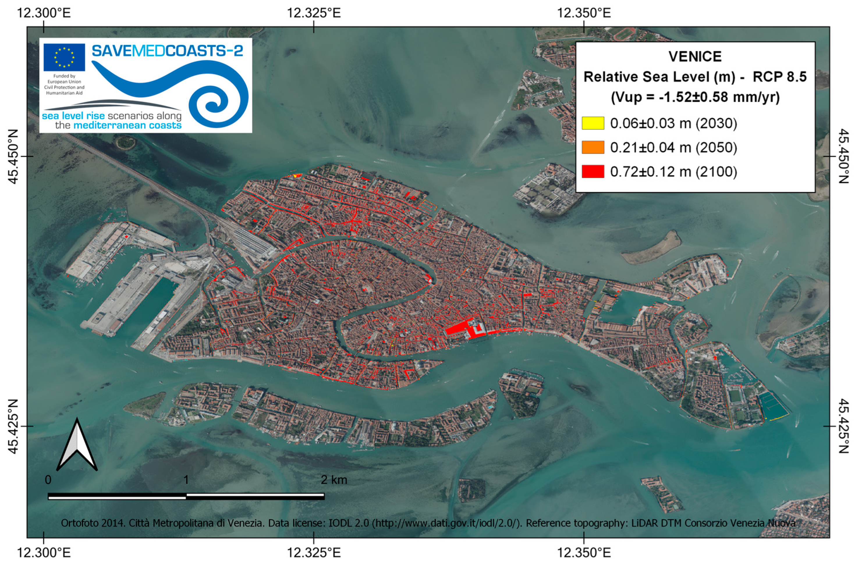
- the maps of potential land inundation scenarios for each study area, based on the RSLR projections estimated for 2030, 2050, and 2100;
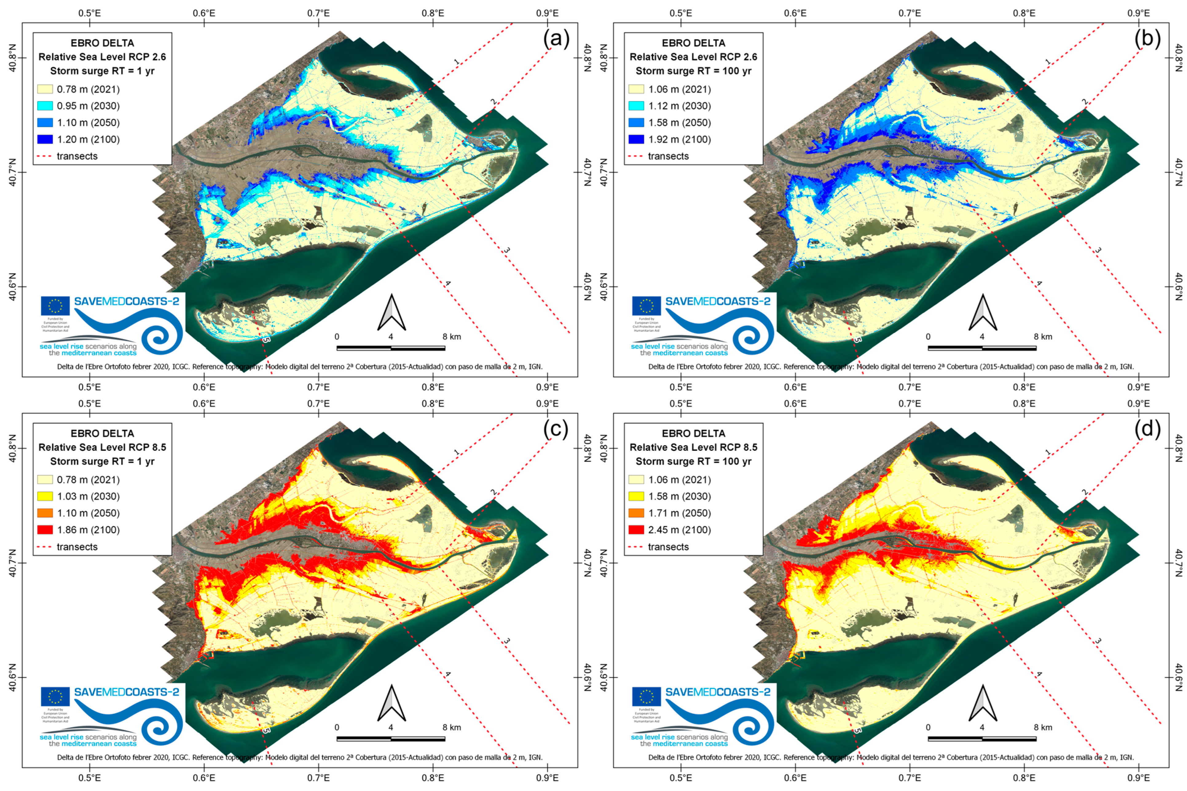
- the maps of potential flooding areas (see, for instance, Figure 4) grouped by each combination of RSLR scenario and storm surge condition for all the considered epochs (2021, 2030, 2050, and 2100).
2.2.8. Preliminary Cascading Effects due to Flooding Scenarios
2.3. The webGIS Platform
3. Results
3.1. App 1: Storm Surge Scenarios
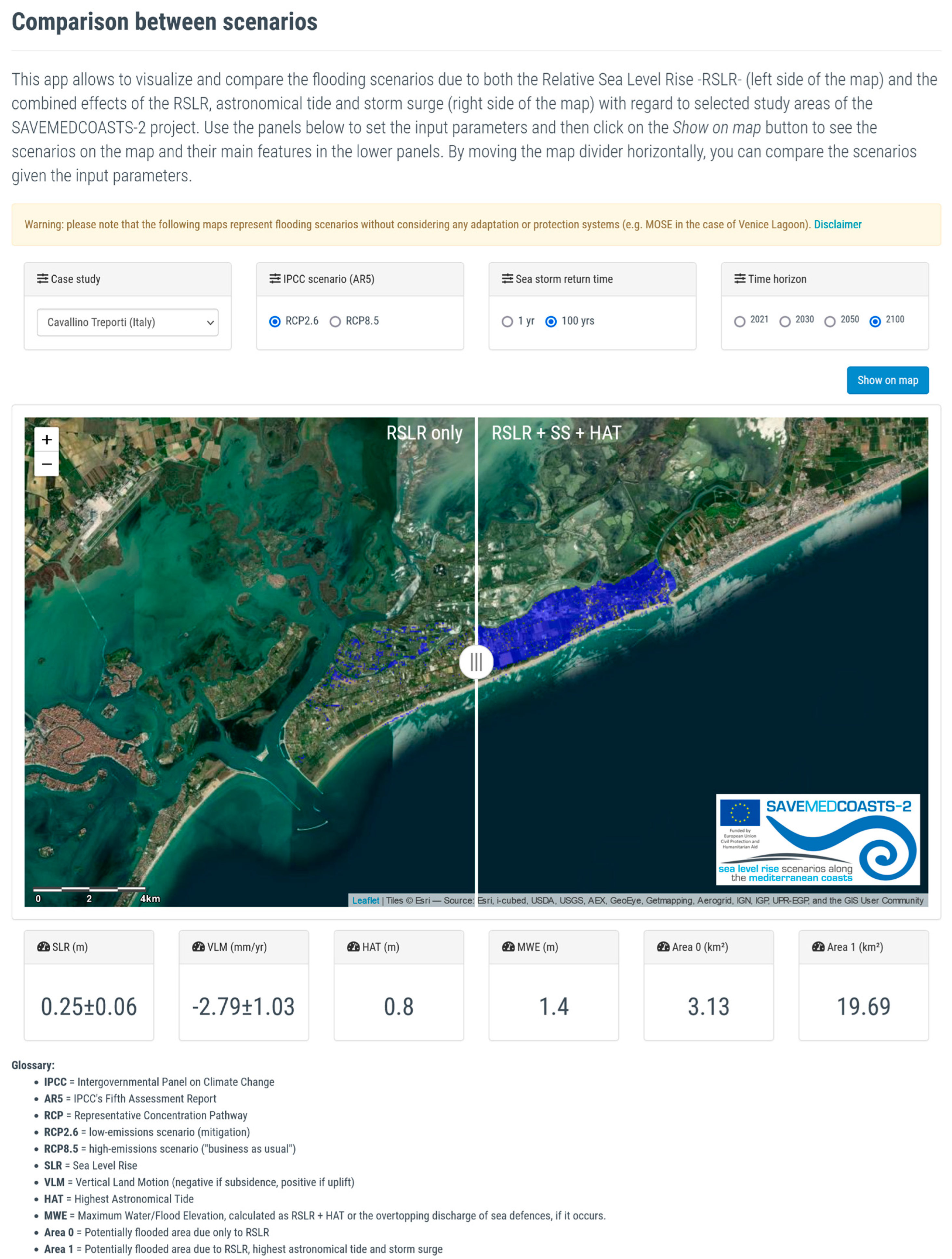
3.2. App 2: Comparison between Scenarios
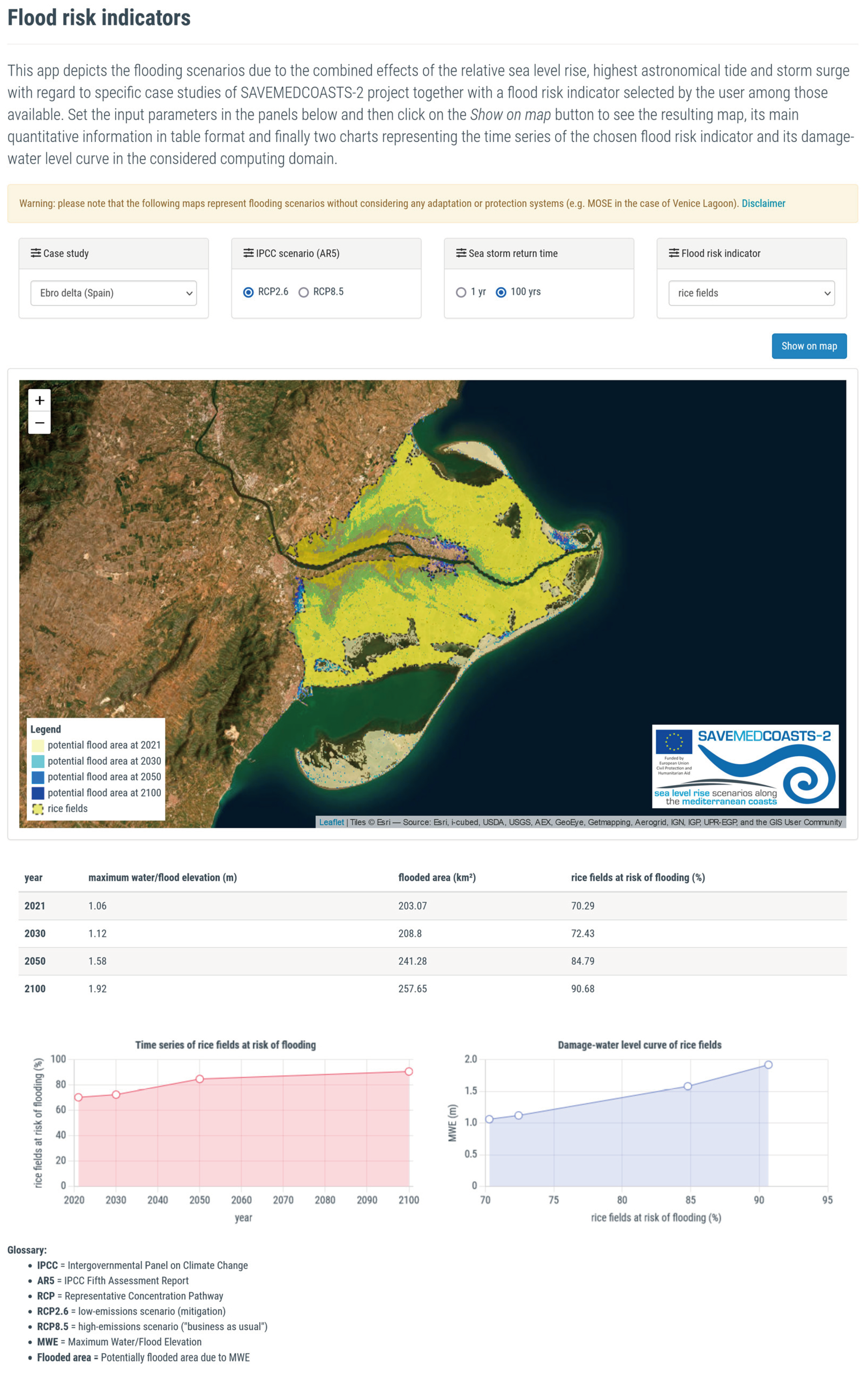
3.3. App 3: Flood Risk Indicators
4. Discussion
4.1. The Ebro Delta (Spain)
4.2. The Rhone Delta (France)
4.3. Venice Lido and Cavallino Treporti (Italy)
4.4. Metaponto (Italy)
4.5. The Chalastra Plain (Greece)
5. Conclusions
Author Contributions
Funding
Institutional Review Board Statement
Informed Consent Statement
Data Availability Statement
Acknowledgments
Conflicts of Interest
References
- IPCC. Climate Change 2021: The Physical Science Basis. Contribution of Working Group I to the Sixth Assessment Report of the Intergovernmental Panel on Climate Change; Masson-Delmotte, V., Zhai, P., Pirani, A., Connors, S.L., Péan, C., Berger, S., Caud, N., Chen, Y., Goldfarb, L., Gomis, M.I., et al., Eds.; Cambridge University Press: Cambridge, UK; New York, NY, USA, 2021. [Google Scholar]
- Oppenheimer, M.; Glavovic, B.C.; Hinkel, J.; van de Wal, R.; Magnan, A.K.; Abd-EIgawad, A.; Cai, R.; Cifuentes-Jara, M.; DeConto, R.M.; Ghosh, T.; et al. Sea Level Rise and Implications for Low-Lying Islands, Coasts and Communities. In IPCC Special Report on the Ocean and Cryosphere in a Changing Climate; Pörtner, H.-O., Roberts, D.C., Masson-Delmotte, V., Zhai, P., Tignor, M., Poloczanska, E., Mintenbeck, K., Alegría, A., Nicolai, M., Okem, A., et al., Eds.; Cambridge University Press: Cambridge, UK; New York, NY, USA, 2019; pp. 321–445. [Google Scholar] [CrossRef]
- Cid, A.; Menéndez, M.; Castanedo, S.; Abascal, A.J.; Méndez, F.J.; Medina, R. Long-Term Changes in the Frequency, Intensity and Duration of Extreme Storm Surge Events in Southern Europe. Clim. Dyn. 2016, 46, 1503–1516. [Google Scholar] [CrossRef]
- Church, J.; Clark, P.; Cazenave, A.; Gregory, J.; Jevrejeva, S.; Levermann, A.; Merrifield, M.; Milne, G.; Nerem, R.; Nunn, P.; et al. “Chapter 13: Sea Level Change” in Climate Change 2013: The Physical Science Basis: Contribution of Working Group I to the Fifth Assessment Report of the Intergovernmental Panel on Climate Change; Intergovernmental Panel on Climate Change: Geneva, Switzerland, 2013. [Google Scholar]
- Vitousek, S.; Barnard, P.L.; Fletcher, C.H.; Frazer, N.; Erikson, L.; Storlazzi, C.D. Doubling of Coastal Flooding Frequency within Decades Due to Sea-Level Rise. Sci. Rep. 2017, 7, 1399. [Google Scholar] [CrossRef] [PubMed]
- Diodato, N.; Bellocchi, G. Storminess and Environmental Changes in the Mediterranean Central Area. Earth Interact. 2010, 14, 1–16. [Google Scholar] [CrossRef]
- Sainsbury, N.C.; Genner, M.J.; Saville, G.R.; Pinnegar, J.K.; O’Neill, C.K.; Simpson, S.D.; Turner, R.A. Changing Storminess and Global Capture Fisheries. Nat. Clim. Chang. 2018, 8, 655–659. [Google Scholar] [CrossRef]
- Pirazzoli, P.A.; Regnauld, H.; Lemasson, L. Changes in Storminess and Surges in Western France during the Last Century. Mar. Geol. 2004, 210, 307–323. [Google Scholar] [CrossRef]
- Wood, M.; Haigh, I.D.; Le, Q.Q.; Nguyen, H.N.; Tran, H.B.; Darby, S.E.; Marsh, R.; Skliris, N.; Hirschi, J.J.-M.; Nicholls, R.J.; et al. Climate-Induced Storminess Forces Major Increases in Future Storm Surge Hazard in the South China Sea Region. Nat. Hazards Earth Syst. Sci. 2023, 23, 2475–2504. [Google Scholar] [CrossRef]
- Calafat, F.M.; Wahl, T.; Tadesse, M.G.; Sparrow, S.N. Trends in Europe Storm Surge Extremes Match the Rate of Sea-Level Rise. Nature 2022, 603, 841–845. [Google Scholar] [CrossRef]
- Islam, M.R.; Duc, L.; Sawada, Y.; Satoh, M. Does Mean Sea Level Trend Mask Historical Storm Surge Trend: Evidence from Tropical Cyclones Affecting Japan since 1980. Environ. Res. Lett. 2023, 18, 085004. [Google Scholar] [CrossRef]
- Cavicchia, L.; von Storch, H.; Gualdi, S. Mediterranean Tropical-Like Cyclones in Present and Future Climate. J. Clim. 2014, 27, 7493–7501. [Google Scholar] [CrossRef]
- Toomey, T.; Amores, A.; Marcos, M.; Orfila, A. Coastal Sea Levels and Wind-Waves in the Mediterranean Sea since 1950 from a High-Resolution Ocean Reanalysis. Front. Mar. Sci. 2022, 9, 991504. [Google Scholar] [CrossRef]
- Marcos, M.; Tsimplis, M.N.; Shaw, A.G.P. Sea Level Extremes in Southern Europe. J. Geophys. Res. 2009, 114, C01007. [Google Scholar] [CrossRef]
- Miglietta, M.M. Mediterranean Tropical-Like Cyclones (Medicanes). Atmosphere 2019, 10, 206. [Google Scholar] [CrossRef]
- Diakakis, M.; Mavroulis, S.; Filis, C.; Lozios, S.; Vassilakis, E.; Naoum, G.; Soukis, K.; Konsolaki, A.; Kotsi, E.; Theodorakatou, D.; et al. Impacts of Medicanes on Geomorphology and Infrastructure in the Eastern Mediterranean, the Case of Medicane Ianos and the Ionian Islands in Western Greece. Water 2023, 15, 1026. [Google Scholar] [CrossRef]
- Androulidakis, Y.S.; Kombiadou, K.D.; Makris, C.V.; Baltikas, V.N.; Krestenitis, Y.N. Storm Surges in the Mediterranean Sea: Variability and Trends under Future Climatic Conditions. Dyn. Atmos. Ocean. 2015, 71, 56–82. [Google Scholar] [CrossRef]
- Androulidakis, Y.; Makris, C.; Mallios, Z.; Pytharoulis, I.; Baltikas, V.; Krestenitis, Y. Storm Surges and Coastal Inundation during Extreme Events in the Mediterranean Sea: The IANOS Medicane. Nat. Hazards 2023, 117, 939–978. [Google Scholar] [CrossRef]
- Conte, D.; Lionello, P. Storm Surge Distribution Along the Mediterranean Coast: Characteristics and Evolution. Procedia Soc. Behav. Sci. 2014, 120, 110–115. [Google Scholar] [CrossRef]
- Widlansky, M.J.; Long, X.; Schloesser, F. Increase in Sea Level Variability with Ocean Warming Associated with the Nonlinear Thermal Expansion of Seawater. Commun. Earth Environ. 2020, 1, 9. [Google Scholar] [CrossRef]
- MedECC. Climate and Environmental Change in the Mediterranean Basin—Current Situation and Risks for the Future. In First Mediterranean Assessment Report; Cramer, W., Guiot, J., Marini, K., Eds.; Union for the Mediterranean, Plan Bleu and UNEP/MAP: Marseille, France, 2020; ISBN 978-2-9577416-0-1. [Google Scholar] [CrossRef]
- Nicholls, R.J.; Lincke, D.; Hinkel, J.; Brown, S.; Vafeidis, A.T.; Meyssignac, B.; Hanson, S.E.; Merkens, J.-L.; Fang, J. A Global Analysis of Subsidence, Relative Sea-Level Change and Coastal Flood Exposure. Nat. Clim. Change 2021, 11, 338–342. [Google Scholar] [CrossRef]
- Anzidei, M.; Scicchitano, G.; Scardino, G.; Bignami, C.; Tolomei, C.; Vecchio, A.; Serpelloni, E.; De Santis, V.; Monaco, C.; Milella, M.; et al. Relative Sea-Level Rise Scenario for 2100 along the Coast of South Eastern Sicily (Italy) by InSAR Data, Satellite Images and High-Resolution Topography. Remote Sens. 2021, 13, 1108. [Google Scholar] [CrossRef]
- Scardino, G.; Anzidei, M.; Petio, P.; Serpelloni, E.; De Santis, V.; Rizzo, A.; Liso, S.I.; Zingaro, M.; Capolongo, D.; Vecchio, A.; et al. The Impact of Future Sea-Level Rise on Low-Lying Subsiding Coasts: A Case Study of Tavoliere Delle Puglie (Southern Italy). Remote Sens. 2022, 14, 4936. [Google Scholar] [CrossRef]
- Vecchio, A.; Anzidei, M.; Serpelloni, E.; Florindo, F. Natural Variability and Vertical Land Motion Contributions in the Mediterranean Sea-Level Records over the Last Two Centuries and Projections for 2100. Water 2019, 11, 1480. [Google Scholar] [CrossRef]
- Costantini, M.; Minati, F.; Trillo, F.; Ferretti, A.; Novali, F.; Passera, E.; Dehls, J.; Larsen, Y.; Marinkovic, P.; Eineder, M.; et al. European Ground Motion Service (EGMS). In Proceedings of the 2021 IEEE International Geoscience and Remote Sensing Symposium IGARSS, Brussels, Belgium, 11–16 July 2021; pp. 3293–3296. [Google Scholar]
- Crosetto, M.; Solari, L.; Mróz, M.; Balasis-Levinsen, J.; Casagli, N.; Frei, M.; Oyen, A.; Moldestad, D.A.; Bateson, L.; Guerrieri, L.; et al. The Evolution of Wide-Area DInSAR: From Regional and National Services to the European Ground Motion Service. Remote Sens. 2020, 12, 2043. [Google Scholar] [CrossRef]
- Loizidou, X.I.; Orthodoxou, D.L.; Loizides, M.I.; Petsa, D.; Anzidei, M. Adapting to Sea Level Rise: Participatory, Solution-Oriented Policy Tools in Vulnerable Mediterranean Areas. Environ. Syst. Decis. 2023, 1–19. [Google Scholar] [CrossRef] [PubMed]
- Vousdoukas, M.I.; Mentaschi, L.; Mongelli, I.; Ciscar, J.C.; Hinkel, J.; Ward, P.; Gosling, S.; Feyen, L. Adapting to Rising Coastal Flood Risk in the EU under Climate Change; Publications Office of the European Union: Luxembourg, 2020; ISBN 978-92-76-12990-5. [Google Scholar] [CrossRef]
- Rodríguez-Santalla, I.; Navarro, N. Main Threats in Mediterranean Coastal Wetlands. The Ebro Delta Case. J. Mar. Sci. Eng. 2021, 9, 1190. [Google Scholar] [CrossRef]
- Grases, A.; Gracia, V.; García-León, M.; Lin-Ye, J.; Sierra, J.P. Coastal Flooding and Erosion under a Changing Climate: Implications at a Low-Lying Coast (Ebro Delta). Water 2020, 12, 346. [Google Scholar] [CrossRef]
- López-Dóriga, U.; Jiménez, J.A. Impact of Relative Sea-Level Rise on Low-Lying Coastal Areas of Catalonia, NW Mediterranean, Spain. Water 2020, 12, 3252. [Google Scholar] [CrossRef]
- Rodriguez-Lloveras, X.; Vilà, M.; Mora, O.; Pérez, F.; Pi, R.; Marturià, J. Detection of Subsidence in the Ebro Delta Plain Using DInSAR: Analysis of the Measurements and the Factors That Control the Phenomenon. Proc. Int. Assoc. Hydrol. Sci. 2020, 382, 803–808. [Google Scholar] [CrossRef]
- Genua-Olmedo, A.; Alcaraz, C.; Caiola, N.; Ibáñez, C. Sea Level Rise Impacts on Rice Production: The Ebro Delta as an Example. Sci. Total Environ. 2016, 571, 1200–1210. [Google Scholar] [CrossRef]
- Amores, A.; Marcos, M.; Carrió, D.S.; Gómez-Pujol, L. Coastal Impacts of Storm Gloria (January 2020) over the North-Western Mediterranean. Nat. Hazards Earth Syst. Sci. 2020, 20, 1955–1968. [Google Scholar] [CrossRef]
- Arnaud-Fassetta, G.; Provansal, M. The Lower Valley and the Delta of the Rhône River: Water Landscapes of Nature and History. In Landscapes and Landforms of France; Fort, M., André, M.-F., Eds.; World Geomorphological Landscapes; Springer: Dordrecht, The Netherlands, 2014; pp. 207–218. ISBN 978-94-007-7021-8. [Google Scholar]
- de Montety, V.; Radakovitch, O.; Vallet-Coulomb, C.; Blavoux, B.; Hermitte, D.; Valles, V. Origin of Groundwater Salinity and Hydrogeochemical Processes in a Confined Coastal Aquifer: Case of the Rhône Delta (Southern France). Appl. Geochem. 2008, 23, 2337–2349. [Google Scholar] [CrossRef]
- Boutron, O.; Paugam, C.; Luna-Laurent, E.; Chauvelon, P.; Sous, D.; Rey, V.; Meulé, S.; Chérain, Y.; Cheiron, A.; Migne, E. Hydro-Saline Dynamics of a Shallow Mediterranean Coastal Lagoon: Complementary Information from Short and Long Term Monitoring. J. Mar. Sci. Eng. 2021, 9, 701. [Google Scholar] [CrossRef]
- Zanchettin, D.; Bruni, S.; Raicich, F.; Lionello, P.; Adloff, F.; Androsov, A.; Antonioli, F.; Artale, V.; Carminati, E.; Ferrarin, C.; et al. Sea-Level Rise in Venice: Historic and Future Trends (Review Article). Nat. Hazards Earth Syst. Sci. 2021, 21, 2643–2678. [Google Scholar] [CrossRef]
- Lionello, P.; Nicholls, R.J.; Umgiesser, G.; Zanchettin, D. Venice Flooding and Sea Level: Past Evolution, Present Issues, and Future Projections (Introduction to the Special Issue). Nat. Hazards Earth Syst. Sci. 2021, 21, 2633–2641. [Google Scholar] [CrossRef]
- Lionello, P.; Barriopedro, D.; Ferrarin, C.; Nicholls, R.J.; Orlić, M.; Raicich, F.; Reale, M.; Umgiesser, G.; Vousdoukas, M.; Zanchettin, D. Extreme Floods of Venice: Characteristics, Dynamics, Past and Future Evolution (Review Article). Nat. Hazards Earth Syst. Sci. 2021, 21, 2705–2731. [Google Scholar] [CrossRef]
- Alberti, T.; Anzidei, M.; Faranda, D.; Vecchio, A.; Favaro, M.; Papa, A. Dynamical Diagnostic of Extreme Events in Venice Lagoon and Their Mitigation with the MoSE. Sci. Rep. 2023, 13, 10475. [Google Scholar] [CrossRef]
- Mel, R.A.; Viero, D.P.; Carniello, L.; Defina, A.; D’Alpaos, L. The First Operations of Mo.S.E. System to Prevent the Flooding of Venice: Insights on the Hydrodynamics of a Regulated Lagoon. Estuar. Coast. Shelf Sci. 2021, 261, 107547. [Google Scholar] [CrossRef]
- Favaretto, C.; Manfè, G.; Volpato, M.; Scarpa, G.M. Effect of Mo.S.E. Closures on Wind Waves in the Venetian Lagoon: In Situ and Numerical Analyses. Water 2022, 14, 2579. [Google Scholar] [CrossRef]
- Pellicani, R.; Argentiero, I.; Fidelibus, M.D.; Zanin, G.M.; Parisi, A.; Spilotro, G. Dynamics of the Basilicata Ionian Coast: Human and Natural Drivers. Rend. Lincei. Sci. Fis. Nat. 2020, 31, 353–364. [Google Scholar] [CrossRef]
- Guariglia, A.; Buonamassa, A.; Losurdo, A.; Saladino, R.; Trivigno, M.L.; Zaccagnino, A.; Colangelo, A. A Multisource Approach for Coastline Mapping and Identification of Shoreline Changes. Ann. Geophys. 2006, 49. [Google Scholar] [CrossRef]
- Greco, M.; Martino, G. Vulnerability Assessment for Preliminary Flood Risk Mapping and Management in Coastal Areas. Nat. Hazards 2016, 82, 7–26. [Google Scholar] [CrossRef]
- Canora, F.; Muzzillo, R.; Sdao, F. Groundwater Vulnerability Assessment in the Metaponto Coastal Plain (Basilicata, Italy). Water 2022, 14, 1851. [Google Scholar] [CrossRef]
- Muzzillo, R.; Zuffianò, L.E.; Rizzo, E.; Canora, F.; Capozzoli, L.; Giampaolo, V.; De Giorgio, G.; Sdao, F.; Polemio, M. Seawater Intrusion Proneness and Geophysical Investigations in the Metaponto Coastal Plain (Basilicata, Italy). Water 2021, 13, 53. [Google Scholar] [CrossRef]
- Corbau, C.; Greco, M.; Martino, G.; Olivo, E.; Simeoni, U. Assessment of the Vulnerability of the Lucana Coastal Zones (South Italy) to Natural Hazards. J. Mar. Sci. Eng. 2022, 10, 888. [Google Scholar] [CrossRef]
- Elias, P.; Benekos, G.; Perrou, T.; Parcharidis, I. Spatio-Temporal Assessment of Land Deformation as a Factor Contributing to Relative Sea Level Rise in Coastal Urban and Natural Protected Areas Using Multi-Source Earth Observation Data. Remote Sens. 2020, 12, 2296. [Google Scholar] [CrossRef]
- Cevasco, A.; Brandolini, P.; Scospesi, C.; Rellini, I. Relationships between Geo-Hydrological Processes Induced by Heavy Rainfall and Land-Use: The Case of 25 October 2011 in the Vernazza Catchment (Cinque Terre, NW Italy). J. Maps 2013, 9, 289–298. [Google Scholar] [CrossRef]
- Anzidei, M.; Bosman, A.; Casalbore, D.; Tusa, S.; La Rocca, R. New Insights on the Subsidence of Lipari Island (Aeolian Islands, Southern Italy) from the Submerged Roman Age Pier at Marina Lunga. Quat. Int. 2016, 401, 162–173. [Google Scholar] [CrossRef]
- Romagnoli, C.; Bosman, A.; Casalbore, D.; Anzidei, M.; Doumaz, F.; Bonaventura, F.; Meli, M.; Verdirame, C. Coastal Erosion and Flooding Threaten Low-Lying Coastal Tracts at Lipari (Aeolian Islands, Italy). Remote Sens. 2022, 14, 2960. [Google Scholar] [CrossRef]
- May, S.M.; Vött, A.; Brückner, H.; Smedile, A. The Gyra Washover Fan in the Lefkada Lagoon, NW Greece—Possible Evidence of the 365 AD Crete Earthquake and Tsunami. Earth Planets Space 2012, 64, 6. [Google Scholar] [CrossRef]
- Zimbo, F.; Ingemi, D.; Guidi, G. The Tropical-like Cyclone “Ianos” in September 2020. Meteorology 2022, 1, 29–44. [Google Scholar] [CrossRef]
- Purinton, B.; Bookhagen, B. Validation of Digital Elevation Models (DEMs) and Comparison of Geomorphic Metrics on the Southern Central Andean Plateau. Earth Surf. Dyn. 2017, 5, 211–237. [Google Scholar] [CrossRef]
- Kulp, S.A.; Strauss, B.H. CoastalDEM: A Global Coastal Digital Elevation Model Improved from SRTM Using a Neural Network. Remote Sens. Environ. 2018, 206, 231–239. [Google Scholar] [CrossRef]
- Kulp, S.A.; Strauss, B.H. New Elevation Data Triple Estimates of Global Vulnerability to Sea-Level Rise and Coastal Flooding. Nat. Commun. 2019, 10, 4844. [Google Scholar] [CrossRef] [PubMed]
- Vernimmen, R.; Hooijer, A. New LiDAR-Based Elevation Model Shows Greatest Increase in Global Coastal Exposure to Flooding to Be Caused by Early-Stage Sea-Level Rise. Earths Future 2023, 11, e2022EF002880. [Google Scholar] [CrossRef]
- Anzidei, M.; Crosetto, M.; Navarro, J.; Tolomei, C.; Patias, P.; Georgiadis, C.; Vecchio, A.; Doumaz, F.; Trivigno, L.; Falciano, A.; et al. Relative Sea-Level Rise Scenarios for 2100 in the Venice Lagoon by Integrated Geodetic Data, High-Resolution Topography and Climate Projections. New Insights from the SAVEMEDCOASTS-2 Project. In Proceedings of the EGU General Assembly 2022, Vienna, Austria, 23–27 May 2022. [Google Scholar] [CrossRef]
- Crosetto, M.; Monserrat, O.; Cuevas-González, M.; Devanthéry, N.; Crippa, B. Persistent Scatterer Interferometry: A Review. ISPRS J. Photogramm. Remote Sens. 2016, 115, 78–89. [Google Scholar] [CrossRef]
- Lanari, R.; Casu, F.; Manzo, M.; Zeni, G.; Berardino, P.; Manunta, M.; Pepe, A. An Overview of the Small BAseline Subset Algorithm: A DInSAR Technique for Surface Deformation Analysis. Pure Appl. Geophys. 2007, 164, 637–661. [Google Scholar] [CrossRef]
- Lee, S.; Wolberg, G.; Shin, S.Y. Scattered Data Interpolation with Multilevel B-Splines. IEEE Trans. Vis. Comput. Graph. 1997, 3, 228–244. [Google Scholar] [CrossRef]
- Anzidei, M.; Doumaz, F.; Vecchio, A.; Serpelloni, E.; Pizzimenti, L.; Civico, R.; Greco, M.; Martino, G.; Enei, F. Sea Level Rise Scenario for 2100 A.D. in the Heritage Site of Pyrgi (Santa Severa, Italy). J. Mar. Sci. Eng. 2020, 8, 64. [Google Scholar] [CrossRef]
- Mentaschi, L.; Besio, G.; Cassola, F.; Mazzino, A. Developing and Validating a Forecast/Hindcast System for the Mediterranean Sea. J. Coast. Res. 2013, 65, 1551–1556. [Google Scholar] [CrossRef]
- Mentaschi, L.; Besio, G.; Cassola, F.; Mazzino, A. Performance Evaluation of Wavewatch III in the Mediterranean Sea. Ocean. Model. 2015, 90, 82–94. [Google Scholar] [CrossRef]
- Yunus, A.P.; Avtar, R.; Kraines, S.; Yamamuro, M.; Lindberg, F.; Grimmond, C.S.B. Uncertainties in Tidally Adjusted Estimates of Sea Level Rise Flooding (Bathtub Model) for the Greater London. Remote Sens. 2016, 8, 366. [Google Scholar] [CrossRef]
- Gallien, T.W.; Sanders, B.F.; Flick, R.E. Urban Coastal Flood Prediction: Integrating Wave Overtopping, Flood Defenses and Drainage. Coast. Eng. 2014, 91, 18–28. [Google Scholar] [CrossRef]
- Seenath, A.; Wilson, M.; Miller, K. Hydrodynamic versus GIS Modelling for Coastal Flood Vulnerability Assessment: Which Is Better for Guiding Coastal Management? Ocean Coast. Manag. 2016, 120, 99–109. [Google Scholar] [CrossRef]
- Anderson, T.R.; Fletcher, C.H.; Barbee, M.M.; Romine, B.M.; Lemmo, S.; Delevaux, J.M.S. Modeling Multiple Sea Level Rise Stresses Reveals up to Twice the Land at Risk Compared to Strictly Passive Flooding Methods. Sci. Rep. 2018, 8, 14484. [Google Scholar] [CrossRef] [PubMed]
- Malgwi, M.B.; Schlögl, M.; Keiler, M. Expert-Based versus Data-Driven Flood Damage Models: A Comparative Evaluation for Data-Scarce Regions. Int. J. Disaster Risk Reduct. 2021, 57, 102148. [Google Scholar] [CrossRef]
- Papathoma-Köhle, M.; Gems, B.; Sturm, M.; Fuchs, S. Matrices, Curves and Indicators: A Review of Approaches to Assess Physical Vulnerability to Debris Flows. Earth-Sci. Rev. 2017, 171, 272–288. [Google Scholar] [CrossRef]
- Merz, B.; Kreibich, H.; Schwarze, R.; Thieken, A. Review Article “Assessment of Economic Flood Damage”. Nat. Hazards Earth Syst. Sci. 2010, 10, 1697–1724. [Google Scholar] [CrossRef]
- Blanco-Vogt, A.; Schanze, J. Assessment of the Physical Flood Susceptibility of Buildings on a Large Scale—Conceptual and Methodological Frameworks. Nat. Hazards Earth Syst. Sci. 2014, 14, 2105–2117. [Google Scholar] [CrossRef]
- Fuchs, S. Susceptibility versus Resilience to Mountain Hazards in Austria—Paradigms of Vulnerability Revisited. Nat. Hazards Earth Syst. Sci. 2009, 9, 337–352. [Google Scholar] [CrossRef]
- UNISDR. Sendai Framework for Disaster Risk Reduction 2015–2030. UN World Conference on Disaster Risk Reduction, 14–18 March 2015, Sendai, Japan; United Nations Office for Disaster Risk Reduction: Geneva, 2015. Available online: http://www.wcdrr.org/uploads/Sendai_Framework_for_Disaster_Risk_Reduction_2015-2030.pdf (accessed on 20 July 2023).
- Smith, D.I. Flood Damage Estimation—A Review of Urban Stage-Damage Curves and Loss Functions. Water SA 1994, 20, 231–238. [Google Scholar]
- Romali, N.S.; Sulaiman, M.S.A.K.; Yusop, Z.; Ismail, Z. Flood Damage Assessment: A Review of Flood Stage–Damage Function Curve. In ISFRAM 2014: Proceedings of the International Symposium on Flood Research and Management; Abu Bakar, S.H., Tahir, W., Wahid, M.A.b., Mohd Nasir, S.R., Hassan, R., Eds.; Springer: Singapore, 2015; pp. 147–159. [Google Scholar] [CrossRef]
- Poelhekke, L.; Jäger, W.S.; van Dongeren, A.; Plomaritis, T.A.; McCall, R.; Ferreira, Ó. Predicting Coastal Hazards for Sandy Coasts with a Bayesian Network. Coast. Eng. 2016, 118, 21–34. [Google Scholar] [CrossRef]
- Jäger, W.S.; Christie, E.K.; Hanea, A.M.; den Heijer, C.; Spencer, T. A Bayesian Network Approach for Coastal Risk Analysis and Decision Making. Coast. Eng. 2018, 134, 48–61. [Google Scholar] [CrossRef]
- Bolle, A.; das Neves, L.; Smets, S.; Mollaert, J.; Buitrago, S. An Impact-Oriented Early Warning and Bayesian-Based Decision Support System for Flood Risks in Zeebrugge Harbour. Coast. Eng. 2018, 134, 191–202. [Google Scholar] [CrossRef]
- Merz, B.; Kreibich, H.; Lall, U. Multi-Variate Flood Damage Assessment: A Tree-Based Data-Mining Approach. Nat. Hazards Earth Syst. Sci. 2013, 13, 53–64. [Google Scholar] [CrossRef]
- Ettinger, S.; Mounaud, L.; Magill, C.; Yao-Lafourcade, A.-F.; Thouret, J.-C.; Manville, V.; Negulescu, C.; Zuccaro, G.; De Gregorio, D.; Nardone, S.; et al. Building Vulnerability to Hydro-Geomorphic Hazards: Estimating Damage Probability from Qualitative Vulnerability Assessment Using Logistic Regression. J. Hydrol. 2016, 541, 563–581. [Google Scholar] [CrossRef]
- Zanuttigh, B.; Simcic, D.; Bagli, S.; Bozzeda, F.; Pietrantoni, L.; Zagonari, F.; Hoggart, S.; Nicholls, R.J. THESEUS Decision Support System for Coastal Risk Management. Coast. Eng. 2014, 87, 218–239. [Google Scholar] [CrossRef]
- Holman, I.; Rounsevell, M.; Berry, P.; Nicholls, R. Development and Application of Participatory Integrated Assessment Software to Support Local/Regional Impact and Adaptation Assessment. Clim. Chang. 2008, 90, 1–4. [Google Scholar] [CrossRef][Green Version]
- DeLorme, D.; Stephens, S.; Hagen, S.; Bilskie, M. Communicating with Coastal Decision-Makers and Environmental Educators via Sea Level Rise Decision-Support Tools. J. Sci. Commun. 2018, 17. [Google Scholar] [CrossRef]
- Pickle, E. GeoNode—A New Approach to Developing SDI. In Geospatial Crossroads @ GI_Forum ‘10, Proceedings of the Geoinformatics Forum, Salzburg, Austria, 6–9 July 2010; Car, A., Griesebner, G., Strobl, J., Eds.; Wichmann Herbert: Heidelberg, Germany, 2010. [Google Scholar]
- Greco, M.; Martino, G.; Guariglia, A.; Trivigno, M.L.; Sansanelli, V.; Losurdo, A. Development of an Integrated SDSS for Coastal Risks Monitoring and Assessment. J. Coast. Zone Manag. 2017, 20, 446. [Google Scholar] [CrossRef]
- GFDRR. Open Data for Resilience Initiative and GeoNode: A Case Study on Institutional Investments in Open Source. GFDRR: Washington, DC, USA, 2017. Available online: https://documents1.worldbank.org/curated/en/713861563520709009/pdf/Open-Data-for-Resilience-Initiative-and-GeoNode-A-Case-Study-on-Institutional-Investments-in-Open-Source.pdf (accessed on 5 July 2023).
- Corti, P.; Bartoli, F.; Fabiani, A.; Giovando, C.; Kralidis, A.T.; Tzotsos, A. GeoNode: An Open Source Framework to Build Spatial Data Infrastructures. PeerJ 2019. preprints. [Google Scholar] [CrossRef]


| Case Study | DEM Product | Source | Year | Cell Size (m) | Horizontal Accuracy (m) | Vertical Accuracy (m) |
|---|---|---|---|---|---|---|
| Cinque Terre (Italy) | SCANCOAST | Liguria Region | 2014 | 0.02 | 0.02 | 0.02 |
| Lipari Island (Italy) | V3 | INGV | 2015 | 0.02 | 0.03 | 0.03 |
| Lefkada Island (Greece) | SAVEMEDCOASTS | AUTh | 2017 | 0.04 | 0.02 | 0.03 |
| Ebro Delta (Spain) | IGN MDT02 | IGN 1 | 2019 | 2 | 0.3 | 0.15 |
| Rhone Delta (France) | LITTO3D-PACA-2015 | Shom | 2015 | 1 | 0.5-2 | 0.2–0.5 |
| Venice Lagoon * (Italy) | LiDAR PST | MASE 2 | 2011 | 2 | 0.3 | 0.15 |
| Venice Lagoon ** (Italy) | N/A 3 | CVN 4 | 2018 | 0.5 | N/A | N/A |
| Metaponto (Italy) | LiDAR PST | MASE | 2016 | 0.5 | 0.3 | 0.15 |
| Chalastra Plain (Greece) | SAVEMEDCOASTS-2 | AUTh | 2020 | 0.05 | 0.05 | 0.10 |
| Case Study | Vup (mm/yr) |
|---|---|
| Cinque Terre (Italy) | −0.29 ± 0.02 |
| Lipari Island (Italy) | −9.0 ± 2.0 |
| Lefkada Island (Greece) | −0.88 ± 0.08 |
| Ebro Delta (Spain) | −0.96 ± 1.55 |
| Rhone Delta (France) | −2.19 ± 1.38 |
| Venice Lido (Italy) | −2.15 ± 0.79 |
| Cavallino Treporti (Italy) | −2.79 ± 1.03 |
| Metaponto (Italy) | −1.21 ± 1.20 |
| Chalastra Plain (Greece) | −5.97 ± 1.69 |
| Hs (m) | ||
|---|---|---|
| Location | RT = 1 yr | RT = 100 yrs |
| Cinque Terre (Italy) | 4.98 | 7.05 |
| Lipari Island (Italy) | 4.53 | 6.73 |
| Lefkada Island (Greece) | 4.22 | 6.60 |
| Ebro Delta (Spain) | 4.24 | 8.09 |
| Rhone Delta (France) | 4.30 | 8.35 |
| Venice Lagoon (Italy) | 4.50 | 6.50 |
| Metaponto (Italy) | 4.34 | 6.30 |
| Chalastra Plain (Greece) | 2.63 | 4.63 |
| Location | HAT (m) |
|---|---|
| Cinque Terre (Italy) | 0.36 |
| Lipari Island (Italy) | 0.38 |
| Lefkada Island (Greece) | 0.35 |
| Ebro Delta (Spain) | 0.40 |
| Rhone Delta (France) | 0.40 |
| Venice Lagoon (Italy) | 0.80 |
| Metaponto (Italy) | 0.30 |
| Chalastra Plain (Greece) | 0.30 |
| Flood Risk Indicator | Ebro Delta | Rhone Delta | Venice Lido Cavallino Treporti | Metaponto | Chalastra Plain |
|---|---|---|---|---|---|
| Accommodation (i0) | ● | ||||
| Buildings (i1) | ● | ● | |||
| Drainage Network (i2) | ● | ||||
| Irrigation Areas (i3) | ● | ● | |||
| Protected Areas (i4) | ● | ● | ● | ● | ● |
| Rice Fields (i5) | ● | ● | ● | ||
| Road Network (i6) | ● | ● | ● | ● | ● |
| Ebro Delta | Rhone Delta | Venice Lido and Cavallino Treporti | Metaponto | Chalastra Plain | |||||||||||||||
|---|---|---|---|---|---|---|---|---|---|---|---|---|---|---|---|---|---|---|---|
| Scenario 1 | i4 | i5 | i6 | i4 | i5 | i6 | i1 | i3 | i4 | i6 | i0 | i1 | i2 | i3 | i4 | i6 | i4 | i5 | i6 |
| rt001_2021 | 58.90 | 57.04 | 16.57 | 47.24 | 18.20 | 3.16 | 27.05 | 40.41 | 37.45 | 21.62 | 0 | 0.3 | 22.3 | 0.005 | 4.7 | 1.5 | 37.31 | 41.67 | 13.77 |
| rt001_rcp26_2030 | 62.66 | 65.82 | 22.83 | 55.01 | 24.99 | 5.51 | 35.93 | 54.20 | 44.75 | 29.75 | 0 | 0.3 | 24.8 | 0.005 | 9.3 | 3.7 | 39.19 | 42.22 | 14.60 |
| rt001_rcp26_2050 | 64.61 | 71.72 | 27.76 | 62.70 | 33.98 | 9.91 | 45.00 | 64.81 | 49.66 | 37.62 | 0 | 0.9 | 29.1 | 0.005 | 16.3 | 5.3 | 40.52 | 42.63 | 15.60 |
| rt001_rcp26_2100 | 65.43 | 74.91 | 30.50 | 75.78 | 53.7 | 25.04 | 68.68 | 81.18 | 59.4 | 60.17 | 28.5 | 11.0 | 29.1 | 0.01 | 43.6 | 11.7 | 43.63 | 43.34 | 20.37 |
| rt001_rcp85_2030 | 63.83 | 69.19 | 25.60 | 55.01 | 24.99 | 5.51 | 35.04 | 53.24 | 44.28 | 29.11 | 0 | 0.7 | 24.8 | 0.005 | 9.3 | 3.5 | 39.11 | 42.20 | 14.57 |
| rt001_rcp85_2050 | 64.61 | 71.72 | 27.76 | 64.52 | 36.48 | 11.27 | 48.51 | 68.02 | 51.22 | 40.94 | 2.1 | 1.5 | 29.3 | 0.005 | 20.2 | 4.7 | 40.85 | 42.73 | 15.95 |
| rt001_rcp85_2100 | 67.27 | 89.84 | 43.47 | 84.36 | 73.24 | 48.84 | 85.63 | 88.42 | 68.78 | 76.27 | 60.6 | 30.9 | 50.0 | 0.21 | 70.0 | 21.4 | 45.69 | 43.63 | 24.11 |
| rt100_2021 | 64.18 | 70.29 | 26.54 | 47.24 | 18.20 | 3.16 | 27.05 | 40.41 | 37.45 | 21.62 | 0 | 0.3 | 22.5 | 0.005 | 4.7 | 1.5 | 37.31 | 41.67 | 13.78 |
| rt100_rcp26_2030 | 64.82 | 72.43 | 28.39 | 55.01 | 24.99 | 5.51 | 35.93 | 54.20 | 44.75 | 29.75 | 0 | 0.3 | 24.8 | 0.005 | 9.3 | 3.7 | 39.19 | 42.22 | 14.60 |
| rt100_rcp26_2050 | 66.88 | 84.79 | 38.76 | 62.70 | 33.98 | 9.91 | 45.00 | 64.81 | 49.66 | 37.62 | 0 | 0.9 | 29.1 | 0.005 | 9.3 | 5.3 | 40.52 | 42.63 | 15.60 |
| rt100_rcp26_2100 | 67.33 | 90.68 | 44.39 | 83.47 | 71.01 | 45.50 | 68.68 | 81.18 | 59.40 | 60.17 | 29.6 | 11.0 | 38.4 | 0.01 | 43.6 | 11.7 | 43.69 | 43.35 | 20.56 |
| rt100_rcp85_2030 | 66.88 | 84.79 | 38.76 | 55.01 | 24.99 | 5.51 | 35.04 | 53.24 | 44.28 | 29.11 | 0 | 0.7 | 24.8 | 0.005 | 9.3 | 3.5 | 39.11 | 42.20 | 14.57 |
| rt100_rcp85_2050 | 67.10 | 87.41 | 41.08 | 76.00 | 54.11 | 25.49 | 48.51 | 68.02 | 51.22 | 40.94 | 2.1 | 1.5 | 29.3 | 0.005 | 20.2 | 4.7 | 40.85 | 42.73 | 15.95 |
| rt100_rcp85_2100 | 67.55 | 95.78 | 52.56 | 86.2 | 77.87 | 56.28 | 85.63 | 88.42 | 68.78 | 76.27 | 76.7 | 44.8 | 59.9 | 4.1 | 81.0 | 30.6 | 56.10 | 43.96 | 29.01 |
Disclaimer/Publisher’s Note: The statements, opinions and data contained in all publications are solely those of the individual author(s) and contributor(s) and not of MDPI and/or the editor(s). MDPI and/or the editor(s) disclaim responsibility for any injury to people or property resulting from any ideas, methods, instructions or products referred to in the content. |
© 2023 by the authors. Licensee MDPI, Basel, Switzerland. This article is an open access article distributed under the terms and conditions of the Creative Commons Attribution (CC BY) license (https://creativecommons.org/licenses/by/4.0/).
Share and Cite
Falciano, A.; Anzidei, M.; Greco, M.; Trivigno, M.L.; Vecchio, A.; Georgiadis, C.; Patias, P.; Crosetto, M.; Navarro, J.; Serpelloni, E.; et al. The SAVEMEDCOASTS-2 webGIS: The Online Platform for Relative Sea Level Rise and Storm Surge Scenarios up to 2100 for the Mediterranean Coasts. J. Mar. Sci. Eng. 2023, 11, 2071. https://doi.org/10.3390/jmse11112071
Falciano A, Anzidei M, Greco M, Trivigno ML, Vecchio A, Georgiadis C, Patias P, Crosetto M, Navarro J, Serpelloni E, et al. The SAVEMEDCOASTS-2 webGIS: The Online Platform for Relative Sea Level Rise and Storm Surge Scenarios up to 2100 for the Mediterranean Coasts. Journal of Marine Science and Engineering. 2023; 11(11):2071. https://doi.org/10.3390/jmse11112071
Chicago/Turabian StyleFalciano, Antonio, Marco Anzidei, Michele Greco, Maria Lucia Trivigno, Antonio Vecchio, Charalampos Georgiadis, Petros Patias, Michele Crosetto, Josè Navarro, Enrico Serpelloni, and et al. 2023. "The SAVEMEDCOASTS-2 webGIS: The Online Platform for Relative Sea Level Rise and Storm Surge Scenarios up to 2100 for the Mediterranean Coasts" Journal of Marine Science and Engineering 11, no. 11: 2071. https://doi.org/10.3390/jmse11112071
APA StyleFalciano, A., Anzidei, M., Greco, M., Trivigno, M. L., Vecchio, A., Georgiadis, C., Patias, P., Crosetto, M., Navarro, J., Serpelloni, E., Tolomei, C., Martino, G., Mancino, G., Arbia, F., Bignami, C., & Doumaz, F. (2023). The SAVEMEDCOASTS-2 webGIS: The Online Platform for Relative Sea Level Rise and Storm Surge Scenarios up to 2100 for the Mediterranean Coasts. Journal of Marine Science and Engineering, 11(11), 2071. https://doi.org/10.3390/jmse11112071


