Review

A Shared Vision on the 2004 Indian Ocean Tsunami in Malaysia: Hazard Assessments, Post-Disaster Measures and Research

1
Institute of Energy Infrastructure, Universiti Tenaga Nasional, Kajang 43000, Selangor, Malaysia
2
Department of Civil Engineering, Faculty of Engineering & Built Environment, MAHSA University, Jenjarom 42610, Selangor, Malaysia
3
School of Civil Engineering, Universiti Sains Malaysia, Nibong Tebal 14300, Penang, Malaysia
4
River Engineering and Urban Drainage Research Centre, Universiti Sains Malaysia, Nibong Tebal 14300, Penang, Malaysia
5
School of Civil Engineering, Faculty of Engineering, Universiti Teknologi Malaysia, Johor Bahru 81310, Johor, Malaysia
6
Faculty of Science and Engineering, University of Nottingham Malaysia, Semenyih 43500, Selangor, Malaysia
*
Author to whom correspondence should be addressed.
J. Mar. Sci. Eng. 2022, 10(8), 1088; https://doi.org/10.3390/jmse10081088
Submission received: 11 July 2022 / Revised: 31 July 2022 / Accepted: 31 July 2022 / Published: 8 August 2022
(This article belongs to the Special Issue Coastal Risk Assessment and Management)

Abstract

:
The tsunami is one of the deadliest natural disasters, responsible for more than 260,000 deaths and billions in economic losses over the last two decades. The footage of the devastating power of the 2004 Indian Ocean tsunami perhaps remains vivid in the memory of most survivors, and Malaysia was one of the countries affected by the unprecedented 2004 tsunami. It was the first time the Malaysian government had managed such a great disaster. This review, therefore, gathers the relevant literature pertaining to the efforts undertaken following the event of the 2004 tsunami from Malaysia’s perspective. A compilation of post-event observations regarding tsunami characteristics is first presented in the form of maps, followed by building damage, including damage modes of wall failure, total collapse, debris impact and tilting of structures. In addition, hazard assessments and projections regarding a hypothetical future tsunami towards vulnerable hazard zones in Malaysia are reviewed. It is observed that future tsunami risks may originate from the Indian/Burma Plate, Andaman Island, Sunda Trench, Manila Trench, Sulu Trench, Negro Trench, Sulawesi Trench, Cotabato Trench and Brunei slide. A rundown of post-2004 measures and tsunami research undertaken in the country is also included in this review, serving as a reference for disaster management globally. Overall, the outcomes of this review are important for understanding tsunami vulnerability and the resilience of coastal infrastructures, which will be crucial for continued progress in the future.

1. Introduction

Since ancient times, tsunamis have been observed and reported, especially in Japan, Indonesia, and the Mediterranean areas. Historically from 1901 to 2016, the Pacific Ocean was the main tsunamigenic region: approximately 75% of tsunami events occurred within its basin, compared to 10% in the Atlantic, 9% in the Mediterranean region, and 6% in the Indian Ocean [1]. Tsunamis are catastrophic in nature; the huge volume of sea water mobilized with very high energy is capable of overtopping shorelines and coastal zones rapidly. A devastating tsunami can cause a series of widespread impacts such as destruction of seaside villages, significant damage to cars, buildings and infrastructures, post-tsunami disease outbreaks and fatal consequences [2].
Table 1 depicts a list of historical tsunamis in chronological order that caused 2000 or more deaths, starting from 1896. According to Guha-Sapir et al. [3], a total of more than 260,000 deaths (average 4600 deaths per occurrence) were reported from 58 tsunamis in 100 years. Compared with other natural disasters such as earthquakes, tornadoes, hurricanes, volcanic eruptions and floods, tsunamis have the highest toll of fatalities per event on average [4]. The 1755 Lisbon earthquake, with a magnitude of Mw 8.5–9.0, was among the worst earthquakes to have hit Europe, triggering a 30 m high tsunami towards the North Atlantic coasts [5,6,7]. In 1908, a 7.1–7.3 magnitude tsunamigenic earthquake struck Messina, Italy, claiming an estimated 70,000 to 100,000 lives (earthquake–tsunami combination) [8]. The 1960 Chilean tsunami was believed to be one of the strongest tsunami events and was a result of the largest earthquake ever measured (magnitude 9.5) [9]. More than 40 years later, the 2004 Indian Ocean tsunami was triggered by a Banda Aceh mega-earthquake of Mw 9.3; it was perhaps the most catastrophic tsunami the world had seen, causing extensive destruction to the coastal area and remarkable loss of life among coastal communities [10].
In 2004, Malaysians had not expected that a tsunami could sweep into the northwest shore of Peninsular Malaysia (West Malaysia) through the north entrance of the Straits of Malacca. The unprecedented 2004 event claimed 74 lives (with 68 reported dead and 6 missing) and caused 300 injuries [11,12], thus changing the mindset of citizens that the country was safe against tsunamis. According to a survey conducted by Lau et al. [13], about 84% of the respondents agreed that the degree of preparedness of Malaysians to take appropriate actions during the occurrence of natural hazards was still insufficient. The aftermath of the disaster has caught the attention of the Malaysian government, spurring it to formulate an effective solution for building a resilient society [14]. Subsequent measures include the assessment of tsunami threats, mitigation of tsunami risk, enhancement of tsunami preparedness, development of tsunami emergency response plans (TERPs), rehabilitation and reconstruction. Nevertheless, Malaysia’s design of coastal structures in accordance with relevant standards and codes is still halted at the infant stage due to a lack of knowledge on tsunami impact topics.
As risk perceptions and the preparedness to respond to possible tsunamis are associated with the integrated role of the government and non-governmental organizations (NGOs), this review attempts to provide an up-to-date picture of the efforts undertaken from the point of view of Malaysia. The outcomes of this review are intended to serve as references for responsible agencies worldwide in drawing out alternative tsunami-mitigating strategies along coastlines. This review is organized into three main sections. Records of post-tsunami observations (related to the 2004 tsunami only) compiled from various sources are first summarized to enhance the understanding of tsunami impacts. The following section is presented with a graphical summary of the projected future tsunami occurrence, which may aid government and research communities in improving the tsunami hazard map. Finally, the review ends by discussing post-2004 measures and tsunami research in response to coastal protections as well as force estimation on structures and infrastructures to contribute towards knowledge development in tsunami disaster management.

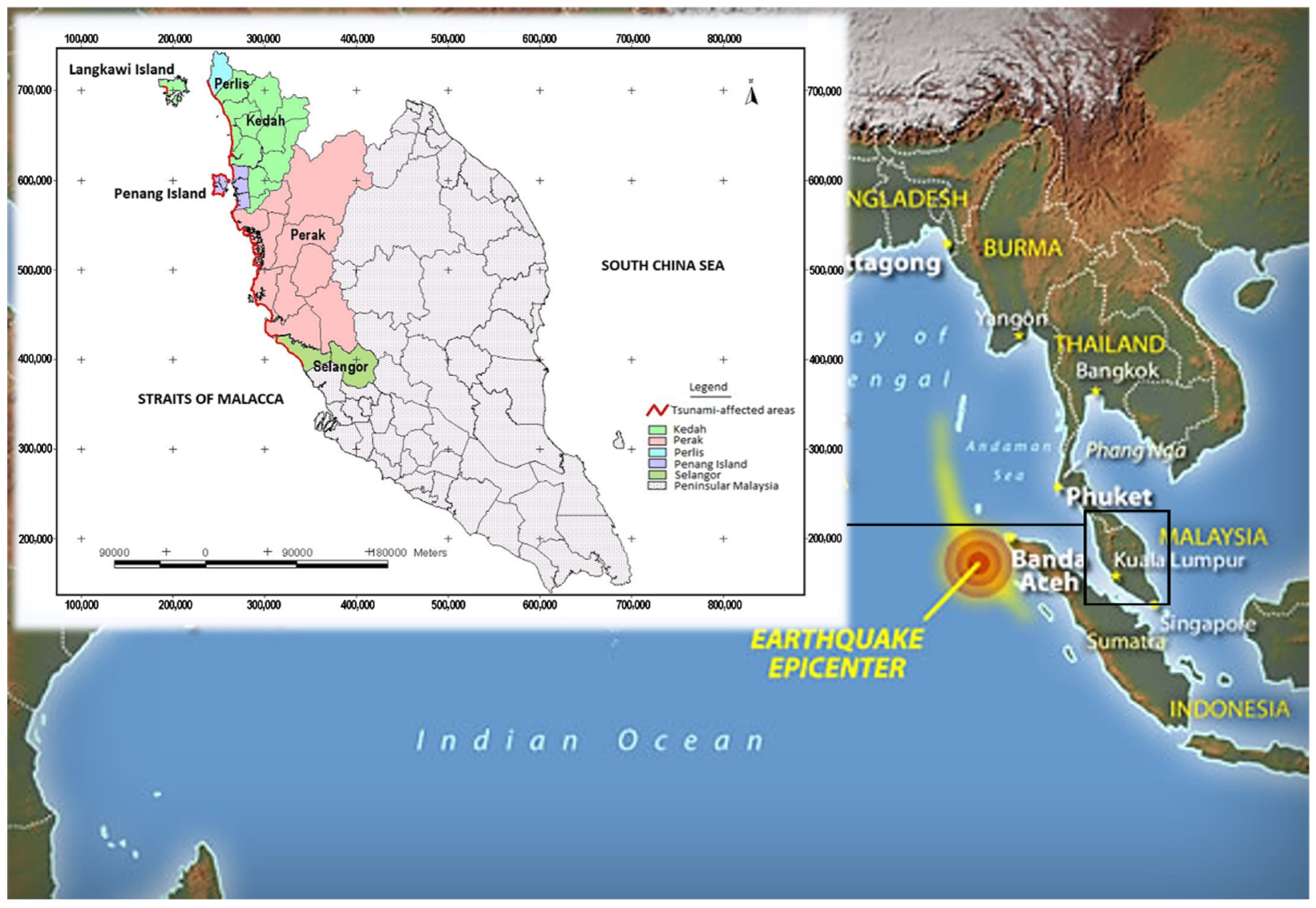
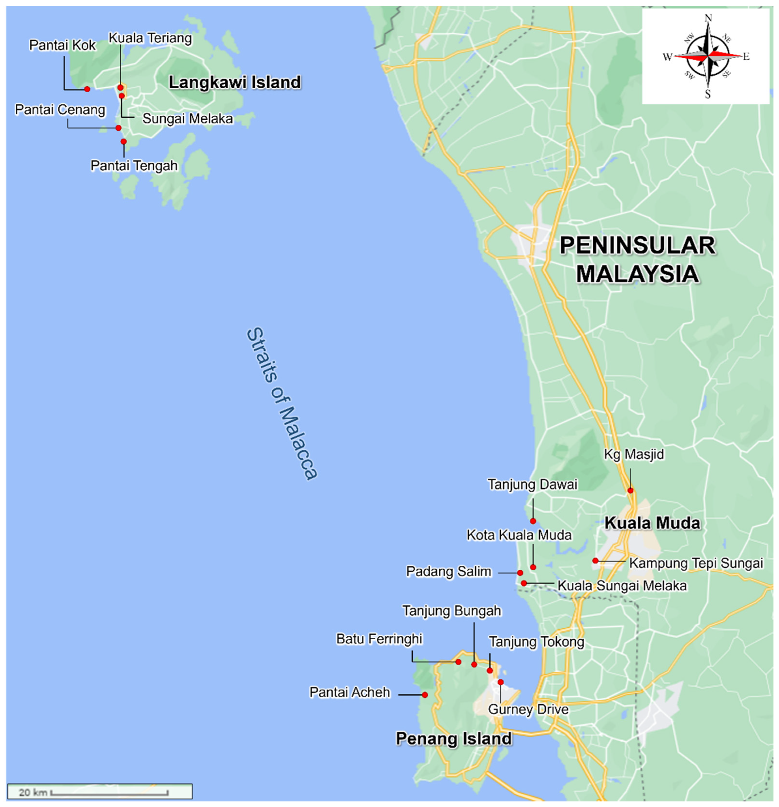
2. 2004 Indian Ocean Tsunami: Field Observations in Peninsular Malaysia

On 26 December 2004, the first-ever tsunami in Peninsular Malaysia was recorded in the modern history of Malaysia. Notwithstanding its proximity to the earthquake’s epicentre (west coast of northern Sumatra), Malaysia escaped the severe damages and casualties suffered by the neighbouring countries, including Sri Lanka, Thailand and Indonesia (particularly Banda Aceh). Although the 2004 tsunami event only affected those states in the northern half of the Straits of Malacca (as shown in Figure 1), this incident was considered one of the most critical disasters among the 39 disasters experienced in Malaysia from 1968 to 2004 [15] and the 51 natural disaster events from 1998 to 2018 [16]. It brought both short- and long-term sequelae to the locals, including physical, environmental, socio-economical and even psychosocial impacts [17,18]. This review thus gathers field-investigated data in the following sub-sections, focusing on the tsunami’s characteristics and the building damage in the inundation zones at different tsunami-affected locations. The summarized information could provide additional knowledge to coastal communities on tsunami-related topics.
Figure 1. Coastlines of Peninsular Malaysia affected by 2004 Indian Ocean tsunami [17].
Jmse 10 01088 g001

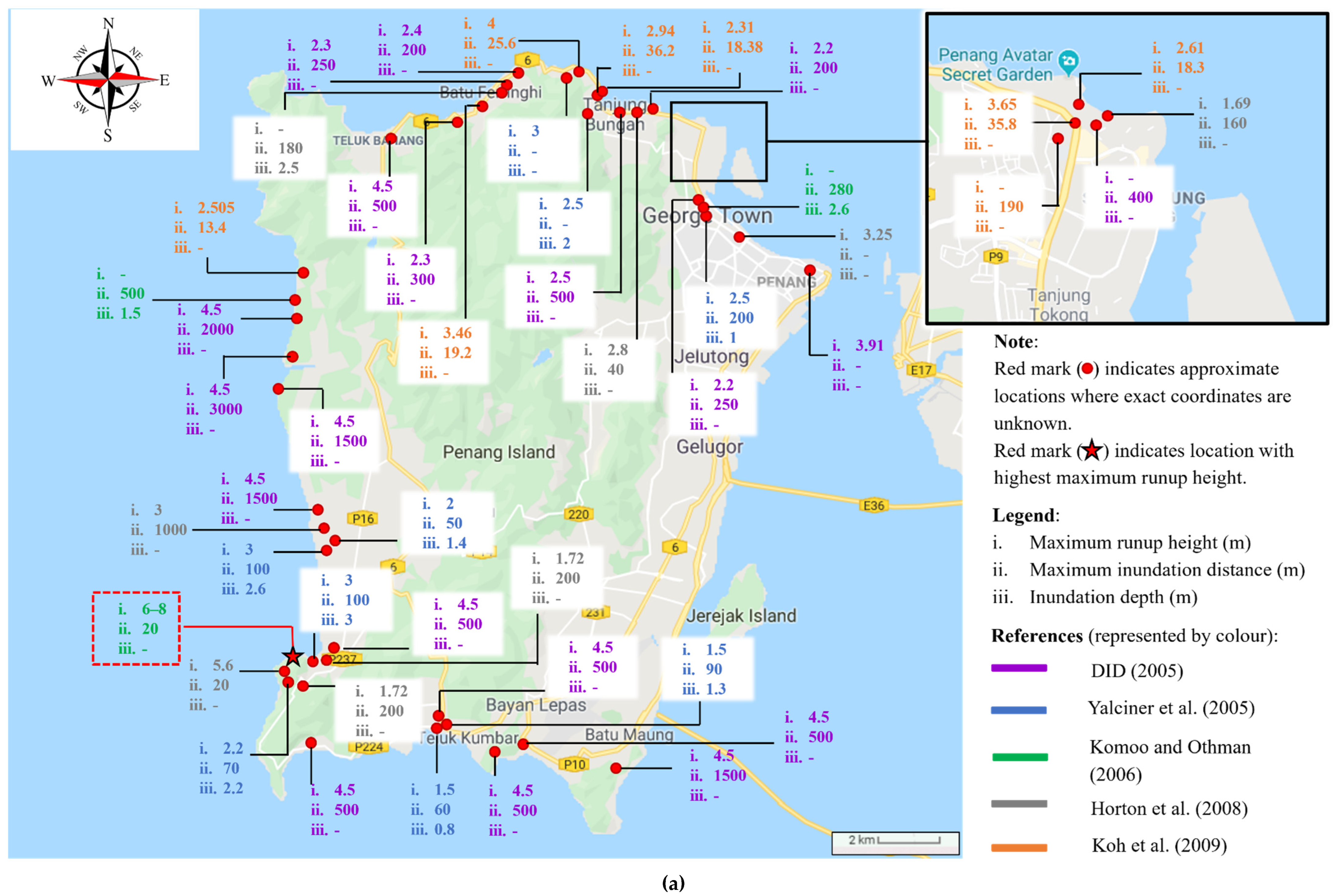
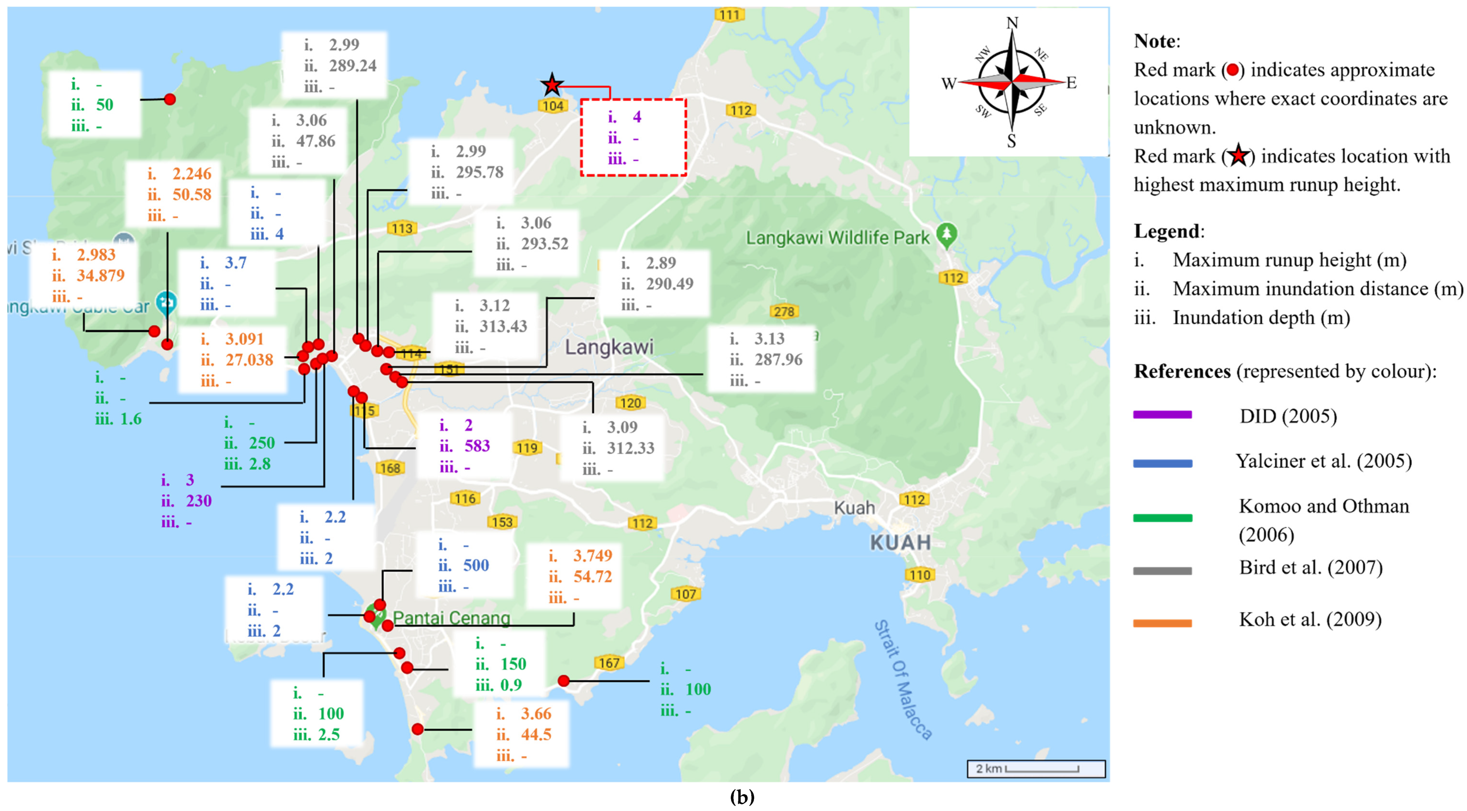
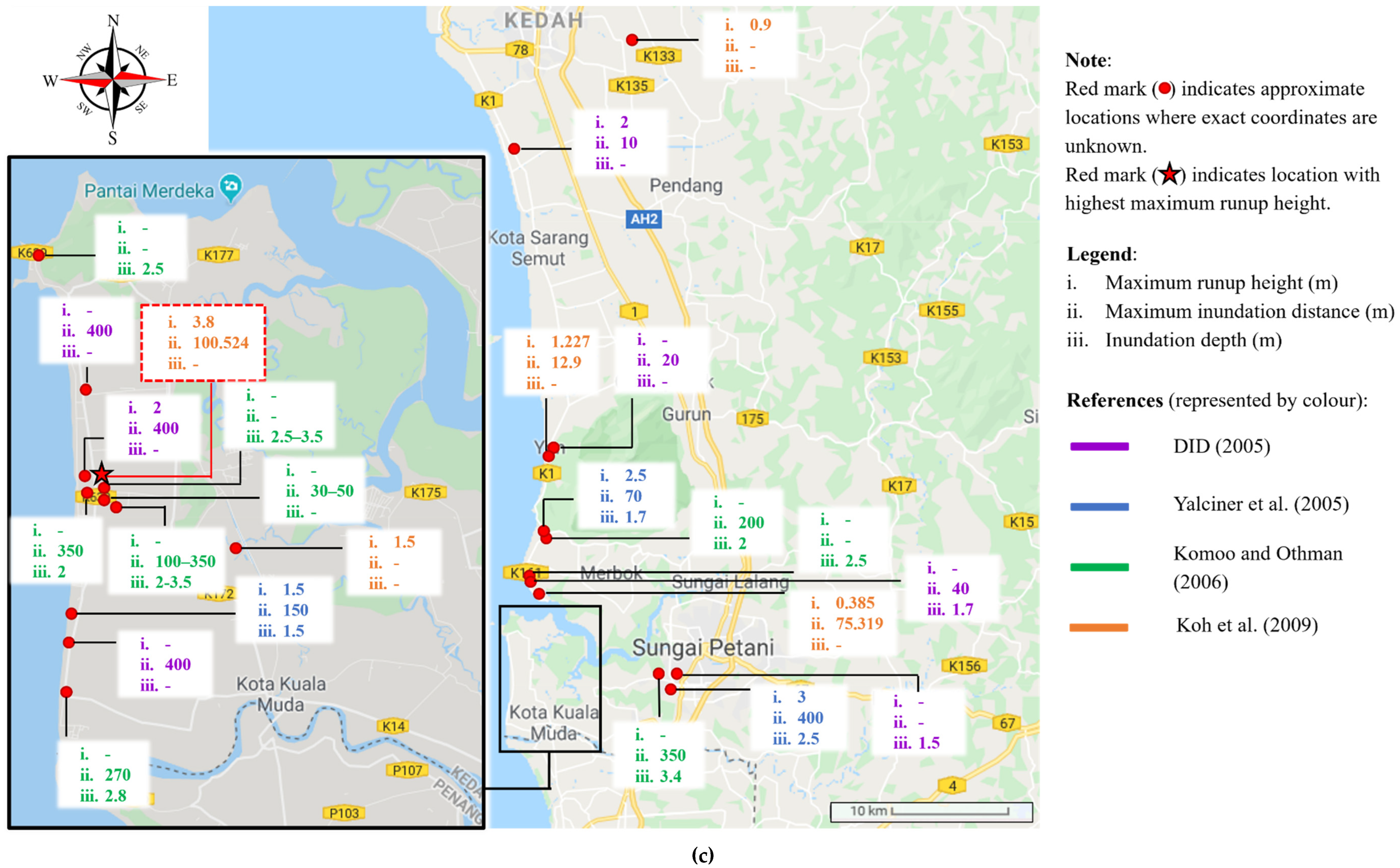
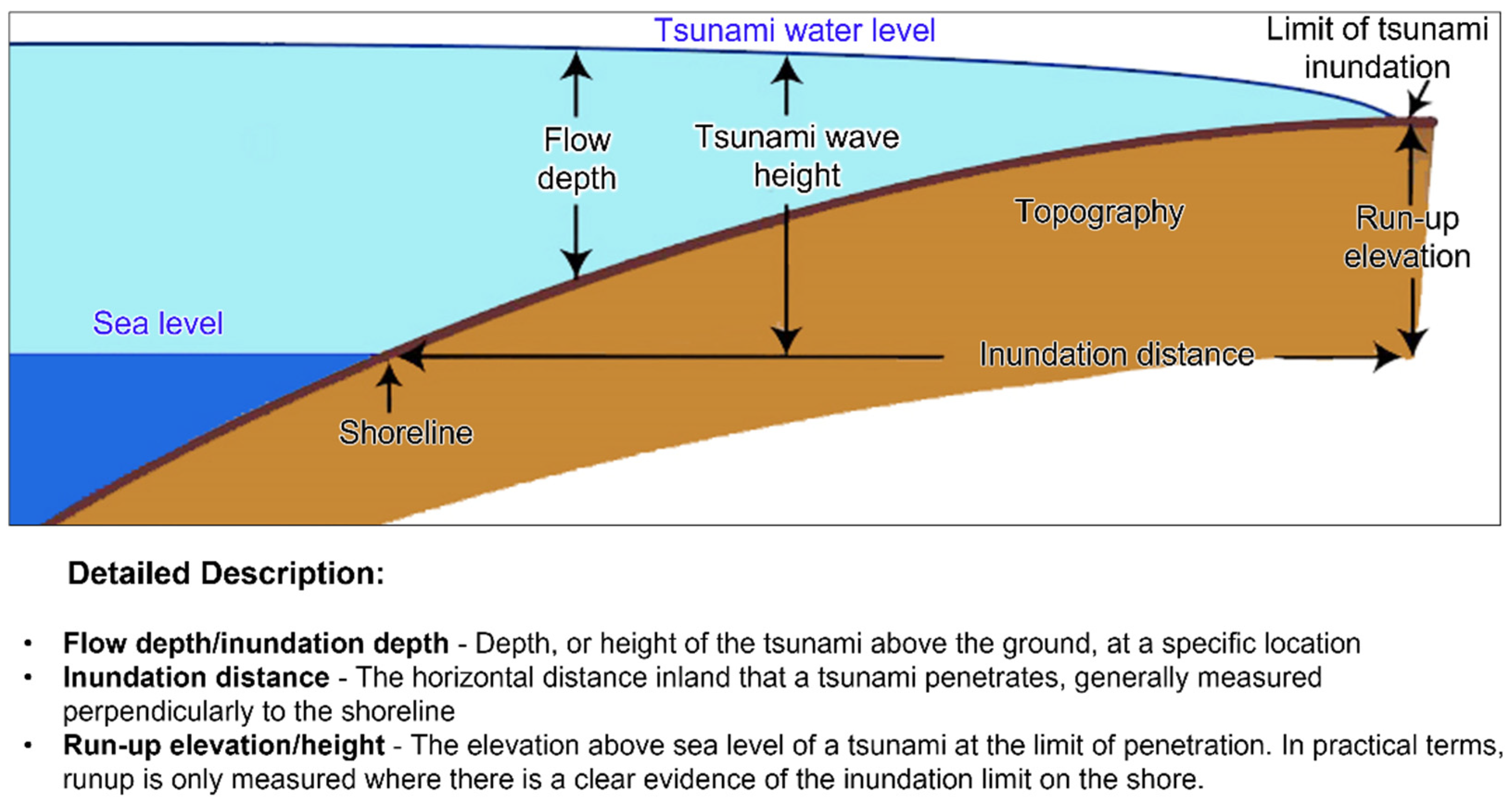
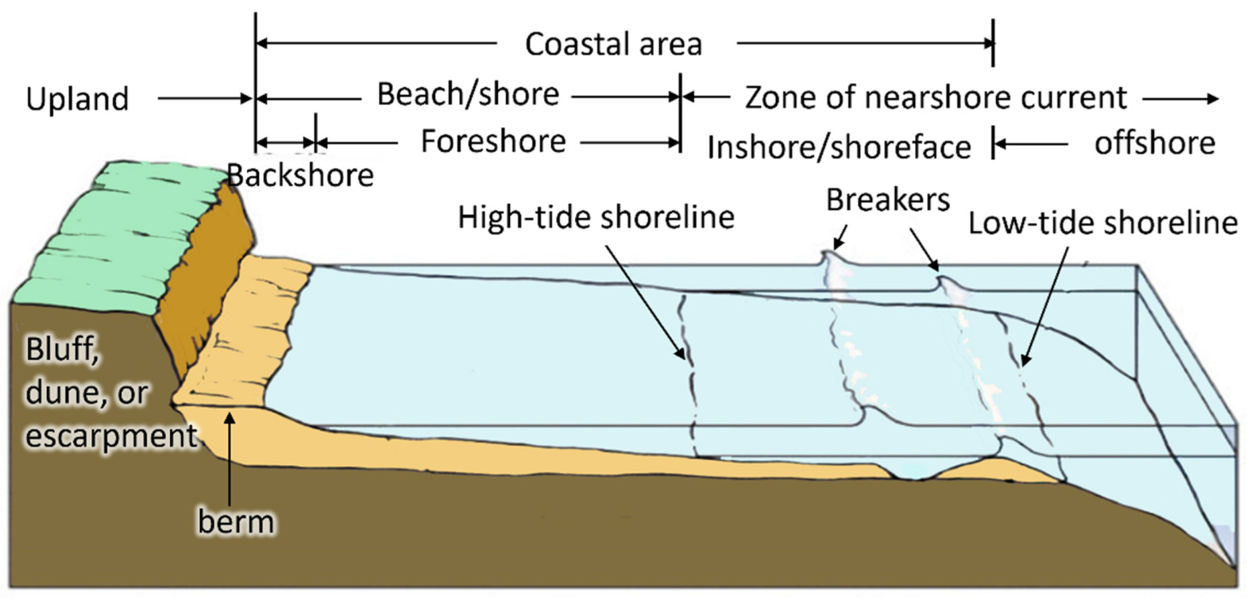
2.1. Tsunami Characteristics

In Malaysia, the major tsunami-affected areas were the northern coastal areas, particularly Kuala Muda and the outlying islands (Penang Island and Langkawi Island). As shown in Figure 2, five locations each on Penang Island (Batu Ferringhi, Tanjung Tokong, Tanjung Bungah, Pantai Acheh and Gurney Drive) and Langkawi Island (Pantai Tengah, Pantai Cenang, Kuala Teriang, Pantai Kok and Sungai Melaka), and six major locations in Kuala Muda (Kota Kuala Muda, Tanjung Dawai, Kuala Sungai Muda, Kampung Tepi Sungai, Kg Masjid and Padang Salim) were badly hit by the 2004 Indian Ocean tsunami. It is reported by Yalciner et al. [19] and Bird et al. [20] that the waves first reached Langkawi Island slightly more than 3 h after the earthquake, with an average speed of 240 km/h and nearshore positive amplitudes ranging from 2.5 m to 3.0 m. The waves subsequently travelled south to Penang Island with average nearshore positive amplitudes ranging between 2.0 m to 3.0 m, while a lower speed of approximately 100 km/h occurred across the Straits of Malacca due to the shallower sea depth [21].
Field-investigated data are critical to the fundamental understanding of tsunami generation and propagation as well as the coastal impacts. Subsequent to the 2004 Indian Ocean tsunami, post-disaster surveys and case studies were extensively conducted at Penang Island, Langkawi Island and Kuala Muda [19,20,21,22,23,24]. The variability of tsunami flow characteristics is based on a site-specific basis in terms of geomorphic setting. Thus, the tsunami wave parameters from observations such as the maximum runup height, inundation distance and inundation depth are graphically summarized in Figure 3, which could be helpful as a benchmark for the validation of tsunami inundation models. The definitions of those tsunami parameters (as noted in the Tsunami Glossary [25]) are given in Appendix A (Figure A1).
The findings compiled in Figure 3 show that the maximum runup reached as high as 6–8 m (Pasir Panjang), 4 m (Teluk Ewa) and 3.8 m (Kota Kuala Muda) at Penang Island, Langkawi Island and Kuala Muda, respectively. As reported, the maximum tsunami inundation ranged from 13 m to 3000 m, depending on the ocean bathymetry, topography, hydrology and geology of the coast [11]. The terminology in coastal zones, as noted by FEMA P-55 [26], can be found in Appendix A (Figure A2). The variability is also attributed to tsunami barriers or other coastal protection structures. In Malaysia, the man-made offshore breakwaters and seawalls along the coastline in the south of Kuala Teriang did help to reduce the tsunami wave inundations [19,22,27]. However, Lee et al. [28] reported that certain landward areas in Kampung Kuala Teriang still failed to be protected by those man-made structures. On the other hand, the wave energy was successfully dissipated by natural barriers such as the mangrove forests found at Pantai Acheh, resulting in a runup height of less than 4 m [23]. The northern parts of Langkawi Island (Kampung Kubang Badak) and Kuala Muda (Kampung Pulau Sayak) also suffered less impact, as they were shielded by mangrove forests [28,29].
As for the flow velocity, there is limited relevant information recorded for the 2004 tsunami event in Peninsular Malaysia. Table 2 summarizes the recorded flow velocity for the wave approaching the northwestern part of Peninsular Malaysia during the 2004 Indian Ocean tsunami. Komoo and Othman [24] reported that the flow velocity for the wave approaching Kuala Muda was approximately 8.33 m/s, whereas a flow velocity of approximately 18.06 m/s was observed for Penang Island and Langkawi Island (Table 2). This observation is somewhat contrary to the study of Bird et al. [20], which reported a much lower flow velocity of 6.94 m/s near Sungai Kuala Triang in Langkawi Island.
Table 2. Recorded flow velocity for 2004 Indian Ocean tsunami approaching Peninsular Malaysia.
ReferencesIncident PlaceFlow Velocity (m/s)
Bird et al. [20]Sungai Kuala Triang, Langkawi Island (6.328258, 99.847767)6.94
Komoo and Othman [24]Kota Kuala Muda8.33
Figure 3. Mapping of maximum wave runup, inundation distance and inundation depth in Peninsular Malaysia during the 2004 Indian Ocean tsunami (source: Google Maps) [19,20,21,22,23,24]. (a) Penang Island. (b) Langkawi Island. (c) Kuala Muda.
Jmse 10 01088 g003aJmse 10 01088 g003bJmse 10 01088 g003c

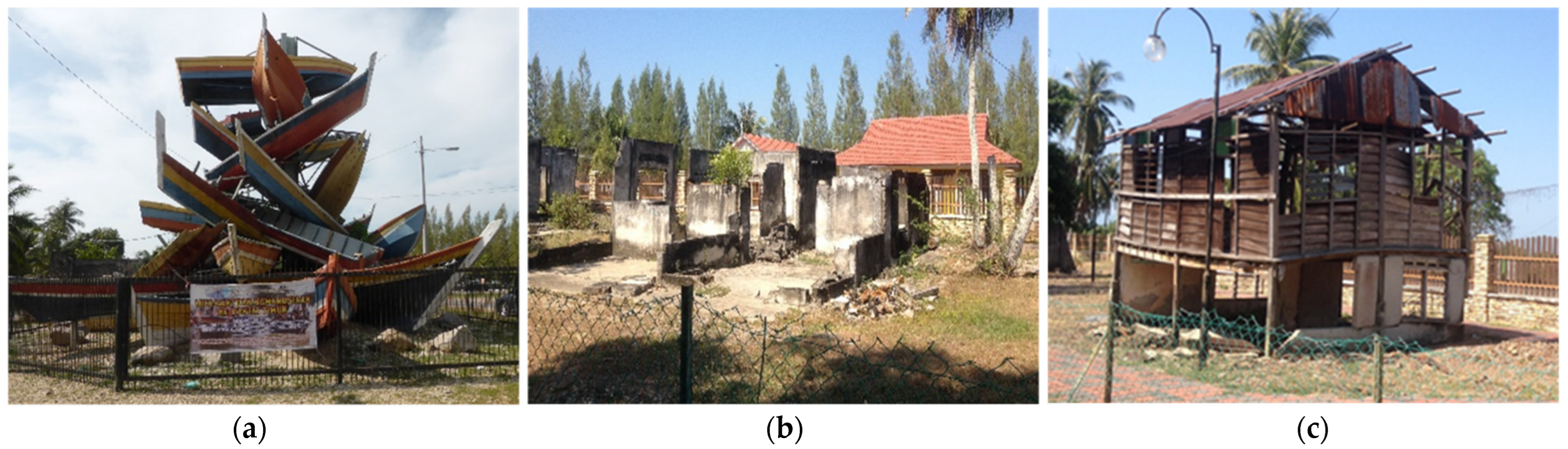
2.2. Building Damage

According to the Department of Irrigation and Drainage (DID), a total of 1535 residential buildings in Malaysia—in Kedah (900), Penang Island (615) and Perak (20)—were damaged or destroyed during the 2004 tsunami event [22]. The affected buildings were classified into wooden/timber houses, masonry houses and combination wooden and masonry houses. Kedah (particularly the Kuala Muda region) was deemed one of the most severely affected areas among the affected states of Malaysia. Apart from its low-lying coastline, most of the houses in Kuala Muda were made of highly vulnerable wooden frames made up of columns and beams which were supported closely by spaced joists. Figure 4a shows the Kota Kuala Muda Tsunami Memorial built next to a row of damaged houses left in their wrecked condition as a reminder of the destructive natural forces.
Regarding the aspect of structural damage, buildings with different structural systems and construction materials suffered different extents of destruction. Based on the surveyed data, as in DID [22], Komoo and Othman [24] and Nordin and Charleson [30], such damage modes as wall failure, total collapse, debris impact and tilting of structures were commonly observed along the northwest coast of Malaysia. Accordingly, both wooden and masonry houses suffered wall failure when impacted by tsunami waves. The wall panels of those wooden houses suffered enormous damage as the strong surges completely washed them away and consequently lifted and swept away floors and roofs as well. On the other hand, though most of the masonry houses managed to stand intact, their frontal faces suffered severe damage, owing to the direct exposure of their large surface areas to tsunami waves. Some portions of roof tiles were also found to be damaged by wave-induced uplift forces. The worst possible scenario is the wall blowout, as shown in Figure 4b. This phenomenon shows that hydrodynamic forces act on both the exterior and interior wall panels during the tsunami flows through a building.
Collapse is the most common failure observed for wooden houses. Often, little is left of the wooden constructions after they are subjected to the wave-induced loads [31]. Those constructions are vulnerable to the waves’ hydrostatic and hydrodynamic forces, though they resist earthquake loadings with minor damage. As a sequela of extreme hydrodynamic events like tsunamis, wooden houses were easily disintegrated into the sub-structures and were washed away as waterborne debris. Furthermore, some masonry houses located along the beaches of Kampung Masjid and Kampung Tepi Sungai in Kedah were also found to have collapsed, which could be attributed to lower structural strength, as the masonry houses are non-engineered lightly reinforced concrete (RC) buildings. Collapse generally occurs once the wave-induced loads exceed the load-carrying capacity of a building, especially when there is no coastal protection along the coastline.
Tsunami loads might become more destructive with mud-laden waves and debris resulting from vehicles and failed building components such as wall panels, windows and roofs. With each passing cycle of inflow and outflow, the amount of debris could increase as the waves sweep everything present in the inundation zones [32]. This kind of destruction was apparently reported on Langkawi Island and Penang Island [20,21]. During the 2004 tsunami occurrence in Peninsular Malaysia, the debris of floating vehicles was carried by the tsunami flow and was deposited at houses. When a wave carrying large-scale debris surged toward the houses, the houses were laden with debris and subsequently experienced severe damage to exterior walls and structural columns, as well as beams.
Another failure mode was observed in Kota Kuala Muda: tilting of structures, as shown in Figure 4c. This scenario mainly involves traditionally designed Malay houses with a combination of wooden and masonry structures. Such traditional houses survived in the 2004 tsunami event, as their elevated design provided enough space for low tsunami waves to go underneath, and thus the first floor was hardly affected [30]. For this kind of structure, the piers and house-to-stump connections play essential roles in resisting the waves and debris impact. Due to the failure of columns on the ground floor, the whole structure was tilted, associated with large deformation (Figure 4c). However, the damage experienced by an elevated house is said to be significantly related to the tsunami inundation depth. The whole structure could be destroyed in the worst scenario where the inundation depth is high enough to reach the first floor.
The Malaysian government commenced post-disaster rehabilitation and reconstruction in the immediate aftermath of the disaster. Other than the financial aid, temporary housing of timber and steel longhouses was constructed to provide safe shelter for about 104 affected families whose houses were no longer inhabitable [33,34]. A new town development plan with permanent housing was then undertaken by the national housing development company (SPNB), owned by the minister of finance of Malaysia, to relocate the tsunami victims. Under the “Rumah Mesra Rakyat” (RMR) Program, 561 new permanent houses were built in Penang State (Pangsapuri Masjid Terapung in Tanjung Bungah, Desa Kuala Muda in Seberang Perai), and 166 others were built in Kedah State (Taman Ara Jaya in Langkawi, Taman Permatang Katong in Kota Kuala Muda) [35]. This emergency housing has been met with great satisfaction among the affected communities in Kota Kuala Muda.

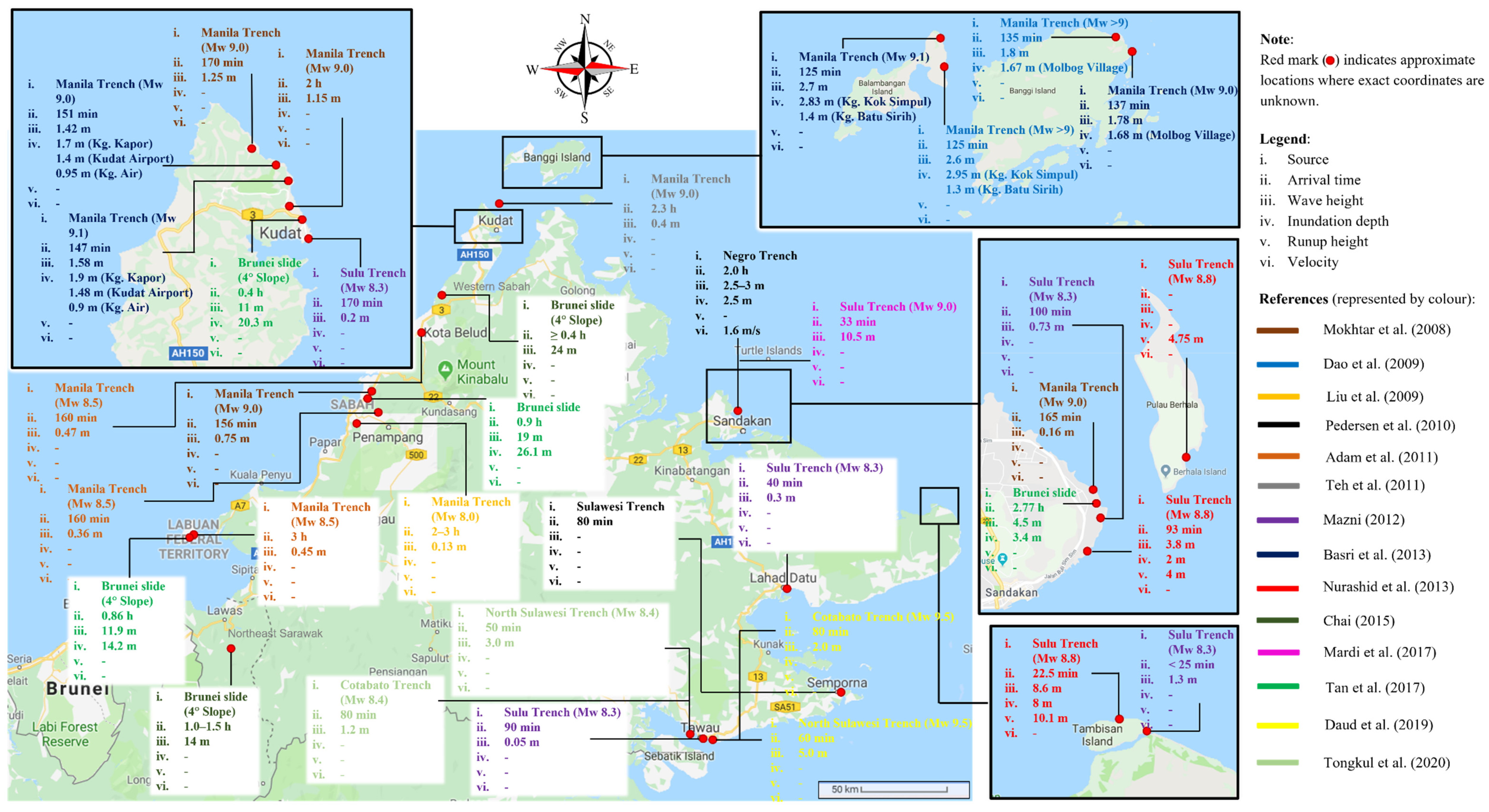
3. Assessment of Tsunami Threats to the Coast of Malaysia

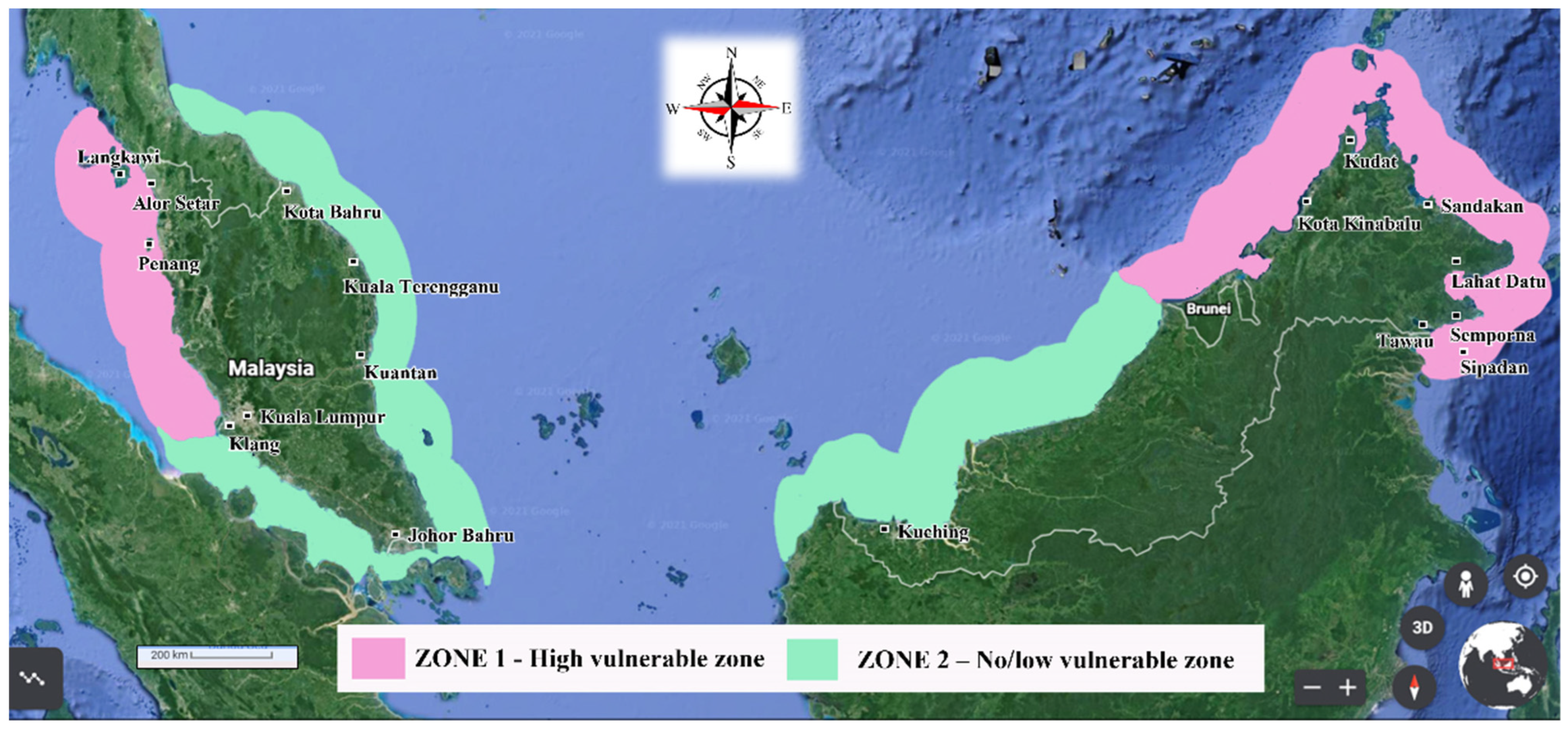
3.1. Tsunami Hazard Zoning

In the foreseeable future, tsunamis will likely threaten Malaysian coastal dwellings [36]. Based on the tectonics of the Southeast Asia region, the Malaysia region is situated on the Sunda Plate, bordered by seismically active areas. In the assessment of tsunami threats to Malaysia, significant uncertainties exist regarding the potential tsunamigenic earthquake sources originating from the Andaman Nicobar Islands fault slip zone, Philippine subduction zones, the South China Sea (SCS), the Sulawesi Sea and the Makassar Strait [36].
In 2009, the Ministry of Science, Technology and Innovation (MOSTI) initiated the development of a tsunami hazard map for Malaysia (Figure 5) based on the above-mentioned potential sources. According to the tsunami hazard zones depicted in Figure 5, not all parts of Malaysia will have the same degree of tsunami risk. The risk areas can be sub-divided into two zones of different degrees of risk: Zone 1 can be defined as the high vulnerable hazard zone, covering the northwestern part of Peninsular Malaysia (Perlis, Penang, Kedah, Perak and Selangor) as well as the northeast, northwest and southwest coasts of Sabah (Kudat, Kota Kinabalu, Sandakan, Lahat Datu, Semporna, Tawau and Sipadan), whereas Zone 2 possesses no or very low tsunami hazard, covering the remaining coastal areas in Malaysia. Note that Sabah is a Malaysian state located in East Malaysia.
Figure 5. Tsunami hazard zoning for Malaysia [36].
Jmse 10 01088 g005

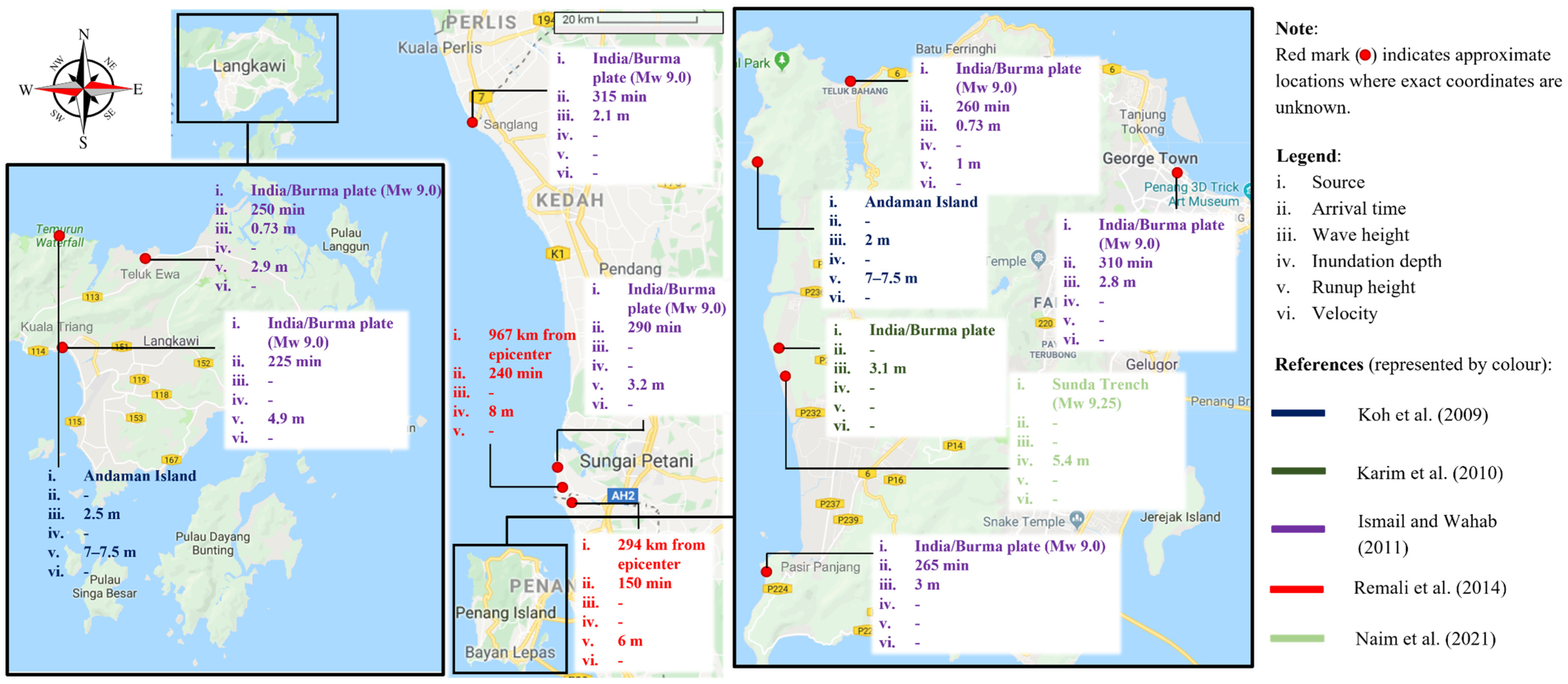
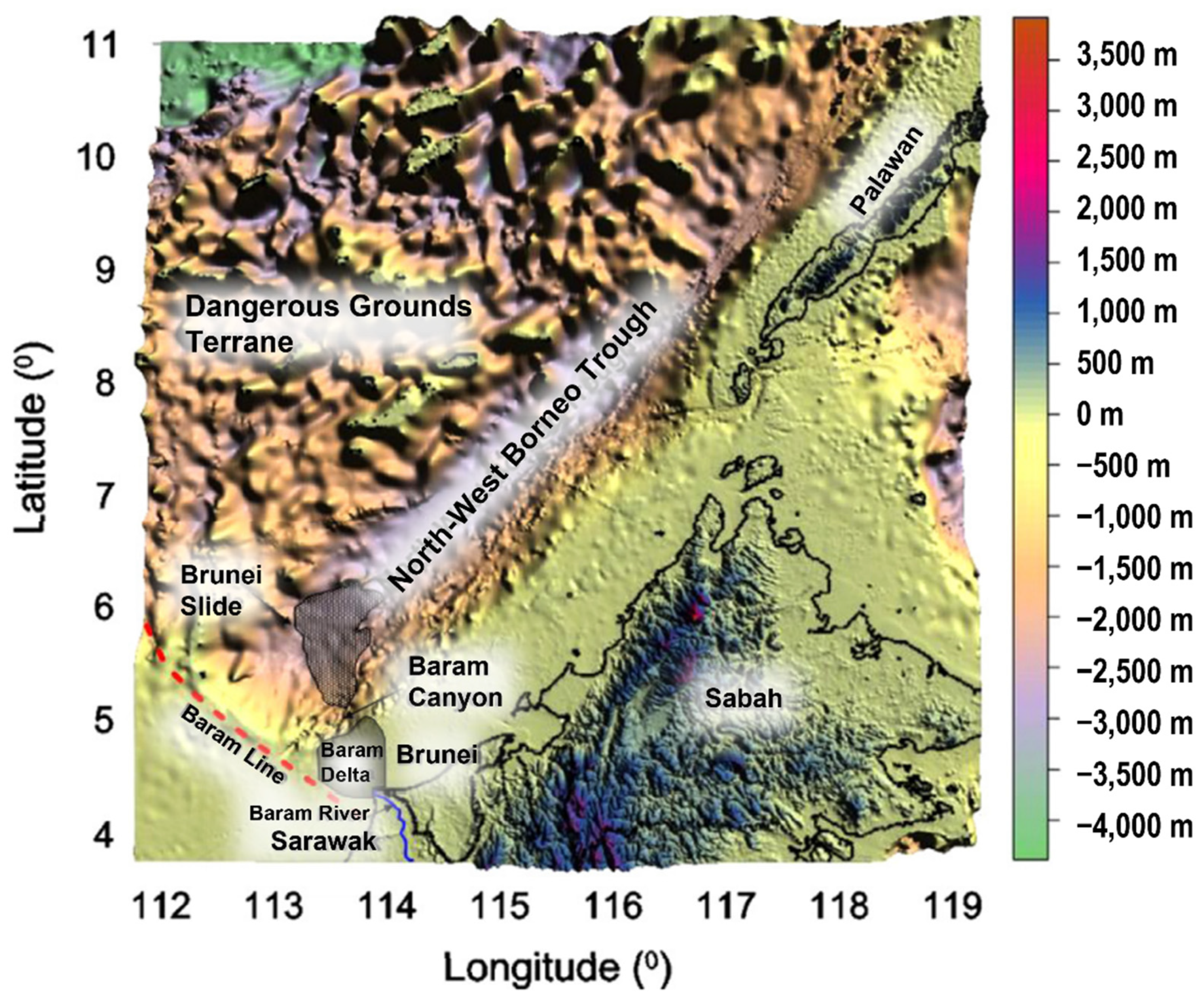
3.2. Worst-Case Scenario Simulation

Although the established tsunami warning systems could save lives through the early evacuation of residents, understanding inundation scenarios is crucial to resilience preparation. Following the 2004 tsunami event, great efforts by means of computational simulations have been seen, focusing on the three main phases of tsunami dynamics: generation, propagation and runup. According to the literature, tsunami simulations are commonly performed using the following well-known models: the COMCOT (Cornell Multi-grid Coupled Tsunami model), TUNAMI, TUNAMI-N2, TUNAMI-N2-NUS (Tohoku University’s Numerical Analysis Model for Investigation of the Near-field tsunami), TDP (Tsunami Display Program model), TUNA, TUNA-M2, TUNA-RP (Tsunami-tracking Utilities and Application) and MIKE 21 flow model, developed by the Danish Hydraulic Institute (DHI).
Prior to the investigation of potential worst-case events, the scenario of the 2004 tsunami generation and propagation towards Malaysia was first reconstructed, and the simulation results were compared with the post-tsunami observations [23,37,38,39,40,41,42]. The study of Ghazali et al. [43] suggested the possibility of a 2004 tsunami scenario coinciding with the highest astronomical tide (HAT) event that would double the tsunami incident waves and inshore penetration observed in 2004. Apart from the simulation based on the tsunami back in 2004, other extensive tsunami modelling efforts with multiple scenarios and possible sources have also been undertaken to identify the locations at risk. The findings from the worst-case scenarios of future tsunamis striking the Malaysian shores (Peninsular Malaysia (particularly Perlis, Kedah and Penang Island) and East Malaysia (particularly Sabah)) were compiled in this study, as systemically presented in Figure 6 and Figure 7, respectively. The forecasted key parameters include the tsunami arrival times, wave heights, inundation depths, runup heights and flow velocities to which coastal communities would be subjected.
Based on historical earthquake data along the Indian/Burma Plate, Ismail and Wahab [44] and Karim et al. [45] assessed the tsunami threat along the northwest coast of Peninsular Malaysia. Considering an earthquake magnitude (Mw) of 9.0, Kuala Triang received the highest tsunami level of around 5 m above the MSL. As evident from the worst-case scenario simulation, the other possible affected areas in Peninsular Malaysia include Teluk Bahang, Pasir Panjang and Georgetown in Penang Island, Kuala Triang and Teluk Ewa in Langkawi Island, Kuala Muda and Kuala Sanglang (Figure 6). Apart from the threat imposed from the Indian Ocean (Indian/Burma Plate), Koh et al. [23] demonstrated the severe impacts caused by tsunamigenic earthquakes at the Sumatra–Andaman fault, which might result in runups as high as 7.5 m at Langkawi Island and Penang Island (Figure 6). The recent study of Naim et al. [46] attempted to revise inundation results due to coastal changes and the availability of better topographic data. The latest findings show that Penang Island would be susceptible to being inundated 3.47 km inland to a depth of 5.40 m, triggered by earthquakes of Mw 9.25 along the Sunda Trench. There are also potential tsunami sources in the SCS due to the fault rupture along the Manila Trench near the Philippines affecting the east coast of Peninsular Malaysia, especially the states of Kelantan and Terengganu [47].
As for East Malaysia, the earliest study of Raj [48] reported that the coastal areas of Sabah generally possess an insignificant tsunami threat. However, subsequent studies have demonstrated the tsunami risk originating from the Manila Trench [49,50,51,52,53,54], Sulu Trench in the Sulu Sea [55,56,57], North Sulawesi Trench in the Celebes Sea [58] and Cotabato Trench [59,60]. Based on the worst-case scenario findings as summarized in Figure 7, the affected areas include Tambisan Island, Sandakan, Berhala Island, Kudat, Lahat Datu, Tawau, Kota Kinabalu, Kota Belud, Labuan, Balambangan Island, Banggi Island and Semporna. Based on the study of Nurashid et al. [56], the first wave hit Tambisan Island about 22 min after the earthquake occurrence at Sulu Trench, in which the maximum inundation depth reached 8 m following an 8.8 magnitude earthquake. Pedersen et al. [58] also identified the potentiality of the Negro Trench generating tsunamis with a maximum wave of 3 m (along the coastline) that would strike the northern tip of Sabah.
In 2007, a giant potential landslide tsunami source was identified near the North-West Borneo Trough, the so-called “Brunei slide”, as shown in Figure 8. To investigate its potential tsunami hazards towards Malaysia, Chai [61] and Tan et al. [62] computed a Brunei landslide tsunami simulation using the non-deforming submarine landslide model suggested by Watts et al. [63]. According to their studies, the Brunei slide-induced tsunami inundation distance might reach up to 2.64 km in Kota Kinabalu if the sliding slope is a 4° slope. In addition to the western region of Sabah, the coastal land of Sarawak (a Malaysian state located in the southwestern part of East Malaysia) could also be badly affected, with the inundation depth and distance potentially reaching 15.5 m and 4.86 km, respectively, for the worst scenario of a Brunei slide with a 4° sliding slope [62]. The later study of Ren et al. [64] also proved that not only Malaysia but also the coasts of Brunei, Indonesia, Vietnam, the Philippines and South China could be struck by Brunei slide-induced tsunamis as well. These findings are contrary to the hazard zones identified by the MOSTI [36] in Figure 5, which state that the coast of Sarawak possesses a low tsunami hazard. The MOSTI needs to continue improving and updating the current tsunami hazard map by including the Brunei slide as a potential tsunami source, as landslide tsunamis have been receiving more attention in recent years.
Figure 6. Mapping of tsunami source, arrival time, wave height, inundation depth, runup height and velocity for future tsunami occurrence in the states of Perlis, Kedah and Penang Island (source: Google Maps) [23,37,44,45,46].
Jmse 10 01088 g006
Figure 7. Mapping of tsunami source, arrival time, wave height, inundation depth, runup height and velocity for future tsunami occurrence in the state of Sabah (source: Google Maps) [49,50,51,52,53,54,55,56,57,58,59,60,61,62].
Jmse 10 01088 g007
Figure 8. Location of the Brunei slide in the North-West Borneo Trough with ocean bottom profiles [61].
Jmse 10 01088 g008
According to numerical simulations by various researchers, the hypothetical future tsunamis would likely cause adverse impacts to coastal areas in Malaysia. It is noteworthy to mention that casualties could possibly increase due to a lack of awareness of tsunami hazards. Thus, the graphical summaries depicted in Figure 6 and Figure 7 are necessary to raise community awareness of tsunami occurrence near those regions, though it is not possible to predict the timeframe of the next tsunami that will hit those areas.

4. Post-2004 Measures and Research in Malaysia

4.1. Disaster Risk Management

Following lessons from the 2004 tsunami, the Malaysian government has undertaken various measures and strategies to respond to disaster management’s preparedness, response and recovery phases. Inspired by the United States National Tsunami Hazard Mitigation Program (NTHMP), a series of South China Sea Tsunami Workshops (SCSTW) was initiated as a platform in 2007 to gather worldwide tsunami experts to discuss discoveries and understandings of tsunami-related hazards. In 2009, the SCSTW-3 was successfully held in Malaysia, receiving contributions from organizations from 30 nations, including the United States Geological Survey (USGS), Academia Sinica Taipei, Tohoku University International Research Institute of Disaster Science (IRIDeS) and Philippine Institute of Volcanology and Seismology (PHIVOLCS) [65]. The published special issue [66,67] on the workshop’s multi-disciplinary findings was necessary for strengthening coastal community resilience.
As part of the government’s efforts to mitigate future tsunami risk, the Malaysian National Tsunami Early Warning System (MNTEWS) was established in December 2005 as a national monitoring centre carrying three main functions: data collection, data processing and analysis, as well as warning dissemination through various media, including the Fixed-Line Alert System (FLAS), Short Message Service (SMS), media broadcast (TV, radio), social media (Facebook, Twitter), official Malaysian Meteorological Department (MMD) portals and public announcement systems (sirens/PA) [68]. As of 2017, the sea level network in Malaysia was made up of one deep-ocean buoy deployed near Layang-Layang Island in the SCS, together with 17 tide gauge stations, with 8 in Peninsular Malaysia (Awana Porto Malai, Perak Island, Kerachut, Perhentian Island, Jarak Island, Tanjung Keling, Tanjung Gelang and Tioman Island), 6 in Sabah (Kudat, Sepanggar, Layang-layang Island, Lahad Datu, Labuan and Tawau) and 3 in Sarawak (Mukah, Bintulu and Miri). The MNTEWS is also an integral part of the Indian Ocean Tsunami Warning System and the Northwest Pacific Advisory System coordinated by the Intergovernmental Oceanographic Commission (IOC) of UNESCO, enabling the provision of effective early warnings of tsunami occurrence over the Indian Ocean, SCS, Sulu Sea and Pacific Ocean [69]. It is also worth mentioning that the South China Sea Tsunami Advisory Centre (SCSTAC) coordinated by UNESCO’s IOC became operational in 2019 [70]. At present, the SCSTAC consists of three groups (the Earthquake Monitoring Group, Tsunami Warning Group and Tsunami Mitigation Group), with the primary mission of providing timely advisories on potentially destructive tsunamis to Brunei, Cambodia, the People’s Republic of China, Indonesia, Malaysia, the Philippines, Singapore, Thailand and Vietnam.
On 18 March 2015, Malaysia ratified the Sendai Framework for Disaster Risk Reduction (SFDRR) 2015–2030 alongside other 187 United Nation members [71]. Under the fourth priority of SFDRR, standard operating procedures (SOP) have been developed for each type of disaster response, including tsunamis [72]. Based on surveys conducted by Zahari et al. [73], local communities were found to be ideal for preparing for future tsunamis. The country thus adopted the community-based disaster preparedness (CBDP) approach to encourage community involvement in disaster management. Public awareness programs such as posters and public workshops are also an integral part of the MNTEWS, with the close cooperation of the National Disaster Management Agency (NADMA) and the Malaysian Meteorological Department. To better enhance local preparedness for disaster, the Inter-Agency Committee for Earthquake and Tsunami Risk Management (IACETRM) was also formed to utilize the CBDP approach in developing TERPs for local communities [69]. Through the coordination of the Academy of Sciences Malaysia (ASM), TERPs were first developed for Langkawi Island, followed by Kuala Muda, Penang Island (Batu Ferringhi and Balik Pulau) and the Kudat District in Sabah. This approach has been found to be more effective if other vulnerable communities also receive similar endeavours, as a priority at least, in the high threat-level zones, as mentioned in Section 3.
Since the 2004 tsunami, governments and communities across Asia-Pacific have increased awareness of the issue. The United Nations Development Programme (UNDP) and the Japanese government have taken some initiatives on strengthening tsunami awareness and preparedness in 18 Asia-Pacific countries through a project called “Strengthening School Preparedness for Tsunamis in the Asia-Pacific Region”. As Malaysia is one of those selected countries, awareness campaigns and simulation exercises were conducted in 2018 by the UNDP in collaboration with the NADMA and the Ministry of Education (MOE) to prepare schools and communities for a tsunami [74]. Appropriate education and training programs were also designed and delivered to students and teachers through community-based disaster risk management (CBDRM) and the School Preparedness Programme’s Training of Trainers initiative, respectively. The lessons and experiences gained from the tsunami evacuation and safety drills could ensure the residents are well-equipped to deal with future tsunamis regarding response time and actions.

4.2. Studies on Coastal Protections

There have been many global studies covering the topic of coastal protections following the 2004 tsunami event [75,76,77,78,79]. In Malaysia, field surveys on Kuala Teriang, Langkawi Island, revealed that macroroughness in terms of breakwaters and seawalls effectively reduced potential tsunami risks [22]. In this context, Jahromi and Sidek [80] attempted the conceptualization of submerged structures as tsunami barriers. Thirty-nine different layouts of nearshore breakwaters were designed and tested using the Steady-State Spectral Wave (STWAVE) Module of the Surface Water Modelling System (SMS). Numerical results demonstrated a significant reduction in wave heights at the shoreline of up to 83% by the optimized layout of the submerged breakwaters while preserving the aesthetic feature of Penang Island as a tourist attraction spot.
Rahman et al. [81] conducted physical modelling to ascertain the reduction of tsunami wave force on a building fronted by a seawall; 1:35 scaled experiments were conducted in a wave flume that was 17.5 m long, 0.6 m wide and 0.45 m high. The presence of a seawall demonstrated the force reduction on the inland building. A dimensionless factor considering the distance from the gate to the seawall and the distance from the gate to the building was proposed, where the force reduction increases with an increasing ratio. Rahman et al. [81] also suggested that a seawall with perforations could allow water to easily flow back to the sea. Perforated seawalls were then tested by Maqtan et al. [82] and proved to minimize an overtopped wave and also reduce the scouring at the seawall’s landward toe.
Lately, research topics related to this field have gained considerable interest among Malaysian researchers. Ibrahim et al. [83] focused on wave transmission over an innovative submerged breakwater called the WABCORE (Wave Breaker and Coastal Restoration breakwater), a composite system unit developed by National Hydraulic Research Institute of Malaysia (NAHRIM). In the study, the WABCORE was arranged to result in two model types: narrow- and broad-crested structures. The experiments permitted the testing of each structure type in a series of incident waves with different heights (0.05, 0.10, 0.15, 0.20, 0.25 and 0.30 m) and periods (1.43, 1.68 and 2.0 s). By varying the freeboard (distance from top crest to the surface water level) from 0.02 m to 0.22 m, a wave transmission coefficient was successfully derived. In contrast, Pereira et al. [84] suggested using floating breakwaters as a potential mitigation against direct wave attacks. To reduce the environmental impacts posed by the submerged breakwaters, a few membrane-type floating breakwaters were developed, attaching to additional ballasting materials (water and sand). The findings revealed that the design with a lower and wider distributed configuration of ballasting was proven to effectively dissipate the wave energy, with a maximum difference of 20% compared to that of the rigid box-type model.
Instead of designing man-made structures as nearshore barriers, soft bio-engineering or environmental approaches (coastal vegetation) are gaining more popularity as potential mitigation measures against tsunamis due to their cost-effectiveness. The protective role of large-scale roughness elements such as mangroves has been observed in case studies [85], numerical simulations [86,87] and laboratory experiments [88]. From the study of Teh et al. [87], Manning’s roughness coefficient was incorporated in a TUNA-RP simulation to represent the mangrove forests at Pantai Acheh. The results showed that the simulated and surveyed runup heights were close compared to those without mangrove forests in the simulation. The findings are in agreement with Fateh et al. [89], which carried out a structural analysis to study the behaviour of buildings in terms of bending moment and shear force when subjected to tsunami loads. When the protection of coastal forests was provided, the bending moment and shear force for structures were reduced by 96% due to reduced wave heights.
Hashim and Catherine [88] conducted an initial laboratory study on the quantitative effect of various mangrove densities and tree arrangements on wave attenuation. In the laboratory tests, artificial Rhizophora tree models were downscaled at a ratio of 1:10 and subjected to tsunami waves in a 23 m long, 1.5 m wide and 1.2 m high wave flume. The experimental results demonstrated an insignificant effect of the mangrove tree arrangement on the wave height reduction, with a difference of less than 10%. Their study also suggested that 80 m wide mangrove forests with a density of 0.11 trees/m2 could be enough for coastal protection, where the wave height reduction can be up to approximately 80%. According to ADB [90], there is a total mangrove area of 575,000 hectares in Malaysia, of which 60% is in Sabah, followed by 23% in Sarawak and 17% in Peninsular Malaysia. As such, mangrove forests could be utilized to protect vulnerable shorelines from future tsunamis, provided these mangroves are planted in the right site conditions [91].

4.3. Studies on Tsunami Force Estimation

Over the past few decades, tsunami force estimation on structures has been studied and explored widely by tsunami-prone countries like Japan, the United States, China, Canada, the United Kingdom, New Zealand, Germany, Indonesia and India [92]. Malaysia, as one of the developing countries with little experience of tsunami occurrences, only embarked on experimental studies of structures against tsunami force in 2014 [93,94,95], thus leaving plenty of room for growth among local researchers. Ordinarily, the interaction between tsunami waves and a three-dimensional structure (building or bridge) is more complex than for a two-dimensional structure, particularly a wall. Moon et al. [93] were perhaps the first in Malaysia to experimentally study the interaction of tsunami waves with one- and two-storey onshore buildings. At a scale of 1:100, a recreation of the 2004 tsunami scenario at Penang Island was attempted in the study. As a preliminary study, Moon et al. [93] established the pressure–force relationship. Their work was further extended by Lau et al. [96], which modelled actual wave scenarios of 4, 6 and 8 m depths to represent historical and possible future tsunami events.
Efforts to investigate tsunami wave forces acting on bridges were also seen in 2014. Mazinani et al. [94] carried out a preliminary study to evaluate the tsunami-induced horizontal and uplift forces on a 1:40 scaled box girder bridge. The experimental data established a non-linear relationship between forces and wave heights. Based on the preliminary findings, Mazinani et al. [97] continued the work by conducting additional experiments with various girders and wave heights to assess the horizontal forces, uplift forces and overturning moment. The study then developed an alternative approach based on an extreme learning machine (ELM) predictive model to estimate the tsunami force on a bridge. In the Rahman et al. [95] study, a 1:100 scale bridge model with three girders was subjected to broken and unbroken waves. The static water depths were varied so that the forces could be evaluated through the clearance depth of the girder. The experimental results indicated that bridges with higher clearance depth were more vulnerable to tsunami hazards, where the maximum load was approximately 4.59 times the hydrostatic pressure for the case of a broken wave. Through its revision by Rahman and Khan [98], a predictive formula was proposed to estimate the horizontal wave pressure on a bridge, given a known wave height and the clearance depth of the girder.
Farahmandpour et al. [99] was perhaps the first and sole study in Malaysia that considered the impact of waterborne tsunami debris on structures. A dam-break mechanism was used to reproduce the tsunami wave, as the analogy between the propagation of a tsunami bore-front and dam-break flow was revealed by Chanson [100]. A 1:5 scale building model was subjected to wooden debris, which consisted of three pieces of wooden logs with different sizes and masses. All the wooden debris pieces were initially placed at the flume’s centreline with their sides parallel to the sides of the flume. Once the bore progressed downstream, it resulted in an impact against the building structure. The study showed a significant increase in the base shear force due to debris impact, as compared to the case with clear bore water. The experimentally measured debris impact forces were then compared with that calculated using the formula recommended by FEMA P-646 [101]. The comparison shows good agreement, especially in the case of bigger debris.
Under suitable scaling criteria, Teh et al. [102] also investigated wave pressure distribution on a vertical structure. Two types of fluids were used: Newtonian and non-Newtonian (kaolin clay suspension with a solid volumetric concentration of 20%), representing freshwater and mud-laden waves, respectively. For an equivalent reservoir water depth of 45 cm, the case of Newtonian fluid exhibited both bore height and velocity higher than the non-Newtonian one. These characteristics led to a larger surface flux being observed upon the wave’s impingement on the vertical structure. However, the pressure exerted at the bottom-most part of the structure was higher in the case of non-Newtonian fluid, associated with its higher viscous force. In the subsequent year, preliminary studies by Faisal et al. [103] pointed out the importance of openings in limiting wave-induced loads. Various wall-opening configurations were investigated regarding their abilities to reduce wave force on a building. According to the study, the elevation of openings was found to affect the wave velocity reduction. However, the results generally show that lesser force was induced on walls with bigger openings due to the smaller velocity reduction and diffusion when the flowing water passes through the wall. Efforts to investigate tsunami wave flow through a building can also be seen in the later study of Moon et al. [104].
Studies in 2019 were oriented toward estimating tsunami forces on seawalls [105] and buildings [106,107,108]. From the study of Nordin et al. [109], the layout of buildings was found to affect the tsunami flow travelling across the inundation zone. Moon et al. [106] thus evaluated the tsunami forces on a shielded building according to the macroroughness arranged in tandem and staggered orders. The findings demonstrated the influence of surrounding buildings on the tsunami flow mechanism. The resulting wave pressures were discussed in comparison to Thomas et al. [110] and Yang et al. [111]. In the same year, Moon et al. [107] investigated the effect of an elevated floor slab, intending to propose predictive equations for the estimation of tsunami forces on the front and back faces of an elevated building. The results agreed with Robertson et al. [112], FEMA P-646 [101] and Tomiczek et al. [113], where elevated structures suffered minor damage during past tsunami and hurricane events as compared to slab-on-grade structures located in the same vicinity. Motivated by the studies of Thusyanthan and Madabhushi [114] and Wilson et al. [115], the most recent study by Moon et al. [116] provided insights into the wave flow mechanisms and loading features associated with building roof types. The study attempted a hybrid approach, involving both experimental and numerical modelling through a 40 m long wave flume and a volume of fluid (VOF)-based model [117], respectively.

5. Challenges and Future Perspectives

The 2004 tsunami occurrence in Malaysia has undeniably led to the development of knowledge in disaster risk management in the country and mobilized experts’ involvement in the topic of tsunamis. Growing interest in tsunami-related research can be seen following government undertakings such as the Sea-to-Space (S2S) cluster cross-linking major departments, namely the National Space Agency, Malaysian Meteorological Department, Malaysian Centre for Remote Sensing, National Oceanography Directorate and Astronautic Technology (M) Sdn Bhd. However, although several efforts have been made, knowledge management remains a challenge in the country. In line with the Industrial Revolution 4.0, an IT-based system known as the knowledge management system (KMS) is the key enabler of knowledge management. An effective KMS is an urgent need in Malaysia to manage and share tacit and explicit knowledge in tsunami research among government departments, agencies, NGOs and research institutions [118,119].
In this review, the hazard assessment summarized herein indicated that future tsunami hazard exists, although Malaysia has never experienced succeeding tsunami disasters after the 2004 event. Over the years, urbanization near the Malaysian coastline has been ongoing rapidly, as is evident from the loss of approximately 2308 hectares of mangroves since 2012 [120]. To achieve better resilience in planning mitigation measures, it is necessary to have a complete tsunami hazard, vulnerability and risk assessment based on high-resolution, site-specific data. As we can see from Figure 6 and Figure 7, the incomplete dataset is one of the key drawbacks associated with tsunami hazard mapping. The data on the key parameters (tsunami source, arrival time, wave height, inundation depth, runup height and velocity) are somewhat scarce, as there are no sites with all six parameters in the legend filled in. To fill in the data gaps, researchers should work together, undertaking academia–industry–government collaborations and partnerships. As Dong and Luo [121] pointed out, it is also necessary to consider earthquake precursors of multiple types, such as seismic velocity, electrical signals and magnetic signals, in regard to predictive approaches for seismic events. Additionally, hazard assessment methods applied in other fields, such as set pair analysis (SPA) [122] and extended set pair analysis (ESPA) [123], will be helpful in developing and applying corresponding tsunami models.
As an addition to this section, the classification of post-2004 research undertaken in the country is tabulated in Table 3. Arising research focuses on coastal protections and force estimation on structures and infrastructures (i.e., buildings, bridges and walls). Those findings are somewhat global-type, being applicable worldwide for designing tsunami-resistant structures. Nevertheless, it is financially impractical for those low-rise coastal buildings that are commonly for residential use to adopt such designs on both external and internal walls [104]. Considering the economic aspects and the rare occurrence of tsunamis, a step forward was recently proposed for the design of tsunami-resilient buildings, in which the whole structure remains resilient (in other words, able to be safely inhabited), though there is damage to the non-structural components. The term “resilience” has therefore created a new research area in the country.

6. Conclusions

The 2004 Indian Ocean tsunami unleashed catastrophe in many nations, and Malaysia was not exempt. This review presents the relevant work on this catastrophic event from Malaysia’s perspective. Even though tsunami waves that reached Malaysian coastlines were substantially weaker than in neighbouring countries, the literature shown herein has demonstrated the severe damage inflicted on coastal and inland areas along the northwest coast of Peninsular Malaysia. The post-disaster observations on flow characteristics and structural damage were summarized through this review, along with a rundown of tsunami hazard assessments, post-2004 measures and research.
The studies performed in the aftermath of the disaster reflected the growing interest among local researchers in the tsunami field. However, there is plenty of room for growth among local researchers to contribute to knowledge development globally. Although 18 years have passed since the 2004 tsunami event, the recent episodes of the 2018 Sulawesi tsunami and the 2022 Tonga tsunami have once again drawn worldwide attention to these killer waves. Therefore, this review could serve as a reference for preventing future coastal disasters in Malaysia and worldwide for the development of safer human settlements. The information summarized throughout this review is believed to provide useful insights into coastal land-use planning or rezoning, coastal protections and coastal structure design.

Author Contributions

Conceptualization, T.L.L. and H.T.P.; data curation, W.C.M.; writing—original draft preparation, W.C.M.; writing—review and editing, L.M.S., T.A.M., A.K.A.W. and F.Y.T.; funding acquisition, L.M.S. All authors have read and agreed to the published version of the manuscript.

Funding

The APC was funded by Universiti Tenaga Nasional through BOLDRefresh Grant (BOLDRefresh2025).

Institutional Review Board Statement

Not applicable.

Informed Consent Statement

Not applicable.

Data Availability Statement

Not applicable.

Acknowledgments

The authors acknowledge the MyBrain15 programme under the Ministry of Higher Education Malaysia (MOHE) as well as assistance from Liew Kok Kei, Koon Foo Siong and Lum Pei Teng.

Conflicts of Interest

The authors declare no conflict of interest.

Appendix A

Figure A1. Illustration of tsunami terms used in post-tsunami field survey [25].
Jmse 10 01088 g0a1
Figure A2. Terminology in coastal zone [26].
Jmse 10 01088 g0a2

References

  1. Gusiakov, V.K.; Dunbar, P.K.; Arcos, N. Twenty-five years (1992–2016) of global tsunamis: Statistical and analytical overview. Pure Appl. Geophys. 2019, 176, 2795–2807. [Google Scholar] [CrossRef]
  2. Qiu, L.-C.; Tian, L.; Liu, X.-J.; Han, Y. A 3D multiple-relaxation-time LBM for modeling landslide-induced tsunami waves. Eng. Anal. Bound. Elem. 2019, 102, 51–59. [Google Scholar] [CrossRef]
  3. Guha-Sapir, D.; Below, R.; Hoyois, P. EM-DAT: International Disaster Database; Catholic University of Louvain: Brussels, Belgium, 2015; pp. 57–58. [Google Scholar]
  4. Koshimura, S. Tsunami. In Encyclopedia of Ocean Sciences, 3rd ed.; Cochran, J.K., Bokuniewicz, H.J., Yager, P.L., Eds.; Academic Press: Oxford, UK, 2019; pp. 692–701. [Google Scholar]
  5. Gupta, H.K.; Gahalaut, V.K. Three Great Tsunamis: Lisbon (1755), Sumatra-Andaman (2004) and Japan (2011); Springer: London, UK, 2013. [Google Scholar]
  6. Baptista, M.A.; Miranda, J.M. Revision of the Portuguese catalog of tsunamis. Nat. Hazards Earth Syst. Sci. 2009, 9, 25–42. [Google Scholar] [CrossRef] [Green Version]
  7. Lander, J.F.; Whiteside, L.; Lockridge, P.A. A brief history of tsunamis in the Caribbean Sea. Sci. Tsunami Hazards 2002, 20, 222–238. [Google Scholar]
  8. Anita, G.; Sandri, L.; Marzocchi, W.; Argnani, A.; Gasparini, P.; Selva, J. Probabilistic tsunami hazard assessment for messina strait area (Sicily, Italy). Nat. Hazards 2012, 64, 329–358. [Google Scholar] [CrossRef]
  9. Berninghausen, W.H. Tsunamis reported from the west coast of South America 1562–1960. Bull. Seismol. Soc. Am. 1962, 52, 915–921. [Google Scholar]
  10. Krüger, F.; Ohrnberger, M. Tracking the rupture of the Mw = 9.3 Sumatra earthquake over 1150 km at teleseismic distance. Nature 2005, 435, 937–939. [Google Scholar] [CrossRef] [PubMed]
  11. Colbourne, F.W. Tsunami impact on the west coast of Penang Island, Malaysia. Research Project Report; Emporia State University: Emporia, KS, USA, 2005. [Google Scholar]
  12. ADB. An Initial Assessment of the Impact of the Earthquake and Tsunami of December 26, 2004 on South and Southeast Asia; 0308-597X; Asian Developement Bank: Manila, Philippines, 2005. [Google Scholar]
  13. Lau, T.L.; Majid, T.A.; Choong, K.K.; Zaini, S.S. Public awareness on earthquake and tsunami survey in Penang. Jurutera Bull. Inst. Eng. Malays. 2005, 14–18. [Google Scholar]
  14. Ismail, H.; Wahab, A.A.; Amin, M.M.; Yunus, M.M.; Sidek, F.J. A 3-tier tsunami vulnerability assessment technique for the north-west coast of Peninsular Malaysia. Nat. Hazards 2012, 63, 549–573. [Google Scholar] [CrossRef]
  15. Shaluf, I.M.; Ahmadun, F.l.-R. Disaster types in Malaysia: An overview. Disaster Prev. Manag. Int. J. 2006, 15, 286–298. [Google Scholar] [CrossRef]
  16. Martin, J.D. Malaysia: Disaster Management Reference Handbook; Center for Excellence in Disaster Management & Humanitarian Assistance: Kuala Lumpur, Malaysia, 2019; pp. 1–95. [Google Scholar]
  17. Abdullah, K.; Tan, K.; Ghazali, N. No more in the comfort zone–Malaysia’s response to the December 2004 Tsunami. In Proceedings of the International Hydrography and Oceanography Conference and Exhibition, Kuala Lumpur, Malaysia, 5–7 July 2005; pp. 1–28. [Google Scholar]
  18. Ahmadun, F.l.-R.; Wong, M.M.R.; Said, A.M. Consequences of the 2004 Indian ocean tsunami in Malaysia. Saf. Sci. 2020, 121, 619–631. [Google Scholar] [CrossRef]
  19. Yalciner, A.; Ghazali, N.; Abd Wahab, A. Report on December 26, 2004, Indian Ocean Tsunami, Field Survey on July 09–10, 2005 North West of Malaysia, Penang and Langkawi Islands; Australian Institute of Marine Science: Townsville, Australia, 2005. [Google Scholar]
  20. Bird, M.; Cowie, S.; Hawkes, A.; Horton, B.; Macgregor, C.; Ong, J.E.; Aileen, T.S.H.; Teh, T.S.; Yasin, Z. Indian Ocean tsunamis: Environmental and socio-economic impacts in Langkawi, Malaysia. Geogr. J. 2007, 173, 103–117. [Google Scholar] [CrossRef]
  21. Horton, B.; Bird, M.; Birkland, T.; Cowie, S.; Eong, O.J.; Hawkes, A.; Khoon, G.W.; Law, L.; Macgregor, C.; Shau-Hwai, A.T.; et al. Environmental and socioeconomic dynamics of the Indian Ocean tsunami in Penang, Malaysia. Singap. J. Trop. Geogr. 2008, 29, 307–324. [Google Scholar] [CrossRef]
  22. DID. Laporan Penyiasatan Pasca-Tsunami 26 Disember 2004; Department of Irrigation and Drainage: Kuala Lumpur, Malaysia, 2005.
  23. Koh, H.L.; Teh, S.Y.; Liu, P.L.F.; Ismail, A.I.M.; Lee, H.L. Simulation of Andaman 2004 tsunami for assessing impact on Malaysia. J. Asian Earth Sci. 2009, 36, 74–83. [Google Scholar] [CrossRef]
  24. Komoo, I.; Othman, M. The 26.12.04 Tsunami Disaster in Malaysia: An Environmental, Socio-Economic and Community Well-Being Impact Study; Akademi Sains Malaysia: Kuala Lumpur, Malaysia, 2006. [Google Scholar]
  25. ITIC. Tsunami Glossary. Available online: http://itic.ioc-unesco.org/index.php?option=com_content&view=category&id=1142&Itemid=2433 (accessed on 30 July 2022).
  26. FEMA P-55. Coastal Construction Manual: Principles and Practices of Planning, Siting, Designing, Constructing, and Maintaining Residential Buildings in Coastal Areas, 4th ed.; Federal Emergency Management Agency: Washington, DC, USA, 2011.
  27. DID. Volume 3—Coastal Management; 2041-9139; Department of Irrigation and Drainage: Kuala Lumpur, Malaysia, 2009. [Google Scholar]
  28. Lee, Y.L.; Affendi, Y.A.; Tajuddin, B.H.; Yusuf, Y.B.; Kee Alfan, A.A.; Anuar, E.A. A post-tsunami assessment of coastal living resources of Langkawi Archipelago, Peninsular Malaysia. NAGA WorldFish Cent. Newsl. 2005, 28, 17–22. [Google Scholar]
  29. Asmawi, M.Z.; Ibrahim, A.N. The impacts of tsunami on the well-being of the affected community in Kuala Muda, Kedah, Malaysia. J. Clean Energy Technol. 2013, 1, 246–250. [Google Scholar] [CrossRef] [Green Version]
  30. Nordin, J.; Charleson, A.W. Tsunami responsive architecture: Reducing vulnerability of houses and other structures along the northwestern coast of Malaysia. In Proceedings of the 4th Annual International Workshop & Expo on Sumatra Tsunami Disaster & Recovery, 23–24 November 2009; pp. 20–24. [Google Scholar]
  31. Van de Lindt, J.W.; Gupta, R.; Cox, D.T.; Wilson, J.S. Wave impact study on a residential building. J. Disaster Res. 2009, 4, 419–426. [Google Scholar] [CrossRef]
  32. Chock, G. ASCE 7 and the Development of a Tsunami Building Code for the U.S.; American Society of Civil Engineers: Honolulu, HI, USA, 2013. [Google Scholar]
  33. Foong, S.L.; Shiozaki, Y.; Horita, Y. Evaluation of the reconstruction plans for tsunami victims in Malaysia. J. Asian Archit. Build. Eng. 2006, 5, 293–300. [Google Scholar]
  34. Roosli, R.; Baharum, F. Human rights violation in providing adequate post-disaster housing in Malaysia: An updated review. Aust. J. Basic Appl. Sci. 2012, 6, 440–447. [Google Scholar]
  35. Rostam, K.; Herman, I.; Mohd Nor, A.B. Resettlement areas of tsunami victims in Malaysia: An analysis of neighbourhood quality and well-being. Geogr.-Malays. J. Soc. Space 2017, 5, 33–43. [Google Scholar]
  36. MOSTI. Seismic and Tsunami Hazards and Risks Study in Malaysia; Academy of Sciences Malaysia: Kuala Lumpur, Malaysia, 2009; pp. 1–46. [Google Scholar]
  37. Remali, N.; Daud, M.E.; Kaamin, M.; Arus, H.M.; Sarif, A.S.; Ibrahim, M.F. Modeling Tsunami Propagation for Tsunami Disaster Reduction in Kota Kuala Muda, Kedah. Available online: https://www.academia.edu/2569270/Modeling_Tsunami_Propagation_for_Tsunami_Disaster_Reduction_in_Kota_Kuala_Muda_Kedah (accessed on 12 January 2018).
  38. Roy, G.D.; Karim, M.F.; Ismail, A.I.M. A nonlinear polar coordinate shallow water model for tsunami computation along North Sumatra and Penang Island. Cont. Shelf Res. 2007, 27, 245–257. [Google Scholar]
  39. Karim, M.F.; Ismail, A.I.M.; Meah, M.A. A one-way nested tsunami computation model for the Penang Island in Peninsular Malaysia. In Proceedings of the 7th WSEAS international conference on System science and simulation in engineering, Venice, Italy, 21–23 November 2008; pp. 47–54. [Google Scholar]
  40. Meah, M.A.; Alam, M.J.; Noor, M.S.; Sadhu, P.P. Open boundary condition for distant tsunami computation—A linear case. Sci. Tsunami Hazards 2011, 30, 24–42. [Google Scholar]
  41. Roy, G.; Ismail, A. An investigation on the propagation of 26 December 2004 tsunami waves towards the west coast of Malaysia and Thailand using a Cartesian coordinates shallow water model. In Proceedings of the International Conference in Mathematics and Applications, Mahidol University, Bangkok, Thailand, 15–17 December 2005; pp. 389–410. [Google Scholar]
  42. Shaari, N.A.; Fujii, Y.; Yanagisawa, H. Validation of tsunami inundation modeling for the 2004 Sumatra-Andaman earthquake for making hazard maps in Penang and Langkawi, Malaysia. Bull. Int. Inst. Seismol. Earthq. Eng. 2013, 47, 121–126. [Google Scholar]
  43. Ghazali, N.H.M.; Awang, N.A.; Mahmud, M.; Mokhtar, A. Impact of sea level rise and tsunami on coastal areas of North-West Peninsular Malaysia. Irrig. Drain. 2018, 67, 119–129. [Google Scholar] [CrossRef]
  44. Ismail, H.; Wahab, A.K.A. Numerical experiments on tsunami propagation into the Straits of Malacca. In Tsunami Simulation for Impact Assessment; Koh, H., Philip, L.-F.L., Teh, S.Y., Eds.; Universiti Sains Malaysia Press: Pulau Pinang, Malaysia, 2011; pp. 174–185. [Google Scholar]
  45. Karim, F.; Ismail, M.; Izani, A. Estimation of expected maximum water level due to tide and tsunami interaction along the coastal belts of Penang Island in Peninsular Malaysia. Sci. Tsunami Hazards 2010, 29, 127–138. [Google Scholar]
  46. Naim, N.N.N.; Mardi, N.H.; Malek, M.A.; Teh, S.Y.; Wil, M.A.; Ahmed, A.N. Tsunami inundation maps for the northwest of Peninsular Malaysia and demarcation of affected electrical assets. Environ. Monit. Assess. 2021, 193, 1–17. [Google Scholar] [CrossRef]
  47. Nelvindran, G.; Mardi, N.H.; Malek, M.A.; Tan, W.K.; Teh, S.Y. Simulation of tsunami at east coast of Peninsular Malaysia due to the earthquakes at Manila Trench using Tuna-M2 model. Int. J. Civ. Eng. Technol. 2019, 10, 41–50. [Google Scholar]
  48. Raj, J.K. Tsunami threat to coastal areas of Sabah, East Malaysia. Geol. Soc. Malays. Bull. 2007, 53, 51–57. [Google Scholar]
  49. Basri, S.N.; Fujii, Y.; Shibazaki, B.; Yanagisawa, H. Study on tsunami inundation simulation in the northwestern coast of Sabah, Malaysia. Bull. Int. Inst. Seismol. Earthq. Eng. 2013, 47, 133–138. [Google Scholar]
  50. Dao, M.H.; Tkalich, P.; Chan, E.S.; Megawati, K. Tsunami propagation scenarios in the South China Sea. J. Asian Earth Sci. 2009, 36, 67–73. [Google Scholar] [CrossRef]
  51. Liu, P.L.F.; Wang, X.; Salisbury, A.J. Tsunami hazard and early warning system in South China Sea. J. Asian Earth Sci. 2009, 36, 2–12. [Google Scholar] [CrossRef]
  52. Mokhtar, Z.A.B.; Imamura, F.; Koshimura, S. Study on appropriate modeling of tsunamis in Malaysia for risk evaluation. Bull. Int. Inst. Seismol. Earthq. Eng. 2008, 42, 139–144. [Google Scholar]
  53. Teh, S.Y.; Koh, H.L.; Moh, Y.T.; DeAngelis, D.L.; Jiang, J. Tsunami risk mapping simulation for Malaysia. WIT Trans. Built Environ. 2011, 119, 3–14. [Google Scholar]
  54. Adam, M.R.B. Numerical simulation as guidance in making tsunami hazard map for Labuan Island. Bull. Int. Inst. Seismol. Earthq. Eng. 2011, 45, 121–126. [Google Scholar]
  55. Mazni, A. Tsunami numerical simulation around Sulu Sea and Celebes Sea. Bull. Int. Inst. Seismol. Earthq. Eng. 2012, 46, 109–114. [Google Scholar]
  56. Nurashid, N.I.; Shibazaki, B.; Fujii, Y.; Yanagisawa, H. Tsunami inundation modeling along the east coast of Sabah, Malaysia for potential earthquakes in Sulu Sea. Bull. Int. Inst. Seismol. Earthq. Eng. 2013, 47, 127–132. [Google Scholar]
  57. Mardi, N.H.; Malek, M.A.; Liew, M.S. Tsunami simulation due to seaquake at Manila Trench and Sulu Trench. Nat. Hazards 2017, 85, 1723–1741. [Google Scholar] [CrossRef]
  58. Pedersen, C.; Latif, Z.A.; Lai, C. Tsunami modelling and risk mapping for east coast of Sabah, Malaysia. In Proceedings of the Coastal Engineering Proceedings, Shanghai, China, 30 November 2010; pp. 55–64. [Google Scholar]
  59. Daud, A.K.T.M.; Tongkul, F.; Roslee, R. The scenario of tsunami propagation at the Celebes Sea and the disaster impacts to Tawau district. ASM Sci. J. 2019, 12, 82–90. [Google Scholar]
  60. Tongkul, F.; Roslee, R.; Daud, A.K.T.M. Assessment of tsunami hazard in Sabah—Level of threat, constraints and future work. Bull. Geol. Soc. Malays. 2020, 20, 1–15. [Google Scholar] [CrossRef]
  61. Chai, M.F. Simulation of Brunei Slide Tsunamis for Coastal Inundation and Hazard. Doctoral Dissertation, Universiti Sains Malaysia, Gelugor, Malaysia, 2015. [Google Scholar]
  62. Tan, W.K.; Teh, S.Y.; Koh, H.L. Tsunami run-up and inundation along the coast of Sabah and Sarawak, Malaysia due to a potential Brunei submarine mass failure. Environ. Sci. Pollut. Res. 2017, 24, 15976–15994. [Google Scholar] [CrossRef]
  63. Watts, P.; Grilli, S.T.; Kirby, J.T.; Fryer, G.J.; Tappin, D.R. Landslide tsunami case studies using a Boussinesq model and a fully nonlinear tsunami generation model. Nat. Hazards Earth Syst. Sci. 2003, 3, 391–402. [Google Scholar] [CrossRef] [Green Version]
  64. Ren, Z.; Zhao, X.; Liu, H. Numerical study of the landslide tsunami in the South China Sea using Herschel-Bulkley rheological theory. Phys. Fluids 2019, 31, 056601. [Google Scholar]
  65. Koh, H.L.; Teh, S.Y.; Tan, W.K.; Chan, L.G.; Ho, C.K. Langkawi tsunami hazards mitigation and inundation maps. J. Eng. Appl. Sci. 2017, 12, 4801–4808. [Google Scholar]
  66. Koh, H.L.; Liu, P.L.; Teh, S.Y. Tsunami Simulation for Impact Assessment; Penerbit Universiti Sains Malaysia: Penang, Malaysia, 2011; p. 249. [Google Scholar]
  67. Koh, H.L.; Liu, P.L.; Teh, S.Y. Tsunami Education, Protection and Preparedness; Penerbit Universiti Sains Malaysia: Penang, Malaysia, 2011. [Google Scholar]
  68. MMD. Seismic and tsunami observations of Malaysia; Malaysian Meteorological Department: Kuala Lumpur, Malaysia, 2011.
  69. Said, A.M.; Ahmadun, F.L.-R.; Mahmud, A.R.; Abas, F. Community preparedness for tsunami disaster: A case study. Disaster Prev. Manag. 2011, 20, 266–280. [Google Scholar] [CrossRef]
  70. UNESCO. Tsunami Center for South China Sea Becomes Fully Operational on World Tsunami Awareness Day. Available online: https://en.unesco.org/news/tsunami-center-south-china-sea-becomes-fully-operational-world-tsunami-awareness-day (accessed on 14 March 2021).
  71. Ismail, M.K.Z.; Omar, B.Z.C.; Pereira, J.J.; Aziz, S.A.A.G. Sendai framework implementation in Malaysia: Opportunities and challenges. In Proceedings of the Asian Ministerial Conference on Disaster Risk Reduction (AMCDRR), Ulaanbaatar, Mongolia, 3–6 July 2018; pp. 1–14. [Google Scholar]
  72. UNDRR. Disaster Risk Reduction in Malaysia: Status Report 2020; 2212-4209; United Nations Office for Disaster Risk Reduction—Regional Office for Asia and Pacific Asian Disaster Preparedness Center: Kuala Lumpur, Malaysia, 2020; pp. 1–37.
  73. Zahari, R.K.; Ariffin, R.N.R.; Asmawi, Z.; Ibrahim, A.N. Post-2004 tsunami: Preparedness of Malaysian coastal communities. J. ASIAN Behav. Stud. 2018, 3, 113–121. [Google Scholar] [CrossRef]
  74. Mustakim, N.S.; Lateh, H.; Razali, M.Z. The effectiveness of tsunami disaster awareness programme: A case study in Kota Kuala Muda, Kedah. Geogr.-Malays. J. Soc. Space 2020, 16, 66–79. [Google Scholar]
  75. Teo, F.; Falconer, R.A.; Lin, B. Modelling effects of mangroves on tsunamis. Proceedings of the Institution of Civil Engineers-Water Management 2009, 162, 3–12. [Google Scholar] [CrossRef]
  76. Shuto, N.; Fujima, K. A short history of tsunami research and countermeasures in Japan. Proc. Jpn. Acad. Ser. B 2009, 85, 267–275. [Google Scholar] [CrossRef] [Green Version]
  77. Omira, R.; Baptista, M.A.; Leone, F.; Matias, L.; Mellas, S.; Zourarah, B.; Miranda, J.M.; Carrilho, F.; Cherel, J.-P. Performance of coastal sea-defense infrastructure at El Jadida (Morocco) against tsunami threat: Lessons learned from the Japanese 11 March 2011 tsunami. Nat. Hazards Earth Syst. Sci. 2013, 13, 1779–1794. [Google Scholar] [CrossRef] [Green Version]
  78. Shuto, N. Tsunamis—Their Coastal Effects and Defense Works. International Compendium of Coastal Engineering; World Scientific: Singapore, 2015; pp. 55–84. [Google Scholar]
  79. Muhammad, R.A.H.; Tanaka, N. Energy reduction of a tsunami current through a hybrid defense system comprising a sea embankment followed by a coastal forest. Geosciences 2019, 9, 247. [Google Scholar] [CrossRef] [Green Version]
  80. Jahromi, B.E.; Sidek, F.J. Conceptualization of submerrged structures as tsunami barrier. Malays. J. Civil. Eng. 2010, 22, 83–94. [Google Scholar]
  81. Rahman, S.; Akib, S.; Khan, M.; Shirazi, S. Experimental study on tsunami risk reduction on coastal building fronted by sea wall. Sci. World J. 2014, 32, 729357. [Google Scholar] [CrossRef] [PubMed]
  82. Maqtan, R.; Yusuf, B.; Hamzah, S.B. Physical modeling of landward scour due to tsunami bore overtopping seawall. MATEC Web Conf. 2018, 203, 01003. [Google Scholar] [CrossRef]
  83. Ibrahim, I.N.i.; Ab Razak, M.S.; Yusof, B.; Desa, S.M. The performance of narrow and broad-crested submerged breakwaters in dissipating wave heights. J. Teknol. 2020, 82, 25–33. [Google Scholar] [CrossRef] [Green Version]
  84. Pereira, E.J.; Teh, H.M.; Chan, W.L.; Silavaraj, T. Performance Efficiency of a Membrane-Type Floating Breakwater for Protection of Coastal and Offshore Facilities. In Proceedings of the IOP Conference Series: Earth and Environmental Science, Changchun, China, 21–23 December 2020; p. 012058. [Google Scholar]
  85. Koh, H.L.; Teh, S.Y.; Kh’ng, X.Y.; Raja Barizan, R.S. Mangrove forests: Protection against and resilience to coastal disturbances. J. Trop. For. Sci. 2018, 30, 446–460. [Google Scholar] [CrossRef]
  86. Teh, S.Y.; Koh, H.L.; Liu, P.L.F.; Ismail, A.I.M.; Lee, H.L. Analytical and numerical simulation of tsunami mitigation by mangroves in Penang, Malaysia. J. Asian Earth Sci. 2009, 36, 38–46. [Google Scholar] [CrossRef]
  87. Teh, S.Y.; Koh, H.L.; Lim, Y.H. High Resolution Digital Elevation and Bathymetry Model for Tsunami Run-up and Inundation Simulation in Penang. J. Earthq. Tsunami 2019, 13, 1941001. [Google Scholar] [CrossRef]
  88. Hashim, A.M.; Catherine, S.M.P. A laboratory study on wave reduction by mangrove forests. APCBEE Procedia 2013, 5, 27–32. [Google Scholar] [CrossRef] [Green Version]
  89. Fateh, A.; Hejazi, F.; Tarmizi, M.A.; Shoaei, M.D.; Ghadiri, S.M. Performance of reinforced concrete and timber structure at kuala Muda Kedah during the tsunami. Int. J. Civil. Environ. Res. 2014, 1, 122–132. [Google Scholar]
  90. ADB. State of the Coral Triangle: Malaysia; 0308-597X; Asian Developement Bank: Manila, Philippines, 2014. [Google Scholar]
  91. Fauzi, N.F.M.; Min, T.H.; Hashim, A.M. Assessment of Mangrove Replanting Site at Kg Tanjung Kepah, Lekir, Perak. In Proceedings of the IOP Conference Series: Earth and Environmental Science, Changchun, China, 2020, 21–23 December; p. 012054.
  92. Scopus. Scopus Database. Available online: https://www.scopus.com/ (accessed on 28 June 2021).
  93. Moon, W.C.; Tan, K.C.; Lau, T.L. An experimental study on wave forces of tsunami on simplified onshore buildings at Penang Island, Malaysia. J. Civil. Eng. Res. 2014, 4, 164–172. [Google Scholar]
  94. Mazinani, I.; Ismail, Z.; Hashim, A.M.; Saba, A. Experimental investigation on tsunami acting on bridges. Int. J. Civ. Archit. Struct. Constr. Eng. 2014, 8, 1040–1043. [Google Scholar]
  95. Rahman, S.; Akib, S.; Shirazi, S. Experimental investigation on the stability of bride girder against tsunami forces. Sci. China Technol. Sci. 2014, 57, 2028–2036. [Google Scholar] [CrossRef]
  96. Lau, T.L.; Choong, K.K.; Majid, T.A.; Zakaria, N.A.; Inoue, S. Estimation of Tsunami Force for Onshore Buildings in the Northwest Coast of Peninsular Malaysia. Appl. Mech. Mater. 2015, 802, 172–177. [Google Scholar] [CrossRef]
  97. Mazinani, I.; Ismail, Z.; Shamshirband, S.; Hashim, A.; Mansourvar, M.; Zalnezhad, E. Estimation of tsunami bore forces on a coastal bridge using an extreme learning machine. Entropy 2016, 18, 167. [Google Scholar] [CrossRef] [Green Version]
  98. Rahman, S.; Khan, M.T.R. Physical assessment of wave forces on bridge girder impacted by potential tsunami hazard. ISH J. Hydraul. Eng. 2020, 28, 72–78. [Google Scholar] [CrossRef]
  99. Farahmandpour, O.; Marsono, A.K.; Tap, M.; Abu Bakar, S.; Forouzani, P. Experimental investigation of tsunami waterborne debris impact on structures. Int. J. GEOMATE 2016, 10, 2030–2035. [Google Scholar] [CrossRef]
  100. Chanson, H. Tsunami surges on dry coastal plains: Application of dam break wave equations. Coast Eng. J. 2006, 48, 355–370. [Google Scholar] [CrossRef] [Green Version]
  101. FEMA P-646. Guidelines for Design of Structures for Vertical Evacuation from Tsunamis; Federal Emergency Management Agency: Washington, DC, USA, 2012.
  102. Teh, H.M.; Philip, A.K.; Jaafar, A.; Shafiai, S.H.; Sahimy, M.R.M.; Rashidi, A.H.M. Impingement of Newtonian and non-Newtonian dry-bed bores on a vertical structure. In Proceedings of the OCEANS 2017, Aberdeen, UK, 19–22 June 2017; pp. 1–10. [Google Scholar]
  103. Faisal, N.A.A.; Ghani, A.N.A.; Salim, N.A.A. The Ability of Wall Openings to Reduce Flood Induced Forces On Residential Building. GEOMATE J. 2018, 14, 63–69. [Google Scholar]
  104. Moon, W.C.; Lau, T.L.; Puay, H.T. Experimental investigations of tsunami loading on internal wall of a building with various openings and wall configurations. Coast Eng. 2020, 158, 103691. [Google Scholar] [CrossRef]
  105. Mokhtar, Z.A.; Mohammed, T.A.; Yusuf, B.; Lau, T.L. Experimental investigation of tsunami bore impact pressure on a perforated seawall. Appl. Ocean Res. 2019, 84, 291–301. [Google Scholar] [CrossRef]
  106. Moon, W.C.; Chiew, L.Q.; Cheong, K.W.; Tee, Y.C.; Chun, J.B.; Lau, T.L. An experimental study for estimating tsunami wave forces acting on building with seaward and landward macroroughness. Ocean Eng. 2019, 186, 106116. [Google Scholar] [CrossRef]
  107. Moon, W.C.; Law, C.L.; Liew, K.K.; Koon, F.S.; Lau, T.L.; Law, C.L.; Liew, K.K.; Koon, F.S.; Lau, T.L. Tsunami force estimation for beachfront traditional buildings with elevated floor slab in Malaysia. Coast Eng. J. 2019, 61, 559–573. [Google Scholar] [CrossRef]
  108. Farahmandpour, O.; Marsono, A.K.; Forouzani, P.; Tap, M.; Abu Bakar, S. Experimental simulation of tsunami surge and its interaction with coastal structure. Int. J. Prot. Struct. 2020, 11, 258–280. [Google Scholar] [CrossRef]
  109. Nordin, J.; Charleson, A.; Gjerde, M. Tsunami modelling procedures to refine coastal architectural design strategies at Kuala Muda. Plan. Malays. J. 2018, 16, 81–91. [Google Scholar] [CrossRef]
  110. Thomas, S.; Killian, J.; Bridges, K. Influence of macroroughness on tsunami loading of coastal structures. J. Waterw. Port Coast Ocean Eng. 2015, 141, 04014028. [Google Scholar] [CrossRef]
  111. Yang, W.; Wen, Z.; Li, F.; Li, Q. Study on tsunami force mitigation of the rear house protected by the front house. Ocean Eng. 2018, 159, 268–279. [Google Scholar] [CrossRef]
  112. Robertson, I.N.; Riggs, H.R.; Yim, S.C.; Young, Y.L. Lessons from Hurricane Katrina storm surge on bridges and buildings. J. Waterw. Port Coast Ocean Eng. 2007, 133, 463–483. [Google Scholar] [CrossRef]
  113. Tomiczek, T.; Kennedy, A.; Rogers, S. Collapse limit state fragilities of wood-framed residences from storm surge and waves during Hurricane Ike. J. Waterw. Port Coast Ocean Eng. 2013, 140, 43–55. [Google Scholar] [CrossRef] [Green Version]
  114. Thusyanthan, N.I.; Madabhushi, S.P.G. Tsunami wave loading on coastal houses: A model approach. Proceedings of the Institution of Civil Engineers—Civil Engineering. 2008, 162, 77–86. [Google Scholar] [CrossRef] [Green Version]
  115. Wilson, J.S.; Gupta, R.; van de Lindt, J.W.; Clauson, M.; Garcia, R. Behavior of a one-sixth scale wood-framed residential structure under wave loading. J. Perform. Constr. Facil. 2009, 23, 336–345. [Google Scholar] [CrossRef] [Green Version]
  116. Moon, W.C.; Puay, H.T.; Lau, T.L. Investigations on the effect of roof types on wave impinging on a building: A hybrid experimental-numerical approach. Coast Eng. 2021, 164, 103836. [Google Scholar] [CrossRef]
  117. Moon, W.C.; Puay, H.T.; Lau, T.L. Robust and efficient 3-D numerical model for the hydrodynamic simulation of tsunami wave on land. Adv. Water Resour. 2020, 146, 103762. [Google Scholar] [CrossRef]
  118. Dorasamy, M.; Raman, M.; Muthaiyah, S.; Kaliannan, M. Disaster preparedness in Malaysia: An exploratory study. WSEAS Trans. Inf. Sci. Appl. 2010, 5, 735–748. [Google Scholar]
  119. Dorasamy, M.; Raman, M.; Kaliannan, M. Knowledge management systems in support of disasters management: A two decade review. Technol. Forecast. Soc. Change 2013, 80, 1834–1853. [Google Scholar] [CrossRef]
  120. Kamil, E.A.; Takaijudin, H.; Hashim, A.M. Distribution of mangroves in Kedah, Malaysia: A remote sensing and ground-truth based assessment. In Proceedings of the IOP Conference Series: Earth and Environmental Science, Changchun, China, 21–23 December 2020; p. 012005. [Google Scholar]
  121. Dong, L.; Luo, Q. Investigations and new insights on earthquake mechanics from fault slip experiments. Earth-Sci. Rev. 2022, 228, 104019. [Google Scholar] [CrossRef]
  122. Wang, W.; Li, Y. Hazard degree assessment of landslide using set pair analysis method. Nat. Hazards 2012, 60, 367–379. [Google Scholar]
  123. Yan, F.; Xu, K.; Li, D.; Cui, Z. A novel hazard assessment method for biomass gasification stations based on extended set pair analysis. PLoS ONE 2017, 12, e0185006. [Google Scholar] [CrossRef] [Green Version]
Figure 2. Major tsunami-affected locations in Peninsular Malaysia (particularly Penang Island, Langkawi Island and Kuala Muda) during the 2004 Indian Ocean tsunami (source: Google Maps).
Jmse 10 01088 g002
Figure 4. (a) Tsunami Memorial constructed using 26 damaged fishing boats signifying the date of 26 December 2004; (b,c) Damaged buildings which have been left in their wrecked condition (Photographs taken at Kampung Kepala Jalan, Kuala Muda).
Jmse 10 01088 g004
Table 1. Historical timeline of major, devastating tsunamis with 2000 or more fatalities from the 1700s to the 2010s.
YearEventMoment Magnitude (Mw)Deaths
1755Lisbon tsunami8.5–9.0≈10,000
1896Meiji Sanriku tsunami8.2–8.5≈2000
1908Messina tsunami7.1–7.3≈10,000
1923Great Kanto tsunami7.9≈2144
1933Sanriku tsunami8.4≈3022
1945Makran tsunami8.1≈4000
1952Kamchatka tsunami9.0≈10,000
1960Chilean Tsunami9.5≈2223
1976Moro Gulf tsunami8.0≈6800
1998Papua New Guinea tsunami7.0≈2205
2004Indian Ocean tsunami9.1–9.3≈227,899
2011Tohoku tsunami9.0≈18,453
2018Sulawesi tsunami7.5≈2077
Table 3. Relevant experimental studies on tsunami modelling in Malaysia (in chronological order).
Ref.Wave MakerModel ScalingBore Height/Inundation Depth/Wave Height (m)Flow Velocity (m/s)Wave Flume’s Width, w (m)Structure Model’s Width, b (m)Blockage Ratio b/wForce Acquisition Frequency (Hz)Remarks
[88]Piston-type (wave paddle)1:100.05, 0.07-1.50Multiple tree models--Study on effect of various mangrove densities and tree arrangements on wave reduction
[81]Dam-break1:350.04, 0.05, 0.06, 0.08-0.600.601.00-Study on efficacy of seawall in reducing wave height and force on a building
[95,98]Dam-break1:1000.04, 0.05, 0.06, 0.08-0.600.150.25-Study on wave forces acting on a bridge model with three girders
[93]Dam-break1:1000.041.201.000.100.1050Preliminary study on tsunami-induced force and pressure on one- and two-storey buildings
[94]Piston-type (slide type board)1:400.24, 0.28, 0.32, 0.36-1.501.380.92-Preliminary study on tsunami horizontal and uplift forces on box girder bridge
[96]Dam-break1:1000.04, 0.06, 0.081.20, 1.70, 2.201.000.100.1050Estimation of tsunami-induced pressure on one-, two-, three- and four-storey buildings
[97]Piston-type (slide type board)1:400.04, 0.08, 0.12, 0.16, 0.20, 0.24, 0.28, 0.32, 0.36, 0.40-1.501.380.921000Study on horizontal force, vertical force and overturning moment on bridges with three to six girder beams
[99]Dam-break1:50.605.202.100.740.35-Study on impact of tsunami waterborne debris on structures
[102]Dam-break-0.07, 0.082.80, 2.900.350.050.13-Study on impingement of Newtonian and non-Newtonian fluids on a vertical structure
[103]Dam-break1:50-0.18----Study on ability of various wall-opening configurations in reducing wave velocity
[105]Dam-break1:100.22–0.271.98–2.511.501.501.001000Estimation of tsunami-induced pressure on a seawall fronted by 20% perforated section
[106]Dam-break1:1000.04, 0.06, 0.081.20, 1.70, 2.201.00Multiple building models-50Study on influence of nearby buildings on tsunami-induced pressure on a building
[107]Dam-break1:1000.04, 0.06, 0.081.20, 1.70, 2.201.000.100.1050Estimation of tsunami force on a building with elevated floor slab
[108]Dam-break1:80.2, 0.3, 0.5, 0.62.80, 3.40, 4.50, 5.202.100.740.35-Estimation of tsunami force on a double-storey reinforced concrete building model
[104]Dam-break1:500.04, 0.07, 0.101.50, 2.10, 2.700.900.160.172000Estimation of tsunami force on internal wall of a building, considering various openings and wall configurations
[83]-1:40.05, 0.10, 0.15, 0.20, 0.25, 0.30-----Study on wave transmission over a submerged breakwater WABCORE
[84]--0.15, 0.20, 0.25-0.350.320.91-Study on performance efficiency of membrane-type floating breakwaters in dissipating the wave energy
[116]Dam-break1:500.04, 0.05, 0.06, 0.07, 0.08, 0.09, 0.101.50, 1.80, 1.90, 2.10, 2.40, 2.50, 2.70 0.900.160.172000Study on the effect of roof types (flat and gabled roofs) on tsunami wave flow mechanisms and induced loads on buildings
Publisher’s Note: MDPI stays neutral with regard to jurisdictional claims in published maps and institutional affiliations.

