
Chart Datum-to-Ellipsoid Separation Model Development for Obhur Creek Using Multibeam Hydrographic Surveying


Abstract
1. Introduction
2. Chart Datum-to-Ellipsoid Separation Model Development
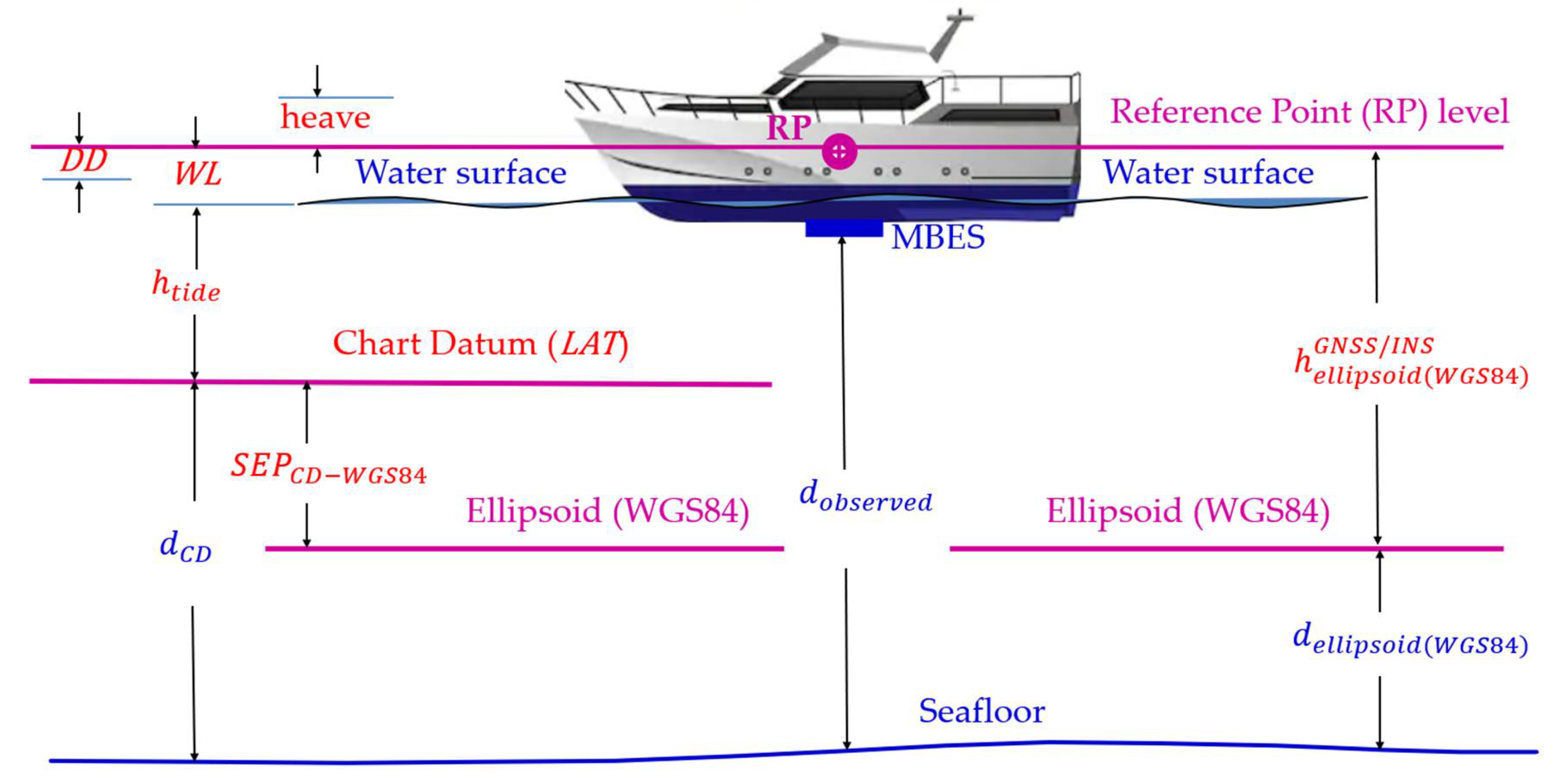
2.1. Separation Model Development Using Multibeam Hydrographic Surveying
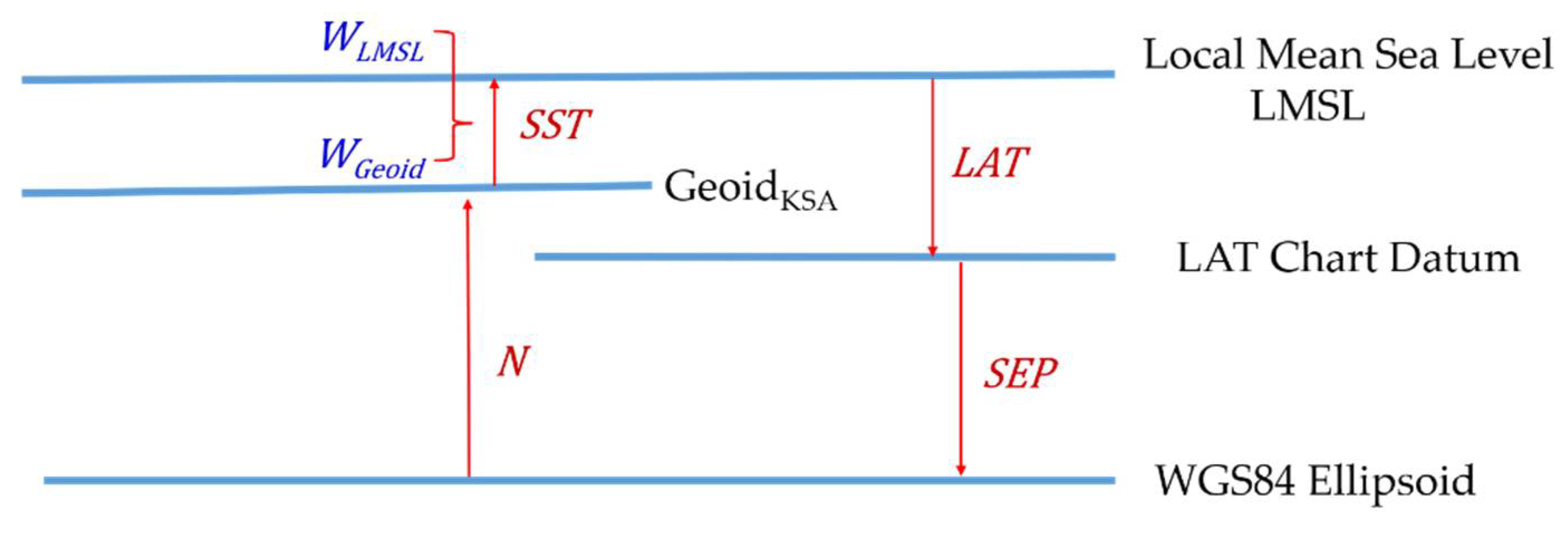
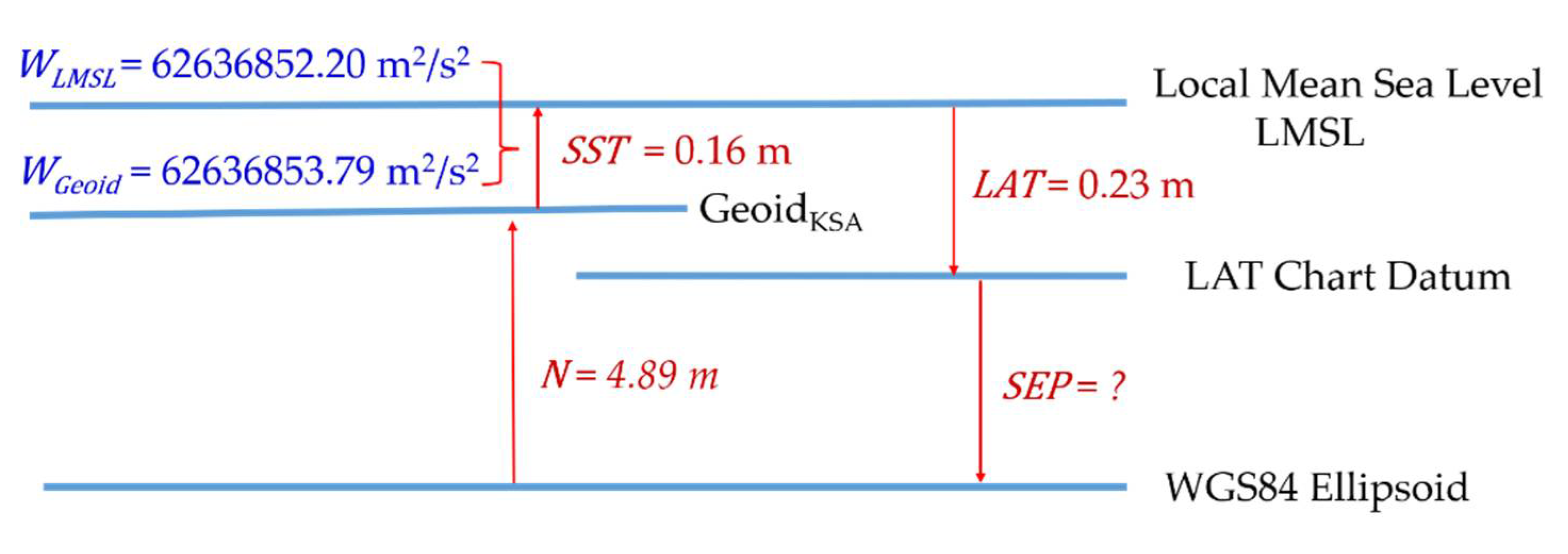
2.2. Separation Model Development Using Gravimetric/Oceanographic Method
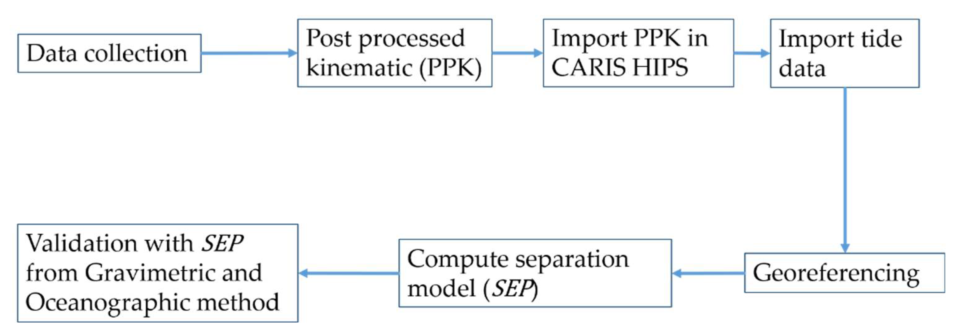
3. Methodology
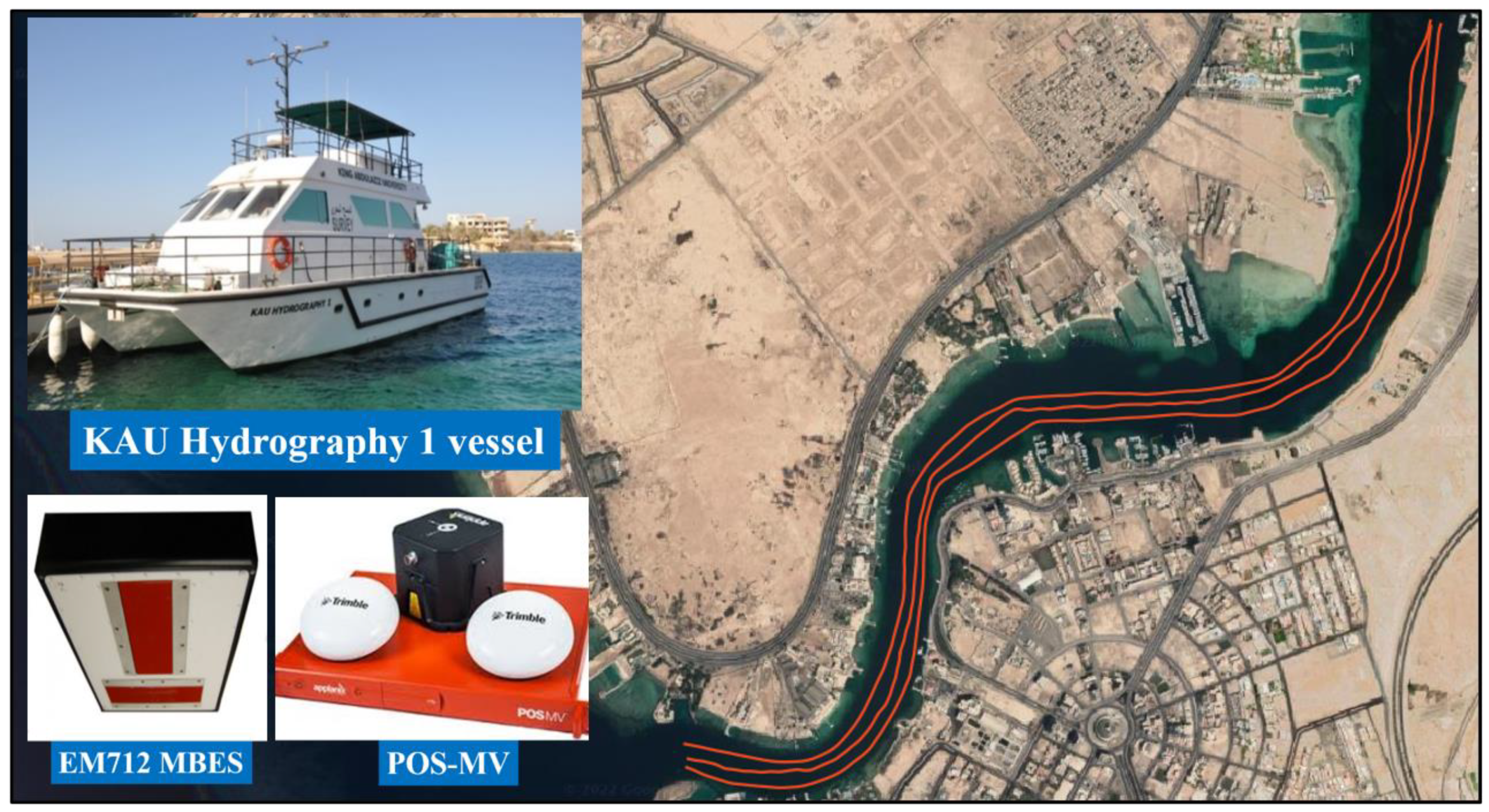
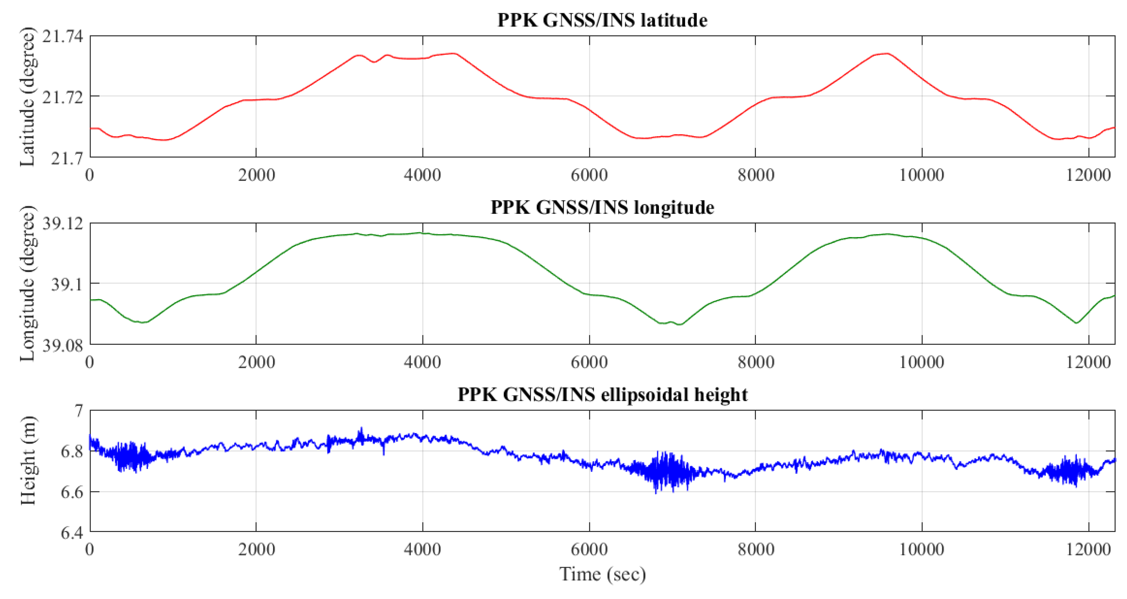
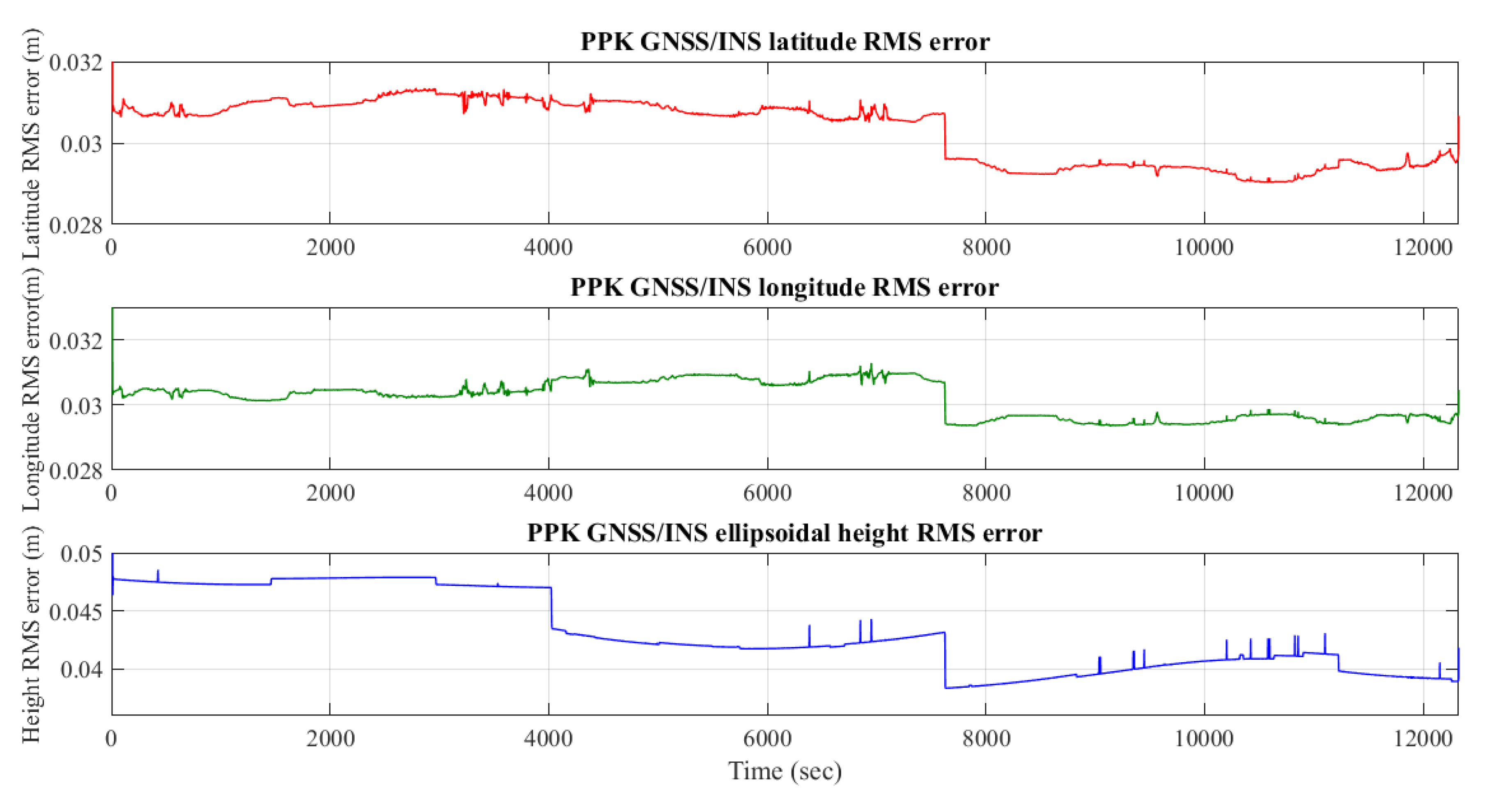
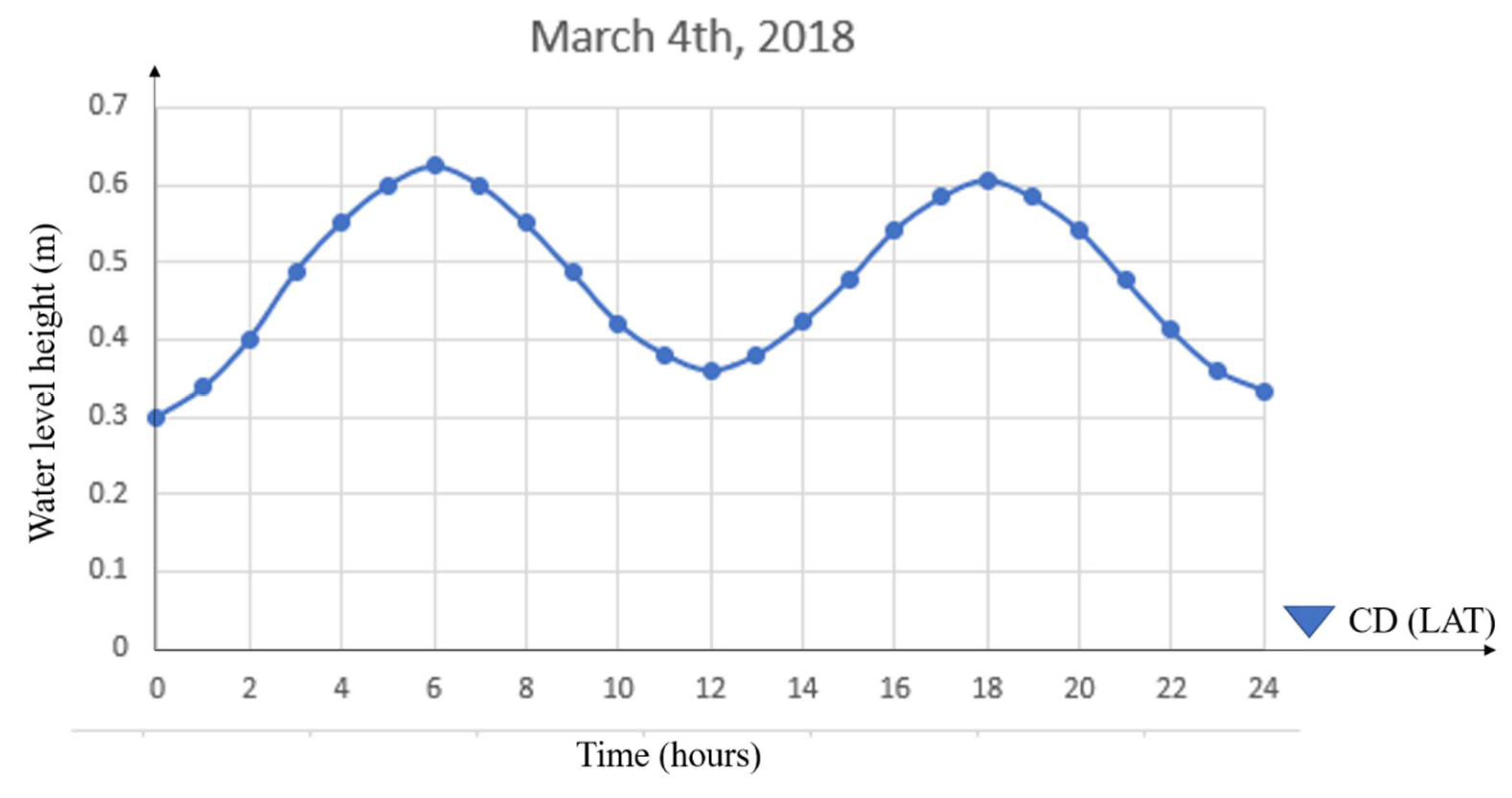
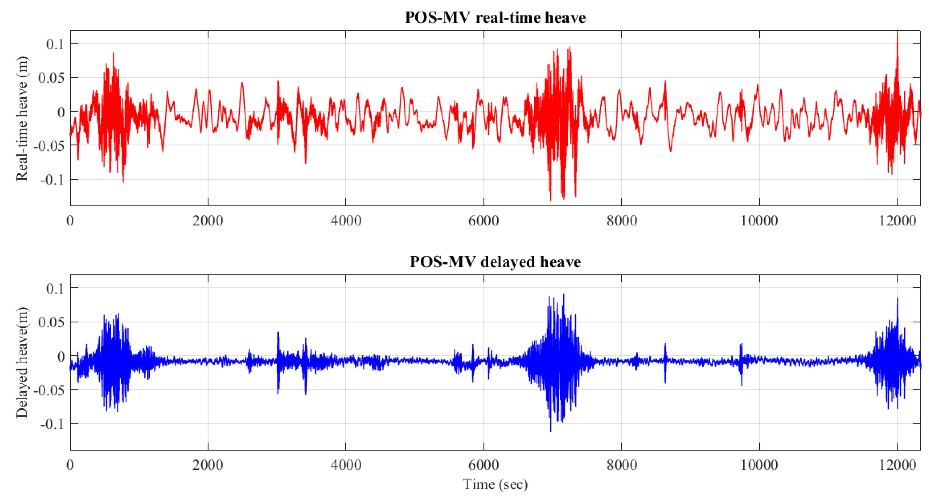
4. Study Area and Data Acquisition
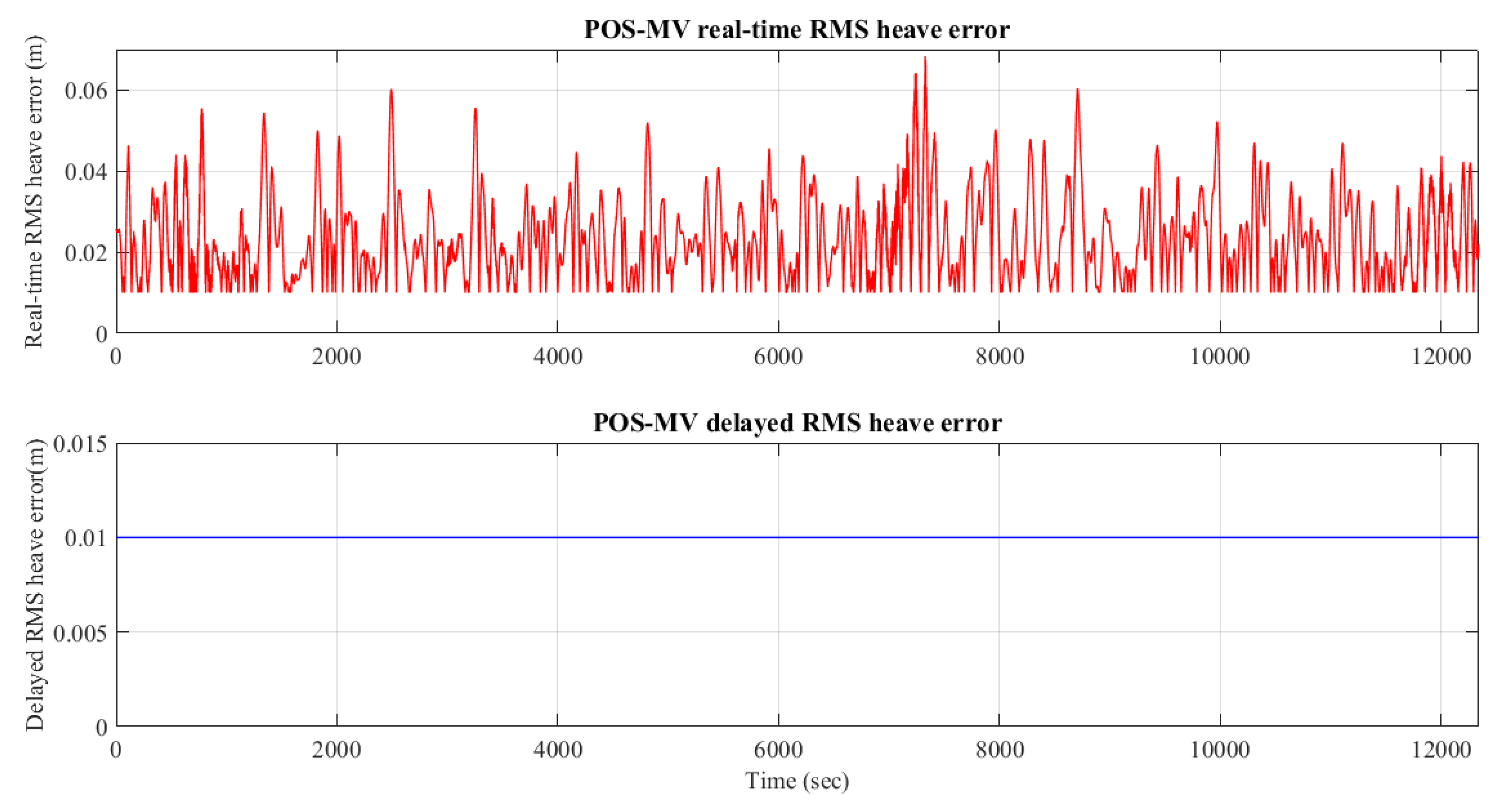
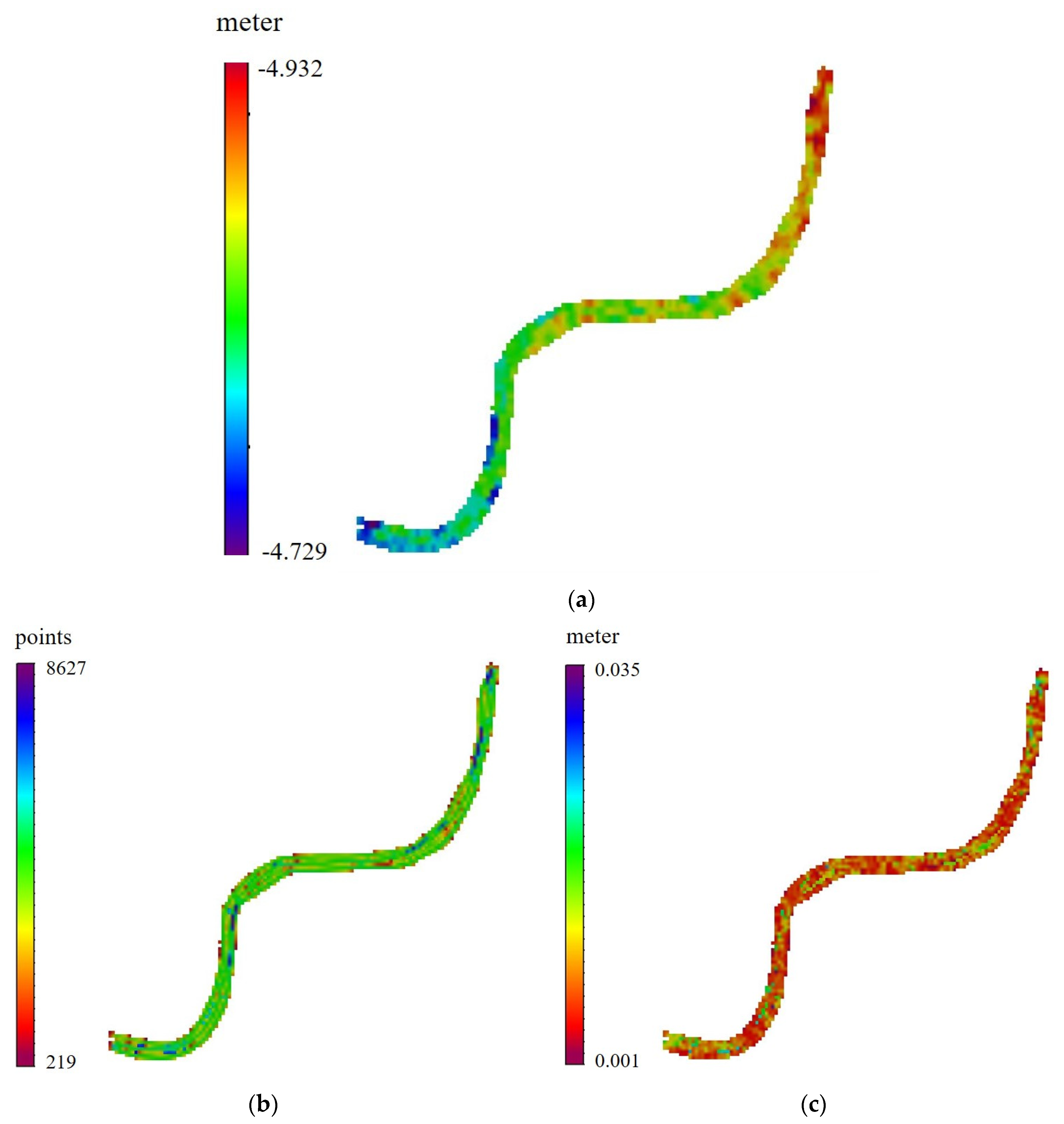
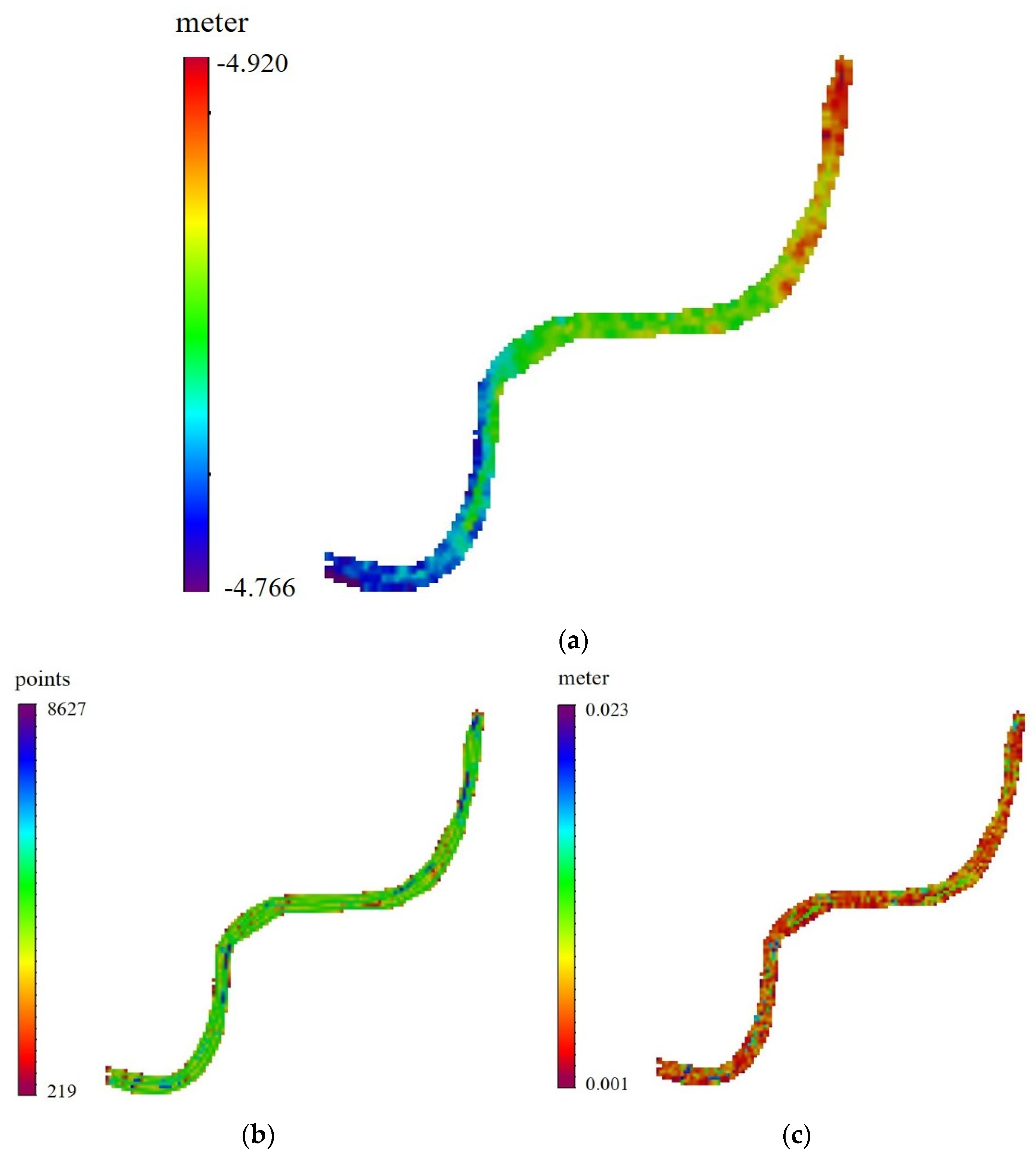
5. Results and Discussion
6. Conclusions
Author Contributions
Funding
Institutional Review Board Statement
Informed Consent Statement
Data Availability Statement
Conflicts of Interest
Appendix A

| Equipment | Data |
|---|---|
| Kongsberg EM712 multibeam echo sounder | Bathymetric measurements |
| POS–MV System | GNSS and inertial unit measurements |
| Valeport’s sound velocity profiler | Sound velocity measurements |
| KSA-CORS GNSS base station MK99 | GNSS measurements |
| Jeddah tide gauge station | ARAMCO tide table data |
References
- Rice, G.; Riley, J. Measuring the Water Level Datum Relative to the Ellipsoid during Hydrographic Survey; NOAA: Washington, DC, USA, 2011. Available online: https://nauticalcharts.noaa.gov/learn/docs/ellipsoidally-referenced-surveys/rice-riley-measuring-water-level-datum-relative-ers.pdf (accessed on 30 November 2021).
- Mills, J.; Dodd, D. Ellipsoidally Referenced Surveying for Hydrography; FIG: Copenhagen, Denmark, 2014; Available online: https://www.fig.net/resources/publications/figpub/pub62/Figpub62.pdf (accessed on 30 November 2021).
- El-Diasty, M.; Al-harbi, S.; Pagiatakis, S. Development of Saudi continuous chart datum: Arabian Gulf case study. Geomat. Nat. Hazards Risk 2019, 10, 1738–1749. [Google Scholar] [CrossRef]
- Abd-Rahman, M.; Din, A. The Development of Continuous Hydrographic Datum Using Geodetic Based Approaches: A Review. IOP Conf. Ser. Earth Environ. Sci. 2020, 540, 012062. [Google Scholar] [CrossRef]
- Kaloop, M.; Pijush, S.; Rabah, M.; Al-Ajami, H.; Hu, J.; Zaki, A. Improving accuracy of local geoid model using machine learning approaches and residuals of GPS/levelling geoid height. Surv. Rev. 2021, 1–14, In press. [Google Scholar] [CrossRef]
- Handa, E. Tidal datums. In Encyclopedia of Coastal Science; Finkl, C., Makowski, C., Eds.; Springer: Berlin/Heidelberg, Germany, 2019. [Google Scholar]
- Iliffe, J.C.; Ziebart, M.K.; Turner, J.F.; Talbot, A.J.; Lessnoff, A.P. Accuracy of vertical datum surfaces in coastal and offshore zones. Surv. Rev. 2013, 45, 254–262. [Google Scholar] [CrossRef]
- IHO. IHO Standards for Hydrographic Surveys. 2020. Available online: https://iho.int/uploads/user/pubs/Drafts/S-44_Edition_6.0.0-Final.pdf (accessed on 18 December 2021).
- Jeffries, M.; Nudds, S.; Robin, C.; MacAulay, P.; Godin, A.; Boom, B.; Dangerfield, N.; Bartlett, J. The Canadian Continuous Vertical Datum for both Land and Sea; CHC-NSC: Victoria, BC, USA, 2018. [Google Scholar]
- Robin, C.; Nudds, S.; MacAulay, P.; Godin, A.; de Lange, B.; Bartlett, J. Hydrographic Vertical Separation Surfaces (HyVSEPs) for the Tidal Waters of Canada. Mar. Geod. 2016, 39, 195–222. [Google Scholar] [CrossRef]
- Robin, C.; Godin, A.; Macaulay, P.; de Lange, B.; Lefaivre, D.; Herron, T.; Sinnott, D.; Ballantyne, A.; Maltais, L.; Veronneau, M. The Canadian hydrographic continuous vertical datum: Methodology and accuracy. In Proceedings of the CHC 2012 Conference Proceedings, Niagara Falls, ON, Canada, 15–17 May 2012. [Google Scholar]
- Robin, C.; Nudds, S.; MacAulay, P.; Godin, A.; Boom, B.; Bartlett, J.; Maltais, L.; Herron, T.; Fadaie, K.; Craymer, M.; et al. The continuous vertical datum for Canadian waters project: Overview & status report. In Proceedings of the Canadian Hydrographic Conference, Toronto, ON, Canada, 14–17 April 2014. [Google Scholar]
- Gesch, D.; Wilson, R. Development of a Seamless Multisource Topographic/Bathymetric Elevation Model for Tampa Bay. Mar. Technol. Soc. J. 2001, 35, 58–64. [Google Scholar] [CrossRef][Green Version]
- Pineau-Guillou, L.; Dorst, L. Creation of vertical reference surfaces at sea using altimetry and GPS. Ann. Hydrogr. 2011, 8, 1–7. [Google Scholar]
- Keysers, J.H.; Quadros, N.D.; Collier, P.A. Developing a Method to Establish a Common Vertical Datum before Integrating Land Height Data with Near-Shore Seafloor Depth Data; Report Prepared for the Commonwealth Government of Australia; Department of Climate Change and Energy Efficiency: Canberra, Australia, 2013. [Google Scholar]
- Slobbe, D.C.; Sumihar, J.; Frederikse, T.; Verlaan, M.; Klees, R.; Zijl, F.; Farahani, H.H.; Broekman, R. A Kalman Filter Approach to Realize the Lowest Astronomical Tide Surface. Mar. Geodesy 2018, 41, 44–67. [Google Scholar] [CrossRef]
- CARIS. CARIS HIPS and SIPS Professional: Version 11.0; Teledyne CARIS, Inc.: Fredericton, NB, Canada, 2018. [Google Scholar]
- Adams, R. The development of a vertical reference surface and model for hydrography—A guide. In Proceedings of the XXIII International FIG Conference, Munich, Germany, 8–13 October 2006. [Google Scholar]
- De Lange, B. Vertical datum separation models for the British Columbia coast. In Proceedings of the CHC 2012 Conference, Niagara Falls, ON, Canada, 1–5 September 2012. [Google Scholar]
- Lefaivre, D.; Dodd, D.; Godin, A.; Herron, T.; MacAulay, P.; Sinnott, D. The continuous vertical datum Canadian waters project (beginnings, vision, methods and progress). In Proceedings of the CHC 2010 Conference, Quebec, QC, Canada, 10–16 February 2010. [Google Scholar]
- Torge, W.; Müller, J. Geodesy, 4th ed.; Walter de Gruyter: Berlin, Germany, 2012. [Google Scholar]
- El-Diasty, M. Development of Real-Time PPP-Based GPS/INS Integration System Using IGS Real-Time Service for Hydrographic Surveys. J. Surv. Eng. 2015, 142, 05015005. [Google Scholar] [CrossRef]
- Shamji, V.R.; Vineesh, T.C. Shallow-water tidal analysis at Sharm Obhur Jeddah, Red Sea. Arab. J. Geosci. 2017, 10, 61. [Google Scholar] [CrossRef]
- Al-Kherayef, O. Geodetic Earth Observations Combination for Vertical Reference System Definition—A Case Study for the Kingdom of Saudi Arabia Vertical Datum and Vertical Reference Frame. Ph.D. Thesis, University of Mining and Geology St Ivan Rilski, Sofia, Bulgaria, 2020. [Google Scholar]


| Parameter\Solution | SEP with Real-Time Heave | SEP with Delayed Heave |
|---|---|---|
| Maximum SEP | −4.729 m | −4.766 m |
| Minimum SEP | −4.932 m | −4.920 m |
| Mean SEP | −4.841 m | −4.841 m |
| Maximum density | 8627 points | 8627 points |
| Minimum density | 219 points | 219 points |
| Mean density | 4055 points | 4055 points |
| Maximum standard deviation | 0.035 m | 0.023 m |
| Minimum standard deviation | 0.001 m | 0.001 m |
| Mean standard deviation | 0.007 m | 0.005 m |
Publisher’s Note: MDPI stays neutral with regard to jurisdictional claims in published maps and institutional affiliations. |
© 2022 by the authors. Licensee MDPI, Basel, Switzerland. This article is an open access article distributed under the terms and conditions of the Creative Commons Attribution (CC BY) license (https://creativecommons.org/licenses/by/4.0/).
Share and Cite
El-Diasty, M.; Kaloop, M.R.; Alsaaq, F. Chart Datum-to-Ellipsoid Separation Model Development for Obhur Creek Using Multibeam Hydrographic Surveying. J. Mar. Sci. Eng. 2022, 10, 264. https://doi.org/10.3390/jmse10020264
El-Diasty M, Kaloop MR, Alsaaq F. Chart Datum-to-Ellipsoid Separation Model Development for Obhur Creek Using Multibeam Hydrographic Surveying. Journal of Marine Science and Engineering. 2022; 10(2):264. https://doi.org/10.3390/jmse10020264
Chicago/Turabian StyleEl-Diasty, Mohammed, Mosbeh R. Kaloop, and Faisal Alsaaq. 2022. "Chart Datum-to-Ellipsoid Separation Model Development for Obhur Creek Using Multibeam Hydrographic Surveying" Journal of Marine Science and Engineering 10, no. 2: 264. https://doi.org/10.3390/jmse10020264
APA StyleEl-Diasty, M., Kaloop, M. R., & Alsaaq, F. (2022). Chart Datum-to-Ellipsoid Separation Model Development for Obhur Creek Using Multibeam Hydrographic Surveying. Journal of Marine Science and Engineering, 10(2), 264. https://doi.org/10.3390/jmse10020264