Article

Acquisition of Crop Spatial Patterns Based on Remote Sensing Data from Sentinel-2 Satellite

1
Key Laboratory of Water and Soil Conservation on the Loess Plateau of MWR, Yellow River Institute of Hydraulic Research, Zhengzhou 450003, China
2
The National Key Laboratory of Water Disaster Prevention, Hohai University, Nanjing 210024, China
3
College of Hydrology and Water Resources, Hohai University, Nanjing 210024, China
4
Yangtze Institute for Conservation and Development, Hohai University, Nanjing 210024, China
*
Author to whom correspondence should be addressed.
These authors contributed equally to this work.
Agriculture 2025, 15(6), 633; https://doi.org/10.3390/agriculture15060633
Submission received: 11 February 2025 / Revised: 8 March 2025 / Accepted: 13 March 2025 / Published: 17 March 2025

Abstract

:
The timely and accurate acquisition of spatial distribution information for crops holds significant scientific significance for crop yield estimation, management, and timely adjustments to crop planting structures. This study revolves around Henan and Shaanxi provinces, employing a spatiotemporal image data fusion approach. Utilizing the characteristic representation of the Normalized difference vegetation index (NDVI) temporal data from Sentinel-2 satellite imagery, a multi-scale segmentation of patches is conducted based on spatiotemporal fusion images. Decision tree classification rules are constructed through the analysis of crop phenological differences, facilitating the extraction of the crop spatial patterns (CSPs) in the two provinces. The classification accuracy is assessed, yielding overall accuracies of 91.11% and 90.12%, with Kappa coefficients of 0.897 and 0.887 for Henan and Shaanxi provinces, respectively. The results indicate the following: (1) the proposed method enhances crop identification capabilities; (2) an accuracy evaluation against the data from the Third National Land Resource Survey and provincial statistical yearbook data for 2022 demonstrates extraction accuracy exceeding 90%; and (3) an analysis of the crop spatial patterns in 2022 reveals that wheat and corn are the predominant crops in Henan and Shaanxi provinces, covering 74.42% and 62.32% of the total crop area, respectively. The research outcomes can serve as a scientific basis for adjusting the crop planting structures in these two provinces.

1. Introduction

The timely and accurate acquisition of spatial distribution information for crops bears paramount scientific significance, impacting crop yield estimation, management, and the prompt adjustment of crop planting structures [1]. As China stands as a populous and major grain-producing nation, the timely detection of crop types and their spatial distribution in agricultural regions becomes particularly crucial [2]. Remote sensing technology facilitates the timely and accurate mapping of regional crop spatial distribution, providing essential foundational data for crop detection, yield estimation, and disaster warnings [3,4]. Leveraging the advantages of remote sensing technology to extract crop information has become a focal point for researchers both domestically and internationally.
The crop spatial pattern (CSP) is a crucial prerequisite for understanding the types of crops, crop planting structures, and the spatial distribution characteristics of crops in a region [5]. Utilizing single optical remote sensing imagery for crop spatial distribution identification is a primary method for crop classification. As early as the 1960s, Purdue University in the United States pioneered the use of remote sensing data for monitoring the cultivation of a single crop, corn, substantiating the feasibility of satellite remote sensing data in agricultural monitoring [6]. In 1970, the United States and the European Union, among other countries, initiated the establishment of agricultural monitoring remote sensing platforms. The United States conducted the “Large Area Crop Inventory Experiment”, utilizing Landsat 1–3 satellites to estimate the spatial distribution of wheat cultivation in certain states [7,8,9,10,11]. With increasing practical demands, the use of optical remote sensing data for crop monitoring expanded from single-crop assessments to monitoring mixed cultivation practices and diverse crop planting structures [12,13]. Brian D. Wardlow et al. evaluated crop classification in the Central United States using Normalized Difference Vegetation Index (NDVI) products based on the Moderate Resolution Imaging Spectroradiometer (MODIS) every eight days, achieving an overall accuracy ranging from 95% for summer crops (such as corn and soybeans) to 84% [14]. Xun et al., capitalizing on MODIS data at 4-day intervals, calculated 11 phenological periods, compared phenological differences among different crops, and extracted planting areas of winter wheat, pure corn, summer corn, cotton, and orchards in the North China Plain from 2003 to 2016 [15]. Ren et al., using MODIS surface reflectance products at 8-day and 16-day intervals, extracted the spatial distribution of winter wheat cultivation in the Huang-Huai-Hai Plain from 2001 to 2016 and estimated crop yields [16].
Along with the advancement of remote sensing satellite platforms and sensors, satellites with high spatial and spectral resolutions, such as Sentinel-2 A/B, the GF series, and VENμS, have provided the possibility to construct high-resolution temporal–spatial datasets for research in small to medium-sized areas, fragmented landscape structures, and precision agriculture [17,18,19,20]. Xia et al., utilizing the temporal data and red-edge band index of GF-6, conducted a fine classification of crops in the complex agricultural landscape of Qianjiang City. When comparing the classification results with Landsat as the data source, the improvements in the temporal, spatial, and spectral resolutions of GF-6 significantly enhanced the classification accuracy compared to Landsat results [21]. Yi et al., based on temporal Sentinel-2 data, classified the six main crops in the Shiyang River Basin. They demonstrated that the shortwave infrared and red-edge bands of Sentinel-2 were most effective in distinguishing crops in the study area. Additionally, the inclusion of July data significantly improved the accuracy of crop classification when juxtaposed with the early stages of crop growth [22].
Continuous remote sensing detection for vegetation poses significant challenges in fragmented or cloudy landscapes [23]. Spatiotemporal fusion methods have emerged as effective, rational, and cost-efficient solutions to address such challenges, experiencing rapid development in recent years [24]. Presently, the primary application of spatiotemporal fusion methods in crop classification involves filling gaps in temporal data by replacing missing or inaccessible images due to cloud cover. This is performed to derive the phenology of various crops in the study area, distinguishing them based on differences in their phenological histories. In previous studies on medium- and large-scale CSPs, there were problems such as the low spatiotemporal resolution of data, significant influence of cloud cover and other factors, and low accuracy of crop species differentiation and extraction results. This study introduces higher spatiotemporal resolution remote sensing images, spatiotemporal fusion, and segmentation before classification research methods to improve the accuracy of medium- and large-scale CSP extraction results to a certain extent, providing new ideas for related research. In this study, Henan and Shaanxi provinces are selected as the research areas. Utilizing spatiotemporal image fusion technology, 10 m spatial resolution Sentinel-2 multi-spectral satellite images are temporally selected and fused. Object-oriented classification and crop type identification are then performed based on the fused images. The aim is to furnish a scientific foundation for adjusting the crop planting structures in the region (Figure 1).

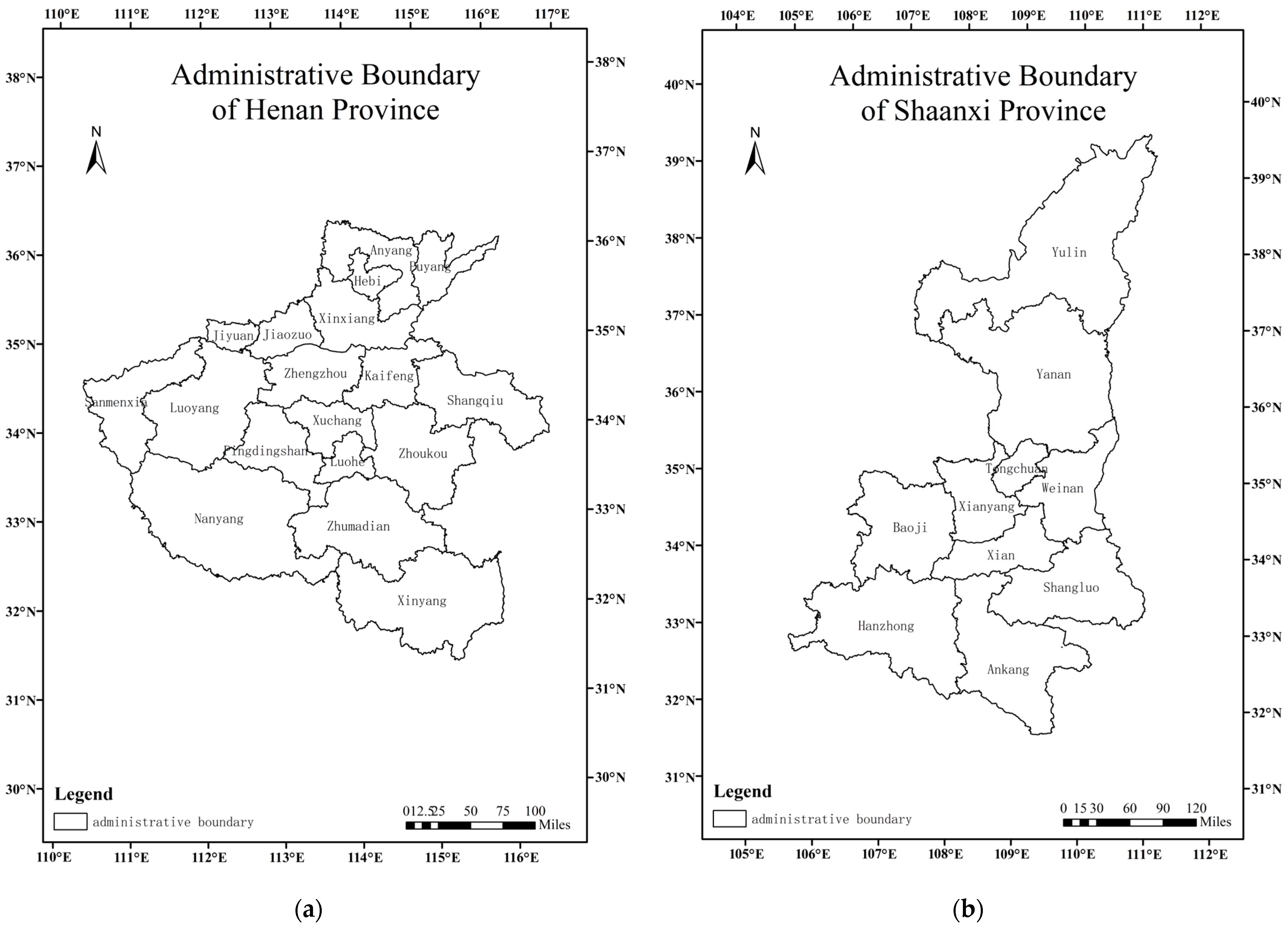
2. Research Area and Data
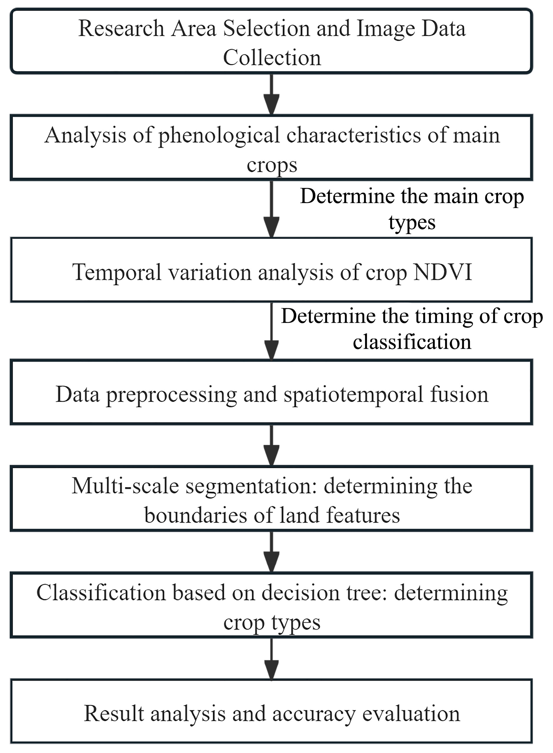
As shown in Figure 2a, Henan Province is situated in the central–eastern part of China, spanning the middle and lower reaches of the Yellow River. The terrain slopes from west to east, bordered on the north, west, and south by the Taihang Mountains, Funiu Mountains, Tongbai Mountains, and Dabie Mountains, forming a semi-circular distribution along the provincial boundary. The central and eastern regions constitute the Yellow-Huai-Hai Plain, while the southwest comprises the Nanyang Basin. The province’s primary economic output is rooted in the primary sector, with a cultivated area of approximately 10,000 hectares, predominantly featuring crops such as wheat, corn, oilseeds, and vegetables.
As shown in Figure 2b, Shaanxi Province is located in the inland northwest, spanning the central regions of the Yellow River and Yangtze River basins. Geographically, it straddles the northern and southern regions due to the Qinling Mountains–Huaihe River line, serving as a vital hub connecting the eastern and central regions of China with the northwest and southwest. The sown area for grain crops in Shaanxi Province is around 3000 hectares, with approximately 1000 hectares dedicated to summer grains and 2000 hectares to autumn grains. The major crops cultivated include corn, wheat, and vegetables.
Sentinel-2 is a high-resolution multi-spectral imaging satellite equipped with a Multi-spectral Instrument (MSI), designed for land monitoring. It provides images of vegetation, soil, water cover, inland waterways, coastal regions, and more. Comprising two satellites, Sentinel-2A and Sentinel-2B, they work in tandem with a revisiting cycle of 10 days for one satellite and a complementary 5-day revisiting cycle for both. The Sentinel-2 satellite covers 13 spectral bands, ranging from visible light and near infrared to shortwave infrared, with varying spatial resolutions, reaching up to 10 m. In the optical data realm, Sentinel-2 data include three bands in the red-edge range, which is highly effective for monitoring vegetation health.
This study leverages multi-spectral Sentinel-2 satellite imagery with a 10 m spatial resolution at multiple time points as the primary data source. The satellite image data have higher spatiotemporal resolution compared to other data, such as MODIS and Landsat. For crops, which have special phenological characteristics, using Sentinel-2 satellite data not only improves the spatial resolution of the results but also ensures that more temporal data participate in fusion and classification, improving the accuracy of the results. The Sentinel data source is the European Space Agency’s Copernicus Data Center, which collected a total of 4538 images of the study area (with a data size exceeding 4TB). The image period covers March–October 2022, and the spatial scope covers all regions of Henan Province and Shandong Province. The data processing level is 2A. It conducts analyses on crop phenological characteristics, spatiotemporal image data fusion, and the extraction of CSPs.
The Third National Land Resource Survey (hereinafter referred to as “third survey”) is led by the Ministry of Natural Resources of China and the data are obtained through remote sensing technology, field surveys, and geographic information systems (GISs), comprehensively reflecting the current status and types of and changes in land use in the country. The data have high accuracy, wide coverage, strong authority, and timeliness. The 2022 Provincial Statistical Yearbook (hereinafter referred to as “statistical yearbook”) data are compiled by the statistical bureaus of each province, covering various information such as population, economy, resources, environment, etc. The data sources include government departments, enterprises and institutions, and sampling surveys. The accuracy and quality vary by province and indicator and overall have high reference value. In this study, data from the third survey, the statistical yearbook, are used as auxiliary and validation data. In order to obtain more accurate crop phenological information and evaluate the spatial accuracy of data, 840 points were selected from two provinces for field investigation, and the crop types obtained from these data were visually interpreted and expanded on the images. The above data are used to evaluate the accuracy of the extracted results.

3. Research Method

3.1. Analysis of Phenological Characteristics of Main Crops

As shown in Supplementary Table S1, the growth cycles of major crops in Henan and Shaanxi provinces exhibit slight variations, influenced by diverse crop types and geographical considerations. Taking the maturation phase of wheat as an illustrative example, it typically transpires in late to mid-May in Henan Province and around mid-June in Shaanxi Province. The pivotal phenological phases for key crops in each province are outlined in Supplementary Table S1 and Table 1, encompassing distinctions in sowing periods, crucial growth phases, maturation periods, and overall durations for each crop. In Henan Province, wheat undergoes the earliest sowing and maturation, while soybeans exhibit the latest in both. Oilseed rape boasts the lengthiest growth period, contrasting with corn, which has the briefest duration. In Shaanxi Province, oilseed rape experiences the earliest sowing and maturation, whereas corn features the latest occurrences. Wheat’s growth span surpasses others in duration, while soybeans have the shortest cycle. These divergences in crop phenological phases serve as the fundamental basis for employing multi-temporal remote sensing in crop extraction processes.

3.2. Temporal Variation Analysis of Crop NDVI

The growth process of crops can be reflected using NDVI temporal data. The satellite bands used for NDVI calculation are the red band (R) and near-infrared band (NIR), and the calculation formula is shown in Formula (1). The data used in this study are the sentinel B02, B03, B04, and B08 bands with a spatial resolution of 10 m, corresponding to the B, G, R, and NIR bands. They are used for NDVI calculation, spatiotemporal data fusion, and multi-scale segmentation, respectively. As shown in Figure 3, to ensure the accuracy and rationality of the extraction results as much as possible, utilizing Sentinel-2 imagery, the NDVI during the crop growth period is calculated for each city. Various crops, such as wheat, corn, rice, oilseed rape, soybeans, as well as greenhouse vegetables and tobacco selected based on field surveys and statistical yearbook data, are included in the analysis. Additionally, typical samples of other land cover types like vegetable greenhouses, forests, grasslands (natural), buildings (including bare land), and water bodies are considered for NDVI temporal variation analysis. To avoid data noise or errors caused by extreme samples, more than 20 typical sample points were selected for the NDVI numerical statistics for each crop group. After removing the extreme values, the arithmetic mean was taken as the main crop NDVI phenological characteristic value for subsequent analysis.
N D V I = ρ N I R ρ R ρ N I R + ρ R
where ρ N I R and ρ R indicate reflectance in the near-infrared and red bands, respectively.
The temporal variations in the NDVI during the crop growth period exhibit distinctive patterns, characterized by prominent peaks across various crop types. Taking Zhengzhou City as an example, for wheat, the NDVI values initiate at a relatively low baseline in February–March and gradually increase. From late March to mid-April, they reach a peak, followed by a substantial decline after early to mid-May. In the case of corn, from late May to early and mid-June, NDVI values are comparatively low. Starting from mid-to-late June, there is a gradual ascent, reaching proximity to the peak from mid-to-late July through early to mid-August. Around mid-August, the values reach their zenith, initiating a decline from late August, followed by a substantial drop in September.
Non-crop types exhibit distinct temporal variations compared to crops. The NDVI values over water bodies consistently register negative values, while those over built-up areas show minimal fluctuations, maintaining around 0.05. Grassland NDVI values gradually rise from May to early and mid-June, along with a slow decrease from August to September, reaching a peak of around 0.6. Forested areas display a similar overall trend to grasslands, with a peak around 0.8.
Examining the temporal variations in various crops in different cities, we select combinations of time-phase images with significant NDVI differences for crop extraction. Instances where NDVI changes exhibit multiple peaks indicate diverse crop rotations. Crop extraction is conducted based on the distinct NDVI feature values in different time intervals. The results are shown in Table 1.

3.3. Data Processing

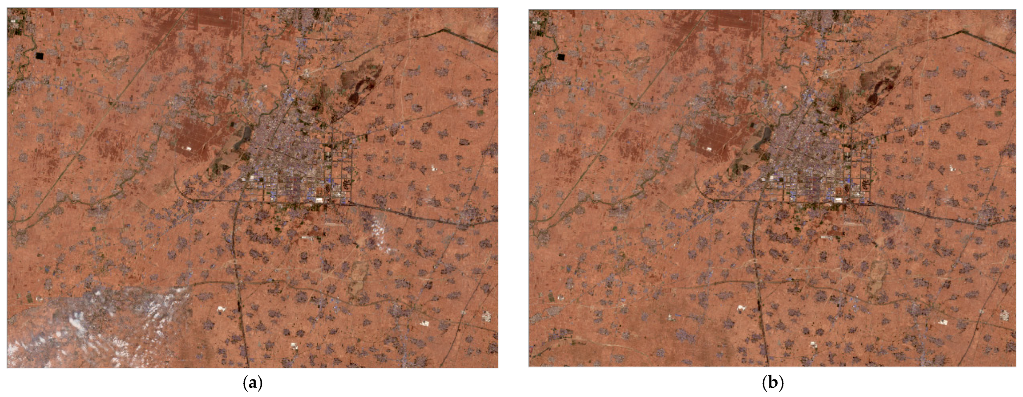
3.3.1. Data Selection and Preprocessing (Including Data Filtering for Significant Crop Distinction Periods, Spatiotemporal Data Mosaicking—Illustrated with a Single Scene)

For the Sentinel-2 images downloaded, the data selection is conducted based on the research requirements. Taking Henan Province as an example, a total of 4538 images for the year 2022 were downloaded, with 1804 images meeting the temporal requirements for various cities. This ensures complete temporal coverage for research data in each city. On a city-by-city basis, the selected data are subjected to band synthesis, resulting in a single-period, single-scene fused image with four bands.

3.3.2. Spatiotemporal Image Fusion

The specific implementation method of spatiotemporal image data fusion in this study is to replace the low-quality areas caused by cloud cover, shadows, and other factors in the target temporal image with adjacent temporal image data, in order to produce a clearer, more easily recognizable, and extracted complete image. The selected image phases in this study are all regions with obvious crop phenological characteristics. To mitigate the impact of clouds on land coverage or the accuracy loss caused by raw data blurring, a method of replacing potentially missing regions in a single-period, single-scene image with data from adjacent temporal periods is employed. This approach eliminates the aforementioned effects, yielding a set of four-band datasets for the research area with enhanced clarity and no obstructions. For example, if the target image is in mid-June, select early June or late June images as supplementary data to replace the occluded parts in the target image. If adjacent temporal images can be used, select the data with a data acquisition time closer to the target image. The results are shown in Figure 4. The spatiotemporal fusion method proposed in this research is mainly aimed at eliminating the impact of image distortion, clouds, shadows, and other factors on recognition accuracy caused by occlusion or ground boundary errors. As the fused images are of similar time and spatial resolution, the fusion technique used is relatively simple. In the areas that need to be repaired, images of similar time are directly replaced, and uniform light and color are used to make the replacement area consistent with the original image effect, achieving the goal of extracting bad areas. In order to minimize the differences caused by time changes, images with consistent or similar time phases are selected as much as possible during fusion, and manual correction after fusion is adopted to ensure the accuracy of the basic data for subsequent research. This study used this method to eliminate clouds and shadows covering all the cultivated land during crop extraction periods in Henan and Shaanxi provinces, with a corrected area of 437.26 km2.

3.4. Extraction of CSPs

Based on multi-scale segmentation, attribute information of segmented objects is utilized to automatically extract category information using a fuzzy logic classification method. This approach effectively overcomes the salt-and-pepper phenomenon arising from pixel-based classification [25].

3.4.1. Multi-Scale Segmentation

In this study, the watershed segmentation algorithm is employed for the segmentation of spatiotemporal fused images, with the following primary segmentation parameter settings: band weights (Image Layer weights) set to 1, shape factor weight (shape) at 0.4, compactness factor weight (compactness) at 0.5, and merge size set to 50. Through multiple experiments and iterative comparisons, the optimal image segmentation scale parameter is determined to be 85. Following segmentation, the cultivated areas of different crops, i.e., field plots, can be extracted. The results are shown in Figure 5.

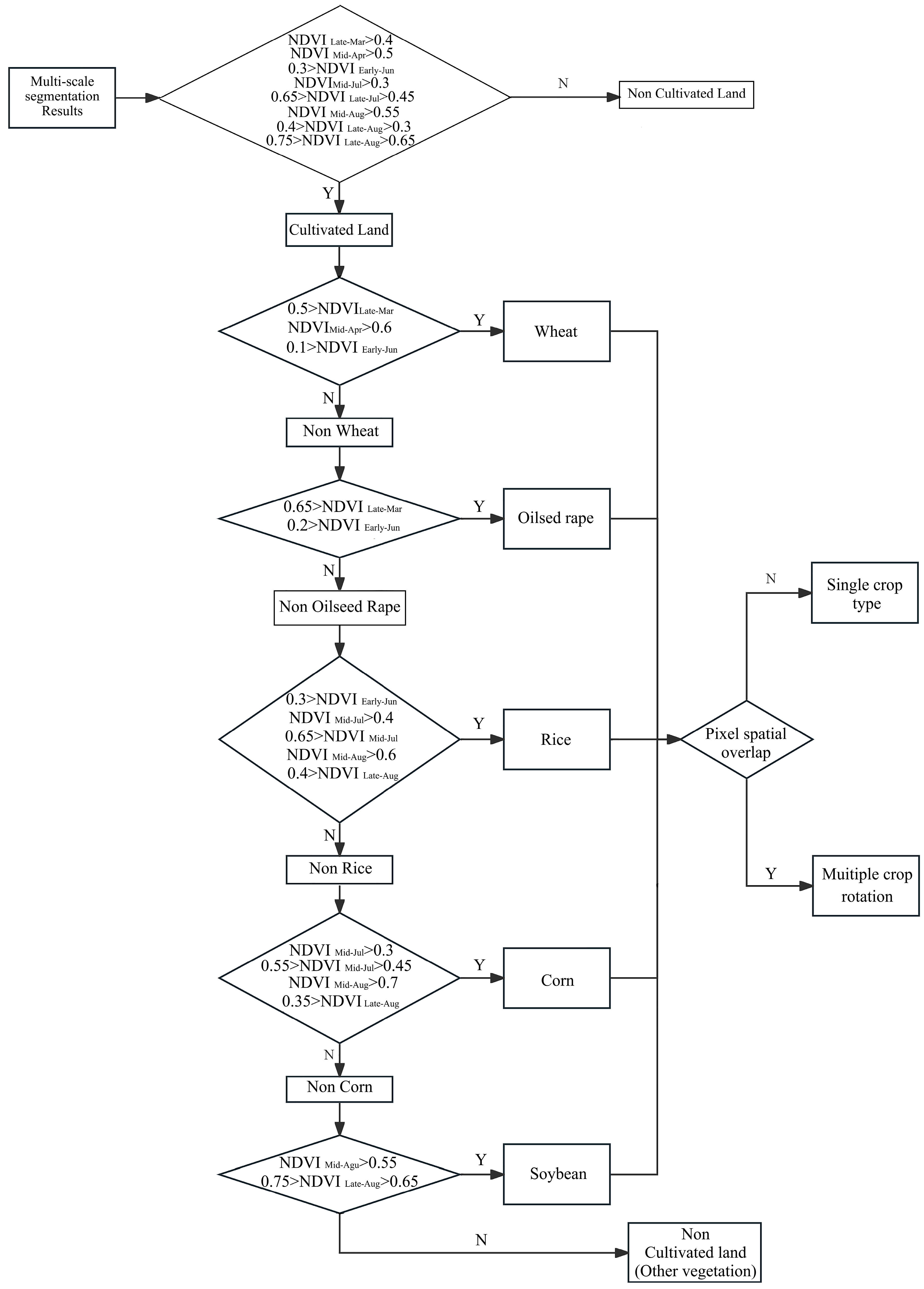
3.4.2. Extraction of Classification Decision Trees

On a municipal level, a classification decision tree is constructed based on the multi-scale segmentation of spatiotemporal fused images and the analysis results of crop NDVI temporal variations. Firstly, by setting thresholds for the NDVI extraction results of each period, cultivated land is differentiated from natural grassland, forest land, water bodies, buildings, and other land types, and cultivated land is extracted. Secondly, based on the extracted mean NDVI values within individual plots and considering the description of dominant crops in various cities from statistical yearbooks, the dominant crops in each city are ranked. Using the NDVI value range and trend during key growth periods for dominant crops, NDVI thresholds are set in the images to sequentially extract each crop type. Finally, areas identified as cultivated land but not yet classified are uniformly designated as unclassified. The decision tree threshold set in this study is based on the critical values of the NDVI differences in the crop phenology. The specific values are learned by comparing the critical values of each crop and obtained through demonstration. Due to the differences in geographical location and climate between Henan Province and Shaanxi Province, the rules and thresholds for crop decision trees vary in different regions. To ensure the accuracy of the extraction results as much as possible, the NDVI phenological difference analysis in this study was conducted on a city by city basis, and the decision tree classification rules and NDVI thresholds for each city were also different. Taking Zhengzhou City as an example, the specific classification rules are shown in Figure 6.

4. Results and Validation

Through the iterative validation and adjustment of the classification extraction results, a comprehensive set of extraction results for various cities is ultimately obtained. The results are shown in Figure 7. To verify the accuracy of the extracted results, validation point data, the third national land survey data, and the statistical yearbook data were used for comparative verification to evaluate the accuracy of the extracted results.

4.1. Accuracy Evaluation

4.1.1. Comparison with Validation Points

Field reconnaissance points are combined with manual visual interpretation of multi-spectral remote sensing images at multiple time points to expand the existing sample points. The time period selected is one where the phenological characteristics of each crop are obvious, and the specific time is up to ten days. After expansion, there are a cumulative of 1597 validation sample points in Henan Province and 2167 in Shaanxi Province. As shown in Figure 8. An accuracy evaluation proceeds based on these sample points, and the results are shown in Supplementary Tables S2 and S3: The overall accuracy in Henan Province is 91.11%, with a Kappa coefficient of 0.897. In the classification results, there are instances of misclassification due to the similarity in the phenological characteristics between some wheatcorn rotation areas and vegetable fields, leading to mixed classification of different crops. The overall accuracy in Shaanxi Province is 90.12%, with a Kappa coefficient of 0.887. Similar to Henan Province, misclassification occurs in some areas due to the similarity in the phenological characteristics between some wheatcorn rotation areas and soybeans, as well as vegetables. Additionally, some misclassification and omission occur due to the relatively fragmented nature of some crop plots, resulting in the ineffective segmentation of some patches.

4.1.2. Comparison with the Third Survey

Conducting a comparative analysis between the data from the extraction results and the third survey from various cities, we assessed the accuracy of this method in extracting the total cultivated land area. The results are shown in Table 2. The outcomes reveal varying accuracy levels in the extraction results across different regions. In Henan Province, the highest accuracy is observed in Nanyang City (95.66%), while the lowest is in Zhengzhou City (90.59%). Similarly, in Shaanxi Province, accuracy peaks in Yulin City (99.84%) and hits a low in Xi’an City (91.74%). Upon closer examination, the broader distribution of mountainous regions in both provinces contributes to higher accuracy, as dominant crops prevail with distinctive phenological features, facilitating differentiation from forested and grassland areas. In contrast, plain areas, particularly those undergoing rapid urbanization, exhibit challenges in distinguishing cultivated zones from leveled government reserves and artificially landscaped areas. This complexity diminishes the accuracy of the extraction process.

4.1.3. Comparison with the Statistical Yearbook for Validation

We conducted a comparative analysis by juxtaposing the extraction results with statistical yearbook data from different cities, aiming to assess the accuracy of this method in extracting crop types and planting areas at the municipal level. The results are shown in Table 3. Through a comprehensive cross-provincial comparison of accuracy across various cities, those situated in hilly regions, such as Sanmenxia and Nanyang in Henan Province, as well as Yulin, Ankang, and Shangluo in Shaanxi Province, exhibited consistently higher accuracy in extracting areas for various crop types compared to cities located in plain areas or undergoing relatively rapid urbanization. This observed phenomenon can be attributed to several factors. Firstly, in hilly regions, the planting locations and timing of crops are relatively stable, making their phenological features more distinct and thus reducing the difficulty in differentiation. In contrast, plain areas experience frequent intercropping, rotation, and multiple cropping, leading to faster land cover changes and less obvious phenological characteristics of crops, thereby increasing the difficulty in crop extraction. Secondly, the distinct differences in shape, spectrum, and other features between crops and other land types in hilly regions contribute to a more accurate delineation of boundaries in the extracted land features. In plain areas, issues such as mixing, misclassification, and omission are more prone to occur. Additionally, discrepancies between data from the statistical yearbook and the third survey in certain cities in Shaanxi Province have introduced significant errors, further impacting the accuracy of extracting specific land cover categories.

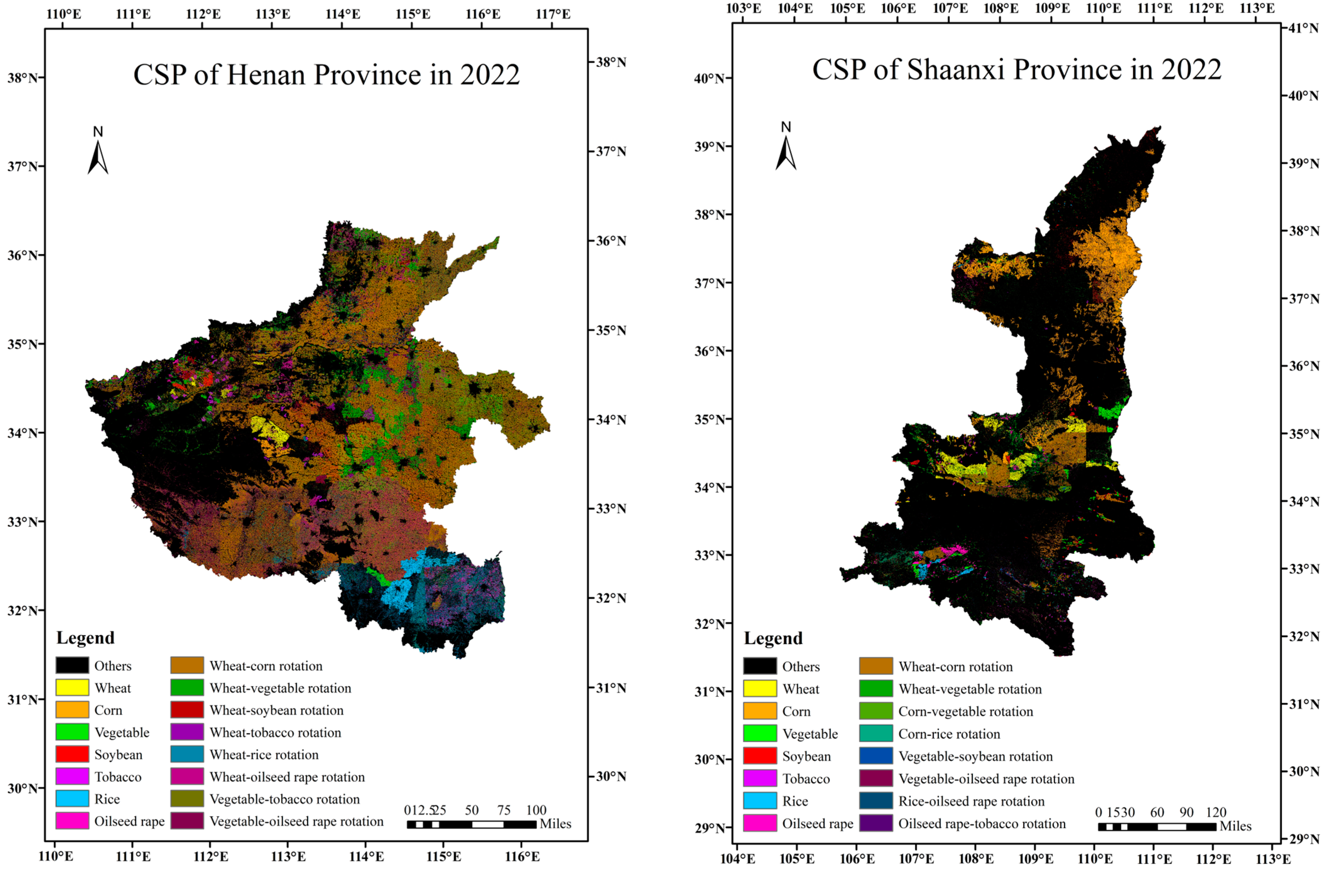
4.2. Analysis of CSP

In accordance with the extracted CSP, the total agricultural area in Henan Province in 2022 is estimated at 77,932.11 km². The proportional distribution of major crops, accounting for overlaps due to crop rotation and intercropping, is as follows: wheat (74.42%), corn (48.79%), vegetables (25.28%), oilseed rape (18.69%), rice (7.61%), soybeans (4.16%), and tobacco (0.99%). Wheat and corn predominantly occupy the central plains, primarily through rotation practices. Vegetables are mainly distributed in the central–eastern and some western mountainous areas. Oilseed rape is concentrated in the central–southern regions, with some areas intercropped or rotated with wheat. Rice cultivation is prevalent in the southern regions, while soybeans and tobacco exhibit scattered distributions in the western mountains and northeastern plains. For Shaanxi Province, the total agricultural area in 2022 is reported as 30,376.74 km². The proportional distribution of major crops, considering overlaps from rotation and intercropping, includes corn (62.32%), wheat (30.75%), vegetables (16.98%), oilseed rape (7.13%), soybeans (4.90%), rice (3.48%), and tobacco (0.75%). Corn predominantly occupies the central–northern regions, often rotating with wheat in the central areas. Oilseed rape and rice are mainly cultivated in the southern regions, occasionally intercropped with other crops. Vegetables, soybeans, and tobacco exhibit scattered distributions across the province.

5. Discussion

This study employed traditional spatiotemporal fusion methods to integrate Sentinel-2 multi-temporal data and conducted feature analysis and extraction of CSPs. However, some problems were also encountered in the research: firstly, the spatial and temporal resolution of the images used in this study is limited, and the recognition and verification of intercropping and other situations are restricted, making it impossible to more accurately distinguish the spatial pattern of crops; secondly, the spatiotemporal fusion method used in this study is relatively simple and cannot be applied to time series with significant cloud cover over a long period of time; and finally, this study directly adopted the crop NDVI difference threshold as the classification rule, without using more geometric or texture features to participate in decision-making. In the current research process of crop extraction, some scholars use crop spatial information reconstruction and spatial model allocation methods to extract regional crop spatial information [26,27,28], while others introduce terrain and other multifactor features, or improve more complex extraction models to study crop spatial patterns [29,30]. These research results provide some inspiration for the future development direction of this study. For upcoming research, optimizations could be implemented in the following aspects:
(1)
The integration of higher spatial resolution satellite imagery, such as the GF series, holds promise for augmenting research outcomes, particularly in overcoming the spatial limitations of Sentinel-2 imagery restricted to 10 m. Additionally, delving into more intricate spatiotemporal fusion models stands as a potential avenue for refining both the spatial and temporal resolution of the underlying data.
(2)
In the realm of classifying and extracting CSPs, the incorporation of supplementary image features, including texture features, is poised to enrich analytical capabilities. Furthermore, the utilization of advanced identification algorithms, such as deep learning convolutional neural networks (CNNs), presents an opportunity for achieving heightened accuracy in classification tasks.
(3)
This study mainly focuses on the identification and classification of phenology in mature crops, but early crop identification and extraction are crucial for agricultural planning. In future research, it may be considered to use images of crop sprouting or jointing stages for more refined classification and extraction in order to grasp the planting range and growth status of crops.

6. Conclusions

This study, focusing on Henan and Shaanxi provinces at the municipal level, analyzed the NDVI temporal variations in various crop types. The selected optimal temporal images were then subjected to spatiotemporal image fusion for the extraction of CSPs. The conclusions are as follows:
(1)
Through an examination of the phenology of major crops in the research area and the temporal characteristics of their Sentinel-2 multi-temporal NDVI data, specific time-phase combinations with distinct crop phenology features were identified. The effective utilization of spatiotemporal image fusion notably augmented the differentiation capabilities among different crops.
(2)
Building upon the outcomes of the fused images, a multi-scale segmentation approach was applied to delineate patches of different crop types. Decision tree classification rules, accounting for crop phenological differences, were formulated to facilitate the extraction of CSPs. The overall classification accuracy in both provinces achieved 91.11% and 90.12%, accompanied by Kappa coefficients of 0.897 and 0.887, respectively.
(3)
At the municipal level, the accuracy evaluation of the extraction results proceeded with the data from the third survey results and the 2022 statistical yearbook for validation. The assessment revealed that the extraction accuracy for both the total area occupied by crops and the area occupied by each type of crop surpassed 90% in the majority of cities.
(4)
In 2022, wheat and corn emerged as the most extensively cultivated crops (including rotation) in both Henan and Shaanxi provinces, collectively constituting 74.42% and 62.32% of the overall crop area, respectively. Conversely, tobacco occupied the smallest planting area, representing merely 0.99% and 0.75% of the total crop area in the respective provinces.
The multi-temporal remote sensing data used in this research provided a method with high accuracy and low operational difficulty for CSP extraction and analysis. The method is based on cities in data processing, segmentation, and classification, and the optimal parameters are obtained through repeated experiments without any reference standards. In the accuracy verification stage, the comparison between the third survey and the statistical yearbook based on area statistics results, as well as the validation points method based on visual interpretation and field validation, were used to evaluate the accuracy of the experimental results. The method has the following improvements compared to pixel-based classification and global land cover classification: Adopting a multi-scale segmentation approach, the optimal segmentation scale is achieved by setting parameters, which maximizes the separation of crops with different features while ensuring the spatial continuity of the field. However, pixel-based classification is prone to spatial fragmentation and land cover mixing. Adopting a decision tree-based classification method, priority is given to extracting cultivated land, and then a series of detailed crop classifications are carried out, greatly improving computational efficiency. At the same time, more detailed thematic classifications are carried out with cultivated land as the focus. Compared with global classification, this method not only improves accuracy but also reduces time costs.
Due to the use of a relatively easy to understand rule in this research to identify and distinguish crop types, its core idea is essentially similar to binary classification, closer to decision trees rather than the classification ideas of Random Forests, Support Vector Machines, or deep learning models. This method has lower difficulty in reproduction and higher interpretability [31,32,33,34]. In this method, the most common reason for misclassification is due to result bias caused by intercropping and interplanting of crops, followed by changes in phenological characteristics of some crops due to differences in terrain and local microclimates within the same city, which is also one of the reasons for misclassification errors.

Supplementary Materials

The following supporting information can be downloaded at: https://www.mdpi.com/article/10.3390/agriculture15060633/s1, Supplementary Table S1: Phenological phases of main crops in two provinces. Supplementary Table S2: Confusion matrix for accuracy validation in Henan Province. Supplementary Table S3: Confusion matrix for accuracy validation in Shaanxi Province.

Author Contributions

Y.W.: Conceptualization, Data curation, Formal analysis, Investigation, Methodology, Project administration, Resources, Software, Supervision, Validation, Visualization, Writing—original draft, Writing—review and editing. K.G.: Conceptualization, Funding acquisition, Writing—original draft. X.K.: Methodology, Validation, Writing—original draft. J.Z.: Resources, Writing—review and editing. B.C.: Investigation. C.Z.: Validation, Writing—review and editing. F.J.: Software, Writing—review and editing. All authors have read and agreed to the published version of the manuscript.

Funding

This research was funded by the Basic R&D Special Fund of the Central Government for Non-profit Research Institutes (Grant No. HKY-JBYW-2023-08), the Excellent Young Talents Project of Yellow River Conservancy Commission (Grant No. HQK-202308), and the R&D Project of YRIHR (No. HKY-YF-2024-03).

Institutional Review Board Statement

Not applicable.

Data Availability Statement

All the data used for this study are included within the manuscript.

Acknowledgments

The authors would like to acknowledge the data centers that provided data for this research and the scholars who were engaged in relevant research.

Conflicts of Interest

All the authors declare there are no conflicts of interest of publishing this manuscript.

References

  1. Tang, H.J. Research progress on remote sensing monitoring of crop spatial pattern. Sci. Agric. Sin. 2010, 43, 2879–2888. [Google Scholar]
  2. Huemmrich, K.F.; Privette, J.L.; Mukelabai, M.; Myneni, R.B.; Knyazikhin, Y. Time-series validation of MODIS land biophysical products in a Kalahari woodland, Africa. Int. J. Remote Sens. 2005, 26, 4381–4398. [Google Scholar] [CrossRef]
  3. Yang, N.; Liu, D.; Feng, Q.; Xiong, Q.; Zhang, L.; Ren, T.; Huang, J. Large-scale Crop Mapping Based on Machine Learning and Parallel Computation with Grids. Remote Sens. 2019, 11, 1500. [Google Scholar] [CrossRef]
  4. See, L.; Fritz, S.; You, L.; Ramankutty, N.; Herrero, M.; Justice, C.; Obersteiner, M. Improved Global Cropland Data as an Essential Ingredient for Food Security. Glob. Food Secur. 2015, 4, 37–45. [Google Scholar] [CrossRef]
  5. Shiyin, C.; Zhiyu, M. Temporal and Spatial Characteristics and Optimization of the Intensive Use of Cultivated Land in Maoming City. J. Resour. Ecol. 2020, 11, 598–605. [Google Scholar] [CrossRef]
  6. Xiao, P.; Qian, P.; Xu, J.; Lu, M. A Bibliometric Analysis of the Application of Remote Sensing in Crop Spatial Patterns: Current Status, Progress and Future Directions. Sustainability 2022, 14, 4104. [Google Scholar] [CrossRef]
  7. Lobell, D.B.; Hicke, J.A.; Asner, G.P.; Field, C.B.; Tucker, C.J.; Los, S.O. Satellite estimates of productivity and light use efficiency in United States agriculture, 1982–1998. Glob. Change Biol. 2010, 8, 722–735. [Google Scholar] [CrossRef]
  8. Hill, J.D.; Strommen, N.D.; Sakamoto, C.M.; Leduc, S.K. LACIE—An Application of Meteorology for United States and Foreign Wheat Assessment. J. Appl. Meteorol. 1980, 19, 22–34. [Google Scholar] [CrossRef]
  9. Verdcourt, B. Remarks on the Classification of the Rubiaceae. Bull. Jard. Bot. L’etat Brux./Bull. Van Den Rijksplantentuin Bruss. 1958, 28, 209–290. [Google Scholar] [CrossRef]
  10. Curran, P.J. Multispectral Remote Sensing of Vegetation Amount. Prog. Phys. Geogr. 1980, 4, 315–341. [Google Scholar] [CrossRef]
  11. Kauth, R.J.; Lambeck, P.F.; Richardson, W.; Thomas, G.S.; Pentland, A.P. Feature extraction applied to agricultural crops as seen by LANDSAT. In Proceedings of the LACIE Symposium: 13–16 August 1979; NASA: Housto, TX, USA, 1979. [Google Scholar]
  12. Guoping, Z.; Jiyuan, L.; Zengxiang, Z. Spatial-temporal Changes of Cropland in China for the Past10Years Based on Remote Sensing. Acta Geogr. Sin. 2003, 58, 323–332. [Google Scholar]
  13. Liu, J.; Liu, M.; Tian, H.; Zhuang, D.; Zhang, Z.; Zhang, W.; Deng, X. Spatial and temporal patterns of China’s cropland during 1990–2000: An analysis based on Landsat TM data. Remote Sens. Environ. 2005, 98, 442–456. [Google Scholar] [CrossRef]
  14. Wardlow, B.D.; Egbert, S.L. Large-area crop mapping using time-series MODIS 250 m NDVI data: An assessment for the US Central Great Plains. Remote Sens. Environ. 2008, 112, 1096–1116. [Google Scholar] [CrossRef]
  15. Xun, L.; Wang, P.; Li, L.; Wang, L.; Kong, Q. Identifying crop planting areas using Fourier-transformed feature of time series MODIS leaf area index and sparse-representation-based classification in the North China Plain. Int. J. Remote Sens. 2019, 40, 2034–2052. [Google Scholar] [CrossRef]
  16. Ren, S.; Guo, B.; Wu, X.; Zhang, L.; Ji, M.; Wang, J. Winter wheat planted area monitoring and yield modeling using MODIS data in the Huang-Huai-Hai Plain, China. Comput. Electron. Agric. 2021, 182, 106049. [Google Scholar] [CrossRef]
  17. Vuolo, F.; Neuwirth, M.; Immitzer, M.; Atzberger, C.; Ng, W.T. How much does multi-temporal Sentinel-2 data improve crop type classification? Int. J. Appl. Earth Obs. Geoinf. 2018, 72, 122–130. [Google Scholar] [CrossRef]
  18. Liao, C.; Wang, J.; Xie, Q.; Baz, A.A.; Huang, X.; Shang, J.; He, Y. Synergistic Use of multi-temporal RADARSAT-2 and VENμS data for crop classification based on 1D convolutional neural network. Remote Sens. 2020, 12, 832. [Google Scholar] [CrossRef]
  19. Qian SO, N.G.; Zhou, Q.B.; Wu, W.B.; Qiong, H.U.; Miao, L.U.; Liu, S.B. Mapping regional cropping patterns by using GF-1 WFV sensor data. J. Integr. Agric. 2017, 16, 337–347. [Google Scholar]
  20. Torbick, N.; Huang, X.; Ziniti, B.; Johnson, D.; Masek, J.; Reba, M. Fusion of moderate resolution earth observations for operational crop type mapping. Remote Sens. 2018, 10, 1058. [Google Scholar] [CrossRef]
  21. Xia, T.; He, Z.; Cai, Z.; Wang, C.; Wang, W.; Wang, J.; Song, Q. Exploring the potential of Chinese GF-6 images for crop mapping in regions with complex agricultural landscapes. Int. J. Appl. Earth Obs. Geoinf. 2022, 107, 102702. [Google Scholar] [CrossRef]
  22. Yi, Z.; Jia, L.; Chen, Q. Crop classification using multi-temporal Sentinel-2 data in the Shiyang River Basin of China. Remote Sens. 2020, 12, 4052. [Google Scholar] [CrossRef]
  23. Knauer, K.; Gessner, U.; Dech, S.; Kuenzer, C. Remote sensing of vegetation dynamics in West Africa. Int. J. Remote Sens. 2014, 35, 6357–6396. [Google Scholar] [CrossRef]
  24. Zhu, X.; Zhan, W.; Zhou, J.; Chen, X.; Liang, Z.; Xu, S.; Chen, J. A novel framework to assess all-round performances of spatiotemporal fusion models. Remote Sens. Environ. 2022, 274, 113002. [Google Scholar] [CrossRef]
  25. Qian, Q.J.; Xie, R.; Zhang, L.; Yan, C.Z. Research on Object-Oriented Land Cover Information Extraction Method. Remote Sens. Technol. Appl. 2005, 20, 338–342. [Google Scholar]
  26. Li, H.L.; Dai, S.P.; Hu, Y.Y.; Zhu, P.J.; Li, M.F.; Zheng, Q.; Luo, H.X.; Yu, X. Progress and Development of Crop Spatial Pattern Research. J. Trop. Crops 2023, 44, 2537–2545. [Google Scholar]
  27. Tang, C.G. The role of remote sensing technology in monitoring the spatial pattern of crops. Sci. Technol. Inf. 2021, 19, 79–81. [Google Scholar]
  28. Li, J.R. Research progress on remote sensing monitoring of crop spatial pattern. Rural. Pract. Technol. 2020, 4, 56. [Google Scholar]
  29. Ye, Q.; Yang, F.H.; Liu, H.J.; Meng, X.T.; Guan, H.X.; Cui, Y. Remote sensing yield estimation and spatial pattern analysis of maize at the field scale using terrain features. Sci. Technol. Eng. 2021, 21, 10215–10221. [Google Scholar]
  30. Wang, S.Y.; Liu, J.S.; Ma, T.B. Dynamics and changes in spatial patterns of land use in Yellow River Basin, China. Land Use Policy 2010, 27, 313–323. [Google Scholar] [CrossRef]
  31. Li, X.; Xu, X.; Wang, J.; Wu, H.; Jing, X.; Li, C.; Bao, Y. Crop classification recognition based on time-series images from HJ satellite. Trans. Chin. Soc. Agric. Eng. 2013, 29, 2013. [Google Scholar]
  32. Lei, L. Study on crops classification based on multi-spectral image and decision tree method. J. Anhui Agric. Sci. 2011, 179, 1703–1706+1710. [Google Scholar]
  33. Dong, S.W.; Sun, D.F.; Li, H. Crop Decision Tree Classification Extraction Based on MODIS NDVI in Beijing. Adv. Mater. Res. 2014, 955, 787–790. [Google Scholar] [CrossRef]
  34. Zhang, H.; Wang, Z.; Li, Z.; Liu, X.; Wang, K.; Sun, S.; Gao, Z. Extracting the winter wheat using the decision tree based on time series dual-polarization SAR feature and NDVI. PLoS ONE 2024, 19, e0302882. [Google Scholar] [CrossRef] [PubMed]
Figure 1. Research methodology framework.
Agriculture 15 00633 g001
Figure 2. Range of research areas. (a) Henan Province. (b) Shaanxi Province.
Agriculture 15 00633 g002
Figure 3. Temporal variation in NDVI for main crops (taking Zhengzhou City in Henan Province as an example).
Agriculture 15 00633 g003
Figure 4. Example of the research area satellite imagery after spatiotemporal image data fusion processing (taking the image of Kaifeng City in Henan Province as an example). (a) Before processing. (b) After processing.
Agriculture 15 00633 g004
Figure 5. Example of segmentation results by spatiotemporal image fusion.
Agriculture 15 00633 g005
Figure 6. Schematic of decision tree classification rules in the research area (taking Zhengzhou City in Henan Province as an example).
Agriculture 15 00633 g006
Figure 7. CSP extraction results of spatiotemporal fused images in two provinces.
Agriculture 15 00633 g007
Figure 8. Verification data space distribution diagram. (a) Henan Province. (b) Shaanxi Province.
Agriculture 15 00633 g008
Table 1. Time-phase selection of crop extraction of various cities in the two provinces.
ProvinceCityTime Phase
HenanZhengzhouEarly April, Early June, Early July, Late July, Mid-August
KaifengLate March, Early April, Mid-June, Early July, Late July
LuoyangMid-March, Late April, Early May, Late May, Mid-July
HenanPingdingshanEarly April, Early June, Mid-June, Mid-August
AnyangLate March, Early June, Late July, Early September
HebiLate May, Mid-June, Late July, Early September
XinxiangEarly May, Late May, Mid-June, Late July, Early August, Early September
JiaozuoEarly April, Early May, Mid-May
PuyangLate March, Mid-April, Mid-June, Early July, Mid-September
XuchangEarly May, Early June, Early August
LuoheEarly June, Late July, Early October
SanmenxiaMid-April, Early May, Late June, Late September
NanyangMid-May, Mid-June, Mid-July, Early September, Late September
ShangqiuLate May, Early June, Early July, Mid-August
XinyangMid-March, Late May, Late June, Early August, Early September, Mid-September
ZhoukouMid-April, Mid-May, Mid-June, Late July, Early September
ZhumadianMid-May, Early June, Late July, Mid-August
JiyuanLate March, Early April, Early July, Late July
ShaanxiXi’anEarly March, Early August, Early September
TongchuanMid-March, Late April, Early August
BaojiEarly March, Early April, Late May, Early August
XianyangEarly April, Early August, Mid-August
WeinanMid-March, Late April, Mid-May, Early August
Yan’anEarly March, Mid-June, Mid-September
HanzhongEarly March, Late April, Early July, Mid-August
YulinLate June, Early July, Mid-July, Early August, Mid-September
AnkangMid-April, Late April, Mid-October
ShangluoMid-March, Early April, Late May, Late July, Mid-September
Table 2. The comparison and accuracy assessment of the extraction results with the third survey across various cities in two provinces.
ProvinceCityCultivated Land Area from the Third Survey (km2)Cultivated Land Area from the Extraction Results (km2)Accuracy (%)
Henan ProvinceZhengzhou20682262.5490.59
Kaifeng39964323.3791.81
Luoyang34473520.2597.88
Pingdingshan31363295.3194.92
Anyang37923946.3395.93
Hebi11331035.8991.43
Xinxiang45584713.3996.59
Jiaozuo18201858.8897.86
Puyang25292705.6393.02
Xuchang26812768.7596.73
Luohe18271991.0791.02
Sanmenxia14471405.8497.16
Nanyang987410,006.3598.66
Shangqiu70107548.2392.32
Xinyang79467568.5995.25
Zhoukou84288863.2094.84
Zhumadian93299800.9094.94
Jiyuan329317.6096.54
Shaanxi ProvinceXi’an14121528.6491.74
Tongchuan879878.1299.90
Baoji27252753.7798.94
Xianyang32883290.9499.91
Weinan39904009.0299.52
Yan’an26152652.3498.57
Hanzhong25842720.8594.70
Yulin94859500.2599.84
Ankang17731856.4595.29
Shangluo11431186.3596.21
Table 3. The comparison and accuracy assessment of the extraction results with the statistical yearbook across various cities in two provinces.
ProvinceCityStatistical ResultsCrop Type
WheatRiceCornOilseed RapeVegetablesSoybeanTobacco
Henan ProvinceZhengzhouStatistical yearbook (km2)1360.901.701278.70298.70605.6033.100.20
Extraction results (km2)1357.34-1279.45298.72606.4733.49-
Accuracy (%)99.74-99.9499.9999.8698.83-
KaifengStatistical yearbook (km2)3026.7052.701876.701085.302285.10116.30-
Extraction results (km2)2850.5353.031877.641048.482084.28115.72-
Accuracy (%)94.1899.3899.9596.6791.2199.54-
LuoyangStatistical yearbook (km2)2320.7012.401965.50382.40743.60144.10181.60
Extraction results (km2)2469.5012.661968.23380.62728.06139.44183.24
Accuracy (%)93.5997.9499.8699.5397.9196.7799.94
PingdingshanStatistical yearbook (km2)2205.7010.901973.60439.50532.00127.1096.10
Extraction results (km2)2407.7111.211852.86411.41539.25127.9096.89
Accuracy (%)9.8497.1493.8893.6898.6499.3799.18
AnyangStatistical yearbook (km2)2906.300.102515.60507.301003.7035.20-
Extraction results (km2)2989.17-2516.40518.151063.1232.67-
Accuracy (%)97.15-99.9797.8694.8392.82-
HebiStatistical yearbook (km2)900.70-782.10133.90112.601.40-
Extraction results (km2)924.52-790.63133.89111.37--
Accuracy (%)97.36-98.99100.0098.93--
XinxiangStatistical yearbook (km2)3877.6086.703092.70774.60683.3092.30-
Extraction results (km2)4051.6387.373105.69765.13661.7693.44-
Accuracy (%)95.5199.2399.5898.7896.8598.76-
JiaozuoStatistical yearbook (km2)1500.107.101263.90251.40339.3019.60-
Extraction results (km2)1528.547.231264.88252.86330.3420.42-
Accuracy (%)98.1598.1399.9299.4297.3695.84-
PuyangStatistical yearbook (km2)2316.00175.701532.70204.00619.40226.20-
Extraction results (km2)2190.24174.311534.04204.68619.02226.43-
Accuracy (%)94.5899.2199.9199.6799.9499.90-
XuchangStatistical yearbook (km2)2304.90-1535.90210.00449.60415.5096.60
Extraction results (km2)2436.01-1540.73203.25412.65415.52106.58
Accuracy (%)94.31-99.6996.7891.7899.9989.67
LuoheStatistical yearbook (km2)1472.50-928.80159.60749.90295.8035.40
Extraction results (km2)1590.77-941.43158.46702.36295.3934.73
Accuracy (%)91.97-98.6599.2893.6699.8698.98
SanmenxiaStatistical yearbook (km2)751.70-602.7092.20362.40146.70162.30
Extraction results (km2)800.91-603.1088.64354.70147.11161.59
Accuracy (%)93.45-99.9396.1397.8799.7299.56
NanyangStatistical yearbook (km2)7283.70328.504678.603520.802762.40272.50131.30
Extraction results (km2)7311.84328.884678.623392.282694.51273.81131.42
Accuracy (%)99.6199.88100.0096.3597.5499.5299.97
ShangqiuStatistical yearbook (km2)6055.80-4457.10796.902787.20349.803.00
Extraction results (km2)5995.50-4257.78804.192692.05348.41-
Accuracy (%)99.42-95.5399.8596.5999.64-
XinyangStatistical yearbook (km2)3128.005000.00156.201644.301593.2036.103.40
Extraction results (km2)3196.824981.29156.651642.081592.9535.37-
Accuracy (%)97.8099.6399.7199.8699.9897.98-
ZhoukouStatistical yearbook (km2)7346.101.405428.20944.403306.30736.508.40
Extraction results (km2)7287.92-4999.24877.523021.65680.118.01
Accuracy (%)99.28-92.9892.9291.4092.3495.39
ZhumadianStatistical yearbook (km2)7931.60275.404388.303375.901427.90243.6040.80
Extraction results (km2)8371.79274.094439.093378.521429.11244.7740.87
Accuracy (%)94.4599.5298.8499.9299.9299.5299.84
JiyuanStatistical yearbook (km2)218.200.40200.507.1051.3013.104.90
Extraction results (km2)236.85-218.477.3554.9113.145.34
Accuracy (%)91.45-91.3796.4392.9699.709.95
Shaanxi ProvinceXi’anStatistical yearbook (km2)1402.351.671107.9736.30710.6028.93-
Extraction results (km2)1312.71-1169.0735.55510.4029.54-
Accuracy (%)93.68-94.4897.9371.8397.90-
TongchuanStatistical yearbook (km2)218.240.28431.8616.0028.7013.89-
Extraction results (km2)278.61-540.0016.5528.7314.24-
Accuracy (%)72.34-74.9696.5599.9897.48-
BaojiStatistical yearbook (km2)1861.280.98968.3767.10464.8079.8127.10
Extraction results (km2)1862.20-970.5067.22464.4980.1927.27
Accuracy (%)99.96-99.7899.8399.9399.5299.37
XianyangStatistical yearbook (km2)1961.37-1373.12142.40791.9038.506.10
Extraction results (km2)1992.26-1464.80143.64789.6539.026.11
Accuracy (%)98.43-93.3299.1499.7298.6599.91
WeinanStatistical yearbook (km2)2848.15-2177.74199.10911.7044.18-
Extraction results (km2)2847.22-2177.23204.10913.0544.65-
Accuracy (%)99.97-99.9897.4999.8598.95-
Yan’anStatistical yearbook (km2)2.9612.22750.2216.20252.90150.2610.70
Extraction results (km2)3.8912.362204.2016.10254.80149.7211.27
Accuracy (%)68.5398.87-93.8799.3899.2599.6494.70
HanzhongStatistical yearbook (km2)385.08812.60682.60786.60676.90170.6335.90
Extraction results (km2)386.07812.24683.14785.01675.38170.1735.75
Accuracy (%)99.7499.9699.9299.8099.7799.7399.59
YulinStatistical yearbook (km2)2.9528.802902.17160.40465.70638.510.60
Extraction results (km2)3.0029.698208.22160.45466.10632.79-
Accuracy (%)98.2596.92-82.8399.9799.9199.14-
AnkangStatistical yearbook (km2)291.03201.03824.83648.10835.30142.8676.80
Extraction results (km2)291.77200.39825.78645.26835.45143.3876.91
Accuracy (%)99.7599.6899.8899.5699.9899.6499.86
ShangluoStatistical yearbook (km2)359.831.78687.1591.20218.20185.7669.00
Extraction results (km2)362.021.86689.3492.20218.83185.9970.25
Accuracy (%)99.4095.6399.6998.9499.7199.8898.19
Disclaimer/Publisher’s Note: The statements, opinions and data contained in all publications are solely those of the individual author(s) and contributor(s) and not of MDPI and/or the editor(s). MDPI and/or the editor(s) disclaim responsibility for any injury to people or property resulting from any ideas, methods, instructions or products referred to in the content.

