A Study on Digital Soil Mapping Based on Multi-Attention Convolutional Neural Networks: A Case Study in Heilongjiang Province
Abstract
1. Introduction
2. Materials and Methods
2.1. Description of the Study Area
2.2. Data Collection and Preprocessing
2.2.1. Soil Sample Data
2.2.2. Environmental Covariate Data
2.2.3. Dataset Preprocessing
2.3. Digital Soil Mapping Methodologies and Model Implementation
2.3.1. Feature Selection
2.3.2. MACNN Algorithm
Hierarchical Convolutional Feature Extraction
Multi-Attention Mechanism-Based Feature Enhancement
Cross-Entropy Loss Function
2.3.3. Evaluation Metrics
2.3.4. Parameter Settings
3. Results Analysis
3.1. Comparison of Soil Type Classification Results
3.2. Ablation Study
3.3. Prediction Results
4. Discussion
4.1. Advantages of the MACNN Algorithm
4.2. Discussion of Classification and Ablation Experiment Results
4.3. Limitations of the MACNN Algorithm
5. Conclusions
- (1)
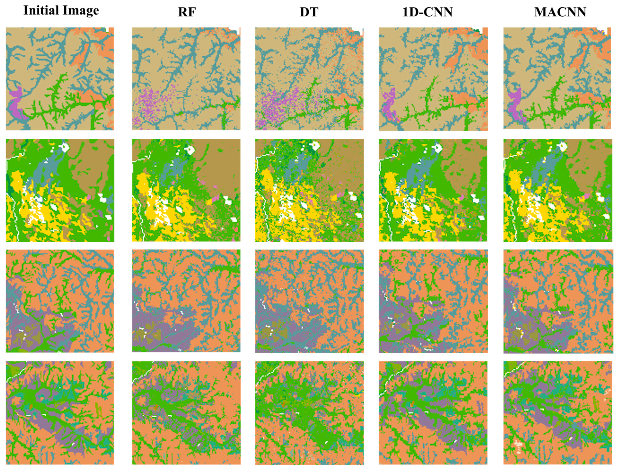
- A comparative analysis of the classification results of the MACNN algorithm against RF, DT, and 1D-CNN, based on classification accuracy evaluation metrics, was conducted. The results indicate that the MACNN algorithm achieved a substantial improvement in overall classification accuracy. Specifically, MACNN attained an overall classification accuracy of 81.27%, which represents an increase of 7.65%, 13.51%, and 5.20% over the RF, DT, and 1D-CNN algorithms, respectively. Furthermore, its Kappa coefficient of 0.7681 showed respective increases of 0.0917, 0.1598, and 0.0685 compared to RF, DT, and 1D-CNN, thus demonstrating higher classification accuracy and a better ability to represent the spatial distribution of soil types.
- (2)
- Ablation study results indicate that integrating Transformer and CBAM modules progressively into the 1D-CNN baseline algorithm led to a notable improvement in classification performance, exhibiting a significant synergistic gain effect. Notably, the maximum performance increase was achieved when both Transformer and CBAM were integrated simultaneously. This robustly validates that the proposed MACNN algorithm is both reliable and effective.
- (3)
- By synergistically combining various attention mechanisms, the MACNN algorithm adaptively focuses on crucial features. This significantly boosts its recognition accuracy for complex soil characteristics. In the visualization of soil type distribution, the model effectively reduces both commission and omission errors, leading to the generation of digital soil type maps with more accurate boundaries and richer details. This algorithm effectively overcomes the limitations in handling spatial heterogeneity and long-range dependencies, thereby offering new technical support for digital soil mapping.
Author Contributions
Funding
Data Availability Statement
Conflicts of Interest
Appendix A. Soil Sample Data
Data Description
| Soil Type | Sample Size |
|---|---|
| Dark-brown earths | 10,000 |
| Albic soils | 2000 |
| Meadow soils | 8600 |
| Meadow solonchaks | 50 |
| Skeletol soils | 60 |
| Aeolian sandy soils | 310 |
| Chernozems | 1550 |
| Black soils | 3000 |
| Dark felty soils | 10 |
| Grey-cinnamon soils | 10 |
| Volcanic soils | 100 |
| Solonetz | 50 |
| Castanozems | 20 |
| Peat soils | 200 |
| Litho soils | 60 |
| Paddy soils | 300 |
| Alluvial soils | 200 |
| Bog soils | 3900 |
| Brown coniferous forest soils | 2500 |
Appendix B. Environmental Covariate Data
Appendix B.1. Study Period
Appendix B.2. Data Description
| Environmental Covariate | Data Sources | Resolution (m) | Year | Definitions |
|---|---|---|---|---|
| Lithology | Geological Map Sharing Database of the China Geological Survey | 30 | 2015 | |
| DEM | NASA’s Land Processes DAAC SRTMGL1v003 | 30 | 2015 | |
| Slope | Calculated from DEM | 30 | 2015 | |
| Aspect | Calculated from DEM | 30 | 2015 | |
| Profile Curvature | Calculated from DEM | 30 | 2015 | |
| Plan Curvature | Calculated from DEM | 30 | 2015 | |
| TWI | Calculated from DEM | 30 | 2015 | |
| NDVI | Sentinel-2 satellite data | 10 | 2015 | |
| Land Use | Geographical Monitoring Cloud Platform | 30 | 2015 | |
| Texture | National Earth System Science Data Center | 30 | 2015 | |
| Temperature | Resource and Environmental Science Data Registration and Publishing System | 1000 | 2015 | |
| Precipitation | National Earth System Science Data Center | 1000 | 2015 |
Appendix B.3. Rationale for the Selection
Appendix C. Algorithm Description
Appendix C.1. RF
Appendix C.2. DT
Appendix C.3. 1D-CNN
Appendix C.4. MACNN
References
- Liang, A.Z.; Zhang, Y.; Chen, X.W.; Zhang, S.X.; Huang, D.D.; Yang, X.M.; Zhang, X.P.; Li, X.J.; Tian, C.J.; Mclaughlin, N.B.; et al. Development and Effects of Conservation Tillage in the Black Soil Region of Northeast China. Sci. Geogr. Sin. 2022, 42, 1325–1335. [Google Scholar]
- McKenzie, N.J.; Ryanb, P.J. Spatial prediction of soil properties using environmental correlation. Geoderma 1999, 89, 67–94. [Google Scholar] [CrossRef]
- Zhu, A.X.; Yang, L.; Fan, N.Q.; Zeng, C.; Zhang, G. The review and outlook of digital soil mapping. Prog. Geogr. 2018, 37, 66–78. [Google Scholar]
- Hengl, T.; Heuvelink, G.B.M.; Kempen, B.; Leenaars, J.G.B.; Walsh, M.G.; Shepherd, K.D.; Sila, A.; MacMillan, R.A.; de Jesus, J.M.; Tamene, L. Mapping Soil Properties of Africa at 250 m Resolution: Random Forests Significantly Improve Current Predictions. PLoS ONE 2015, 10, e0125814. [Google Scholar] [CrossRef]
- Chen, R.; Han, H.W.; Fu, P.H.; Yang, Y.; Huang, W. Soil Mapping Based on Multi-temporal Remote Sensing Images and Random Forest Algorithm. Soils 2021, 53, 1087–1094. [Google Scholar]
- Yang, L.; Sherif, F.; You, J.; Sheldon, H.; Zhu, A.X.; Qin, C.Z.; Xu, Z.G. Updating conventional soil maps using knowledge on soil-environment relationships extracted from the maps. Acta Pedol. Sin. 2010, 47, 1039–1049. [Google Scholar]
- Guevara, M.; Olmedo, G.F.; Stell, E.; Yigini, Y.; Duarte, Y.A.; Hernández, C.A.; Arévalo, G.E.; Arroyo-Cruz, C.E.; Bolivar, A.; Bunning, S. No silver bullet for digital soil mapping: Country-specific soil organic carbon estimates across Latin America. Soil 2018, 4, 173–193. [Google Scholar] [CrossRef]
- Lamichhane, S.; Kumar, L.; Wilson, B. Digital soil mapping algorithms and covariates for soil organic carbon mapping and their implications: A review. Geoderma 2019, 352, 395–413. [Google Scholar] [CrossRef]
- McBratney, A.B.; Odeh, I.O.A.; Bishop, T.F.A.; Dunbar, M.S.; Shatar, T.M. An overview of pedometric techniques for use in soil survey. Geoderma 2000, 97, 293–327. [Google Scholar] [CrossRef]
- Stoorvogel, J.J.; Bakkenes, M.; Temme, A.J.A.M.; Batjes, N.H.; Brink, B.J.E.T. S-World: A Global Soil Map for Environmental Modelling. Land Degrad. Dev. 2017, 28, 22–33. [Google Scholar] [CrossRef]
- Mei, S.; Tong, T.; Ying, C.Y.; Wang, T.T.; Zhang, M.; Tang, M.M.; Cai, T.P.; Ma, Y.H.; Wang, Q. Advances in digital soil mapping based on machine learning. J. Agric. Resour. Environ. 2024, 41, 744–756. [Google Scholar]
- Kovačević, M.; Bajat, B.; Gajić, B. Soil type classification and estimation of soil properties using support vector machines. Geoderma 2010, 154, 340–347. [Google Scholar] [CrossRef]
- Mansur, N.; Abbod, M. Machine learning-based estimation of soil organic matter using RGB values. Dysona Appl. Sci. 2026, 7, 73–81. [Google Scholar]
- Song, Q.; Gao, X.; Song, Y.; Li, Q.; Chen, Z.; Li, R.; Zhang, H.; Cai, S. Estimation of soil organic carbon content in farmland based on UAV hyperspectral images: A case study of farmland in the Huangshui River basin. Remote Sens. Nat. Resour. 2024, 36, 160–172. [Google Scholar]
- Shen, W.; Chen, J.; Zheng, S.; Zhang, L.; Pei, Z.; Lu, W. Deep Learning for Covert Communication. China Commun. 2024, 21, 40–59. [Google Scholar] [CrossRef]
- Wadoux, A.M.J.-C.; Padarian, J.; Minasny, B. Multi-source data integration for soil mapping using deep learning. Soil 2019, 5, 107–119. [Google Scholar] [CrossRef]
- Padarian, J.; Minasny, B.; McBratney, A. Using deep learning to predict soil properties from regional spectral data. Geoderma Reg. 2019, 16, e00198. [Google Scholar] [CrossRef]
- Sun, B.; Hu, W.; Wang, H.; Wang, L.; Deng, C. Remaining Useful Life Prediction of Rolling Bearings Based on CBAM-CNN-LSTM. Sensors 2025, 25, 554. [Google Scholar] [CrossRef]
- Guo, M.-H.; Xu, T.-X.; Liu, J.-J.; Liu, Z.-N.; Jiang, P.-T.; Mu, T.-J.; Zhang, S.-H.; Martin, R.R.; Cheng, M.-M.; Hu, S.-M. Attention mechanisms in computer vision: A survey. Comput. Vis. Media. 2022, 8, 331–368. [Google Scholar] [CrossRef]
- McBratney, A.B.; Santos, M.L.M.; Minasny, B. On digital soil mapping. Geoderma 2003, 117, 3–52. [Google Scholar] [CrossRef]
- Huang, W.; Xu, W.; Wang, S.; Yuan, Y.; Wang, C. Extraction of Knowledge about Soil-environment Relationship Based on an Uncertainty Model. Acta Pedol. Sin. 2018, 55, 54–63. [Google Scholar]
- Zhang, S.; Zhu, A.; Liu, J.; Yang, L. An Integrative Sampling Scheme for Digital Soil Mapping. Prog. Geogr. 2012, 31, 1318–1325. [Google Scholar]
- Yang, L.; Zhu, A.; Zhang, S.; An, Y. A comparative study of multi-grade representative sampling and stratified random sampling for soil mapping. Acta Pedol. Sin. 2015, 52, 28–37. [Google Scholar]
- Xu, B.; Ji, G. A Preliminary Research of Geographic Regionalization of China Land Background and Spectral Reflectance Characteristicsof Soil. J. Remote Sens. 1991, 6, 142–151. [Google Scholar] [CrossRef]
- Li, L.D.; Chen, J.; Song, X. Application of Spatial Regression Model in Regional Digital Soil Mapping—A Case Study from Fengqiu County, Henan Province. Acta Pedol. Sin. 2013, 50, 21–29. [Google Scholar]
- Li, W.P.; Zhao, L.; Wu, X.D.; Wang, S.; Nan, Z.T.; Fang, H.B.; Shi, W. Distribution of soils and landform relationships in the permafrost regions of Qinghai-Xizang (Tibetan) Plateau. Chin. Sci. Bull. 2015, 60, 2216–2228. [Google Scholar] [CrossRef]
- Amundson, R.; Berhe, A.A.; Hopmans, J.W.; Olson, C.; Sztein, A.E.; Sparks, D.L. Soil and human security in the 21st century. Science 2015, 348, 647. [Google Scholar] [CrossRef]
- Fetene, E.; Amera, M. The effects of land use types and soil depth on soil properties of Agedit watershed, Northwest Ethiopia. Ethiop. J. Sci. Technol. 2018, 11, 39–56. [Google Scholar] [CrossRef]
- Wang, J.Y.; Liu, F.; Song, X.D.; Cheng, L.D.; Yang, J.L.; Zhang, G.L. Mapping Soil Properties Using the Land Surface Temperature in an Arid Plain. Chin. J. Soil Sci. 2018, 49, 1270–1278. [Google Scholar]
- Huang, W.; Luo, Y.; Wang, S.Q.; Chen, J.Y.; Han, Z.W.; Qi, D.C. Study on soil-environment relationship acquisition and inference mapping based on traditional soil map. Acta Pedol. Sin. 2016, 53, 72–80. [Google Scholar]
- Kiranyaz, S.; Avci, O.; Abdeljaber, O.; Ince, T.; Gabbouj, M.; Inman, D.J. 1D convolutional neural networks and applications: A survey. Mech. Syst. Signal Process. 2021, 151, 107398. [Google Scholar] [CrossRef]
- Woo, S.; Park, J.; Lee, J.Y.; Kweon, I.S. Cbam: Convolutional block attention module. In Proceedings of the European Conference on Computer Vision (ECCV), Munich, Germany, 8–14 September 2018; Volume 11211, pp. 3–19. [Google Scholar]
- Ye, H.C.; Nie, C.J.; Zhang, Y.; Zhou, Y.; Wang, H.; Huang, Y. Digital Mapping of Soil Types in Different Topographical Units Assisted by Environmental Variables. Trans. Chin. Soc. Agric. 2024, 55, 371–378. [Google Scholar]
- Zhou, Z.Y.; Huang, W.; Xu, W.; Fu, P.H.; Chen, W.Y. Updating traditional soil maps based on random forest algorithm. J. Huazhong Agric. Univ. 2019, 38, 53–59. [Google Scholar]
- Beaudoin, A.; Bernier, P.Y.; Guindon, L.; Villemaire, P.; Guo, X.J.; Stinson, G.; Bergeron, T.; Magnussen, S.; Hall, R.J. Mapping attributes of Canada’s forests at moderate resolution through kNN and MODIS imagery. Can. J. For. Res. 2014, 44, 521–532. [Google Scholar] [CrossRef]
- Zhang, X.T.; Huang, W.; Fu, P.H.; Meng, K.; Wang, S.F. Research on Digital Soil Mapping Based on Feature Selection Algorithm. Acta Pedol. Sin. 2024, 61, 635–647. [Google Scholar]

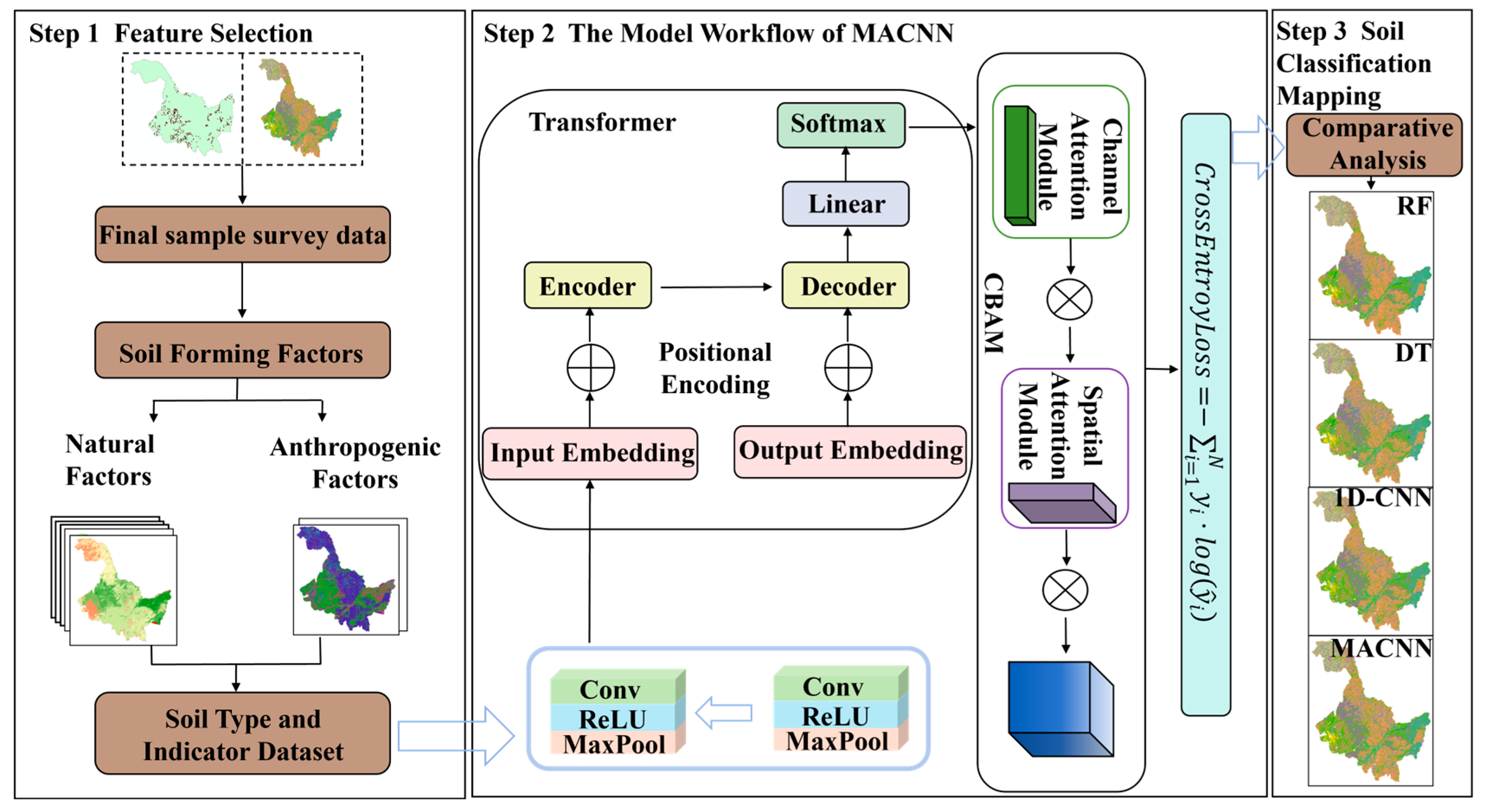
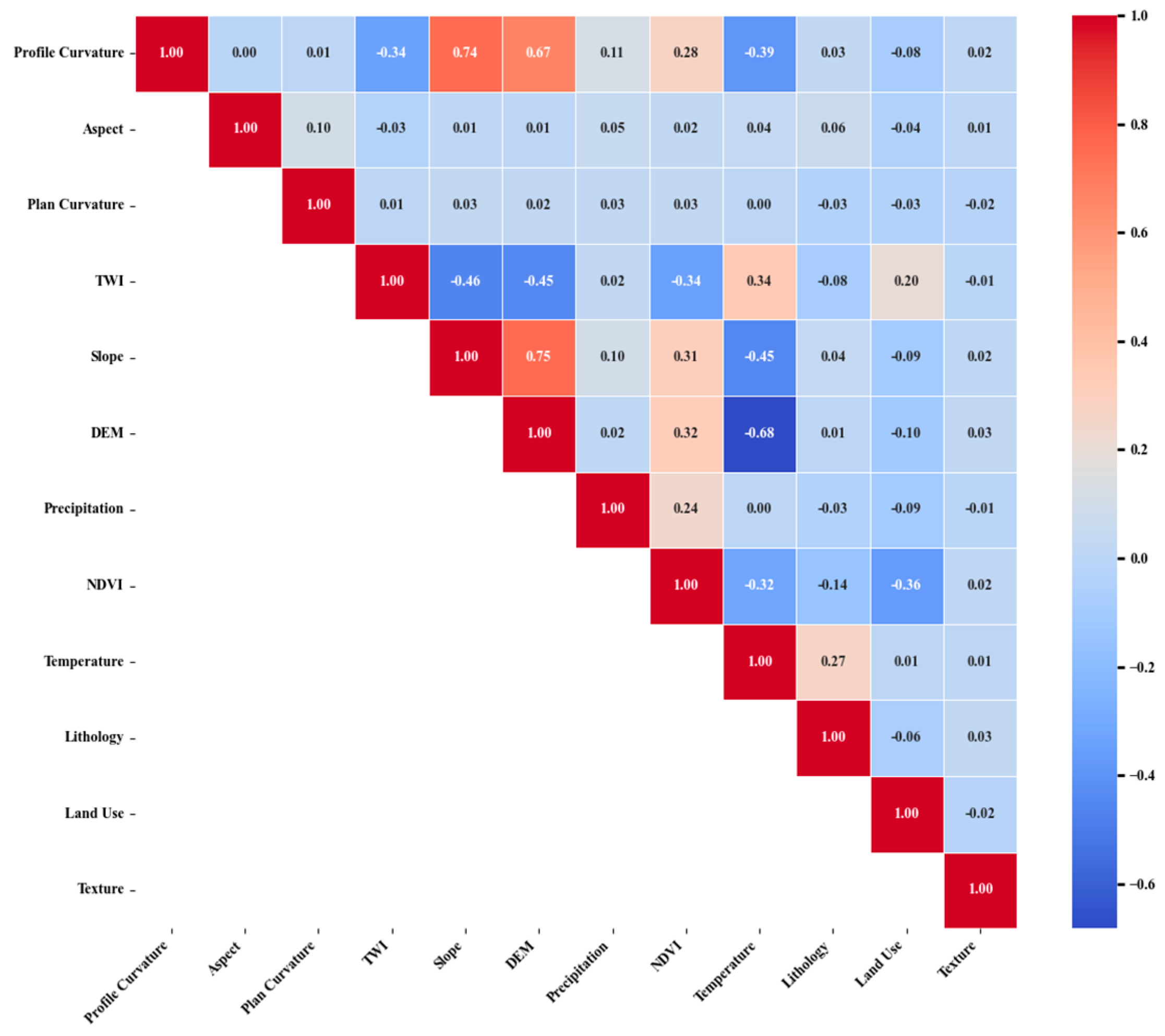
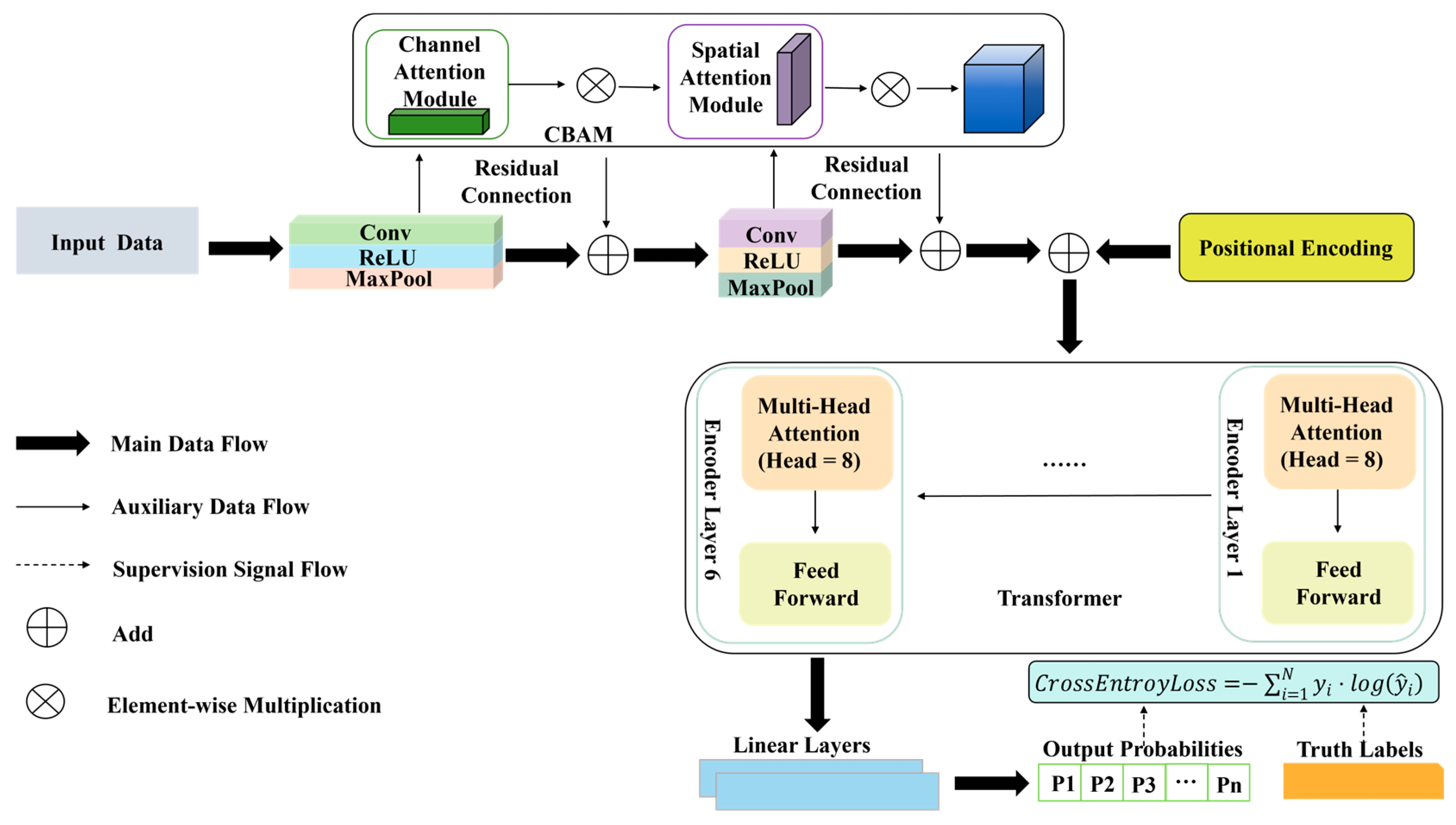

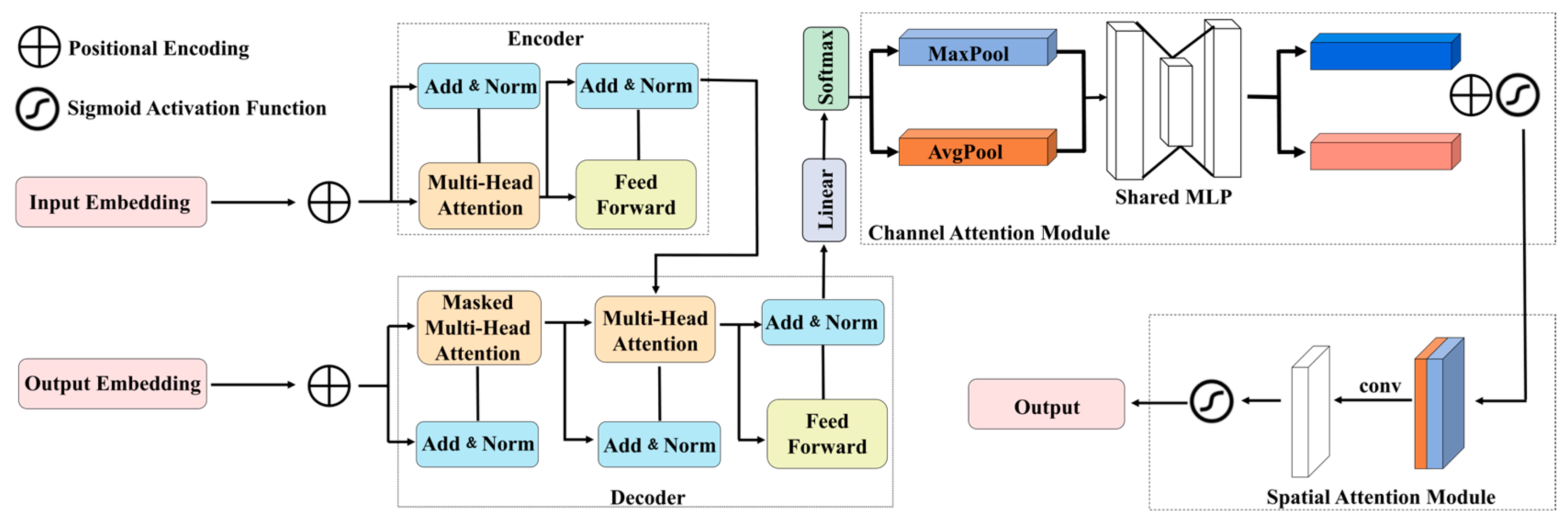

| Environmental Covariate | Data Sources | Resolution (m) | Year |
|---|---|---|---|
| Lithology | Geological Map Sharing Database of the China Geological Survey | 30 | 2015 |
| DEM | NASA’s Land Processes DAAC SRTMGL1v003 | 30 | 2015 |
| Slope | Calculated from DEM | 30 | 2015 |
| Aspect | Calculated from DEM | 30 | 2015 |
| Profile Curvature | Calculated from DEM | 30 | 2015 |
| Plan Curvature | Calculated from DEM | 30 | 2015 |
| TWI | Calculated from DEM | 30 | 2015 |
| NDVI | Sentinel-2 satellite data | 10 | 2015 |
| Land Use | Geographical Monitoring Cloud Platform | 30 | 2015 |
| Texture | National Earth System Science Data Center | 30 | 2015 |
| Temperature | Resource and Environmental Science Data Registration and Publishing System | 1000 | 2015 |
| Precipitation | National Earth System Science Data Center | 1000 | 2015 |
| Environmental Covariates | Tolerance | VIF |
|---|---|---|
| DEM | 0.252 | 3.969 |
| Slope | 0.306 | 3.266 |
| Profile Curvature | 0.411 | 2.432 |
| Temperature | 0.434 | 2.306 |
| NDVI | 0.671 | 1.490 |
| TWI | 0.691 | 1.448 |
| Lithology | 0.827 | 1.209 |
| Land Use | 0.833 | 1.200 |
| Precipitation | 0.907 | 1.102 |
| Aspect | 0.980 | 1.021 |
| Plan Curvature | 0.982 | 1.018 |
| Texture | 0.996 | 1.004 |
| Soil Type | RF | DT | 1D-CNN | MACNN | ||||
|---|---|---|---|---|---|---|---|---|
| UA (%) | PA (%) | UA (%) | PA (%) | UA (%) | PA (%) | UA (%) | PA (%) | |
| Dark-brown earths | 83.94 | 87.65 | 86.08 | 81.33 | 86.71 | 89.76 | 88.17 | 92.16 |
| Albic soils | 60.42 | 72.50 | 49.39 | 60.50 | 71.11 | 64.00 | 71.99 | 73.47 |
| Meadow soils | 77.02 | 59.46 | 71.25 | 54.17 | 68.36 | 77.44 | 77.77 | 78.32 |
| Meadow solonchaks | 27.27 | 60.00 | 20.00 | 40.00 | 28.57 | 40.00 | 85.99 | 89.00 |
| Skeletol soils | 50.00 | 50.00 | 25.00 | 50.00 | 33.33 | 33.33 | 78.53 | 75.00 |
| Aeolian sandy soils | 80.00 | 90.32 | 57.14 | 77.42 | 75.76 | 80.65 | 79.00 | 79.86 |
| Chernozems | 56.77 | 83.87 | 54.82 | 80.65 | 68.39 | 68.39 | 77.53 | 73.53 |
| Black soils | 60.34 | 71,24 | 62.27 | 56.86 | 64.57 | 65.22 | 75.36 | 78.78 |
| Dark felty soils | 0.00 | 0.00 | 0.00 | 0.00 | 100.00 | 00.00 | 71.43 | 62.50 |
| Grey-cinnamon soils | 100.00 | 100.00 | 100.00 | 100.00 | 100.00 | 100.00 | 100.00 | 66.67 |
| Volcanic soils | 100.00 | 60.00 | 66.67 | 60.00 | 83.33 | 50.00 | 88.75 | 78.89 |
| Solonetz | 60.00 | 60.00 | 33.33 | 40.00 | 50.00 | 40.00 | 87.56 | 95.00 |
| Castanozems | 100.00 | 100.00 | 100.00 | 100.00 | 100.00 | 100.00 | 52.38 | 61.11 |
| Peat soils | 66.67 | 60.00 | 35.71 | 75.00 | 100.00 | 40.00, | 77.00 | 42.78 |
| Litho soils | 100.00 | 33.33 | 33.33 | 33.33 | 100.00 | 33.33 | 81.63 | 74.07 |
| Paddy soils | 50.00 | 60.00 | 30.51 | 60.00 | 81.82 | 30.00 | 77.42 | 62.45 |
| Alluvial soils | 41.38 | 63.16 | 23.81 | 52.63 | 75.00 | 15.79 | 55.04 | 42.26 |
| Bog soils | 70.38 | 57.25 | 55.12 | 61.40 | 76.04 | 56.74 | 79.93 | 69.34 |
| Brown coniferous forest soils | 80.49 | 92.77 | 75.36 | 83.53 | 84.64 | 90.76 | 84.87 | 87.98 |
| OA (%) | 73.62 | 67.76 | 76.07 | 81.27 | ||||
| Kappa Coefficient | 0.6764 | 0.6083 | 0.6996 | 0.7681 | ||||
| Algorithm | Recall | Precision | Macro-F1 Score |
|---|---|---|---|
| RF | 66.40% | 66.56% | 64.54% |
| DT | 61.41% | 51.57% | 54.83% |
| 1D-CNN | 61.86% | 76.19% | 65.42% |
| MACNN | 72.80% | 78.44% | 75.00% |
| 1D-CNN | CBAM | Transformer | Accuracy | Recall | Precision | Macro-F1 Score |
|---|---|---|---|---|---|---|
| √ | 76.07% | 61.86% | 76.19% | 65.42% | ||
| √ | √ | 76.80% | 65.70% | 75.64% | 68.38% | |
| √ | √ | √ | 81.27% | 72.80% | 78.44% | 75.00% |
Disclaimer/Publisher’s Note: The statements, opinions and data contained in all publications are solely those of the individual author(s) and contributor(s) and not of MDPI and/or the editor(s). MDPI and/or the editor(s) disclaim responsibility for any injury to people or property resulting from any ideas, methods, instructions or products referred to in the content. |
© 2025 by the authors. Licensee MDPI, Basel, Switzerland. This article is an open access article distributed under the terms and conditions of the Creative Commons Attribution (CC BY) license (https://creativecommons.org/licenses/by/4.0/).
Share and Cite
Liu, Y.; Li, H.; Pan, Y.; Gao, Y.; Zhou, Y. A Study on Digital Soil Mapping Based on Multi-Attention Convolutional Neural Networks: A Case Study in Heilongjiang Province. Agriculture 2025, 15, 2273. https://doi.org/10.3390/agriculture15212273
Liu Y, Li H, Pan Y, Gao Y, Zhou Y. A Study on Digital Soil Mapping Based on Multi-Attention Convolutional Neural Networks: A Case Study in Heilongjiang Province. Agriculture. 2025; 15(21):2273. https://doi.org/10.3390/agriculture15212273
Chicago/Turabian StyleLiu, Yaxue, Hengkai Li, Yuchun Pan, Yunbing Gao, and Yanbing Zhou. 2025. "A Study on Digital Soil Mapping Based on Multi-Attention Convolutional Neural Networks: A Case Study in Heilongjiang Province" Agriculture 15, no. 21: 2273. https://doi.org/10.3390/agriculture15212273
APA StyleLiu, Y., Li, H., Pan, Y., Gao, Y., & Zhou, Y. (2025). A Study on Digital Soil Mapping Based on Multi-Attention Convolutional Neural Networks: A Case Study in Heilongjiang Province. Agriculture, 15(21), 2273. https://doi.org/10.3390/agriculture15212273


