Article

GIS-Based Land Suitability Analysis for Sustainable Almond Cultivation in Lebanon

1
Department of Agricultural Sciences, University of Sassari, 07100 Sassari, Italy
2
Department of Environment and Natural Resources, Lebanese University, Beirut P.O. Box 6573/14, Lebanon
*
Author to whom correspondence should be addressed.
Agriculture 2025, 15(18), 1974; https://doi.org/10.3390/agriculture15181974
Submission received: 20 August 2025 / Revised: 14 September 2025 / Accepted: 16 September 2025 / Published: 19 September 2025
(This article belongs to the Section Ecosystem, Environment and Climate Change in Agriculture)

Abstract

Almonds are one of the major products that are economically competent and compatible with the Mediterranean climate, a key characteristic that distinguishes Lebanon. The present study aims to examine the suitability of land use and land cover on the Lebanese territory for sustainable almond cultivation, based on the FAO land suitability criteria. The research explored the existing areas of almond cultivation and the land possessing the potential for almond cultivation in Lebanon using an analysis model developed on GIS. The evaluation of Land Suitability (LS) based on GIS and Multi-Criteria Evaluation methods (MCE) with Weighted Overlay (WO) was applied, and the almond suitability map was rendered using the seven following parameters: temperature, rainfall, slope, elevation, soil pH, soil texture, and soil depth. These variables were integrated through GIS and were allocated to different weights to each thematic layer, as per its relevance. Ultimately, the almond suitability map was established, comprising four categories: highly suitable, moderately suitable, marginally suitable, and not suitable. The obtained results indicated that almond cultivation areas were around 5500 ha in 2010, while more than 60% of the study area can be planted with almonds in accordance with the almond suitability map. In closing, the targeted decision-makers will potentially deem this study as a valid source of knowledge for planning land use, and a tool to mitigate land degradation.

1. Introduction

Almond production is a significant component of Lebanon’s agricultural sector, as it has reached 31,863 tons in 2022, thus providing both economic value and ecological resilience in semi-arid and Mediterranean areas [1]. In recent decades, there has been considerable concern over environmental degradation, ecosystem destruction, habitat loss, and the global depletion of natural resources [2]. This is largely attributed to the population growth, the massive quantities of agrochemicals being used, the exploitation and abuse of natural resources, the invasion of exotic species, and the cultivation of competitive or more productive cultivars [3,4]. Land suitability analysis has become nowadays an efficient tool for addressing these issues and establishing a viable and sustainable agroecosystem.
Almond trees, distinguished by their adaptability, can be effectively incorporated into existing systems, optimizing land usage and creating synergies with intercropped species. Achieving the ultimate sustainability of this kind of farming notably depends on the accurate analysis of land suitability.
The determination of land suitability is defined as a method of identifying land potential for different land use practices (agriculture, recreation) [5,6]. Land suitability analysis for plant cultivation remains an appropriate approach for assessing the potential crop patterns, initiation, and practices [7]. More precisely, a land suitability assessment will suggest whether—or not—to grow a specific crop in a given area: the definition of the criteria that influence the suitability of the land is a central part of this process [6,8].
The ArcGIS Desktop version 10.7.1 (ESRI) presents an effective tool for land use suitability in agricultural development plans of a region [7], and one of the main usages of GIS is land use suitability mapping and analysis [9]. Spatial parameters such as climate, soil, land cover, and topography can be handled together for land assessment, which can define appropriate areas for planting activities to address property owners’ objectives as well as farmers’ concerns.
Almond (Prunus dulcis), pertaining to the Rosaceae family, is one of the world’s most prevalent tree nuts, and is ranked first in terms of production [10]. The sweet almond is a stone fruit that grows commercially in areas with long, sunny, and hot summers, such as those in California (USA), Australia, Spain, Lebanon, and Italy. In Lebanon, the almond cultivations are mainly constituted by local cultivars, used for the fresh green or dried food production. Several varieties, mainly “Tuono”, “Texas”, “Ferragnès” and “Supernova” have been lately imported; their late blooming feature stands out as a distinctive advantage that protects them from the spring frost [11].
Many environmental factors in Lebanon—in particular spring frosts—place almond cultivation at risk [11]. Even though almonds are tolerant to low winter temperatures, low spring temperatures during flowering are fatal to their reproductive organs. On the other hand, higher temperatures, which contribute to premature bud outbreaks, raise the susceptibility to spring frosts. Traditional almond cultivars, which are mostly early bloom varieties, are extremely exposed to frost damage.
The general scope of this research is to determine the suitable locations in Lebanon for the development of almond trees, using a specific model that is focused on multi-criteria spatial analysis. The selection of the most suitable areas for growing almond trees is established through an assessment of the climatic, edaphic, and topographical conditions, as well as the identification of existing biophysical constraints. Many factors are implicated in this situation, and each should be weighted according to its respective relevance to optimal conditions for crop growth as per the outputs of both the multi-criteria assessment and GIS, since advanced GIS modeling tools possess the ability to map this field theoretically and coherently. Consequently, and based on the definition of the plant’s environmental requirements, the output renders a map displaying the suitable locations for almond trees, which will be an essential indicator for decision-makers, providing them with strategic aspects of land use planning and land loss mitigation, thus leading to the development of a safer and more resilient future livelihood.
Land suitability denotes the relative capability of a parcel of land to produce a given crop in a sustainable way. Its assessment elucidates the restrictions and benefits for the exploitation of the land and consequently leads to the foremost use of resources, which is a crucial requirement for land use planning and development [12].

2. Materials and Methods

2.1. Site Description

The studied area is the whole territory of Lebanon, which is located on the eastern shore of the Mediterranean Sea [13]. It is located at coordinates between 33°3′18″ N to 34°41′29″ N and 35°6′9.45″ E to 36°37′18.60″ E, Datum WGS 1984, and occupies 10,452 km2 [13]. The nation has four different zones from west to east [14]: the coastal strip, the Mount Lebanon Range, the fertile Bekaa Plain, and the Anti-Lebanon Range, defining its Syrian border.
Lebanon is a coastal Mediterranean country characterized by different microclimatic conditions [14]. While the coastal plains are typically Mediterranean, characterized by a long hot summer and a mild winter (with frost risk almost non-existent), the adjacent Mount Lebanon Mountains (up to 3081 m) are chilly and covered with snow from December until May [14]. A semi-arid climate dominates in the inland Bekaa plain, depicted by some snow, frost, and low rainfall during the winter and early spring seasons. The main renewable source of water in the country majorly results from precipitations (rain and snow), as the annual rate varies between an average of 340 mm in the coastal area and an average of 1300 mm along the Western Mountain chains. It shall be noted that, in the Bekaa valley, rainfall incrementally decreases in the positive latitude bearing, that is, as we navigate in the South-to-North direction.
According to the rainfall level, topography, soil type, and the availability of water for irrigation, several agro-ecological zones can be distinguished, hosting approximately 3000 wild species and permitting massive crop cultivation [14].

2.2. Methodology Used

The main goal of the study is to delineate the suitable areas for almond cultivation using the relevant variables of soil, climate, land use/land cover, and topographic factors using Geographic Information System (GIS)-based multi-criteria overlay analysis techniques (Figure 1). Generally, one of the main usages of GIS is land use suitability mapping and analysis [9]. The incorporation of analytical techniques conceived to work with multi-criteria evaluation problems within GIS may provide more advanced tools for the user [15]. Accordingly, the integration of multi-criteria assessment within a GIS framework helps users technically improve decision-making procedures; it is also an impressive technique for land-suitability evaluations [16].
The methodology for the delineation of the crop suitability map for a predetermined area implies the management and integration of a set of layers, which are deemed as the major drivers for land suitability. In the land suitability evaluation through GIS, each grid cell in the database is taken as an alternative to be analyzed for its reliability and validity for a given interpretation, and each thematic layer defines a criterion for the evaluation [17].
Each criterion is generally evaluated with four classes [18]:
  • “Highly suitable (S1): Land having no significant limitations to the sustained application of the considered use, or only minor limitations that will not significantly reduce productivity or benefits and will not raise inputs above an acceptable level.
  • Moderately suitable (S2): Land having limitations that in aggregate are moderately severe for the sustained application of the considered use. The limitations will reduce productivity or benefits and increase the required inputs to the extent that the overall advantage to be gained from the use, although still attractive, will be appreciated as inferior to that in class S1 land.
  • Marginally suitable (S3): Land having limitations which in aggregate are severe for the sustained application of the considered use and will reduce productivity or benefits or increase the required inputs to the extent that this expenditure will be only marginally justified.
  • Not suitable (N): Land having limitations which appear very severe as to preclude any possibilities of successful sustained use of the land in the given manner, or the limitations may be surmountable in time but cannot be corrected with existing knowledge at the currently acceptable cost.
Suitability analysis is a typical multi-criteria decision-making (MCDM) problem [19], where several biophysical criteria are evaluated. The results of the MCDM are subsequently integrated into a Geographic Information System (GIS) to perform spatial analysis and generate suitability maps through Multi-Criteria Evaluation (MCE). Spatial analysis can be defined as follows: “that subset of analytic techniques whose results depend on the frame, or will change if the frame changes, or if objects are repositioned within it” [20].
A general model of land suitability can be expressed as follows [19]:
S = f (x1, x2…, xn),
where
S: Suitability degree and x1., x2, …, xn: the factors affecting the suitability of the land.

2.3. Identification of Criteria Influencing the Crop Suitability

The Weighted Overlay tool integrates one of the most widely used overlay analysis methods to overcome multi-criteria problems like site selection and suitability models. The Weighted Suitability Model is generated via spatial analysis for defining suitable locations for almond cultivation depending on many thematic layers (criteria layers), and based on the principle of Multi-Criteria Evaluation (MCE), where numerous criteria must be evaluated to reach a particular objective [21].
For a successful land suitability setup, the selection of relevant assessment criteria is crucial. As almonds are biological structures, most considerations should point to their ecological and biological features. The evaluation factors assigned in this research were derived from considerable literature exploration.
1-
Climate: precipitation and temperature;
2-
Soil:
-
Physical properties: depth and texture;
-
Chemical properties: pH;
3-
Topography: slope and elevation;
4-
Current land use/land cover.
The stated layers represent the criteria describing the suitability of the land in a specific area for almond cultivation (Table 1).
The layers combination technique follows the conventional scheme for Multi-Criteria Evaluation (MCE), a GIS-based implementation of the broader Multi-Criteria Decision-Making (MCDM) framework [22].
Table 1. Selected environmental and soil factors specific to almond tree (Prunus dulcis) affecting its natural distribution.
FactorsOptimal Value
for Almond/Almond
Preferences
Bioclimatic Data
(Downloaded from Different Sources)
Climatic Factors
Minimal temperature during December, January, February, and MarchCold needs to break the dormancy: the total number of hours below 7 °C
The chill fraction is more tightly related to the mean winter temperature than the mean annual temperature [23,24]
Beginning of blooming buds can resist until −3 °C and −4 °C [25,26]
Full bloom stage: −1 °C and −2 °C are lethal
Young fruits: −0.5 °C is lethal [27,28]
Minimal temperature from December to March
Average monthly temperature in °C (mean T°)
Source: http://worldclim.org/version2 (accessed on 14 March 2020) [29]
PrecipitationMinimal value: 400 mm [30]
400–1470 mm annual rainfall [28]
With an optimum of 800 mm [30]
Almond trees can survive on as little as 180 mm of water annually and respond to increased water applications with increasing yield [31,32]
Mean (Cumulative) Annual Precipitation (mm)
Source: http://worldclim.org/version2 (accessed on 14 March 2020) [29]
Topographic Factors
Slope>6% [5]Slope
Source: from DEM
DEM from CNRS [33]
Elevation<1200 m
Optimum 750 m [34]
Altitude
Source: from DEM
DEM from CNRS [33]
Edaphic Factors
Soil TextureNon-stratified, medium, and moderately fine-textured loamy soils [35]Clay, Silt, Sand percentage
Source: Soil map CNRS [33]
Soil Depth>80 cm [27]Soil depth
Source: Soil map CNRS [33]
Soil pHpH: 5.3–8.3 [28,36]
limiting value: <5.0
Soil pH
Source: Soil map CNRS [33]

2.4. Data Acquisition

We applied the high spatial resolution climate datasets of WorldClim (30 arc-s, ~1 km at the Equator) [37]. We opted for WorldClim owing to its high spatial resolution, superior quality, and widespread application (more than 15,000 citations). WorldClim dealt with data from more than 47,000 weather stations from 1950 to 2000 worldwide as input to generate interpolations. Furthermore, WorldClim correlates well with other universal datasets, particularly in high-density zones of weather stations [37].
Soil properties such as texture, pH, and soil depth influence almond yields. In fact, the yield of almonds is highest in deep, permeable soil with a good water-holding capacity or with irrigation during the growing season, whereas compacted soil with poor drainage impedes root growth. Thus, the well-drained loamy soils with good moisture-holding capacity are the best soil types for almond tree growth. Neutral and alkaline soils (with pH ranging between 7.3 and 8.1) are most suitable for almond growth.
The root apparatus of almond species is well developed and characterized by a deep root system. Since the almond taproot can reach depths greater than 1.8 m [38], it could take up nutrients from deeper layers within the soil.
Almond trees require a Mediterranean climate with mild, wet winters and hot, dry summers. Temperature, precipitation, and frost risk are vital factors to study. The optimal precipitation for almond growth extends from 800 to 1100 mm [30]. However, growth can be suitable at lower amounts of precipitation, where additional irrigation is supplied. Frequent rainfalls and cold weather during the flowering period deteriorate the cross-pollination activity of bees, resulting in decreased fruit set and production. Rainfall and humid conditions favor the development of fungal and bacterial diseases and reduce almond production.
The optimal mean annual temperature varies between 10.5 and 19.5 °C [28] with an optimal mean temperature from 2 to 7 °C during the dormancy period (mid-November to January) to accumulate the chilling hours requirements. Temperatures below −2 °C are harmful to buds during December and January. Throughout the blooming period (March–April), a temperature below −1 °C led to flowers injury, which affected the yield [27,28]. Most almond orchards growing in Lebanon are constituted of local traditional varieties e.g., ‘Khachabi’, ‘Halawani’, and ‘Om Omar’, which are known to be early in flowering and susceptible to frost.
Moreover, topographic features such as slope and elevation affect the suitability of land for almond cultivation. Topography designates the layout of the land surface, whereas the dominant slope is the most influential differentiating factor [39]. The slope gradient variability is fundamental, mainly for drainage, erosion, and irrigation as this parameter is represented by different classes (Table 2).
Slope or inclination of a land is defined as “the measurement of the rate of change of elevation of the land per unit distance” [40]. Since the steeper slopes cause easier flow of water, soil degradation and soil erosion are greater, and soil cannot retain moisture for a longer period. Land with gentle slopes can be ideal for plant growth because water remains for a longer period and supplies sufficient humidity to the soil. As a result, gentle slopes are preferred to steep slopes for agroforestry [40].
The almond tree should be planted on slopes at high elevations to escape frost, and should not be planted on the floors of valleys where it can be subject to soil drainage problems, frost hazards, and competition with other crops [36,41]. Only areas with slopes greater than 6% are recommended for almond growth [5]. Areas with slopes of less than 6% are rather suited for growing vegetables or field crops, which may provide higher profit in a short time when irrigation starts.

2.5. Crop Requirement Characteristics and Criteria Layers Creation

For the scope of this study, the assessment of the crop requirement characteristics for almond concerning the above selected criteria was based on a large literature review.
Environmental requirements are elucidated by respectively specifying optimal, moderate, marginal, and unsuitable conditions (Table 3) for each factor that affects plant development, and they are accordingly reported in different suitability classes [18].
In ArcGIS 10.7.1 software, developed and managed by the Environmental Systems Research Institute (ESRI), all the spatial data were converted into raster layers and georeferenced to the UTM Zone 36N coordinate system.
The soil data source was RSC, CNRS (Remote Sensing Center, National Council for Scientific Research). The new detailed soil map of Lebanon at a scale of 1:50,000 was produced during 1997–2006. This feature dataset describes the different soil types. The 27 sheets were produced by Darwish et al. [42]. The scale of the original map (metadata) was 1:50,000. The processing steps comprised the following:
-
Raster projection in the UTM Zone 36N coordinate system;
-
Creation of the raster layers: vector to raster geoprocessing tool (rasterization) for the depth, the pH, and the texture;
-
Resample: Change the spatial resolution of the raster dataset and set rules for aggregating or interpolating values across the new pixel sizes. The cell size of the raster data was 30 × 30;
-
Reclassification of the raster layers according to the four classes of suitability as described in the almond requirement table (Table 3). The numbers from 1 to 4 were applied to assign a code to the four suitability classes from highly suitable to not suitable, respectively.
The topography data source was RSC, CNRS. The DEM layer was generated from 10 m contour lines that were digitized. The processing steps comprised the following:
-
Raster projection in the UTM zone 36N coordinate system;
-
Calculation of the slope raster in percentage;
-
Resample: Change the spatial resolution of the raster dataset and set rules for aggregating or interpolating values across the new pixel sizes. The cell size of the raster data is 30 × 30;
-
Reclassification of the raster layers according to the four classes of suitability as described in the almond requirement table (Table 3). The numbers from 1 to 4 are applied to assign a code to the four suitability classes from highly suitable to not suitable, respectively.
The mean of four monthly climate data for the minimum temperature of December, January, February, and March, and the mean annual precipitation are considered for the almond requirements. The source was WorldClim 2.0 climate data for 1970–2000 [29]. Metadata comprised raster layers with 30 arc-seconds resolution downloadable as a tile of 30 × 30 degrees. The processing steps were as follows:
-
Download of the 12 tiles of precipitation and the four tiles of mean minimum temperature;
-
Clipping of the two climate tiles by the watershed boundaries;
-
Calculation of the mean annual precipitation and of the mean monthly minimum temperature of December, January, February, and March by using the raster calculator;
-
Resample: Change the spatial resolution of the raster dataset and set rules for aggregating or interpolating values across the new pixel sizes. The cell size of the raster data is 30 × 30;
-
Reclassification of the two-climate raster according to the four classes of suitability as defined in the almond requirements table (Table 3). The numbers from 1 to 4 are applied to assign a code to the four suitability classes from highly suitable to not suitable, respectively.

2.6. Criteria Maps Reclassification and Creation of the Almond Suitability Maps

The seven parameters stated for this study have been selected to form the thematic layers for the overlay weighted model analysis. Each parameter has a set of classifications and relative weight values that influence the model’s final decision. Each criterion map should be normalized and reclassified using the Spatial Analyst Reclassify tool of the Arc-GIS 10.7.1 program. This step is necessary because the criterion maps contain the ordinal values (high, medium, and low) that indicate the degree of land suitability according to a specific criterion.
The suitability map is obtained by overlaying the previous maps. The geographical limits for the different variables are used as aptitude classes: highly suitable, moderately suitable, low or marginally suitable, and not suitable, which are defined and mapped. According to the results, the country’s geographic areas that do not meet almond culture conditions will be masked and qualified as not suitable areas. This final part consists of two main steps:
-
Designation of the weights for the criteria: Soil features (pH, texture, and depth), precipitation, temperature, slope, elevation, and land use/land cover;
-
Weighted overlay analysis.
Each of the criteria in the weighted overlay analysis may not be equivalent in importance. The weighing in land suitability analysis for agricultural crops aims to reveal the importance or preference of each factor relative to other factors’ impacts on crop yield and growth rate. Each raster was given a percentage impact based on its significance. The weight was taken as a percentage, and the total of the percent impact weights must be equal to 100. To generate the output raster, each cell value was multiplied by its percentage effect and then integrated. To achieve a suitability value for each position or location on the map, each raster cell was reclassified into units of suitability, multiplied by a weight to allocate the relative importance to each, and eventually added together for the final weight [43]. It can be summarized in the following Equation:
S = Σ Wi × Pi
where
S = suitability index;
Wi = the weight of each parameter Pi;
Pi = parameters selected for this study (Soil Texture, Soil pH, Soil Depth, Altitude, Slope, Temperature, and Rainfall). The weights can be adjusted to make all the parameters’ combined weights equivalent to 1.
The weighted overlay analysis is a component of spatial modeling using spatial multi-criteria evaluation. The weighted overlay analysis allocates more importance to some criteria over others.
Once all the necessary thematic layers and weighting scheme for the weighted model had been developed, the final model could be built and run on ArcGIS, resulting in the most favorable sites selected using the criteria previously mentioned.
The seven parameters’ weights are assigned to the corresponding layers in the ArcGIS 10.7.1, and raster maps of each parameter are overlaid using the Weighted Overlay Analysis (WOA) in raster calculator tools. Based on the weights assigned to each criterion, an integrated layer was created, revealing four classes according to the land suitability classification of FAO [18] including highly suitable (S1), moderately suitable (S2), low or marginally suitable (S3), and not suitable (N) sites for almond culture.

3. Results

3.1. Vocational Analysis of the Lebanon Land for Almond Cultivation

3.1.1. Creation of the Soil/Topography/Climate Suitability Maps

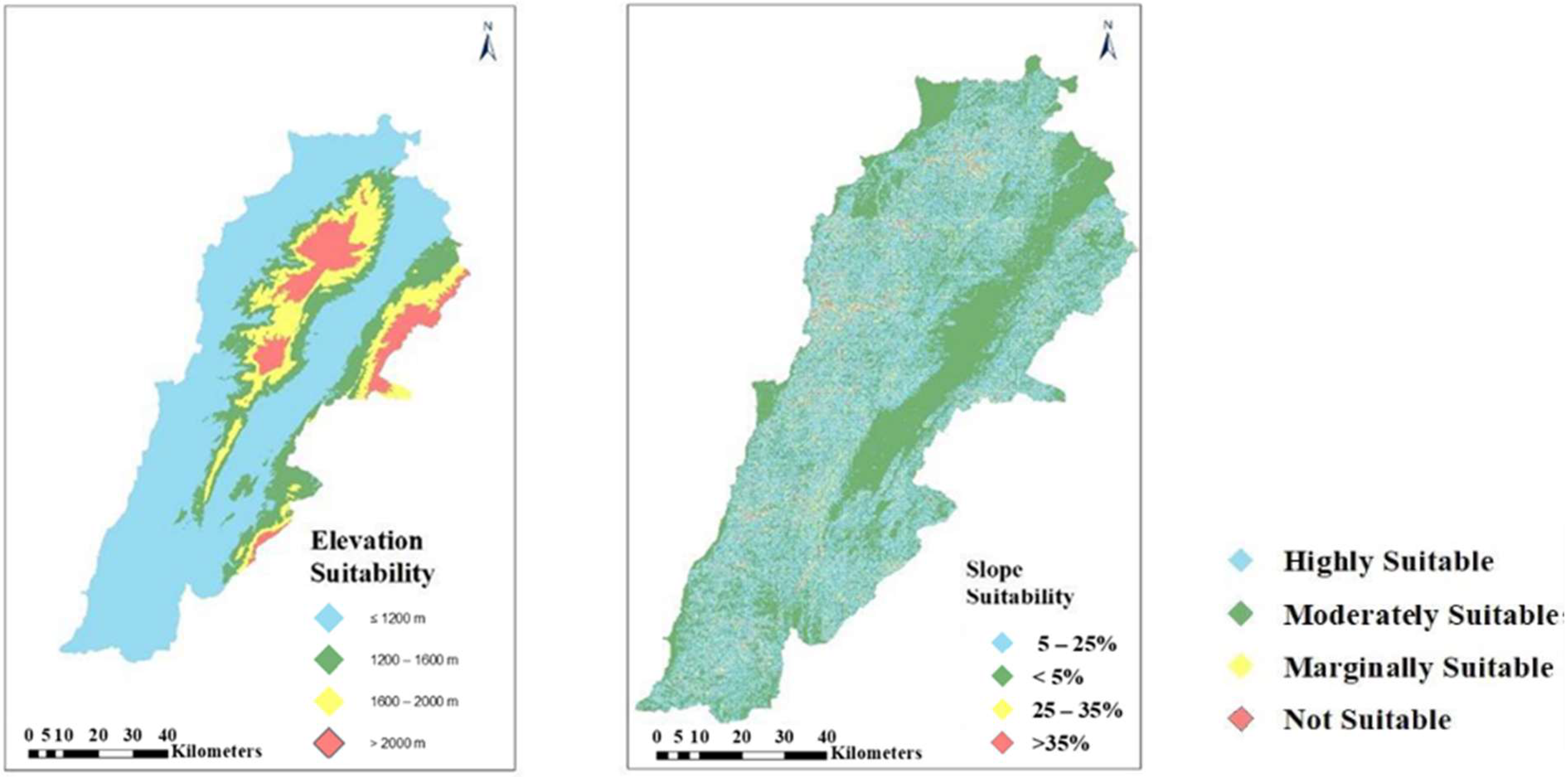
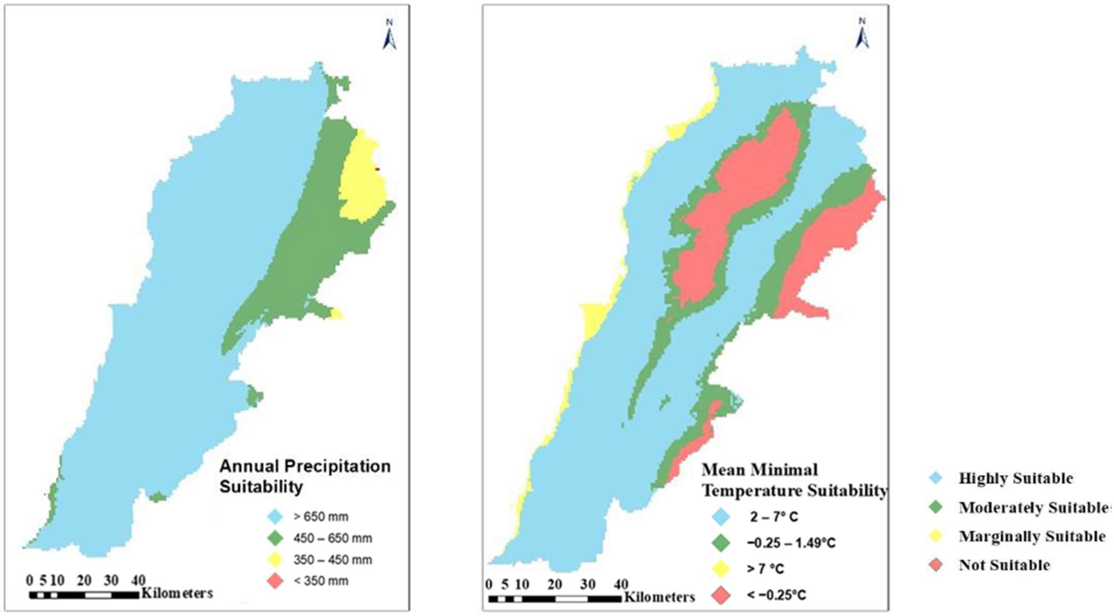
Overlaying multiple thematic maps to obtain fruitful conclusions is the most useful exploitation of GIS in resource data analysis [44]. The factors that may affect land suitability for almond have been identified, and a GIS-based thematic database on soil pH, soil depth (Figure 2) and soil texture (Figure 3), slope and elevation (Figure 4), minimal temperature and rainfall (Figure 5) has been developed.
All these generated thematic layers constitute the input in an overlay-weighted model. They are integrated in ArcGIS 10.7.1 platform to create a map representing suitable areas for almond plantation.

3.1.2. Land Occupancy

To determine suitable areas for almond cultivation, it is essential to exclude the lands that are uncultivable from the land use/land cover map [33]. The land use map consists of four levels of classification. The first level comprises nine classes: artificial areas, agricultural areas, woodland, grassland, wetland, unproductive areas, water bodies, water courses and roads network and sixty-six subclasses. Consequently, the regions like artificial areas, wetland, unproductive areas, bare rocks, water bodies, and roads network are reclassified into uncultivable areas (Figure 6). This figure shows that about 64% of Lebanon’s territory is a cultivable area without taking into consideration the policies and the zones classification according to the Higher Council for Urban Planning.

3.2. Almond Suitability Map

3.2.1. Criteria Weights Assignment

Weights for the MCE evaluation were assigned using a combination of expert consultation and literature review (Table 1). Previous studies [45,46,47] indicate that temperature and precipitation (or soil moisture) are the primary climatic determinants of almond suitability, ecological adaptation, and productivity and that the tree yield is directly correlated with the availability of water [48]. Furthermore, research that focuses on particular cultivars [49] shows that the temperature during flowering is frequently the most restrictive climatic factor.
To supplement this data, a series of interviews were undertaken with local agronomists and soil experts (n = 20 experts), who were asked to assign 100 points to the selected parameters based on their estimated relevance. To establish consistency, the mean scores collected through expert consultation were then compared to literature-reported values and thresholds. In cases where disparities had been identified, the literature was given the highest priority for climatic criteria (temperature and rainfall), as their impact on almond characteristics and yield has been carefully evaluated in prior studies. The elevation was allocated a very high weight (25%) [47] in this analysis because of its importance in determining frost occurrence.
For edaphic factors, greater reliance was placed on expert judgment, as these parameters are highly site-specific and often not sufficiently represented in international guidelines.
Since almond production relies mostly on climatic conditions (temperature and rainfall), a higher weight was assigned to the climatic criteria (40%): 20% to the rainfall (R) and 20% to the temperature (T). Concerning the edaphic criteria (25%), a higher weight was assigned to the texture (Tx) (10%) and the depth (D) (10%), while the pH had the lowest weight (5%). It should be noted that among the topographic criteria (35%), the elevation (E) (25%) plays a major role in the delineation of suitable areas for almond cultivation, and a final weight of 10% is assigned to the slope (S) (Table 4).
The Land Suitability (LS) model equation is as follows:
LS = 0.2T + 0.2R + 0.1Tx + 0.1D + 0.05pH + 0.25E + 0.1S
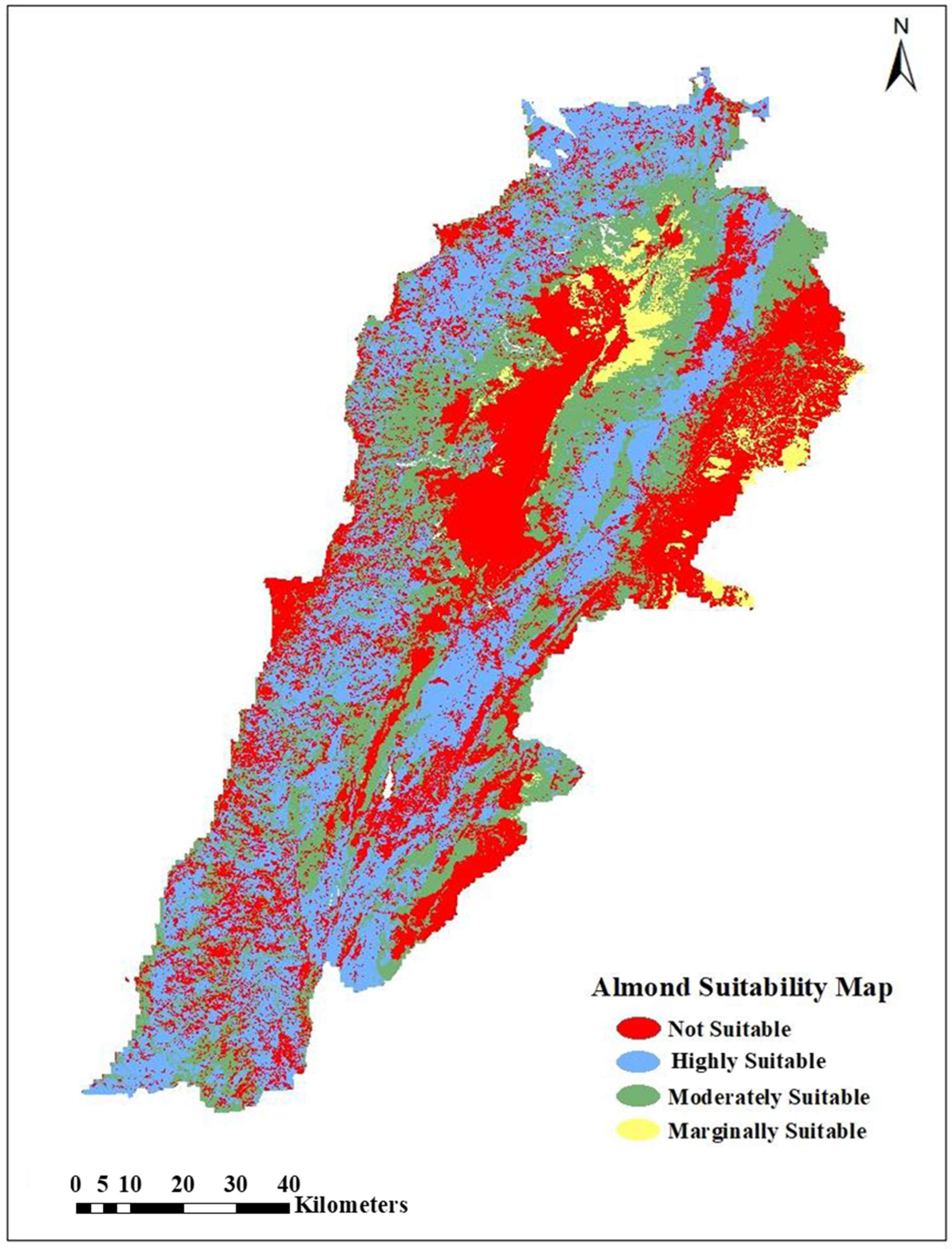
After applying the weighted linear combination (S = Σ Wi × Pi), the resulting composite suitability index was reclassified within the GIS environment. Reclassification was carried out according to the FAO land suitability framework, which defines four categories: highly suitable (S1), moderately suitable (S2), low or marginally suitable (S3), and not suitable (N), thereby converting the continuous output into the categorical map shown in Figure 7.

3.2.2. Suitability Map

Following the elaboration of all the thematic layers and the table of weights required for the weighted model, the weighted model could be designed and run on ArcGIS, yielding the most suitable sites based on the parameters previously stated. Consequently, the thematic map (Figure 7), covering from highly suitable to not suitable land, was generated through the combination of the different geographic layers, which are overlaid as per their relative importance based on the weights assigned to each criterion.
Figure 7 exhibits an obvious demarcation of highly suitable land for almond cultivation. The latter class covers an area of 336,972 hectares, and about 294,120 hectares were deemed as moderately suitable land. These two main classes are regarded as preferences for almond tree use.
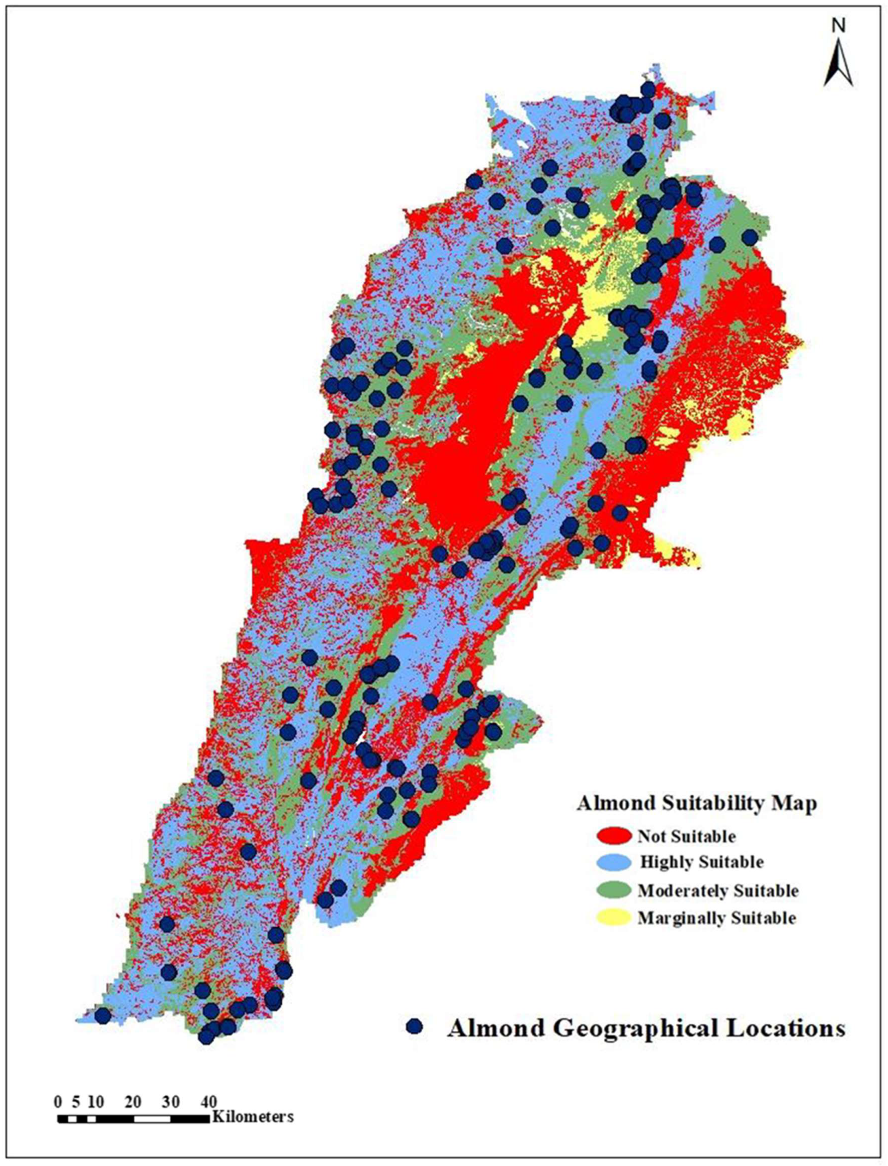
Finally, the suitability map must be checked and validated to ensure that the results are correct. To this end, many field visits have been conducted using the Global Positioning System (GPS), and many points were collected from the actual locations of almond trees. This explicitly shows that the majority (more than 95%) of the existing almond trees were situated in the high and medium suitability classes (Figure 8), providing validity to the established suitability map.

4. Discussion

Regarding the soil texture, about 40% of the Lebanese soils, which are loamy soils, are suitable for almond cultivation (Figure 3) and are characterized by their richness in nutrients and organic matter, as well as by their ability to retain water while allowing water surplus to flow away. Lebanon has a notably large area of clay soils (38.69%), which are not suitable for almond plantation due to their tendency to be waterlogged. To cope with this issue, the farmers were constrained to apply the appropriate soil management practices such as amendments and tillage.
Waterlogging is the most significant constraint of almond cultivation. A soil depth greater than 100 cm has been found to be optimal for almond growth, which corresponds to 47.72% of the Lebanese soils (Figure 2).
Soil pH is already critical since soil acidity and alkalinity affect the accessibility of nutrients to the plant’s roots. The pH reflects the solubility and therefore the potential availability or phytotoxicity of the different elements, thus identifying the most suitable soil for a specific crop [50]. Soil nutrients like potassium, nitrogen and phosphorus are adsorbed when dissolved in soil moisture [40].
There is almost no problem with the soil pH since the majority of the soil in Lebanon (96.41%) is neutral to slightly alkaline (pH = 7 and 8), thus highly suitable for almond (Figure 2).
In Lebanon, 64.25% and 78.32% of the areas are suitable for almonds based on the minimum temperature and rainfall amount, respectively (Figure 5). Approximately 16.8% of the land is unsuitable for almond cultivation due to a high risk of frost. Most continental areas, where the average minimum temperature ranges between −0.25 °C and 2 °C, are considered moderately suitable. Topographic characteristics such as slope and altitude influence not only the suitability of land for almond cultivation, but also affect temperature and moisture distribution [51]. The almond trees grow better on a slope between 5 and 25% for best drainage since almonds do not support the waterlogged soils. About half of the land in Lebanon are suitable for almonds according to the slope factor. As a resilient and thermophilic species, almonds can grow in a wide range of altitudes, reaching up to 1200 m (Figure 4).
The final almond suitability map produced, shown in Figure 7, was carried out through ArcGIS 10.7.1. The visual output showed that 32.24% of the Lebanese area can be categorized as highly suitable, while 28.14% is deemed moderately suitable for almond growth. These results, confirmed by the observation in the field, suggest that almonds are well adapted to the present Mediterranean semi-arid conditions, particularly in rainfed environments. To this end, highly suitable areas are characterized by an excellent potential for sustainable and self-governing yield, while moderate suitable areas imply a relatively good potential, which might ultimately require supplementary intervention such as agroforestry integration, soil conservation practices, or supplemental irrigation to alleviate limiting factors.
Yet, as with most land suitability assessments, these classes embody static conditions, where agriculture is dynamic. It shall be noted that almonds are perennials with high sensitivity to temperature regimes, especially chilling requirements and bloom phenology. Indeed, other regions offer considerable evidence for this. In their study, Parker and Abatzoglou (2018) [52] traced the thermal niche of almonds in California, providing evidence that warming plays a compressing role through the flowering and harvesting periods, thus reducing chill accumulation and altering the geographic distribution of suitable areas. This implies that a land preliminarily considered highly suitable might experience an incremental decrease in productivity in future decades, in the case that climate trajectories continue to warm up.
Furthermore, the Regional Mediterranean studies strongly underpin this concern. A Portuguese assessment of climate change impacts on chestnut and almond species [53] showed that in the case that no adaptation measure is pursued, both crops will be subject to yield reductions under hotter and drier conditions. The latter highlights numerous strategies, including shifting cultivation to higher altitudes, adopting drought and heat-tolerant varieties, and enhancing water use efficiency through precision irrigation and/or rainwater harvesting. On the other hand, the case emphasized that diverse selection is as significant as land management when it comes to achieving sustainable and long-term productivity. In this context, the introduction and promotion of late-blooming almond cultivars in Lebanon could serve as a major mitigation and optimization strategy. By flowering at subsequent stages of the season, these varieties will avoid spring frost damage, align better with reduced winter chill, and hence promote the resilience of almond orchards under changing climatic conditions.
However, it shall be noted that these perspectives are heavily extrinsic, as they highlight a key limitation to the present study: the absence of climate projections and adaptive measures in the modeling framework. Even though land status, property fragmentation, and urban expansion already constrain the practical availability of suitable land, the potential of an additional overlay of climate change might substantially alter the suitability landscape. Hence, the map treating the current case shall be considered a baseline of current biophysical potential, rather than a definite projective visualization of long-term sustainability.
Ultimately, this study provides the first nationwide almond suitability map for Lebanon, mainly through the identification of priority zones considered ready for expansion under the current conditions. However, results from studies in California and Portugal heavily demonstrate that climatic and thermal niches play a rapid shifting role in the processes. Hence, by combining land suitability mapping with adaptive strategies, inclusive of—but not limited to—water/soil conservation, agroforestry, and notably the establishment of late-flowering and drought-tolerant varieties, Lebanon can effectively enhance the resilience of its almond production sector, since embedding such measures within agricultural planning and policy will offer a guarantee for almond cultivation to contribute to rural livelihoods, food security, and sustainable land use in a continuous pattern under evolving climate restraints.

5. Conclusions

Based on a relevant literature review, the study outlines an agroclimatic spatial analysis model to identify suitable areas in Lebanon for almond production, taking into consideration the constraints affecting the development and expansion of plantations. The present work embodies the integration of factors treated in recent studies in order to enable decision-makers to develop an appropriate crop management strategy that is capable of overcoming physical and agricultural obstacles and leads to a potential increase in production without causing any significant deterioration to land quality.
The research tackled various aspects by bringing together a variety of information sources related to almond cultivation. The various sets of computerized parameters embedded with their scientific analysis established on geospatial software—in this case GIS—have significantly improved the decision-making mechanism for attaining the objectives of almond suitability mapping for numerous stakeholders, particularly landholders, agrarians and farmers. Furthermore, this study underlines the considerable potential beneath the GIS ability to assess land capability and productivity. This research also aims at the significance of the scientific aptitude to identify and rationally categorize land that can be adapted for almond cultivation, in order to concretize and/or redirect already existing projects to optimize them in a sustainable course of action that supports livelihoods. It is therefore necessary for decision-makers to include these values in future land programming and management, notably to establish a potential simulation, and thus ascertain whether the land is suitable for crops and trees—or not.
Almonds, which are the oldest tree nuts in the world, are the most nutritive and one of the healthiest elements among the nut’s category, since they are described as a well-balanced diet and are free of cholesterol. It is therefore an important crop from both agronomic and nutritional standpoints, and the main observations obtained in this work suggest that the approach used could provide a reference map for decision-makers, providing them with a certain vision to achieve a more efficient almond production in spite of its ecological limitations.
Additionally, this model may be extended and applied in any other area of the world, as per the agroclimatic constraints defined in this study. Land identified with different classes of aptitude on the suitability map of almonds may lay the foundation for farming as well as nut and oil production. This crop has the capability to provide food for livestock and—at the same time—contribute to CO2 sequestration, thus mitigating climate change.
For subsequent analyses, it is imperative to incorporate additional considerations—such as irrigation infrastructure, socio-economic factors, and other relevant criteria influencing sustainable land use. Nevertheless, future research should be expanded to include field implementation and pilot studies to establish yield tables and empirically validate the benefits of sustainable almond cultivation.

Author Contributions

Conceptualization, P.E. and M.M.; methodology, P.E. and M.M.; software, P.E.; validation, N.N., G.H. and M.M.; formal analysis, P.E.; investigation, P.E.; resources, G.H. and M.M.; data curation, P.E.; writing—original draft preparation, P.E.; writing—review and editing, P.E. and M.M.; visualization, P.E.; supervision, N.N., G.H. and M.M.; project administration, M.M.; funding acquisition, M.M. All authors have read and agreed to the published version of the manuscript.

Funding

This research received no external funding.

Data Availability Statement

The data presented in this study are available on request from the corresponding author.

Acknowledgments

The author wishes to express profound gratitude to the Lebanese Reforestation Initiative (LRI) for its invaluable collaboration, technical support, and professional dedication, which significantly contributed to the development of this work. Special thanks are also extended to the National Council for Scientific Research (CNRS) for its institutional support and for fostering an environment that advances scientific research in the field.

Conflicts of Interest

The authors declare no conflicts of interest.

Abbreviations

The following abbreviations are used in this manuscript:
GISGeographic Information System
MCEMulti-Criteria Evaluation

References

  1. HelgiLibrary. Available online: https://www.helgilibrary.com/indicators/almond-production/lebanon/ (accessed on 21 February 2025).[Green Version]
  2. Fair Trade Lebanon. Value Chain Analysis of Almonds in Lebanon; Fair Trade Lebanon: Hazmiyeh, Lebanon, 2015; p. 25. Available online: https://fairtradelebanon.org/wp-content/uploads/2023/08/2015-Almonds-VCA-Akkar-and-Donniyeh-FTL.pdf (accessed on 12 July 2025).[Green Version]
  3. Chalak, L.; Chehade, A.; Kadri, A. Morphological characterization of cultivated almonds in Lebanon. Fruits 2007, 62, 177–186. Available online: https://fruits.edpsciences.org/articles/fruits/pdf/2007/03/i7306.pdf (accessed on 12 July 2025). [CrossRef]
  4. Hamadeh, B.; Chalak, L.; Coppens d’Eeckenbrugge, G.; Benoit, L.; Joly, H.I. Evolution of almond genetic diversity and farmer practices in Lebanon: Impacts of the diffusion of a graft-propagated cultivar in a traditional system based on seed-propagation. BMC Plant Biol. 2018, 18, 155. Available online: https://pubmed.ncbi.nlm.nih.gov/30081821/ (accessed on 12 July 2025). [CrossRef] [PubMed]
  5. Sahin, Y. The use of Geographical Information System (GIS) and Remote Sensing (RS) methods for the determination of the present and potential pistachio growing areas: Sanliurfa-Suruc case. Acta Hort. 2011, 912, 827–836. Available online: https://www.actahort.org/books/912/912_125.htm (accessed on 12 July 2025). [CrossRef]
  6. Akıncı, H.; Özalp, Y.; Turgut, B. Agricultural land use suitability analysis using GIS and AHP technique. Comput. Electron. Agric. 2013, 97, 71–82. [Google Scholar] [CrossRef]
  7. Singha, C.; Swain, C.K. Land suitability evaluation criteria for agricultural crop selection: A review. Agric. Rev. 2016, 37, 125–132. Available online: https://arccjournals.com/journal/agricultural-reviews/R-1588 (accessed on 12 July 2025). [CrossRef]
  8. Al-Shalabi, M.A.; Shattri, B.M.; Nordin, B.A.; Rashid, S. GIS based multicriteria approaches to housing site suitability assessment. In Proceedings of the Shaping the Change XXIII FIG Congress, Munich, Germany, 8–13 October 2006; Available online: https://www.fig.net/resources/Proceedings//fig_proceedings/fig2006/papers/ts72/ts72_05_alshalabi_etal%20_0702.pdf (accessed on 12 July 2025).
  9. Malczewski, J. GIS-based land-use suitability analysis: A critical overview. Prog. Plan. 2004, 62, 3–65. Available online: https://www.sciencedirect.com/science/article/abs/pii/S0305900603000801 (accessed on 12 July 2025). [CrossRef]
  10. Esfahlan, A.J.; Jamei, R.; Esfahlan, R.J. The importance of almond (Prunus amygdalus L.) and its by-products. Food Chem. 2010, 120, 349–360. [Google Scholar] [CrossRef]
  11. Ashwill, M.; Verner, D.; Christensen, J.; Mcdonnell, R.; Redwood, J.; Jomaa, I.; Saade, M.; Massad, R.; Chehade, A.; Bitar, A.; et al. Droughts and Agriculture in Lebanon: Causes, Consequences, and Risk Management; World Bank: Washington, DC, USA, 2018; p. 98. Available online: http://hdl.handle.net/10986/30595 (accessed on 12 July 2025).
  12. AbdelRahman, M.A.E.; Natarajan, A.; Hegde, R. Assessment of land suitability and capability by integrating remote sensing and GIS for agriculture in Chamarajanagar district, Karnataka, India. Egypt. J. Remote Sens. Space Sci. 2016, 19, 125–141. [Google Scholar] [CrossRef]
  13. Awad, M.M. Suitability analysis for stone pine reforestation using geospatial technologies. Int. J. Adv. Remote Sens. GIS 2015, 4, 1008–1018. [Google Scholar] [CrossRef][Green Version]
  14. Chalak, L.; Sabra, N. Country Report on the State of Plant Genetic Resources for Food and Agriculture; FAO: Rome, Italy, 2007; p. 60. Available online: https://www.fao.org/4/i1500e/Lebanon.pdf (accessed on 12 July 2025).[Green Version]
  15. Carver, S.J. Integrating multi-criteria evaluation with Geographical Information Systems. Int. J. Geogr. Inf. Syst. 1991, 5, 321–339. [Google Scholar] [CrossRef]
  16. Joerin, F.; Thériault, M.; Musy, A. Using GIS and outranking multicriteria analysis for land-use suitability assessment. Int. J. Geogr. Inf. Sci. 2001, 15, 153–174. [Google Scholar] [CrossRef]
  17. Pereira, J.M.C.; Duckstein, L. A multiple criteria decision-making approach to GIS-based land suitability evaluation. Int. J. Geogr. Inf. Syst. 1993, 7, 407–424. [Google Scholar] [CrossRef]
  18. FAO. A Framework for Land Evaluation—Chapter 3: Land Suitability Classifications; FAO Soils Bulletins: Rome, Italy, 1976; Volume 32, Available online: http://www.fao.org/3/x5310e/x5310e04.htm (accessed on 12 July 2025).
  19. Mendoza, G.A.; Prabhub, R. Multiple criteria decision-making approaches to assessing forest sustainability using criteria and indicators: A case study. For. Ecol. Manag. 2000, 131, 107–126. [Google Scholar] [CrossRef]
  20. Longley, P.A.; Goodchild, M.F.; Maguire, D.J.; Rhind, D.W. Geographical Information Systems: Principles, Techniques, Management and Applications; John Wiley: New York, NY, USA, 1999; p. 480. Available online: https://www.geos.ed.ac.uk/~gisteac/gis_book_abridged/files/00_fm.pdf (accessed on 12 July 2025).
  21. Opon, J.; Henry, M. A multicriteria analytical framework for sustainability evaluation under methodological uncertainties. Environ. Impact Assess. Rev. 2020, 83, 106403. [Google Scholar] [CrossRef]
  22. Malczewski, J. A GIS-based approach to multiple criteria group decision-making. Int. J. Geogr. Inf. Syst. 1996, 10, 955–971. [Google Scholar] [CrossRef]
  23. Thomas, D. Managing Almond Production in a Variable and Changing Climate. In Hort Innovation: Final Report; Horticulture Innovation Australia Limited: Sidney, Australia, 2019; Available online: https://prod2.horticulture.com.au/globalassets/laserfiche/assets/project-reports/al14006/al14006---final-report-complete.pdf (accessed on 12 July 2025).
  24. Guillamón, J.G.; Egea, J.; Mañas, F.; Egea, J.A.; Dicenta, F. Risk of Extreme Early Frosts in Almond. Horticulturae 2022, 8, 687. [Google Scholar] [CrossRef]
  25. Masip, D.; Torguet, L.; Batlle, I.; Alegre, S.; Miarnau, X. Almond fruit tolerance to frost temperatures in new Spanish cultivars. Acta Hort. 2018, 1219, 67–72. [Google Scholar] [CrossRef]
  26. Calle, A.; Barba, P.G.; Torguet, L.; Giné-Bordonaba, J.; Reig, G.; Miarnau, X. Understanding Flower Frost Tolerance in Almond (Prunus dulcis): The Role of Phenology, Cultivar and Sugars Content. J. Agron. Crop Sci. 2025, 211, e70090. [Google Scholar] [CrossRef]
  27. Grasselly, C.; Crossa-Raynaud, P. L’Amandier; G.-P. Maisonneuve et Larose: Paris, France, 1980; p. 446. [Google Scholar]
  28. Lim, T.K. Prunus dulcis. In Edible Medicinal and Non-Medicinal Plants; Springer Nature: Berlin/Heidelberg, Germany, 2012; Volume 4, pp. 480–491. [Google Scholar] [CrossRef]
  29. Fick, S.E.; Hijmans, R.J. WorldClim 2: New 1-km spatial resolution climate surfaces for global land areas. Int. J. Climatol. 2017, 37, 4302–4315. Available online: http://worldclim.org/version2 (accessed on 14 August 2025). [CrossRef]
  30. Alaoui, S.B. Référentiel Pour la Conduite Technique de L’amandier (Prunus Amygdalus Batsh); ResearchGate: Berlin, Germany, 2005. [Google Scholar] [CrossRef]
  31. Baspinar, H.; Doll, D.; Rijal, J. Pest management in organic almond. In Handbook of Pest Management in Organic Farming; Vacante, V., Kreiter, S., Eds.; CABI: Boston, MA, USA, 2018; pp. 328–347. Available online: https://www.researchgate.net/publication/322750268_Pest_Management_in_Organic_Almondsv (accessed on 12 July 2025).
  32. Sperling, O.; Kamai, T.; Gardi, I.; A Zwieniecki, M.; Marino, G. Modeling tree responses to soil water variability guides irrigation to account for soil winter reserves. Vadose Zone J. 2025, 24, e20385. [Google Scholar] [CrossRef]
  33. CNRS, Remote Sensing Center, National Council for Scientific Research. New Detailed Soil Map of Lebanon, Scale 1:50,000; Remote Sensing Center, CNRS: Beirut, Lebanon, 2006; Available online: https://www.cnrs.edu.lb (accessed on 14 August 2025).
  34. LARI, and MoA. (2008). اللوز Agricultural Development Project (Report) MED/2003/5715/ADP.
  35. Socias i Company R.; Alonso, J.M.; Kodad, O.; Gradziel, T.M. Almond. In Fruit Breeding. Handbook of Plant Breeding; Badenes, M., Byrne, D., Eds.; Springer: Boston, MA, USA, 2012; Volume 8, pp. 697–728. [Google Scholar] [CrossRef]
  36. De LaTaille, R. Les Arbres à Fruits Secs; Flammarion: Paris, France, 1985; p. 207. Available online: http://catalogue.bnf.fr/ark:/12148/cb34777353p (accessed on 12 July 2025).
  37. Hijmans, R.J.; Cameron, S.E.; Parra, J.L.; Jones, P.G.; Jarvis, A. Very high resolution interpolated climate surfaces for global land areas. Int. J. Climatol. 2005, 25, 1965–1978. [Google Scholar] [CrossRef]
  38. Muhammad, S.; Saa, S.; Khalsa, S.D.S.; Weinbaum, S.; Brown, P. Almond tree nutrition. In Almonds: Botany, Production and Uses; Socias i Company R., Gradizel, T.M., Eds.; CABI: Wallingford, UK, 2017; pp. 291–320. [Google Scholar]
  39. FAO. Guidelines for Soil Description, 4th ed.; FAO: Rome, Italy, 2006; Available online: http://www.fao.org/3/a0541e/a0541e.pdf (accessed on 12 July 2025).
  40. Ahmad, F.; Goparaju, L. Land evaluation in terms of agroforestry suitability, an approach to improve livelihood and reduce poverty. A FAO based methodology by geospatial solution: A case study of Palamu district, Jharkhand, India. Ecol. Quest. 2017, 25, 67–84. [Google Scholar] [CrossRef]
  41. Kester, D.E.; Gradziel, T.M.; Grasselly, C. Almonds (Prunus). Acta Hort. 1991, 290, 701–731. [Google Scholar] [CrossRef]
  42. Darwish, T.; Jooma, I.; Awad, M.; Aboudaher, M. Inventory and management of Lebanese soils integrating the soil geographical database of Euro-Mediterranean countries. Leb. Sci. J. 2005, 6, 57–70. Available online: https://lsj.cnrs.edu.lb/wp-content/uploads/2015/12/darwich-short.pdf (accessed on 12 July 2025).
  43. Belay, F.; Islam, Z.; Tilahun, A. Application of the overlay weighted model to determine the best locations for expansion of Adigrat town. Indo-Afr. J. Res. Manage Plan. 2015, 3, 1–9. Available online: https://www.researchgate.net/publication/317402248_Application_of_the_overlay_weighted_model_to_determine_the_best_locations_for_expansion_of_adigrat_town#fullTextFileContent (accessed on 12 July 2025).
  44. Walke, N.; Obi Reddy, G.P.; Maji, A.K.; Thayalan, S. GIS-based multicriteria overlay analysis in soil-suitability evaluation for cotton (Gossypium spp.): A case study in the black soil region of Central India. Comput. Geosci. 2012, 41, 108–118. [Google Scholar] [CrossRef]
  45. Jin, Y.; Chen, B.; Lampinen, B.D.; Brown, P.H. Advancing Agricultural Production with Machine Learning Analytics: Yield Determinants for California’s Almond Orchards. Front. Plant Sci. 2020, 11, 290. Available online: https://pubmed.ncbi.nlm.nih.gov/32231679/ (accessed on 12 July 2025). [CrossRef]
  46. Wang, W.; Li, Z.J.; Zhang, Y.L.; Xu, X.Q. Current Situation, Global Potential Distribution and Evolution of Six Almond Species in China. Front. Plant Sci. 2021, 12, 619883. Available online: https://oa.mg/work/10.3389/fpls.2021.619883 (accessed on 12 July 2025). [CrossRef]
  47. Karami, A.; Salehi, A.; Aliyari, V. Land Suitability Evaluation for Almond Cultivation in Fars Province, Iran; AGRIS; Ferdowsi University of Mashhad: Mashhad, Iran, 2025; Volume 16, pp. 683–711. Available online: https://agris.fao.org/search/en/providers/122436/records/67bca635e27dfa1251896b62 (accessed on 12 July 2025).
  48. Gutiérrez-Gordillo, S.; García-Tejero, I.F.; García-Escalera, A.; Galindo, P.; Arco, M.D.C.; Zuazo, V.H.D. Approach to yield response of young almond trees to deficit irrigation and biostimulant applications. Horticulturae 2019, 5, 38. [Google Scholar] [CrossRef]
  49. Benmoussa, H.; Ghrab, M.; Ben, M.; Luedeling, E. Chilling and heat requirements for local and foreign almond (Prunus dulcis Mill.) cultivars in a warm Mediterranean location based on 30 years of phenology records. Agric. For. Meteorol. 2017, 239, 34. [Google Scholar] [CrossRef]
  50. Mugo, J.W.; Kariuki, P.C.; Musembi, D.K. Identification of Suitable Land for Green Gram Production Using GIS Based Analytical Hierarchy Process in Kitui County, Kenya. J. Remote Sens. GIS 2016, 5, 170. [Google Scholar] [CrossRef]
  51. Deng, F.; Li, X.; Wang, H.; Zhang, M.; Li, R.; Li, X. GIS-based assessment of land suitability for alfalfa cultivation: A case study in the dry continental steppes of northern China. Span. J. Agric. Res. 2014, 12, 364–375. [Google Scholar] [CrossRef]
  52. Parker, L.E.; Abatzoglou, J.T. Shifts in the thermal niche of almond under climate change. Clim. Change 2018, 147, 211–224. [Google Scholar] [CrossRef]
  53. Freitas, T.R.; Santos, J.A.; Silva, A.P.; Fonseca, A.; Fraga, H. Evaluation of historical and future thermal conditions for almond trees in north-eastern Portugal. Clim. Change 2023, 176, 89. [Google Scholar] [CrossRef]
Figure 1. General flow chart and methodologies applied in land suitability assessment for almond in Lebanon.
Agriculture 15 01974 g001
Figure 2. Reclassification of the soil pH and depth raster layers according to the four classes of suitability.
Agriculture 15 01974 g002
Figure 3. Reclassification of the soil texture raster layers according to the four classes of suitability (L = Loam, CL = Clay Loam, SDCL = Sandy Clay Loam, STL = Silty Loam, STCL = Silty Clay Loam, SDL = Sandy loam, LSD = Loam Sandy, STC = Silty Clay, SDC = Sandy Clay, C = Clay).
Agriculture 15 01974 g003
Figure 4. Reclassification of the topography features raster layers according to the four classes of suitability.
Agriculture 15 01974 g004
Figure 5. Reclassification of the climate features raster layers according to the four classes of suitability.
Agriculture 15 01974 g005
Figure 6. Land occupation map of Lebanon.
Agriculture 15 01974 g006
Figure 7. Almond suitability map.
Agriculture 15 01974 g007
Figure 8. Explored almond geographical locations.
Agriculture 15 01974 g008
Table 2. Slope classes [39].
ClassDescription%
1Flat0–0.2
2Level0.2–0.5
3Nearly Level0.5–1.0
4Very gently sloping1.0–2.0
5Gently sloping2–5
6Sloping5–10
7Strongly sloping10–15
8Moderately steep15–30
9Steep30–60
10Very steep>60
Table 3. Almond requirements.
Factor/CriterionHighly
Suitable (S1)
Moderately
Suitable (S2)
Marginally
Suitable (S3)
Not Suitable (N)
Rainfall (mm)
Mean Annual Precipitation
>650 mm450–650 mm350–450 mm<350 mm
Temperature (°C)
Average minimum temperature (tmin) during December, January, February, and March
2–7 °C−0.25–2 °C>7 °C<−0.25 °C
Slope (%)5–25%<5%25–35%>35%
Elevation (m)≤12001200–16001600–2000>2000
Soil Texture (class)Loam
Silty loam
Silty clay loam
Sandy clay loam
Silty clay loam
Sandy loamLoamy sand
Sandy clay
Silty clay
Sandy
Clay
Soil Depth (cm)≥100 cm80–100 cm50–80 cm≤50 cm
Soil pH7–865<5 and ≥9
Table 4. Parameter weights.
ParameterSymbolWeight (%)
RainfallR20
TemperatureT20
TextureTx10
DepthD10
pHpH5
ElevationE25
SlopeS10
Disclaimer/Publisher’s Note: The statements, opinions and data contained in all publications are solely those of the individual author(s) and contributor(s) and not of MDPI and/or the editor(s). MDPI and/or the editor(s) disclaim responsibility for any injury to people or property resulting from any ideas, methods, instructions or products referred to in the content.