Season-Specific CNN and TVDI Approach for Soil Moisture and Irrigation Monitoring in the Hetao Irrigation District, China
Abstract
1. Introduction
2. Materials and Methods
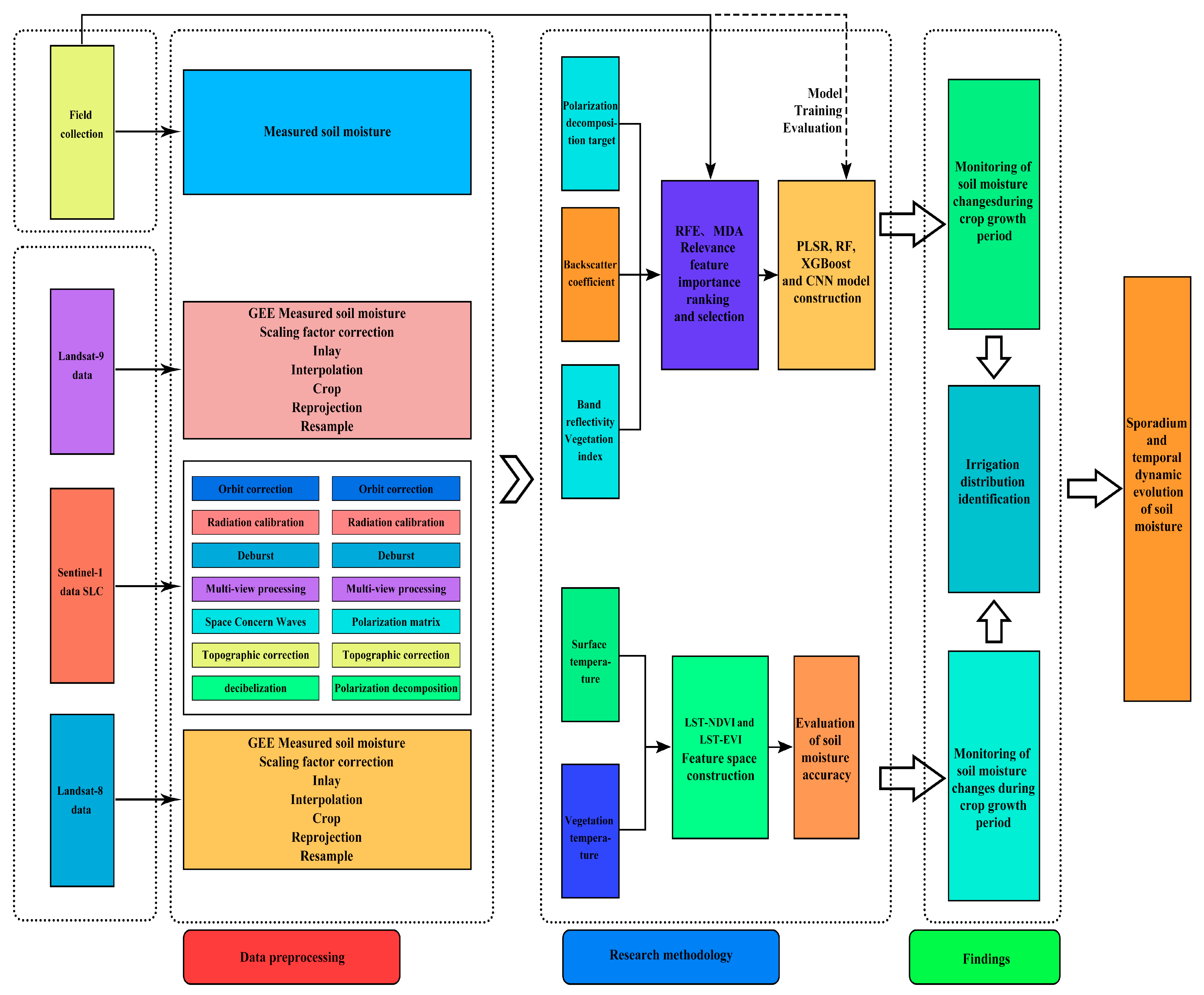
2.1. Technical Approach
2.2. Research Content
2.2.1. Spatiotemporal Dynamics of Soil Moisture During the Crop Growth Period (TVDI)
2.2.2. Soil Moisture Dynamics During Non-Growing Seasons Using Multi-Source Remote Sensing
2.2.3. Identification of Farmland Irrigation Distribution Across Spring, Growing, and Autumn Periods
2.3. Overview of the Study Area
2.3.1. Overview of the Hetao Irrigation District
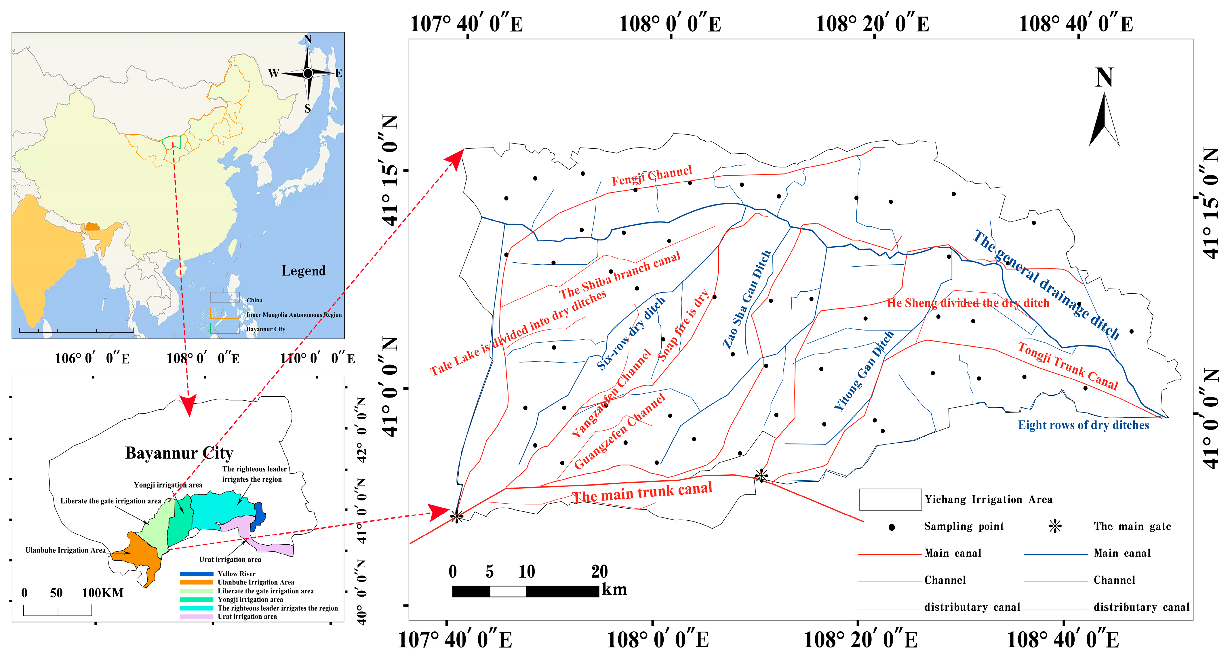
2.3.2. Overview of the Yichang Irrigation District
2.3.3. Irrigation and Drainage System Within the Yichang Irrigation District
2.3.4. Phenological Periods
2.4. Remote Sensing Data and Preprocessing
2.4.1. Landsat Data and Preprocessing
2.4.2. Sentinel-1 SAR Data and Preprocessing
2.4.3. Backward Scattering Coefficient
2.4.4. Polarization Modes
- Single-polarization: Uses one channel (e.g., HH or VV) to measure backscatter intensity for dielectric property inversion, offering simplified data processing.
- Dual-polarization: Combines H/V polarizations (e.g., HV-VH or VV-VH) to acquire multi-dimensional information like target direction, shape, and dielectric parameters.
- Full polarization: Transmits and receives across all H, V, and cross-polarization dimensions (+45°/−45°), capturing complete scattering matrix data for significantly improved 3D target feature reconstruction accuracy compared to dual-polarization systems.
2.4.5. Polarization Target Decomposition
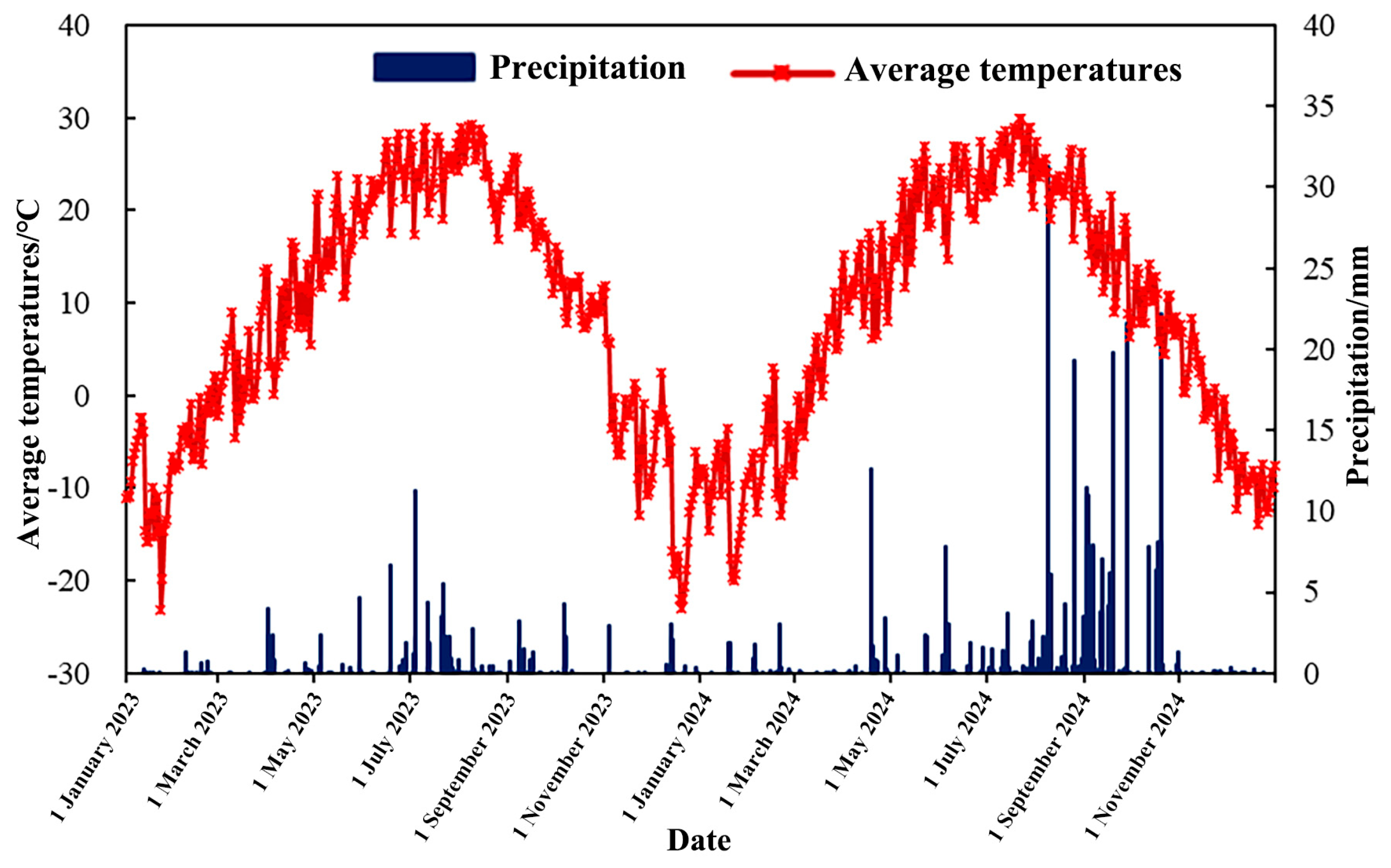
2.5. Meteorological Data
2.6. Agricultural Land Area Data for the Yichang Irrigation District
2.7. Model Construction and Evaluation
2.7.1. Partial Least Squares Regression Model
2.7.2. Random Forest Regression
2.7.3. Extreme Gradient Boosting
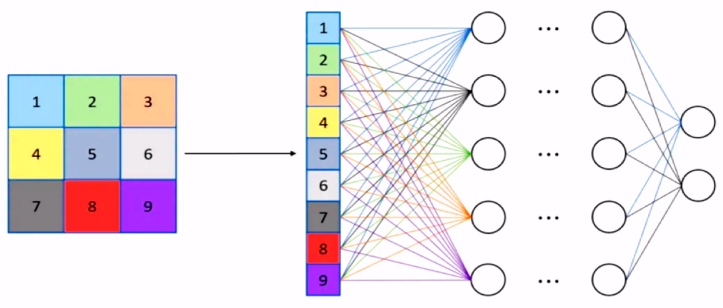
2.7.4. Convolutional Neural Networks
2.7.5. Model Evaluation Indicators
3. Results
3.1. Soil Moisture Inversion During the Crop Growing Season Based on TVDI
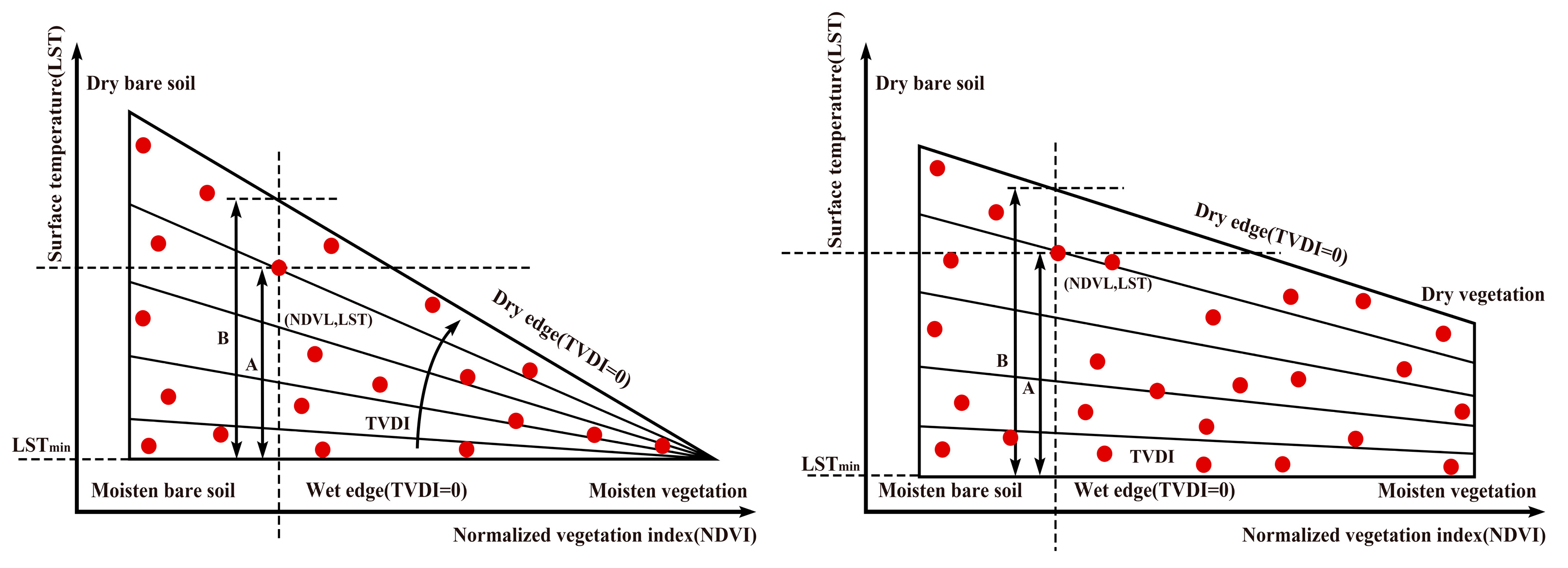
3.1.1. TVDI Principle
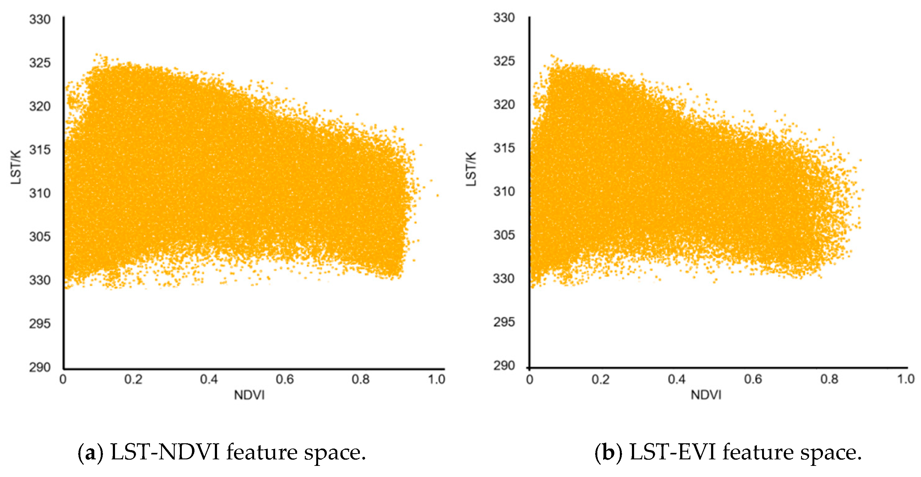
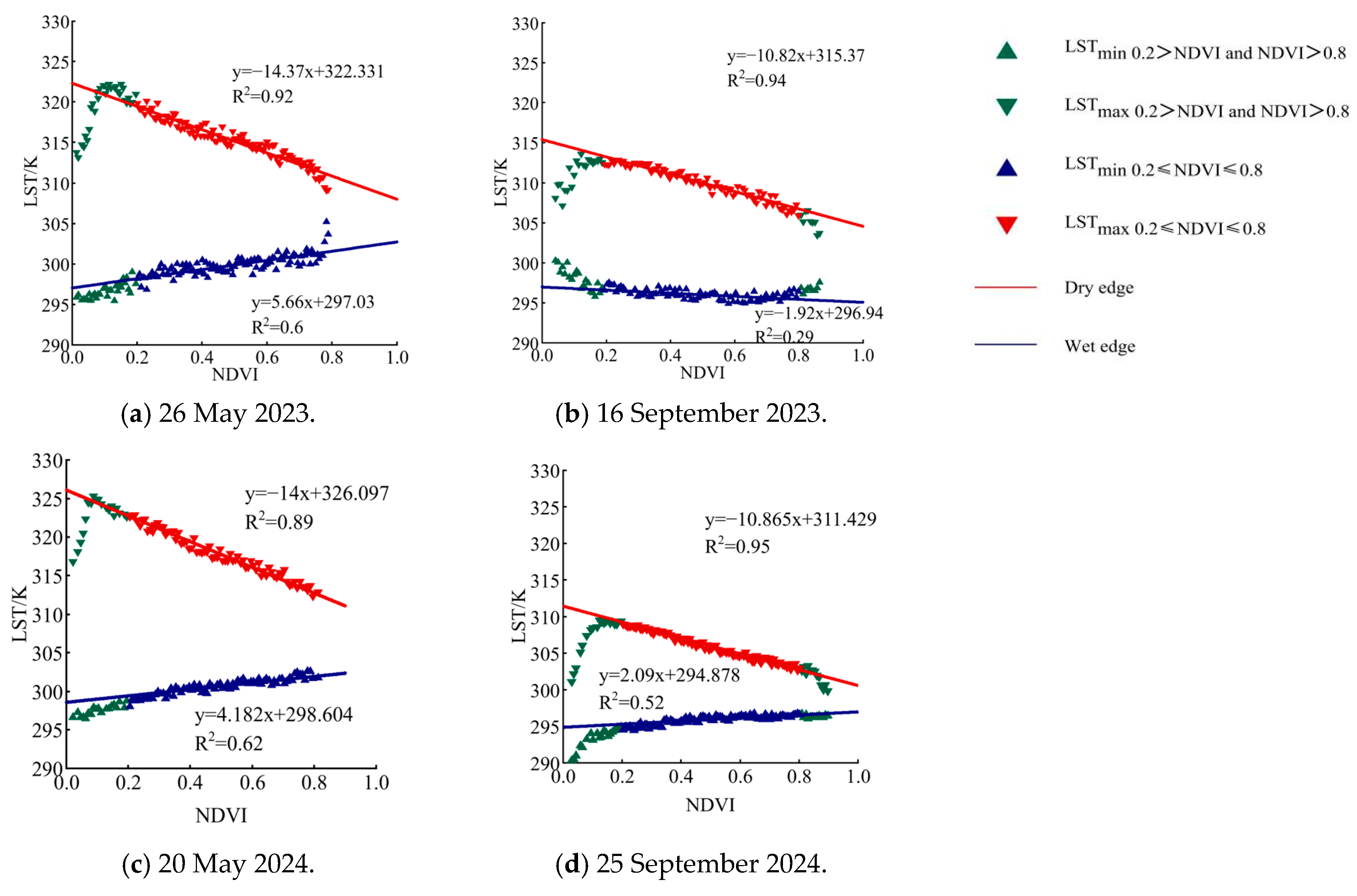
3.1.2. Construction of LST-NDVI Feature Space and Dry-Wet Boundary Fitting
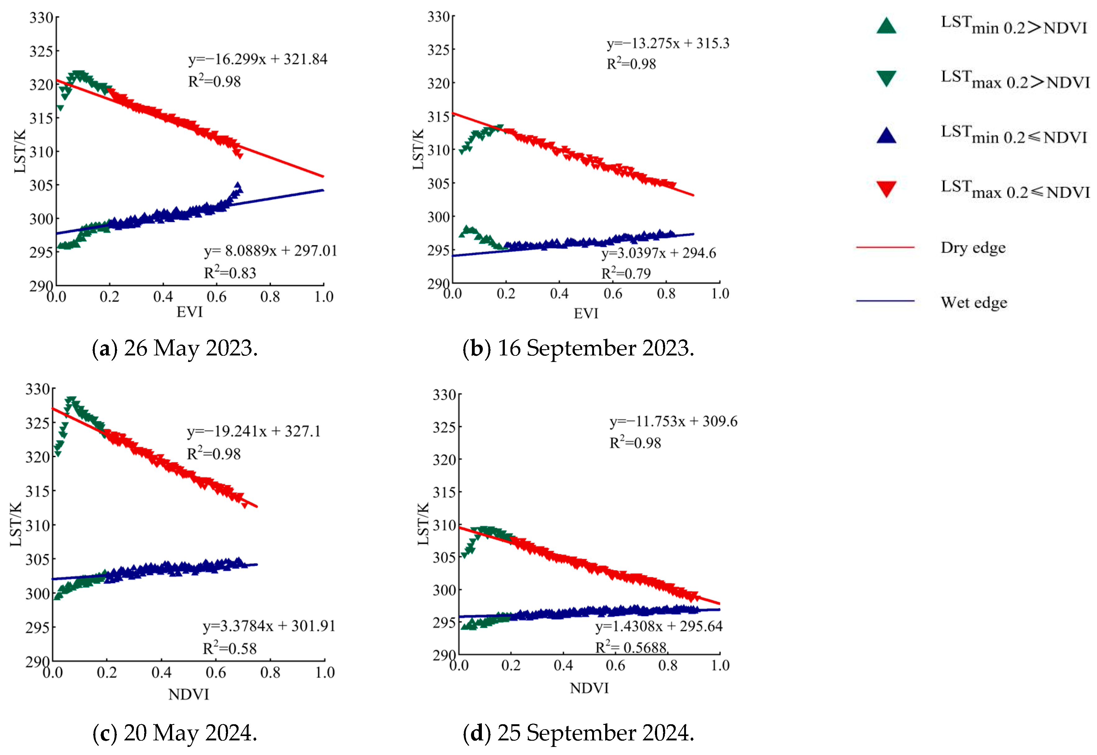
3.1.3. Construction of LST-EVI Feature Space and Dry–Wet Boundary Fitting
3.1.4. Comparison of Feature Factors in TVDI Feature Space
3.2. Inversion of Soil Moisture Spatiotemporal Distribution Based on TVDI
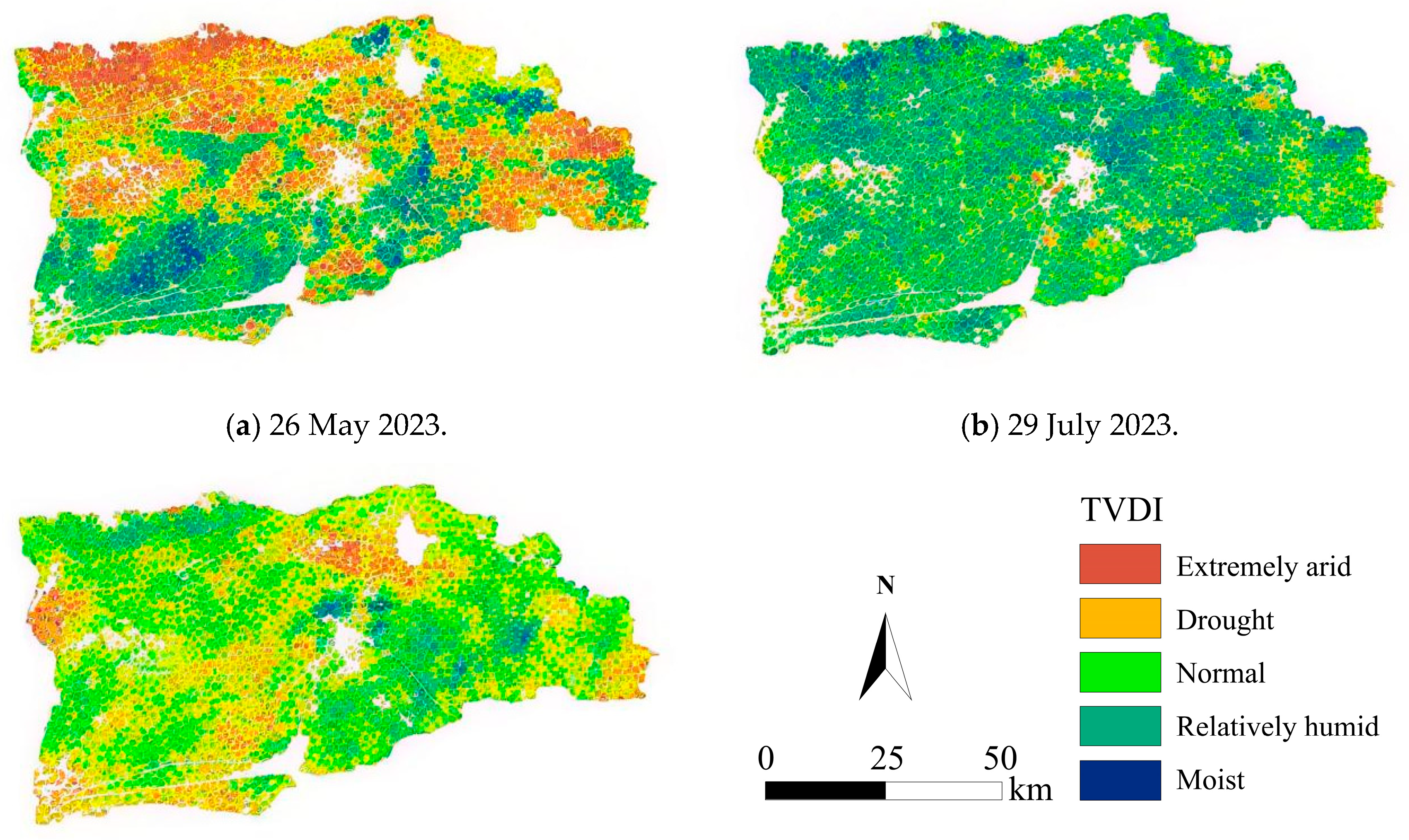
3.2.1. Soil Moisture Spatiotemporal Distribution Based on LST-NDVI Feature Space
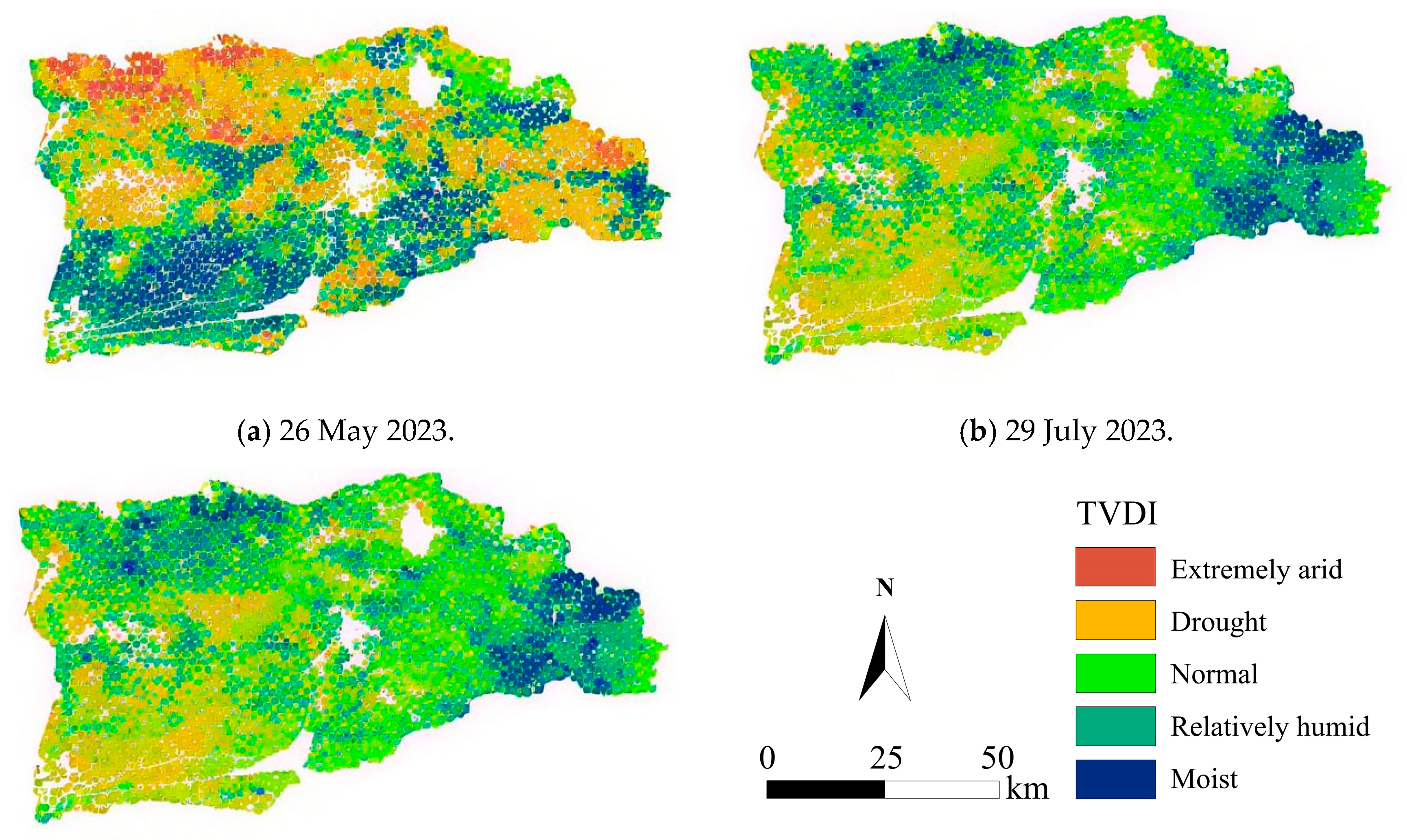
3.2.2. Spatiotemporal Distribution of Soil Moisture Based on the LST-EVI Feature Space
3.2.3. Accuracy Validation and Evaluation of the TVDI Model
3.3. Soil Moisture Inversion During the Crop Non-Growing Season (Spring Irrigation and Autumn Watering)
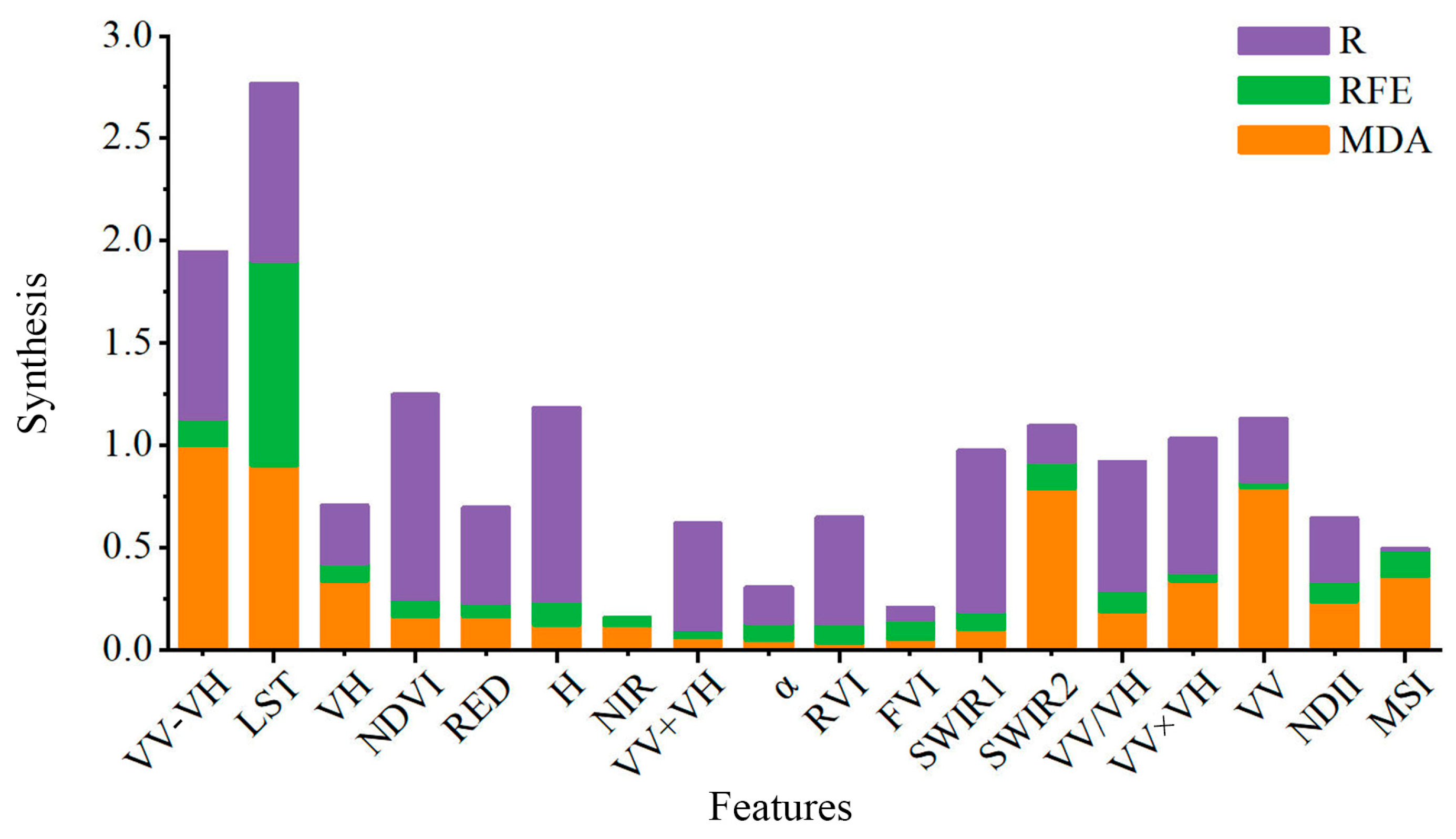
3.3.1. Feature Parameter Selection
- -
- LST scored highest.
- -
- Optical bands: SWIR exhibited the strongest sensitivity, followed by RED, then NIR.
- -
- Vegetation indices: NDVI > RVI > NDII > MSI > FVI.
- -
- Microwave: VV outperformed VH.
- -
- Combined features: VV − VH ranked 2nd; VV×VH and VV/VH were intermediate; VV + VH was lowest.
- -
- Polarization decomposition: entropy (H) ranked high, while the average scattering angle (α) was moderate.
3.3.2. Model Construction, Inversion, and Accuracy Verification
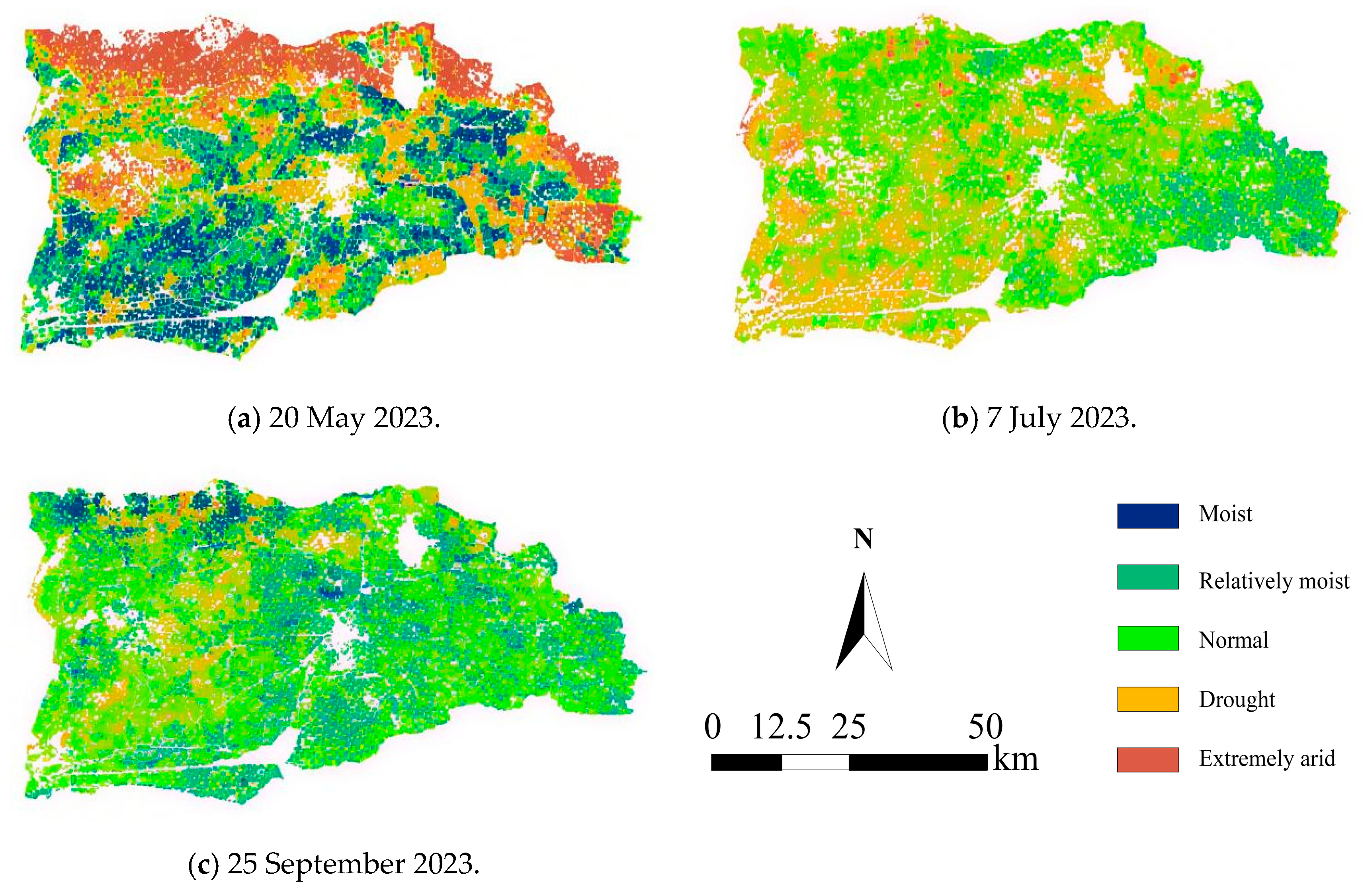
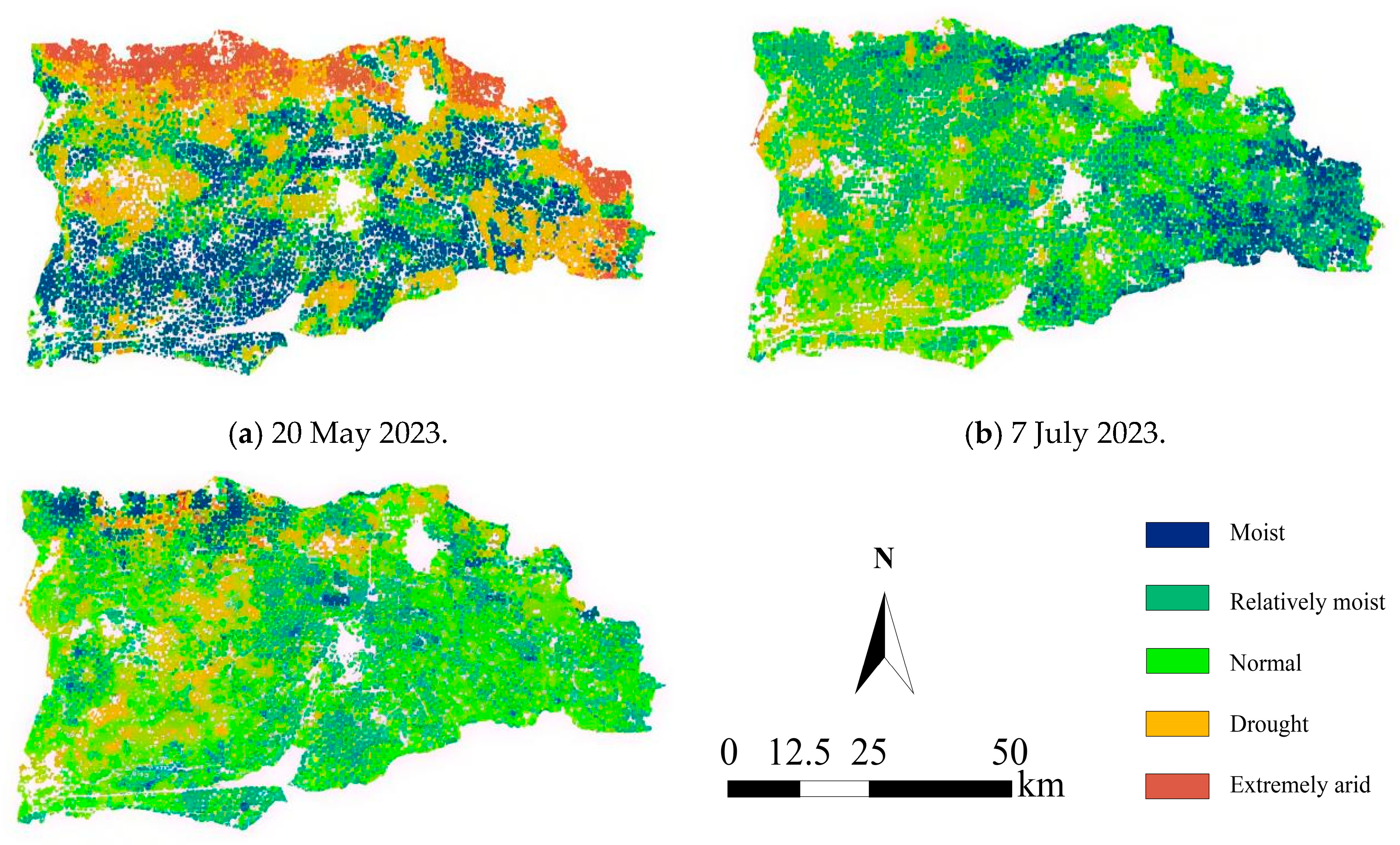
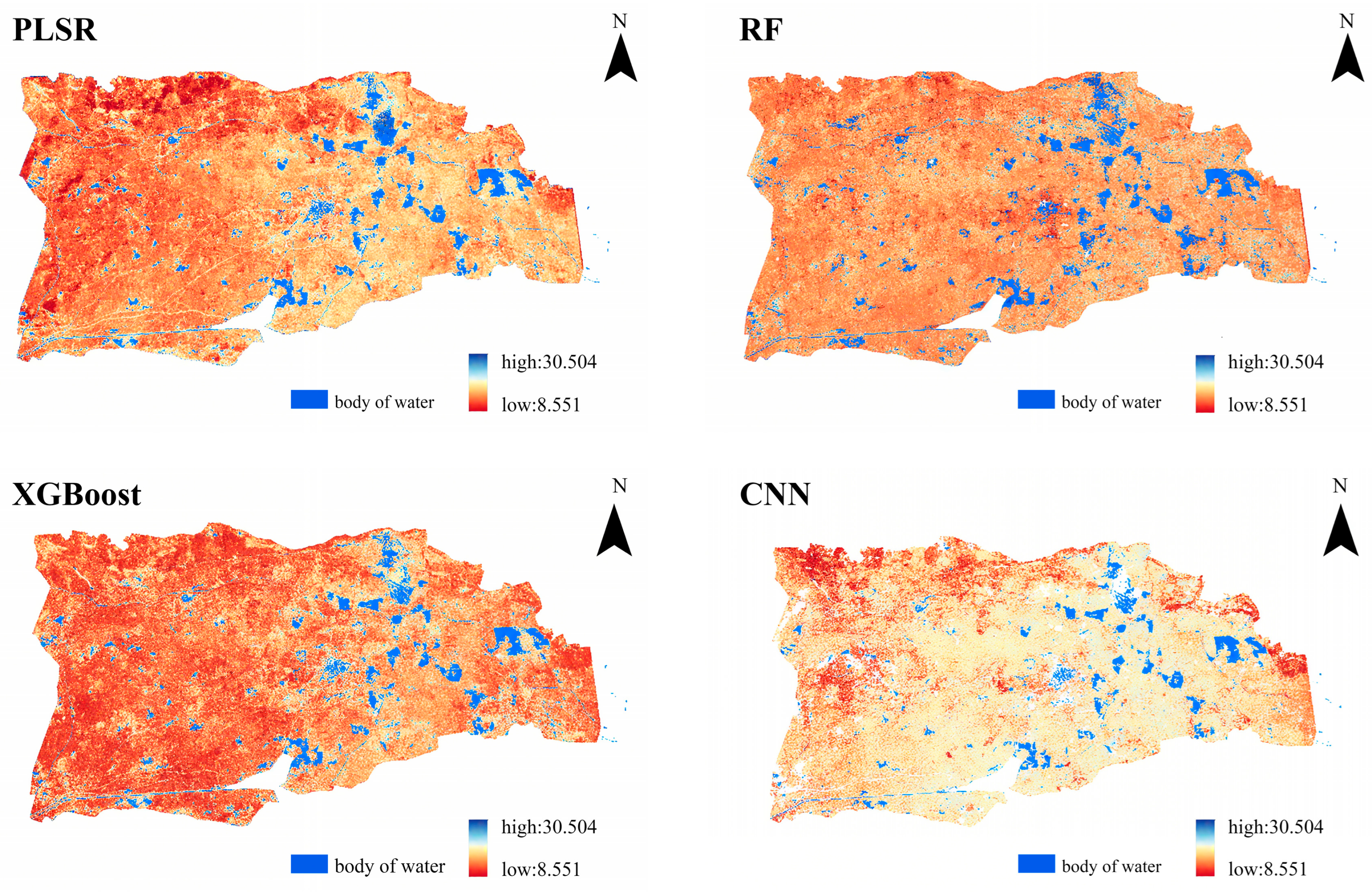
3.3.3. Spatial Distribution of Soil Moisture Based on CNN Model Inversion
3.4. Irrigation Distribution Identification and Soil Moisture Dynamic Evolution Analysis
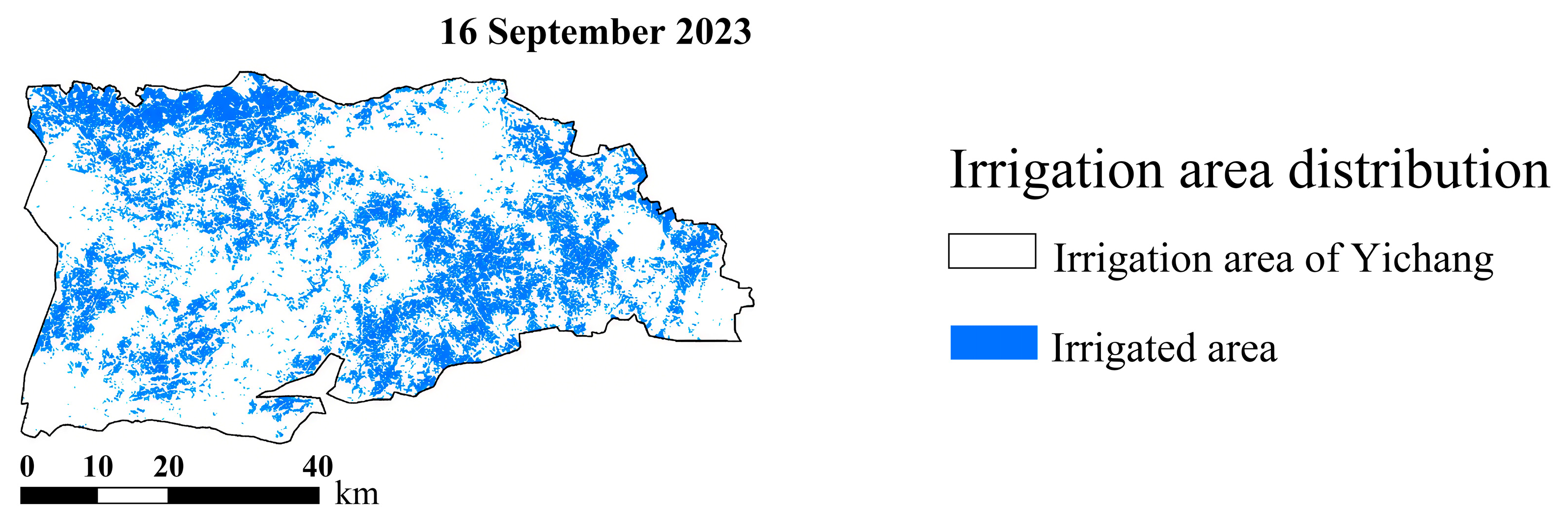
3.4.1. Identification of Irrigation Distribution During Crop Growth Periods
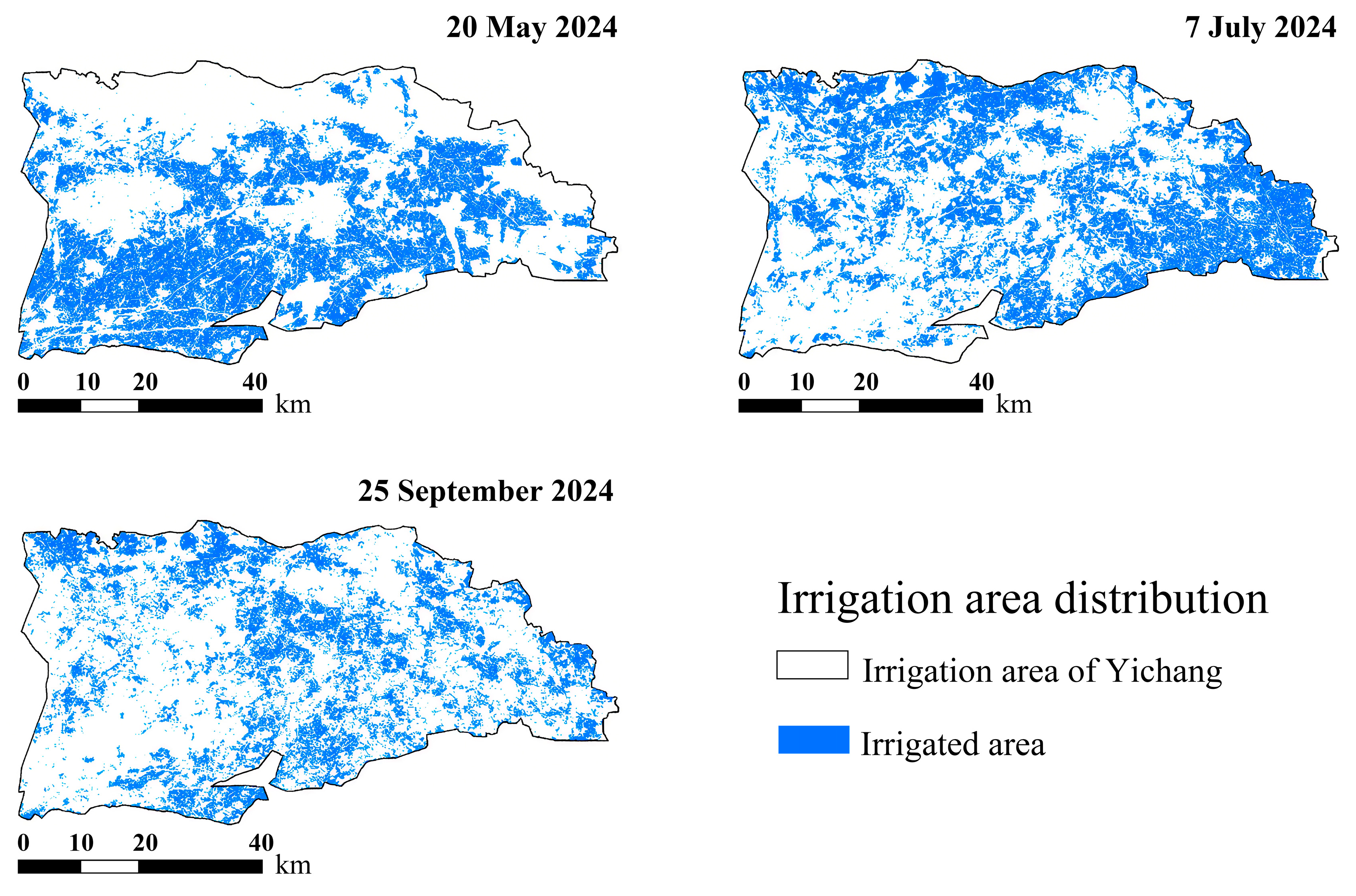
3.4.2. Identification of Irrigation Distribution During the Non-Growing Season of Crops
3.5. Analysis of the Dynamic Evolution of Irrigation in the Yichang Irrigation District
3.5.1. Irrigation Progress in the Yichang Irrigation Area
3.5.2. Comparison of Farmland Irrigation Area Identification Results with Statistical Data
3.5.3. Analysis of Dynamic Changes in the Irrigation Area
4. Discussion
4.1. Enhanced TVDI Accuracy via EVI: Mitigating NDVI Saturation
4.2. CNN-Driven Fusion of Multi-Source Features: Capturing Nonlinear Interactions
4.3. Spatial Complementarity of Irrigation: Pathways for Water Optimization
4.4. Limitations and Outlook
- (1)
- Adopt microwave–optical synergistic inversion by coupling Sentinel-1 SAR data (cloud-penetrating) with Landsat thermal bands, using spatiotemporal fusion models (e.g., improved AIEM) and rainfall correction factors to mitigate precipitation interference.
- (2)
- Deploy UAV multispectral/TIR sensors during critical growth stages to achieve 3 m resolution gap-filling, supplemented by high-frequency satellites (e.g., GF-1/6, PlanetScope) for 3–5 day revisits.
- (3)
- Ensure near-contemporaneous SAR–optical acquisitions. In this study, Sentinel-1 and Landsat scenes for the non-growing season were matched within ≤3 days (median ≈ 2 days), which did not introduce noticeable differences. Longer gaps can bias retrievals because soil moisture changes rapidly; future work should quantify the sensitivity of moisture estimates to time offsets and, when possible, keep SAR–optical pairs within 1–2 days or apply time-series fusion to correct larger offsets.
- (1)
- Implement dynamic zonal modeling by partitioning hydrological response units (HRUs) based on soil texture (clay/sand ratio), topography, and crop type, integrating covariates like surface roughness (SSR) to enhance robustness.
- (2)
- Expand feature engineering by incorporating MSAVI (to suppress bare soil noise) and FVC (to quantify canopy shading), fusing thermal indicators (e.g., diurnal temperature range (DTR) and canopy–air temperature difference (CATD)), and extracting phenophase-sensitive features (e.g., the EVI curve slope from Sentinel-2 time-series) to identify crop water-critical stages.
5. Conclusions
Author Contributions
Funding
Institutional Review Board Statement
Data Availability Statement
Conflicts of Interest
Abbreviations
| TVDI | Temperature–Vegetation Dryness Index |
| NDVI | Normalized Difference Vegetation Index |
| EVI | Enhanced Vegetation Index |
| MNDWI | Modified Normalized Difference Water Index |
| SAR | Synthetic Aperture Radar |
| PLSR | Partial Least Squares Regression |
| RF | Random Forest |
| XGBoost | Extreme Gradient Boosting |
| CNN | Convolutional Neural Network |
| GEE | Google Earth Engine |
| RFE | Recursive Feature Elimination |
| MDA | Mean Decrease Accuracy |
| VS | Versus |
References
- Sohrabinia, M.; Rack, W.; Zawar-Reza, P. Soil moisture derived using two apparent thermal inertia functions over Canterbury, New Zealand. J. Appl. Remote Sens. 2014, 8, 083624. [Google Scholar] [CrossRef][Green Version]
- He, L.; Qin, Q.; Panciera, R.; Tanase, M.; Walker, J.P.; Hong, Y. An Extension of the Alpha Approximation Method for Soil Moisture Estimation Using Time-Series SAR Data Over Bare Soil Surfaces. IEEE Geosci. Remote Sens. Lett. 2017, 14, 1328–1332. [Google Scholar] [CrossRef]
- Guan, H.; Huang, J.; Li, L.; Li, X.; Miao, S.; Su, W.; Ma, Y.; Niu, Q.; Huang, H. Improved Gaussian mixture model to map the flooded crops of VV and VH polarization data. Remote Sens. Environ. 2023, 295, 113714. [Google Scholar] [CrossRef]
- Zhang, H.; Wang, S.; Liu, K.; Li, X.; Li, Z.; Zhang, X.; Liu, B. Downscaling of AMSR-E Soil Moisture over North China Using Random Forest Regression. ISPRS Int. J. Geo Inf. 2022, 11, 101. [Google Scholar] [CrossRef]
- Weimann, A.; Von Schonermark, M.; Schumann, A.; Jorn, P.; Gunther, R. Soil moisture estimation with ERS-1 SAR data in the East-German loess soil area. Int. J. Remote Sens. 1998, 19, 237–243. [Google Scholar] [CrossRef]
- Liu, Z.; Li, P.; Yang, J. Soil Moisture Retrieval and Spatiotemporal Pattern Analysis Using Sentinel-1 Data of Dahra, Senegal. Remote Sensing. 2017, 9, 1197. [Google Scholar] [CrossRef]
- Santi, E.; Paloscia, S.; Pettinato, S.; Brocca, L.; Ciabatta, L.; Entekhabi, D. Integration of microwave data from SMAP and AMSR2 for soil moisture monitoring in Italy. Remote Sens. Environ. 2018, 212, 21–30. [Google Scholar] [CrossRef]
- Yang, Z.; Gong, J.; Wang, S.; Jin, T.; Wang, Y. Shifts bidirectional dependency between vegetation greening and soil moisture over the past four decades in China. Sci. Total Environ. 2023, 897, 166388. [Google Scholar] [CrossRef]
- Shahvaran, A.R.; Kheyrollah Pour, H.; Binding, C.; Van Cappellen, P. Mapping satellite-derived chlorophyll-a concentrations from 2013 to 2023 in Western Lake Ontario using Landsat 8 and 9 imagery. Sci. Total Environ. 2025, 968, 178881. [Google Scholar] [CrossRef]
- Wei, W.; Pang, S.; Wang, X.; Zhou, L.; Xie, B.; Zhou, J.; Li, C. Temperature Vegetation Precipitation Dryness Index (TVPDI)-based dryness-wetness monitoring in China. Remote Sens. Environ. 2020, 248, 111957. [Google Scholar] [CrossRef]
- Li, R.; Zhang, S.; Li, F.; Lin, X.; Luo, M.; Wang, S.; Yang, L.; Zhao, X. Impact of time-lagging and time-preceding environmental variables on top layer soil moisture in semiarid grasslands. Sci. Total Environ. 2024, 912, 169406. [Google Scholar] [CrossRef] [PubMed]
- Nugraha, A.S.A.; Kamal, M.; Murti, S.H.; Widyatmanti, W. Development of the triangle method for drought studies based on remote sensing images: A review. Remote Sens. Appl. Soc. Environ. 2023, 29, 100920. [Google Scholar] [CrossRef]
- Sandholt, I.; Rasmussen, K.; Andersen, J. A simple interpretation of the surface temperature/vegetation index space for assessment of surface moisture status. Remote Sens. Environ. 2002, 79, 213–224. [Google Scholar] [CrossRef]
- Tagesson, T.; Horion, S.; Nieto, H.; Zaldo Fornies, V.; Mendiguren González, G.; Bulgin, C.E.; Ghent, D.; Fensholt, R. Disaggregation of SMOS soil moisture over West Africa using the Temperature and Vegetation Dryness Index based on SEVIRI land surface parameters. Remote Sens. Environ. 2018, 206, 424–441. [Google Scholar] [CrossRef]
- Chen, J.; Wang, C.; Jiang, H.; Mao, L.; Yu, Z. Estimating soil moisture using Temperature–Vegetation Dryness Index (TVDI) in the Huang-huai-hai (HHH) plain. Int. J. Remote Sens. 2011, 32, 1165–1177. [Google Scholar] [CrossRef]
- Bai, J.-j.; Yu, Y.; Di, L. Comparison between TVDI and CWSI for drought monitoring in the Guanzhong Plain, China. J. Integr. Agric. 2017, 16, 389–397. [Google Scholar] [CrossRef]
- Lu, Z.; Shen, C.; Zhan, C.; Tang, H.; Luo, C.; Meng, S.; An, Y.; Wang, H.; Kou, X. Quantifying Multifactorial Drivers of Groundwater–Climate Interactions in an Arid Basin Based on Remote Sensing Data. Remote Sensing. 2025, 17, 2472. [Google Scholar] [CrossRef]
- Li, S.; Li, C.; Yao, D.; Wang, X.; Gao, Y. Bowl effect of irreversible primary salinization driven by geology in Hetao irrigation area, China. Sci. Total Environ. 2024, 920, 170834. [Google Scholar] [CrossRef] [PubMed]
- Xiang, Z.; Moriasi, D.N.; Samimi, M.; Mirchi, A.; Taghvaeian, S.; Steiner, J.L.; Verser, J.A.; Starks, P.J. SWAT-IRR: A new irrigation algorithm for soil and water Assessment tool to facilitate water management and Conservation in irrigated regions. Comput. Electron. Agric. 2025, 232, 110142. [Google Scholar] [CrossRef]
- Zhao, Y.; Yang, S.; Shi, H.; Han, H.; Dong, Y.; Li, X.; Yan, J.; Yan, Y.; Dou, X.; Tian, F.; et al. Analysis of soil salinization and land use change under water conservation retrofit in the Hetao irrigation district. Smart Agric. Technol. 2025, 12, 101143. [Google Scholar] [CrossRef]
- Huang, F.; Chunyu, X.; Zhang, D.; Chen, X.; Ochoa, C.G. A framework to assess the impact of ecological water conveyance on groundwater-dependent terrestrial ecosystems in arid inland river basins. Sci. Total Environ. 2020, 709, 136155. [Google Scholar] [CrossRef]
- Zhao, Y.; Miao, Q.; Shi, H.; Li, X.; Yan, J.; Yang, S.; Hou, C.; Yu, C.; Feng, W.; Hao, J. Inversion of soil salinization at the branch canal scale in the Hetao Irrigation District based on improved spectral indices. Agric. Water Manag. 2025, 316, 109608. [Google Scholar] [CrossRef]
- Li, J.; He, P.; Chen, J.; Hamad, A.A.A.; Dai, X.; Jin, Q.; Ding, S. Tomato performance and changes in soil chemistry in response to salinity and Na/Ca ratio of irrigation water. Agric. Water Manag. 2023, 285, 108363. [Google Scholar] [CrossRef]
- Miao, Q.; Rosa, R.D.; Shi, H.; Paredes, P.; Zhu, L.; Dai, J.; Gonçalves, J.M.; Pereira, L.S. Modeling water use, transpiration and soil evaporation of spring wheat–maize and spring wheat–sunflower relay intercropping using the dual crop coefficient approach. Agric. Water Manag. 2016, 165, 211–229. [Google Scholar] [CrossRef]
- Feng, Z.; Miao, Q.; Shi, H.; Li, X.; Yan, J.; Gonçalves, J.M.; Dai, L.; Feng, W. Irrigation scheduling in sand-layered farmland: Evaluation of water and salinity dynamics in the soil by SALTMED-1D model under mulched maize production in Hetao Irrigation District, China. Eur. J. Agron. 2024, 157, 127177. [Google Scholar] [CrossRef]
- Altuwaijri, H.A.; Al Kafy, A.; Rahaman, Z.A.; Fariha, J.N.; Miah, M.T.; Mishu, R.A.; Nath, H.; Sonet, M.S. Biophysical parameters and land surface temperature dynamics in arid urban environments: A comprehensive machine learning approach. Environ. Earth Sci. 2025, 84, 434. [Google Scholar] [CrossRef]
- Echavarría-Caballero, C.; Domínguez-Gómez, J.A.; González-García, C.; Domínguez-Perez, R.; García-García, M.J. Warming inland water in peninsular Spain revealed by landsat 5 analysis. Geocarto Int. 2024, 39, 2371923. [Google Scholar] [CrossRef]
- Imroah, F.F.K.; Setiawan, N. Integration of Landsat-8 OLI/TIRS and Sentinel-1A PolSAR for analyzing land surface temperature and its anomalies linked to ENSO in Surakarta, Indonesia. Geomatica 2024, 76, 100038. [Google Scholar] [CrossRef]
- Portela, B.; van der Werff, H.; Hecker, C.; van der Meijde, M. Landsat Next current design for geological remote sensing: VNIR-SWIR-TIR data continuity and new opportunities. Sci. Remote Sens. 2025, 12, 100258. [Google Scholar] [CrossRef]
- Cui, Y.; Chen, S.; Mo, G.; Ji, D.; Lv, L.; Fu, J. Snow Depth Retrieval Using Sentinel-1 Radar Data: A Comparative Analysis of Random Forest and Support Vector Machine Models with Simulated Annealing Optimization. Remote Sensing. 2025, 17, 2584. [Google Scholar] [CrossRef]
- Numbisi, F.N. Minding Spatial Allocation Entropy: Sentinel-2 Dense Time Series Spectral Features Outperform Vegetation Indices to Map Desert Plant Assemblages. Remote Sens. 2025, 17, 2553. [Google Scholar] [CrossRef]
- Mateus, P.; Nico, G.; Catalão, J.; Miranda, P.M.A. Precipitable water vapor from Sentinel-1 improves the forecast of extratropical storm Barbara. Q. J. R. Meteorol. Soc. 2024, 150, 1988–2004. [Google Scholar] [CrossRef]
- He, Y.; Yin, H.; Chen, Y.; Xiang, R.; Zhang, Z.; Chen, H. Soil Salinity Estimation Based on Sentinel-1/2 Texture Features and Machine Learning. IEEE Sens. J. 2024, 24, 15302–15310. [Google Scholar] [CrossRef]
- Freeman, A.; Durden, S.L. A three-component scattering model for polarimetric SAR data. IEEE Trans. Geosci. Remote Sens. 1998, 36, 963–973. [Google Scholar] [CrossRef]
- Cloude, S.R.; Pottier, E. An entropy based classification scheme for land applications of polarimetric SAR. IEEE Trans. Geosci. Remote Sens. 1997, 35, 68–78. [Google Scholar] [CrossRef]
- Fayyaz, A.; Waqas, M.; Asghar, H.; Ahmed, R.; Liaqat, U.; Naseem, K.; Baig, M.A. Rapid elemental imaging of copper-bearing critical ores using laser-induced breakdown spectroscopy coupled with PCA and PLS-DA. Talanta 2026, 296, 128463. [Google Scholar] [CrossRef]
- Breiman, L. Random Forests. Mach. Learn. 2001, 45, 5–32. [Google Scholar] [CrossRef]
- Chen, T.; Guestrin, C. XGBoost: A Scalable Tree Boosting System. In Proceedings of the 22nd ACM SIGKDD International Conference on Knowledge Discovery and Data Mining, San Francisco, CA, USA, 13–17 August 2016; pp. 785–794. [Google Scholar]
- Zhang, T.; Shen, X.; Cao, L. Terrain and individual tree vertical structure-based approach for point clouds co-registration by UAV and Backpack LiDAR. Int. J. Appl. Earth Obs. Geoinf. 2025, 139, 104544. [Google Scholar] [CrossRef]
- Miao, J.; Wang, J.; Zhao, D.; Shen, Z.; Xiang, H.; Gao, C.; Li, W.; Cui, L.; Wu, G. Modeling strategies and influencing factors in retrieving canopy equivalent water thickness of mangrove forest with Sentinel-2 image. Ecol. Indic. 2024, 158, 111497. [Google Scholar] [CrossRef]
- Rawat, K.S.; Sehgal, V.K.; Singh, S.K.; Ray, S.S. Soil moisture estimation using triangular method at higher resolution from MODIS products. Phys. Chem. Earth Parts A/B/C 2022, 126, 103051. [Google Scholar] [CrossRef]
- Lu, Y.; Tao, H.; Wu, H. Dynamic Drought Monitoring in Guangxi Using Revised Temperature Vegetation Dryness Index. Wuhan Univ. J. Nat. Sci. 2007, 12, 663–668. [Google Scholar] [CrossRef]
- Tucker, C.J. Red and photographic infrared linear combinations for monitoring vegetation. Remote Sens. Environ. 1979, 8, 127–150. [Google Scholar] [CrossRef]
- Carlson, T.N.; Ripley, D.A. On the relation between NDVI, fractional vegetation cover, and leaf area index. Remote Sens. Environ. 1997, 62, 241–252. [Google Scholar] [CrossRef]
- Huete, A.; Didan, K.; Miura, T.; Rodriguez, E.P.; Gao, X.; Ferreira, L.G. Overview of the radiometric and biophysical performance of the MODIS vegetation indices. Remote Sens. Environ. 2002, 83, 195–213. [Google Scholar] [CrossRef]
- Jiang, Z.; Huete, A.R.; Didan, K.; Miura, T. Development of a two-band enhanced vegetation index without a blue band. Remote Sens. Environ. 2008, 112, 3833–3845. [Google Scholar] [CrossRef]
- Jiang, L.; Islam, S. Estimation of surface evaporation map over Southern Great Plains using remote sensing data. Water Resources Research. 2001, 37, 329–340. [Google Scholar] [CrossRef]
- Nemani, R.R.; Running, S.W. Estimation of Regional Surface Resistance to Evapotranspiration from NDVI and Thermal-IR AVHRR Data. J. Appl. Meteorol. Climatol. 1989, 28, 276–284. [Google Scholar] [CrossRef]
- Price, J.C. Using spatial context in satellite data to infer regional scale evapotranspiration. IEEE Trans. Geosci. Remote Sens. 1990, 28, 940–948. [Google Scholar] [CrossRef]
- Cheng, Z.; Gu, X.; Zhang, Z.; Xu, Y.; Zhao, T.; Li, Y.; Sun, S.; Du, Y.; Cai, H. TAM-Net: A deep network combining tabular diffusion algorithm, attention mechanism, and multi-task learning for monitoring crop water status from UAV multi-source images. Eur. J. Agron. 2025, 170, 127778. [Google Scholar] [CrossRef]
- Chen, Z.; Huang, W.; Ye, S.; Qi, X. Analysis of Differences in Agricultural Drought Monitoring in Fujian Province in 2018 Based on Different TVDI Indices. J. Nat. Disasters 2021, 30, 233–243. [Google Scholar] [CrossRef]
- Zhou, S.; Williams, A.P.; Lintner, B.R.; Berg, A.M.; Zhang, Y.; Keenan, T.F.; Cook, B.I.; Hagemann, S.; Seneviratne, S.I.; Gentine, P. Soil moisture–atmosphere feedbacks mitigate declining water availability in drylands. Nat. Clim. Change 2021, 11, 38–44. [Google Scholar] [CrossRef]
- Chen, X.; Ding, Y.; Zheng, X.; Xu, C.; Wu, Z.; Xie, Q. Improved estimation of non-photosynthetic vegetation cover using a novel multispectral slope difference index with soil information, Sentinel-1 data, and machine learning. Ecol. Inform. 2024, 84, 102930. [Google Scholar] [CrossRef]
- Abowarda, A.S.; Bai, L.; Zhang, C.; Long, D.; Li, X.; Huang, Q.; Sun, Z. Generating surface soil moisture at 30 m spatial resolution using both data fusion and machine learning toward better water resources management at the field scale. Remote Sens. Environ. 2021, 255, 112301. [Google Scholar] [CrossRef]
- Fu, D.; Jin, X.; Jin, Y.; Mao, X. Extraction of grassland irrigation information in arid regions based on multi-source remote sensing data. Agric. Water Manag. 2024, 302, 109010. [Google Scholar] [CrossRef]
- Liu, Y.; Wu, W.; Li, Z.; Zhou, Q. Extracting irrigated cropland spatial distribution in China based on time-series NDVI. Trans. Chin. Soc. Agric. Eng. 2017, 33, 276–284. [Google Scholar] [CrossRef]
- Food and Agriculture Organization. The State of the World’s Land and Water Resources for Food and Agriculture—Systems at Breaking Point; Food and Agriculture Organization: Rome, Italy, 2021. [Google Scholar]




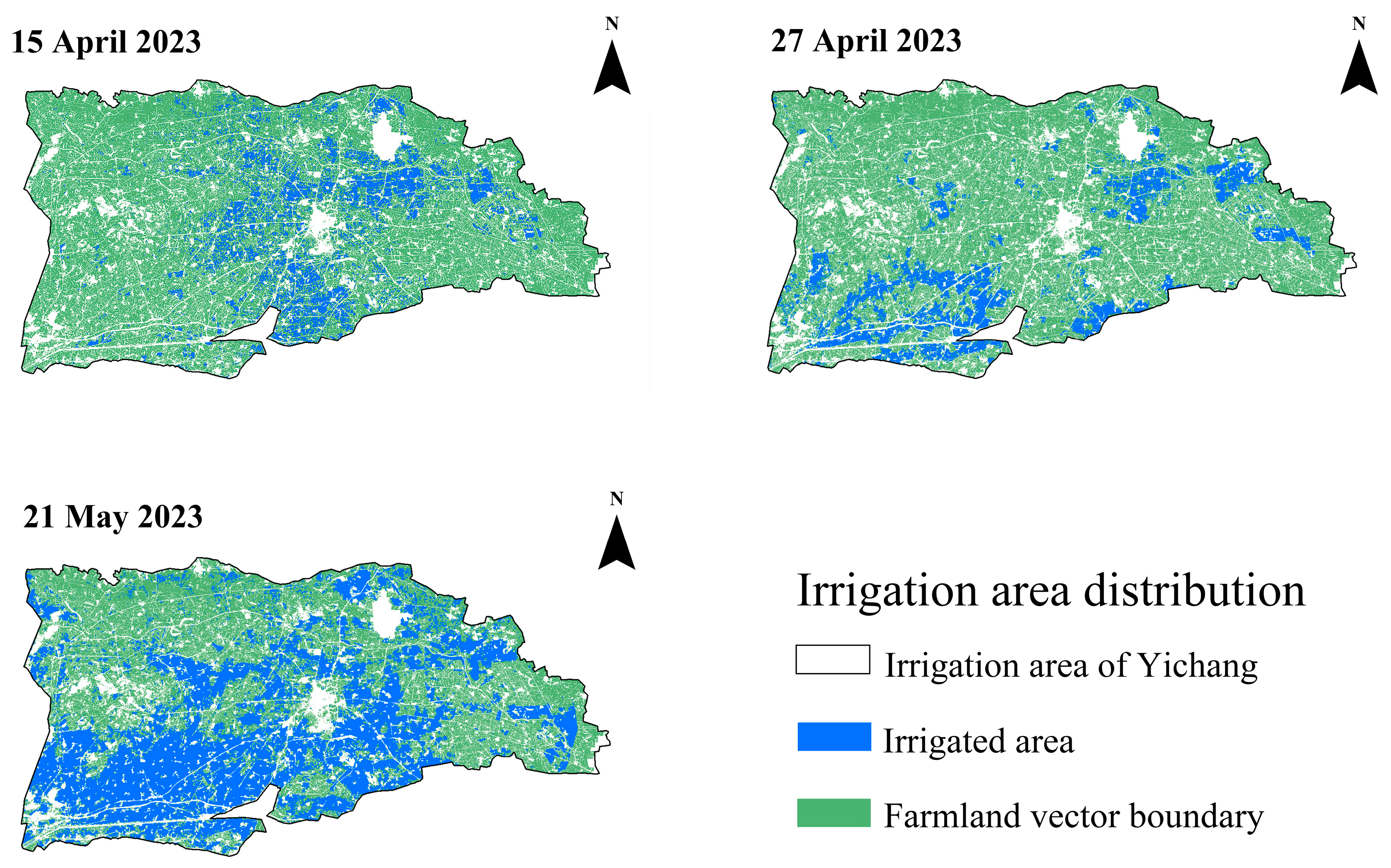
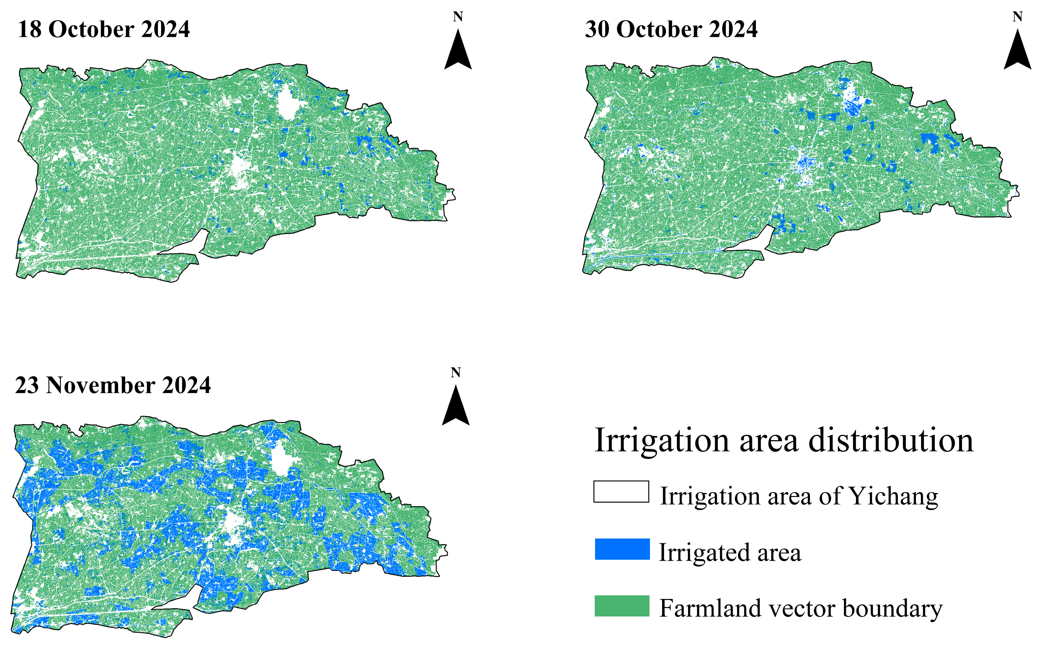
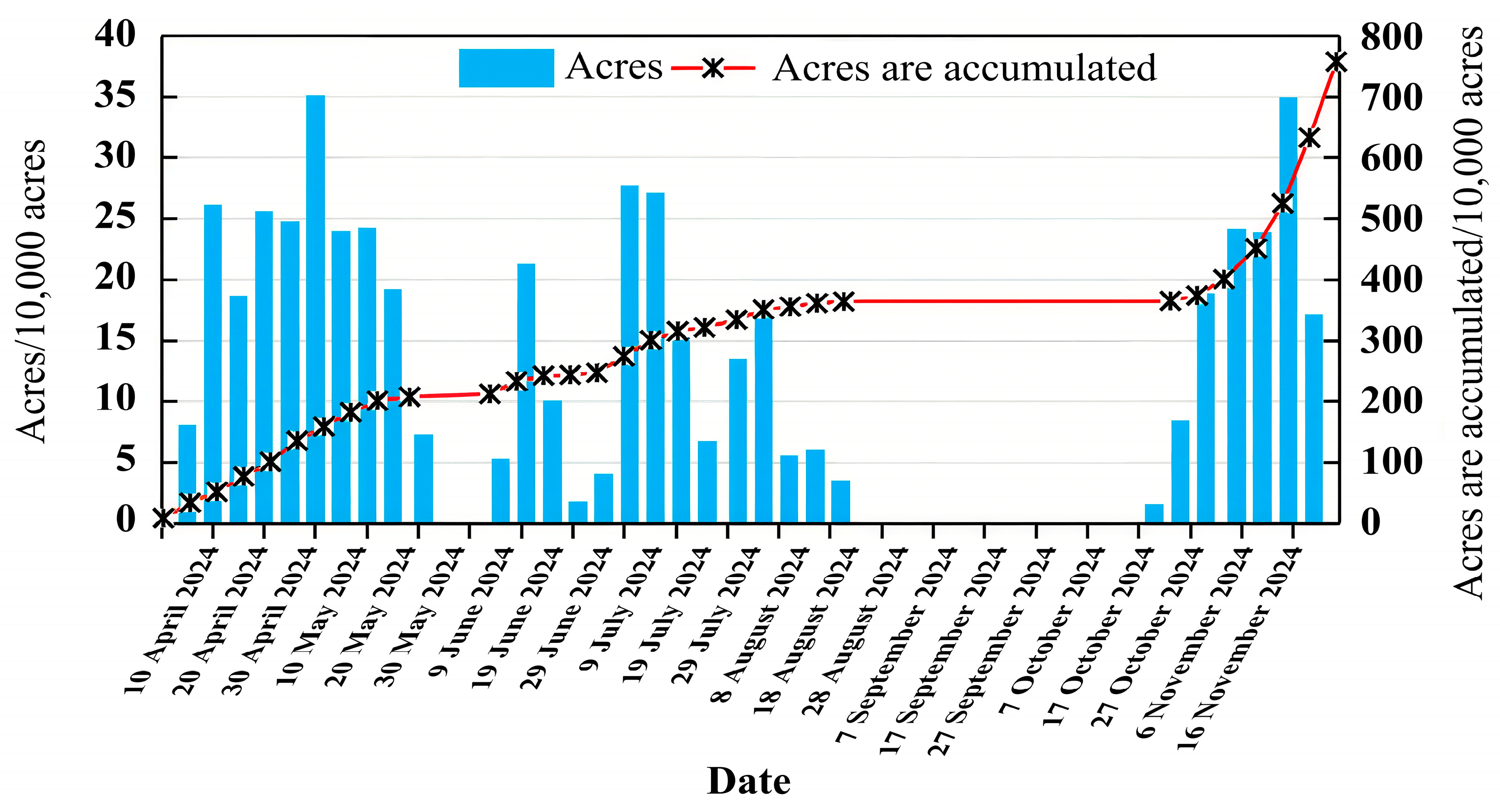

| Crop | Wheat | Corn | Sunflower | Zucchini | |
|---|---|---|---|---|---|
| April | Early | Sowing | |||
| Mid- | |||||
| Late | Germination | Sowing | |||
| May | Early | Tillering | Sowing | Sowing | |
| Mid- | Germination | Germination | |||
| Late | Stem elongation | Sowing | |||
| June | Early | Sowing | First bloom | ||
| Mid- | Spike formation | First bloom | |||
| Late | Spike emergence | Stem elongation | Germination | Fruiting | |
| July | Early | Milk stage | Fruiting | ||
| Mid- | Silking | ||||
| Late | Maturity | Silking | Budding | ||
| August | Early | Blooming | |||
| Mid- | Blooming | Maturity | |||
| Late | Milk stage | ||||
| September | Early | ||||
| Mid- | |||||
| Late | Maturity | Maturity | |||
| October | Early | Maturity |
| Name | Band Name | Band (μm) | Spatial Resolution |
|---|---|---|---|
| SR_B1 | Ultra-Blue | 0.435–0.451 | 30 |
| SR_B2 | Blue | 0.452–0.512 | 30 |
| SR_B3 | Green | 0.533–0.590 | 30 |
| SR_B4 | Red | 0.636–0.673 | 30 |
| SR_B5 | Near-Infrared | 0.851–0.879 | 30 |
| SR_B6 | Shortwave Infrared 1 | 1.566–1.651 | 30 |
| SR_B7 | Shortwave Infrared 2 | 2.107–2.294 | 30 |
| ST_B10 | Surface Temperature | 10.60–11.19 | 100 |
| Mode | Incidence Angle (°) | Resolution (m) | Swath Width (km) | Polarization Mode |
|---|---|---|---|---|
| Strip imaging (SM) | 20–45 | 5 × 5 | 80 | Single, dual polarization |
| Interferometric wide swath (IW) | 29–45 | 5 × 20 | 250 | Single, dual polarization |
| Ultra-wide swath (EW) | 19–47/22–35 | 20 × 40 | 400 | Single, dual polarization |
| Wave (Wave) | 35–38 | 5 × 5 | 20 × 20 | Single polarization |
| Time | Model | Training Set | Test Set | ||||
|---|---|---|---|---|---|---|---|
| R2 | RMSE (%) | MAE (%) | R2 | RMSE (%) | MAE (%) | ||
| April | PLSR | 0.48 | 3.47 | 2.49 | 0.44 | 3.954 | 3.281 |
| RF | 0.57 | 2.56 | 1.91 | 0.53 | 3.08 | 2.48 | |
| XGBoost | 0.61 | 2.31 | 1.71 | 0.59 | 2.63 | 1.86 | |
| CNN | 0.67 | 2.30 | 1.46 | 0.61 | 2.85 | 2.22 | |
| October | PLSR | 0.45 | 3.66 | 2.86 | 0.41 | 3.93 | 3.42 |
| RF | 0.52 | 3.45 | 2.71 | 0.51 | 3.44 | 2.98 | |
| XGBoost | 0.56 | 3.12 | 2.63 | 0.52 | 3.02 | 2.75 | |
| CNN | 0.61 | 2.51 | 2.43 | 0.56 | 2.64 | 2.66 | |
| 2023 | Irrigated Area (10,000 ha) | Area Ratio (%) | 2024 | Irrigated Area (10,000 ha) | Area Proportion (%) |
|---|---|---|---|---|---|
| 26 May | 10.54 | 36.03 | 20 May | 12.70 | 43.39 |
| 3 June | 10.11 | 34.58 | 13 June | 4.84 | 16.53 |
| 11 June | 7.21 | 24.63 | 21 June | 0.97 | 3.31 |
| 5 July | 10.53 | 36.00 | 7 July | 13.43 | 45.88 |
| 22 August | 20.42 | 69.79 | 16 August | 20.99 | 71.42 |
| 16 September | 10.67 | 36.47 | 25 September | 9.45 | 32.29 |
| 2023 | Irrigated Area (10,000 ha) | Area Ratio (%) | 2024 | Irrigated Area (10,000 mha) | Area Proportion (%) |
|---|---|---|---|---|---|
| 15 April | 3.95 | 13.44 | 18 October | 0.77 | 2.61 |
| 27 April | 3.62 | 12.36 | 30 October | 1.91 | 6.53 |
| 21 May | 12.21 | 41.74 | 23 November | 7.18 | 24.55 |
| Date | Identified Area/Million Acres | Cumulative Area/Million Acres | Accuracy (%) |
|---|---|---|---|
| 20 May 2024 | 190.34 | 181.59 | 95.40 |
| 16 August 2024 | 313.29 | 360.49 | 86.91 |
| 23 November 2024 | 107.70 | 124.71 | 86.36 |
Disclaimer/Publisher’s Note: The statements, opinions and data contained in all publications are solely those of the individual author(s) and contributor(s) and not of MDPI and/or the editor(s). MDPI and/or the editor(s) disclaim responsibility for any injury to people or property resulting from any ideas, methods, instructions or products referred to in the content. |
© 2025 by the authors. Licensee MDPI, Basel, Switzerland. This article is an open access article distributed under the terms and conditions of the Creative Commons Attribution (CC BY) license (https://creativecommons.org/licenses/by/4.0/).
Share and Cite
Sun, Y.; Zhang, D.; Miao, Z.; Yang, S.; Liu, Q.; Qu, Z. Season-Specific CNN and TVDI Approach for Soil Moisture and Irrigation Monitoring in the Hetao Irrigation District, China. Agriculture 2025, 15, 1946. https://doi.org/10.3390/agriculture15181946
Sun Y, Zhang D, Miao Z, Yang S, Liu Q, Qu Z. Season-Specific CNN and TVDI Approach for Soil Moisture and Irrigation Monitoring in the Hetao Irrigation District, China. Agriculture. 2025; 15(18):1946. https://doi.org/10.3390/agriculture15181946
Chicago/Turabian StyleSun, Yule, Dongliang Zhang, Ze Miao, Shaodong Yang, Quanming Liu, and Zhongyi Qu. 2025. "Season-Specific CNN and TVDI Approach for Soil Moisture and Irrigation Monitoring in the Hetao Irrigation District, China" Agriculture 15, no. 18: 1946. https://doi.org/10.3390/agriculture15181946
APA StyleSun, Y., Zhang, D., Miao, Z., Yang, S., Liu, Q., & Qu, Z. (2025). Season-Specific CNN and TVDI Approach for Soil Moisture and Irrigation Monitoring in the Hetao Irrigation District, China. Agriculture, 15(18), 1946. https://doi.org/10.3390/agriculture15181946


