Article

Evaluating Carbon Sink Responses to Multi-Scenario Land Use Changes in the Dianchi Lake Basin: An Integrated PLUS-InVEST Model Approach

1
Faculty of Geography, Yunnan Normal University, Kunming 650500, China
2
GIS Technology Engineering Research Centre for West-China Resources and Environment of Educational Ministry, Kunming 650500, China
*
Author to whom correspondence should be addressed.
Agriculture 2025, 15(12), 1286; https://doi.org/10.3390/agriculture15121286
Submission received: 10 May 2025 / Revised: 5 June 2025 / Accepted: 11 June 2025 / Published: 14 June 2025
(This article belongs to the Section Digital Agriculture)

Abstract

:
Land use and land cover changes are critical drivers of terrestrial carbon stock dynamics, as they alter native vegetation and land-based production activities. Scenario-based simulation of land use and carbon stock evolution offer valuable insights into the carbon sink potential of different development strategies and support low-carbon land planning. We focus on the Dianchi Basin, integrating a Markov-PLUS land use simulation with the InVEST carbon assessment model to examine carbon stock changes from 2000 to 2030 under three scenarios: natural development and cropland and ecological protections. Results indicate that from 2000 to 2020, the region experienced significant urbanization, with cropland decreasing and forest land expanding. Forests contributed the most to the total carbon storage, followed by cropland. The total carbon stock initially increased but experienced a marked decline from 2010 to 2020, aa trend expected to continue, largely attributable to the transformation of cropland and grassland into construction land, as well as the conversion of forest into cropland. By 2030, carbon stock trajectories would vary across scenarios. Both the natural development and cropland protection scenarios resulted in carbon loss, whereas the ecological protection scenario increased carbon storage and reversed the declining trend. Spatially, carbon stock distribution in the basin exhibits strong heterogeneity, with higher values in the periphery and lower values in the urban center. We reveal the spatio-temporal characteristics of carbon stock change and the carbon consequences of land use policies, providing scientific evidence to support land use restructuring, carbon sink enhancement, and regional carbon emission reduction under the dual-carbon goals of China.

1. Introduction

Land use change (LUC) profoundly affects carbon cycle processes in terrestrial ecosystems [1], serving both as a driver and outcome of climate change. The intensification of human activities, especially urbanization, agricultural expansion, and infrastructure growth, resulted in substantial changes in land use structures [2], thereby disrupting the structure and function of natural ecosystems [3].Vegetation degradation, soil erosion, and habitat fragmentation collectively weaken the carbon sink capacity of ecosystems [4], increase atmospheric carbon dioxide concentrations, and disturb the global carbon cycle [5]. This disruption not only accelerates climate warming [6] but also reduces ecosystem stability and resilience, increases the risk of ecological disasters, and poses a threat to the sustainable development of human society [7].
Against this backdrop, land use assessment and carbon evaluation have become essential tools for understanding the evolving relationship between humans and the environment, as well as their ecological consequences. land use assessment reveals the spatial and temporal distribution patterns and evolution trends of different land use types, while carbon evaluation quantitatively characterizes the dynamic changes in ecosystem carbon storage, providing a basis for identifying regional carbon source–sink patterns. By integrating both analyses, the cumulative effects of human activity on the carbon cycle can be assessed with greater accuracy [8].
Relevant studies gradually revealed carbon stock calculations and the intrinsic law between land use change and the ecosystem carbon cycle in different contexts by combining qualitative and quantitative methods. Early carbon stock studies mainly used qualitative analyses to attribute changes to large-scale land cover transformations, such as biomass carbon loss due to deforestation [9] and soil carbon oxidation caused by wetland reclamation [10]. Although these results establish a basic causal relationship, they lack fine spatial delineation. With the development of geographic information technology, the relationship between land use change and carbon stocks in different contexts was introduced to the research field. Some scholars began to use the carbon stock module of the Integrated Valuation of Ecosystem Services and Tradeoffs (InVEST) model to assign carbon density coefficients to different land classes to quantify the changes in carbon stock, which brought the relevant research into the quantitative stage [11]. Recent progress has further coupled land use models [12,13], such as Patch-Generating Land Use Simulation (PLUS) and the Conversion of Land Use and its Effects at Small regional extent (CLUE-S), with ecosystem process models to realize the prediction of carbon stock dynamics under multiple LUC scenarios [14]. Under the ecological protection scenario, Gong et al. found that carbon sink potential could be effectively enhanced by controlling the growth rate of construction land and increasing the area of forested land [15]. Simultaneously, a study on carbon stock in the coastal wetlands of the Yellow River Delta found that under the natural development scenario, non-intervention in the conversion between various types of land use will lead to a continuous decrease in carbon stock [16], which is a threat to the ecological environment. The carbon stock situation under the cropland protection scenario presents a compromise between the above two, which can slow down the carbon loss caused by rapid urbanization while protecting the loss of cropland [17]. This methodological evolution from qualitative imputation to quantitative explicit quantification signifies that the academic understanding of ‘how land use affects the carbon cycle’ is shifting from epistemic correlation to mechanism analysis.
Relevant studies showed that carbon response mechanisms vary depending on the land conversion type. Forest-to-farmland conversion, driven by biomass removal and soil organic carbon decomposition, typically results in a 40–60% reduction in carbon stocks [18]. Contrastingly, the restoration of farmland to grassland can sequester carbon by increasing root biomass and the accumulation of detritus [19]. Urban sprawl into fertile peripheral areas not only leads to the loss of vegetation carbon sinks but also results in a decline in the carbon uptake functions of surrounding ecosystems due to edge disturbances [20]. Agricultural intensification has a dual effect: while mechanization and irrigation can temporarily increase crop productivity (and thus short-term carbon sequestration), over-tillage and the use of chemical fertilizers can degrade soil organic carbon by 10–30% [21]. These heterogeneous mechanisms emphasize the need to decompose the effects of LUC rather than treat land systems as homogeneous entities.
Luo et al. highlighted that a lack of systematic feedback between land use and the carbon cycle exists [22] and that carbon sequestration in the region cannot compensate for the carbon loss caused by urban expansion, making the contradiction between regional development and carbon neutrality goals increasingly prominent. However, relevant studies mainly focused on administrative boundaries, such as provinces [23], cities [24], and counties [25], with less research on boundaries formed by natural landforms, such as lake basins. Additionally, practical problems in watersheds have been adequately addressed. In the Dianchi Basin of China, rapid urbanization is consuming high-carbon-density agricultural wetlands, while ecological restoration policies tend to focus on reforesting marginal lands with limited carbon sequestration potential [26]. This contradiction arises from a lack of understanding of the non-linear relationship between LUC and macro-scale carbon balance [27]. Therefore, it is crucial to clarify the carbon stock response mechanisms to LUC and establish a carbon stock assessment framework to capture the dynamic evolution of land use.
Therefore, we address two practical problems. First, in response to the problem of carbon sink reduction due to rapid urbanization in the plateau lake basin currently, the combination of land use simulation and carbon storage assessment can reveal the long-term impacts of human interventions on the carbon cycle process and spatial heterogeneity from a dynamic perspective [28]. Secondly, to overcome the long-term ecological restoration dilemma in the Dianchi Basin, land use simulation is used to predict the trend of land pattern change under multiple scenarios in the future, while carbon storage assessment quantifies the carbon increase and decrease processes brought about by LUC. The integration of land use and carbon cycle analyses deepens our understanding of their interaction mechanisms. Additionally, it provides a scientific basis for optimizing land allocation, boosting carbon sequestration potential, and shaping effective responses to climate change, thus fostering an alignment between ecological preservation and socioeconomic progress.
Summarily, we considered the Dianchi Basin as the study area, constructed a PLUS-based multi-scenario simulation model of LUC, and simultaneously constructed an InVEST-based carbon stock assessment model to analyze the spatial and temporal evolution characteristics of carbon stocks under different land use scenarios. By comparing carbon stock changes under different land use scenarios, we explored the mechanisms and effects of land use policies on carbon sinks and provided a scientific basis for synergizing national spatial planning and carbon neutrality under regional climate change.

2. Study Area and Data Sources
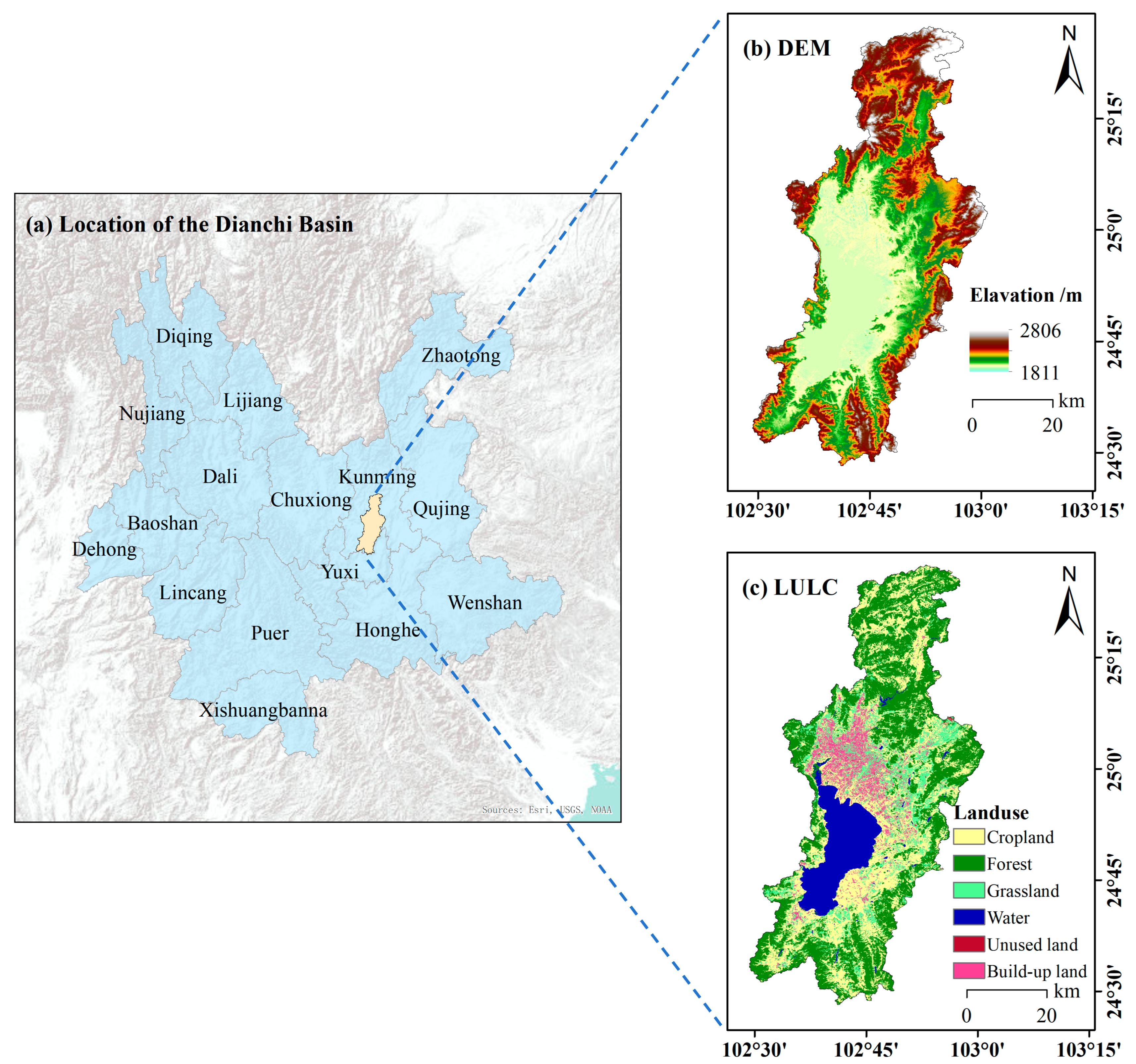
2.1. Study Area

The Dianchi Basin is located in the central part of Yunnan Province (Figure 1) and covers a total area of approximately 2886 km2. It is the largest freshwater lake basin in this province. The basin lies in the core area of Kunming City, which is a key economic, cultural, and transportation hub in Southwest China. Its topography is characterized by mountains, hills, and basins, with a subtropical highland monsoon climate. The average annual temperature is about 15 °C, and the annual precipitation is approximately 900 mm. The basin supports a variety of vegetation types including forests, grasslands, and wetlands, all of which have significant carbon storage potential. Furthermore, the Dianchi Basin has a high population density and an accelerated urbanization rate. The economy of the region is largely driven by industry, agriculture, and services while simultaneously striving to harmonize environmental preservation with economic advancement. In recent years, rapid urbanization and industrialization have led to significant transformations in land use [29]. The expansion of construction land, intensification of agricultural activities, and reduction in ecological land use have all had profound effects on the basin carbon stock.

2.2. Data Sources and Processing

We primarily utilize three types of data: land use, environmental driving, and land carbon density. First, land use data and environmental driving factors were integrated to simulate land use patterns under multiple scenarios for 2030. Second, land use data were combined with carbon density data to estimate the carbon stocks of terrestrial ecosystems within the watershed.

2.2.1. Land Use Data

Three periods of land use data from 2000 to 2020 were obtained from the China Annual Land Cover Dataset (CLCD) developed by Wuhan University [30] (https://zenodo.org/records/5816591#.ZAWM3BVBy5c, accessed on 21 January 2025). This dataset has a spatial resolution of 30 m, an overall classification accuracy of 80%, and offers a higher temporal resolution than those of the other land use CLCD products, seven of which are covered in this study area, with snow and wetlands not covered. After the field survey, it was found that although several wetland parks exist in the watershed, they consist of good ecological restoration and high woodland coverage and hence are mostly represented as woodlands in the land use data. According to earlier research, a small proportion of shrublands should be reclassified as woodland; therefore, the land use type includes six categories: cropland, woodland, grassland, watershed, unused land, and built-up land.

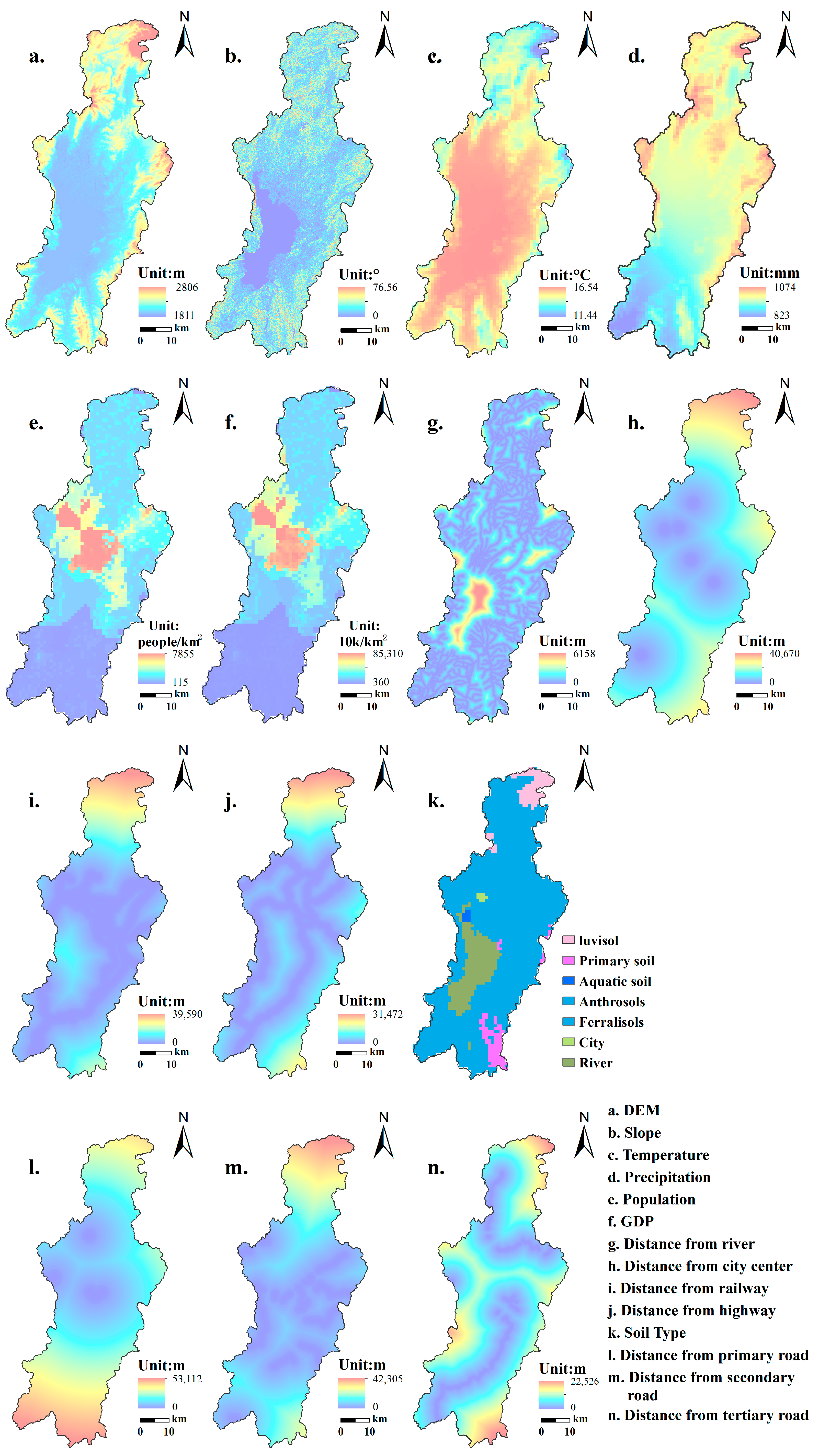
2.2.2. Environmentally Driven Datasets

Simulating and predicting future land use using the PLUS model requires the integration of historical land use data with environmental driving variables. Based on the modeling guide and the relevant literature, 14 environmental driving factors were selected, covering three main aspects: natural and socioeconomic conditions and locational attributes (Figure 2). Natural conditions include five parameters: digital elevation model (DEM) data, slope gradient, mean annual temperature, mean annual precipitation, and soil classification. Socioeconomic characteristics comprise two indicators: population density and gross domestic product (GDP) distribution. Location attributes encompass five spatial metrics: Euclidean distance to the nearest river, proximity to county administrative centers, and linear distances to railroads, highways, and roads. In addition to including socioeconomic data as a contributing factor influencing urban land expansion from 2000 to 2010, various socioeconomic data for 2010 were selected to restore the real environmental factor impacts during this period.
Digital elevation data were downloaded from the Geospatial Data Cloud Platform (https://www.gscloud.cn/, accessed on 17 January 2025), and slope information was derived using the slope analysis tool in GIS at a 30 m resolution. Data on soil type, mean annual temperature, mean annual precipitation, population, and GDP were obtained from the Resource and Environmental Science and Data Platform (https://www.resdc.cn, accessed on 16 February 2025), with all datasets standardized to a 1 km resolution. After mask extraction, reprojection, and setting the output to a 30 m resolution in ArcMap, environmental driving variables for the study area were generated. The data on location conditions mainly include highways, railroads, highways at all levels, and urban settlements downloaded from the OpenStreetMap website, whereas the road data of the Resource Environment Science and Data Platform are supplemented for the absence of primary and secondary roads. Finally, the distance weight data of the point (town point) and line (road network) elements were analyzed using the Euclidean distance tool.

2.2.3. Land Carbon Intensity Data

To assess the carbon effects within the Dianchi Watershed, land carbon density (CD) across various land types is a critical factor. Carbon stocks within ecosystems are classified using the InVEST model into four primary pools: aboveground carbon, representing vegetation biomass above the soil level; belowground carbon, encompassing roots and subterranean plant parts; soil carbon, referring to organic matter contained within the soil; and dead carbon, which consists of litter and dead plant residues [31]. The CD values used here were primarily obtained from the terrestrial ecosystem CD dataset of the National Ecological Science Data Center [32] and the other relevant literature [33]. Given the lack of CD datasets, specifically for the Dianchi Basin, we relied on earlier research [34] conducted in ecologically and geographically similar regions to estimate CD values for different land use types in the basin (Table 1).

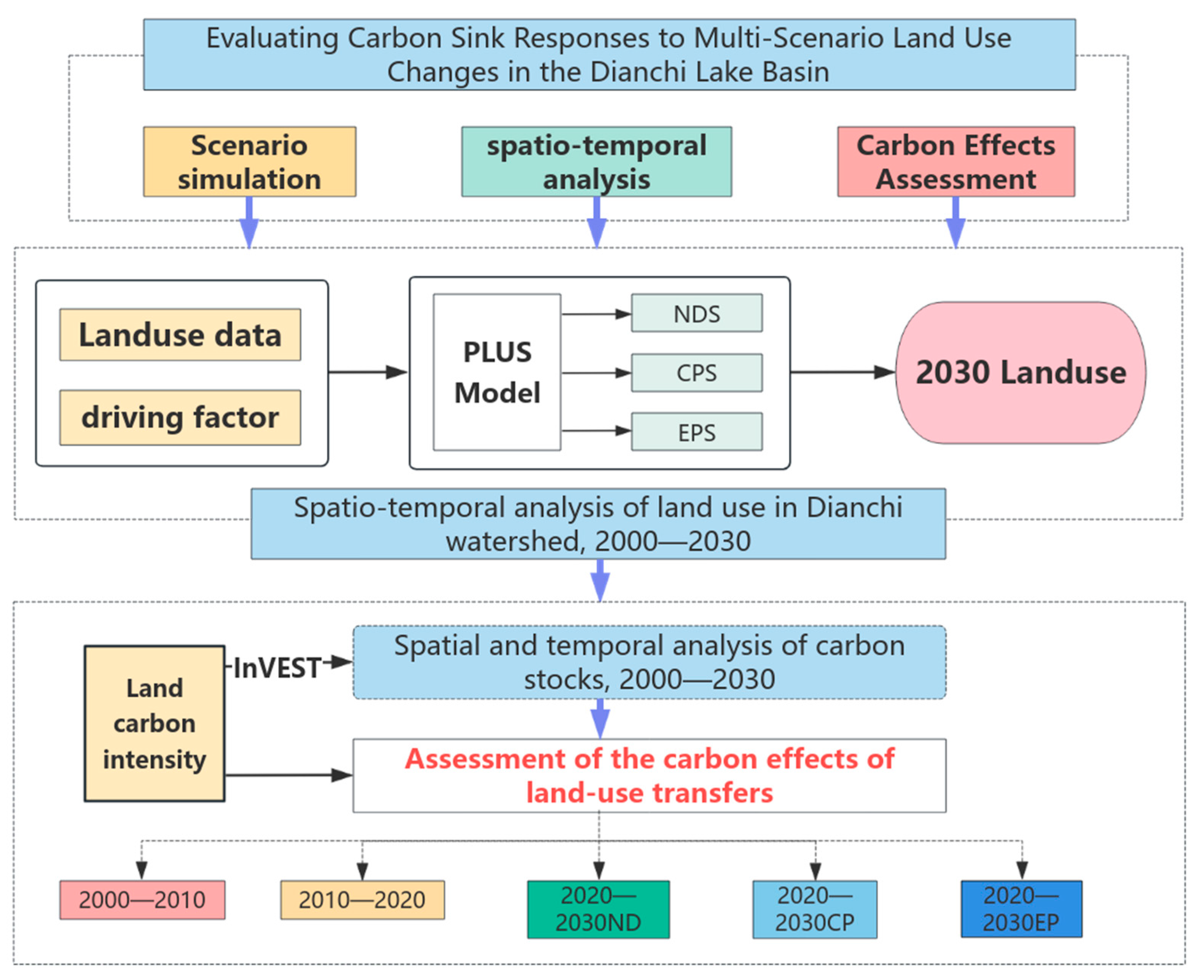
3. Research Ideas and Methods

The research framework was divided into two main components based on the objective of assessing the carbon effects in the Dianchi Basin (Figure 3). First, it analyzes LUC features throughout the two decades of accelerated urban growth between 2000 and 2020 as well as their effects on carbon stocks. This includes an analysis of land use evolution and the calculation of carbon stock variations. Second, the Markov PLUS model was employed to simulate land use patterns in 2030 under the three scenarios. The model was then used to assess the corresponding carbon stock changes under each scenario, with the aim of revealing the potential carbon effects resulting from future LUC in the Dianchi Basin.

3.1. Land Use Transfer Matrix

Designed to depict the temporal conversion of land use types, the land use transfer matrix serves as an essential analytical tool between the two periods [35]. Typically presented as a matrix, the rows reflect land categories at the start of the study, whereas the columns denote their states at the end. Each cell indicates the number of units transitioning between different land uses. The formula for this is presented in Equation (1):
M = m 11   m 21 m n 1 m 12     m 22 m n 2             m 1 n m 2 n m n n
where M and n denote the land use transfer matrix and land use type, respectively, and n = 6 (i.e., 1—cropland, 2—forestland, 3—grassland, 4—watershed, 5—unused land, and 6—built-up land).

3.2. Future Multi-Scenario Simulation Setup

To explore future land use demand under different development trajectories, three scenarios were established: Natural Development (ND), Cropland Protection (CP), and Ecological Protection (EP) scenarios. These simulations for 2030 were based on the historical land use transfer matrix of the Dianchi Watershed from 2000 to 2020. The specific settings were as follows:
ND followed the historical land transition probabilities of land change between 2000 and 2010 and used the Markov model to estimate land demand in 2030, reflecting the natural trend of land conversion across all categories.
The purpose of ND is to strictly guard the amount of existing arable land and limit the transfer of arable land while increasing the probability of transferring other land categories to arable land to achieve the protection goal of high-quality arable land. According to the requirements of the cropland protection target of the Yunnan Provincial Land Spatial Planning (2021–2035), the amount of cropland planned to be protected by 2030 is approximately 1.24 times the amount of permanent basic farmland. Therefore, we stipulate limiting the transfer of croplands under this scenario and increasing the transfer probability of forestland, grassland, and unused land to croplands by 25% to comply with the policy objective.
The Yunnan Provincial Dianchi Protection Regulations, revised in 2024, implement zoning protection for the watershed, prohibit construction activities in the core protection area, and achieve a balance of ecological protection through wetland restoration, return of farmland to forests, and other measures. The 14th Five-Year Plan proposed that the coverage rate of forests and grasslands in the watershed should reach 61%. Therefore, to meet the land use objectives under the EP, we increased the transfer probability of cultivated land and grassland to forest land by 30%, which indicates that the amount of ecological land will account for approximately 58% of the entire area in 2030, and prohibits the transfer of forest land, grassland, and water to cultivated and construction lands to strictly control the conversion of this type of ecological land.

3.3. PLUS Model

Land use change modeling is a core component of global change research and regional sustainable development studies [36]. Cellular Automata (CA), as a spatial simulation tool, effectively captures spatial proximity and path dependence in land use evolution. The core principle of CA is to determine the future state of each cell based on its current state, the states of its neighboring cells, and predefined transition rules. CA models were widely applied in studies of urban expansion, ecological transformation, and land use succession because of their capacity to simulate spatially dynamic processes [37].
Two significant constraints were identified in traditional CA models: (1) they struggle to automatically extract the driving mechanisms behind land use change [38], and (2) the spatial distribution patterns produced tend to be overly homogeneous, failing to accurately represent the complexity of real-world geographic and environmental conditions.
Consequently, the PLUS model emerged as an important extension of traditional CA models. The PLUS model is a meta-cellular automata framework based on raster data for simulating land use expansion [39]. It integrates the Land Expansion Analysis Strategy (LEAS) and the Cellular Automata based on multi-type Random Seeds (CARS) module. While retaining the advantages of the local self-organization and neighborhood effects of CA, the PLUS model enhances spatial simulation capabilities by incorporating machine-learning algorithms (e.g., Random Forest) and a multitype patch generation mechanism. These improvements significantly increase the ability of the model to represent spatial heterogeneity more realistically [40].

3.3.1. Model Structure and Principles

(1)
LEAS Module
The LEAS module was responsible for identifying the driving forces behind land expansion. First, historical samples of land use change are extracted, and the Random Forest algorithm is applied to quantify the contributions of various environmental and socioeconomic factors. This helps determine the variables most significantly influencing land transformation. Second, the module evaluates the development potential of land categories by analyzing past expansion characteristics and their associated drivers. The LEAS module generated a “driving force distribution map” serving as a key input for parameterizing the CARS module.
(2)
CARS Module
The CARS module is a patch-based multicellular automaton system designed to simulate spatial LUC. Unlike traditional CA models, often producing fragmented and overly smoothed land patterns, the CARS module introduces multiple random “seeds” and simulates land use expansion in patch form, resulting in more realistic land parcel shapes and clearer boundaries. This module incorporates transition probabilities, neighborhood effects, and a land competition mechanism to reconstruct spatial patterns with higher ecological and geographic realism [41].

3.3.2. Projected Land Requirements

Based on the specific settings of ND, CP, and EP, a Markov model was employed to extract the land use transition probabilities from 2000 to 2010. These transition matrices were used to calculate the projected land demand for each land use category in 2030 under ND (Equation (2)), which served as the target input for the PLUS model simulation. Land demand for the CP and EP scenarios was adjusted according to their respective modified transition probabilities.
S total = j = 1 n S future , j = i = 1 n S c u r r e n t , i × P i j
In Equation (2),
  • Sfuture,j represents the projected area of land use type j in the future.
  • Scurrent,i is the area of land use type i in the base year.
  • Pij is the probability of transition from type i to type j,
  • and n is the total number of land use categories.

3.3.3. Cost Matrix and Neighborhood Weight Setting

The cost matrix defines permitted and restricted transitions among land use categories over the course of the study period. A value of 1 denotes an allowable change between land types, and 0 signifies a restriction. Categories a–f represent cropland, forest land, grassland, water bodies, unused land, and built-up land, respectively. Under ND, the model adopts the historical land use cost matrix, while imposing restrictions on the expansion of construction land. Contrastingly, CP and EP modify conversion pathways according to policy priorities (e.g., prioritizing farmland conservation or ecological restoration), as detailed in (Table 2).
Additionally, neighborhood weights were introduced to characterize the spatial expansion tendencies of each land use type. These weights were derived by normalizing the historical expansion area of each land category, thereby reflecting the influence of spatial self-organization on land-parcel generation in the PLUS model.

3.3.4. Accuracy Check

The PLUS model evaluates the accuracy of simulation results using the kappa coefficient and Overall Accuracy (OA) to ensure the reliability of its performance. As a measure of simulation performance, the Kappa statistic ranges from 0 to 1, with higher values signifying better alignment between predicted and actual land use. Generally, a Kappa value above 0.75 reflects excellent agreement with observed data, while values between 0.60 and 0.75 indicate good consistency.
Here, based on land use and relevant driving factor data from 2000 to 2010, the PLUS model was applied to simulate land use patterns for 2020. Using the Confusion Matrix and the modules of the PLUS model, actual land use data from 2020 were incorporated for validation. The results show that the model achieved OA and kappa coefficient of 83.18% and 0.7686, respectively, indicating a high level of simulation accuracy and confirming the suitability of the model for future land use projections.

3.4. InVEST Carbon Stock Modeling

The InVEST model, developed by the Natural Capital Project of Stanford University, is a widely used tool for assessing ecosystem services. The Carbon Storage and Sequestration module was specifically designed to estimate carbon stocks and their spatial distribution across ecosystems, making it a key instrument for evaluating the impact of LUC on carbon sequestration capacity. Carbon storage in this module was computed using land cover types and their respective CDs. The carbon stock was calculated using Equation (3):
C = i = 1 n ( A i × D i )
where
  • C is the total regional carbon stock,
  • Ai is the area of land use type i,
  • Di is the carbon density of land use type i (i.e., the sum of above-ground carbon, below-ground carbon, soil carbon, and dead organic matter).
  • n is the number of land use types.

4. Results

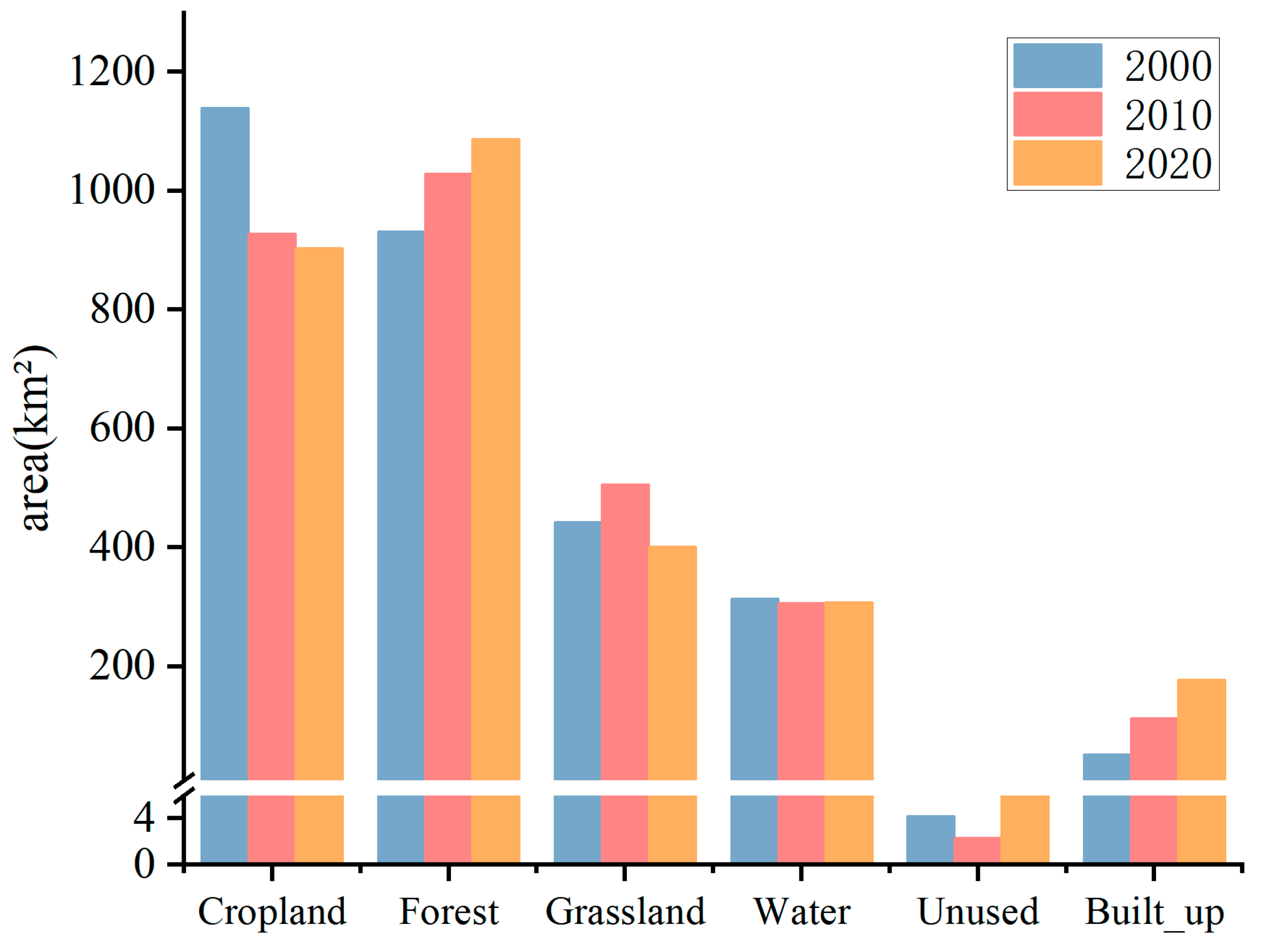
4.1. Analysis of Land Use Patterns in Dianchi Basin, 2000—2020

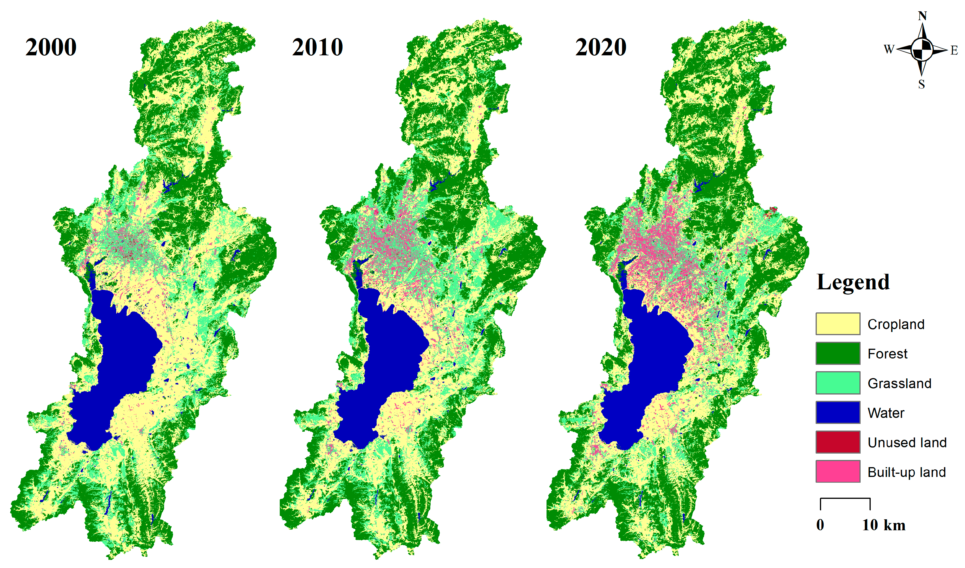
4.1.1. Land Use Characterization

From 2000 to 2020, the land use structure of the Dianchi Basin underwent substantial changes (Table 3 and Figure 4). Throughout 2000, 2010, and 2020, cropland and forests consistently dominated the landscape. Initially, cropland was the most prevalent land type; however, its area steadily declined from 1139.61 km2 to 903.37 km2, with its share decreasing from 39.49% to 31.31%. This trend indicates that the expansion of urban areas encroached on farmland and signaled a gradual decline in agricultural activities. Conversely, forestland showed a steady increase, rising from 931.39 km2 to 1028.31 km2, with its proportion increasing from 32.28% to 37.68%, suggesting that the ecological protection policies were effective. Grassland area initially expanded, peaking at 506.47 km2 in 2010, but then declined to 401 km2 by 2020, with its share fluctuating between 15.36% and 13.90%. These fluctuations are likely due to a combination of ecological restoration efforts and human disturbance. The relatively unchanged extent of the water bodies suggests that the water preservation initiatives in Dianchi Lake were effective. Unutilized land changed only slightly, but showed a small increase by 2020. Construction land increased markedly, from 52.58 km2 to 178.28 km2, with its proportion rising from 1.82% to 6.18%, reflecting rapid urbanization. Overall, the LUC in the Dianchi Basin is characterized by a reduction in cropland and an expansion of forest and construction lands, illustrating the dual forces of ecological conservation and urban development.
From 2000 to 2010, the spatial distribution of construction land increased significantly, particularly in the core urban zone of Kunming, which is adjacent to the Dianchi Lake Basin (Figure 5). This expansion followed a radial pattern outward from the city center, with cultivated land being converted into urban land, often accompanied by an increase in grassland. In the eastern (Chenggong District) and northeastern (Airport New Area) parts of the basin, signs of construction began to emerge, particularly in Chenggong District, where urban planning spurred the formation of a complete urban layout. Simultaneously, the mountainous forest areas surrounding Dianchi expanded based on their original coverage, concentrating woodland distribution.
Between 2010 and 2020, an urban pattern developed north of Dianchi Lake, forming the core urban area of Kunming. Most croplands in this region were converted to construction land, leading to denser urban development. Due to the spatial constraints posed by Dianchi Lake, urban expansion shifted eastward, reshaping the urban structure of the Guandu District. Forest coverage in the basin increased during this decade and became more spatially aggregated.
Over the past two decades, construction and arable lands in the basin have exhibited a clear antagonistic relationship, with the expansion of urban areas occurring largely at the expense of farmland, following a north-to-south pattern along Dianchi Lake. Vegetation in the surrounding mountainous areas recovered considerably, particularly in northern Panlong District, which is home to forests such as the Bailu Forest and Jindian National Forest Park. These changes reflect the positive outcomes of ecological protection efforts.

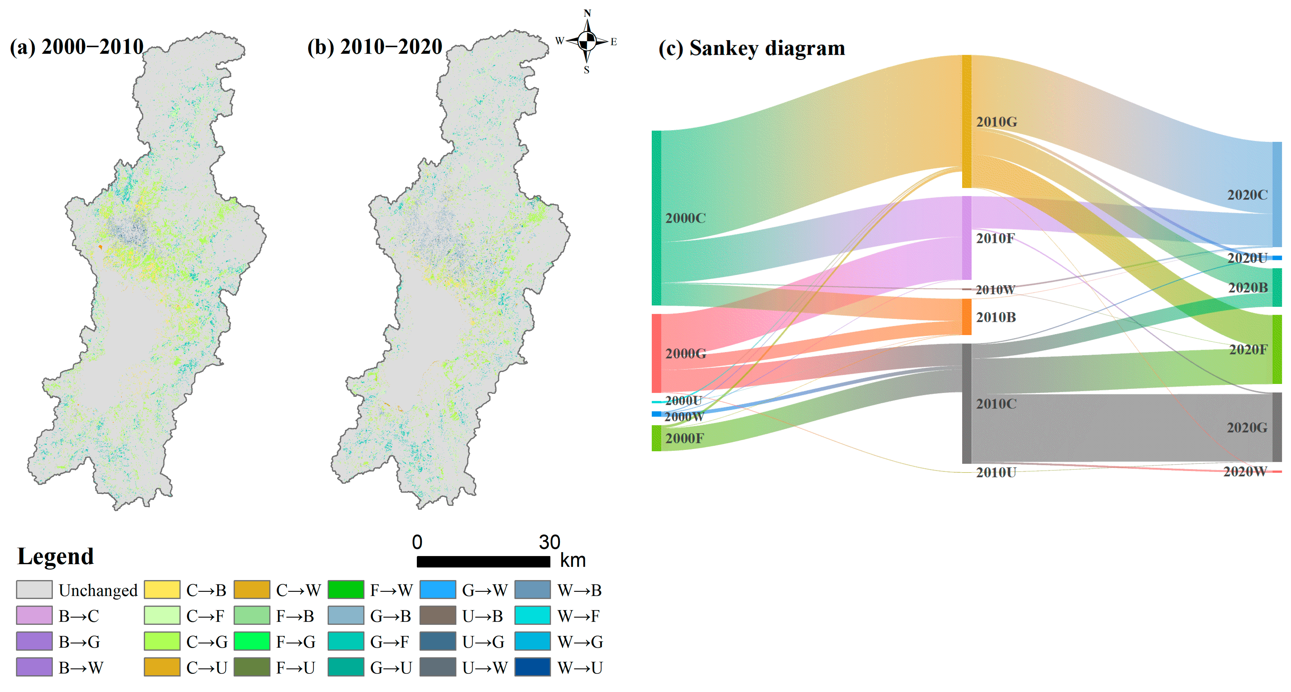
4.1.2. Land Use Trajectory Analysis

From 2000 to 2020, the land use transfer map of the Dianchi Basin (Figure 6) reveals that cultivated land experienced the largest outflow (403.22 km2), primarily being converted to forest (111.93 km2), grassland (203.00 km2), and construction (80.66 km2) lands. These findings imply that measures involving land use conversion from agriculture to natural vegetation, alongside accelerated urban development, greatly reduced cropland areas. Forest land saw a relatively low outflow (73.22 km2), but a significantly high inflow (229.11 km2), resulting in a net increase of 155.89 km2, which reflects the remarkable success of ecological restoration efforts. Grassland had an outflow of 254.50 km2, mainly being converted into cultivated (94.21 km2) and forest (115.95 km2) lands, highlighting the ongoing tension between agricultural expansion and ecological restoration. Water bodies showed minimal change, with only 10.27 km2 converted out and an inflow of just 3.18 km2, indicating that the water protection measures around Dianchi effectively curbed water loss. Construction land expanded by 125.77 km2 and was primarily sourced from cultivated land (80.66 km2) and grassland (41.45 km2). The actual rate of expansion during this period exceeded expectations, emphasizing the mounting pressure from urbanization.
LUC in the Dianchi Basin is closely tied to the “Ecological Civilization” strategy of Yunnan Province. Approximately 111.93 km2 of cropland was directly converted due to the “Returning Farmland to Forest” policy implemented between 2000 and 2010. After the 2013 revision of the Regulations on the Protection of the Dianchi Basin, the amount of converted water area declined by 62% compared with that in the previous decade. The “Multiple Planning Integration” territorial spatial plan of Kunming imposes stricter controls on construction land expansion. The average annual conversion of land for construction use from 2010 to 2020 (6.29 km2) fell by 18.5% compared with that in 2000–2010 (7.72 km2). However, further efforts are needed to strengthen the coordinated controls on farmland occupation, compensation balance, and ecological red lines to better reconcile the conflict between ecological conservation and urban development.

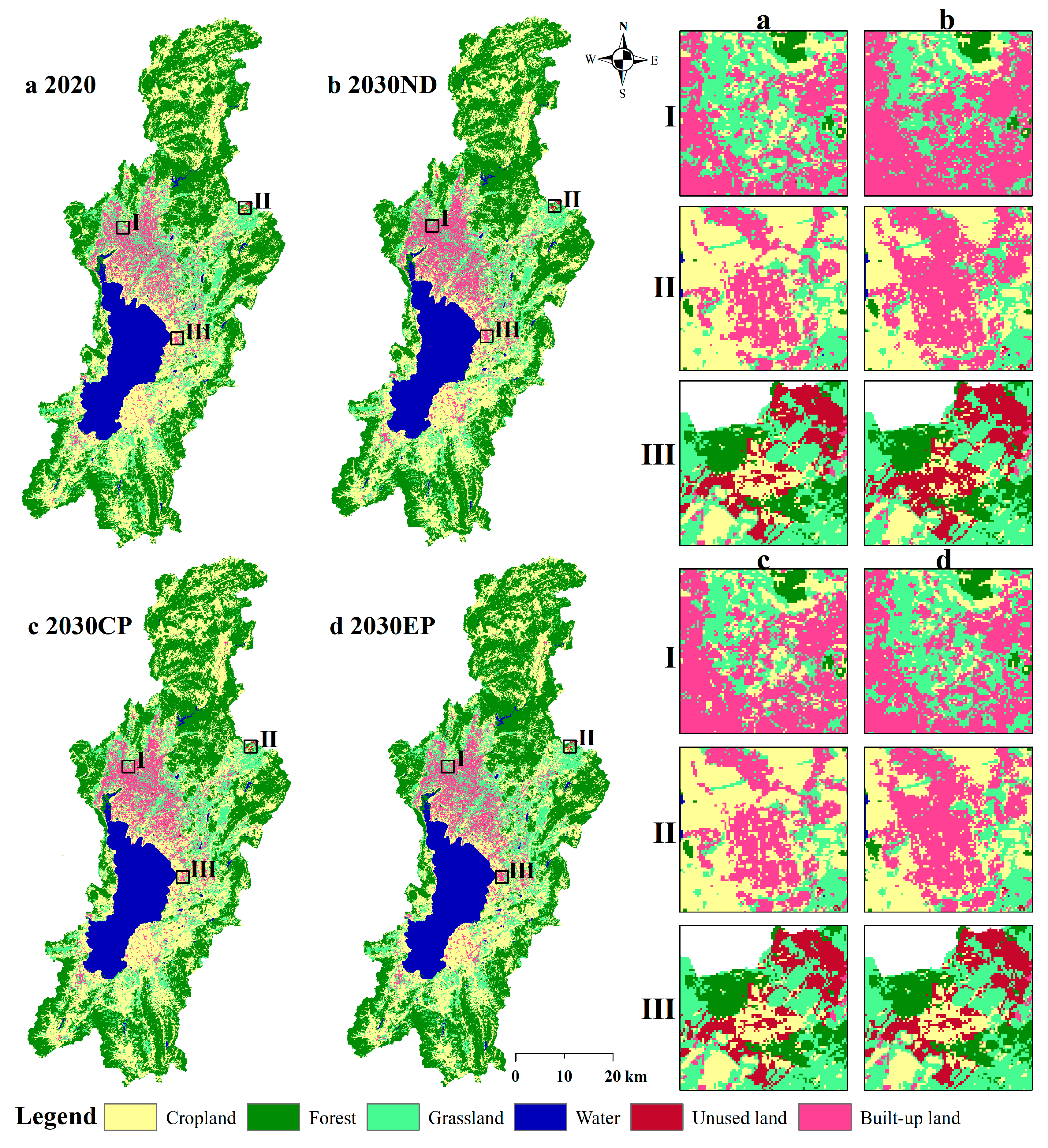
4.2. Multi-Scenario Land Use Simulation Analysis of Dianchi Watershed in 2030

The simulation results of land use in the Dianchi Watershed under multiple scenarios for 2030, based on the PLUS model, showed significant differences (Figure 7).
Under ND, the areas of arable land, grassland, and unutilized land decreased, especially arable land, which shrank by approximately 43.14 km2. Water bodies increased slightly, influenced by the presence of wetland parks along Dianchi Lake. Both forest and construction lands expanded considerably. Urbanization occurs mainly through the conversion of cropland and grassland, whereas forested areas in the surrounding mountainous regions experience prominent restoration.
In CP, the transfer of existing arable land is strictly limited, whereas conversion of other land types into croplands is promoted. Consequently, the cultivated land area reached a maximum of 914.12 km2, nearly matching that of the 2010 levels. Although construction land continued to increase, its growth rate was slower than that for ND. Forest and grassland areas decreased, and forestland expansion was prominently suppressed. Grasslands are the primary source of cropland compensation due to their topographic suitability.
Under EP, by 2030, cropland will decrease by 82.06 km2, forest land will increase by 42.23 km2, grassland will increase by 18.69 km2, water bodies will expand by 2.53 km2, and construction land will grow by 19.40 km2. The overall increase in ecological land, forest, grassland, and water indicates a more balanced and rational land use outcome. The reduced croplands were primarily converted to forest and grassland, and the growth of built-up land was the slowest among the three scenarios.
Conclusively, the LUC in the Dianchi Watershed by 2030 demonstrates marked variability depending on the scenario considered. Under ND, cropland decreases, built-up land expands rapidly, and urban growth coexists with some ecological restoration. Under CP, cropland area increases and construction land growth slows, reflecting the influence of farmland conservation policies. Under EP, cropland decreases sharply, while forest and grassland areas expand significantly, and construction land growth is minimized, demonstrating the strict enforcement of ecological protection policies.

4.3. Analysis of Changes in Carbon Stocks, 2000—2030

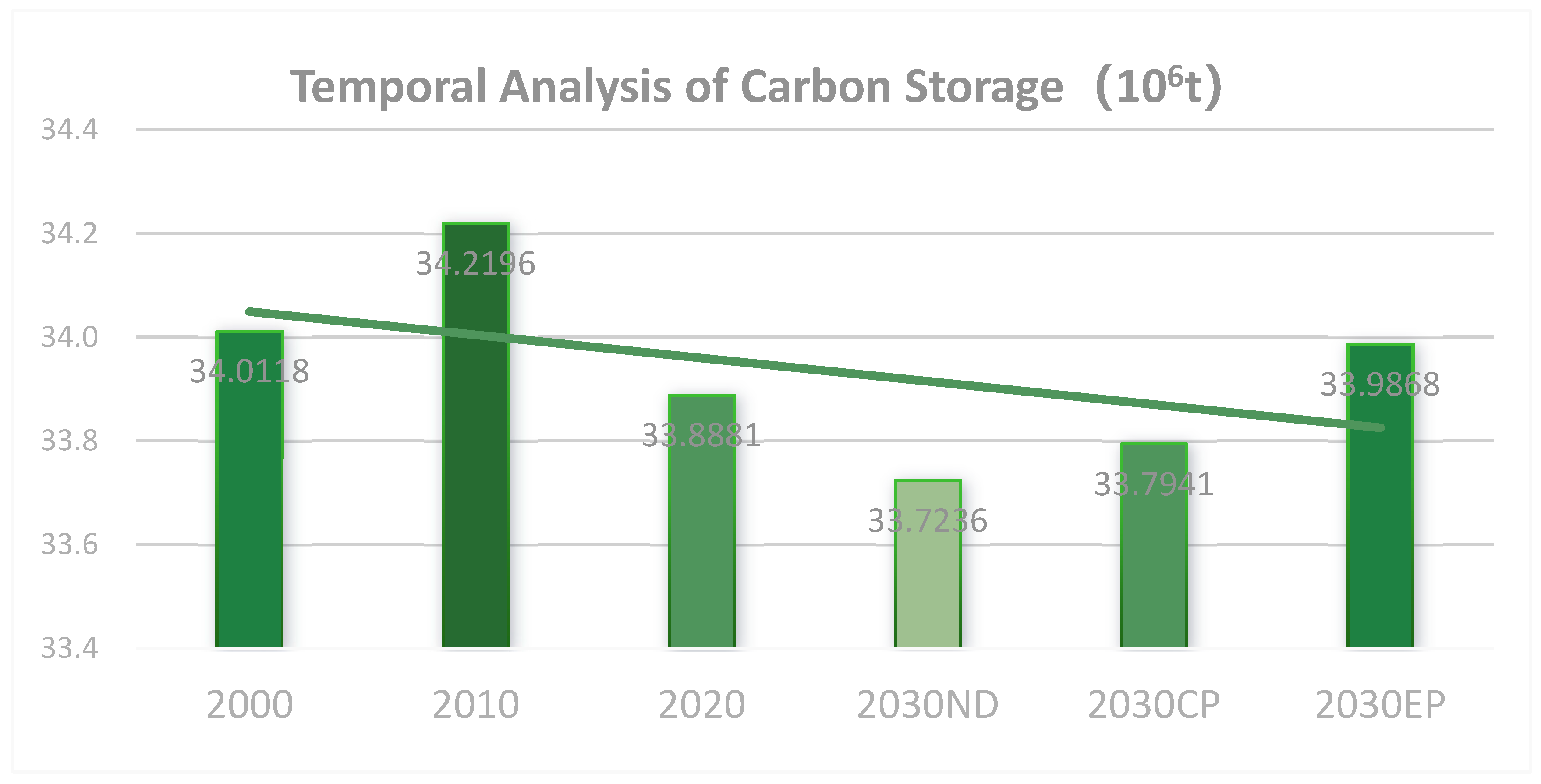
4.3.1. Time-Series Analysis of Carbon Stocks

Since 2020, when China announced its “dual-carbon target” at the United Nations General Assembly and pushed for a low-carbon transition in its national land use policy, strong concerns have gradually been expressed about carbon effects in various regions. Simultaneously, the results of the third national land survey show that between 2010 and 2020, the area of arable land nationwide decreased from 1.918 to 1.865 billion mu, and the average annual growth of construction land increased by 1.5%, leading to a significant increase in carbon emissions. It was highlighted that the land changes in Kunming City, Dianchi Basin, during this period were characterized by “three increases and three decreases” [42], which made it necessary to analyze carbon stock. It was found that carbon stock in the Dianchi Basin changed significantly over the past 30 years, with a trend of “initial increase followed by decline” (Figure 8).
In the decade from 2000 to 2010, an increase was observed in the areas covered by forests and grasslands, contributing to a rise in total regional carbon stock due to their high CD. Between 2010 and 2020, significant LUC occurred in the basin, highlighted by a decrease in the amount of grassland and a rapid expansion of built-up land at a rate of 1.5 times, leading to an outward loss of carbon stocks during this period. However, from 2020 to 2030, under ND, carbon stock continues to decline, reaching 33.72 × 10⁶ tons. During this period, both cropland and ecological land decrease, resulting in the lowest carbon stock among the three scenarios. Under CP, carbon stock reaches 33.79 × 10⁶ tons—comparable to that of ND. Although cropland is preserved, the scenario still demonstrates a relatively low carbon storage capacity of cropland compared with that of other ecological land types.
Contrastingly, under EP, carbon stock in the Dianchi Basin reaches its highest value. The carbon storage potential of a regional ecosystem can be maximized by increasing the area of forests, grasslands, and water bodies. Furthermore, the expansion of construction land slows significantly, aligning more closely with the concept of “harmony between humans and nature.” However, arable land continues to decline sharply because of the increasing demand for diverse land use functions.

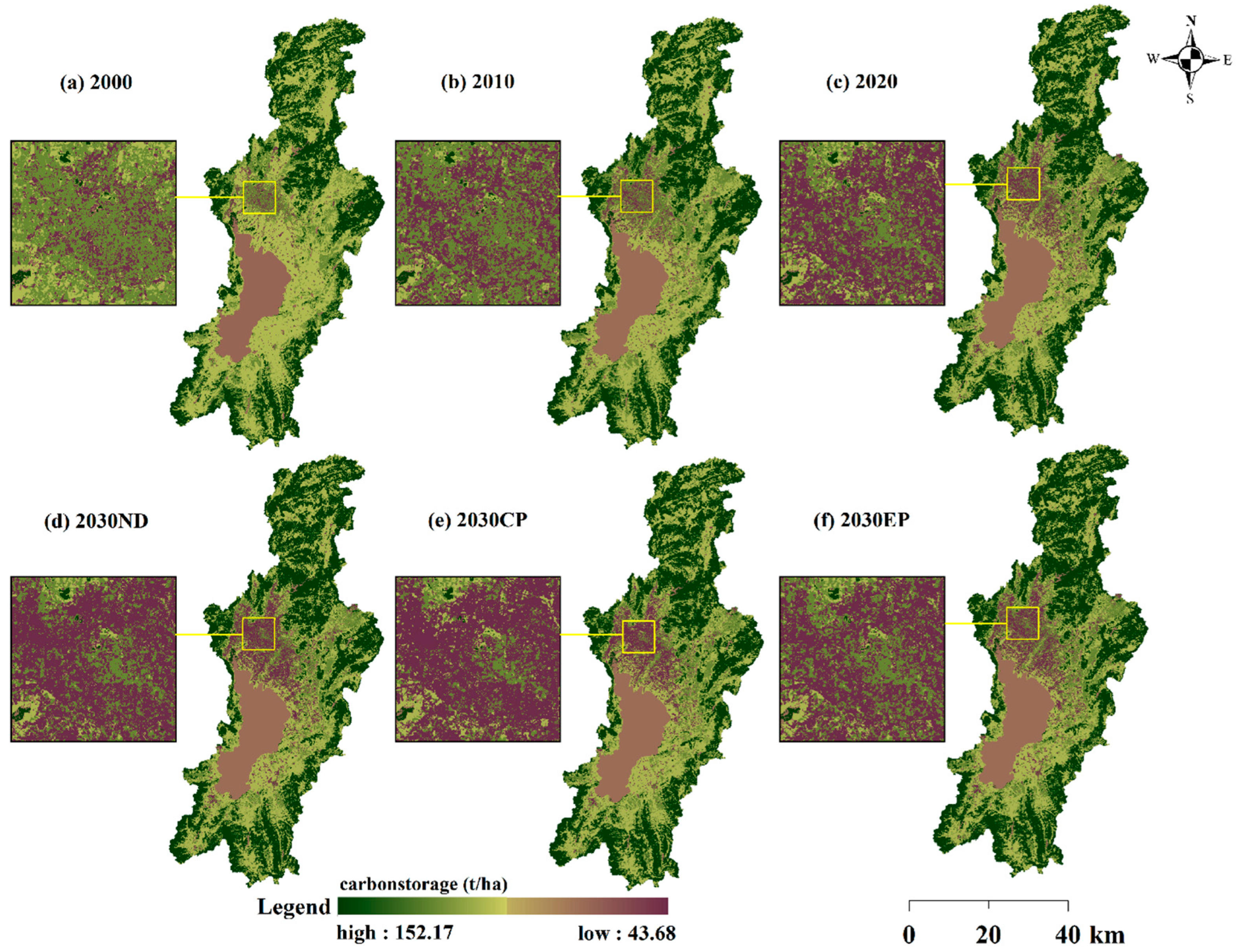
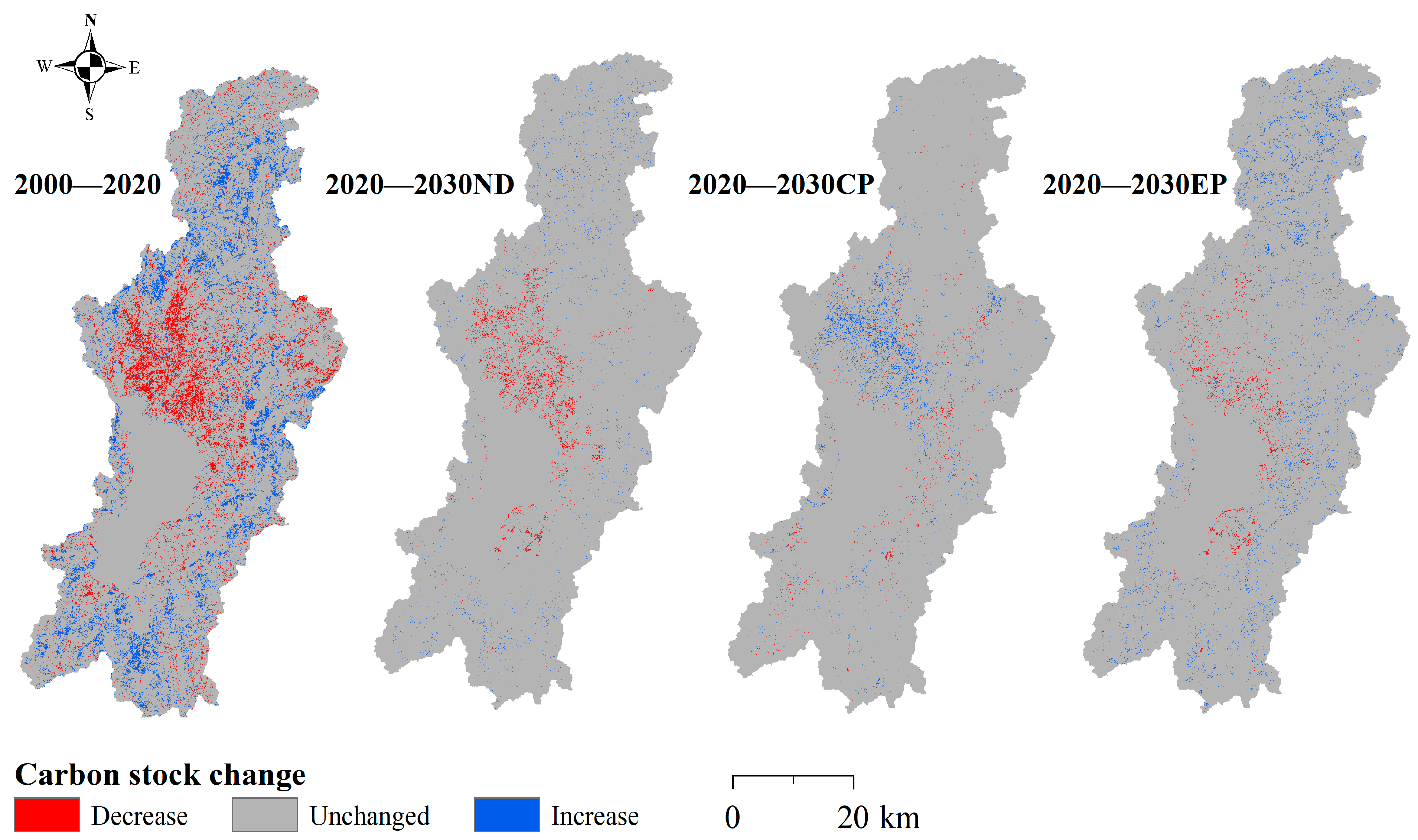
4.3.2. Spatial Characterization of Carbon Stocks

The spatial distribution of carbon stocks in the Dianchi Basin exhibits pronounced spatial heterogeneity (Figure 9), with the central part of the basin being well-developed with mostly construction land, which results in low carbon stocks in the area; while the surrounding areas of the basin are forested and grassland, which form high carbon stock areas, and hence, the whole area is characterized by “low in the center, high around the periphery.” Simultaneously, with time, the low-carbon storage area in the middle of the watershed has been expanding, while the surrounding high-carbon storage area has become more aggregated.
Low-carbon areas were primarily composed of built-up and unused land. As construction land serves as the foundation for economic development in the Dianchi Watershed, it has expanded outward, concentrating on low-carbon zones along the northern and eastern shores of Dianchi Lake. Additionally, development saturation on the north bank shifted urban expansion to the east bank, suggesting that carbon stocks in land use types along the eastern shore will likely decline in the future.
Medium-carbon areas are primarily composed of water bodies and croplands. Since 2000, major water systems in the basin, such as Dianchi Lake, rivers, and reservoirs, have remained under control, keeping the carbon stocks associated with aquatic land use relatively stable. Cropland, once the dominant land use type and a major carbon reservoir, significantly reduced due to urban sprawl on the north bank, resulting in substantial carbon loss. Meanwhile, the carbon stock center for croplands gradually shifted southeastward.
Regions with high carbon content are primarily located in the hills encircling the basin, where woodlands and grasslands are the primary contributors to carbon sequestration. Forested land showed a continuous upward trend over the last three decades. As the most carbon-dense land use type in the basin, woodlands play a dominant role in shaping the carbon storage profile of the region.
Spatial differences in carbon stock distributions across the years revealed the spatial patterns of carbon stock changes in the Dianchi Basin (Figure 10). From 2000 to 2020, the spatial distribution of carbon stocks underwent significant changes, exhibiting a clear pattern of polarization leading to substantial carbon stock losses in the northern part of the basin, whereas increased forest and grassland coverage around the basin resulted in widespread carbon stock gains. Over the 20-year period, areas with decreased and increased carbon stocks accounted for approximately 10.47% and 15.34% of the total basin area, respectively.
When comparing the carbon stock distributions between 2020 and 2030 under different scenarios, the overall spatial pattern remained relatively stable. Under ND, reductions in cropland and grassland conversion to construction land continued to dominate the central region of the basin, with 1.57% of the area showing a decrease in carbon stocks. Under CP, potential land conversion from cropland is restricted, thus preserving cropland areas. Consequently, construction land expansion relies primarily on grasslands, which significantly limits the extent of land conversion and increases carbon stocks in the central basin.
The increase in carbon stocks was the most pronounced under EP. Forest and grassland areas in the surrounding mountains expanded further, effectively enhancing the carbon sequestration capacity of the basin and mitigating carbon loss from urban development.

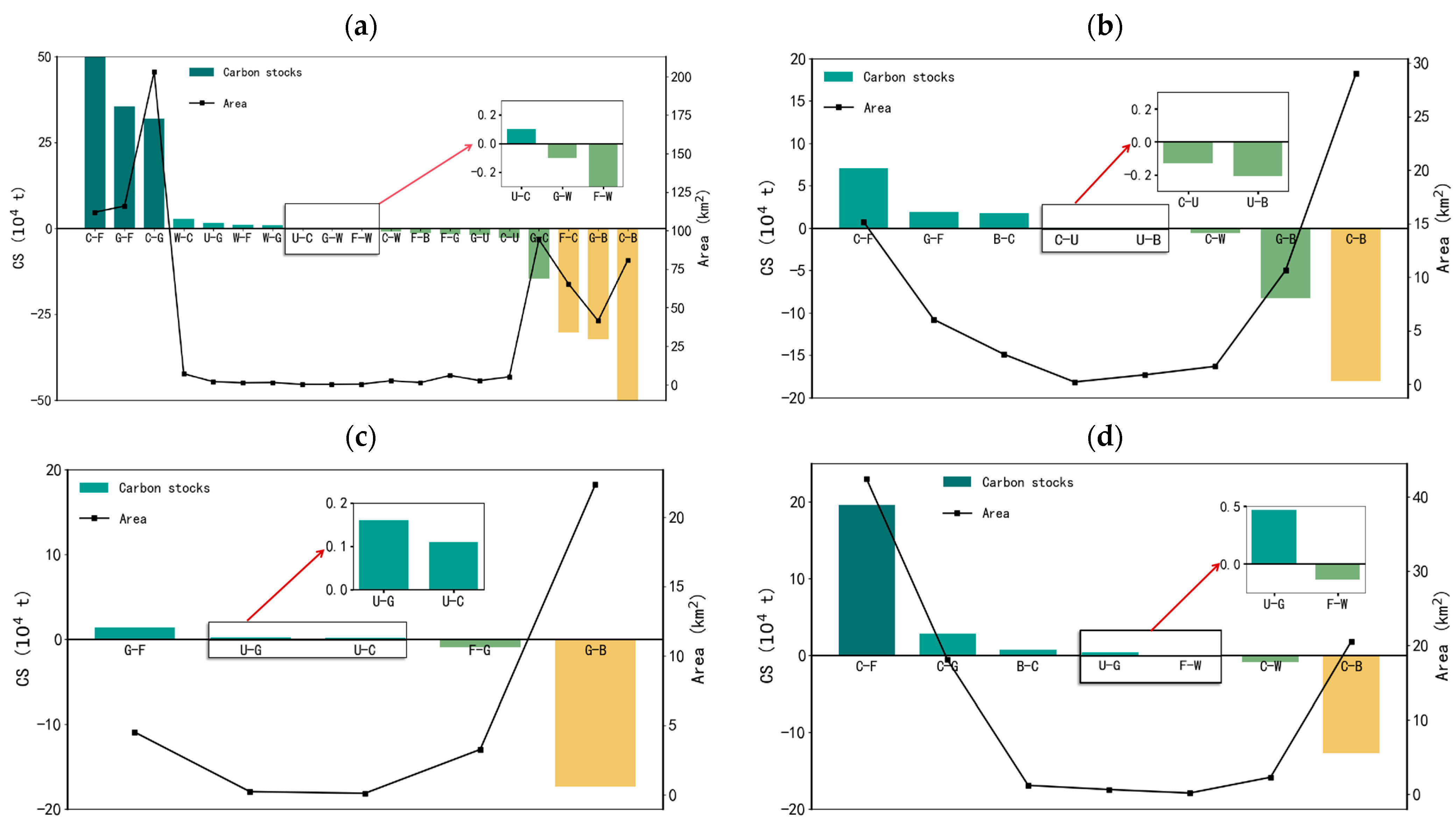
4.3.3. Impact of Land Use Shifts on Regional Carbon Stocks

Land use conversion directly influences ecosystem carbon stocks by altering the surface vegetation cover and the soil carbon pool. Therefore, analyzing specific land use transitions is therefore essential to accurately identify the sources of regional carbon stock gains and losses. In the Dianchi Basin, carbon stock increases were primarily driven by the conversion of cropland and grassland to forestland and the conversion of cropland to grassland. Conversely, carbon stock losses mainly result from the conversion of forest land, grassland, and cropland into construction land (Figure 11).
From 2000 to 2010, the impact of land use change on carbon stock in the Dianchi Basin was mainly characterized by the conversion of cropland to forest and grassland, which increased the carbon stock by 314,000 t and 292,000 t, respectively. Additionally, the conversion of grassland to forest contributed to an increase of 217,000 t. These results reflect the significant success of the “Grain for Green” policy in promoting the return of farmland to forests and grasslands. However, some instances of agricultural reclamation (i.e., converting forest and grassland back to cropland) resulted in a carbon stock loss of 233,000 t. Overall, the net change in carbon stock during this period was positive, although localized agricultural expansion still posed a threat to the carbon sink function.
Between 2010 and 2020, the influence of land use change on carbon stocks became more complex. Cropland converted to forest land increased the carbon stock by 276,000 t, and grassland converted to forest added another 168,000 t. The conversion of cropland and grassland into urban areas caused losses in carbon stocks amounting to 231,000 t and 173,000 t, respectively, indicating mounting urbanization pressure on carbon sinks. Additionally, the shift from grassland to cropland contributed to an added loss of 188,000 t, underscoring persistent ecological degradation due to agriculture. Overall, the carbon stock trend during this period was negative, and urban expansion emerged as the primary driver of carbon sink reduction.
Looking ahead to 2030, under ND, the region will gain approximately 105,000 t of carbon stock through conversion to forest and grassland. However, the extensive transformation of agricultural and grassland areas into built-up land under urban expansion will lead to a continued decline in carbon stocks, significantly impairing the carbon sink function of the ecosystem. Under CP, land conversion will be constrained, particularly for croplands, shifting development pressure to grassland. Consequently, the conversion of grassland to construction land will cause a carbon stock loss of approximately 232,000 t. Under EP, croplands will primarily be converted to forest and grassland, resulting in a carbon stock gain of 232,000 t. In this scenario, ecological land types (forest, grassland, and water bodies) increase, the expansion of built-up land is suppressed, and carbon losses from encroachment on croplands are mitigated.
Summarily, regional carbon stock increases are mainly driven by conversion to forests and grasslands. Contrastingly, urban expansion (cropland and grassland to construction land) and agricultural reclamation (forest and grassland to cropland) are the principal causes of carbon stock loss.

5. Discussion

5.1. Significance of Coupled Land Use and Carbon Stock Studies

Traditional studies focused primarily on single models or descriptive analyses of historical data [43,44]. Contrastingly, we integrated the PLUS and InVEST models with the Random Forest algorithm and multi-type patch generation rules to simultaneously account for the spatial heterogeneity of land use in complex terrain areas and the dynamic response of carbon stock estimation. Beyond merely reviewing historical changes, we systematically compared carbon stock trends under different land use policies and planning scenarios, namely ND, CP, and EP. This multi-scenario evaluation approach enables a more comprehensive understanding of the potential changes in regional carbon sink functions under varying policy constraints [45]. It also offers decision-makers more detailed feedback on policy outcomes and early warnings of potential risks, outperforming traditional single-scenario projections in both scope and precision.
Furthermore, we not only emphasize overall changes in carbon stock but also link spatial patterns of carbon loss to specific regional policies—such as the “One Lake, Four Zones” strategy outlined in the Kunming Territorial Spatial Master Plan (2021–2035). This reveals the variation of carbon stock dynamics across key areas, including the urban core and the eastern shore of Dianchi Lake, under different development scenarios. This spatially explicit approach provides a solid foundation for the targeted implementation of land use policies and enriches the existing discourse on the spatial effects of environmental and planning policies.
We systematically assessed the impacts of LUC on carbon stocks in the Dianchi Basin from 2000 to 2030, revealing the distinctive carbon cycle response characteristics of highland lake ecosystems. The results show a clear trend of “first increasing and then decreasing” in carbon stocks, closely aligning with the implementation stages of regional policies. From 2000 to 2010, the “Grain for Green” project significantly boosted carbon stocks, while the rapid expansion of construction land after 2010 led to intensified carbon loss. Compared with that of the lowland lake basins, the Dianchi Basin exhibits greater sensitivity to carbon response, with the intensity of carbon loss from construction land reaching approximately 39 t/ha [46]. This increased sensitivity is largely attributed to the unique soil structure of the region and the vulnerability of its plateau ecosystem [47].
As a representative highland lake ecosystem in Southwest China, the Dianchi Basin is grappling with the tension between ecological protection and economic development amid rapid urbanization [39]. Under the “dual carbon” strategy, multi-scenario simulations reveal that the carbon sink potential in the Dianchi Basin could reach 33.99 × 106 t by 2030 under EP—an increase of 0.26 × 10⁶ t compared with that of ND—highlighting the effectiveness of territorial spatial optimization in achieving carbon neutrality goals. Accordingly, a “three-space optimization under carbon constraints” framework is proposed for plateau lake basins: (1) delineate core carbon sink protection zones around the lake and implement carbon compensation mechanisms for construction land expansion; (2) promote ecological transformation of cropland by enhancing the carbon sink potential of marginal farmland through no-tillage and crop rotation; and (3) innovate mechanisms for realizing the value of ecological products by incorporating incremental carbon sinks into the ecological compensation accounting system of the Central Yunnan urban agglomeration. This approach offers a valuable reference model for similar regions facing the dilemmas of development and emission reduction.

5.2. Mechanisms of Policy Influence on Carbon Stocks

This study reveals that policies exert both direct and indirect influences on carbon stock regulation, primarily in the following ways:

5.2.1. Direct Regulatory Effects

Under EP, strict controls on construction land expansion and enhanced protection of high-carbon storage land types such as forest land, grassland, and water bodies significantly improve ecological quality and enhance the regional carbon sink capacity. For example, under this scenario, the area of built-up land in the Dianchi Watershed in 2030 is reduced by approximately 10% compared with that of ND, directly avoiding approximately 104 t of carbon loss, whereas forest land under the ecological plan and grassland increase by approximately 12 × 104 t and 2 × 10⁴ t, respectively. This indicates that well-designed ecological protection policies can directly expand carbon sink areas and effectively reverse carbon stock declining trends. In practice, measures, such as converting farmland to forest or grassland and delineating ecological redlines, act as direct interventions to enhance carbon sequestration by increasing vegetation cover and improving ecological functions [48].

5.2.2. Indirect Regulatory Effects

Policies also indirectly shape the spatial and temporal distribution of carbon stocks by optimizing the territorial spatial layout and guiding urban expansion and agricultural activities more rationally. For instance, under CP, restrictions on the conversion of farmland into construction land help curb uncontrolled urban sprawl and reduce the scale of expansion of building land from 1.2 times under ND to 1.1 times, thereby reducing carbon loss caused by land use change [49]. Furthermore, while advancing regional economic growth, policy measures also encourage the development of environmentally friendly infrastructure and the rollout of habitat rehabilitation initiatives, contributing to long-term improvements in ecosystem structure and carbon cycling [50].

5.2.3. Uncertainty in the Spatio-Temporal Effects of Policies

Although some policies may yield prominent ecological improvements in the short term, their long-term effectiveness is influenced by multiple factors such as economic development, population migration, and external environmental changes [51]. The scenario simulations here show that future changes in carbon stocks are highly dependent on policy enforcement, demonstrating strong scenario dependence and policy sensitivity. Therefore, territorial spatial planning should consider the continuity and regional adaptability of policies and establish dynamic adjustment mechanisms to cope with long-term environmental changes and potential uncertainties.

5.3. Research Limitations and Prospects

Although we made significant advancements in methodology and scenario development, this study has several limitations. First, the InVEST model uses static CD parameters that may not fully capture the interannual variability of subtropical vegetation or respond adequately to the impacts of climate change on carbon stock dynamics. Second, the role of dissolved organic carbon (DOC) in Dianchi Lake was not included in the overall carbon cycle analysis [52]. Future research could address these limitations by integrating dynamic CD datasets, leveraging remote sensing and long-term field observations to enhance model responsiveness, and including aquatic carbon processes within a comprehensive carbon cycle framework.

6. Conclusions

To investigate the carbon effects driven by land use changes in the Dianchi Basin, we evaluated carbon stock changes from 2000 to 2030 using land use data and CD parameters by coupling the PLUS and InVEST models. A systematic analysis of land use transformation and carbon stock dynamics over a 30-year period led to the following key findings:
(1)
Urban expansion has driven sustained cropland loss—a 20.7% reduction from 2000 to 2020—while construction land area has increased by 3.4 times. Simultaneously, ecological restoration efforts contributed to a 16.7% increase in forest land, forming a spatial differentiation pattern of “cropland encroachment in the lakeside development belt and forest restoration in the mountainous ecological zones.” The grassland area initially expanded due to fallow policies before 2010 but experienced a net decline thereafter due to pressure from construction land expansion.
(2)
Carbon stock spatially exhibits a “high in the north, low in the south” aggregation pattern: a high carbon stock is maintained in the northern and mountainous areas due to forest protection, whereas the central lakeshore zone becomes a carbon sink depression due to urban sprawl. Temporally, the carbon stock shows a “rise-then-decline” trend, with a net decrease of 0.33 × 10⁶ t from 2000 to 2020. This loss was mainly attributed to soil carbon depletion from cropland fragmentation and vegetation carbon loss due to expansion of construction land, accounting for 53% of the total reduction.
(3)
By 2030, under ND, carbon stock is projected to decline by 0.16 × 10⁶ t compared with that in 2020, highlighting the potential crisis of carbon loss under current land policies. EP could raise carbon stock to 33.99 × 10⁶ t through forest restoration, although at the expense of a 9% reduction in cropland and a relatively slow urban expansion (only a 10.8% increase in construction land), indicating a shift toward ecological prioritization. CP, balancing moderate urban expansion (12.9% increase from 2020) with enforcement of cropland redlines, achieves an incremental carbon gain of 0.11 × 10⁶ t—proving to be the most effective pathway for harmonizing ecological and economic objectives.

Author Contributions

Conceptualization, Q.X. and S.W.; data curation, Z.G. and Q.R.; formal analysis, Q.X.; funding acquisition, Q.X.; methodology, Z.G. and Y.L.; project administration, S.W.; software, Z.G.; supervision, Q.X.; validation, Q.R.; visualization, Z.G. and S.W.; writing—original draft, Z.G. and Y.L.; writing—review and editing, S.W. All authors have read and agreed to the published version of the manuscript.

Funding

This research was funded by the National Natural Science Foundation of China (grant numbers: 42161065 and 41461038), the Major Science and Technology Special Project in the Yunnan Province (202202AD080010), and the Yunnan Province Basic Research Key Program (202401AS070037).

Institutional Review Board Statement

Not applicable.

Informed Consent Statement

Not applicable.

Data Availability Statement

The datasets used and/or analyzed during the current study are available from the corresponding author upon reasonable request.

Acknowledgments

We would like to express our sincere gratitude to the editors and reviewers who invested considerable time and effort into their comments on this paper. We have gained useful insights from and would like to express our sincere gratitude to A-Xing Zhu for his lecture “Condensation of scientific problems and writing of SCI papers and grant projects”.

Conflicts of Interest

The authors declare no conflicts of interest.

Abbreviations

The following abbreviations are used in this manuscript:
LUCLand Use Change
CDCarbon Density
NDNatural Development
CPCropland Protection
EPEcological Protection

References

  1. Piao, S.; Huang, M.; Liu, Z.; Wang, X.; Ciais, P.; Canadell, J.G.; Wang, K.; Bastos, A.; Friedlingstein, P.; Houghton, R.A.; et al. Lower land-use emissions responsible for increased net land carbon sink during the slow warming period. Nat. Geosci. 2018, 11, 739–743. [Google Scholar] [CrossRef]
  2. Winkler, K.; Fuchs, R.; Rounsevell, M.; Herold, M. Global land use changes are four times greater than previously estimated. Nat. Commun. 2021, 12, 2501. [Google Scholar] [CrossRef]
  3. Masalvad, S.K.; Patil, C.; Vardhan, A.R.; Yadav, A.; Lavanya, B.; Sakare, P.K. Predicting land use changes and ecosystem service impacts with CA-Markov and machine learning techniques. Environ. Dev. Sustain. 2025, 1–23. [Google Scholar] [CrossRef]
  4. Baumbach, L.; Hickler, T.; Yousefpour, R.; Hanewinkel, M. High economic costs of reduced carbon sinks and declining biome stability in Central American forests. Nat. Commun. 2023, 14, 2043. [Google Scholar] [CrossRef]
  5. Yuan, X.; Chen, X.; Ochege, F.U.; Hamdi, R.; Tabari, H.; Li, B.; He, B.; Zhang, C.; De Maeyer, P.; Luo, G. Weakening of global terrestrial carbon sequestration capacity under increasing intensity of warm extremes. Nat. Ecol. Evol. 2024, 9, 124–133. [Google Scholar] [CrossRef]
  6. Friedlingstein, P. Carbon cycle feedbacks and future climate change. Philos. Trans. Ser. A Math. Phys. Eng. Sci. 2015, 373, 20140421. [Google Scholar] [CrossRef]
  7. Xu, K.; Zou, G.; Hu, H. Forest Carbon Sequestration Functions and Mitigation Strategies for Global Climate Change; IntechOpen: London, UK, 2025. [Google Scholar]
  8. Huang, M.; Mamitimin, Y.; Abulizi, A.; Yimaer, R.; Tiemuerbieke, B.; Chen, H.; Tao, T.; Ma, Y. Integrated assessment of land use and carbon storage changes in the Tulufan-Hami Basin under the background of urbanization and climate change. Int. J. Appl. Earth Obs. Geoinf. 2024, 135, 104261. [Google Scholar] [CrossRef]
  9. Houghton, R.A.; House, J.I.; Pongratz, J.; Van Der Werf, G.R.; Defries, R.S.; Hansen, M.C.; Le Quéré, C.; Ramankutty, N. Carbon emissions from land use and land-cover change. Biogeosciences 2012, 9, 5125–5142. [Google Scholar] [CrossRef]
  10. Yin, X.; Yu, X.; Qin, L.; Jiang, M.; Lu, X.; Zou, Y. Reclamation leads to loss of soil organic carbon and molecular complexity: Evidence from natural to reclaimed wetlands. Soil. Tillage Res. 2025, 248, 106436. [Google Scholar] [CrossRef]
  11. Kohestani, N.; Rastgar, S.; Heydari, G.; Jouibary, S.S.; Amirnejad, H. Spatiotemporal modeling of the value of carbon sequestration under changing land use/land cover using InVEST model: A case study of Nour-rud Watershed, Northern Iran. Environ. Dev. Sustain. 2024, 26, 14477–14505. [Google Scholar] [CrossRef]
  12. Liu, K.; Zhang, H.; Kong, L.H.; Qiao, Y.J.; Hu, M.T. An overview of terrestrial ecosystem carbon sink assessment methods towards achieving carbon neutrality in China. Acta Ecol. Sin. 2023, 43, 4294–4307. [Google Scholar]
  13. Liang, X.; Guan, Q.; Clarke, K.C.; Liu, S.; Yao, Y. Understanding the drivers of sustainable land expansion using a patch-generating land use simulation (PLUS) model: A case study in Wuhan, China. Comput. Environ. Urban. Syst. 2021, 85, 101569. [Google Scholar] [CrossRef]
  14. Li, X.; Li, C.; Yu, S.; Cheng, L.; Li, D.; Wang, J.; Zhao, H. Dynamic Simulation of Land Use Change and Assessment of Carbon Storage Based on the PLUS Model: A Case Study of the Most Livable City, Weihai, China. Sustainability 2024, 16, 10826. [Google Scholar] [CrossRef]
  15. Gong, J.; Du, H.; Sun, Y.; Zhan, Y. Simulation and prediction of land use in urban agglomerations based on the PLUS model: A case study of the Pearl River Delta, China. Front. Environ. Sci. 2023, 11, 1306187. [Google Scholar] [CrossRef]
  16. Zhixiong, T.; Rongrong, N. Carbon stocks in coastal wetlands of the Yellow River Delta and their response to future multi-scenarios. Acta Ecol. Sin. 2024, 8, 3280–3292. [Google Scholar]
  17. Wang, Y.; Liu, J.; Zhang, L.; Xue, Z.; Yang, Y. Projecting the response of carbon sink potential to land use/land cover change in ecologically fragile regions. Front. Environ. Sci. 2024, 12, 1380868. [Google Scholar] [CrossRef]
  18. Houghton, R.A. The annual net flux of carbon to the atmosphere from changes in land use 1850–1990. Tellus. Ser. B Chem. Phys. Meteorol. 1999, 51, 298–313. [Google Scholar] [CrossRef]
  19. Bai, X.; Guo, Z.; Huang, Y.; An, S. Root cellulose drives soil fulvic acid carbon sequestration in the grassland restoration process. Catena 2020, 191, 104575. [Google Scholar] [CrossRef]
  20. Seto, K.C.; Guneralp, B.; Hutyra, L. Global Forecasts of Urban Expansion to 2030 and Direct Impacts on Biodiversity and Carbon Pools. In Proceedings of the AGU Fall Meeting, San Francisco, CA, USA, 3–7 December 2012. [Google Scholar]
  21. Ramesh, T.; Bolan, N.S.; Kirkham, M.B.; Wijesekara, H.; Kanchikerimath, M.; Srinivasa Rao, C.; Sandeep, S.; Rinklebe, J.; Ok, Y.S.; Choudhury, B.U.; et al. Soil organic carbon dynamics: Impact of land use changes and management practices: A review. Elsevier 2019, 156, 1–107. [Google Scholar]
  22. Luo, Y.; Zhang, Y.; Ma, S.; Hou, C.; Zhang, L. Spatial-temporal pattern and supply-demand balance of land use carbon sequestration from a low-carbon perspective: A case study of Guizhou Province. Ecol. Indic. 2025, 175, 113602. [Google Scholar] [CrossRef]
  23. Tao, H.; Liu, S. Evaluation of Land Use Change and Carbon Storage in Fujian ProVince Based on PLUS—InVEST Model. J. Soil. Water Conserv. 2024, 38, 246–257. [Google Scholar] [CrossRef]
  24. Yuan, H.; Zhang, Z.; Feng, D.; Rong, X.; Zhang, S.; Yang, S. Assessment of the impact of land use/land cover change on carbon storage in Chengdu, China, in the context of carbon peaking and carbon neutrality, 2000–2030. Environ. Dev. Sustain. 2024, 15, 1–24. [Google Scholar] [CrossRef]
  25. Gu, H.; Ma, T.; Qian, F.; Cai, Y. County land use scenario simulation and carbon emission effect analysis using CLUE-S model. Trans. Chin. Soc. Agric. Eng. 2022, 38, 288–296. [Google Scholar] [CrossRef]
  26. Lan, J.; Qu, L. Multi-scenario Simulation of Land Use and Carbon Storage Assessment in the Pearl River Basin in the Next Decade. J. Soil. Water Conserv. 2024, 38, 266–275. [Google Scholar]
  27. Qiao, R.; Zhao, Z.; Wu, T.; Zhou, S.; Xiang, A.O.; Yang, T.; Liu, X.; Liu, Z.; Wu, Z. Unveiling the nonlinear drivers of urban land resources on carbon emissions: The mediating role of industrial upgrading and technological innovation. Resour. Conserv. Recycl. 2025, 212, 108000. [Google Scholar] [CrossRef]
  28. Wu, A.; Wang, Z. Multi-scenario simulation and carbon storage assessment of land use in a multi-mountainous city. Land. Use Policy 2025, 153, 107529. [Google Scholar] [CrossRef]
  29. Long, H.; Kong, X.; Hu, S.; Li, Y. Land Use Transitions under Rapid Urbanization: A Perspective from Developing China. Land 2021, 10, 935. [Google Scholar] [CrossRef]
  30. Yang, J.; Huang, X. The 30m annual land cover dataset and its dynamics in China from 1990 to 2019. Earth Syst. Sci. Data 2021, 13, 3907–3925. [Google Scholar] [CrossRef]
  31. Gong, W.; Duan, X.; Sun, Y.; Zhang, Y.; Ji, P.; Tong, X.; Qiu, Z.; Liu, T. Multi-scenario simulation of land use/cover change and carbon storage assessment in Hainan coastal zone from perspective of free trade port construction. J. Clean. Prod. 2023, 385, 135630. [Google Scholar] [CrossRef]
  32. Xu, L.; He, N.; Yu, G. A dataset of carbon density in Chinese terrestrial ecosystems (2010s). China Sci. Data 2019, 4, 1. [Google Scholar] [CrossRef]
  33. Su, W.; Chen, C.; Dang, T.; Fan, Y.; Hao, X.; He, Y.; Kuang, F.; Lan, Z.; Li, G.; Li, X.; et al. A dataset of topsoil organic carbon density for agricultural ecosystem field stations of Chinese Ecosystem Research Network (2005–2015). China Sci. Data 2020, 5, 1. [Google Scholar] [CrossRef]
  34. Paruke, W.; Ai, D.; Fang, Y.-S.; Zhang, Y.-B. Spatial and Temporal Evolution and Prediction of Carbon Storage in Kunming City Based on InVEST and CA-Markov Model. Environ. Sci. 2024, 45, 287–299. [Google Scholar]
  35. Huibo, X. Change in Land Use/Cover and Its Driving Force in Zhalute. J. Ecol. Rural. Environ. 2002, 18, 5–10. [Google Scholar]
  36. Liu, J.; Zhang, Z.; Zhang, S.; Yan, C.; Wu, S. Innovation and Development of Remote Sensing-based Land Use Change Studies based on Shupeng Chen’s Academic Thoughts. J. Geo-Inf. Sci. 2020, 22, 680–687. [Google Scholar]
  37. White, R.; Engelen, G. Cellular automata and fractal urban form: A cellular modelling approach to the evolution of urban land-use patterns. Environ. Plan. A 1993, 25, 1175–1199. [Google Scholar] [CrossRef]
  38. Sohl, T.L.; Claggett, P.R. Clarity versus complexity: Land-use modeling as a practical tool for decision-makers. J. Environ. Manag. 2013, 129, 235–243. [Google Scholar] [CrossRef] [PubMed]
  39. Jiang, H.; Cui, Z.; Fan, T.; Yin, H. Impacts of land use change on carbon storage in the Guangxi Beibu Gulf Economic Zone based on the PLUS-InVEST model. Sci. Rep. 2025, 15, 6468. [Google Scholar] [CrossRef]
  40. Xiang, S.; Wang, Y.; Deng, H.; Yang, C.; Wang, Z.; Gao, M. Response and multi-scenario prediction of carbon storage to land use/cover change in the main urban area of Chongqing, China. Ecol. Indic. 2022, 142, 109205. [Google Scholar] [CrossRef]
  41. Fu, G. A New Framework of Land Use Simulation for Land Use Benefit Optimization Based on GMOP-PLUS Model—A Case Study of Haikou. Land 2024, 13, 1257. [Google Scholar] [CrossRef]
  42. Liu, Y.; Feng, H. Carbon effect analysis and low-carbon strategy of land use change in Kunming under the background of carbon peaking and carbon neutrality. Anhui Agric. Sci. Bull. 2023, 29, 178–182. [Google Scholar]
  43. Zhang, F.; Xu, N.; Wang, C.; Wu, F.; Chu, X. Effects of land use and land cover change on carbon sequestration and adaptive management in Shanghai, China—ScienceDirect. Phys. Chem. Earth Parts A/B/C 2020, 120, 102948. [Google Scholar] [CrossRef]
  44. Zhu, L.; Song, R.; Sun, S.; Li, Y.; Hu, K. Land use/land cover change and its impact on ecosystem carbon storage in coastal areas of China from 1980 to 2050. Ecol. Indic. 2022, 142, 109178. [Google Scholar] [CrossRef]
  45. Yue, C.; Xu, M.; Ciais, P.; Tao, S.; Shen, H.; Chang, J.; Li, W.; Deng, L.; He, J.; Leng, Y. Contributions of ecological restoration policies to China’s land carbon balance. Nat. Commun. 2024, 15, 9708. [Google Scholar] [CrossRef] [PubMed]
  46. Wang, Z.-Y.; Wu, F.; Wan, D.; Zhang, K.; Li, L.-B.; Huang, C.-H. Multi-scenario simulation of the impact of regional land use change on carbon sink effect. China Environ. Sci. 2023, 43, 6063–6078. [Google Scholar]
  47. Yang, Z. Impacts of Urban Land Use Changes on Ecosystem Services in Dianchi Lake Basin, China. Sustainability 2021, 13, 4813. [Google Scholar] [CrossRef]
  48. Cao, M.; Tian, Y.; Wu, K.; Chen, M.; Chen, Y.; Hu, X.; Sun, Z.; Zuo, L.; Lin, J.; Luo, L.; et al. Future land-use change and its impact on terrestrial ecosystem carbon pool evolution along the Silk Road under SDG scenarios. Sci. Bull. 2023, 68, 740–749. [Google Scholar] [CrossRef]
  49. Zhang, P.Y.; Yang, D.; Liu, Y.; Zhang, J.B.; Liu, Z.Y. Carbon source/sink effect of land use change from the perspective of composite ecosystem: Progress and review. Acta Ecol. Sin. 2025, 45, 2058–2073. [Google Scholar]
  50. Ii, B.L.T.; Lambin, E.F.; Reenberg, A. The emergence of land change science for global environmental change and sustainability. Proc. Natl. Acad. Sci. USA 2007, 104, 20666–20671. [Google Scholar]
  51. Tang, J.; Peng, W. Spatiotemporal dynamics and influencing factors of land carbon stock in Chengdu Plain using an integrated model. Sci. Rep. 2025, 15, 11248. [Google Scholar] [CrossRef]
  52. Cui, R.-Y.; Chen, A.-Q.; Liu, G.-C.; Chen, Q.-F.; Ye, Y.-H.; Wang, C.; Zhang, D. Shallow Groundwater Around Plateau Lakes: Spatiotemporal Distributions of Dissolved Carbon and Its Driving Factors. Environ. Sci. 2024, 45, 4589–4599. [Google Scholar]
Figure 1. (a) Location of Dianchi Basin in Yunnan, China; (b) topography of the Dianchi Basin; (c) 2022 land use in the Dianchi Basin.
Agriculture 15 01286 g001
Figure 2. Environment-driven dataset.
Agriculture 15 01286 g002
Figure 3. Flow chart of the study.
Agriculture 15 01286 g003
Figure 4. Statistical map of land area by type, 2000–2020.
Agriculture 15 01286 g004
Figure 5. Spatial distribution of various LULC types, 2000–2020.
Agriculture 15 01286 g005
Figure 6. LULC types conversion in Dianchi from 2000 to 2020. (a,b) Spatial distributions of LULC type conversions; (c) Sankey diagram of LULC type conversions. The letters in the figure represent the following: C—cropland; F—forest; G—grassland; W—water; B—construction land; U—unused land. Meanwhile, C–G indicates conversion from cropland to grassland.
Agriculture 15 01286 g006
Figure 7. Results of multi-scenario land use simulation in Dianchi Watershed in 2030. (ad) The 2020 LULC and the 2030 LULC for the ND, CP, and EP scenarios, respectively. (a)Ⅰ–(d)Ⅲ Zoomed-in views in their respective figures.
Agriculture 15 01286 g007
Figure 8. Changes in carbon stocks in Dianchi Basin, 2000–2030.
Agriculture 15 01286 g008
Figure 9. Spatial distribution of CS in the Dianchi Basin from 2000 to 2030. (ac) Distributions in 2000, 2010, and 2020, respectively. (df) Distribution of CS under ND, CP, and EP, respectively, for 2030.
Agriculture 15 01286 g009
Figure 10. Spatial distribution of carbon stock increases and decreases. The first graph represents the difference in carbon stocks in 2020 compared to 2000. Similarly, the other three graphs represent the increase or decrease in 2030 compared to 2020.
Agriculture 15 01286 g010
Figure 11. Carbon effects caused by land use transfer. (ad) CS changes caused by LULC type conversions: (a) between 2000 and 2020, (b) between 2020 and 2030 under ND, (c) between 2020 and 2030 under CP, and (d) between 2020 and 2030 under EP. Color scale represents value intervals as shown: 0–10, 10–50, 0 to −10, −10 to −50.
Agriculture 15 01286 g011
Table 1. Average carbon density of each LULC type in Dianchi (t/ha).
Land Use TypeAboveground CDBelowground CDSoil CDCD of Dead Organic Matter
Cropland16.8311.1275.892.11
Forest30.7618.40100.242.78
Grassland14.5917.5087.132.42
Water0064.091.78
Unused land7.771.5534.360
Built-up land10.572.1134.450.96
Table 2. Land transfer cost matrix.
Natural Development ScenariosCropland Protection ScenariosEcological Protection Scenarios
abcdefabcdefabcdef
a111111100000111111
b111101111101011100
c111111111111011110
d111101111101011100
e111111111111111111
f000001000001000001
Note: a—cropland, b—forest, c—grassland, d—water, e—unused land, f—build-up land.
Table 3. Area of land use in Dianchi Basin (km2).
200020102020
AreaProportionAreaProportionAreaProportion
Cropland1139.61 39.49%927.82 32.15%903.37 31.31%
Forest931.38 32.28%1028.31 35.64%1087.27 37.68%
Grassland443.18 15.36%506.47 17.55%401.00 13.90%
Water314.58 10.90%307.16 10.64%307.49 10.66%
Unused land4.22 0.15%2.36 0.08%8.15 0.28%
Built-up land52.58 1.82%113.43 3.93%178.28 6.18%
Disclaimer/Publisher’s Note: The statements, opinions and data contained in all publications are solely those of the individual author(s) and contributor(s) and not of MDPI and/or the editor(s). MDPI and/or the editor(s) disclaim responsibility for any injury to people or property resulting from any ideas, methods, instructions or products referred to in the content.

