Article

Multiscale Water Cycle Mechanisms and Return Flow Utilization in Paddy Fields of Plain Irrigation Districts

1
State Key Laboratory of Simulation and Regulation of Water Cycle in River Basin, China Institute of Water Resources and Hydropower Research, Beijing 100038, China
2
Agricultural Water Conservancy Department, Changjiang River Scientific Research Institute, Wuhan 430010, China
3
Key Laboratory of River Regulation and Flood Control of Ministry of Water Resources, Changjiang River Scientific Research Institute, Wuhan 430010, China
4
College of Hydraulic and Environmental Engineering, China Three Gorges University, Yichang 443002, China
*
Author to whom correspondence should be addressed.
Agriculture 2025, 15(11), 1178; https://doi.org/10.3390/agriculture15111178
Submission received: 10 April 2025 / Revised: 23 May 2025 / Accepted: 27 May 2025 / Published: 29 May 2025
(This article belongs to the Section Agricultural Water Management)

Abstract

:
This study aimed to reveal the characteristics of returned water in paddy fields at different scales and the rules of its reuse in China’s Ganfu Plain Irrigation District through multiscale (field, lateral canal, main canal, small watershed) observations, thereby optimizing water resource management and improving water use efficiency. Subsequent investigations during the 2021–2022 double-cropping rice seasons revealed that the tillering stage emerged as a critical drainage period, with 49.5% and 52.2% of total drainage occurring during this phase in early and late rice, respectively. Multiscale drainage heterogeneity displayed distinct patterns, with early rice following a “decrease-increase” trend while late rice exhibited “decrease-peak-decline” dynamics. Smaller scales (field and lateral canal) produced 37.1% higher drainage than larger scales (main canal and small watershed) during the reviving stage. In contrast, post-jointing-booting stages showed 103.6% higher drainage at larger scales. Return flow utilization peaked at the field-lateral canal scales, while dynamic regulation of Fangxi Lake’s storage capacity achieved 60% reuse efficiency at the watershed scale. We propose an integrated optimization strategy combining tillering-stage irrigation/drainage control, multiscale hydraulic interception (control gates and pond weirs), and dynamic watershed storage scheduling. This framework provides theoretical and practical insights for enhancing water use efficiency and mitigating non-point source pollution in plain irrigation districts.

1. Introduction

Under the dual pressures of global climate change and food security, the sustainable utilization of agricultural water resources has emerged as a central focus of scientific research [1,2,3]. As critical support systems for food production, irrigation districts directly influence the sustainability of agricultural practices through their water cycle mechanisms and water use efficiency [4]. The hydrological processes in irrigation districts are shaped not only by natural factors such as rainfall, evapotranspiration, infiltration, and runoff, but also by anthropogenic activities, including irrigation and drainage, reflecting a distinctive “natural-social” coupled water cycle [5,6]. This complexity is particularly pronounced in flat plain districts, where gentle topography and dense canal networks lead to spatially and temporally heterogeneous water movement across multi-level canal systems [7]. The Ganfu Plain Irrigation District, the most typical plain-type irrigation system in southern China, supports a dual-cropping system dominated by early and late rice, which occupies approximately 60% of its total cultivated area. Consequently, elucidating the multiscale water cycle processes within paddy ecosystems and the synergistic mechanisms of return flow utilization has become pivotal for optimizing water resource management in this region.
In recent years, researchers worldwide have conducted extensive experimental and modeling studies focusing on water cycle mechanisms and transformation processes at both the field scale and irrigation unit levels within agricultural districts. Building upon observational datasets, scholars have developed numerical simulations of key hydrological components, including field water balance [8], evapotranspiration quantification [9], irrigation water amounts [10], and crop water uptake [11]. In addition, significant advancements in modelling and technological innovations have been witnessed in studying water cycles in irrigation districts. Distributed hydrological models (e.g., SWAT) integrated with parameterization schemes for soil–plant–atmosphere continuum (SPAC) processes have been applied to investigate hydrological processes in the Yangshudang watershed of the Zhanghe Irrigation District, Hubei Province [12]. These models revealed the existence of irrigation–rainfall return flows and their reuse mechanisms [13]. System dynamics-based simulation models have demonstrated high accuracy in typical pumping stations, with absolute relative differences between simulated and measured water volumes within 15%, thereby uncovering scale-dependent effects in irrigation water use in the Changshuitang Irrigation District, Zhejiang Province [14]. Furthermore, the integration of UAV-based hyperspectral remote sensing and IoT technologies has enhanced the spatiotemporal resolution of evapotranspiration monitoring in irrigation districts to 30 min and 10 m, providing a robust data foundation for analyzing diurnal water cycle dynamics [15]. However, existing research has predominantly focused on single-scale analyses (field or district levels), with limited field-based observations on synergistic mechanisms within multi-level nested systems (paddy fields–canals–regional networks). There have especially been limited quantitative assessments of multiscale return flow utilization in plain irrigation districts.
To clarify the characteristics of returned water in paddy fields in plain irrigation districts, reduce drainage losses, and enhance water use efficiency, this study focuses on the Ganfu Plain Irrigation District, explicitly targeting the semi-closed and hierarchically nested multiscale system (“paddy fields–lateral canals–main canals–small watersheds”) within the Fangxi Lake watershed. Through multiscale water cycle monitoring and systematic analysis during the 2021–2022 growing seasons of early and late rice crops, we aim to (1) elucidate the spatiotemporal patterns of paddy water cycle dynamics driven by the synergistic effects of irrigation and rainfall, (2) quantify the scale-dependent effects of return flow utilization, and (3) propose an optimized water management strategy integrating tillering-stage irrigation/drainage control, multi-level interception, and dynamic watershed storage. The findings are expected to advance the theoretical understanding of multiscale water cycle mechanisms in plain irrigation districts and provide actionable insights for improving water resource management in similar regions.

2. Materials and Methods

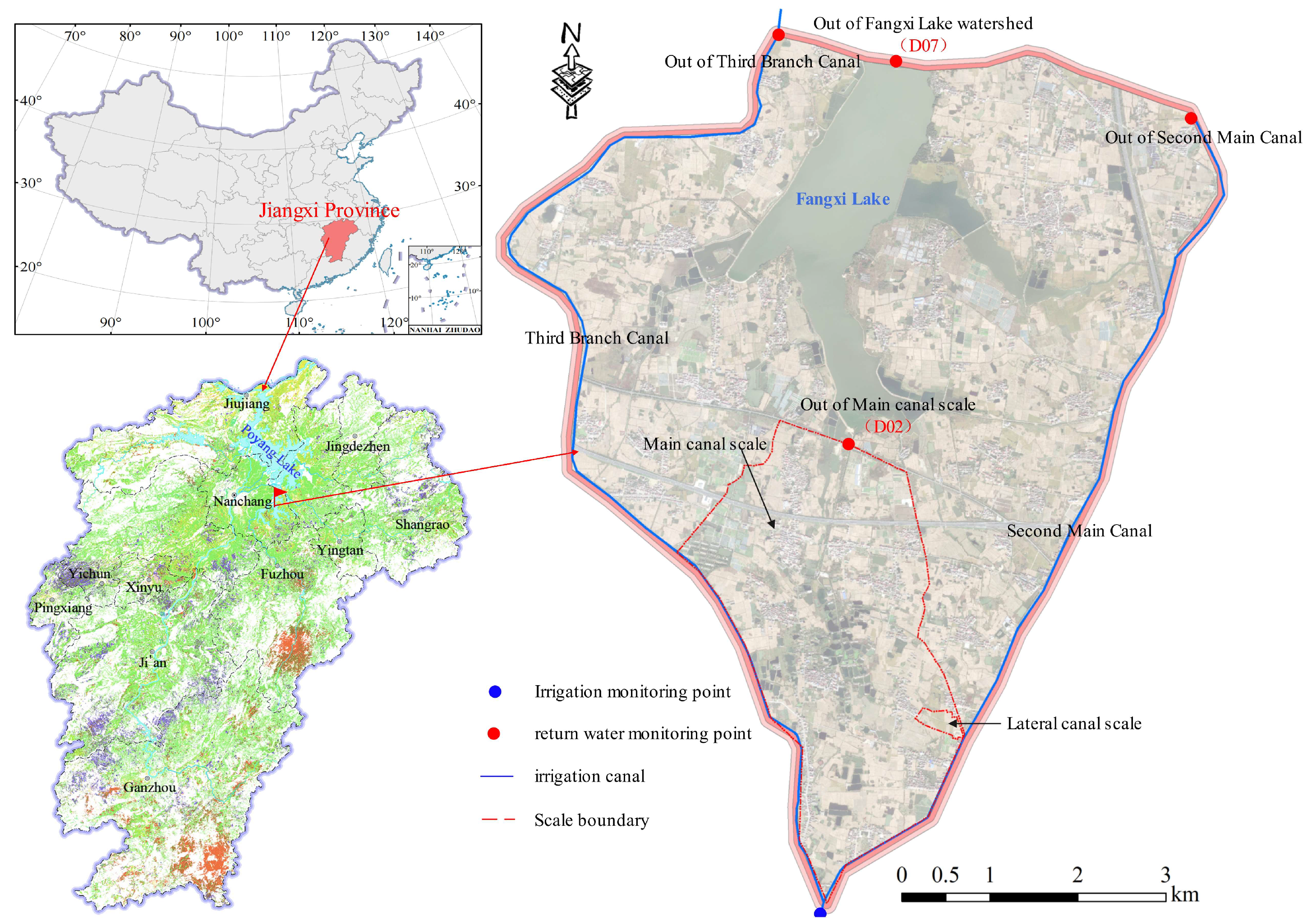
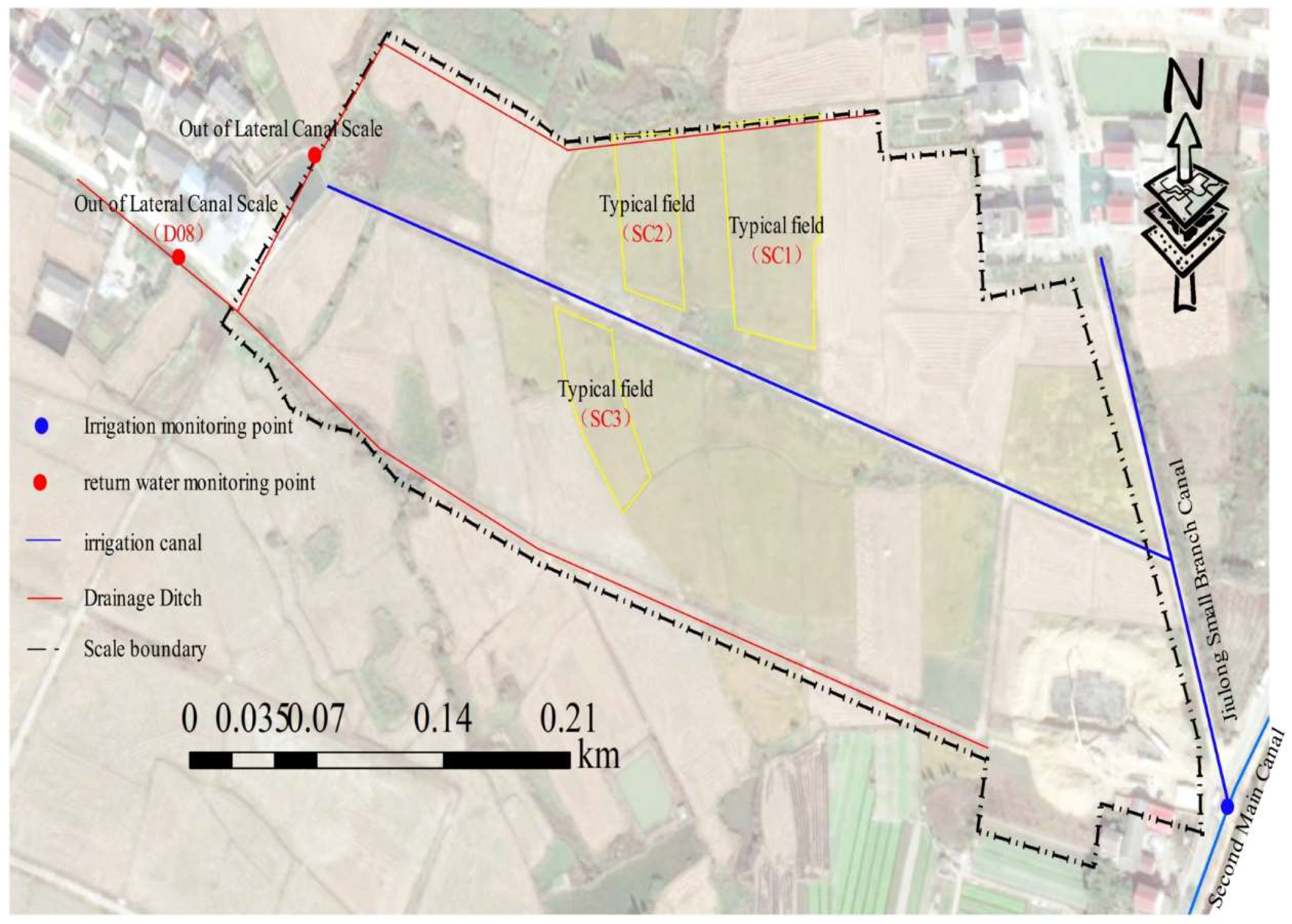
2.1. Experimental Site and Experimental Design

The Ganfu Plain Irrigation District (28°00′−28°40′ N, 115°31′−116°10′ E), a typical flatland irrigation district in Jiangxi Province, China, features intricate river networks across its 79,500 ha designed irrigated area. The Fangxi Lake watershed, characterized by its relatively closed and hierarchically nested multiscale system (Field→Lateral canal→Main canal→Small watershed), was selected as the experimental area within the Ganfu Plain Irrigation District (Figure 1). The study area experiences a subtropical monsoon climate, with an average annual precipitation of 1316.03 mm, mean temperature of 21.7 °C, and evaporation of 945.21 mm. Multiscale field observations of water balance components were conducted during the early and late rice growing seasons (May–October) in 2021 and 2022. The basic situation of each scale was as follows:
(1) The field scale (0.44 ha): This experimental unit comprised three designated paddies (SC1, SC2, SC3), two irrigation/drainage farm canals, and a pumping station abstracting water from the Second Main Canal for irrigation (Figure 2). Field drainage outputs were conveyed through the drainage ditches to the Lateral canal scale. The experimental plots’ water management and farming practices followed local farmers’ routines without experimental interventions.
(2) The lateral canal scale (56.13 ha): A relatively enclosed area near the headworks of the Jiulong Small Branch Canal was chosen as the study area for the lateral canal scale. The later canal scale primarily comprised two irrigation farm canals, one drainage farm canal, and one pond. Farmland drainage at this scale converged at monitoring node D08 and was subsequently conveyed via the river network to the main canal scale.
(3) The main canal scale (730.08 ha): The upstream section received farmland drainage from the later canal scale, while the downstream section connected to Fangxi Lake.
(4) The small watershed scale (Fangxi Lake watershed, 3320.16 ha): Bounded by the Second Main Canal and its Third Branch Canal, this small watershed routed farmland drainage through four main canals into Fangxi Lake, ultimately discharging at the only monitoring outlet D07.

2.2. Water Quantity Monitoring

2.2.1. Paddy Field Water Balance Monitoring

Paddy water balance was determined using the following equations:
W 2 = W 1 + P + I R R f i e l d E T c V i n D
where W 1 and W 2 are water storage capacity of paddy at the beginning and end of the period, respectively (mm). When a water layer is present in the field, the water storage capacity of the paddy field is determined as the sum of the water storage depth of the surface water layer and that of the root zone (converted based on soil moisture content and root zone depth). In the absence of a surface water layer, the water storage capacity corresponds solely to the water storage depth of the root zone; P is the precipitation (mm), I R R f i e l d is the irrigation volume (mm), E T c is the rice evapotranspiration (mm), V i n is the vertical infiltration (mm), and D is the drainage discharge (mm).
(1)
The irrigation volumes were calculated by converting the electricity consumption data from the pumping station.
I R R f i e l d = W C μ 3.6 P A 10 6
where I R R f i e l d is the irrigation water depth (mm); W is the total electricity consumption of the pump station (kWh), obtained from the State Grid Corporation of China and on-site records; P is the rated pump power (kW); μ is the pump efficiency, estimated by referring to pump performance curves; C is the rated flow rate (m3/s); and A is the irrigated area controlled by the pump station (m2), mainly determined through field surveys and aerial photography image maps.
The irrigation volumes were verified based on the changes of the field water storage capacity and drainage.
I R R f i e l d , i = W 1 , i     W 2 , i + S i
where W 1 , i and W 2 , i are the water storage capacity of a paddy at the beginning and end of the period, respectively (mm). The water depths of the paddy field and soil moisture contents of the root zone were automatically recorded by the HOBO (U20L-04) water level sensors and TDR installed in three typical fields (SC1, SC2, SC3), respectively. S i represents the field drainage volume during the period, calculated by converting the drainage volume at the lateral canal scale to the unit area (mm).
(2)
Field water consumption ( C w )
Simple lysimeters (bottomless buckets) were installed in three typical fields. Under conditions free from irrigation, rainfall, or drainage events, field water levels were monitored daily at 08:00 local time. C w was calculated using the consecutive-day water level difference. When irrigation, rainfall, and drainage occurred, C w was derived using field water balance equations.
(3)
Rice evapotranspiration ( E T c ):
The evapotranspiration for rice was determined based on data monitored by the Jiangxi Provincial Irrigation Experiment Centre Station, located near the study area. Additionally, the crop coefficient method was employed to validate and compare the monitored data.
E T c = K c × E T 0
E T 0 = 0.408 Δ ( R n G ) + γ [ 900 / ( T + 273 ) ] u 2 ( e s e a ) Δ + γ ( 1 + 0.34 u 2 )
where E T c is the daily rice evapotranspiration (mm/d); K c is crop coefficient (dimensionless); E T 0 is the reference evapotranspiration of cereal crops (mm/d); Δ is the slope of the saturation vapour pressure–temperature curve (kPa/°C); R n is the net radiation at the crop surface (MJ/m2/d); G is the soil heat flux density (MJ/m2/d); γ is the psychrometric constant (kPa/°C); T is the mean daily air temperature at 2 m height (°C); u 2 is the wind speed at 2 m height (m/s); e s is the saturation vapour pressure (kPa); and e a is the actual vapour pressure (kPa). Meteorological parameters T and u 2 were measured by automated weather stations, while G , γ , e s , e a , Δ , R n , and other variables were calculated according to methodologies recommended by the FAO.
(4)
Paddy vertical infiltration ( V i n )
Vertical infiltration was calculated as the difference between field water consumption and evapotranspiration.
(5)
Paddy drainage ( D ):
Paddy drainage was estimated by measuring pre- and post-drainage water levels. It was cross-validated with flow data from agricultural ditches and ponds at the farm canal, combined with irrigated area measurements.
D = H 0 + I R R f i e l d + P Cw H 1
where D is paddy drainage (mm), H 0 is the pre-drainage water depth (mm), I R R f i e l d is irrigation water depth (mm), P is the precipitation (mm), and H 1 is the post-drainage water depth (mm).
(6)
Meteorological data:
Precipitation data were recorded using rain gauges with an accuracy of 0.2 mm installed adjacent to experimental plots. Meteorological data, excluding precipitation, were obtained from the Jiangxi Provincial Irrigation Experiment Centre.

2.2.2. Lateral Canal Scale Water Monitoring

Drainage at the lateral canal scale was monitored using a Parshall flume and a water level observation well equipped with an HOBO (U20L-04) (D08), which was installed along the drainage canal. The drainage volumes were calculated using the Parshall flume flow conversion formula.

2.2.3. Main Canal Scale Water Monitoring

Flow and water level monitoring points were set up at the outlet (D02) of the main canal scale. The flow rate at this point was measured using a flow velocity and cross-section area method. Using the monitored water level data, a water level–flow relationship curve was established. For a rectangular cross-section canal, the rating curve equation takes the following form:
Q ( h ) = B h n B h B + 2 h 2 / 3 S 1 / 2
where Q is discharge (m3/s); h is water depth (m); B is canal width (m); n is Manning’s roughness coefficient (dimensionless); and S is energy slope (dimensionless).

2.2.4. Small Watershed Scale Water Monitoring

Upstream and downstream water level monitoring stations were established at the outlet of Fangxi Lake watershed (Point D07). Watershed-scale drainage volume was calculated using sluice gate hydraulic equations based on the total gate opening height and head difference between upstream and downstream water levels. During gate operations, flow regimes were classified as either free flow or submerged flow, with discharge calculated using broad-crested weir equations:
Free Discharge ( Q F D ):
Q FD = m B 2 g h 1 1.5
where Q F D is the free-flow discharge (m3/s); m is the free-flow coefficient (dimensionless), empirically set to 0.35; B is the gate opening width (m), measured on-site; g is the gravitational acceleration (9.81 m/s2); h 1 is the upstream water depth (m).
Submerged discharge ( Q S D ):
Q S D = ϕ B h 2 2 g ( H 1 H 2 )
where Q S D is the submerged-flow discharge (m3/s); ϕ is the submergence correction factor, empirically set to 1.09; H 1 and H 2 are the upstream and downstream water levels (m), respectively; h 2 is the downstream water depth (m).

2.3. Rice Growth Stages and Field Management

The rice cultivation method in the study area was direct seeding. The rice variety was HuangHuazhan. Early rice was harvested from late July to early August, while late rice was harvested in mid to late October. The growth stage divisions for the 2021–2022 rice seasons are summarized in Table 1. Due to COVID-19 restrictions in 2022, field monitoring was initiated after the early rice tillering stage, resulting in missing data for the seedling recovery phase. Fertilization and pesticide application regimes were aligned with conventional local farming practices.
The rainfall in the Fangxi Lake Watershed mainly occurred during the early rice growth period (Figure 3), and several heavy rainfall events occurred between May and July. Therefore, two typical rainfall processes were selected as examples to be analyzed, and the typical rainfall processes are shown in Table 2.

3. Results

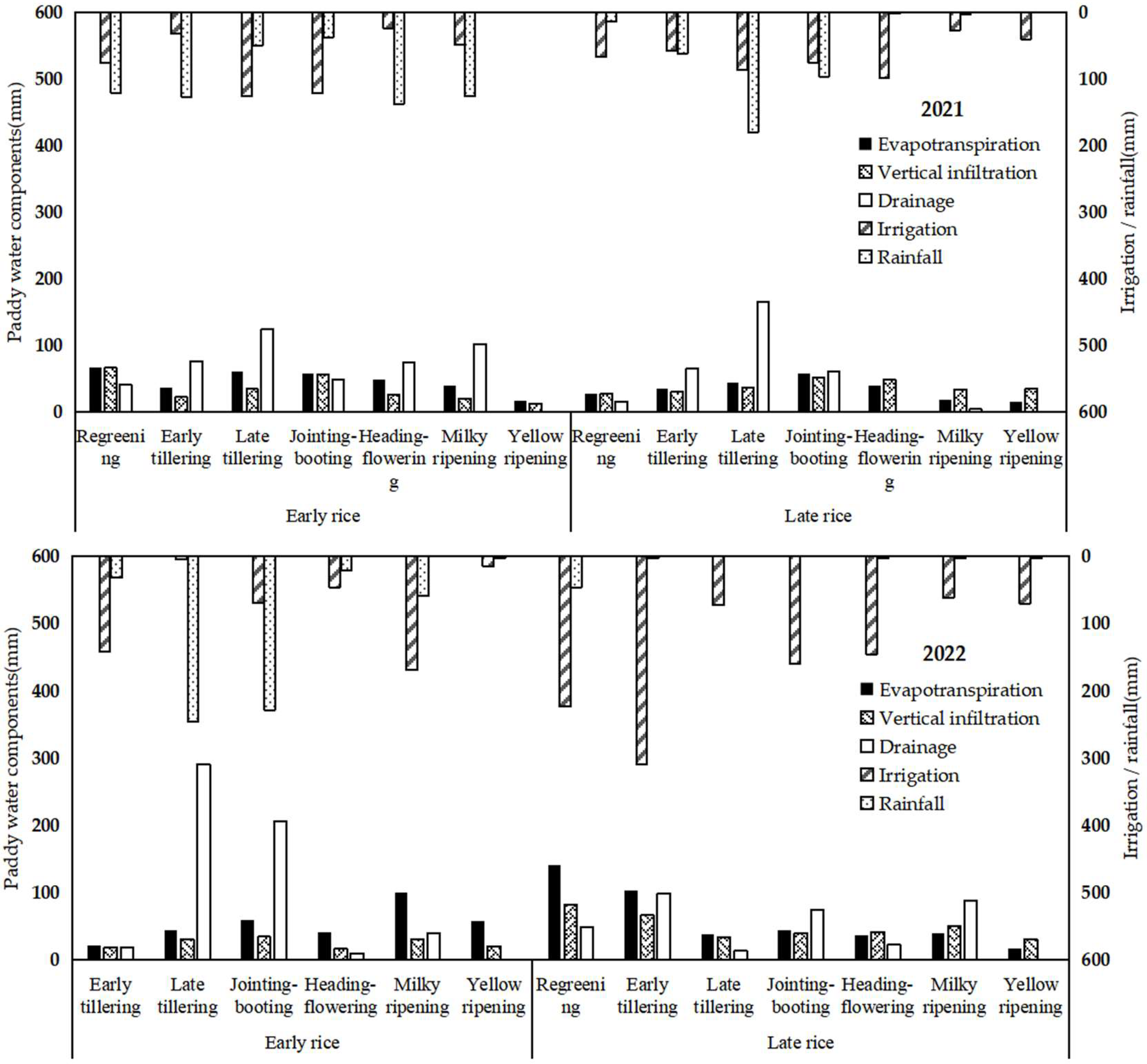
3.1. Paddy Field Water Cycle

From a dual-cropping rice system perspective, the annual averages, rainfall, irrigation, evapotranspiration, and drainage (surface drainage + vertical infiltration) were 952.9, 1186.3, 649.1, and 1332.7 mm, respectively, demonstrating approximate equilibrium between water inputs and outputs (Figure 4). Irrigation accounted for 42.4% and 78.5% of water input in early and late paddy fields. This disparity was associated with the overlap of early rice cultivation with the rainy season and the extreme drought conditions encountered in Jiangxi Province during the late rice growing period (July–November 2022). Drainage constituted the dominant water loss pathway, exceeding 65% of total outputs in both rice seasons, with surface drainage accounting for approximately 40%. The tillering stage emerged as a critical drainage period, with 49.5% and 52.2% of total drainage occurring during this phase in early and late rice, respectively, coinciding with relatively high rainfall levels. Post-tillering, irrigation inputs and evapotranspiration progressively increased with crop development, peaking during the jointing-booting stage. Water demand gradually decreased from the milky to yellow ripening stages.
The annual precipitation in 2021 exceeded that of 2022 by 47.6%, which primarily contributed to the pronounced interannual variability in irrigation water demand. Specifically, the irrigation volume for paddy fields in 2022 increased by 69.5% compared to 2021 levels. From the perspective of growing seasons, rainfall during the early rice season was nearly twofold higher compared to the late rice, corresponding to a 57.5% increase in paddy field drainage. Especially in 2022, rainfall was concentrated in the late tillering and jointing and booting stages of early rice, during which surface drainage accounted for 88.1% of the entire growth period.

3.2. Multiscale Water Cycle Processes

Drainage patterns in the experimental area exhibited significant scale effects (Figure 5). During the early rice growing season, drainage per unit area initially decreased with an increasing spatial scale, reached minimum values at the lateral canal scale, and then increased to peak levels at the Fangxi Lake watershed scale. Compared with field scale measurements, drainage volumes showed a 46.5% reduction at the lateral canal, a 6.1% reduction at the main canal, and a 20.0% increase at the small watershed scale. In contrast, late rice season drainage demonstrated a different scaling pattern: per-unit drainage declined with scale expansion until peaking at the main canal scale, then slightly decreased under the moderating effects of the Fangxi Lake watershed. Relative to the field scale, drainage was reduced by 28.7% at the lateral canal, increased by 43.0% at the main canal, and diminished by 62.8% at the small watershed scale.
Drainage patterns across spatial scales during different growth stages are shown in Table 3. At more minor scales (field plots and lateral canal), drainage volumes during the regreening, early tillering, and late tillering stages were 37.1% higher than those at larger scales (main canal and small watershed), a pattern associated with limited transpiration demands in early growth phases and rapid drainage responses to irrigation/rainfall inputs in more minor scales. Conversely, post-jointing-booting stages showed 103.6% greater drainage at larger scales than smaller units. This reversal reflects scale accumulation effects and the regulatory capacity of watershed systems, exhibiting lagged drainage responses.

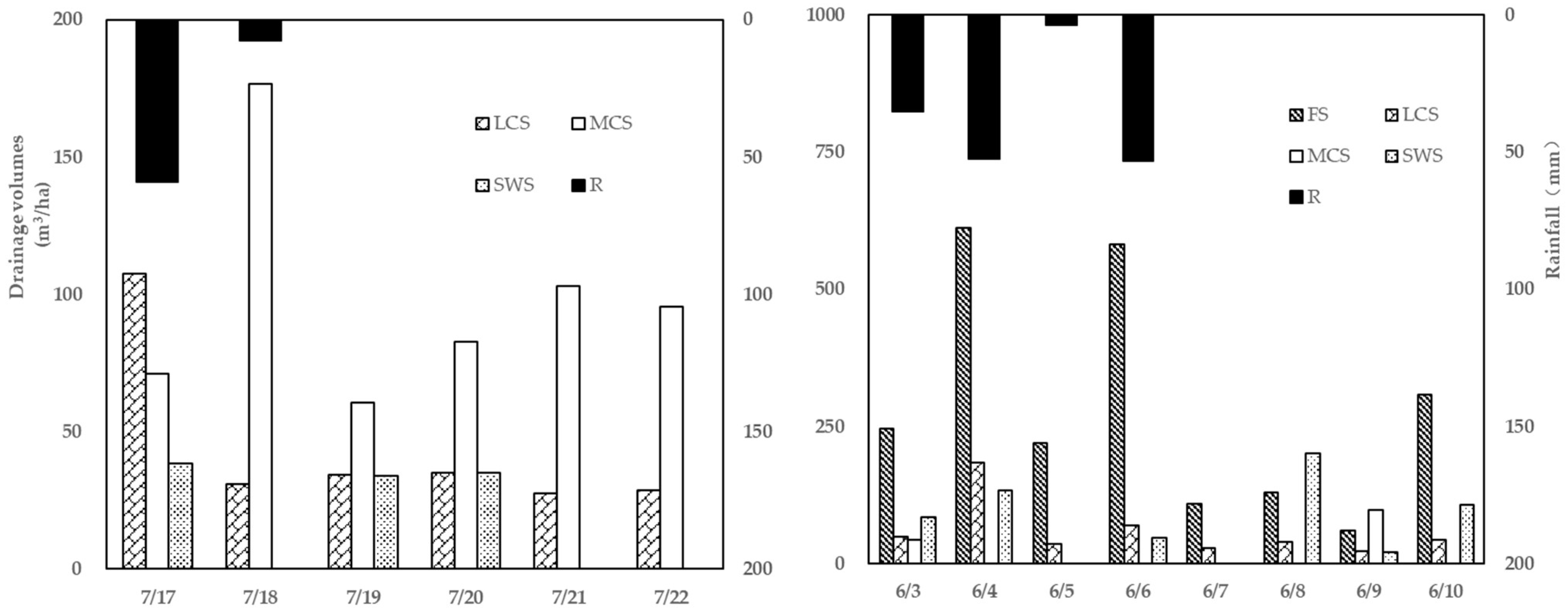
3.3. Multiscale Drainage Variations Under Typical Rainfall Events

Comparative analysis of two representative rainfall-drainage patterns (short-duration rainfall monitoring period: 17–22 July 2021; sustained rainfall monitoring period: 3–10 June 2022) revealed distinct multiscale drainage dynamics (Figure 6). The short-duration rainfall events of 2021 occurred during the early rice yellow ripening and late rice seedling recovery stages. No field-scale drainage occurred with low initial soil moisture and water retention requirements for late rice establishment. Drainage was predominantly concentrated at the lateral canal and main canal scales, peaking at the lateral ditch scale on the rainfall day and reaching maximum values at the main canal scale the following day. Following the high-intensity rainfall event (59.0 mm/d), drainage at the main and lateral canals persistently exceeded watershed-scale levels, demonstrating rapid hydrological responses at intermediate scales to short-duration rainfall events.
In contrast, the 2022 sustained rainfall event during early rice late tillering stages triggered soil saturation and extended drainage demands. Field and lateral canal drainage persisted at high magnitudes throughout the event, peaking at 2270.20 m3/ha on the field scale. Notably, drainage exhibited a declining trend with the increasing spatial scale, decreasing 73.8% from the field to watershed scales. This attenuation reflected intermittent interruptions and lagged cumulative drainage effects in larger systems (main canal/watershed), attributable to discontinuous water inputs from upstream small-scale networks.

3.4. Multiscale Return Flow and Reuse Efficiency

The utilizable return flow in the irrigation district exhibited a nonlinear pattern with increasing spatial scale, initially decreasing from lateral to main canal scales, then rising at the watershed scale. Field-to-lateral canal systems emerged as critical reuse zones, achieving return flow reuse efficiencies of 17.7–70.1% and 10.3–77.7% during early and late rice seasons, respectively (Table 4). Reuse between the lateral canal and the main canal occurred only during the early growth stages of the early rice and late rice regreening stages, with no measurable reuse in other growth phases. The majority of upstream drainage cannot be directly reused for downstream farmland irrigation due to topographic constraints. Instead, these water fluxes are discharged through drainage channels to the watershed outlet (Fangxi Lake). Return flow reuse efficiency peaked at the main canal to watershed scales, with a mean efficiency of 60.0%. Since the late tillering stage of early rice, return flow from field plots to the lateral canal was twice as high as that of late rice, likely associated with concentrated rainfall and elevated drainage demands during early rice growth phases. In contrast, return flow reuse efficiency at the main canal to small watershed scale was significantly higher during late rice maturation, reaching full recycling (100%) of main canal drainage. This operational shift was driven by strategic water management; canal headworks ceased water releases. At the same time, the Fangxi Lake watershed initiated storage operations to secure water reserves for spring irrigation needs.

4. Discussion

4.1. Irrigation-Rainfall Influences on Paddy Water Cycling

Irrigation and rainfall affect the water cycle in paddy fields [16,17]. The irrigation-ET linkage likely reflects farmers’ adaptive practices of increasing water inputs during peak ET phases (e.g., jointing-booting stages). Notably, irrigation contributed 42.4% and 78.5% to total water inputs in early and late rice seasons, respectively, highlighting climate-driven amplification of irrigation demands under extreme droughts [18,19]. The observational results from rice paddy field experiments in the Gaoyou Irrigation District, Jiangsu Province [20,21] consistently indicated that rainfall is a critical factor triggering field drainage. In the study area, rainfall is predominantly concentrated between May and June, coinciding with the rice tillering stage when crop water demand remains relatively low. This concentration leads to the conversion of most precipitation into surface runoff, which is subsequently discharged. Notably, drainage volume was at a high level during the tillering stage across all four rice-growing seasons, with early and late rice accounting for 49.5% and 52.2% of the total drainage volume, respectively. Previous studies have demonstrated that heavy rainfall during the rice-growing season, combined with supplementary irrigation, contributes to substantial drainage volumes. The resulting nitrogen and phosphorus losses have become a major source of regional non-point source pollution [22,23,24]. Therefore, strategic irrigation and drainage management regulation during the tillering stage is critical to mitigate nitrogen and phosphorus contamination risks.

4.2. Characteristics of Multiscale Drainage Processes

This study revealed significant scale effects and characteristics of drainage patterns across irrigation district scales. During the early rice season, drainage per unit area exhibited a “decrease-increase” trend with spatial upscaling, whereas late rice showed “decrease-peak-decline” dynamics (Figure 5). This divergence is linked to spatial heterogeneity in hydrological connectivity and return flow reuse efficiencies [25]. For instance, the 46.5% reduction in drainage from field to lateral canal scales during early rice may stem from preferential water uptake via crop transpiration and soil infiltration at more minor scales. Conversely, increased watershed-scale drainage reflects cumulative return flow effects and enhanced hydraulic linkages in canal networks. Distinct drainage patterns emerged under contrasting rainfall regimes (Figure 6): intense short-duration rainfall triggered rapid drainage responses at the lateral/main canal scales but limited interception capacity at mesoscales, necessitating engineered interventions (e.g., pond-retention systems) to enhance return flow utilization. Prolonged rainfall events sustained field-scale drainage outputs yet reduced small watershed-scale drainage by 73.8% due to regulatory storage effects. These findings align with observations of persistent drainage [26].
Growth-stage comparisons (Table 3) showed 37.1% higher drainage at small scales (field/lateral canal) during regreening and tillering stages driven by low transpiration demands and rapid drainage responses under saturated soil conditions. Post-jointing-booting stages reversed this pattern, with 103.6% greater drainage at larger scales—a consequence of cumulative effects and watershed regulatory capacity: (1) multi-level canal routing delays causing lagged drainage and (2) Hydrological redistribution via ponds and wetlands, which attenuated peak flows through storage-buffer functions [27].

4.3. Optimization Pathways for Return Flow Reuse

This study revealed scale-dependent characteristics and growth-stage variations in return flow reuse efficiency within the irrigation district. Current practices primarily rely on structural controls (e.g., terminal drainage ditches and Fangxi Lake interception) to capture agricultural return flows. Field-to-lateral canal systems emerged as core reuse zones, achieving efficiencies of 17.7–70.1% (early rice) and 10.3–77.7% (late rice), consistent with the 80.86% reuse rate observed in hilly southern irrigation systems where channels dominate return flow recycling [28]. At the main canal and small watershed scale, the mean return flow reuse efficiency reached 60.0%, peaking at 100% during late rice maturation through Fangxi Lake’s hydraulic regulation, demonstrating effective water resource reallocation. However, geomorphic constraints in the study area limited the utilization efficiency between lateral canal and main canal scales to an average of 15.4%. Previous studies have demonstrated that implementing control gates for main canals can effectively regulate drainage and water storage in plain areas [29]. To enhance return flow reuse and improve water use efficiency, this study proposes the implementation of additional control gates or the regulation of ponding storage within the lateral-main ditch network.

5. Conclusions

Through in situ experimental monitoring across four rice-growing seasons (2021–2022), this study summarized paddy water cycle mechanisms in plain irrigation districts, the multiscale drainage characteristics of paddies, and the scale effects of return flow utilization. In addition, strategies were proposed to reduce drainage discharge and enhance return flow reuse efficiency in plain irrigation districts.
Paddy water cycling was influenced by irrigation and rainfall. Under limited rainfall conditions, irrigation contributed 78.5% of the total water input during the late rice season. Rainfall emerged as the dominant trigger for field drainage, with peak precipitation occurring during the tillering stage (May–June) in the study area. Drainage volumes during this critical phase accounted for 49.5–52.2% of the total, underscoring the urgency of prioritizing controlled irrigation and drainage strategies specifically tailored to the tillering stage. Characteristics of multiscale drainage manifested as an “initial decrease followed by increase” pattern in early rice versus a “decrease-peak-decline” trend in late rice. Growth-stage disparities were governed by canal convergence hysteresis and pond regulation effects: small-scale (field/lateral canal) drainage exceeded larger scales by 37.1% during the regreening and tillering stages. In comparison, post-jointing-booting stages saw 103.6% greater drainage at large scales (main canal/small watershed).
Field to lateral canal scales emerged as core zones for return flow reuse (up to 77.7% efficiency). At the lateral to main canal scales, the low return flow utilization efficiency could be improved through the installation of additional control gates or the regulation of ponding storage. The storage regulation of Fangxi Lake has enabled highly efficient water resource utilization. At the main canal to small watershed scales, this regulation achieved 60.0% mean reuse efficiency, reaching full reuse (100%) during late rice maturation.
We propose an integrated optimization framework comprising tillering-stage controlled irrigation/drainage, multiscale hydraulic interception through control gates and detention ponds across lateral/main canal systems, and dynamic watershed storage scheduling synchronized with rainfall forecasts and crop water demand. This strategy could mitigate multiscale drainage losses and enhance water use efficiency in plain irrigation districts.

Author Contributions

Conceptualization, F.L. and J.Z.; methodology, J.Z., Y.X. and P.J.; investigation, J.Z., P.J. and N.Y.; data curation, J.Z.; writing—original draft preparation, J.Z. and Y.X.; writing—review and editing, F.L. All authors have read and agreed to the published version of the manuscript.

Funding

This research was funded by Jiangxi Province’s “Technology and water conservancy” Joint Plan Project, grant number 2022KSG01005, and by Water Conservancy Science and Technology Projects in Jiangxi Province, grant number 202324YBKT15.

Institutional Review Board Statement

Not applicable.

Data Availability Statement

Data is contained within the article.

Conflicts of Interest

The authors declare no conflicts of interest.

References

  1. Srivastav, A.L.; Dhyani, R.; Ranjan, M.; Madhav, S.; Sillanpää, M. Climate-resilient strategies for sustainable management of water resources and agriculture. Environ. Sci. Pollut. Res. 2021, 28, 41576–41595. [Google Scholar] [CrossRef] [PubMed]
  2. Chen, L.; Chang, J.; Wang, Y.; Guo, A.; Liu, Y.; Wang, Q.; Zhu, Y.; Zhang, Y.; Xie, Z. Disclosing the future food security risk of China based on crop production and water scarcity under diverse socioeconomic and climate scenarios. Sci. Total Environ. 2021, 790, 148110. [Google Scholar] [CrossRef] [PubMed]
  3. Ofori, S.A.; Cobbina, S.; Obiri, S. Climate change, land, water, and food security: Perspectives from Sub-Saharan Africa. Front. Sustain. Food Syst. 2021, 5, 680924. [Google Scholar] [CrossRef]
  4. Liang, F.; Li, S.; Jie, F.; Ge, Y.; Liu, N.; Jia, G. The Development of a Coupled Soil Water Assessment Tool-MODFLOW Model for Studying the Impact of Irrigation on a Regional Water Cycle. Water 2023, 15, 3542. [Google Scholar] [CrossRef]
  5. Hao, S.N.; Li, X.Y.; Du, X.Z.; Zhang, W.S. A Review on Non-Point Source Nutrient Pollution of Irrigation Plain Areas. Ecol. Environ. Sci. 2015, 24, 1235–1244. [Google Scholar]
  6. Schulze, R. Transcending scales of space and time in impact studies of climate and climate change on agrohydrologicalresponses. Agric. Ecosyst. Environ. 2000, 82, 185–212. [Google Scholar] [CrossRef]
  7. Wu, Z.; Rao, W.; Zheng, F.; Zhang, C.; Li, T. Pollution source identification of nitrogen and phosphorus in the lower West Main Canal, the Ganfu Plain irrigation district (South China). Environ. Monit. Assess. 2023, 195, 1011. [Google Scholar] [CrossRef]
  8. Feng, Z.; Miao, Q.; Shi, H.; Feng, W.; Li, X.; Yan, J.; Liu, M.; Sun, W.; Dai, L.; Liu, J. Simulation of Water Balance and Irrigation Strategy of Typical Sand-Layered Farmland in the Hetao Irrigation District, China. Agric. Water Manag. 2023, 280, 108236. [Google Scholar] [CrossRef]
  9. Wang, Y.; Cai, H.; Yu, L.; Peng, X.; Xu, J.; Wang, X. Evapotranspiration Partitioning and Crop Coefficient of Maize in Dry Semi-Humid Climate Regime. Agric. Water Manag. 2020, 236, 106164. [Google Scholar] [CrossRef]
  10. Tong, C.; He, R.; Wang, J.; Zheng, H. Study on Water and Salt Transport Characteristics of Sunflowers under Different Irrigation Amounts in the Yellow River Irrigation Area. Agronomy 2024, 14, 1058. [Google Scholar] [CrossRef]
  11. Henry, A.; Wehler, R.; Grondin, A.; Franke, R.; Quintana, M. Environmental and Physiological Effects on Grouping of Drought-Tolerant and Susceptible Rice Varieties Related to Rice (Oryza Sativa) Root Hydraulics under Drought. Ann. Bot. 2016, 118, 711–724. [Google Scholar] [CrossRef] [PubMed]
  12. Dai, J.; Cui, Y.; Cai, X.; Brown, L.C.; Shang, Y. Influence of water management on the water cycle in a small watershed irrigation system based on a distributed hydrologic model. Agric. Water Manag. 2016, 174, 52–60. [Google Scholar] [CrossRef]
  13. Wu, D.; Cui, Y.; Wang, Y.; Chen, M.; Luo, Y.; Zhang, L. Reuse of return flows and its scale effect in irrigation systems based on modified SWAT model. Agric. Water Manag. 2019, 213, 280–288. [Google Scholar] [CrossRef]
  14. Li, Q.F.; Chen, C.M.; Li, D.X.; Cai, C.K.; Wang, S.W. Research on the calculation method of multi-scale irrigation water use in the irrigation system of plain river network based on system dynamics. China Rural Water Hydropower 2024, 1, 25–29+36. [Google Scholar]
  15. Wang, S.; Wang, C.; Zhang, C.; Xue, J.; Wang, P.; Wang, X.; Huo, Z. A classification-based spatiotemporal adaptive fusion model for the evaluation of remotely sensed evapotranspiration in heterogeneous irrigated agricultural area. Remote Sens. Environ. 2022, 273, 112962. [Google Scholar] [CrossRef]
  16. Xu, B.; Shao, D.; Fang, L.; Yang, X.; Chen, S.; Gu, W. Modelling Percolation and Lateral Seepage in a Paddy Field-Bund Landscape with a Shallow Groundwater Table. Agric. Water Manag. 2019, 214, 87–96. [Google Scholar] [CrossRef]
  17. Hama, T.; Nakamura, K.; Kawashima, S.; Kaneki, R.; Mitsuno, T. Effects of Cyclic Irrigation on Water and Nitrogen Mass Balances in a Paddy Field. Ecol. Eng. 2011, 37, 1563–1566. [Google Scholar] [CrossRef]
  18. Fanta, F.J. Impacts of Climate Variability on the Yield of Major Food Crops in the Gambia: Implications for Food Security. Ph.D. Thesis, Chinese Academy of Agricultural Sciences, Beijing, China, 2022. [Google Scholar]
  19. Cao, Y.; Zhang, Y.; Tian, J.; Li, X.; Tang, Z.; Yang, X.; Zhang, X.; Ma, N. Strong agricultural resilience to 2022 Southern China drought. Earth’s Future 2024, 12, e2023EF004243. [Google Scholar] [CrossRef]
  20. Liu, F.L.; Xiong, Y.J.; Fan, L.; Shao, P.Y. Characteristics and influencing factors of rainfall-runoff in rice irrigation district. China Rural Water Hydropower 2022, 5, 95–100. [Google Scholar]
  21. Yu, Y.; Xu, J.; Zhang, P.; Meng, Y.; Xiong, Y. Controlled irrigation and drainage reduce rainfall runoff and nitrogen loss in paddy fields. Int. J. Environ. Res. Public Health 2021, 18, 3348. [Google Scholar] [CrossRef]
  22. Li, Y.W.; Xu, J.Z.; Liu, W.H. Characteristics of water and nitrogen loss under subsurface pipe-open ditch controlled drainage in paddy fields. Trans. CSAE 2021, 37, 113–121. [Google Scholar]
  23. Li, J.Q.; Wang, Y.; Chen, X.D.; Fei, B.Y.; Guo, B.; Liu, C.; Li, H. The coupled effect of precipitation and fertilization on nitrogen loss via surface runoff from paddy fields. J. Irrig. Drain. 2023, 42, 39–45. [Google Scholar]
  24. Wang, X.X.; Zuo, T.; Wang, X.J.; Huang, S.; Wang, J.; Leng, M.Z.; Ni, W.Z. Comparative of two fertilization modes on crop yields and nitrogen/phosphorus runoff losses under rice-wheat rotation. J. Soil Water Conserv. 2020, 34, 20–27. [Google Scholar]
  25. Chen, H.R.; Huang, J.S.; Wu, J.W. Review of scale effect on the irrigation water use efficiency. Adv. Water Sci. 2011, 22, 872–880. [Google Scholar]
  26. Meng, Y.; Yu, Y.; Yu, S.; Zhang, P.; Xiong, Y. Simulation of Drainage Volume and Nitrogen Loss Load in Paddy Fields under Different Irrigation and Drainage Modes and Hydrological Years. Agronomy 2024, 14, 1095. [Google Scholar] [CrossRef]
  27. Dai, J.F.; Cui, Y.L. Distributed hydrological model for irrigation area based on SWAT I. Principle and method. J. Hydraul. 2009, 40, 145–152. [Google Scholar]
  28. Shao, P.Y.; Xiong, Y.J.; Yuan, N.N.; Peng, Z.Y.; Li, Y.L.; Su, P.L.; Wei, G.F.; Ye, L.; Lin, X.W. Hydrological cycle for Paddy-Ponds-Ditches system and reuse of return flow in Southern hilly irrigated areas. Trans. Chin. Soc. Agric. Eng. 2023, 39, 106–117. [Google Scholar]
  29. Shen, T.; Shen, R.; Yu, F.C. Optimization of the Control Scheme for the Main Drainage and Storage Based on MIKE Model. China Rural Water Hydropower 2022, 12, 156–161. [Google Scholar]
Figure 1. Geographical location of the study area and spatial layout of multiscale experimental zones.
Agriculture 15 01178 g001
Figure 2. Monitoring layout in field and lateral canal systems.
Agriculture 15 01178 g002
Figure 3. Rainfall in the Study Area, 2021 and 2022.
Agriculture 15 01178 g003
Figure 4. The water balance components of early and late rice paddy fields in 2021–2022.
Agriculture 15 01178 g004
Figure 5. Drainage per unit area at different spatial scales: FS is the field scale (0.56 ha), LCS is the lateral canal scale (56.13 ha), MCS is the main canal scale (730.08 ha), and SWS is the small watershed (3320.16 ha).
Agriculture 15 01178 g005
Figure 6. Multiscale drainage dynamics under typical rainfall events: Field scale (FS), Lateral canal scale (LCS), Main canal scale (MCS), Small watershed scale (SWS), and Rainfall (R).
Agriculture 15 01178 g006
Table 1. Rice growth stage classification.
YearRice ReasonRegreeningEarly TilleringLate Tillering Jointing-Booting Heading FloweringMilky RipeningYellow Ripening
2021Early rice4/3~5/55/6~5/165/17~6/26/3~6/186/19~6/307/1~7/107/11~7/16
Late rice7/19~8/198/20~8/298/30~9/59/6~9/159/16~9/259/26~10/510/6~10/13
2022Early rice-5/19~5/275/28~6/116/12~6/286/29~7/67/7~7/167/17~7/31
Late rice7/18~8/138/14~9/39/4~9/149/15~9/279/28~10/1210/13~10/2910/30~11/8
Table 2. Typical rainfall processes.
YearDatePrecipitation (mm)Duration (d)Intestine (mm/d)
20217/18~7/2566.60233.30
20226/3~6/10145.00436.25
Table 3. Drainage volumes across growth stages and spatial scales.
Rice ReasonGrowth StagesField ScaleLateral Canal ScaleMain Canal ScaleSmall Watershed Scale
20212022202120222021202220212022
Early riceRegreening406-334-130-0-
Early tillering755180470257865850112
Late tillering124529034807603201968521205
Jointing-booting484205339890932051421654935
Heading-flowering741952972715406291525884
Milky ripening1020394171275152663483646
Yellow ripening0008774355880380
Late riceRegreening151482116282503069194
Early tillering649982366324881178321738
Late tillering164612823216377911319650
Jointing-booting607737289250129713179400
Heading-flowering02203324131177110500
Milky ripening37883330496096400
Yellow ripening000212051600
Table 4. Multiscale agricultural return flow and its utilization efficiency.
Rice ReasonGrowth StagesField—Lateral ScaleLateral—Main ScaleLateral—Small Watershed Scale
MAURFRFUEMAURFRFUEMAURFRFUE
Early riceRegreening405.717.7334.061.2129.8100.0
Early tillering467.122.1363.9/474.788.2
Late tillering2074.170.1620.258.4258.0/
Jointing-booting1268.448.5653.536.2416.8/
Heading-flowering418.132.2283.6/584.8/
Milky ripening707.268.5223.1/407.3/
Yellow ripening0.0/438.5/2617.799.3
Late riceRegreening316.20.0622.159.6251.447.6
Early tillering815.857.7345.2/1332.190.4
Late tillering886.977.7197.5/954.849.5
Jointing-booting672.359.9269.3/1306.864.0
Heading-flowering109.8/372.8/1141.0100.0
Milky ripening460.110.3412.8/481.8100.0
Yellow ripening0.0/106.0/258.0100.0
MAURF (m3/ha), mean annual utilizable return flow volume; RFUE (%), return flow utilization efficiency.
Disclaimer/Publisher’s Note: The statements, opinions and data contained in all publications are solely those of the individual author(s) and contributor(s) and not of MDPI and/or the editor(s). MDPI and/or the editor(s) disclaim responsibility for any injury to people or property resulting from any ideas, methods, instructions or products referred to in the content.

