Article

Soil Erosion in Taiwan

Department of Civil Engineering, National Taipei University of Technology, Taipei 10608, Taiwan
*
Author to whom correspondence should be addressed.
Agriculture 2023, 13(10), 1945; https://doi.org/10.3390/agriculture13101945
Submission received: 25 August 2023 / Revised: 3 October 2023 / Accepted: 3 October 2023 / Published: 5 October 2023
(This article belongs to the Section Agricultural Soils)

Abstract

:
Soil erosion is a complex process involving material detachment, transportation (mainly by water, occasionally by wind), and eventual deposition when energy wanes. Human activities like tillage and construction can exacerbate soil erosion. Various forms of water erosion, such as sheet erosion, pedestal erosion, rills, piping, and gullying, are recognized. This pioneering study aims to comprehensively model water erosion across Taiwan at a 20 m spatial resolution, a departure from previous research focusing on smaller scales. Using the Revised Universal Soil Loss Equation (RUSLE) model, it seeks to examine the significant issue of soil erosion in Taiwan beyond agricultural areas and enable cross-regional comparisons. A large number of stations and the most recent data were used to establish the distributions of the rainfall runoff erosivity factor and the soil erodibility factor. In addition, we used the Google Earth Engine (GEE) to calculate the Normalized Difference Vegetation Index (NDVI) and a locally derived empirical equation to compute the cover-management factor. The topographic factor was determined using the System for Automated Geoscientific Analyses (SAGA). The support practice factor was analyzed using two different methods using datasets on World Urban Areas and Global Urban Boundaries from the literature. The analysis showed that despite the difference in the support practice factor, Taiwan’s resulting average yearly soil erosion rates are very similar (200.7 Mg ha−1 year−1 and 207.4 Mg ha−1 year−1). The amounts were validated against five watersheds that were instrumented with erosion pins. With prediction ratios ranging from 1.04 to 1.82 across four of the five watersheds, our findings provide empirical support for the alignment of our model with soil erosion pin measurements, especially within the Tsengwen reservoir watershed. However, it is noteworthy that these results also exhibit a tendency towards conservative estimations in the remaining watersheds. Our calculated estimate, falling within the range of 201–207 Mg ha−1 year−1, plausibly represents the upper limit of mean soil erosion in Taiwan. This assertion is predicated on the deliberate omission of local soil conservation measures from our study, a decision necessitated by the absence of comprehensive and detailed island-wide data. Despite this limitation, our results instill confidence in the robustness of our methodological approach, thereby suggesting that our estimation of soil erosion in Taiwan provides a reliable approximation.

1. Introduction

The erosion of soil is the wearing away of soil by wind or water. It can be brought about by both natural and human-made processes. As examples, natural processes encompass phenomena such as earthquakes and forest fires, both of which can either dislodge soil particles or strip away the protective vegetative cover, thereby facilitating erosion. In contrast, human-induced processes involve agricultural practices like continuous farming (tillage) without crop rotation and the excessive grazing of cattle on sloped terrain. Soil erosion is a global problem because it causes land degradation, reservoir siltation, and water supply issues, and it is frequently associated with flooding and landslides. It also contributes to sediment pollution and river sedimentation. These events significantly affect people’s lives, such as by making it difficult to grow crops or causing illness from drinking contaminated water.
Between 1877 and 1895, the German soil scientist Wollny conducted the first scientific erosion analysis, but the United States of America took the lead in soil erosion research afterward [1]. As a consequence of the US Department of Agriculture’s efforts, the Universal Soil Loss Equation (USLE) and the Revised Universal Soil Loss Equation (RUSLE) were proposed for studying water erosion [2,3,4]. To date, models based on the (R)USLE family are the most extensively used soil erosion models in the world, accounting for 41% of the Global Applications of Soil Erosion Modelling Tracker (GASEMT) database [5].
According to the GASEMT database [5], watershed-scale soil erosion studies account for the majority of entries (59%) in the database. In contrast, national-scale or equivalent studies, which include both wind and water erosion, account for only 2% of the studies [5]. Only Albania, Argentina, Australia, Brunei, China, Czechia, El Salvador, Ethiopia, Georgia, Germany, Hungary, India, Italy, Mauritius, New Zealand, the Palestinian Territories, Russia, Slovakia, South Africa, South Korea, Switzerland, and the United States have been researched. As a result, our grasp of the erosion problem at the national level is limited. We do not know how the soil erosion problem may be scaled from the watershed level to the national level, nor if the methodology used at the watershed level is appropriate at the national level. In Taiwan, the situation is similar. The majority of studies were conducted on plot-to-watershed scales [6,7,8,9,10,11,12,13,14,15,16,17,18,19,20,21,22,23,24]. There was just one simplified analysis of island-wide soil erosion, which was part of an “emergy” evaluation to investigate the environmental impact of changing the agriculture production system [25]. However, the study only analyzed agricultural areas; it did not accurately evaluate erosion factors, and it assumed that the slope length everywhere was uniformly 40 m.
Soil erosion is a complex process that encompasses three distinct stages: the initial detachment of material, its subsequent transportation (primarily by water but also by wind), and its eventual deposition when the available energy becomes insufficient for further transport. Additionally, human activities such as tillage and construction can induce soil erosion. For example, Weil and Brady [26] contend that in the case of tilled crop fields, the very process of tillage itself acts as a pivotal third factor contributing to erosion. Furthermore, Lee and Charman [27] emphasize the substantial sediment yields during construction, which can exceed those originating from undisturbed forested areas by up to 2000 times. Furthermore, various activities capable of undermining soil’s structural resilience, thereby increasing its susceptibility to erosive phenomena, encompass a diverse range of practices, including overgrazing, channelization, and urbanization. Additionally, factors such as deforestation, land use alterations, slope and topography shifts, and modifications in soil type and composition are recognized as significant contributors to this phenomenon. Soil management practices, exemplified by plowing, irrigation, and grading, exert a discernible influence on the transport of soil particles within ecosystems, thereby exacerbating erosion dynamics. Nonetheless, it is essential to note that water erosion remains associated with practices such as tillage agriculture, deforestation, and improper grazing on sloping lands within regions characterized by a humid to semi-arid climate [26].
A diverse array of water erosion types and forms can be identified, including sheet erosion, pedestal erosion, rills, piping, and gullying. Moreover, badlands can emerge as a consequence of a combination of piping, collapse, and gullying processes [27]. Given that water erosion is the predominant form of soil erosion in Taiwan, this study aims to extend soil erosion modeling beyond local watersheds to encompass the entirety of the island of Taiwan. Notably, this research is not confined solely to agricultural areas but encompasses all natural terrains beyond the city boundaries. Utilizing the RUSLE model, which predicts general soil loss resulting from rain splash and runoff, this research seeks to study the critical nature of soil erosion in Taiwan and facilitate future comparisons with other countries and regions.

2. Materials and Methods

According to the GASEMT database, national-level studies or equivalent have only been conducted in certain countries or territories. Because of the scale of analysis, the majority of these studies used the USLE-based approach in their investigation. As a result, this study will use RUSLE to model soil erosion (water erosion) in Taiwan.

2.1. Study Area

Taiwan is an East-Asian Island located in the western Pacific Ocean, approximately 160 km from the coast of southeastern China (Figure 1). It measures approximately 395 km (north-south) in length and 145 km (at its widest point) in width [28]. Currently, the central government (Republic of China, ROC) is headquartered in Taipei. In this study, we will only consider Taiwan Island and not the outlying islands and other political territories that the government of Taiwan (ROC) possesses or claims.
Taiwan’s geographical location is an essential factor contributing to the significance of soil erosion studies on the island. Since Taiwan has some of the most severe soil erosion in the world [29], these studies are crucial. Studies have shown that the type and amount of precipitation impact soil erosion. Heavy rain in the tropics does significantly more damage than gentle rain in temperate climate zones. The destructive rain zone is roughly bounded by latitudes 40 degrees north and south [1]. Taiwan sits between the northern latitudes of 25.3° and 21.9°, in the destructive rain zone. However, the northern region of Taiwan has a subtropical climate, while the southern part has a tropical one. The summer season lasts from April or May and ends in September or October. The winters are brief and not too cold, and the mountains receive occasional snowfall. The average annual high temperature on the island is 21 °C. Based on a 60-year dataset (1949–2009), Taiwan experiences substantial annual precipitation, totaling 2502 mm. Generally, the northern region (2932 mm) receives more rainfall compared to the southern (2521 mm), eastern (2543 mm), and central (2154 mm) areas, as reported by the government [30]. The monthly pattern follows a bell curve, with rainfall increasing from under 100 mm in January to over 400 mm in August and then decreasing to less than 100 mm in December. The period from May to October contributes to 78% of the annual rainfall.
Over the past four decades (1982–2021), January and February (JF) rainfall exhibited a decreasing trend, but in 2022, it notably increased to its third-highest recorded value. This rise results from both increased rainfall frequency and intensity. Further analysis reveals that the elevated JF 2022 rainfall is primarily associated with rainy systems originating from South China or the northern South China Sea, lacking a frontal structure. Consequently, southern Taiwan witnessed a more than 130% increase in JF 2022 rainfall compared to the JF climate mean [31].
The Mei-yu season (plum rain) contributes 26.3% of the annual precipitation and plays a crucial role in Taiwan’s water resources, with its duration extending in recent years. Spatial-temporal changes during the Mei-yu season indicate increased rainfall from mid-May, peaking in early June [32]. These studies collectively demonstrate that Taiwan’s climate and rainfall patterns are undergoing significant spatial and temporal changes.
Because of the island’s geography, rainfall significantly increases water erosion on the entire island. The Central Mountain Range, Hsuehshan Mountain Range, Yushan Mountain Range, Alishan Mountain Range, and the Coastal Mountain Range run through Taiwan from north to south, creating a topographic and climatic barrier. Generally speaking, the eastern portion of the island and the highlands receive more precipitation. Furthermore, Taiwan is hit by some of the world’s most potent typhoons from July through to September. Typhoons in Taiwan can inflict significant agricultural damage, as well as severe floods in the worst-case scenario [28].
Mountains cover more than two-thirds of Taiwan’s total land area. Taiwan’s rugged and steep geography exacerbates the island’s soil erosion problem. To date, research on soil erosion has been limited to the plot-to-watershed scale, resulting in a lack of a comprehensive picture of the situation over the entire island of Taiwan. No one else in Taiwan has generated a map of island-wide soil erosion besides Lin and Huang [25]. However, Lin and Huang’s map [25] was severely limited. To begin with, it was built on the basis of a much older digital elevation model with a horizontal resolution of 40 m. Second, they chose an unrealistic slope length of 40 m for each slope. Third, they only considered agricultural areas. Fourth, the rainfall erosivity and soil erodibility data used by Lin and Huang [25] were outdated. To address these problems, this is the first study to compute soil loss across the entire island of Taiwan using the most recent data and appropriate methods.

2.2. Model and Data

In this study, the RUSLE equation was used to quantify Taiwanese soil erosion (Equation (1)):
A = R m × K m × L × S × C × P
where A = computed soil loss per unit area (Mg ha−1 year−1);
  • Rm = rainfall-runoff erosivity factor (MJ mm ha−1 hr−1 year−1);
  • Km = soil erodibility factor (Mg hr MJ−1 mm−1);
  • L = slope length factor (dimensionless);
  • S = slope steepness factor (dimensionless);
  • C = cover management factor (dimensionless);
  • P = support practice factor (dimensionless).
The average annual soil erosion is calculated by multiplying six erosive factors: the rainfall-runoff erosivity factor (Rm), the soil erodibility factor (Km), the slope length factor (L), the slope steepness factor (S), the cover management factor (C), and the support practice factor (P). To determine the six erosive factors, we followed the procedures depicted in Figure 2 and described further below. The LS factor, often known as the topographic factor, is a combination of the L and S factors.
Rainfall-runoff erosivity factor (Rm) and Soil erodibility factor (Km): According to the United States (USDA) Soil Taxonomy system, there are a total of 12 soil orders, of which Taiwan possesses 11, excluding the Gelisols order. Among these, the most prominent are Entisols and Inceptisols. Entisols are predominantly found in recently formed alluvial plains or steep slopes, whereas Inceptisols are primarily distributed across relatively newer alluvial plains and hilly terrain. Additionally, there is the presence of Ultisols in the red soil plateaus of Taiwan [33]. In Taiwan, the most prevalent soil type in agricultural areas is Inceptisols, constituting approximately half of the total, followed by Alfisols, with these two categories together accounting for around 73% of the soil composition [34].
In the past, Taiwanese researchers have studied soil erosion in Taiwan’s watersheds using Rm values published by Lu et al. [35], and Km values compiled by Wann and Hwang [36]. Each dataset is somewhat out of date. In this research, we acquired the latest Rm and Km values from the “Slopeland Environmental Data Query System,” available at https://serv.swcb.gov.tw/. It is worth noting that access to this website from locations outside of Taiwan may be subject to government restrictions aimed at preventing cyberattacks. The system was established in 2019 and subsequently updated in 2021 by the Soil and Water Conservation Bureau or SWCB (now the Agency of Rural Development and Soil and Water Conservation or ARDSWC), operating under the Council of Agriculture, which was transitioned to the Ministry of Agriculture after 1 August 2023, in Taiwan. This official government website provides values of the rainfall erosivity factor (Rm) and soil erodibility factor (Km) of mountainous areas in Taiwan. It is used by practitioners in the field of soil and water conservation for estimating the quantity of soil loss using the Universal Soil Loss Equation (USLE) in order to facilitate the implementation and planning of subsequent soil and water conservation measures and infrastructure. It is assumed that the Rm and Km values in the context of USLE and RUSLE are identical, and the government website is regarded as the most trustworthy and official source of data for the purposes of this analysis. In total, Taiwan has 323 Rm points (approximately 1 Rm point per 112 km2) and 526 Km points (about 1 Km point per 69 km2). The distribution of these dense networks will be shown later in the results section.
Slope length and slope steepness factors (LS): The Ministry of the Interior (MoI) DEM was taken from a publicly accessible data source managed by the Ministry of the Interior of Taiwan. The DEM has a 20 m resolution with a raster of 10,026 columns and 18,850 rows. The mean DEM elevation value was 768.93 m, with a range of 0 to 3947 m. The DEM data was released by MoI in 2019 and revised in 2020.
The calculation of the S factor in this study is based on Renard et al.’s [4] RUSLE model (Equations (2) and (3)):
S = 10.8 sin θ + 0.03 , s t e e p n e s s < 9 %
S = 16.8 sin θ 0.50 , s t e e p n e s s 9 %
where θ is the slope angle expressed in radians.
However, the L factor needs to be extended to a two-dimensional landscape. Foster and Wischmeier [37] developed the approach of the LS factor, which divided the slope into segments for irregular field or construction-site slopes. After that, Desmet and Govers [38] further extended the work by using the concept of the upslope contributing area. The final L factor equation was proposed as follows (Equations (4) to (7)):
L i , j = A i , j i n + D 2 m + 1 A i , j i n m + 1 D m + 2 × x i , j m × 22.13 m
x i , j = sin α i , j + cos α i , j
m = β β + 1
β = sin θ 0.0896 0.56 + 3 × sin θ 0.8
where A(i,j−in) = contributing area at the inlet of a grid cell with coordinates (i,j) (m2);
  • D = the grid cell size (m);
  • αi,j = aspect direction for the grid cell with coordinates (i,j).
The System for Automated Geoscientific Analyses (SAGA) software (LS factor field-based) was used to calculate the combined LS factor [39]. These are the same procedures employed by the European Soil Data Centre [40]. It is also a significant advance over Lin and Huang’s [25] work, which employed a much older digital elevation model with a horizontal resolution of 40 m and assumed a constant L = 40 for each slope in Taiwan. Chen and Nguyen [41] previously published the LS factor distribution for the entire Taiwan island using this approach and compared the results with that of the EU nations.
Cover management factor (C): The C factor was computed by converting the Google Earth Engine (GEE) Normalized Difference Vegetation Index (NDVI) to C values using a local empirical equation. GEE is a cloud-based geospatial analysis platform for planetary scales. Its goal was to use Google’s enormous computing power to process massive geographic information related to high-impact societal issues. It was also created to make it simple for researchers to share their findings with others [42]. In GEE, the Sentinal-2 MSI was referred to as “COPERNICUS/S2 SR”. Each Sentinel-2 band has a unique resolution, ranging from 10 to 60 m [43].
Satellite images from the Multispectral Instrument (MSI) aboard SENTINEL-2 were used to generate NDVI for this study (Level-2A product). The SENTINEL-2 mission of the European Space Agency provides precise, timely, high-resolution, wide-swath images of Earth’s surface. The mission contributes to ongoing multispectral observations and applications, including land management, agriculture and forestry, disaster control, humanitarian relief operations, risk mapping, and security issues [44].
Sentinel-2 images the globe roughly every five days. The available images for Taiwan are between 28 March 2018 and 26 June 2022, with 215 different imaging dates and 2616 images in total. We chose the images with a cloud cover percentage of less than 1%. As a result, 63 images from 24 dates were used in this study (Table 1). Twelve images are needed to cover the entirety of Taiwan. Initially, only the 2019 images were used, but they were insufficient. Therefore, we decided to mosaic the images from 2019 to 2021 and took the average value of NDVI before exporting the data.
In this study, the C factor was converted from the NDVI (Equation (8)), which was derived using Near-Infrared (NIR) and RED bands (which vegetation significantly reflects and absorbs, respectively). The NIR and RED bands are represented by Bands 8 and 4, respectively, both of which have a 10 m resolution.
N D V I = N I R R E D N I R + R E D = B 8 B 4 B 8 + B 4
We used an empirical equation (Equation (9)) developed in Taiwan to convert the NDVI to C values [45,46,47]. Since water bodies and bare lands are difficult to distinguish using NDVI and one does not contribute to soil erosion while the other does, we had to extract the water bodies using the map of land use/land cover (LULC) derived from Sentinel-2 imagery of 2019 and manually assign C = 0 to them before applying the empirical equation. The C values for the rest of the island were then calculated using Equation (9).
C = 1 N D V I 2 1 + N D V I
Support practice factor (P): The support practice factor (P) in RUSLE is the ratio of soil loss with a particular support practice to that with upslope and downslope tillage [4]. Because we did not have information on the distribution and types of soil conservation measures across the entire island, we decided to divide the island into urban and non-urban areas to make the best approximation feasible. In addition, we assumed that urban regions have no soil erosion and rural areas have no soil conservation measures. As such, it should be acknowledged that the soil loss values presented in the results section are likely an overestimation of the actual values. Two urban area datasets were used to calculate the P factor: World Urban Areas and Global Urban Boundaries [48]. The World Urban Areas was published in 2009 by the Natural Earth project (naturalearthdata.com), which was created by volunteers and backed by the North American Cartographic Information Society (NACIS). Li et al. [48], who utilized 30 m global artificial impervious area (GAIA) data on the Google Earth Engine platform, provided the GIS data for the Global Urban Boundaries approach. We used the most recent dataset from 2018, which was one of the datasets for seven typical years. The P value was divided into two categories. Any area within urban borders had a P value of 0 for both datasets, whereas the rest of the island had a P value of 1 (ignoring local soil conservation measures).

3. Results

This is the first study to model soil erosion across the entire island of Taiwan using a proper evaluation of RUSLE’s six erosive factors and most recent data. The findings are presented in the following sections.

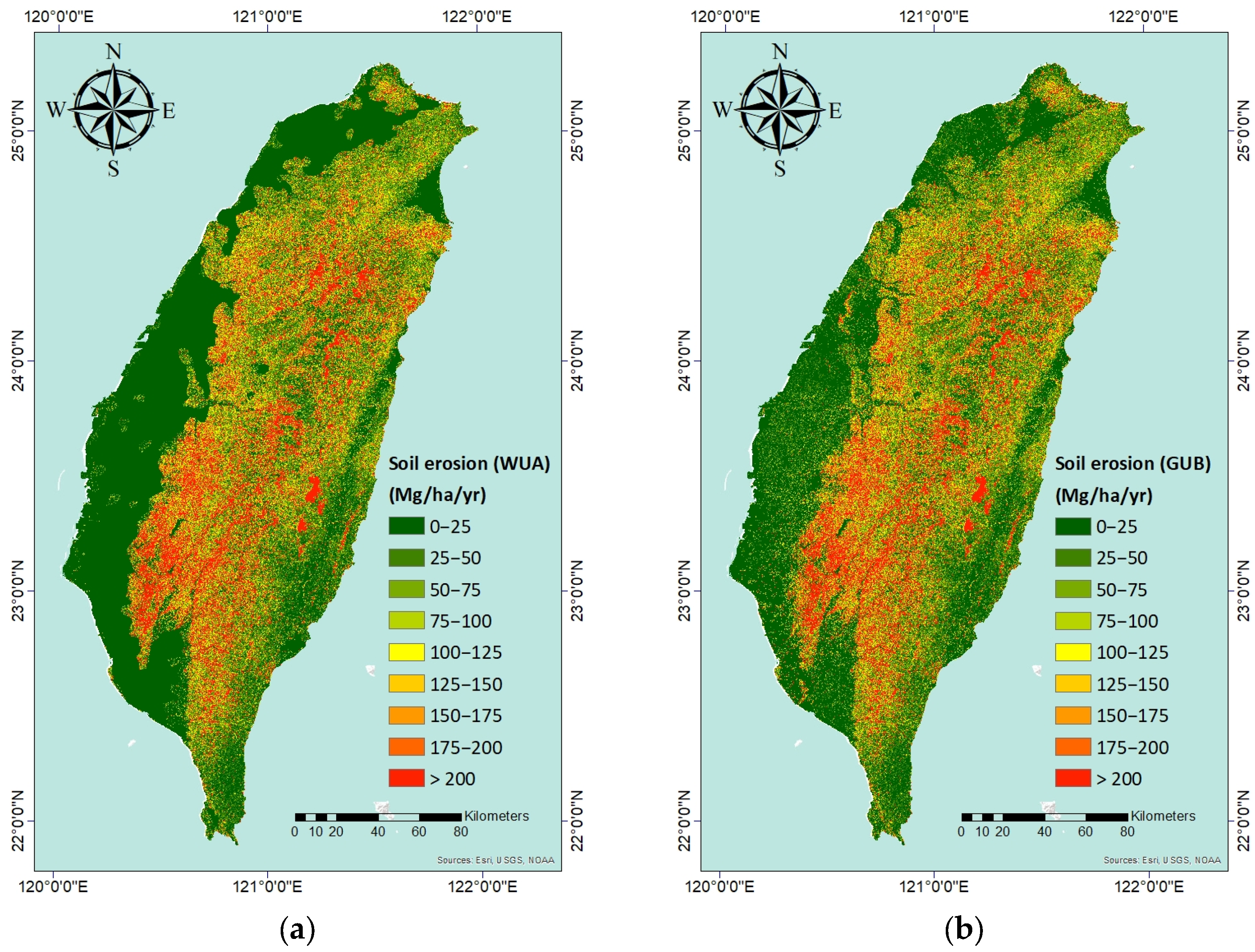
3.1. Assessment of Soil Erosion in Taiwan

The locations of rainfall stations and the corresponding Rm values were obtained from the SWCB. Since 2019, the SWCB has maintained a website (https://serv.swcb.gov.tw/) with the sole purpose of providing soil and water conservation practitioners with a query interface to obtain the Rm and Km values at any location in Taiwan (by interpolation) for use in the USLE to estimate soil erosion.
The distribution of Taiwan’s 323 rainfall (Rm) stations is depicted in Figure 3a. Their distribution nearly uniformly covers the entire island; therefore, using kriging to interpolate Rm should yield reliable estimates in areas without rainfall records. The results show that the Rm factor has a range of 6953 (MJ mm ha−1 hr−1 year−1) to 57,903 (MJ mm ha−1 hr−1 year−1), with 22,473 (MJ mm ha−1 hr−1 year−1) being the mean. It can be seen from Figure 3a that low Rm factors are distributed in the plains and foothills bordering the western and eastern coastal areas. In contrast, high Rm factors are dispersed in the mountains, with the southern mountains having the highest Rm factor compared to the rest of Taiwan. This distribution pattern results in frequent sediment-related disasters in southern Taiwan.
Figure 3b depicts the locations of 526 Km sampling points along with their corresponding Km values, which were also obtained from SWCB. The Km locations are typically found on the lower slopes or in the foothills of a mountain range. Consequently, the distribution of Km is not as uniform as the rainfall stations. As a result, using kriging to interpolate the distribution of Km does not result in a smooth distribution, as was the case with Rm. However, the number of Km points exceeded the number of rainfall stations by a ratio of 1.6 to 1. The Km factor ranges from 0.022 (Mg hr MJ−1 mm−1) to 0.061 (Mg hr MJ−1 mm−1), with a mean of 0.041 (Mg hr MJ−1 mm−1). The Km factors are lower at the northern and southern ends of Taiwan. The high Km values are concentrated in the central to south-central regions of Taiwan, which partially overlap with the regions with the highest Rm values.
The LS factor for Taiwan is shown in Figure 3c, and it was determined using SAGA GIS and the Desmet and Govers [38] equation, as described in the preceding section. This result was first published by Chen and Nguyen [41]. Eight categories were used to categorize Taiwan’s LS factors: 0.1, 0.1–0.5, 0.5–1, 1–2, 2–3, 3–5, 5–10, and >10. As can be observed, Taiwan’s mountain ranges are primarily purple in color, in contrast to the green of the plains, basins, and valleys.
Figure 3d shows the distribution of NDVI values derived from the 63 Sentinel-2 images, with positive values in green and negative values in red. Using Equation (9), the NDVI values were then converted to C factors and displayed in Figure 3e. Red indicates high C factors, which represent high soil erosion, and green indicates low C factors, which designate low soil erosion. The majority of Taiwan’s mountains are highly forested, as seen by their high NDVI values and low C factors. Numerous urban areas (with high C factors) can be found along the coast. However, due to the presence of the factor P (explained later), these urban areas were masked and left out of our analysis.
Finally, the P factors were evaluated using two separate datasets, ignoring soil conservation measures implemented at local scales. As shown in Figure 3f, we assigned P = 0 to urban areas for the World Urban Areas (WUA) dataset, while assigning P = 1 to non-urban areas. Similarly, we assumed P = 0 for areas inside urban boundaries while assuming P = 1 in all other regions for the Global Urban Boundaries (GUB) dataset, as shown in Figure 3g. Comparing the two figures reveals that the distribution of the two datasets in Taiwan is comparable. However, WUA tends to enclose more extensive areas than GUB at the same location.
Figure 4 depicts Taiwan’s soil erosion distribution determined by multiplying the Rm, Km, LS, C, and P factors together. Figure 4a,b illustrates the distribution of soil erosion for P factors based on the WUA and GUB datasets, respectively. Due to the assignment of P = 0, the soil erosion in urban areas is zero (green). Despite having low C factors, the majority of Taiwan’s mountains are colored red, which indicates substantial soil erosion. This is because the mountains’ high multiplicative value of Rm and LS factors was more than those that could be compensated by their low C factors. Taiwan’s plains, basins, and valleys are predominantly yellow to green, indicating less soil erosion (compared with the mountains). However, the WUA dataset (Figure 4a) produces a more uniform green color in these places, whereas the GUB dataset (Figure 4b) contains interspersed yellow regions.
Nevertheless, the average rates of soil erosion across the entire island of Taiwan are nearly identical for both datasets. They are 200.7 Mg ha−1 year−1 (WUA) and 207.4 Mg ha−1 year−1 (GUB), respectively. Since we did not take into account soil conservation measures implemented at local scales when determining P factors, these erosion rates represent the upper limit of soil erosion. Therefore, when we compared erosion pin measurements to our calculated erosion rates, we expected an overestimation, as shown in the following section.

3.2. Validation with Soil Erosion Pins

The RUSLE modeling results were validated by collecting and combining data from erosion pins located in Taiwan’s watersheds. Table 2 and Figure 5 provide measurements from two reservoir watersheds and three river watersheds. As seen in the second column of Table 2, the measurements of the erosion pins were initially arithmetically and then spatially averaged (as indicated in parentheses). It can be seen that both approaches yielded comparable results.
The measurement period is shown in the third column of Table 2. When the references provided the measurements as a yearly average, they were used directly. In cases where the measurements were not converted, the yearly average erosion depth was calculated by dividing the measurement by the number of days in the period and then multiplying the quotient by 365.
The equivalent soil erosion rate calculated from the data in column 2 is presented in the fourth column of Table 2, with the assumption that the unit weight of soil is γ = 1.4 Mg m−3 [16]. In addition, the fifth column of the table shows the predicted soil erosion rate as calculated by the RUSLE model. Finally, the table’s last column depicts the prediction ratio, which is the ratio between the predicted and measured soil erosion rates.
Despite the large scale of our modeling and the inherent uncertainties in the model parameters, our modeling achieves an acceptable level of agreement with the erosion pin measurements, as shown in Table 2. The table also indicates that soil erosion pin measurements fluctuate from year to year as a result of environmental events such as heavy precipitation and typhoons. The Shihmen reservoir watershed in northern Taiwan (Figure 5a) is a notable example, where the soil erosion rate was measured at 6.47 mm year−1 from September 2008 to October 2011, but increased to 9.80 mm year−1 in 2015 as a result of heavy plum rains and Typhoon Soudelor. This resulted in prediction ratios of 1.82 and 1.22 (based on the spatial averages) for the two periods, respectively. It is apparent that the RUSLE model employed in this study produced an overestimation of soil erosion rates by 82% and 22% during the two respective periods under examination. As previously discussed in Section 2.2, this result is consistent with expectations, as the model did not take into account the impact of local soil conservation measures, and the value for the parameter P factor was set to 1. When the two periods are combined, the prediction ratio becomes 1.54. It should be noted that the average soil erosion depths reported by Sinotech [49] and Lin [50] differ for the period from September 2008 to October 2011 for unknown reasons.
The second example of comparison is the Tsengwen reservoir in southern Taiwan (Figure 5a), which is known for having the highest average annual siltation amount in Taiwan. This assertion is supported by erosion pin measurements of the Tsengwen reservoir watershed, which yield an equivalent soil erosion rate of 318.9 Mg ha−1 year−1. The predicted erosion rate is found to be 331.5 Mg ha−1 year−1, resulting in an overestimation of only 4%. This model–observation agreement is superior to that of the Shihmen reservoir watershed and provides strong support for our methodology.
Finally, a comparison was conducted of the Tetzukou Creek, Taimali Creek, and Chinlun Creek watersheds located on the eastern coast of Taiwan, as illustrated in Figure 5a. Results from our model indicate that an overestimation of the soil erosion rate was observed in the Taimali Creek watershed and Chinlun Creek watershed, with prediction ratios of 1.20 and 1.36, respectively. However, contrary to expectations (and the other watersheds), the results of the model indicated an underestimation of the soil erosion rate for the Tetzukou Creek watershed, with a prediction ratio of 0.23. This discrepancy is attributed to the unique fact that, as depicted in Figure 5b, the Tetzukou Creek watershed is not entirely situated in mountainous regions (represented by dark green), but rather encompasses a majority of low-lying flat urban/rural and agricultural areas (represented by light green). Due to the fact that erosion pins were only installed in mountainous locations, the RUSLE-calculated average soil erosion rate for the entire watershed is much lower than that measured by erosion pins. Had the analysis been confined to the sub-watershed that was monitored by the erosion pins, the results would have been much closer.

3.3. Comparison of Soil Erosion by LS Class

In order to gain insight into the relationship between topography and soil erosion in Taiwan, our subsequent analysis divided the country into naturally occurring classes based on topography. As presented in Table 3, we used the eight LS classes to compare the various erosive factors in each class and the resulting soil erosion for each class. The results reveal well-defined trends for a variety of erosive factors, such as Rm, K, C, and P, as illustrated in Figure 6. It can be observed that Rm increases in a monotonic fashion with an increasing LS class. Conversely, Km and C factors demonstrate a decrease in a nearly monotonic manner with each LS class until the final LS class, where the trend reverses, albeit only slightly. Furthermore, a monotonic increase in both types of P factor is observed with an increasing LS class. It is noteworthy that the difference between the P factors of WUA and GUB is substantial in the lowest LS class, but this disparity diminishes and ultimately disappears as the LS class increases.
As demonstrated in Figure 6, the average soil erosion rates for both P factors (WUA and GUB) also rise with LS class in a nearly monotonic fashion. The increase follows an almost straight line until reaching the last LS class, at which point there is a significant upward jump. Interestingly, despite large differences in the P factor, the difference in soil erosion between WUA and GUB is almost nonexistent. This is why the average soil erosion rates of Taiwan presented in Section 3.1 were virtually identical for WUA and GUB (200.7 Mg ha−1 year−1 and 207.4 Mg ha−1 year−1).

4. Discussion

In this section, we begin by providing an overview of the study’s significance and key findings before delving into methodological specifics and validation processes. Subsequent paragraphs will comprehensively examine soil erosion in Taiwan, with an emphasis on the unique research approach and validation of the modeling results.

4.1. Methodological Rigor and Validation

This study represents Taiwan’s first comprehensive examination of soil erosion, extending beyond individual watersheds and agricultural areas to encompass the entire island. Instead of relying on outdated data or empirical formulas to estimate the Rm and Km values, the most recent data from the government were used. The LS factor was determined using the same methodology that the European Soil Data Centre used. A locally derived equation between NDVI and the C factor was used to calculate the C factors. The P factors were derived from two separate public datasets to compare the resulting soil erosion rate. The results were found to be nearly identical (200.7 Mg ha−1 year−1 and 207.4 Mg ha−1 year−1). Lin and Huang [25] estimated soil erosion in agricultural areas to be 4243.70 ton/ha in 1995 and 4605.98 ton/ha (in their original unit) in 2006. The figures are excessively high and may have been misreported.
While the presence of intensive agriculture in Taiwan’s plains, along with the heterogeneity in soil types and compositions, does introduce complexity into the dynamics of soil erosion, our modeling analysis emphasizes that the island’s unique environmental characteristics and topographical patterns exert an even more significant influence on these dynamics. Taiwan’s diverse topography, encompassing rugged mountainous terrain and low-lying valleys, gives rise to varying levels of erosion susceptibility across different geographical regions. The effects of urbanization and rapid land use transformations are particularly pronounced on this island, significantly impacting soil erosion processes. In contrast, deforestation plays a relatively less prominent role within this context.
To validate the modeling results, soil erosion pin measurements were compared with the modeling results in two reservoir watersheds and three river watersheds. The results indicate that the RUSLE model overestimated soil erosion in four of the five watersheds examined, with a prediction ratio ranging from 1.04 to 1.82. This is consistent with expectations, as the model did not take into account local soil conservation measures, which was necessitated by the absence of comprehensive island-wide data. However, the model underestimated the soil erosion of a river watershed, with a prediction ratio of 0.23. This discrepancy can be attributed to the unique topography of the watershed, which featured more than half of its area on flat ground. As a result, the average soil erosion rate for the entire watershed calculated by RUSLE was much lower than the erosion pins, which were installed only in the mountainous portion of the watershed. In general, the validation suggests that the model produces reasonable estimates of soil erosion in Taiwan.
Moreover, it is worth noting that the average soil erosion rate calculated using the RUSLE model in Taiwan may seem relatively high when compared with erosion rates in European Union (EU) countries. As per findings reported by Panagos et al. [53], the mean soil erosion rate within the EU is reported at 2.46 Mg ha−1 year−1. In contrast, our study suggests that the mean soil erosion rate in Taiwan falls within the range of 200.7–207.4 Mg ha−1 year−1. However, it is worth noting that other studies have reported high soil erosion rates in different regions of the world. For example, Hart et al. [54] used erosion pins to measure soil erosion in the middle of Tennessee, USA. They found an average erosion rate of 26 mm year−1, equivalent to 364 Mg ha−1 year−1 (assuming γ = 1.4 Mg m−3), for the divides between the gullies and an average erosion rate of 14 mm year−1, roughly equivalent to 196 Mg ha−1 year−1, for the gullies. Similarly, Simplício et al. [55] measured soil erosion in the Gilbués desertification region of Brazil, and found an average soil erosion rate of 7.5 mm year−1 or 100 Mg ha−1 year−1. Furthermore, Aburto et al. [56] used erosion pins to measure soil loss in pine plantations in the coastal range of Chile and found soil erosion rates in micro-catchments ranging from 21.4 to 88.9 Mg ha−1 year−1. These soil erosion pin measurements in different parts of the world demonstrate that high soil erosion rates are a global issue.
Finally, we acknowledge that our modeling results have shown an increase in the predicted rate of soil erosion within the Shihmen reservoir watershed compared to previous studies conducted in the same area [15,16]. This increase can be attributed to the use of the newly available Rm and Km data from the SWCB. A comparison between the mean Rm values from the SWCB and those from Lu et al. [35] reveals a 1.45-fold increase, while a comparison of the mean Km values from the SWCB and those from Wann and Hwang [36] indicates a 1.25-fold increase. Consequently, the incorporation of these updated Rm and Km values in our study led to an overall soil erosion increase by a factor of 1.81. This explains the observed rise in the predicted soil erosion rate within the Shihmen reservoir watershed. Furthermore, in terms of validation through erosion pin measurements, as presented in Section 3.2, our modeling results were notably higher than the measurements obtained by erosion pins from September 2008 to October 2011 within the Shihmen Reservoir watershed, with a prediction ratio of 1.82. However, in a subsequent year (2015) within the same watershed, soil erosion pin measurements exhibited a much closer agreement with our modeling results, showing a prediction ratio of 1.22. Importantly, the disparity between the predicted and measured soil erosion rates in the Tsengwen reservoir watershed was minimal, with a prediction ratio of 1.04.

4.2. Limitations of this Study and Future Directions

This study represents a comprehensive island-wide investigation, primarily aimed at providing a thorough assessment of soil erosion throughout Taiwan. To achieve this ambitious goal, we used the RUSLE model and the most current available data. While we have improved our methodology by updating the Rm factor and Km factor with the latest data, adopting the same methodology as the European Soil Data Centre for computing the LS factor, using 63 Sentinel-2 images for C factor calculation, and dividing the island into urban and non-urban zones to derive the P factor, some limitations remain in our approach.
The most significant limitation is the deliberate exclusion of local soil conservation measures from our study due to the absence of comprehensive and detailed island-wide data. Given the vast expanse of our study area, which covers approximately 36,197 square kilometers, collecting data on soil conservation practices such as terracing, contour farming, cover cropping, mulching, riparian buffers, grass waterways, sediment basins, and ponds was impractical. These strategies and practices are employed to prevent or reduce soil erosion. It is important to note that our estimation of soil erosion is likely an upper-bound approximation due to the omission of these local soil conservation strategies. This limitation arises from the challenge of gathering site-specific data across the entire territory and conducting subsequent analyses. Nevertheless, it is crucial to emphasize that our results provide confidence in the robustness of our methodology. Our study serves as a foundational cornerstone for future research in Taiwan, aimed at refining estimations to reduce overestimations and enabling cross-national comparative analyses.
A second potential avenue for improvement in future research relates to the collection of additional erosion pin measurement data. Such data would support a more in-depth investigation into the factors contributing to variations in model performance across different geographical regions. Specifically, it would allow us to determine whether disparities are attributable to local soil conservation measures or other underlying factors.

5. Conclusions

In conclusion, this study presents a systematic approach to modeling soil erosion in Taiwan that overcomes the limitations of previous research focused on individual watersheds. Using more recent and precise data from both field surveys and remote sensing, this approach improves the accuracy of soil erosion modeling. However, the high Rm values observed in Taiwan highlight the urgent need for research on the effects of climate change on soil erosion. This new endeavor will require greater collaboration among experts in various related fields in order to advance our understanding of the complex relationships between climatic and pedological factors.

Author Contributions

Conceptualization, W.C.; Data Curation, W.C. and K.A.N.; Funding Acquisition, W.C.; Investigation, W.C., K.A.N. and Y.-C.H.; Methodology, W.C. and K.A.N.; Project Administration, W.C.; Resources, W.C.; Software, K.A.N.; Supervision, W.C.; Validation, W.C. and Y.-C.H.; Visualization, W.C. and K.A.N.; Writing—Original Draft, W.C. and K.A.N.; Writing—Review & Editing, W.C., K.A.N. and Y.-C.H. All authors have read and agreed to the published version of the manuscript.

Funding

This study was partially supported by the Ministry of Science and Technology (Taiwan) Research Projects (Grant Numbers MOST 110-2121-M-027-001 and MOST 111-2121-M-027-001).

Data Availability Statement

The data used in this study are not publicly available due to restrictions imposed by the data owner or source. Therefore, the data cannot be disseminated or shared as part of this publication. Interested researchers can request access to the data directly from the data owner or source, subject to their terms and conditions. The authors confirm that they do not have the right to distribute the data used in this study.

Acknowledgments

We thank Zheping Shen for collecting the Rm and Km data during the initial stages of this study’s analysis. We wish to express our appreciation to the editors and anonymous reviewers, whose valuable comments have greatly improved the quality of this paper.

Conflicts of Interest

The authors declare no conflict of interest.

References

  1. Hudson, N. Soil Conservation; B T Batsford Limited: London, UK, 1981; 324p. [Google Scholar]
  2. Wischmeier, W.H.; Smith, D.D. Predicting Rainfall-Erosion Losses from Cropland East of the Rocky Mountains: Guide for Selection of Practices for Soil and Water Conservation (No. 282); Agricultural Research Service, US Department of Agriculture: Washington, DC, USA, 1965.
  3. Wischmeier, W.H.; Smith, D.D. Predicting Rainfall Erosion Losses: A Guide to Conservation Planning (No. 537); Department of Agriculture, Science and Education Administration: Washington, DC, USA, 1978.
  4. Renard, K.G.; Foster, G.R.; Weesies, G.A.; McCool, D.K.; Yoder, D.C. Predicting Soil Erosion by Water: A Guide to Conservation Planning with the Revised Universal Soil Loss Equation (RUSLE), Agricultural Handbook Number 703; United States Department of Agriculture: Washington, DC, USA, 1997.
  5. Borrelli, P.; Alewell, C.; Alvarez, P.; Anache, J.A.A.; Baartman, J.; Ballabio, C.; Bezak, N.; Biddoccu, M.; Cerdà, A.; Chalise, D.; et al. Soil erosion modelling: A global review and statistical analysis. Sci. Total Environ. 2021, 780, 146494. [Google Scholar] [CrossRef] [PubMed]
  6. Lo, K.F.A. Quantifying soil erosion for the Shihmen reservoir watershed, Taiwan. Agric. Syst. 1994, 45, 105–116. [Google Scholar] [CrossRef]
  7. Chen, C.N.; Tsai, C.H.; Tsai, C.T. Simulation of runoff and suspended sediment transport rate in a basin with multiple watersheds. Water Resour. Manag. 2011, 25, 793–816. [Google Scholar] [CrossRef]
  8. Chiu, Y.J.; Chang, K.T.; Chen, Y.C.; Chao, J.H.; Lee, H.Y. Estimation of soil erosion rates in a subtropical mountain watershed using 137Cs radionuclide. Nat. Hazards 2011, 59, 271–284. [Google Scholar] [CrossRef]
  9. Chen, S.K.; Liu, C.W.; Chen, Y.R. Assessing soil erosion in a terraced paddy field using experimental measurements and universal soil loss equation. Catena 2012, 95, 131–141. [Google Scholar] [CrossRef]
  10. Wu, C.-H.; Chen, C.-N.; Tsai, C.-H.; Tsai, C.-T. Estimating sediment deposition volume in a reservoir using the physiographic soil erosion-deposition model. Int. J. Sediment Res. 2012, 27, 362–377. [Google Scholar] [CrossRef]
  11. Chen, S.K.; Chen, Y.R.; Peng, Y.H. Experimental study on soil erosion characteristics in flooded terraced paddy fields. Paddy Water Environ. 2013, 11, 433–444. [Google Scholar] [CrossRef]
  12. Lin, C.P.; Chen, C.N.; Wang, Y.M.; Tsai, C.H.; Tsai, C.T. Spatial distribution of soil erosion and suspended sediment transport rate for Chou-Shui river basin. J. Earth Syst. Sci. 2014, 123, 1517–1539. [Google Scholar] [CrossRef]
  13. Jien, S.H.; Lee, M.H.; Hseu, Z.Y.; Wang, H.H. Erosion potential estimation by network measurement of soil properties in coastal areas after clearcutting. Int. J. Distrib. Sens. Netw. 2015, 11, 281321. [Google Scholar] [CrossRef]
  14. Lin, B.S.; Thomas, K.; Chen, C.K.; Ho, H.C. Evaluation of soil erosion risk for watershed management in Shenmu watershed, central Taiwan using USLE model parameters. Paddy Water Environ. 2016, 14, 19–43. [Google Scholar] [CrossRef]
  15. Chen, W.; Li, D.H.; Yang, K.J.; Tsai, F.; Seeboonruang, U. Identifying and comparing relatively high soil erosion sites with four DEMs. Ecol. Eng. 2018, 120, 449–463. [Google Scholar] [CrossRef]
  16. Liu, Y.H.; Li, D.H.; Chen, W.; Lin, B.S.; Seeboonruang, U.; Tsai, F. Soil erosion modeling and comparison using slope units and grid cells in Shihmen reservoir watershed in Northern Taiwan. Water 2018, 10, 1387. [Google Scholar] [CrossRef]
  17. Nguyen, K.A.; Chen, W.; Lin, B.S.; Seeboonruang, U.; Thomas, K. Predicting sheet and rill erosion of Shihmen reservoir watershed in Taiwan using machine learning. Sustainability 2019, 11, 3615. [Google Scholar] [CrossRef]
  18. Lu, C.M.; Chiang, L.C. Assessment of sediment transport functions with the modified SWAT-Twn model for a Taiwanese small mountainous watershed. Water 2019, 11, 1749. [Google Scholar] [CrossRef]
  19. Chen, C.N.; Tfwala, S.S.; Tsai, C.H. Climate change impacts on soil erosion and sediment yield in a watershed. Water 2020, 12, 2247. [Google Scholar] [CrossRef]
  20. Tsai, F.; Lai, J.S.; Nguyen, K.A.; Chen, W. Determining Cover Management Factor with Remote Sensing and Spatial Analysis for Improving Long-Term Soil Loss Estimation in Watersheds. ISPRS Int. J. Geo-Inf. 2021, 10, 19. [Google Scholar] [CrossRef]
  21. Nguyen, K.A.; Chen, W.; Lin, B.S.; Seeboonruang, U. Comparison of ensemble machine learning methods for soil erosion pin measurements. ISPRS Int. J. Geo-Inf. 2021, 10, 42. [Google Scholar] [CrossRef]
  22. Nguyen, K.A.; Chen, W. DEM-and GIS-Based Analysis of Soil Erosion Depth Using Machine Learning. ISPRS Int. J. Geo-Inf. 2021, 10, 452. [Google Scholar] [CrossRef]
  23. Chiang, L.C.; Liao, C.J.; Lu, C.M.; Wang, Y.C. Applicability of modified SWAT model (SWAT-Twn) on simulation of watershed sediment yields under different land use/cover scenarios in Taiwan. Environ. Monit. Assess. 2021, 193, 250. [Google Scholar] [CrossRef]
  24. Chen, W.; Wang, W.H.; Nguyen, K.A. Soil Erosion and Deposition in a Taiwanese Watershed Using USPED. Sustainability 2022, 14, 3397. [Google Scholar] [CrossRef]
  25. Lin, Y.C.; Huang, S.L. Spatial Emergy Synthesis of the Environmental Impacts from Agricultural Production System Change–A Case Study of Taiwan. In Proceedings of the 7th Biennial Emergy Research Conference, Gainesville, FL, USA, 12–14 January 2012. [Google Scholar]
  26. Brady, N.C.; Weil, R.R.; Weil, R.R. The Nature and Properties of Soils, 15th ed.; Pearson Education Limited: Harlow, UK, 2017. [Google Scholar]
  27. Lee, M.; Charman, J. Soil Erosion. Geomorphol. Eng. 2005, 1, 287. [Google Scholar]
  28. Huh, C.A.; Su, C.C. Distribution of fallout radionuclides (7Be, 137Cs, 210Pb and 239,240 Pu) in soils of Taiwan. J. Environ. Radioact. 2004, 77, 87–100. [Google Scholar] [CrossRef] [PubMed]
  29. Copper, J.C. Taiwan. 2022. Available online: https://www.britannica.com/place/Taiwan (accessed on 20 June 2022).
  30. Water Resources Agency, MOEA. 2023. Precipitation in Taiwan. Available online: https://eng.wra.gov.tw/cp.aspx?n=5121 (accessed on 13 September 2023).
  31. Huang, S.C.; Huang, W.R.; Wu, Y.C.; Yu, Y.C.; Chu, J.L.; Jou, B.J.D. Characteristics and causes of Taiwan’s extreme rainfall in 2022 January and February. Weather. Clim. Extrem. 2022, 38, 100532. [Google Scholar] [CrossRef]
  32. Lien, T.Y.; Yeh, T.K.; Hong, J.S.; Hsiao, T.Y. Variations in GPS precipitable water vapor and rainfall during the 2006–2019 Mei-yu season in Taiwan. Adv. Space Res. 2022, 70, 1375–1387. [Google Scholar] [CrossRef]
  33. Hseu, Z.-Y.; Tsai, C.-C.; Chen, Z.-S. Soil, Science under the Soles of the Feet; Wu-Nan Publishing: Wuhan, Chian, 2017; 206p. (In Chinese) [Google Scholar]
  34. Hseu, Z.-Y. Taiwan Soil Classification. Available online: http://teacher.ac.ntu.edu.tw/zh_tw/Zhengyi/SoilSurveyClassification/Taiwansoilclassification (accessed on 18 September 2023). (In Chinese).
  35. Lu, J.-Y.; Su, C.-C.; Wu, I.-Y. Revision of the isoerodent map for the Taiwan area. J. Chin. Soil Water Conserv. 2005, 36, 159–172. (In Chinese) [Google Scholar]
  36. Wann, S.-S.; Hwang, J.-I. Soil erosion on hillslopes of Taiwan. J. Chin. Soil Water Conserv. 1989, 20, 17–45. (In Chinese) [Google Scholar]
  37. Foster, G.R.; Wischmeier, W. Evaluating irregular slopes for soil loss prediction. Trans. ASAE 1974, 17, 305–309. [Google Scholar] [CrossRef]
  38. Desmet, P.J.J.; Govers, G. A GIS procedure for automatically calculating the USLE LS factor on topographically complex landscape units. J. Soil Water Conserv. 1996, 51, 427–433. [Google Scholar]
  39. Conrad, O.; Bechtel, B.; Bock, M.; Dietrich, H.; Fischer, E.; Gerlitz, L.; Wehberg, J.; Wichmann, V.; Boehner, J. System for Automated Geoscientific Analyses (SAGA) v. 2.1.4. Geosci. Model. Dev. 2015, 8, 1991–2007. [Google Scholar] [CrossRef]
  40. Panagos, P.; Borrelli, P.; Meusburger, K. A new European slope length and steepness factor (LS-factor) for modeling soil erosion by water. Geosciences 2015, 5, 117–126. [Google Scholar] [CrossRef]
  41. Chen, W.; Nguyen, K.A. The New Island-Wide LS Factors of Taiwan, with Comparison with EU Nations. Sustainability 2022, 14, 3059. [Google Scholar] [CrossRef]
  42. The European Space Agency. MultiSpectral Instrument (MSI) Overview, Sentinel Online. Available online: https://sentinel.esa.int/web/sentinel/technical-guides/sentinel-2-msi/msi-instrument (accessed on 22 June 2022).
  43. Gorelick, N.; Hancher, M.; Dixon, M.; Ilyushchenko, S.; Thau, D.; Moore, R. Google Earth Engine: Planetary-scale geospatial analysis for everyone. Remote Sens. Environ. 2017, 202, 18–27. [Google Scholar] [CrossRef]
  44. The European Space Agency. Overview, Sentinel Online. Available online: https://sentinel.esa.int/web/sentinel/missions/sentinel-2/overview (accessed on 22 June 2022).
  45. Lin, W.T.; Lin, C.Y.; Chou, W.C. Assessment of vegetation recovery and soil erosion at landslides caused by a catastrophic earthquake: A case study in Central Taiwan. Ecol. Eng. 2006, 28, 79–89. [Google Scholar] [CrossRef]
  46. Lin, W.T.; Chou, W.C.; Lin, C.Y. Earthquake-induced landslide hazard and vegetation recovery assessment using remotely sensed data and a neural network-based classifier: A case study in central Taiwan. Nat. Hazards 2008, 47, 331–347. [Google Scholar] [CrossRef]
  47. Chou, W.C.; Lin, W.T.; Lin, C.Y. Vegetation recovery patterns assessment at landslides caused by catastrophic earthquake: A case study in central Taiwan. Environ. Monit. Assess. 2009, 152, 245–257. [Google Scholar] [CrossRef]
  48. Li, X.; Gong, P.; Zhou, Y.; Wang, J.; Bai, Y.; Chen, B.; Hu, T.; Xiao, Y.; Xu, B.; Yang, J.; et al. Mapping global urban boundaries from the global artificial impervious area (GAIA) data. Environ. Res. Lett. 2020, 15, 094044. [Google Scholar] [CrossRef]
  49. Lin, W.-C. A Study on Soil Erosion and Influential Hydrologic and Geographic Factors for Shihmen Reservoir Watershed. Master’s Thesis, Tamkang University, New Taipei City, Taiwan, 2014. (In Chinese). [Google Scholar]
  50. Sinotech Engineering Consultants Inc. Evaluation on Remediation Effectiveness of Conservation and Management for Shihmen Reservoir Watershed in 2015, Soil and Water Conservation Bureau (SWCB) Research Report; Council of Agriculture, Executive Yuan, Taiwan ROC: Taipei, Taiwan, 2015. (In Chinese)
  51. Lee, C.-Y.; Fu, K.-L.; Tsai, M.-F.; Chien, Y.-D.; Hsu, C.-K.; Lin, B.-S. Application of Erosion Pins Measurement Data to Evaluate Soil Erosion Suppression Rate in Tsengwen Reservoir Watershed. Sinotech Eng. 2015, 129, 9–18. (In Chinese) [Google Scholar]
  52. Sinotech Engineering Consultants Inc. Multi-Scale Monitoring Investigation and Change Analysis of Large-Scale Sediment Areas, Midterm Report, Soil and Water Conservation Bureau (SWCB) Research Report; Council of Agriculture, Executive Yuan, Taiwan ROC: Taipei, Taiwan, 2017. (In Chinese)
  53. Panagos, P.; Borrelli, P.; Poesen, J.; Ballabio, C.; Lugato, E.; Meusburger, K.; Montanarella, L.; Alewell, C. The new assessment of soil loss by water erosion in Europe. Environ. Sci. Policy 2015, 54, 438–447. [Google Scholar] [CrossRef]
  54. Hart, E.A.; Mills, H.H.; Li, P. Measuring erosion rates on exposed limestone residuum using erosion pins: A 10-year record. Phys. Geogr. 2017, 38, 541–555. [Google Scholar] [CrossRef]
  55. Simplício, A.A.; Costa, C.A.; Navarro-Hevia, J.; de Araújo, J.C. Erosion at hillslope and micro-basin scales in the Gilbués desertification region, Northeastern Brazil. Land Degrad. Dev. 2021, 32, 1487–1499. [Google Scholar] [CrossRef]
  56. Aburto, F.; Cartes, E.; Mardones, O.; Rubilar, R. Hillslope soil erosion and mobility in pine plantations and native deciduous forest in the coastal range of south-central Chile. Land Degrad. Dev. 2021, 32, 453–466. [Google Scholar] [CrossRef]
Figure 1. The study area: (a) Location of the island of Taiwan on the globe, and (b) Enlargement of Taiwan, showing its elevation.
Agriculture 13 01945 g001
Figure 2. The flowchart of this study.
Agriculture 13 01945 g002
Figure 3. The spatial distributions of (a) Rm factor, (b) Km factor, (c) LS factor, (d) NDVI, (e) C factor, and P factor, based on (f) World Urban Areas and (g) Global Urban Boundaries.
Agriculture 13 01945 g003aAgriculture 13 01945 g003bAgriculture 13 01945 g003c
Figure 4. The soil erosion in Taiwan (a) based on World Urban Areas (WUA), and (b) based on Global Urban Boundaries (GUB).
Agriculture 13 01945 g004
Figure 5. In panel (a), the map delineates the geographical positions of the five watersheds where measurements of soil erosion pins were obtained, serving as the validation dataset for the findings of this study. Panel (b) provides an enlarged view of one of these five watersheds, specifically the Tetzukou Creek watershed, which is located in the northeastern region of Taiwan.
Agriculture 13 01945 g005
Figure 6. The average erosive factors relative to LS classes.
Agriculture 13 01945 g006
Table 1. The dates and number of images of SENTINEL-2 that were used in this study.
Year2018201920202021
Number of visits in the year2727566
Number of visits selected (cloud < 1%)0789
Dates of the visits used (number of images) 20190131 (1)20200121 (2)20210115 (9)
20190312 (3)20200131 (1)20210130 (4)
20191028 (2)20200210 (2)20210204 (2)
20191112 (3)20200225 (2)20210316 (5)
20191117 (3)20200301 (3)20210405 (1)
20191212 (2)20200813 (1)20210709 (3)
20191222 (2)20201002 (2)20210828 (1)
20201111 (2)20211002 (1)
20211111 (6)
Table 2. Validation of calculated soil erosion rates using soil erosion pin measurements.
WatershedAverage Erosion Depth Measured by Erosion Pins (mm Year−1)Period of MeasurementEquivalent Erosion Rate
(Mg ha−1 Year−1)
RUSLE (GUB)
(Mg ha−1 Year−1)
Prediction Ratio
(Predicted/Measured)
Shihmen reservoir [49]6.47
(6.65)
September 2008 to October 201190.6 (93.1)169.9 1.88(1.82)
Shihmen reservoir [50]9.80
(9.93)
April 2015 to August 2015137.2 (139.0) 169.91.24 (1.22)
Shihmen reservoir [50]7.72
(7.86)
September 2008 to October 2011 and April 2015 to August 2015108.1
(110.0)
169.91.57 (1.54)
Tsengwen reservoir [51]23.10
(22.78)
May 2011 to September 2013 (883 days) 323.4 (318.9)331.51.03 (1.04)
Tetzukou creek [52]15.53
(15.80)
3 May 2017 to 7 July 2017 (67 days)217.4 (221.2)51.9 0.24 (0.23)
Taimali creek [52]23.02
(24.21)
3 May 2017 to 7 July 2017 (67 days)322.3 (338.9)405.5 1.26 (1.20)
Chinlun creek [52]20.70
(21.82)
3 May 2017 to 7 July 2017 (67 days)289.8 (305.5)414.8 1.43 (1.36)
Table 3. The average erosive factors of various LS classes.
LS ClassRmKmCWorld Urban AreasGlobal Urban Boundaries
PSoil Erosion (Mg ha−1 Year−1)PSoil Erosion (Mg ha−1 Year−1)
<0.118,056.90.04340.2000.2711.10.7453.8
0.1–0.518,713.30.04220.1860.37314.20.75230.5
0.5–119,907.30.04160.1340.57136.80.84556.0
1–221,453.40.04100.0900.72167.00.92491.0
2–322,506.50.04060.0580.82091.30.963113.3
3–523,443.10.04010.0350.897109.90.985112.7
5–1024,432.60.03980.0200.966145.60.997150.0
>1024,455.70.04000.0240.996479.61.000480.7
Disclaimer/Publisher’s Note: The statements, opinions and data contained in all publications are solely those of the individual author(s) and contributor(s) and not of MDPI and/or the editor(s). MDPI and/or the editor(s) disclaim responsibility for any injury to people or property resulting from any ideas, methods, instructions or products referred to in the content.

