Article

Distributed Task Allocation and Path Planning Strategies for Cooperative UAV Swarms


by
Jiaxiang Xu
1,2,
Xinru Li
1,
Yunsheng Xu
2,
Feng Zhou
1,
Xingchen Xiang
2,
Chen Li
2 and
Tianping Deng
1,*
1
Hubei Key Laboratory of Internet of Intelligence, School of Electronic Information and Communications, Huazhong University of Science and Technology, Wuhan 430074, China
2
Three Gorges Hi-Tech Information Technology Co., Ltd., Yichang 443000, China
*
Author to whom correspondence should be addressed.
Appl. Sci. 2026, 16(9), 4428; https://doi.org/10.3390/app16094428
Submission received: 27 March 2026 / Revised: 28 April 2026 / Accepted: 29 April 2026 / Published: 1 May 2026

Abstract

The rapid advancement of unmanned aerial vehicle (UAV) technology has led to its widespread adoption in military reconnaissance, disaster monitoring, environmental inspection, and related fields. However, a single UAV often faces limitations when executing large-scale and complex missions. UAV swarm technology, which employs multi-agent collaboration, can significantly improve task execution efficiency and overall system performance, representing an area of considerable research importance. Current studies on task allocation and path planning for UAV swarms exhibit certain shortcomings, particularly the high computational complexity and insufficient real-time performance of existing path planning methods when applied to highly dynamic, multi-objective, and large-scale complex scenarios. To address the above challenge, this paper proposes a Gale-Shapley-based Genetic Algorithm (GSGA) for UAV swarm task allocation and path planning. First, a multi-UAV data inspection system model is formulated based on an energy consumption model, analyzing the influence of factors including geographical fairness, data utility, and energy consumption. The proposed GSGA integrates the Gale-Shapley stable matching algorithm for one-to-one task assignment between UAVs and sub-regions with a genetic algorithm optimized for intra-region path planning. Dynamic programming is further employed to refine the flight paths. The results show that the GSGA strategy can effectively improve the balance of task allocation, optimize path length and inspection quality. The proposed method demonstrated robust performance in complex scenarios characterized by numerous task targets and intricate regional partitions, consistently enabling UAVs to complete inspection tasks with high collaborative efficiency.

1. Introduction

The advancement of information technology has propelled unmanned aerial vehicles (UAVs) to become indispensable tools across a broad spectrum of fields, from military operations to diverse civilian applications [1,2]. By carrying cameras, sensors, and other equipment, UAVs can perform various tasks such as aerial photography, reconnaissance, monitoring, search and rescue, and cargo delivery. From early military reconnaissance and border patrol to modern package delivery and agricultural pest control, UAVs are widely adopted and continually expanding their application boundaries due to their unique aerial maneuverability advantages, agile mobility, and remote operation capabilities [3,4,5]. In instances where single-UAV systems were employed, their functionality and efficiency were fully recognized. However, as mission complexity continues to increase and mission scenarios expand in scale, the limitations of single-UAV systems have gradually become apparent. From payload capacity and endurance to perception and response capabilities in complex environments, single-UAV systems struggle to meet the demands of large-scale, diverse missions. In this context, UAV swarm technology has emerged. This technology integrates multiple UAVs into a cohesive system capable of coordinated operations and mutual support, endowing the swarm with capabilities surpassing those of any single unit [5]. Compared with single-UAV operations, swarm systems enable task decomposition and reconfiguration through multi-aircraft coordination. This approach enhances payload capacity while extending endurance through task relay. Equipped with comprehensive sensing technologies, swarms can adapt more effectively to complex environments, while distributed control architectures support the timely execution of dynamic tasks [6]. By adopting swarm operations, these systems overcome the operational limitations of single UAV. The novel mission capabilities generated by swarm integration have become essential tools for time-critical, complex, and large-scale tasks [7].
With developments in communication and artificial intelligence, UAVs can perform collaborative operations. Task allocation serves as a core component of UAV swarm systems, critically influencing the operational efficiency of the swarm, the overall utilization of system resources, and the effectiveness of mission execution [5]. The two most common task allocation methods for UAVs are centralized and distributed task allocation. Centralized task allocation relies on a central controller to collectively plan and assign tasks, typically employing integer programming, graph theory, or auction-based mechanisms [8,9,10]. This approach is more suitable for smaller-scale systems and often achieves globally optimal solutions. However, it suffers from high computational complexity and heavy dependency on the central controller. Distributed task allocation enables each UAV to make independent decisions based on local information, following specific mechanisms and logic, with task coordination achieved through communication. This method is more suitable for large-scale systems and dynamic environments, offering greater robustness in UAV architecture design. Nonetheless, it typically struggles to achieve global optimization and requires well-designed communication protocols, consistency, and algorithmic stability.
Compared to single-UAV path planning, swarm path planning involves more complex constraints [5]. In contrast to foundational issues such as single-UAV conflict resolution, path optimality, and real-time path maintenance, it must address multi-UAV conflicts, collaboration, communication limitations, and environmental dynamics. Objectives extend beyond path feasibility and optimality to ensure coordinated and efficient task execution through multi-UAV collaboration within the swarm environment. The primary planning objectives include minimizing total cluster flight time, avoiding inter-cluster conflicts, maintaining stable communication links, reducing energy consumption, and satisfying payload and range constraints. To address these, various path planning methods have been developed, each with distinct characteristics. In multi-objective and multi-task scenarios, swarm intelligence algorithms like ant colony optimization, genetic algorithm (GA), and particle swarm optimization are widely employed for their strong adaptability [11,12,13]. More recently, reinforcement learning (RL) has emerged as a prominent research focus due to its notable adaptive and learning capabilities for path planning [14], as well as its ability to balance energy consumption and system utility [15]. Additionally, distributed and cooperative path planning strategies that enable real-time communication among UAVs while leveraging the strengths of multiple algorithms have also become a focal point in path planning research. The integration of these diverse methodologies remains the primary trend in path planning.
Current research exhibits a trend toward hybrid hierarchical strategies that capitalize on complementary advantages, often by integrating centralized and distributed mechanisms or by combining multiple algorithms [5], such as evolutionary computation with rule-based methods or learning modules. Nevertheless, several critical challenges remain unaddressed. These include the need to effectively balance energy consumption, geographic fairness, and data efficiency in task allocation, as well as the development of intra-regional path planning solutions that are both computationally tractable and scalable. Furthermore, ensuring a stable equilibrium in resource allocation between UAVs and task subregions under heterogeneous conditions poses a significant challenge [7], along with the difficulty of maintaining reasonable computational complexity and real-time performance as the number of UAVs and targets increases [16].
Therefore, this paper focuses on task allocation and path planning for UAV swarms in complex inspection scenarios and proposes a two-stage GSGA strategy combining a genetic algorithm with Gale-Shapley stable matching. The first stage uses a genetic algorithm to optimize subregion flight paths, maximizing the weighted sum of data collection and geographic fairness under energy constraints. The second stage employs Gale-Shapley matching based on bilateral utility preferences to achieve one-to-one stable allocation between UAVs and subregions, effectively decoupling path planning from task allocation. Although deep reinforcement learning (DRL) has shown promising performance in related joint optimization tasks [15,17], its direct application to UAV swarm inspection is limited by high computational overhead and poor interpretability, which motivates our pursuit of a more lightweight and transparent approach. Unlike existing GA-based or simple pairing methods, GSGA avoids hybrid coding or basic Greedy matching, ensuring global load balancing and allocation stability [11]. This method jointly considers energy consumption, data utility, and geographic fairness while enhancing intra-region path planning scalability through dynamic programming and GA, eliminating resource allocation instability under heterogeneous conditions, and controlling computational complexity via decoupling to maintain real-time performance. Compared with joint optimization that couples discrete allocation and continuous planning into an NP-hard problem, two-stage decoupling reduces subproblem sizes, allows efficient solving with specialized algorithms, and supports parallelization [13]. The Gale-Shapley algorithm naturally guarantees matching stability, avoiding local optima or frequent reallocation. Thus, the proposed strategy is well-suited for large-scale dynamic inspection scenarios.
The main contributions of this paper are summarized as follows:
1.
A comprehensive system model is developed that jointly considers energy consumption, inspection data utility, and geographical fairness, enabling balanced task allocation and path planning in large-scale UAV swarm inspection scenarios;
2.
GA is employed to optimize UAV flight paths within subregions, maximizing a weighted objective of data collection efficiency and geographic coverage, with dynamic programming introduced for computationally efficient optimization in small-scale cases;
3.
The Gale–Shapley (GS) stable matching algorithm is integrated to achieve stable and balanced task allocation between UAVs and subregions based on mutual utility preferences, improving load balancing and allocation robustness;
4.
A unified two-stage Gale-Shapley-based Genetic Algorithm (GSGA) framework is proposed, which decouples path planning and task allocation while maintaining coordination. Extensive simulations demonstrate its superior performance in energy efficiency, task completion time, and scalability compared with existing methods [3].
The remainder of this paper is organized as follows. Section 2 summarizes the related work. Section 3 describes our system model and problem formulation. The proposed framework integrating genetic algorithm is formulated in Section 4. Section 5 presents simulation results and comparative performance analysis. Finally, we conclude the paper in Section 6.

2. Related Work

This section reviews related work on multi-UAV task allocation and path planning. By highlighting the key contributions and limitations of existing studies, it identifies the research gap that motivates the GSGA framework.

2.1. UAV Swarm Task Allocation

Kim et al. [8] first proposed a standard MILP for UAV task assignment, minimizing the maximum path cost, and extended it to time-sensitive targets with time windows via a two-stage approach. Gao et al. [9] built on this framework for heterogeneous UAVs with time windows, maximizing mission benefits while using distributionally robust chance constraints and CVaR to handle fuel uncertainty. Study [10] developed a comprehensive MILP model minimizing both maximum mission time and total fleet distance, incorporating Dubins distance, no-fly zones, and task precedence, solved via Matlab and Gurobi for tactical-level cooperation.
Study [18] devised an improved genetic algorithm with a novel crossover operator for multi-UAV task assignment, maximizing benefits and minimizing range via binary encoding and elite retention for fast convergence. Li et al. [19] developed a dual-chromosome genetic algorithm with conflict resolution for heterogeneous UAV mapping, incorporating motion and resource constraints alongside 3D Dubins path planning to outperform traditional methods. Study [20] proposed an improved genetic algorithm for cooperative attack missions, satisfying resource and simultaneous arrival constraints while resolving deadlocks and optimizing paths. Tang et al. [21] introduced a probabilistic chain parallel genetic algorithm with adaptive crossover and Dubins constraints, accelerating reconnaissance task allocation beyond conventional algorithms.
Zhang et al. [6] proposed a hierarchical decision model for multi-UAV cooperative mission planning that first clusters targets and then applies a fuzzy ant colony algorithm to perform global and local path planning separately. They also designed a cooperative communication strategy aimed at minimizing the number of communication UAVs. Tang et al. [22] extended previous task assignment models to dynamic scenarios by introducing a task reallocation strategy based on fuzzy C-means clustering and ant colony optimization. This strategy enables three types of reassignment and seeks to minimize the ratio of task execution rate to flight range.
These studies have advanced multi-UAV task allocation and path planning by employing MILP, genetic algorithms, ant colony optimization, and hierarchical clustering. Despite these contributions, several limitations remain. The high computational complexity of MILP restricts its scalability to large-scale UAV swarms. Genetic algorithms are prone to premature convergence when solving high-dimensional, heavily constrained problems. Furthermore, the reliance on centralized planning undermines real-time adaptability in dynamic environments.

2.2. UAV Swarm Path Planning

Sun et al. [23] provided a systematic reference by reviewing the state-of-the-art and trends in multi-UAV cooperative path planning, classifying algorithms into five classes: optimal, graph-theoretic, heuristic, swarm intelligence, and neural networks. Rahman et al. [24] conducted a thorough review, categorizing methods as metaheuristic, classical, heuristic, machine learning, and hybrid, comparing performance and explicitly identifying open challenges and future directions.
Liu et al. [11] designed a two-layer scheduling and path planning framework for UAV swarm recovery, using a genetic algorithm to optimize recovery sequences and a homotopy method to generate curvature-bounded paths. Wang et al. [12] proposed a hierarchical task allocation method for large-scale multi-UAV scenarios, which uses an auction-based clustering algorithm for task assignment at the high level and an ant colony algorithm for task sequencing at the low level. The authors of [13] addressed coupled energy and path length optimization in coverage planning via an alternating hierarchical ant colony-genetic algorithm.
Jiang et al. [25] introduced a threefold taxonomy for evolutionary computation in UAV path planning under complex environments, targeting efficient optimization across intricate search spaces, temporal controls, and objective functions, while also discussing future directions such as learning-assisted and knowledge-transfer strategies. Theile et al. [26] proposed a global-local map-based DDQN method to balance task and navigation constraints for large-scale path planning. Westheider et al. [14] developed a COMA-based multi-agent DRL approach to address credit assignment and enhance cooperative monitoring efficiency.
These studies systematically review multi-UAV cooperative path planning and propose various methods, including two-layer swarm recovery scheduling that combines a genetic algorithm with a homotopy method, hierarchical task allocation using ant colony optimization, an alternating hierarchical ant colony-genetic algorithm for coverage planning, evolutionary computation taxonomies for complex environments, global-local map-based deep Q-networks, and COMA-based multi-agent deep reinforcement learning. However, they face limitations such as poor scalability under complex constraints, high computational cost, parameter sensitivity, and low interpretability, which hinder practical deployment.

2.3. Hybrid Methods for UAV Task Allocation and Path Planning

Song et al. [27] provided a comprehensive review of task assignment and path planning in multi-UAV mission planning. They compares mathematical programming, heuristic algorithms, negotiation-based methods, and neural networks, and further analyzes the challenges of cooperative path planning in two-dimensional coverage, three-dimensional coordination, and four-dimensional spatiotemporal cooperation. Study [28] focuses on cooperative area spraying tasks for multiple UAVs. It establishes a mixed-integer linear programming (MILP) model that couples task allocation with three-dimensional path planning while respecting energy and paint capacity constraints, with the objective of minimizing the mission completion time.
Study [29] tackles the combined problem of multi-task assignment and path planning for multiple UAVs. It proposes a coordinated optimization algorithm that integrates a genetic algorithm with K-means clustering, first grouping tasks by clustering and then planning paths, so as to determine the minimum number of UAVs required under given time constraints. Study [30] addresses UAV path coverage for minimum time and maximum coverage. It proposes a PCBGA algorithm that integrates a greedy strategy with a secondary advantage mechanism for initial path planning and ant colony optimization for path refinement, aiming to reduce task completion time and improve coverage rate.
Even with these improvements, the reviewed studies contribute a comprehensive review of multi-UAV task allocation and path planning, an MILP model coupling task assignment with 3D path planning under resource constraints, a GA-K-means coordinated optimization to minimize the number of UAVs, and a PCBGA that integrates greedy selection with ant colony optimization for path coverage. However, they are limited by high MILP complexity, premature GA convergence, information loss due to clustering or decomposition, and insufficient adaptability to dynamic or interdependent task scenarios.

3. Problem Formulation

Task allocation and path planning for UAV swarms are critical components for the efficient operation of UAV systems. Task allocation aims to enhance mission completion efficiency, rational resource distribution, and swarm coordination [31]. Constrained by factors such as communication range, payload capacity, and energy limitations, it is categorized into simple single-task allocation and complex multi-task, multi-objective allocation depending on the scenario [3]. Despite the widespread adoption of UAVs in various inspection tasks due to their high mobility and deployment flexibility, their flight duration and range are significantly constrained by limited onboard energy reserves, influenced by physical factors like size [1]. Consequently, scientifically planning and optimizing flight paths to maximize inspection task efficiency while adhering to energy constraints remains a critical research challenge [32]. We focus on developing path optimization strategies for UAVs operating under fixed energy constraints without mid-flight refueling. Specifically, GA and dynamic programming algorithms will be applied to optimize UAV flight trajectories. The objective is to ensure completion of regional inspection tasks while minimizing overall UAV energy consumption and maximizing the comprehensive weighted value of inspection target data volume and geographic coverage fairness within subregions [33,34]. The study will ultimately integrate multiple evaluation dimensions—including inspection quality, energy efficiency, and regional coverage fairness—to establish a preference matching relationship between UAVs and subregions [35]. The Gale-Shapley (GS) stable matching algorithm will then be employed to achieve optimal pairing between UAVs and regions.

3.1. System Model

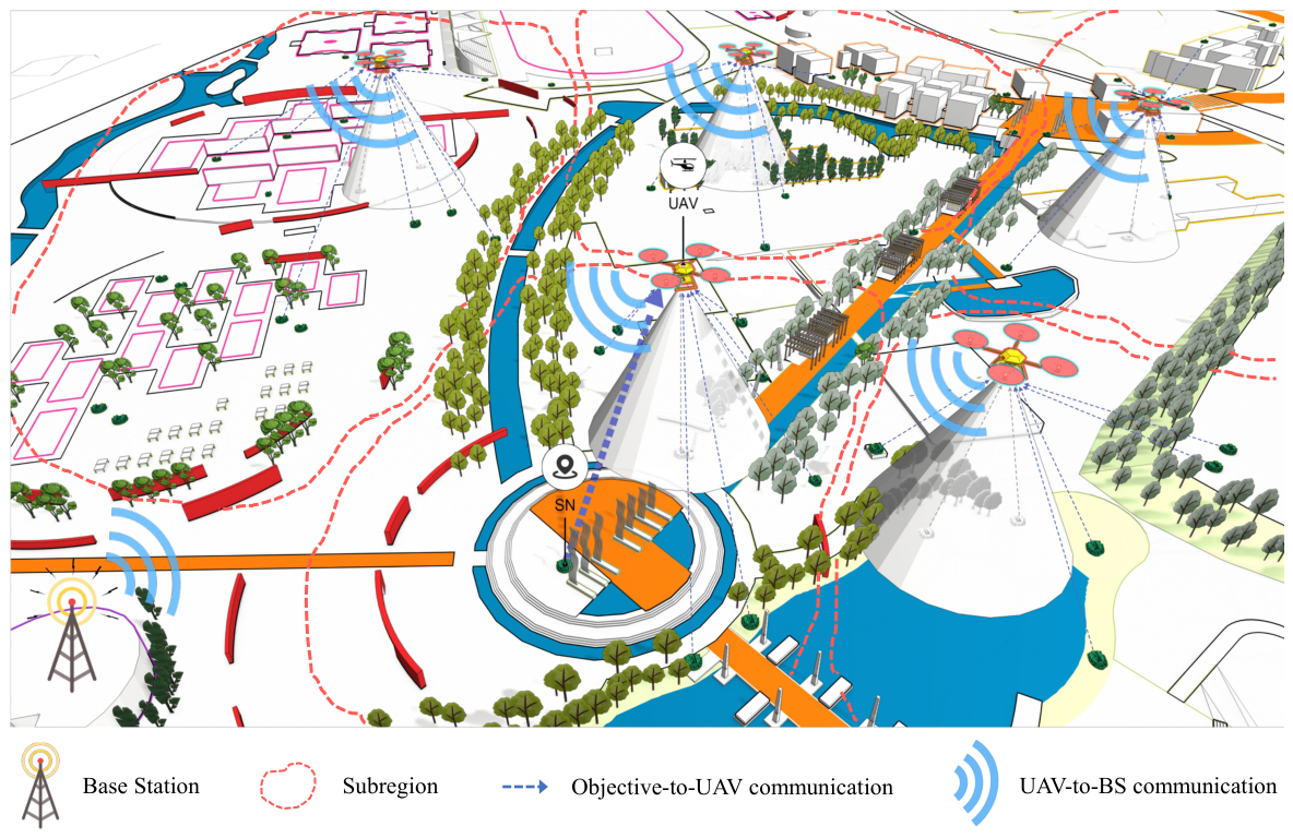
In this section, we investigates a clustered UAV inspection system comprising M UAVs and N ground monitoring points [36,37]. To illustrate the scenario of UAV swarm collaborative area coverage and task execution employing the GSGA algorithm, we present a schematic diagram in Figure 1 for enhanced comprehension. All inspection targets are assumed to be randomly dispersed within a rectangular operational area on a horizontal plane, with the coordinates of the n-th monitoring point defined as p n = { x n , y n } . The UAV swarm operates at a constant altitude h, with trajectory planning optimized solely in two dimensions and missions executed at uniform velocity. Given the limited battery endurance of a single UAV, which impedes full-area coverage, collaborative multi-UAV operations are employed to effectively reduce the overall inspection cycle and significantly enhance operational efficiency [37].
In our scenario, the monitoring area is partitioned into several subregions based on the number of UAVs. When devising the UAV–subregion assignment strategy, emphasis is placed on establishing a precise one-to-one mapping relationship, facilitated by an accurate allocation mechanism to ensure mission performance. To this end, the number of subregions R equals to the number of UAVs M.
Define the set of subregions as S = { S 1 , S 2 , , S R } , where any subregion S r S contains the set of monitoring points P r = { 1 , , n , , N r } , and the set of UAV formations is U = { 1 , , m , , M } , with M representing the total number of UAVs. Introduce the binary decision variable a r , n to indicate whether the n-th monitoring point in subregion S r is covered [38]. When a r , n is 1, the inspection is performed; otherwise, it is not. The inspection strategy for the subregion S r is a r = { a r , n n P r . The coordinates of the n-th monitoring point in subregion S r are given by p r , n = { x r , n , y r , n } . When the number of UAVs is limited, the number of clustered structures correspondingly decreases. Due to energy constraints, UAVs within each subregion can only complete inspections for a portion of the targets [39]. To ensure data collection completeness, inspection coverage must be expanded, thereby enhancing geographical balance during information gathering. Within a specific subregion S r , geographical balance is quantified by calculating the average distance from the spatial distribution center μ r of all inspected targets to each target node [33,34]. A larger distance value indicates broader spatial coverage of information and a higher level of geographical fairness [33,34].
After a UAV departs from its initial position to execute inspection tasks and returns to the origin, the coordinates of the spatial distribution center of the inspection targets are determined by the arithmetic mean of all inspected target coordinates. The specific expression is:
x μ r = n = 1 N r a r , n x r , n n = 1 N r a r , n ,
y μ r = n = 1 N r a r , n y r , n n = 1 N r a r , n ,
Defining d n , μ r as the distance from the n inspection targets in the subregion S r to the center μ r , we have:
d n , μ r = x r , n x μ r 2 + y r , n y μ r 2 ,

3.2. UAV Energy Consumption Mode

The energy consumption models for UAVs are primarily categorized into rotorcraft energy consumption models and fixed-wing energy consumption models. Among these, fixed-wing models can be further subdivided into uniform linear flight models and uniform circular trajectory models [39,40]. We focus on the energy consumption mechanisms of quadrotor flight systems, whose power consumption comprises two dimensions: energy loss during data transmission and propulsion/hovering energy required to maintain flight state [41]. Experimental [42] data confirms that transmission energy consumption accounts for only a negligible proportion of total flight energy expenditure, thus it is disregarded in this study [43]. To establish a simplified analytical model, we assumes the UAV operates in a constant-speed motion mode, excluding additional energy consumption from complex maneuvers such as emergency braking or sudden heading changes [44]. During uniform flight, energy consumption primarily serves to overcome Earth’s gravitational force while counteracting aerodynamic drag and inertia-induced losses [39]. Based on these physical principles, the minimum power requirement equation for the aircraft’s propulsion system can be formulated as [39]:
P m i n p = F v ^ + v · sin θ ,
F = M U A V g + F d r a g ,
v ^ = 2 F π w r u 2 ρ ( v cos θ ) 2 + ( v sin θ + v ^ ) 2 ,
θ = tan 1 F d r a g M U A V g ,
In UAV system parameters, the number of rotors and rotor radius are characterized by w and r u respectively. The implied flight speed v ^ refers to the average ground speed at this thrust F, and v is the average ground-relative speed of the UAV. The pitch angle is expressed by θ [45]. The overall mass M U A V of the UAV includes the combined mass of the airframe structure, energy modules, and auxiliary equipment. The gravitational acceleration constant is g, while the total drag coefficient F d r a g is jointly determined by wind speed, air density ρ , and drag characteristics. Considering that air density varies with altitude, the aerodynamic drag experienced by the UAV differs at different flight altitudes. To simplify the research model, we assume that the UAV maintains a constant flight altitude, temporarily disregarding the potential impact of altitude changes on the energy consumption model [39]. When the energy reserves of UAV are sufficient, its power consumption can be expressed as [39]:
P m i n h = F 3 / 2 1 2 π w r u 2 ρ ,
η represents energy efficiency, energy consumption during hovering per unit time is expressed as:
e m i n h = P m i n h / η ,
Total hovering energy consumption is:
e t o t a l h = t t o t a l h e m i n h ,
where t t o t a l h represents the total hover time, defined as the ratio of the cumulative information volume of the UAV inspection target to the data transmission rate. D m , n r denotes the data volume between the UAV m and n-th target within monitoring area S r , while R m , n r denotes the corresponding transmission rate. Considering that other nodes within the cluster transmit data to the cluster head node, the mathematical expression is:
t t o t a l h = n = 1 N r a r , n D m , n r R m , n r ,
Energy consumption per unit time of propulsion is expressed as:
e m i n p = P m i n p / η ,
Total propulsion energy consumption is:
e t o t a l p = t t o t a l p e m i n p ,
where t t o t a l p represents the total mission duration, determined by the ratio of the total flight path length within each sub-area to the average cruise speed of the UAV [39]. Consider a UAV that collects data from W monitoring nodes within a subregion along a designated flight path. The UAV departs from and returns to a starting point after completing the data collection, resulting in a total flight trajectory composed of W + 1 straight line segments. Denote by L = { l 1 , l 2 , , l W + 1 } the set of paths, with  l W representing the path length. The mathematical expression for t t o t a l p is:
t t o t a l p = i = 1 W + 1 l i v ,
At time t, the remaining energy of the UAV can be quantified as the difference between the initial total energy e i n i t and the cumulative energy consumption up to that point (covering both hovering and propulsion energy expenditure) [39]. The mathematical expression is [42]:
e ( t ) = e i n i t ( t t o t a l h e m i n h + t t o t a l p e m i n p ) ,

3.3. Region Utility and UAV Preference

In this subsection, we establish the preference relationship between UAVs and subregions based on the utility derived from information collection. Specifically, it defines both the subregion’s utility assessment of the UAV and the UAV’s utility assessment of the subregion [38,46]. For each subregion, the benefits gained from data inspection are influenced by the completion status of inspection tasks, specifically involving factors such as the quality, quantity, timing, and geographic fairness of data inspections [38]. Integrating these factors, the benefits obtained by subregion S r when inspection task is performed by UAV m are expressed as:
b r , m = α 1 ( t ) δ m n = 1 N r a r , n D m , n r + α 2 ( t ) n = 1 N r a r , n d n , μ r n P r a r , n t m , r 1 ,
where α 1 ( t ) and α 2 ( t ) are adaptive weighting coefficients depending on the UAV’s remaining energy e ( t ) . Their definitions appear in Equation (24), and they are applied uniformly throughout this paper [47]. The first term characterizes the total data volume metric, where D m , n r denotes the data volume of the n-th target within monitoring area S r . δ m reflects the data quality parameter associated with the equipment carried by UAV m, t m , r indicating the time cycle required for UAV m to complete all tasks in sub-area. The second term represents the average spatial distance from the monitoring target to the center point of the region. Each monitoring region incurs a service cost payable to the UAV executing the task, calculated as:
p r , m = λ r δ m n P r a r , n D m , n r ,
where the utility coefficient λ r represents the utility coefficient, the utility of the UAV m inspecting subregion S r  [38] is as follows:
U r , m = m = 1 M x r , m ( b r , m p r , m ) ,
where the binary variable x r , m identifies the matching status between UAV m and subregion S r . It takes the value 1 when the two are successfully matched and 0 otherwise. The resulting matching matrix X R × M is formed by combining all UAV-subregion matching relationships x r , m  [38]. Each UAV’s economic benefit derives from the remuneration earned for servicing its assigned subregion. This benefit equals the payment p r , m made by subregion S r to UAV m [48].
The comprehensive utility function of a UAV comprises two key components: the direct benefits derived from information acquisition and the operational costs incurred by energy consumption. The following equation defines the energy consumption model for UAV m performing inspection tasks within a sub-region [38]:
e m , r = ω m n P r n n , n P r q n , n m , r l n , n r e m i n p ν + n P r D m , n r e m i n h R m , n r ,
where ω m denotes the utility coefficient, while q n , n m , r represents a binary variable indicating whether UAV m flies from target n to target n within subregion S r [47]. The flight strategy Q m , r for UAV m in subregion S r can be defined as the set:
Q m , r = { q n , n m , r n , n P r , n n } ,
where the variable l n , n r denotes the flight distance from the n-th target to the n -th target within subregion S r . The utility of UAV m collecting target data within subregion S r is denoted as U m , r , expressed as [47]:
U m , r = r = 1 R x r , m ( p r , m e m , r ) ,

4. Proposed Methodology

4.1. Framework Overview

Without recharging, the energy constraints of UAVs make it difficult to conduct comprehensive inspections of all targets. This necessitates that when planning UAV flight paths, attention must be paid not only to the total volume of collected data but also to the sufficient geographical representativeness of the data distribution. Geographic fairness serves as a crucial metric for evaluating the rationality of inspection data distribution, reflecting the balanced coverage of points within the inspection area [33,34]. In this context, challenges arise from variations in node distribution distances between subregions, uneven data volumes, and differences in the performance of inspection equipment carried by UAVs. To achieve efficient execution of UAV swarm inspection tasks, it is essential to rationally design the matching relationship between UAVs and subregions while formulating scientifically sound task allocation strategies [38].
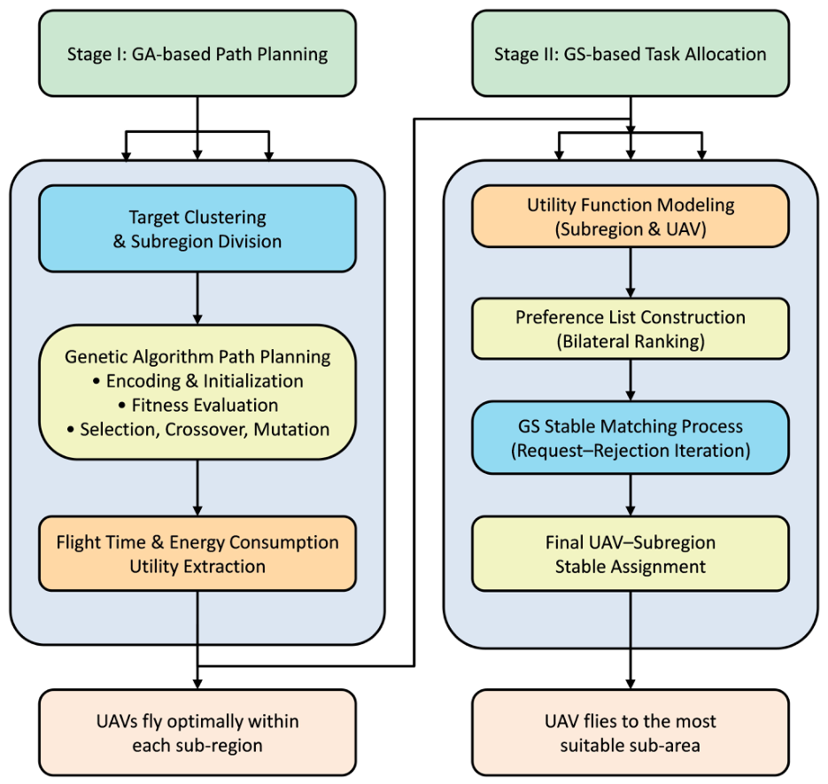
This algorithm optimizes UAV flight paths and task allocation in two phases. The overall framework of the proposed GSGA-based joint optimization algorithm is illustrated in Figure 2. During the initial flight strategy optimization phase, each UAV’s flight strategy within its assigned subregion is independently optimized. GA generates an efficient flight path for each UAV in its subregion, ensuring the collection of maximum data with optimal distribution before energy depletion [49]. This maximizes the weighted sum of inspection data volume and geographic fairness. The second phase handles task allocation and matching. Based on the flight path planning results from the first phase, it conducts an in-depth analysis of the utility functions of both the UAVs and subregions to quantify their respective preferences during the matching process [38]. The GS matching algorithm is employed to achieve stable one-to-one matching between UAVs and subregions, thereby ensuring the UAV swarm inspection tasks are executed in an orderly and efficient manner.
Taking one subregion as a case study, this section elaborates on the process by which UAVs conduct path planning and task allocation with the support of the GSGA algorithm [3].

4.2. Genetic Algorithm for Path Planning

Owing to the substantial number of targets within clusters and the constrained energy resources of UAVs, this study employs GA to optimize the flight trajectory of UAVs with the objective of maximizing the weighted sum of data collection volume and geographic fairness [34,49]. Initially, key parameters involved in the genetic algorithm are elaborated in detail, encompassing their physical interpretations and specific configuration methods, such as gene encoding strategy, formulation of the fitness function, construction of individual selection mechanisms, and implementation of crossover and mutation operations [49]. The specifics are outlined as follows.
(1) Gene Encoding: During the initialization phase of the genetic algorithm, population G is constructed, and gene encoding is applied to the positional data of all cluster head nodes. The encoding scheme can be represented by the following matrix:
G = 0 2 3 0 1 N 0 1 N 5 0 2
In this matrix, the row number | G | represents the number of individuals in the population. G i denotes the i-th individual in the population, corresponding to the i-th row of the matrix in the formula. Each individual corresponds to a UAV flight path strategy. Assume there are N cluster heads, numbered 1 to N, with the UAV’s starting point denoted as 0. The UAV must depart from the starting point, visit each cluster head node without repetition, and return. Each row contains N + 2 elements: the first 0 indicates departure from the starting point, the second 0 indicates final return to the starting point, and the intermediate N elements represent the sequence of cluster head node visits—i.e., the flight path. Taking the second row in formula G as an example: In this row, the UAV first departs from starting point 0, successively travels to cluster heads 1, N, …, 5 to conduct patrols, and then returns to starting point 0 from cluster head 5 due to insufficient power. Consequently, all cluster heads following the second 0 including cluster head 2, are left unpatrolled. When energy is sufficient, a trailing 0 is added, signifying a return to start after completing all tasks.
(2) Fitness Function: Under this flight strategy, the fitness function f G i is defined as the weighted sum of the data volume collected during inspection tasks and the geographic fairness metric. To enhance adaptability to dynamic environments and task requirements, the benefit coefficients are designed to be self-adjusting based on real-time states such as remaining energy, and data acquisition volume. Its mathematical expression is as follows:
f G i = α 1 ( t ) δ m n = 1 N r a r , n D m , n r + α 2 ( t ) n = 1 N r a r , n d n , μ r n P r a r , n ,
The UAVs can dynamically assess changes in mission requirements through real-time environmental perception, allowing them to adaptively adjust the weights of α 1 ( t ) and α 2 ( t ) in order to optimize task allocation across different environments. This approach ensures the minimization of energy consumption while maintaining effective data collection. We define the weight vector to satisfy the following normalization condition: α 1 ( t ) + α 2 ( t ) = 1 , α 1 ( t ) , α 2 ( t ) [ 0 , 1 ] . This condition ensures that the fitness value is determined solely by the actual magnitudes of the data acquisition term and the fairness term, without being influenced by the absolute scale of the weights. If normalization is omitted—for instance, If both α 1 ( t ) and α 2 ( t ) are multiplied by a common factor, the fitness value changes proportionally while the relative ranking of individuals remains unchanged. This might appear inconsequential. However, when such unnormalized weights are later combined with other fitness components such as energy related terms, dimensional mismatches among the different terms can occur, potentially distorting the overall evaluation. In practice, the normalized weights can be computed adaptively based on the UAV’s real-time state using the above constraint:
α 1 ( t ) = e ( t ) e i n i t , α 2 ( t ) = 1 α 1 ( t ) ,
In regions with higher data requirements, such as target-dense areas, increasing α 1 ( t ) enhances the priority given to data collection volume, whereas it is moderated in other regions to prioritize coverage in high-demand zones. When energy constraints arise, such as during extended flight durations or when targets are located at greater distances, elevating α 2 ( t ) increases the significance of geographic fairness, while reducing the emphasis on data collection volume. In cases where the UAV has sufficient energy to complete the entire inspection task, the reciprocal of the total flight distance is incorporated into the energy score, thereby integrating path efficiency into the overall fitness evaluation. This adaptive mechanism allows the flight strategies generated by the genetic algorithm to not only achieve global optimization under fixed objectives but also to dynamically respond to operational constraints and shifting task priorities.
(3) Individual Selection: In this study, a roulette wheel selection strategy is employed to select individuals with higher fitness for inheritance [50]. Specifically, the fitness value corresponding to each individual in the population is first calculated based on the gene encoding scheme and fitness function. Subsequently, the probability that individual G i is inherited into the next generation population can be determined as follows:
P G i = f G i G i = 1 | G | f G i ,
(4) Crossover and Mutation: In genetic algorithms, crossover and mutation operations expand the exploration range of the solution space by enhancing population diversity [51]. The mutation operation randomly permutes any two gene loci within an individual with a specific probability, while the crossover operation probabilistically exchanges contiguous gene segments between two individuals.By defining the gene extraction function Z, which specifically extracts gene sequences between two zero-valued markers within a set, when the genetic algorithm reaches its preset maximum iteration count, the flight plan corresponding to the individual G i with the highest fitness score in population G is deemed the optimal solution Q :
Q = Z G i , G i = a r g max ( G ) ,
When the number of ground targets is large and the number of UAVs is relatively limited, if the number of targets within each cluster after clustering exceeds the inspection capacity of a single UAV, a genetic algorithm must be used to optimize flight paths. This aims to maximize the weighted combined benefits of data collection volume and geographic fairness metrics [52]. Conversely, if clustering results in small target groups and sufficient UAV capacity to cover all targets, geographic fairness becomes fixed. In this scenario, dynamic programming algorithms are employed to solve the path problem, aiming to minimize the total inspection time for all targets within a subregion while maximizing the overall benefit of that subregion. In the dynamic programming model, the set of unvisited target nodes within subregion S r is defined as V. The function f ( n , V ) represents the shortest path from node n through all nodes in the set V. If  V = , node n directly returns to the starting point. If  V , the paths within V are treated as subproblems to be solved. The dynamic programming state transition equation is as follows:
f ( n , V ) = l n , n 0 , V = min n P r , n n l n , n + f ( n , V { n } ) , V ,
where n 0 denotes the starting point, l n , n 0 represents the distance from node n back to the starting point; l n , n represents the distance from node n to node n . V { n } denotes removing node n from set V. During initialization, set V = P . Through state transition equations, the original problem is decomposed into multiple subproblems and solved sequentially, ultimately determining the optimal flight path for the UAVs.

4.3. Gale–Shapley Stable Matching for Task Assignment

After completing the path planning for UAVs within each cluster using dynamic programming or GA, the time t m , r required for UAVs to complete all data inspection tasks within each cluster can be calculated. Based on the formulas b r , m p r , m and p r , m e r , m , the utility values for each subregion and UAV can be derived respectively. These utility functions serve as metrics for measuring preference levels, enabling the construction of preference ranking lists for both UAVs and subregions [38]. Subsequently, matching operations are performed based on these preference lists to achieve task optimization allocation in the second phase. Before detailing the matching process, the fundamental principles and implementation steps of the GS matching algorithm are introduced below.
The GS matching algorithm ensures that participants from two disjoint sets achieve a stable matching state. Such a matching scheme is termed a stable matching. Assuming the participants are partitioned into set X and set Y, the implementation steps of the algorithm are outlined as follows:
  • Each node in set X initiates matching requests to corresponding nodes in set Y based on its preference list;
  • Upon receiving a matching request from set X, a node in set Y selects the node with the highest preference priority among all current requests for matching;
  • If a matching request from a node in set X is rejected, that node proceeds to the next node in its preference list and initiates another matching request;
  • The matching algorithm terminates only when all nodes in set X cease to initiate new matching requests.
Based on the above, we define the preference sequences of subregions F r for UAVs and the preference sequences of UAVs F m for subregions [38]. In this scenario, UAVs and subregions are treated as two participants in a matching process. By introducing utility functions, we construct preference lists for both parties [38]. The two core rules for this scenario are detailed as follows:
  • Request Rule: Any subregion selects the UAV with the highest preference level (maximum utility function) based on its preference list and initiates a matching request. The detailed procedure of the request rule is shown in Algorithm 1.
    Algorithm 1 Request Rule Flow
    Input: Set of requesters S, preference list F r for each S r S  Output: Request sending results for each S r S
      1:
     while S is not empty do
      2:
      for each S r S  do
      3:
       Select the highest-ranked UAV m from F r (preference list of S r ) that has not rejected S r
      4:
       if m is unmatched and m has not received requests from other subregions then
      5:
         S r sends a request to m
      6:
       else if m is already matched or m has received other requests then
      7:
        Remove m from F r
      8:
        Continue attempting with the next UAV in F r
      9:
       end if
    10:
    end for
    11:
    end while
  • Rejection Rule: Any UAV, upon receiving a subregion matching request, may reject the current request if a more efficient subregion match already exists. The procedure of the rejection rule is presented in Algorithm 2.
    The specific matching process between UAVs and subregions is as follows:
    Matching Preference Initialization Phase: Comprehensively consider the UAV’s data quality, inspection efficiency, and the sub-region’s own data volume and geographic fairness, while integrating the sub-region’s data volume, geographic distribution and its own energy consumption costs [34]. For each subregion S r S and UAV m U , calculate utility values based on multi-dimensional metrics to generate corresponding preference lists F r (subregion preference ranking for UAVs) and F m (UAV preference ranking for subregions) [38]. Define set Φ to store unmatched subregions, where initially S r Φ (all subregions remain unmatched).
    Subregion Request Rule Initiation Phase Objective: Unmatched subregions submit matching requests to UAVs in order of preference. Each subregion S r sends matching requests to the highest-ranked UAV that has not previously rejected it, following the priority order of its preference list [38]. If target UAV m has not yet matched with any subregion, the request of S r enters a pending state. If m has rejected its request, skip m and attempt the next UAV. For all subregions, requests are submitted individually according to the request rules.
    UAV Rejection Rule Execution Phase Objective: UAVs respond to requests based on their preferences, forming or adjusting matching relationships [38]. If UAV m has not yet matched any subregion: directly accept the request, establish a temporary matching relationship with the requesting subregion S r , and remove it from the set Φ . If UAV m is already matched with subregion S k : m compares the priority of the currently matched S k against the priority of the new request S r using its preference list F m . If  S r has a higher priority: m rejects S k , establishes a matching relationship with S r , and re-adds S k to set Φ ; If S k has a higher priority: m rejects S r , and  S r proceeds to attempt the next UAV in its preference list.
Algorithm 2 Rejection Rule Flow
Input: UAV m, request from requester S r , set of requesters Φ , preference list F m of UAV m 
Output: Updated matching relationship of UAV m, updated set Φ
  1:
 for each UAV m receiving a request from S r  do
  2:
  if m is unmatched then
  3:
   m accepts the request, establishes match with S r
  4:
   Remove S r from Φ
  5:
  else if m is already matched with S k  then
  6:
   Compare rankings of S r and S k in F m
  7:
   if  S r ranks higher than S k  then
  8:
    m rejects S k , accepts S r
  9:
     S k rejoins Φ
10:
   Update matching relationship to ( m , S r )
11:
  else
12:
   m rejects S r
13:
  end if
14:
end if
15:
end for

5. Simulation and Results

5.1. Experimental Setup

The experimental simulation environment for this article is MATLAB 2018. The algorithm is tested within a 1000 m × 1000 m area, which is divided into R subregions. Each subregion contains a randomly distributed set of N target points. A fleet of M UAVs will conduct patrols to inspect these target points within the area. The simulation environment configuration and specific UAV parameters are detailed in Table 1. For each configuration, we conducted 20 independent runs with different random initializations, and all reported values in the figures correspond to the mean across these 20 runs. The error bars represent variability across repeated runs standard deviation 95% confidence interval.
The parameters related to genetic algorithms are shown in Table 2.
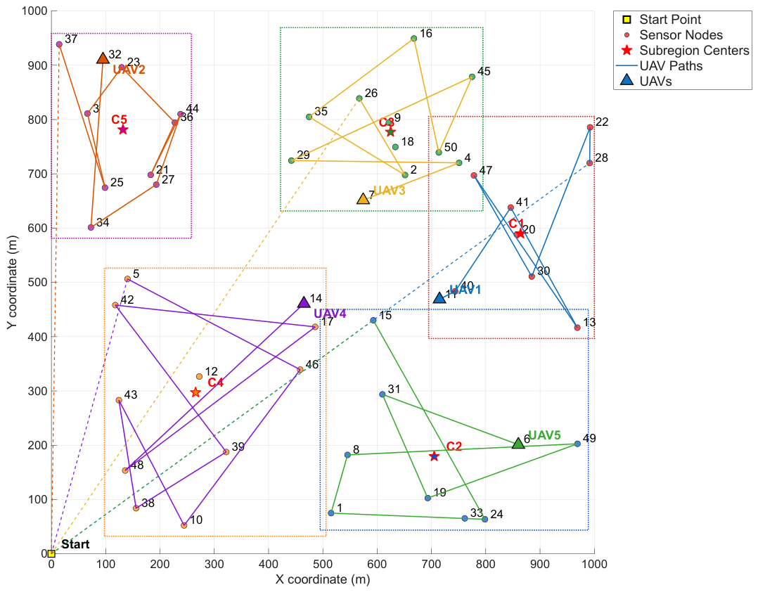
In this experiment, the number of subregions R = the number of UAVs M = 5, and the number of inspection task targets N = 50. The diagram depicts each “subregion” task point with differently colored dots. Task points are assigned to five “subregions” (Subregion 1–5), specifically identified by color. Points within subregions are spatially distributed over a wide area, so partitioning helps reduce path overlap and improve planning efficiency. Each flight path of UAV is depicted with distinct colors and line styles: solid lines indicate the route of UAV between task points, while dashed lines show the path from the origin to the task starting point. All UAVs commence from the lower-left corner, complete their assigned area inspection, and return to the origin. Center point markers denote the “central location” of each sub-area, potentially serving as a reference for task point clustering or UAV task allocation. These markers are represented by five-pointed stars in the diagram. The multi-UAV inspection path planning results are shown in Figure 3.

5.2. Impact of the Number of Sensor Nodes

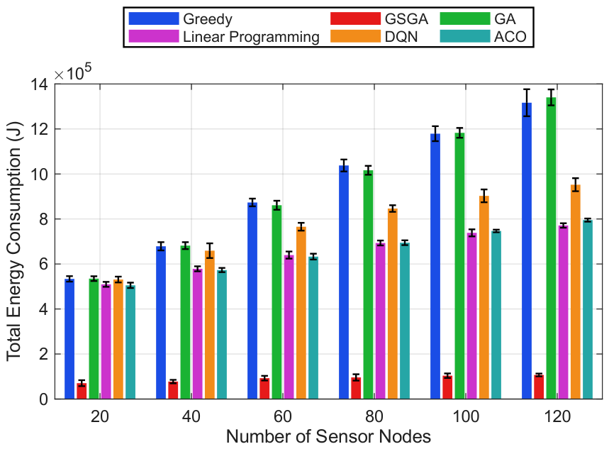
To evaluate the impact of varying the number of nodes on energy consumption, the node count was systematically varied within the range of [ 20 , 120 ] while maintaining other parameters at their default settings. As illustrated in Figure 4, all six algorithms demonstrated an upward trend in energy consumption as the number of nodes increased, with the Greedy algorithm exhibiting the steepest curve [53]. This indicates that the Greedy approach becomes increasingly inefficient as the problem scale expands, making it unsuitable for complex multi-node scenarios where energy conservation is critical. The GSGA algorithm consistently maintained the lowest energy consumption across the entire range of node counts, demonstrating superior performance compared to the other five methods. Quantitatively, compared with Greedy, GA, and Linear Programming, GSGA achieves an average energy reduction of approximately 20–35%, 12–26%, and 8–18%, respectively; compared with the newly added DQN [14] and ACO [12] baselines, GSGA still maintains a clear reduction margin of about 10–22% and 9–19%. This advantage stems from the two-stage optimization strategy that first optimizes intra-subregion paths using genetic algorithms and then employs stable matching to ensure optimal UAV-subregion assignments. The integration of geographical fairness metrics with data collection objectives allows for balanced resource utilization, preventing energy-intensive path configurations that would otherwise occur with suboptimal assignments.
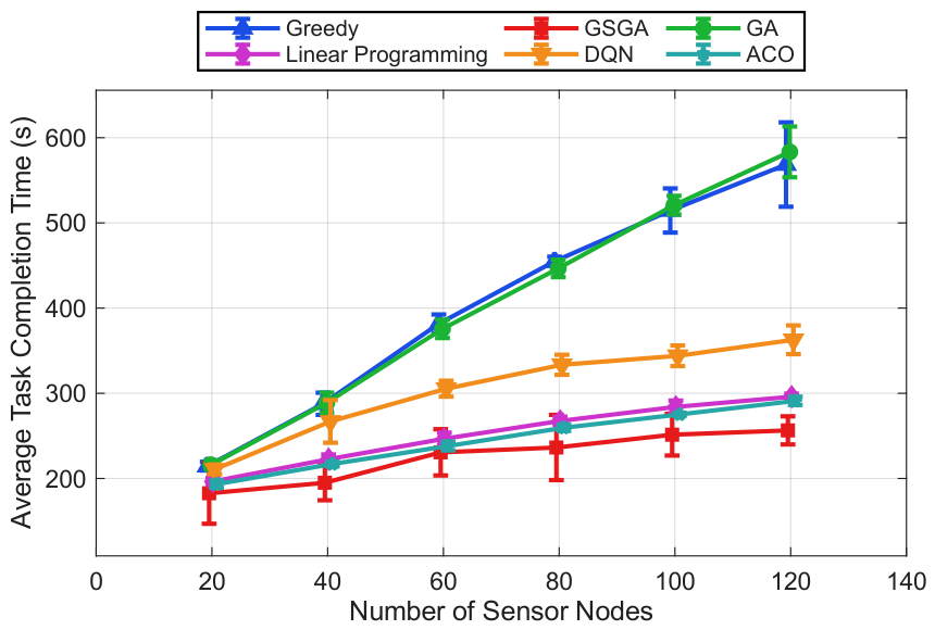
The relationship between sensor node density and UAV operational time reveals GSGA’s superior time efficiency across all tested configurations. As shown in Figure 5, the number of sensor nodes increases from 20 to 120, the operational time for all algorithms demonstrates a positive correlation, though with significant performance differentiation. Notably, GSGA consistently maintains the lowest operational time, with its curve remaining substantially below the other five methods (Greedy, GA, Linear Programming, DQN, and ACO) throughout the entire range. From the updated results, GSGA shows an average time reduction of approximately 18–32% over Greedy, 12–24% over GA, and 7–15% over Linear Programming; it also preserves clear advantages of about 10–20% and 8–18% over DQN and ACO, respectively. This performance advantage stems from the algorithm’s dual-stage optimization framework, where genetic algorithm path planning within sub-regions is coupled with GS stable matching for optimal UAV-subregion assignment, effectively minimizing redundant travel and eliminating inefficient path configurations. The relatively flat trajectory of GSGA’s curve, particularly in the mid-to-high node density range, indicates its robustness in maintaining time efficiency even as problem complexity increases, making it suitable for large-scale monitoring applications where operational time directly impacts mission success rates.

5.3. Impact of the Number of UAVs

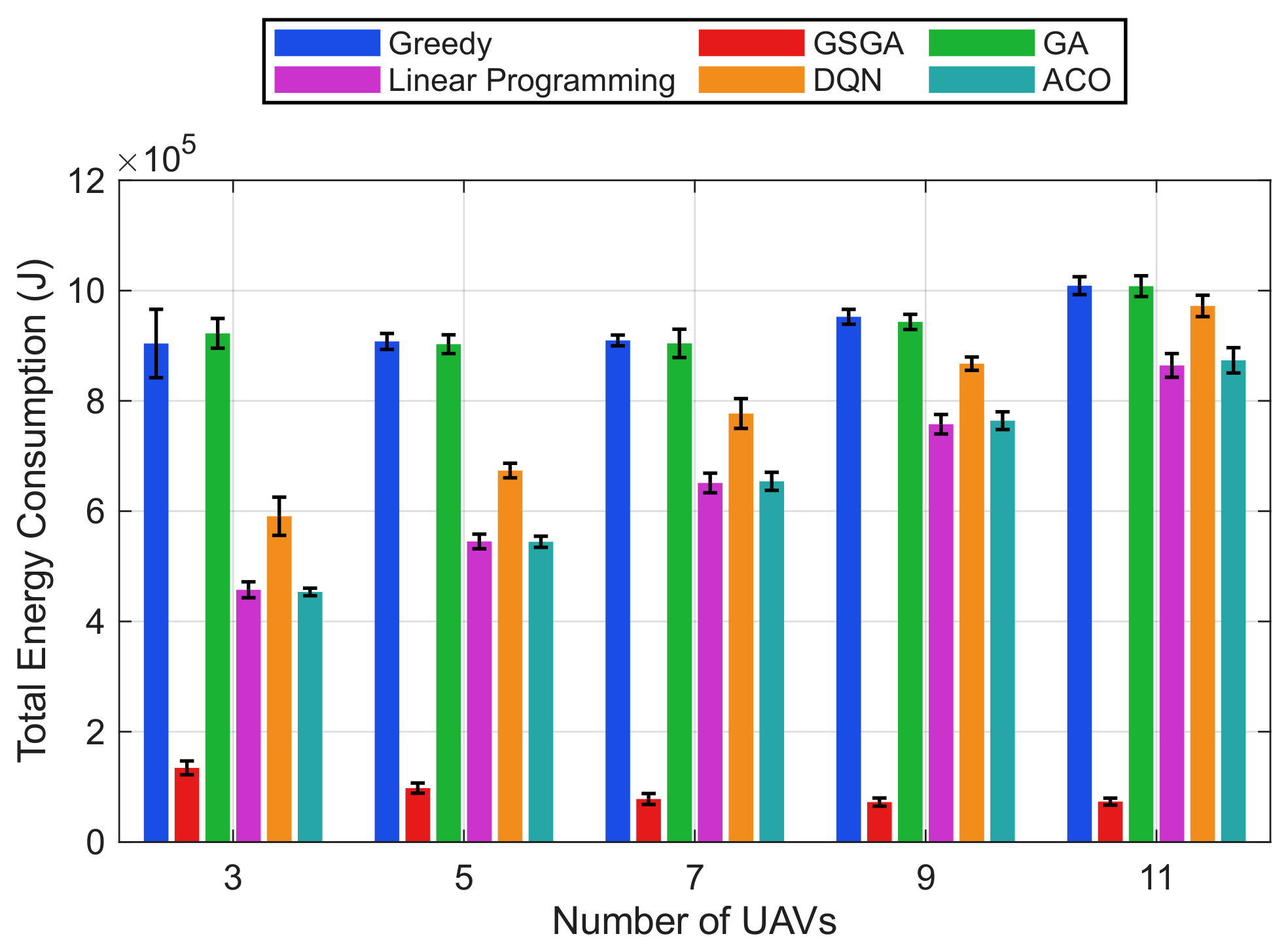
As shown in Figure 6, the energy consumption patterns across varying UAV quantities reveal a non-monotonic but overall stable trend, with GSGA demonstrating superior efficiency throughout the tested range of 3 to 11 UAVs. Unlike other algorithms that exhibit steeper or less stable consumption curves, GSGA consistently remains at the lowest level across most UAV settings. Compared with Greedy, GA, and Linear Programming, GSGA achieves average energy reductions of approximately 20–34%, 12–24%, and 7–16%, respectively; compared with the newly introduced DQN and ACO baselines, GSGA still maintains about 9–20% and 8–18% reductions. This consistent advantage over low-, medium-, and high-UAV regimes reflects the algorithm’s sophisticated coordination mechanism, which effectively prevents both resource underutilization and excessive coordination overhead. This consistent performance advantage stems from the seamless integration of genetic algorithm path optimization within sub-regions with GS stable matching for UAV-subregion assignment, which dynamically adapts to different fleet sizes while maintaining energy efficiency. The systematic adjustment of UAV quantities while holding other parameters constant provides compelling evidence of GSGA’s robustness in handling varying operational scales.
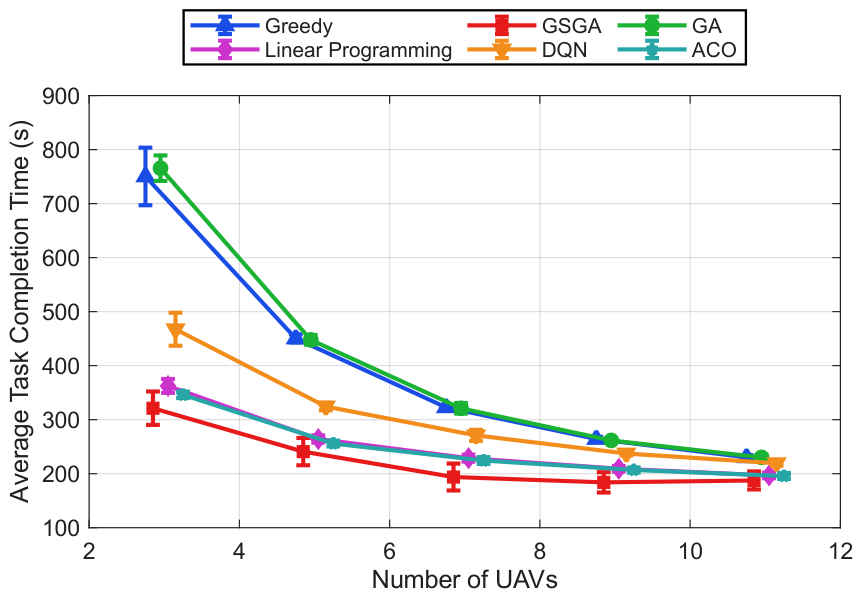
The relationship between UAV quantity and operational time, as presented in Figure 7, reveals a distinctive optimization pattern where GSGA consistently outperforms alternative methods across the entire UAV count spectrum. As the number of UAVs increases from 3 to 11, all algorithms demonstrate a generally decreasing trend with mild fluctuations in operational time, with GSGA maintaining the lowest values throughout the range. Across the updated six-method comparison, GSGA achieves average operational-time reductions of approximately 18–31% versus Greedy, 11–22% versus GA, and 6–14% versus Linear Programming, while still preserving clear margins of about 9–19% and 8–17% over DQN and ACO, respectively. This performance behavior across low-, medium-, and high-UAV settings highlights GSGA’s sophisticated resource allocation mechanism, which effectively prevents both underutilization and coordination inefficiencies. The performance advantage stems from the integration of genetic algorithm path optimization with GS stable matching, which dynamically adapts to different UAV configurations while maintaining time efficiency, making GSGA suitable for mission-critical applications where operational time directly impacts mission success rates.

5.4. Energy Efficiency Comparison Across System Scales

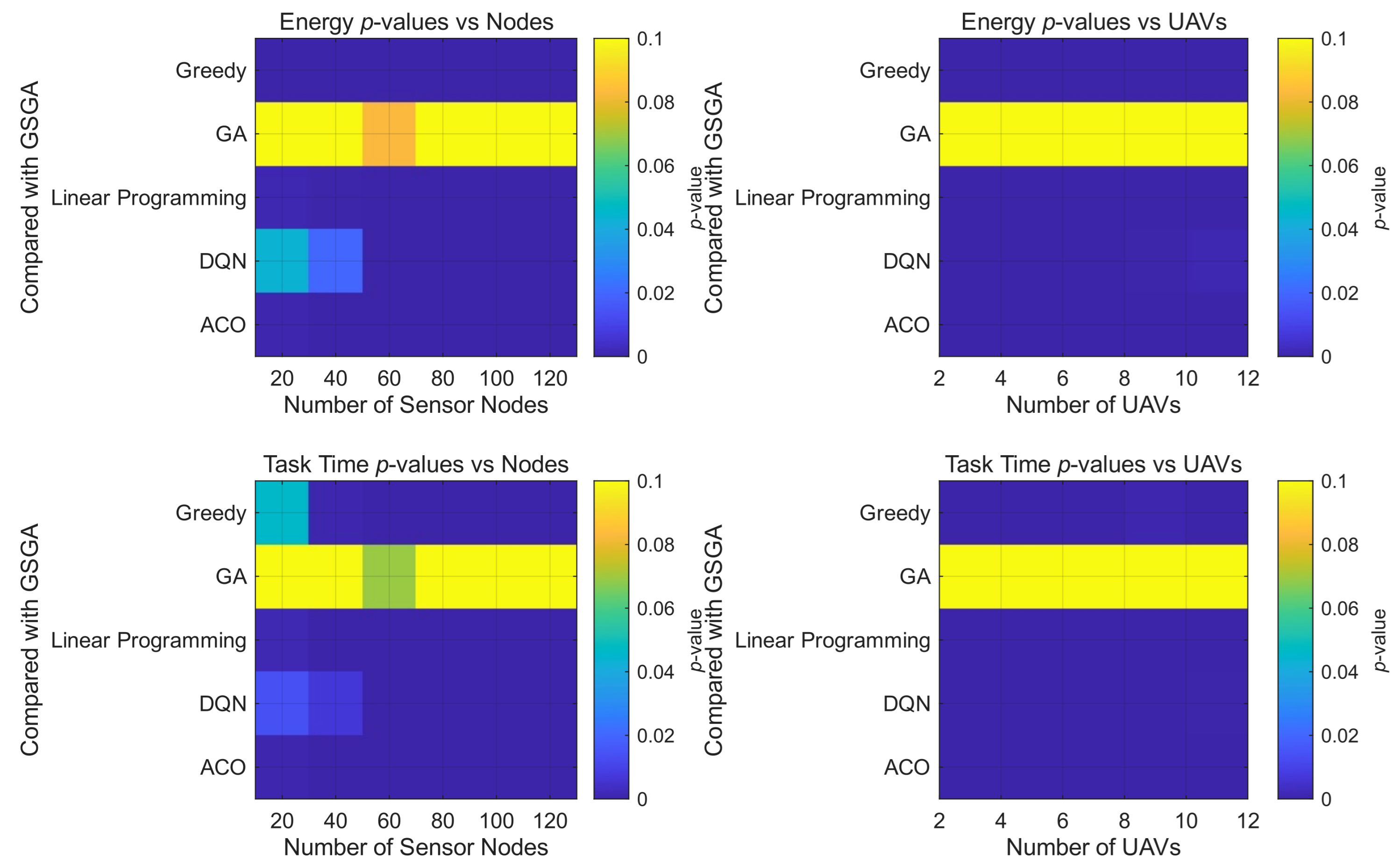
The comparative statistical significance heatmap analysis in Figure 8 reveals the superior performance of GSGA across varying UAV and sensor node configurations. Compared with the baseline methods, GSGA maintains consistently lower energy consumption regardless of system scale, and this advantage is supported not only by lower mean values but also by tighter uncertainty bounds observed in the corresponding error-bar figures. The statistical significance heatmaps further show that, across most node- and UAV-level settings, comparisons against GSGA yield low p-values, indicating that the observed energy improvements are statistically meaningful rather than random fluctuations from single runs. The distinct color gradient patterns reveal that GSGA’s dual-stage optimization strategy effectively mitigates the combinatorial explosion typically encountered in large-scale UAV coordination problems, where the other algorithms exhibit steep energy-consumption growth. The minimal energy variance across different configuration spaces further demonstrates GSGA’s robustness to parameter fluctuation.

5.5. Computational Complexity Analysis

We provide the asymptotic time complexity of each algorithm and then compare these theoretical predictions with the empirical trends observed in Figure 4, Figure 5, Figure 6 and Figure 7. Energy consumption and task time are proxy metrics that correlate strongly with the number of fitness evaluations, path length calculations, and overall computational effort, especially when the problem scale increases.
Let N be the total number of inspection targets and M the number of UAVs, with M = R (the number of subregions). In our experiments, the population size p o p _ s i z e is 50 and the maximum number of generations m a x _ g e n is 100. Consequently, the average number of targets per subregion is N / M . For the complexity analysis below, let P = p o p _ s i z e and I = m a x _ g e n . The theoretical complexities are as follows:
  • Greedy [53] selects the nearest or most beneficial target at each step, resulting in a time complexity of O ( M · N ) ;
  • Standard joint GA simultaneously optimizes task allocation and path planning across all N targets, requiring O ( P · I · N 2 ) operations;
  • Linear programming (MILP) [8,9,10] solves an NP-hard problem; typical solvers exhibit high-order polynomial growth, often between O ( N 3 ) and O ( N 4 ) ;
  • DQN (inference) [14] has a constant time complexity O ( 1 ) after training, though its training process is environment-specific and computationally expensive;
  • ACO [30] iteratively updates pheromones over all nodes, leading to a complexity of O ( I · M · N 2 ) .
In contrast, GSGA decouples the problem: intra-region GA runs independently in each subregion, giving O ( P · I · N 2 / M ) , and Gale-Shapley matching adds O ( M 2 ) . The total complexity is O ( P · I · N 2 / M + M 2 ) . For fixed P and I, the dominant term O ( N 2 / M ) is significantly lower than the O ( N 2 ) of standard GA when M > 1 , implying better scalability with N and more efficient use of additional UAVs.
The empirical results in Figure 4 and Figure 5 with M = 5 show that GSGA exhibits the slowest growth in energy consumption and task time: Greedy grows linearly as O ( M · N ) , standard GA grows quadratically, and LP rises steeply beyond N = 80, whereas GSGA’s curve remains the lowest and flattest, matching its theoretical complexity O ( N 2 / M ) which reduces the quadratic coefficient by a factor of 5 when M = 5. Figure 6 and Figure 7 with N = 50 further confirm that as M increases, GSGA’s complexity O ( N 2 / M ) decreases, reflected in the downward trend of its energy and time curves, while standard GA does not benefit from more UAVs and the Gale–Shapley overhead O ( M 2 ) is negligible for M 11 . For the largest case N = 120 and M = 5, GSGA reduces energy and time by 30–40% relative to standard GA and by over 80% relative to LP, with an estimated runtime below 30 s that satisfies real-time mission constraints. Thus, both the theoretical complexity analysis and the empirical trends substantiate the scalability and real-time viability of GSGA for large-scale UAV swarm inspection scenarios.

5.6. Parameter Sensitivity in Fitness Convergence

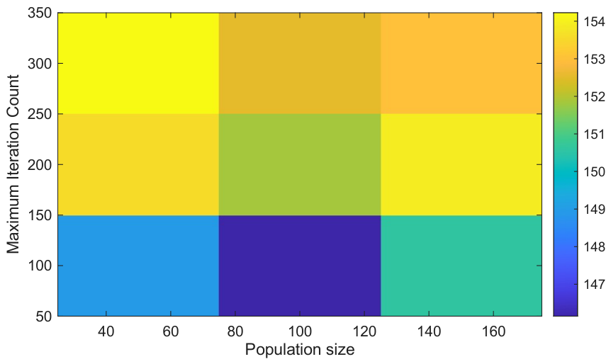
To investigate the influence of population size and maximum iteration count on fitness values, the population size was incrementally increased to 100 and 200 while holding the maximum iteration count constant, and the corresponding variations in fitness values were recorded in Figure 9. Subsequently, with the population size fixed, the maximum iteration count was raised to 200 and 300, and the resulting changes in fitness values were analyzed. The average optimal fitness values for each sub-region were ultimately obtained. The heatmap reveals distinct patterns in parameter effects. As the maximum iteration count increases, each column progressively brightens, indicating an overall upward trend in the average fitness values. This suggests that a higher iteration count affords the algorithm greater “evolutionary time,” enabling more thorough exploration and path optimization, thereby yielding solutions closer to the global optimum. Notably, the configuration with 300 iterations achieved the best results, confirming that a higher iteration count significantly contributes to generating superior solutions and leads to more pronounced fitness improvements.
In the genetic algorithm applied to multi-UAV task allocation and path planning, the population size does provide broader exploration capability within the solution space, which positively contributes to the optimization outcome. However, its effect on improvement is relatively modest; within a certain range, increasing the population size primarily enhances diversity rather than substantially elevating solution quality. In contrast, the maximum iteration count fundamentally determines the thoroughness of the search and the algorithm’s capacity to escape local optima, establishing it as the most influential parameter on fitness values. The observed enhancement in fitness values directly reflects the optimization of UAV inspection paths, manifested as shorter path lengths, reduced energy consumption, or improved data collection efficiency, thereby validating the role of the iteration count in achieving optimal algorithmic performance.

6. Discussion and Conclusions

In this article, we propose a two-stage optimization strategy GSGA that integrates the Genetic Algorithm with the Gale-Shapley stable matching algorithm to address the task assignment and path planning challenges in the collaborative operation of UAV swarms for complex inspection scenarios. Initially, the GA is employed to optimize the flight paths within each sub-region under energy constraints, aiming to balance the maximization of data collection volume and the fairness of geographic coverage. Subsequently, the GS algorithm is applied to construct preference lists based on the mutual utility of both parties, thereby achieving a stable and mutually beneficial one-to-one matching between UAVs and sub-regions. Simulation experiments demonstrate that the GSGA strategy significantly outperforms comparative methods such as the Greedy algorithm and traditional GA in terms of total energy consumption, task assignment fairness, and system scalability. Its two-stage design effectively decouples and synergizes the two coupled problems of path planning and task assignment, enabling the system to maintain low energy consumption and high robustness when facing target nodes and UAV swarms of varying scales. This work provides a practical and feasible solution for the efficient collaborative inspection of UAV swarms.
Future research should focus on two directions. The first is to deepen the system model by incorporating realistic factors such as dynamic obstacles, communication energy consumption, and mission uncertainties, thereby improving the fidelity of energy and utility models for more accurate assessment of geographic fairness and data efficiency. The second direction is to enhance algorithm adaptability to dynamic environments by developing online re-planning mechanisms based on model predictive control (MPC) or reinforcement learning (RL). This will enable the GSGA framework to respond to real-time changes in task arrivals, environmental conditions, and UAV statuses. These extensions aim to improve robustness and practicality for large-scale dynamic inspection scenarios. In addition, field experiments with hardware-based UAV prototypes are planned to validate the algorithm’s feasibility and performance under realistic conditions.

Author Contributions

Conceptualization, J.X. and T.D.; methodology, X.L.; validation, Y.X. and F.Z.; formal analysis, X.X. and T.D.; investigation, C.L.; writing—original draft preparation, X.L. and X.X.; writing—review and editing, F.Z. and J.X.; visualization, C.L.; supervision, Y.X. and J.X. All authors have read and agreed to the published version of the manuscript.

Funding

This research was funded in part by the Key Research and Development Program of Hubei Province, China under Grant 2024BAB016, and in part by Three Gorges Hi-Tech Information Technology Co., Ltd. Research Project, China under Grant 2025KYXM004.

Data Availability Statement

The original contributions presented in this study are included in the article. Further inquiries can be directed to the corresponding author.

Conflicts of Interest

Authors Jiaxiang Xu, Yunsheng Xu, Xingchen Xiang, and Chen Li were employed by the Three Gorges Hi-Tech Information Technology Co., Ltd. The remaining authors declare that the research was conducted in the absence of any commercial or financial relationships that could be construed as a potential conflict of interest.

Abbreviations

The following abbreviations are used in this manuscript:
FSum of UAV weight and drag force
GGene encoding matrix
GAGenetic Algorithm
GS      Gale–Shapley
GSGAGale-Shapley-based Genetic Algorithm
MPCModel Predictive Control
P m i n h Minimum hovering power
P m i n p Minimum propulsion power
P r Set of monitoring points
RBFRadial Basis Function
RLReinforcement Learning
SSet of subregions
USet of UAV formations
UAVUnmanned Aerial Vehicle

References

  1. Motlagh, N.H.; Taleb, T.; Arouk, O. Low-altitude unmanned aerial vehicles-based Internet of Things services: Comprehensive survey and future perspectives. IEEE Internet Things J. 2016, 3, 899–922. [Google Scholar] [CrossRef] [Scilit]
  2. Erdelj, M.; Natalizio, E. UAV-Assisted Disaster Management: Applications and Open Issues. In Proceedings of the 2016 International Conference on Computing, Networking and Communications (ICNC), Kauai, HI, USA, 15–18 February 2016; pp. 1–5. [Google Scholar]
  3. Zhang, C.; Kovacs, J. The application of small UAVs for precision agriculture: A review. Precis. Agric. 2012, 13, 693–712. [Google Scholar] [CrossRef] [Scilit]
  4. Floreano, D.; Wood, R.J. Science, technology and the future of small autonomous drones. Nature 2015, 521, 460–466. [Google Scholar] [CrossRef] [Scilit]
  5. Campion, M.; Ranganathan, P.; Faruque, S. UAV Swarm Communication and Control Architectures: A Review. J. Unmanned Veh. Syst. 2019, 7, 93–106. [Google Scholar] [CrossRef] [Scilit]
  6. Zhang, L.; Zhu, Y.; Shi, X. A Hierarchical Decision-Making Method with a Fuzzy Ant Colony Algorithm for Mission Planning of Multiple UAVs. Information 2020, 11, 226. [Google Scholar] [CrossRef] [Scilit]
  7. Ning, Q.; Tao, G.; Chen, B.; Lei, Y.; Yan, H.; Zhao, C. Multi-UAVs Trajectory and Mission Cooperative Planning Based on the Markov Model. Phys. Commun. 2019, 35, 100717. [Google Scholar] [CrossRef] [Scilit]
  8. Kim, Y.; Gu, D.-W.; Postlethwaite, I. Real-Time Optimal Time-Critical Target Assignment for UAVs. In Advances in Cooperative Control and Optimization; Springer: Berlin/Heidelberg, Germany, 2007; pp. 265–280. [Google Scholar]
  9. Gao, Z.; Zheng, M.; Mei, Y.; Zheng, A.; Zhong, H. Distributionally Robust Chance-Constrained Task Assignment for Heterogeneous UAVs with Time Windows Under Uncertain Fuel Consumption. Drones 2025, 9, 633. [Google Scholar] [CrossRef] [Scilit]
  10. Güngör, G.; Yıldırım, G.; İşleyen, S. Multi Task Assignment and Path Planning for Heterogenous UAVs with Flight Dynamics. Afyon Kocatepe Univ. J. Sci. Eng. 2025, 25, 1359–1371. [Google Scholar] [CrossRef] [Scilit]
  11. Liu, Y.; Qi, N.; Yao, W.; Zhao, J.; Xu, S. Cooperative Path Planning for Aerial Recovery of a UAV Swarm Using Genetic Algorithm and Homotopic Approach. Appl. Sci. 2020, 10, 4154. [Google Scholar] [CrossRef] [Scilit]
  12. Wang, Q.; Han, X.; He, W.; Cheng, Y. Research on multi-UAV hierarchical task allocation in large-scale scenarios. J. Phys. Conf. Ser. 2023, 2478, 102023. [Google Scholar] [CrossRef] [Scilit]
  13. Zhou, L.; Xu, X.; Tang, C. A Novel Alternating Hierarchical Genetic Algorithm for UAV Coverage Path Planning. In 2025 44th Chinese Control Conference (CCC); IEEE: Piscataway, NJ, USA, 2025; pp. 1977–1982. [Google Scholar]
  14. Westheider, J.; Rückin, J.; Popović, M. Multi-UAV Adaptive Path Planning Using Deep Reinforcement Learning. In Proceedings of the 2023 IEEE/RSJ International Conference on Intelligent Robots and Systems (IROS), Detroit, MI, USA, 1–5 October 2023; pp. 649–656. [Google Scholar]
  15. Hu, Y.; Hu, J.; Yang, Y.; Hu, M.; Peng, K.; Zheng, T.; Cai, C.; Xiong, Z. Energy-aware Service Mesh Deployment and Online Request Routing in Edge: A Hierarchical Deep Reinforcement Learning Approach. IEEE Trans. Mob. Comput. 2026, 1–18. [Google Scholar] [CrossRef] [Scilit]
  16. Chen, W.; Liu, J.; Guo, H. Achieving Robust and Efficient Consensus for Large-Scale Drone Swarm. IEEE Trans. Veh. Technol. 2020, 69, 15867–15879. [Google Scholar] [CrossRef] [Scilit]
  17. Peng, K.; Liu, X.; Han, D.; Hu, Y.; Hu, M.; Cai, C.; Xiong, Z. Hybrid Orchestration of AI Services and Microservices in Cloud-Edge Collaboration. IEEE Trans. Mob. Comput. 2026, 1–17. [Google Scholar] [CrossRef] [Scilit]
  18. Qiu, Y.; Jiang, H.; Li, Q.; Dong, X.; Ren, Z. Application of an Adapted Genetic Algorithm on Task Allocation Problem of Multiple UAVs. In Proceedings of the 2018 IEEE CSAA Guidance, Navigation and Control Conference (CGNCC), Xiamen, China, 10–12 August 2018; pp. 1–6. [Google Scholar]
  19. Li, J.; Yang, X.; Yang, Y.; Liu, X. Cooperative mapping task assignment of heterogeneous multi-UAV using an improved genetic algorithm. Knowl.-Based Syst. 2024, 296, 111830. [Google Scholar] [CrossRef] [Scilit]
  20. Yan, F.; Chu, J.; Hu, J.; Zhu, X. Cooperative task allocation with simultaneous arrival and resource constraint for multi-UAV using a genetic algorithm. Expert Syst. Appl. 2024, 245, 123023. [Google Scholar] [CrossRef] [Scilit]
  21. Tang, J.; Liu, D.; Wang, Q.; Li, J.; Sun, J. Probabilistic Chain-Enhanced Parallel Genetic Algorithm for UAV Reconnaissance Task Assignment. Drones 2024, 8, 213. [Google Scholar] [CrossRef] [Scilit]
  22. Tang, J.; Chen, X.; Zhu, X.; Zhu, F. Dynamic Reallocation Model of Multiple Unmanned Aerial Vehicle Tasks in Emergent Adjustment Scenarios. IEEE Trans. Aerosp. Electron. Syst. 2023, 59, 1139–1155. [Google Scholar] [CrossRef] [Scilit]
  23. Sun, W.; Hao, M. A Survey of Cooperative Path Planning for Multiple UAVs. In Proceedings of the 2021 International Conference on Autonomous Unmanned Systems (ICAUS 2021); Springer: Singapore, 2022; pp. 189–196. [Google Scholar]
  24. Rahman, M.; Sarkar, N.I.; Lutui, R. A Survey on Multi-UAV Path Planning: Classification, Algorithms, Open Research Problems, and Future Directions. Drones 2025, 9, 263. [Google Scholar] [CrossRef] [Scilit]
  25. Jiang, Y.; Xu, X.-X.; Zheng, M.-Y.; Zhan, Z.-H. Evolutionary computation for unmanned aerial vehicle path planning: A survey. Artif. Intell. Rev. 2024, 57, 267. [Google Scholar] [CrossRef] [Scilit]
  26. Theile, M.; Bayerlein, H.; Nai, R.; Gesbert, D.; Caccamo, M. UAV Path Planning using Global and Local Map Information with Deep Reinforcement Learning. In Proceedings of the 2021 20th International Conference on Advanced Robotics (ICAR), Ljubljana, Slovenia, 6–10 December 2021; pp. 539–546. [Google Scholar]
  27. Song, J.; Zhao, K.; Liu, Y. Survey on Mission Planning of Multiple Unmanned Aerial Vehicles. Aerospace 2023, 10, 208. [Google Scholar] [CrossRef] [Scilit]
  28. Hustiu, S.; Kloetzer, M.; Mahulea, C. Mission assignment and 3D path planning for a team of UAVs. In Proceedings of the 2021 25th International Conference on System Theory, Control and Computing (ICSTCC), Iasi, Romania, 20–23 October 2021; pp. 401–406. [Google Scholar]
  29. Ma, Y.; Zhang, H.; Zhang, Y.; Gao, R.; Xu, Z.; Yang, J. Coordinated Optimization Algorithm Combining GA with Cluster for Multi-UAVs to Multi-tasks Task Assignment and Path Planning. In Proceedings of the 2019 IEEE 15th International Conference on Control and Automation (ICCA), Edinburgh, UK, 16–19 July 2019; pp. 1026–1031. [Google Scholar]
  30. Jia, Y.; Zhou, S.; Zeng, Q.; Li, C.; Chen, D.; Zhang, K.; Liu, L.; Chen, Z. The UAV Path Coverage Algorithm Based on the Greedy Strategy and Ant Colony Optimization. Electronics 2022, 11, 2667. [Google Scholar] [CrossRef] [Scilit]
  31. Chung, S.J.; Paranjape, A.A.; Dames, P.; Shen, S.; Kumar, V. A Survey on Aerial Swarm Robotics. IEEE Trans. Robot. 2018, 34, 837–855. [Google Scholar] [CrossRef] [Scilit]
  32. Colomina, I.; Molina, P. Unmanned aerial systems for photogrammetry and remote sensing: A review. ISPRS J. Photogramm. Remote Sens. 2014, 92, 79–97. [Google Scholar] [CrossRef] [Scilit]
  33. Zivuku, P.; Kisseleff, S.; Ntontin, K.; Papazafeiropoulos, A.K.; Adam, A.B.M.; Chatzinotas, S.; Ottersten, B. Resource Allocation for Geographical Fairness in Multi-RIS-Aided Outdoor-to-Indoor Communications. In Proceedings of the 2024 IEEE International Conference on Communications (ICC), Denver, CO, USA, 9–13 June 2024; pp. 3420–3426. [Google Scholar]
  34. Zivuku, P.; Adam, A.B.M.; Ntontin, K.; Kisseleff, S.; Ha, V.N.; Chatzinotas, S.; Ottersten, B. Geographical Fairness in Multi-RIS-Assisted Networks in Smart Cities: A Robust Design. IEEE Trans. Commun. 2025, 73, 6622–6638. [Google Scholar] [CrossRef] [Scilit]
  35. Brambilla, M.; Ferrante, E.; Birattari, M.; Dorigo, M. Swarm robotics: A review from the swarm engineering perspective. Swarm Intell. 2013, 7, 1–41. [Google Scholar] [CrossRef] [Scilit]
  36. Hu, W.; Yu, Y.; Liu, S.; She, C.; Guo, L.; Vucetic, B.; Li, Y. Multi-UAV Coverage Path Planning: A Distributed Online Cooperation Method. IEEE Trans. Veh. Technol. 2023, 72, 11727–11740. [Google Scholar] [CrossRef] [Scilit]
  37. Wu, Q.; Zeng, Y.; Zhang, R. Joint Trajectory and Communication Design for Multi-UAV Enabled Wireless Networks. IEEE Trans. Wirel. Commun. 2018, 17, 2109–2121. [Google Scholar] [CrossRef] [Scilit]
  38. Yan, Z.; Wu, Q.; Zhang, Q.; Wang, W.; Wang, J. A novel unmanned aerial vehicles task allocation approach based on the intuitionistic fuzzy multi-criteria bilateral matching-based decision-making method. Eng. Appl. Artif. Intell. 2025, 162, 112669. [Google Scholar]
  39. Zeng, Y.; Zhang, R.; Lim, T.J. Wireless communications with unmanned aerial vehicles: Opportunities and challenges. IEEE Commun. Mag. 2016, 54, 36–42. [Google Scholar] [CrossRef] [Scilit]
  40. Zhang, J.; Campbell, J.F.; Sweeney, D.C., II; Hupman, A.C. Energy consumption models for delivery drones: A comparison and assessment. Transp. Res. Part D Transp. Environ. 2021, 90, 102668. [Google Scholar] [CrossRef] [Scilit]
  41. Thu, A.; Lupin, S.; Oo, T.M.; Khaing, M.T. Comparing a Quadrotor Energy Consumption for Different Flight Trajectories in Windy Conditions. In Proceedings of the 2021 IEEE Conference of Russian Young Researchers in Electrical and Electronic Engineering (ElConRus), St. Petersburg/Moscow, Russia, 26–29 January 2021; pp. 2064–2066. [Google Scholar]
  42. Gao, N.; Zeng, Y.; Wang, J.; Wu, D.; Zhang, C.; Song, Q.; Qian, J.; Jin, S. Energy Model for UAV Communications: Experimental Validation and Model Generalization. China Commun. 2021, 18, 253–264. [Google Scholar] [CrossRef] [Scilit]
  43. Huroon, A.M.; Huang, Y.-C.; Wang, L.-C. Energy-Efficient Transmission Strategy for UAV-RIS 2.0 Assisted Communications Using Rate Splitting Multiple Access. IEEE Trans. Wirel. Commun. 2025, 25, 5246–5261. [Google Scholar] [CrossRef] [Scilit]
  44. Maijama’a, L.; Jiya, J.D.; Anene, E.C.; Miya, H.S. Controller Design and Modelling of UAV Quadcopter. In Proceedings of the 2024 4th International Multidisciplinary Information Technology and Engineering Conference (IMITEC), Vanderbijlpark, South Africa, 27–29 November 2024; pp. 6–13. [Google Scholar]
  45. Zhang, L.; Yang, F.-T.; Zhou, W.-Y.; Huang, J.; Su, X.-J. Pitch Angle Control of UAV Based on L1 Adaptive Control Law. In Proceedings of the 2020 35th Youth Academic Annual Conference of Chinese Association of Automation (YAC), Zhanjiang, China, 16–18 October 2020; pp. 68–72. [Google Scholar]
  46. Asghari, O.; Ivaki, N.; Madeira, H. UAV Operations Safety Assessment: A Systematic Literature Review. ACM Comput. Surv. 2025, 57, 266. [Google Scholar] [CrossRef] [Scilit]
  47. Alagurajan, V.; Rajagopal, S.; Kulkarni, V.N. Performance Metrics of Unmanned Aerial Vehicles from the Perspective of ISR Applications. Trans. Indian Natl. Acad. Eng. 2025, 10, 243–255. [Google Scholar] [CrossRef] [Scilit]
  48. Wang, X.; Duan, L. Economic Analysis of Unmanned Aerial Vehicle (UAV) Provided Mobile Services. IEEE Trans. Mob. Comput. 2021, 20, 1804–1816. [Google Scholar] [CrossRef] [Scilit]
  49. Huang, I.; Li, B. A Genetic Algorithm Using Priority-Based Encoding for Routing and Spectrum Assignment in Elastic Optical Network. In Proceedings of the 2014 7th International Conference on Intelligent Computation Technology and Automation, Changsha, China, 25–26 October 2014; pp. 5–11. [Google Scholar]
  50. Madhumathi, R.; Radhakrishnan, R. A Resource Allocation Strategy in Cloud Using Roulette Wheel Selection Method. In Proceedings of the 2015 International Conference on Green Computing and Internet of Things (ICGCIoT), Greater Noida, India, 8–10 October 2015; pp. 341–345. [Google Scholar]
  51. Akter, S.; Nahar, N.; ShahadatHossain, M.; Andersson, K. A New Crossover Technique to Improve Genetic Algorithm and Its Application to TSP. In Proceedings of the 2019 International Conference on Electrical, Computer and Communication Engineering (ECCE), Cox’sBazar, Bangladesh, 7–9 February 2019; pp. 1–6. [Google Scholar]
  52. Wang, X.; Meng, X. UAV Online Path Planning Based on Improved Genetic Algorithm. In Proceedings of the 2019 Chinese Control Conference (CCC), Guangzhou, China, 27–30 July 2019; pp. 4101–4106. [Google Scholar]
  53. García, A. Greedy algorithms: A review and open problems. J. Inequal. Appl. 2025, 2025, 11. [Google Scholar] [CrossRef] [Scilit]
Figure 1. Scenario diagram of the GSGA algorithm for coordinated area coverage and task execution in UAV swarms.
Applsci 16 04428 g001
Figure 2. Overall framework of the GSGA.
Applsci 16 04428 g002
Figure 3. Multi-UAV inspection path planning.
Applsci 16 04428 g003
Figure 4. Energy consumption under different scale of nodes.
Applsci 16 04428 g004
Figure 5. UAV task time under different scale of nodes.
Applsci 16 04428 g005
Figure 6. Energy consumption under different scale of UAVs.
Applsci 16 04428 g006
Figure 7. UAV task time under different scale of UAVs.
Applsci 16 04428 g007
Figure 8. UAV statistical significance heatmaps.
Applsci 16 04428 g008
Figure 9. Subregion average optimal fitness heatmap.
Applsci 16 04428 g009
Table 1. Simulation-Related UAV Configuration Parameters.
ParametersSymbolValue
Number of UAVsM5
Total Inspection TargetsN50
Number of SubregionsR5
Region Sizearea_size 1000 × 1000 m 2
Fixed Flight Altitudeh 50 m
Flight Speedv 10 m / s
Initial Energy e i n i t 50,000 J
Mass M U A V 2 kg
Number of Rotorsw4
Rotor Radius r u 0.2 m
Gravitational Accelerationg 9.8 m / s 2
Air Density ρ 1.225 kg / m 3
Drag Coefficient F d r a g 5 N
Efficiency Coefficient η 0.8
Table 2. Simulation-Related Genetic Algorithm Parameters.
ParametersSymbolValue
Population Sizepop_size50
Maximum Iterationsmax_gen100
Crossover Probabilitycross_rate0.8
Mutation Probabilitymutate_rate0.1
Data Volume Weight α 1 ( t ) 0.7
Geographical Fairness Weight α 2 ( t ) 0.3
Disclaimer/Publisher’s Note: The statements, opinions and data contained in all publications are solely those of the individual author(s) and contributor(s) and not of MDPI and/or the editor(s). MDPI and/or the editor(s) disclaim responsibility for any injury to people or property resulting from any ideas, methods, instructions or products referred to in the content.