1. Introduction
In recent years, Building Information Modelling (BIM) has increasingly been used as
“a new system of modelling historic structures” [
1]. The discovery of archaeological sites during construction projects presents unique challenges that require precise documentation, analysis, and preservation efforts. In such scenarios, the integration of digital construction technologies introduces a transformative approach to managing and conserving these findings. This development has contributed to the emergence of Historic Building Information Modelling (HBIM), which extends BIM principles to the documentation, interpretation, conservation, and management of existing heritage assets.
It offers a robust framework for digitally capturing and representing the geometric, spatial, and contextual data of archaeological sites while supporting their integration within the broader construction process. By leveraging these capabilities, archaeologists and conservators can enhance their understanding of archaeological contexts, optimise site management strategies, and facilitate effective long-term conservation planning. Information-rich 3D models can also support the visualisation of complex spatial relationships, the analysis of stratigraphic layers, and the identification of key artefacts in situ.
By integrating reality-based surveying, structured semantic information, and three-dimensional modelling, BIM can improve the completeness, accuracy, and usability of digital heritage records, supporting both immediate project activities and long-term conservation planning [
2,
3,
4]. In heritage applications, however, geometric accuracy and semantic richness represent complementary requirements. Reality-based datasets such as point clouds and photogrammetric models can preserve a high level of geometric detail, while BIM provides the structure required to classify, relate, and enrich the documented elements with domain-specific information. The appropriate balance between these two aspects depends on the intended use case of the information, the scale of the documented object or site, and the required level of detail.
Reality-based acquisition methods, including laser scanning and photogrammetry, can provide targeted, high-resolution records for inspection, analysis, and intervention planning. At the same time, information-rich three-dimensional models can improve the understanding and interpretation of complex or pluristratified sites by connecting geometry with historical, material, stratigraphic, structural, and conservation information [
5]. When such information is managed within a controlled digital environment, archaeologists, conservators, architects, engineers, and construction professionals can exchange and interpret multidisciplinary data, supporting coordination, knowledge sharing, and informed decision-making. If implemented early and supported by appropriate information-management procedures, this integrated approach can help embed archaeological and cultural heritage considerations within construction planning and intervention processes. Despite these advantages, fully realising the potential of BIM in archaeology requires us to address important methodological, technical, and organisational challenges. A central issue is the absence of universally accepted procedures tailored to archaeological and cultural heritage contexts. Conventional BIM standards were primarily developed for contemporary built assets and therefore do not always adequately represent irregular geometries, uncertain reconstructions, stratigraphic relationships, historical phases, material deterioration, or differing levels of confidence in archaeological interpretations [
6,
7]. Clear information requirements and standardised workflows are consequently needed to define what information should be captured, how it should be structured, who is responsible for producing it, and how it should be maintained throughout the heritage asset’s lifecycle [
8].
Interoperability represents a second major challenge as archaeology typically combines heterogeneous information originating from laser scanning, photogrammetry, historical archives, excavation records, GIS databases, structural assessments, monitoring systems, and conservation reports. Although openBIM [
9] standards such as Industry Foundation Classes (IFC) can facilitate platform-independent exchange, conventional IFC structures cannot fully express the semantic complexity of archaeological knowledge. Recent studies therefore recommend combining IFC with heritage-specific classifications, controlled vocabularies, the buildingSMART Data Dictionary [
10], and ontologies such as CIDOC CRM and CIDOC CRMba. These approaches can preserve the meaning and relationships of cultural heritage information when data are transferred between BIM, GIS, database, and conservation-management platforms [
7,
11].
Successful BIM implementation generally depends on institutional capacity and the appropriate competencies of designated personnel. Archaeologists and conservators require sufficient knowledge of information modelling, reality-capture processing, database structures, open data standards, and collaborative information-management procedures. At the same time, BIM specialists must understand archaeological principles such as stratigraphy, provenance, chronology, interpretation, uncertainty, and evidential traceability. Recent industry research indicates that adoption continues to be constrained by limited access to specialist training, high implementation costs, resistance to unfamiliar workflows, insufficient client demand, and the absence of heritage-specific guidance [
12]. Addressing these limitations requires open standards, clearly defined information requirements, interoperable data structures, and interdisciplinary collaboration.
Despite the increasing application of BIM to cultural heritage, a gap remains between general BIM information-management principles and the specific requirements of archaeological practice. Existing BIM standards and workflows were primarily conceived for contemporary built assets and do not explicitly address archaeological entities and their spatial, stratigraphic, chronological, functional, and evidential relationships, nor the need to preserve provenance and interpretative uncertainty throughout the information lifecycle. Although recent HBIM research has increasingly addressed reality-based documentation, geometric reconstruction, semantic enrichment, and heritage information management [
2,
4,
6,
7], less attention has been given to defining archaeological information requirements before model production and translating them into explicit and verifiable information exchanges. This becomes particularly relevant in construction-related archaeological investigations, where archaeological information must support not only documentation and conservation, but also coordination with project activities and construction-related decision points.
Addressing this gap, this study aims to develop a requirements-driven BIM information-management framework adapted to archaeological site management and conservation, particularly in the context of construction-related archaeological investigations. The proposed approach considers BIM not merely as a three-dimensional modelling environment, but as a structured and interoperable information system connecting geometric, archaeological, regulatory, and conservation data. The principal contribution of this study is the adaptation of the standards-based BIM information-requirements framework to the specific characteristics and needs of archaeological sites. The proposed approach is intended to guide archaeologists, heritage specialists, surveyors, and BIM professionals in defining clear, structured, and verifiable information requirements before information production and in using these requirements to guide data acquisition, modelling, exchange, and validation. It combines an entity-and-relationship-based information structure with openBIM principles and demonstrates its application through the Parța Neolithic Sanctuary and the archaeological investigations conducted in connection with the A3 highway project.
The research follows a framework-development approach supported by two complementary case-study applications. The Parța case illustrates the integration of reality-based geometry with archaeological and contextual information for documentation and conservation, while the A3 case examines the management of archaeological information within an active infrastructure project. Together, the two cases are used to illustrate the applicability of the proposed requirements-driven approach under different archaeological information-management conditions.
2. Key Concepts and the Archaeological BIM Use Case
It has been already mentioned that the effective integration of BIM into archaeological projects requires a systematic, requirements-driven approach. This process should begin with the clear definition of asset and project information requirements (AIRs and PIRs, respectively), specifying not only which archaeological entities must be documented, but also which spatial, stratigraphic, chronological, functional, and evidential relationships among them must be represented. These requirements should guide the acquisition of accurate geometric and spatial data through photogrammetry, laser scanning, total-station surveys, and other reality-capture techniques. The resulting data provide the basis for developing detailed three-dimensional representations of structures, artefacts, archaeological features, and stratigraphic units. However, an archaeological BIM model should not be conceived merely as a collection of independently modelled objects. Its principal value lies in representing the site as an interconnected system of entities whose meaning depends on their relationships. The project information model (PIM) should explicitly describe how objects are spatially connected, how stratigraphic units overlap or succeed one another, how artefacts relate to their contexts of discovery, how structural components belong to different construction phases, and how interpretations are supported by documentary or physical evidence. The subsequent enrichment of these entities with alphanumeric information (i.e., material characteristics, provenance, chronology, condition, historical context, and level of interpretative confidence) should be complemented by semantic modelling of the relationships between them. This entity-and-relationship-based approach can transform BIM from a mainly geometric representation into a connected archaeological information system capable of preserving contextual meaning, tracing interpretative evidence, facilitating interdisciplinary knowledge exchange, and informing long-term heritage management.
The proposed framework is developed through four consecutive stages: (1) definition of archaeological, conservation, regulatory, and project information requirements; (2) acquisition and processing of geometric and documentary information; (3) semantic and relational modelling of archaeological entities; and (4) information exchange, validation, and lifecycle management. These stages provide the methodological basis for two case-study applications presented in
Section 3.
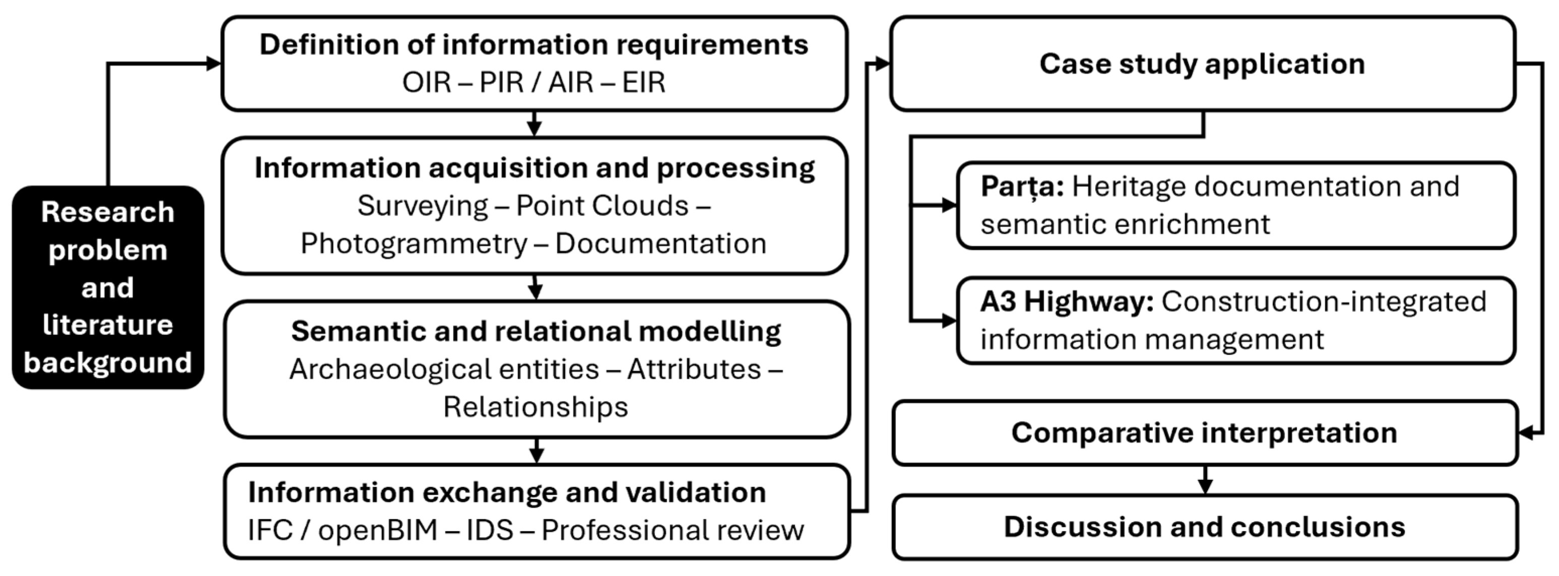
Figure 1 summarises the research methodology adopted in this study, linking the definition of information requirements with data acquisition, semantic and relational modelling, information exchange and validation, and the subsequent application of the framework to the two complementary case studies.
2.1. Standards, Framework, and Process
The BIM standards landscape plays a crucial role in ensuring the successful implementation of BIM in archaeological site management. Organisations like building SMART International [
13] and national standards bodies have developed frameworks and guidelines for BIM implementation, including data standards, information requirements, and interoperability standards. The standard landscape [
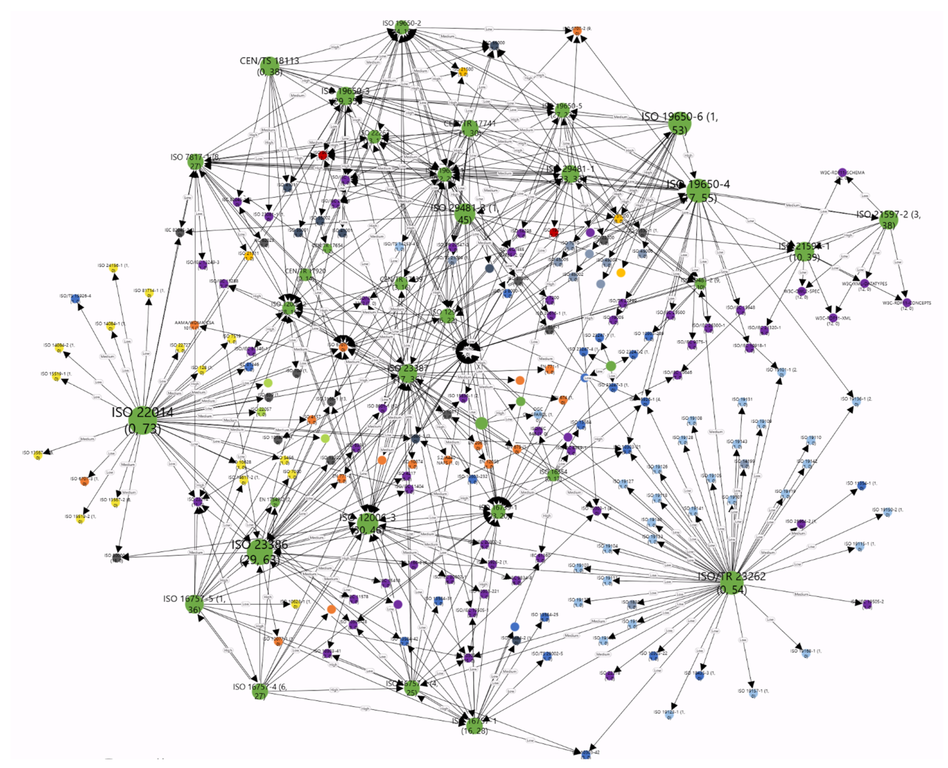
14] for BIM, schematically presented in
Figure 2, is a comprehensive structure that integrates 35 standards and 473 relations aiming to ensure consistency, collaboration, and efficiency in information management across the project lifecycle.
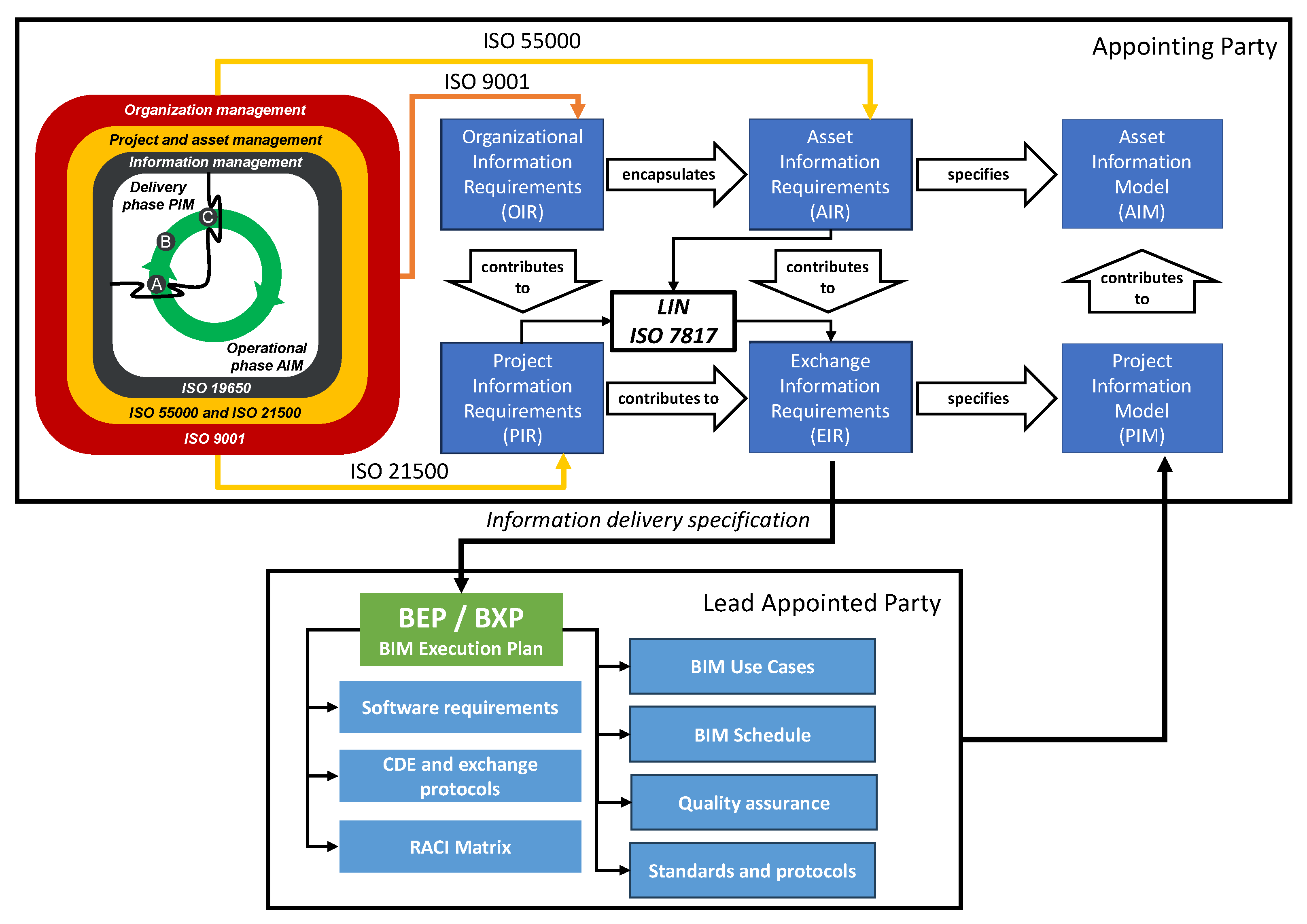
At its core, the framework is built upon ISO 19650 series, which establishes principles for managing information through the project information model (PIM) during the delivery phase and the asset information model (AIM) in the operational phase. This process is underpinned by robust quality management systems like ISO 9001 [
15] and integrates with asset and project management standards such as ISO 55000 [
16] and ISO 21500 [
17]. The framework begins with the definition of organisational requirements through the Organisational Information Requirements (OIR) and flows into the AIRs and PIRs, structured by ISO 19650, part 1 [
18]. In practice, the standards landscape extends as the Exchange Information Requirements (EIR) are developed and information delivery mechanisms are employed, standardised under ISO 29481 series [
19]. Detailed interaction is facilitated through process and interaction relationships maps, which govern business activities and data exchanges. Further, ISO 7817 [
20] provides a structured methodology for specifying the level of information need and defining consistent information delivery processes. It establishes principles and guidelines to determine the detail and extent of information required for effective data exchange throughout the lifecycle of built assets. Applicable across the entire lifecycle of built assets—from strategic planning and design to construction, operation, maintenance, and end-of-life—ISO 7817 ensures that information delivery aligns with the project’s evolving requirements.
The framework generally integrates the Model View Definition (MVD) [
21], a specific recipe for using IFC (formalised within ISO 16739 [
22]) for a particular purpose. While IFC allows for various levels of detail in building models, an MVD clarifies which information (like 3D geometry or construction details) is necessary for a specific use case, like coordination between different disciplines in a construction project. This helps ensure software tools using IFC can understand each other and exchange data effectively. Further standards like ISO 12006-2:2015 [
23] play a critical role in structuring this information by providing a framework for classifying construction-related information, while offering a standardised approach to organising data about construction works. In complement, ISO 12006-3:2022 [
24] introduces an object-oriented framework for information management, ensuring consistency and interoperability in the digital representation of construction elements and processes. This structured approach ensures seamless collaboration and decision-making among stakeholders, from the delivery phase to asset operation, enabling precise documentation, enhanced traceability, and the effective lifecycle management of construction and infrastructure projects.
Figure 3 presents schematically the minimal recommended standard landscape within a BIM-enabled project.
In general, the workflow begins with the definition/evaluation of OIRs, which define the information needed to support the organisation’s strategic objectives, statutory obligations, governance responsibilities, and high-level decisions. The OIRs provide the basis for two complementary requirement streams, i.e., PIRs that identify the information needed to manage and evaluate a specific project, and the AIRs that define the information required to operate, maintain, monitor, conserve, or otherwise manage the asset throughout its operational lifecycle. Relevant OIRs, PIRs, and AIRs are subsequently distilled into EIR, establishing the information to be delivered at each exchange milestone, including its purpose, content, Level of Information Need (LIN, as formalised by ISO 7817), delivery date, responsible party, format, and acceptance criteria. Although the figure presents the AIR and EIR as parallel elements, they are interconnected: project exchanges may be required to progressively produce the information needed for both project delivery and future asset management. In response to the EIR, prospective lead appointed parties develop the BIM Execution Plan (BEP/BxP), initially as a pre-appointment proposal and subsequently as an agreed post-appointment delivery plan. The BEP formalises how the project team will fulfil the information requirements explicitly required within the EIR. It defines the intended BIM use cases, software environment, information-production methods, Common Data Environment (CDE) and exchange protocols, delivery schedule, quality-assurance procedures, roles and responsibilities—commonly expressed through a RACI matrix—and applicable standards and protocols. The BEP consequently acts as the principal procedural link between the contractual requirements and their implementation by the delivery team.
During the delivery phase, the appointed parties produce, coordinate, review, authorise, and exchange information through the agreed CDE. The accepted information is progressively assembled within the PIM, which supports design, construction, coordination, archaeological investigation, or other project-specific activities. At defined decision points, the PIM is assessed against the EIR through automated checks and professional review. Information Delivery Specifications (IDS) may complement this process by translating selected human-readable requirements into machine-readable rules for validating IFC datasets. At project handover, the verified information needed for continuing asset management is selected from the PIM, supplemented where necessary, and transferred into or used to update the AIM. The AIM is therefore not simply the complete PIM renamed at handover; it is the validated and maintained information resource required to support the organisation’s AIR during operation. Operational experience, monitoring results, changes to the asset, and new organisational objectives may subsequently lead to updates of the AIM, AIR, or OIR, establishing a continuous feedback loop between organisational management, project delivery, and asset operation.
In addition to BIM specific standards, several complementary ISO enhance the effectiveness of the framework by addressing broader aspects of information quality, security, and risk management. ISO 8000 series [
25] focuses on data quality, ensuring that information within the BIM framework is accurate, consistent, and reliable throughout its lifecycle. High-quality data is critical for informed decision-making, effective collaboration, and successful project outcomes. ISO 27000 [
26], which addresses information security, provides guidelines to safeguard sensitive project data, ensuring confidentiality, integrity, and accessibility. This is particularly important in BIM environments, where numerous stakeholders exchange large volumes of data across digital platforms. Finally, ISO 31000 [
27] on risk management offers a systematic approach to identifying, assessing, and mitigating risks in the context of BIM processes. By integrating these standards, the BIM framework not only ensures technical efficiency and data interoperability but also upholds the principles of security, quality, and proactive risk management, creating a resilient and reliable digital construction environment.
Within the context of archaeological sites, as recommended Historic England Organization [
28], the first task when adopting a BIM information-management approach is to develop an AIM, an information model relating to the operational phase of the asset. To support this development, Historic England has also published a technical guidance [
29] that focuses on heritage asset management. Next, the BIM process shall continue with the identification of essential information needed to manage and maintain the archaeological site throughout its lifecycle (i.e., high-level requirements) outlined within the OIR [
30]. By understanding the specific needs of stakeholders, such as heritage managers, archaeologists and conservators, the OIR should enforce critical data collection related to site history, cultural significance, and conservation needs.
These requirements should be provided by the authority that is responsible for conservation and be used to create the following basis:
The AIR [
31] document provides a detailed framework for capturing, analysing, and preserving the unique characteristics of cultural heritage assets. The AIR outlines the specific data needed to comprehensively document archaeological sites and their components, ensuring long-term conservation. Key requirements include the creation of detailed 3D models of structures, artefacts, and stratigraphic layers, as well as the integration of material properties, spatial analysis, and contextual information about the site’s historical and cultural significance. To develop a robust AIR, it is essential to consider previous archaeological studies conducted in or near the site, the presence of nearby heritage assets listed in registers or identified through historical records, and the site’s cultural significance. Additional inputs should include assumptions about site boundaries, historical land use patterns, potential subsurface impacts, and relevant laws and regulations. The AIR should also identify necessary permits and licences, mitigation measures, and the involvement of key stakeholders, such as heritage authorities and local communities. By clearly defining these requirements, AIR ensures that heritage sites are documented and preserved with precision and care, aligning with conservation objectives.
The PIR document specifies the information necessary to effectively manage and execute cultural heritage projects. PIRs focus on the operational aspects of the project, such as defining data standards, selecting appropriate tools and technologies, and establishing workflows to streamline BIM processes. It also includes quality control procedures to ensure the accuracy, reliability, and completeness of data. To develop the PIR, project teams must consider the type of construction work being carried out (e.g., residential, commercial, or infrastructure), detailed plans and designs for the site, and a clear project timeline, including key milestones. Specific deliverables should address methodologies for archaeological evaluations, such as geophysical surveys, trial excavations, or desk-based studies, as well as strategies for mitigating unexpected discoveries. Plans for data management, including recording methods, data analysis, and long-term archiving, must also be included. The PIR should account for the allocation of resources, such as supplementary funds for investigations, and ensure the availability of qualified personnel and necessary equipment for fieldwork and analysis. By establishing these detailed requirements, the PIR ensures that project execution is efficient, collaborative, and aligned with the broader goals of heritage conservation.
The EIR [
32] document for cultural heritage projects serves as a critical framework for defining how information will be exchanged between stakeholders, ensuring that all data is accurate, timely, and interoperable. The EIR outlines the specific data deliverables required at various stages of the project, including file formats, data validation protocols, and delivery timelines, to support the preservation and management of archaeological sites. For cultural heritage cases, the EIR should mandate the use of standardised formats, such as IFC for geometric data and XML or JSON for metadata, to ensure seamless integration with BIM platforms and GIS systems. It should specify requirements for sharing comprehensive 3D models, stratigraphic layers, and contextual information about artefacts and structures. Key deliverables should include geospatial data in the coordinate reference system defined by the project EIR; in the Romanian case studies presented in this paper, this corresponds to the STEREO70 system. The EIR should also establish quality assurance procedures, such as automated checks for completeness and consistency, alongside manual reviews to confirm alignment with project objectives. To streamline collaboration, the document should define protocols for regular data exchanges between archaeologists, project managers, and construction teams, supported by cloud-based platforms for real-time updates. Clear milestones for information submission, such as the completion of each excavation phase, and detailed acceptance criteria for deliverables are essential to maintain transparency and accountability. Additionally, the EIR should address contingency plans, including strategies for unforeseen discoveries, and outline data archiving procedures to ensure long-term accessibility. By clearly defining these elements, the EIR enables efficient coordination, fosters interdisciplinary collaboration, and ensures the accurate preservation of cultural heritage throughout the project lifecycle.
The EIR should define required information structures and exchange formats independently of the native authoring software, allowing different BIM, GIS, survey, and heritage applications to participate in the same information workflow.
To ensure that the construction project is carried out responsibly and aligns with the archaeological heritage conservation requirements, collaboration with local and/or centra heritage authorities is paramount. The conservation strategy shall be discussed in detail to get the necessary permits and approvals, while making sure that all assets and relevant information in preserved. Additionally, adherence to ethical guidelines and best practices in archaeological research and conservation is critical, while public engagement should be considered as a vital component of responsible archaeological practice, especially when dealing with sites of significant heritage value. The considered strategy should answer the following questions (non-limiting):
What level of detail is typically required for geometric data in this context? Should we focus on high-resolution models or faster, lower-resolution scans for immediate decisions?
Which specific challenges have you observed when trying to preserve sites during construction? For example, stakeholder resistance, budget issues, or technical limitations.
Are there specific tools or workflows you want highlighted? For instance, drones for aerial scanning or specific software like Revit for BIM integration.
Should the discussion include how this data is presented to regulatory bodies or stakeholders? For example, using the models to comply with heritage preservation laws.
Do you want to emphasise public engagement or focus strictly on technical preservation and construction integration?
2.2. Technical and Technological Considerations
Structured data collection, especially when integrated within a BIM workflow, plays a pivotal role in the documentation, analysis, and preservation of archaeological sites, ensuring that the historical, cultural, and structural integrity of the site is maintained. It allows for precise recording of spatial, geometric, and contextual information, creating a holistic digital representation of the site, capturing critical details, from stratigraphy to artefact locations and ensuring that even the smallest features are documented for analysis and future reference. Accurately documented data further supports preserving fragile elements and mitigating risks associated with environmental changes, structural instability, or construction activities. Within a BIM-enabled framework, collected data can be used to monitor changes over time, assess the site’s structural health, and dynamically adapt conservation efforts, ensuring the site’s preservation for generations. This methodology ensures that cultural heritage is preserved in a way that aligns with all stakeholders’ requirements, fostering global respect for historical sites while advancing technological innovation in heritage conservation. Detailed 3D models can play a pivotal role in archaeology, enabling archaeologists to virtually analyse and reconstruct excavation layers, helping them to understand the temporal progression of human activity at a specific site. Furthermore, 3D models can aid the interpretation of complex archaeological contexts by providing an accurate and interactive visual representation, which can be revisited long after the excavation has ended. Such models can support long-term conservation efforts by preserving a detailed digital record of the site’s condition at the time of discovery, reducing the need for invasive documentation techniques. Additionally, 3D models can be used to enhance public education by creating engaging, accessible digital reconstructions that bring archaeological discoveries to life for non-specialist audiences, fostering broader appreciation for cultural heritage. Supporting the model development, modern 3D scanning technology provides extremely high levels of precision, crucial for capturing the intricate details of archaeological sites (i.e., fine artefacts, uneven surfaces, and complex stratigraphy). Depending on the scanning technique, the distance to the subject and accuracy and precision requirements, the resolution of the point cloud can range from sub-millimetre to several centimetres.
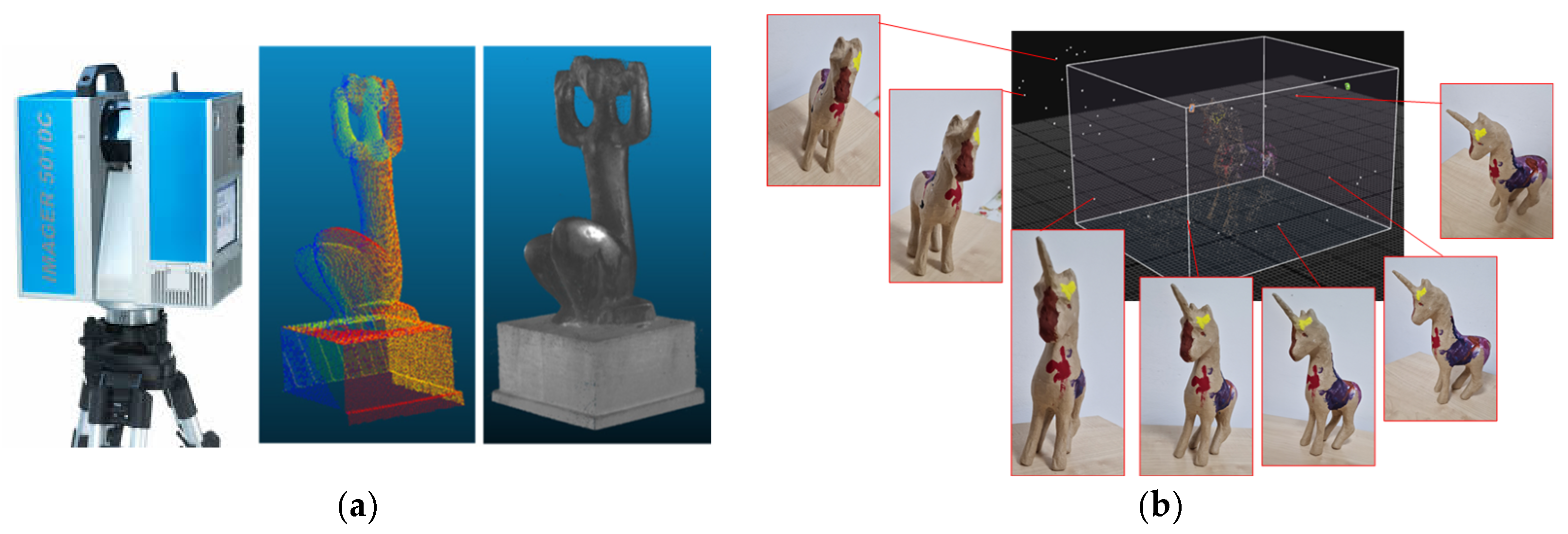
Out of the many available options, Laser Scanning (LS) and Photogrammetry are the most prominent. LS (presented in
Figure 4a) is a ground-based method ideal for capturing detailed spatial data of large-scale excavation sites. It uses high-precision laser pulses to generate dense point clouds that represent the geometry of the site with sub-millimetre accuracy.
Photogrammetry technology is particularly effective for mapping complex archaeological contexts, such as stratigraphic layers, standing structures, or open excavation pits. Its ability to capture large areas quickly ensures minimal disruption to ongoing construction activities, making it a preferred choice for time-sensitive projects. Photogrammetry (presented in
Figure 4b) combines high-resolution photography with specialised software to create detailed 3D models. By analysing overlapping images taken from multiple angles, photogrammetry reconstructs the geometry of archaeological features. This technique is cost-effective and accessible, making it a popular choice for projects with limited resources. Photogrammetry excels in capturing intricate details of artefacts, fragile structures, or excavation trenches, offering a visually rich, interactive digital representation that complements laser scanning.
Each of these technologies offers unique advantages, enabling archaeologists to tailor their approach to the specific challenges and requirements of the site. Combining these methods often yields the most comprehensive and accurate results, especially in high-stakes preservation scenarios.
2.3. From 3D Point Cloud to a BIM Model
One of the principal challenges in the digital preservation of archaeological sites is representing their socio-cultural and economic histories alongside their physical characteristics. Integrating such contextual information into BIM serves three interconnected purposes: (i) contextualising archaeological findings, (ii) supporting their interpretation, and (iii) strengthening public engagement.
First, socio-cultural and economic information provides the context necessary to understand the significance of the artefacts, structures, and features identified during archaeological investigation. By linking modelled entities to historical records and structured metadata—such as chronology, site function, social organisation, production activities, and trade relations—a BIM model can represent both the physical composition of a site and its historical and cultural significance. Importantly, this information should not be stored only as general model-level metadata. It should be associated with the relevant entities and with the spatial, stratigraphic, chronological, and functional relationships among them.
Second, embedding contextual information can transform the BIM model from a geometric representation into a platform for developing, documenting, and evaluating archaeological interpretations. Physical evidence can be connected to interpretative narratives concerning interactions among cultural groups, changes in economic activity, successive phases of occupation, or the role of the site in broader historical events. This relational structure provides a more comprehensive representation of the site by explaining how its built environment was shaped by—and, in turn, influenced—the communities that inhabited and used it.
Third, the contextual enrichment of the model can support public outreach, education, and community participation. Virtual tours, educational applications, and digital exhibitions can use the model to communicate the historical significance of the site in an accessible and engaging manner. Users can therefore explore not only the site’s physical appearance but also how its inhabitants lived, worked, traded, and interacted with their environment. By making these relationships more visible and understandable, BIM-based interpretation can help local communities recognise their connection to the site and participate more actively in its preservation.
The development of information-rich model usually begins with accurate digital documentation of the site. By combining three-dimensional surveying with structured information modelling, archaeological sites can be recorded at a high enough level of geometric detail and subsequently enriched with information required for investigation, interpretation, and conservation [
33]. Depending on the characteristics of the site and the project requirements, data may be acquired using laser scanning, photogrammetry, total-station surveying, or a combination of these techniques. The next stage is to convert or interpret the captured data as a usable three-dimensional representation. Meshes are particularly suitable for irregular geometries, such as deteriorated walls, carved surfaces, terrain, and artefacts, whereas parametric or solid objects may be more appropriate for components with clearly identifiable geometry. The choice of representation should consequently reflect the scale of the surveyed element, its geometric complexity, the intended analyses, and the required level of detail. The resulting meshes and reconstructed objects can then be imported into or created within a BIM platform [
34].
Importing geometric data does not produce an archaeological BIM model. The elements must be classified, structured, and enriched according to clearly defined project and conservation information requirements. In this context, “smart objects” [
35] should represent identifiable archaeological entities (e.g., structures, construction components, artefacts, stratigraphic units, deposits, cuts, and reconstructed features) and contain relevant attributes concerning their materials, chronology, provenance, condition, function, documentary sources, and degree of interpretative certainty [
36].
Equally importantly, the model should represent relationships between identified entities rather than treating them as independent objects. Such relationships may describe containment, adjacency, physical connection, stratigraphic succession, functional association, provenance, construction phase, or evidential dependency. For example, an artefact should be connected to its context of discovery; a wall should be related to the stratigraphic units it intersects; and reconstructed elements should be linked to the evidence and assumptions supporting their interpretation. Through this relational approach, the BIM model becomes a structured archaeological knowledge environment rather than merely a collection of geometrically modelled components.
To facilitate open and platform-independent information exchange, the IFC data model is recommended as the principal exchange structure. IFC provides a transparent and standardised basis for representing objects, attributes, spatial containment, and selected relationships. It is worth noting that the standard entities and relationships within the IFC standard were primarily developed for contemporary built assets and do not fully represent archaeological concepts such as stratigraphy, provenance, interpretative uncertainty, or successive historical phases. Rather than relying exclusively on existing IFC structure, archaeological entities should be mapped to the most appropriate IFCs and supplemented with project-specific property sets, classifications, document associations, relationship entities, and external semantic resources. Where IFC cannot adequately express domain-specific meaning, it may be linked to archaeological ontologies or controlled vocabularies. This combined approach preserves openBIM interoperability while enabling the model to represent the particular informational and relational complexity of archaeological sites. Selected mandatory alphanumeric information can subsequently be translated into IDS requirements for automated verification.
3. Case Studies
The two case studies presented in this section are used as complementary applications of the proposed requirements-driven framework rather than as controlled comparative experiments. The Parța Neolithic Sanctuary illustrates the use of reality-based geometry and structured archaeological information for documentation and conservation, while the A3 highway case examines archaeological information management within an active infrastructure project. Quantitative indicators are reported where they were available in the original project documentation; where acquisition or performance metrics were not recorded, these limitation are explicitly acknowledged.
The protection and management of cultural heritage and archaeological sites in Romania are governed by a comprehensive legal framework designed to safeguard historical monuments and archaeological assets while facilitating their integration into modern development projects. Key legislation includes Law No. 422/2001 [
37] on the protection of historical monuments, which establishes the criteria for identifying, classifying, and preserving monuments of national and local importance, Governmental Ordinance 43 from 30 January 2000 [
38] (enforced by Law 378 from 10 July 2001 [
39] and completed by Law No. 462/2003 [
40]), which focuses on archaeological heritage and designates areas of national interest. Complementing these are laws regulating movable cultural assets, environmental considerations, and data protection, such as Law No. 182/2000 [
41]. Additionally, several professional standards ensure systematic archaeological investigations and robust information-management practices. This legal and technical context ensure a robust framework that emphasises transparency, traceability, and the ethical stewardship of cultural assets.
A step-by-step framework for initiating investigations is summarised below:
Preparation of the application for authorization that is submitted to the Ministry of Culture (or its delegated County Directorate for Culture) to obtain the intrusive archaeological diagnosis authorization. The application must include the following documents:
A research proposal that outlines the investigation objectives, methodologies, and anticipated outcomes.
Evidence of collaboration (e.g., a signed contract between the construction entity and a certified archaeological organisation).
Supporting documentation (e.g., site plans, project descriptions, and prior studies), ensuring compliance with local and national heritage protection laws.
Drafting the Archaeological Research Project charter, a central document to the authorization process. This defines:
Research objectives, specifying the scope of the investigation.
Methodologies (i.e., stratigraphic analysis, photogrammetry, or laser scanning) employed for ensuring alignment with both legal and technical rigour.
Data management protocols, encompassing standards for the collection, storage, and transfer of archaeological findings.
Obtaining Notices and Approvals, including the following:
The notice from the County Directorate for Culture’s to confirm compliance with conservation norms.
Specific approvals for data handling, ensuring traceability and secure storage of both physical artefacts and digital data. Coordination with various agencies highlights the importance of standardised formats for data transfer and storage, a challenge often compounded by disparate requirements among stakeholders.
Within this rather straight forward process, a series of key information-management challenges arise:
Diverse data types as archaeological investigations produce a wide range of data (e.g., stratigraphic records, 3D models, historical metadata and expert documentation) often stored in inconsistent formats.
Traceability issues emerged related to data flows between field teams, cultural authorities, and construction stakeholders.
Coordination gaps as various entities often have conflicting data storage solution and information use requirements.
To address these challenges and build upon Romania’s robust legal framework, BIM emerges as a powerful tool for integrating cultural heritage preservation with sustainable development. By embedding legal compliance into BIM workflows, professionals can develop structured, information-rich models that seamlessly incorporate research findings, site plans, and regulatory documentation. BIM provides significant advantages, including the following:
Transparency is achieved by visually linking authorization steps and compliance milestones to 3D site models.
Traceability is achieved by documenting the history and progression of approvals, ensuring accountability at every stage.
Protection of Cultural Assets is performed through virtual simulations that predict the impact of construction activities on archaeological sites, allowing for data driven conservation strategies.
3.1. The Parța Neolithic Sanctuary [42]
The Neolithic sanctuary of Parța is part of a significant archaeological site in Romania and offers a compelling use case for the application of BIM in archaeological site management [
43]. Discovered in the 1970s, this site has revealed fascinating insights into the spiritual beliefs and practices of early Neolithic communities. The sanctuary, characterised by its unique circular enclosure and central altar, is believed to have served as a focal point for ritual activities, including offerings and communal gatherings. The research carried out at Parţa has led to the defining of the Banat culture and its groups: Bucovăţ and Mateiski Brod, groups from western Banat that appear under different names, but which were insufficiently defined and which are closely related to Parţa and the Banat culture [
43,
44,
45,
46,
47]. Within the present study, the Parța case is used primarly to illustrate the transition from reality-based geometric documentation to a structured archaeological information model. The available digital representation combines point-cloud-derived geometry with contextual, historical, and object-level information that can be associated with identifiable archaeological entities. The case serves as a proof-of-concept for semantic enrichment rather than as a complete digital inventory of all archaeological finds documented at the site.
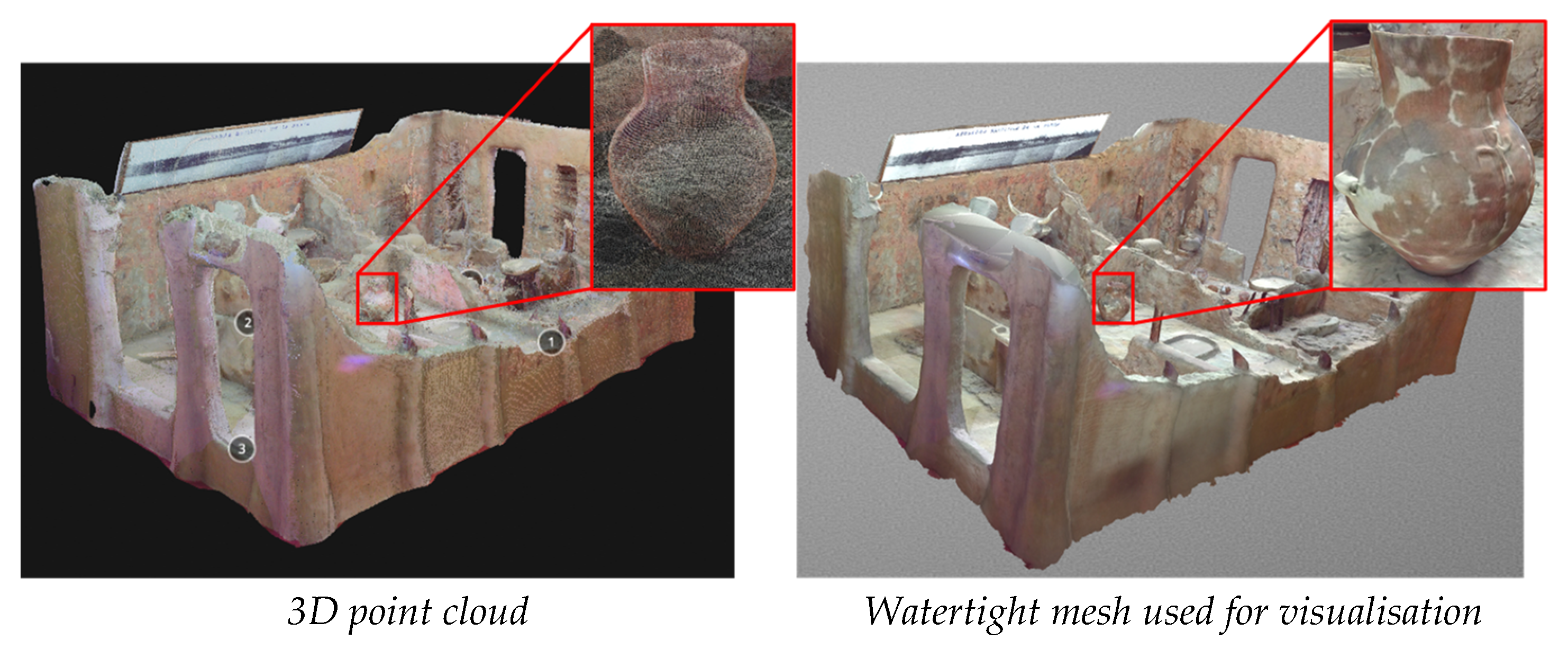
Figure 5 presents the initial 3D point cloud of the scaled reconstruction of the Parța Sanctuary together with the final ‘
water-tight mesh’ ready for visualisation.
In addition to geometric data, the following metadata can be easily integrated at model level:
Site location: 45°37′25″ N, 21°06′50″ E, on the right banks of Timis River.
Archeological metadata:
- ○
“The ceramic distribution is: fine ceramics 60%; 14% semi-fine; 26% usual. The gray species predominates, approx. 60%, of which 30% is fine.”
- ○
“The culture layers reach 2.10 m, and with the pit houses they exceed 2.70 m. Five levels of the Banat culture were researched…”
- ○
“The orientation according to the solstice is almost identical at Sanctuary 1 with that of Sanctuary 2, in fact a temple, as shown by the monumental statue, with numerous interior altars.”
- ○
In the vicinity was discovered a large flint blade and approx. 650 objects; pottery (including 120 fragments of cup legs); a microlithic flint object; two stone objects (grinder and crusher); three fragmentation bone tools (fishing hook, spatula, bone spear); a slingshot ball, a weight for the fishing net and 74 faunal debris, 1 hoof of a small animal, 1 dog mandible, 1 domestic pig jaw, 1 sheep mandible and others.
Socio-cultural information:
- ○
“It is considered that Sanctuary 2 was active between 5300-5100 BC”
- ○
“Community or household shrines are important because they bring many details related to archeoastronomy, not only their orientation, but also due to inventory items with signs and symbols related to stars, constellation”;
- ○
“Sanctuary 2 was large, having inside a monumental statue (over 1.70 m high), with five altars inside and two altars outside, for offerings and burning offerings, one in front of the eastern opening of the sanctuary and another towards south. The altars were meant for offerings for various deities with astral symbols.”
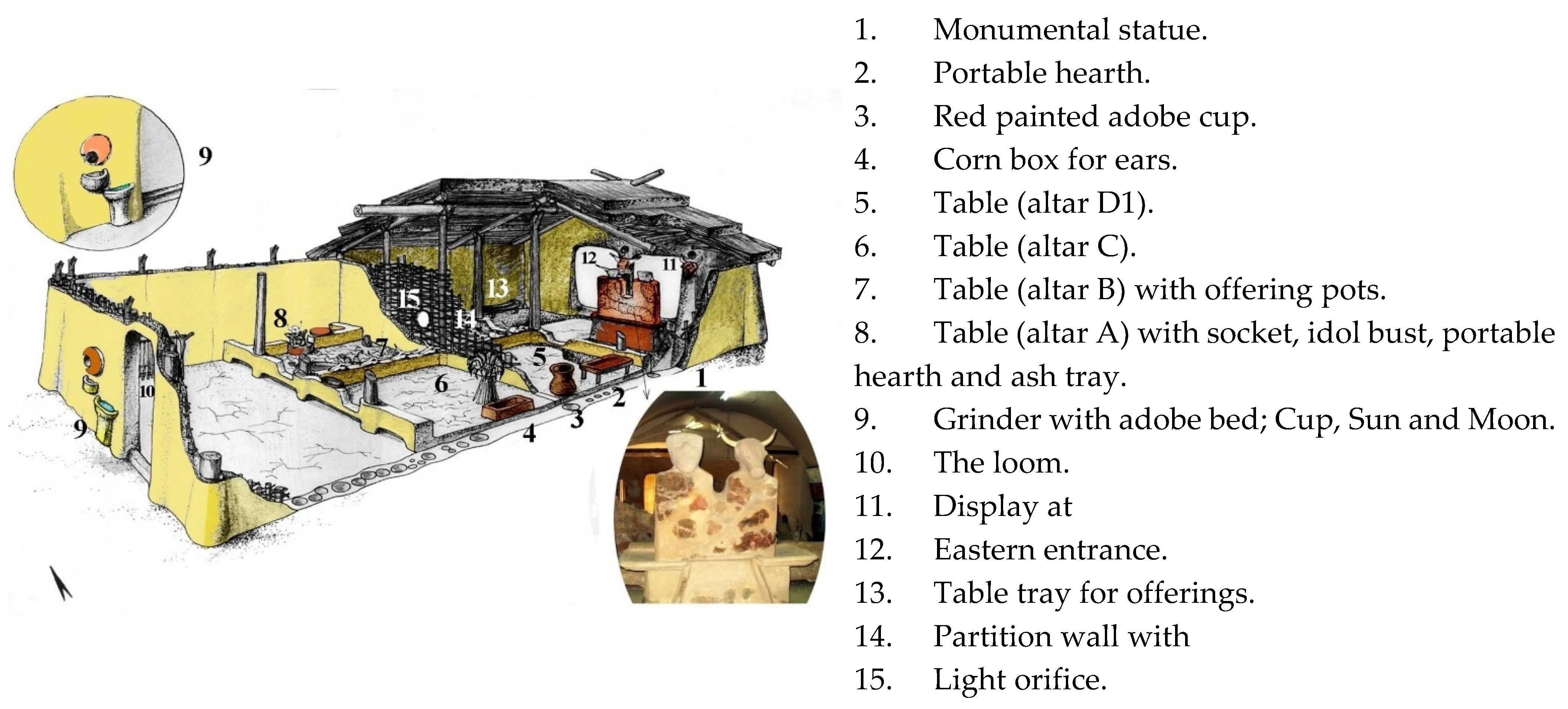
The data illustrates the distinction between model-level descriptive information and object-level archaeological information. While general site metadata provide historical and contextual background, information associated with identifiable arThe alphanumeric information associated with specific elements/sites can be further enriched with pictures and graphic representations and historic visions to further support site conservation, as showed in
Figure 6.
An element present in
Figure 6 could present the following information mapped on the IFC structure:
Next,
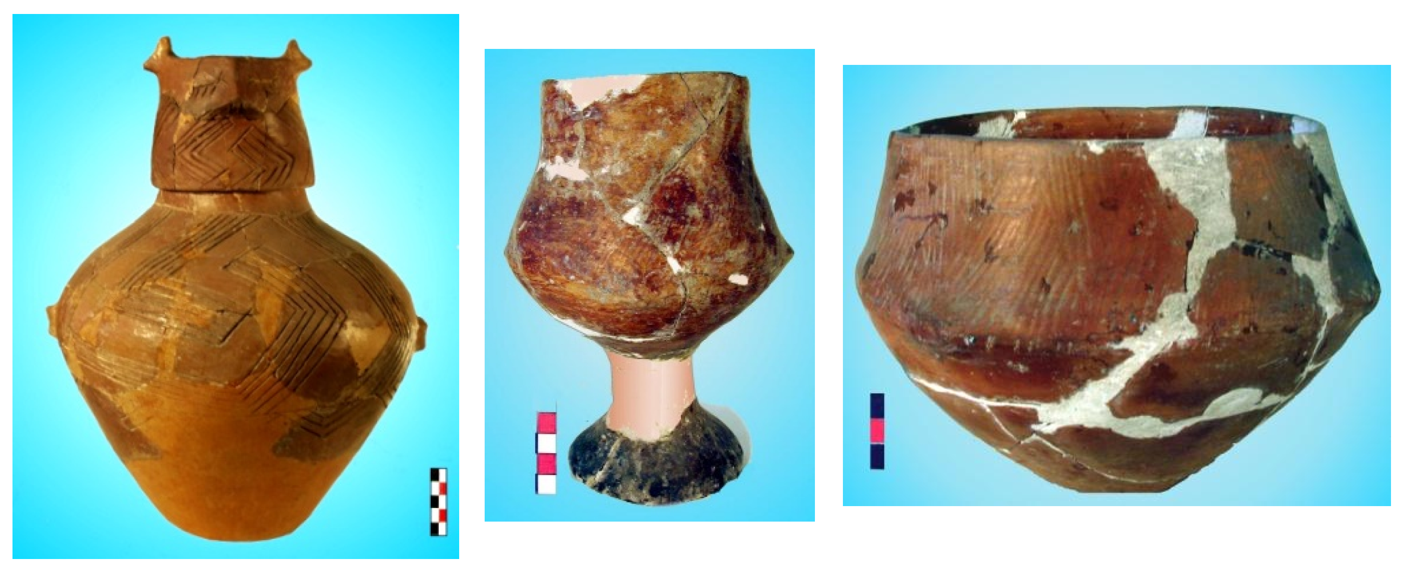
Figure 7 presents a series images captured on-site to document the clay objects evolution that can be easily attached to individual objects.
At object level, further information can enhance understating:
“…a pedestal for the bust idol no. 2 was installed, and in its vicinity was installed a portable hearth on which various products were burned (fats, meat, cereals).”
“…on altar B there were several vessels, probably with offerings, and a vessel with a human face with phalanges in it, certainly from meat offerings.”
“…on altar D there was a clay cup with much chaff in the composition, for blood offerings and a large portable hearth for depositing or burning offerings.”
“…on the altar table E there was just a large tray, probably for fruits.”
“Large clay balls (so as not to touch the objects of worship) were used to destroy the altar and the objects.”
“The evolution observed in ceramic materials, confirms the geographical position of the Parța group between Vinča and LBK and is confirmed by the black colors of-gray ceramics with linear incisions, with a new stylistics of the decorations”
“… assets, evolve towards the Szakálhát culture with their own characteristics, shapes and vinčiene decorations, also with local specificity”.
To further support conservation, each artefact can be encoded with a unique GUID (Globally Unique Identifier) that can be registered at national or even international level, allowing for easy identification and classification. The approximately 650 objects referred to in the archaeological documentation represent recorded archaeological finds and should not be interpreted as 650 individually modelled BIM entities. In the present case study, GUID assignment is proposed as an information-management mechanism for identifiable modelled objects rather than reported as having been implemented for the complete archaeological inventory.
Detailed model-complexity metrics, such as the number of BIM entities, point-cloud density, or mesh polygon count, were not recorded in the original project documentation and are therefore not retrospectively estimated.
3.2. Archeologic Sites on A3 Highway, Romania
The second case study concerns the preventive archaeological investigations undertaken as part of the project entitled Connection Road between the Calea Sântandrei Roundabout and the A3 Biharia Highway. The proposed road extends for approximately 19.7 km and crosses an area characterised by archaeological remains from several historical periods. Unlike the Parța case study, which concerns the documentation and management of a recognised archaeological site, this case illustrates the information-management challenges arising when multiple archaeological areas are identified along the linear corridor of an active infrastructure project. In such projects, archaeological investigations must be closely coordinated with the construction programme because the discovery, documentation, assessment, and protection of archaeological remains may directly affect when individual sections of the site can be released for construction. The A3 case is therefore used to examine how the proposed information-management framework can connect archaeological documentation, spatial referencing, statutory milestones, and construction-related decisions within a linear infrastructure context.
The investigations were conducted under Contract No. 470 of 14 October 2021, concluded between S.C. STRABAG S.R.L., acting as the main contractor, and the Țării Crișurilor Museum in Oradea, acting as the authorised archaeological organisation. Intrusive archaeological diagnosis identified nine areas of archaeological interest at different chainages along the proposed road. The sites include remains attributed to the Neolithic, Bronze Age, Roman-period Barbaricum, medieval period, and a more recent burial context. Some locations contain evidence from a single period, whereas others are multi-layered sites preserving archaeological remains from several successive phases of occupation. The location, approximate extent, and preliminary chronological classification of the nine investigation areas are summarised in
Table 1.
The linear character of the project creates a particularly demanding information environment. Each archaeological site must be documented as an individual spatial and interpretative context while remaining connected to the overall road alignment, construction sectors, land boundaries, protection areas, and project programme. The resulting information includes excavation limits, trenches and sections, contour and survey points, stratigraphic profiles, archaeological features, artefact inventories, photographs, drawings, specialist observations, regulatory documents, and construction-clearance decisions. These datasets are produced by different stakeholders, at different stages, and in several formats. Their effective management therefore requires reliable identifiers, consistent georeferencing, explicit links between artefacts and their discovery contexts, and traceability between field evidence, archaeological interpretations, statutory approvals, and subsequent construction decisions.
All areas designated for Permanent Works that intersect with the nine archaeological sites defined before must undergo comprehensive “preventive archaeological research.” Only after these investigations are completed and the archaeological heritage within these areas is thoroughly documented and assessed can the land be cleared for construction activities related to the investment project. For each of the nine archaeological sites identified through intrusive archaeological diagnostics, the legally authorised state authorities must issue the so called “Certificates of Discharge from Archaeological Burden” (translated from Romanian). These certificates, approved by the National Archaeology Commission, officially remove the protective status imposed on the affected land. Until these certificates are granted, no construction work can commence on the respective sites, ensuring that all cultural and historical values are fully preserved and integrated into the project’s documentation. This requirement underscores the critical importance of thorough archaeological research incorporated in construction workflows, emphasising that no development can proceed until all heritage elements are appropriately recorded, analysed, and safeguarded. According to national law, before starting the investigations, several documents must be prepared and all notices and authorizations must be obtained.
In the current Romanian statutory procedure, the BIM model does not replace the legally required archaeological documentation and is not connected to an automated governmental approval interface. Within the proposed framework, BIM and GIS support the organisation, coordination, and traceability of the information used to prepare the statutory submission. Reports, plans, inventories, coordinate records, and other required documents remain subject to formal review by the competent authority, while model-based and IDS-supported checks can be used internally to verify completeness and consistency before submission.
For this project, these were as follows:
Application for authorization (no. 601/02.12.2021) to request the issuance of intrusive archaeological diagnosis authorization.
Collaboration contract between S.C. STRABAG S.R.L. and the Țării Crișurilor Museum-Oradea.
Archaeological research project that is to be attached to the application for authorization. The document defines the research objectives and methodology.
Notices and approvals like the notice of the County Directorate for Culture and other competent authorities to ensure compliance with the archaeological heritage protection norms.
Within the next step, the main objectives for the archaeological research were defined, as follows:
Identification of archaeological sites along the axis of the road, including their stratigraphy and cultural contexts.
Delimitation and registration of all sites, with a strong focus on ‘protection area’ to ensure conservation.
Protection of archaeological heritage by establishing protection measures for all sites identified along the route.
Development of a comprehensive information repository to support future monitoring, conservation, and research activities.
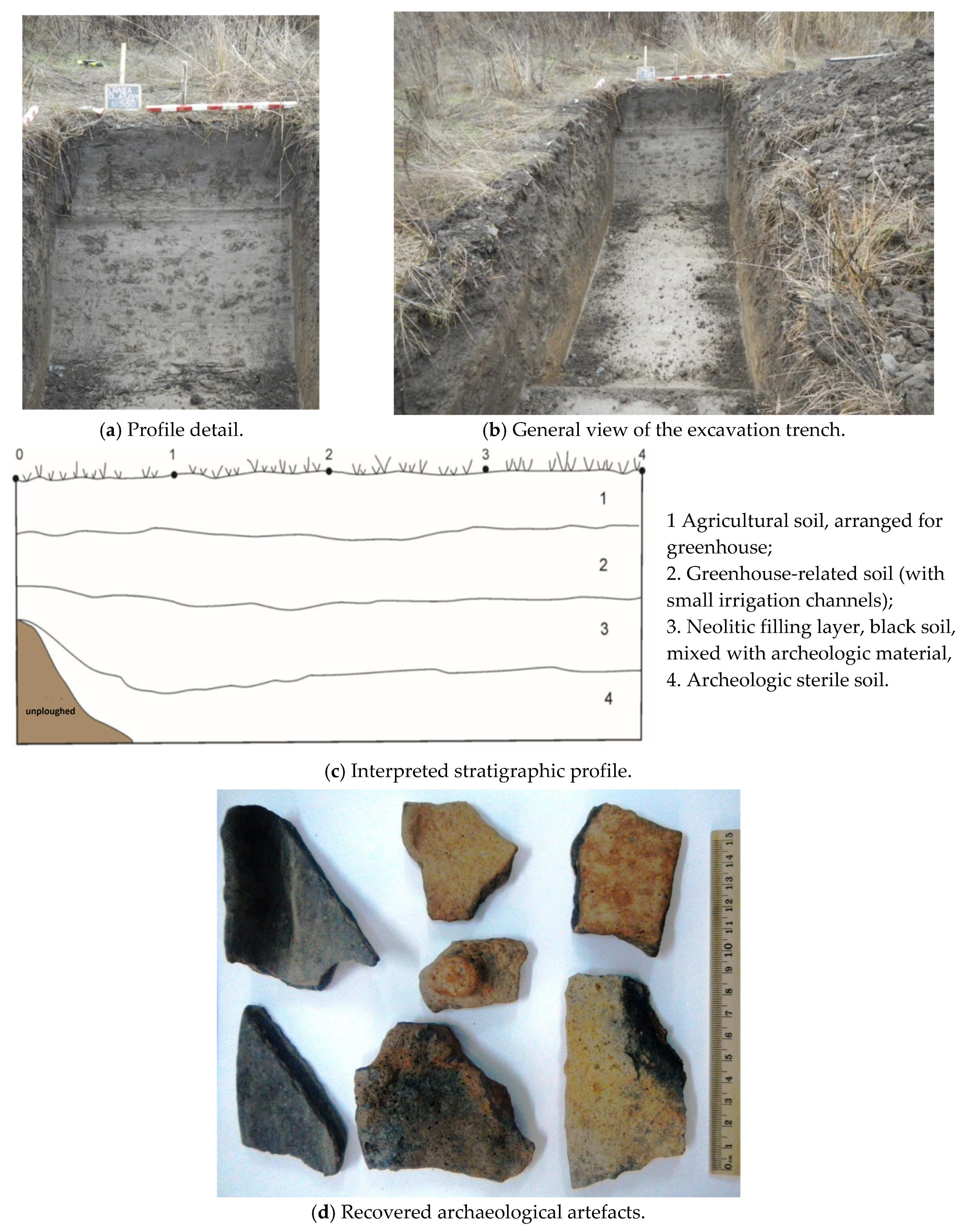
Figure 8 illustrates an example of archaeological documentation undertaken in Section 50. It combines photographic records of the excavated trench, a stratigraphic profile identifying the principal soil layers, and a selection of recovered archaeological materials.
The archaeological investigations were conducted to ensure precise documentation and preservation of the findings:
Section layout and mapping: A total of 179 sections were laid out along the project’s route, with dimensions varying between 4 × 1.70 m and 10 × 1.70 m, totalling approximative 1870 m3 of excavated ground. Each section was carefully described and mapped using the STEREO 70 topographical system. This ensured accurate geospatial referencing of the sections, facilitating integration into digital mapping systems and supporting subsequent analysis within a BIM framework.
Archaeological excavations were conducted using both manual and mechanical methods, depending on the stratigraphic conditions of the site. The manual digging allowed for the careful extraction of delicate artefacts and stratigraphic layers, while mechanical excavation was employed in areas with stable or homogenous stratigraphy to expedite the process without compromising data integrity.
We performed the stratigraphic documentation of each section, including detailed information related to the cultural layers, sterile soils, and archaeological features such as pits, walls, or other complex structures. This step ensured that the vertical and horizontal relationships of the layers were preserved for accurate interpretation of the site’s historical context.
We also performed the collection, cataloguing and documentation of all artefacts uncovered during the excavations (e.g., ceramic fragments, bones, metal objects, and other items). Each artifact was assigned a unique identifier (i.e., GUID) and detailed information (i.e., metainformation) about its provenance, condition, and context was recorded to facilitate thorough post-excavation analysis and integration into digital archives.
Photographic and topographical documentation for all sections and studied sites. Each section was systematically photographed, capturing detailed images of stratigraphy, features, and artefacts in situ. Additionally, topographical surveys ensured that the spatial data of each site was accurately captured, allowing for precise visualisation and integration into GIS and BIM platforms for future conservation and monitoring.
The site survey identified a series of contour points georeferenced within the Romanian STEREO 70 coordinate system (EPSG:3844), with Northing and Easting values expressed in metres. An excerpt of their corresponding coordinates and elevations is provided
Table 2.
To improve the integration of archaeological information into construction projects, BIM can provide a structured framework for specifying, producing, exchanging, and verifying information. In addition to the definition of information requirements at multiple levels to ensure alignment between archaeological objectives, project goals, and construction activities, an Information Delivery Specification (IDS) can be developed. The IDS translates selected information requirements into explicit and verifiable rules, supporting consistent delivery and automated validation of archaeological data within BIM workflows. It should define the following:
Data formats used to coordinate data provided in both STEREO70-compatible formats and interoperable formats such as CSV or XML for easy integration into GIS and BIM platforms and stratigraphic layers and artefact documentation delivered in IFC-compliant formats for seamless BIM integration.
Content requirements for geometric data (e.g., high-resolution images, drawn sections, and 3D models representing excavation layers and artefact locations), metadata (e.g., provenance, material properties, cultural significance, and context of findings) and tabular data for detailed inventory of contour points (as presented in
Table 2), with corresponding descriptive attributes.
Verification and acceptance procedures to be used with automated validation tools within BIM platforms to check for completeness, consistency, and format compliance of delivered data.
For example, an EIR requirement stating that “all stratigraphic units shall contain a dating attribute” can be translated into an IDS rule applied to the corresponding IFC objects. The same principle can be used for mandatory provenance, classification, unique identifiers, or documentary references.
Review checkpoints can also be detailed to ensure that all required data fields are populated and align with the agreed standards.
Taken together, the two case studies illustrate complementary applications of the proposed framework. Parța demonstrates how reality-based geometry can be progressively enriched with archaeological and contextual information for documentation and conservation, while the A3 case demonstrates how distributed archaeological information can be structured and coordinated within an active infrastructure project. The cases therefore support the applicability of the requirements-driven approach under different information-management conditions, while also highlighting the need for future controlled validation of information completeness, retrieval efficiency, traceability, and review performance.
4. Recommendations for BIM Use in Archeologic Sites Conservation
Implementing a BIM framework for archaeological site conservation offers transformative potential but requires a structured approach to address its inherent challenges and opportunities. Effective integration depends on meticulously defining information requirements at various levels to align conservation goals with project demands. Key to this process are the information requirements, developed at different levels (i.e., OIR, AIR, PIR), which collectively ensure compliance with legal frameworks, the precise documentation of archaeological findings, and efficient project execution.
The recommendations presented in this section distinguish between the generic information-management principles of the proposed framework and the project-specific parameters required for implementation. While the requirements chain, entity-and-relationship modelling, open information exchange, and validation logic are intended to remain transferable between projects, elements such as coordinate reference systems, statutory procedures, software environments, and detailed deliverables must be configured according to the project and jurisdiction.
Table 3 provides a comprehensive overview of sample requirements for each category, illustrating how these frameworks support archaeological data management and site preservation. These requirements cover everything from compliance with cultural heritage laws to detailed 3D models, metadata for artefacts, and methodologies for excavation and data exchange.
Complementing contractual/human-readable information requirements established through OIRs, AIRs, PIRs, and EIRs, the Information Delivery Specification (IDS) translates selected requirements into explicit, machine-readable rules. It formalises the requirements that can be automatically verified within an IFC dataset. It can define the applicable objects and their required entities, classifications, attributes, properties, materials, values, units, and relationships. This enables software-based checking of whether the delivered model contains the required alphanumeric information and whether that information complies with the specified values and data structures. IDS therefore complements, rather than replaces, the contractual requirements by providing a consistent connection between requirements definition, information production, and automated validation.
For example, a human-readable EIR requirement stating that “all stratigraphic units shall contain a dating attribute” can be translated into an IDS rule applied to the IFC entities used to represent those units. The rule can check whether the required archaeological property set exists and whether the Dating property is populated. Similar rules can be defined for provenance, unique identifiers, classification, interpretation confidence, or documentary references.
</> XML
<ids:property dataType=“IFCLABEL” cardinality=“required”>
<ids:propertySet>
<ids:simpleValue>Archaeology_StratigraphicUnit</ids:simpleValue>
</ids:propertySet>
<ids:baseName>
<ids:simpleValue>Dating</ids:simpleValue>
</ids:baseName>
</ids:property>
IDS 1.0 is based on an XML Schema and is used to verify structured information in IFC datasets; it should not be confused with mvdXML and does not replace geometric model checking.
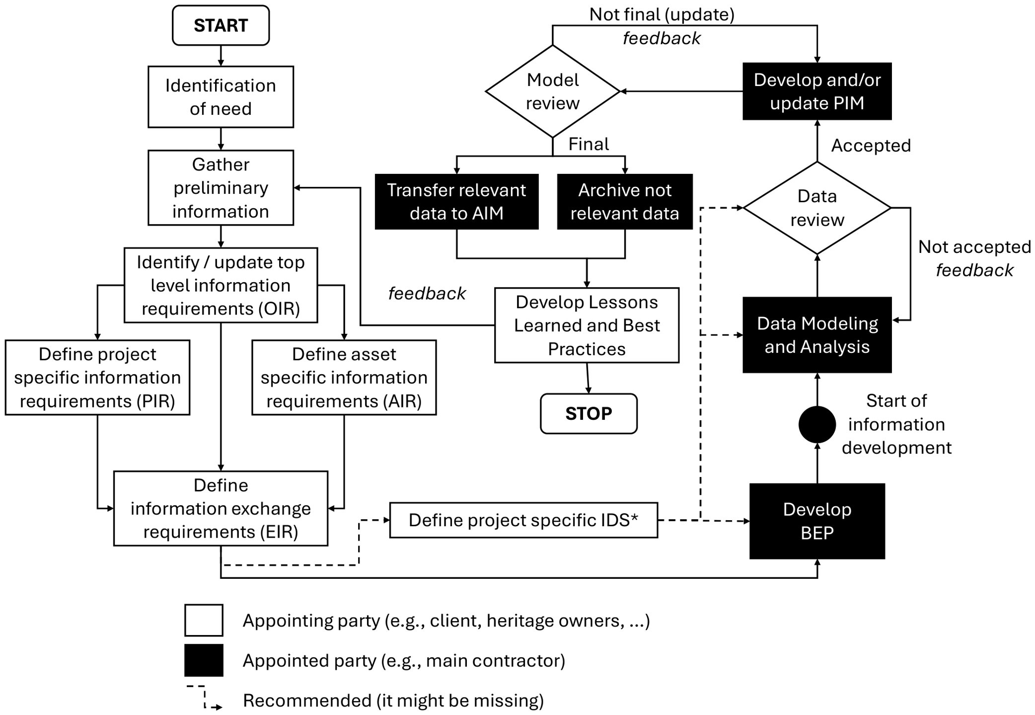
4.1. A Generic BIM Process for Conservation of Archeologic Sites
To successfully use the BIM framework for heritage conservation, a clear, actionable workflow is essential.
Figure 9 presents a requirements-driven information-management workflow that connects organisational objectives with the production, verification, exchange, and long-term preservation of project and asset information.
The proposed workflow (an adaptation of the generic BIM workflow presented in
Figure 3) begins with identifying the organisational, archaeological, conservation, and construction needs associated with the intervention, followed by collecting and assessing existing information, including archival records, previous investigations, survey data, planning documents, and available BIM and GIS datasets. The identified objectives and information gaps inform the definition or revision of the OIR, establishing the high-level information needed for heritage protection, regulatory compliance, research, public engagement, and long-term conservation. These high-level requirements are subsequently translated into PIR, addressing the scope, programme, responsibilities, risks, decision points, and expected outcomes of the archaeological investigation, and AIRs, specifying the information required for the continuing conservation, interpretation, monitoring, and management of the archaeological site or retained assets. Next, the EIR defines what information must be delivered, by whom, when, in which formats, and according to which acceptance criteria, including requirements for geometry, attributes, documentation, georeferencing, Level of Information Need, and the spatial, stratigraphic, chronological, functional, and evidential relationships among archaeological entities. Selected machine-verifiable provisions are translated into a project-specific IDS, while the BEP describes how the prospecting Lead Appointed Parties aim to meet the contractual requirements through agreed responsibilities, methods, software, Common Data Environment procedures, and quality-control processes.
The distinguishing feature of the proposed workflow is that information requirements precede model production. Geometry acquisition, semantic enrichment, exchange, and validation are therefore driven by previously defined information purposes and acceptance criteria rather than being determined only after the digital model has been created. This shifts the workflow from a model-first approach towards a requirements-driven information-management process.
Surveyed and documentary information is subsequently processed, georeferenced, classified, enriched, and integrated into a coordinated PIM, maintaining traceability between physical evidence, documentary sources, interpretations, and modelled entities. The resulting information is subjected to automated data validation, including IDS-based checks, and to expert model review to confirm its completeness, technical compliance, geometric reliability, archaeological meaning, and suitability for its intended purposes. Once accepted, information required for long-term conservation and management is transferred from the PIM to the asset information model (AIM), while other records possessing legal, scientific, evidential, or historical value are preserved within the project archive. Finally, lessons learned from requirements definition, information production, validation, coordination, and exchange are documented and used to improve future workflows, templates, and reusable IDS rules.
Throughout this process, collaboration among the appointing party, archaeological and heritage authorities, project managers, archaeologists, conservators, surveyors, designers, contractors, and BIM, GIS, and information-management specialists ensures that archaeological information remains reliable, traceable, interoperable, and usable throughout both the construction project and the subsequent management of the site.
4.2. The Flexibility of Strategically Planned BIM Framework
In their paper, Penjor et al. [
3], investigated the pivotal role of BIM in conservation of cultural heritage buildings, advocating for a collaborative approach to leverage BIM to foster interdisciplinary partnerships between architects, historians, and conservationists, for sustainable preservation of cultural heritage. As we progress from requirements to collaborative production of information within the project, we start using more and more technology to support our work. BIM authoring tools like Revit [
49], ArchiCAD [
50], Bonsai [
51] or other are used to create, manage, and document the models. To fully realise the BIM interoperability promise, open collaboration formats should be employed and, in the centre of it is the IFC. A single IFC file approach may work for small, simple projects, but for archaeological site conservation, it introduces inefficiencies and risks that outweigh its convenience since these projects often involve vast amounts of data—point clouds, 3D models, metadata, historical records, and documentation. Storing all information in a single IFC file can lead to a massive file size, making it difficult to open, view, and process. Also, a single IFC file is not suited to handle the heterogeneous data required for an archaeological conservation cohesively. IFC was designed for building projects, and forcing it to encapsulate non-standard data types can create compatibility issues or lead to information loss during exchanges. Furthermore, project information rapidly evolves over time and IFC files lacks the scalability needed for incremental additions or modifications. For instance, if new artefacts are discovered, or a restoration phase begins, embedding all updates into one file risks disrupting the integrity of the entire dataset. Due to these, using a single IFC file is generally unfeasible. To mitigate this breaking the project into modular IFC files (e.g., one for excavation phases, another for conservation plans) allows greater flexibility and control. IFC files can reference other IFC files, making it possible to approach large or complex projects in a modular way and are designed to reference external files, such as images, reports, or detailed models, rather than embedding all data directly. These functionalities are particularly valuable in managing multi-faceted projects like archaeological site conservation, where different aspects—such as excavation planning, artifact documentation, and site management—can be handled in separate but interlinked models. These references ensure that while individual models remain independent, they collectively contribute to the global picture.
The proposed framework is not dependent on a specific BIM authoring platform. Revit, Allplan, Tekla, Archicad, Bonsai, or other IFC-capable environments can be used according to project requirements, provided that the agreed information structures and exchange requirements are preserved. Cross-platform continuity is therefore achieved through open standards and agreed information requirements rather than through proprietary native file formats.
These references ensure that individual models collectively contribute to the global picture, while remaining independently editable. This referencing is often done using
IfcRelDecomposes [
52] (the general concept of elements being composed or decomposed) and
IfcRelAggregates [
53], acting as bridges between models. For instance, a master BIM model might serve as the central hub, linking to specialised sub-models—one for excavation phases, another for structural interventions, and yet another for environmental monitoring. These relationships keep the project organised while allowing teams to focus on their specific areas of expertise. This nested IFC approach can improve entire project planning and execution.
For example, a primary (master) model might represent the overall site, with referenced models used for stratigraphic layers, artefact locations, or even 3D reconstructions of previous excavation phases. By linking these models, archaeologists and engineers can collaborate seamlessly, assessing how different activities impact each other without overwhelming a single file. Modern BIM tools support this referencing capability well. A parent IFC file can dynamically load and display referenced models, making it easier to handle even the most intricate datasets. However, this requires careful planning. File paths must be maintained accurately to avoid broken links.
It must be noted that even if IFC supports various geometric representations (e.g., boundary representation (B-rep), constructive solid geometry (CSG), and tessellated geometries) and supports colour mapping, texture and shading, it focuses on structured building data, and its capabilities might be less optimal for very high-detail archaeological models compared to formats like .OBJ [
54] or .STL [
55]. In addition to this limitation, high-resolution 3D meshes can result in large IFC files, making them cumbersome to process and exchange.
For archaeological applications, a federated information architecture is generally more appropriate than attempting to embed all information within a single IFC model. High-resolution point clouds and meshes may remain in formats such as E57, LAS/LAZ, OBJ, or PLY, while GIS datasets may remain in GeoPackage or GeoJSON. IFC can then provide the structured information backbone connecting identifiable archaeological entities, their properties, and references to external datasets. This allows each data type to remain in a format appropriate to its technical characteristics while maintaining traceability across the wider information environment.
4.3. Actionable Recommendations for Implementing BIM in Heritage Conservation
The process should always begin with identifying/defining the information requirements (i.e., OIRs, AIRs, PIRs) and clear definition of expectations for the information exchanges (i.e., EIRs) to ensure alignment, efficiency, and accuracy in BIM workflows for heritage conservation. OIR identifies the overarching goals of the organisation, ensuring compliance with cultural heritage laws, while promoting transparency, and facilitating seamless integration of heritage preservation into broader construction workflows. Next, AIRs should focus on the specific data needed for preserving specific assets, including detailed 3D models of structures and artefacts, stratigraphic profiles, material properties, and contextual information about the site’s historical and cultural significance. PIR should outline project-specific information, critical for planning, execution, and monitoring throughout the project lifecycle. This ensures that all involved parties understand the project objectives, the required deliverables, and the dependencies, creating a roadmap that guides the team towards meeting conservation goals while maintaining compliance with heritage preservation standards. Additionally, it helps in coordinating efforts among various stakeholders, including conservation experts, contractors, and regulatory authorities, ensuring the project stays on track and within defined parameters. Finally, EIR should standardise the data exchange protocols among all stakeholders, specifying the formats, platforms, and processes for sharing and managing information throughout the project. It shall ensure that all stakeholders, such as architects, engineers, heritage specialists, and contractors, can seamlessly access, interpret, and contribute to the project’s information, facilitating smooth collaboration and minimising the risk of errors or miscommunication.
Selecting the right tools and software is another critical step in efforts to simplify integration into existing workflows. Tools like Revit [
49], ArchiCAD [
50], and Navisworks [
56] are widely used for BIM model creation and coordination, while platforms like GIS and cloud-based storage systems (e.g., Autodesk Forma [
57]) ensure effective data sharing. For archaeological use cases, software compatibility with open standards such as IFC is essential to enhance interoperability, enabling smooth data exchanges between various stakeholders. For projects focused on archaeological documentation, specialised software for 3D scanning and photogrammetry, such as RealityCapture [
58] or Agisoft Metashape [
59], are generally incorporated into the pipeline.
Fostering collaboration with construction teams and regulatory authorities is paramount to aligning archaeological preservation efforts with construction schedules and compliance requirements. Establishing regular communication channels and using collaborative platforms ensures that data, decisions, and workflows are consistently shared and updated in real-time. Defining roles and responsibilities using frameworks like the RACI matrix (Responsible, Accountable, Consulted, Informed) can prevent misunderstandings and streamline decision-making. Additionally, engaging regulatory authorities early in the project ensures alignment with legal frameworks and smooth approvals, particularly for permits and certifications related to archaeological investigations.
Finally, capacity building through tailored training programmes is crucial for equipping heritage professionals with the skills needed to adopt and leverage BIM effectively. Training should focus on both technical competencies, such as creating and managing 3D models, and conceptual knowledge, including understanding BIM standards and workflows. Furthermore, training should offer hands-on experience tailored to domain-specific heritage challenges, including stratigraphy representation, condition assessment, and long-term conservation management. Strategic partnerships among academic institutions, industry specialists, and software developers are essential to establishing these multidisciplinary learning frameworks.
From a practical perspective, the framework provides a structured basis for determining what archaeological information must be produced, by whom, at which project milestone, in which format, and according to which acceptance criteria. This can support clearer coordination between archaeologists, surveyors, BIM/GIS specialists, contractors, appointing parties, and heritage authorities, while improving the traceability between field evidence, digital information, and project decisions.
By following these recommendations, heritage professionals can effectively adopt BIM, enhancing their ability to manage, preserve, and showcase cultural heritage in a rapidly evolving digital landscape. This structured approach not only safeguards heritage sites but also ensures that archaeological insights contribute meaningfully to modern development initiatives.
4.4. Discussion and Limitations
The two case studies presented in this paper illustrate different but complementary conditions for the use of BIM in archaeological information management. The Parța case shows how reality-based geometry can be associated with archaeological, historical, and contextual information, while the A3 highway case demonstrates the need to manage distributed archaeological information in relation to investigation areas, geospatial references, statutory procedures, and construction decision points. These findings are consistent with previous HBIM studies that emphasise the value of reality-based documentation, information enrichment, and multidisciplinary heritage management [
2,
3,
4,
5,
6,
7,
33,
48]. At the same time, the two cases indicate that geometric documentation alone is insufficient when archaeological information must remain traceable and usable throughout investigation, conservation, and construction-related processes.
The results also support observations in previous research concerning the need to connect high-resolution geometric documentation with structured semantic information. Studies based on laser scanning, photogrammetry, and scan-to-HBIM workflows have demonstrated the value of accurate digital representations for cultural heritage documentation and conservation [
4,
6,
33,
48]. Other research has highlighted the importance of semantic modelling and domain-specific information structures for archaeological heritage [
2,
7,
11]. The present study builds on these directions by placing the definition of archaeological information requirements before model production. OIRs, PIRs, AIRs, and EIRs are used to establish the required information and exchanges in advance, while IDS provides a mechanism for expressing selected requirements in a machine-verifiable form. The contribution is therefore not the introduction of reality capture or semantic enrichment as new concepts, but their organisation within a requirements-driven information-management process.
Interoperability represents another point of convergence with international HBIM research. Previous studies have identified software interoperability, heterogeneous data structures, and the limitations of conventional BIM schemas as persistent challenges in heritage applications [
3,
6,
7]. The findings of the present study confirm these concerns, particularly because archaeological workflows combine point clouds, meshes, GIS information, documentary records, model objects, and specialist archaeological interpretations. For this reason, the proposed framework does not rely on a single authoring platform or file type. IFC is used as a structured open exchange layer for identifiable entities and their associated information, while specialised geometric and geospatial datasets may remain in formats more appropriate to their technical characteristics. This approach is also consistent with ontology-based research that seeks to complement IFC with domain-specific archaeological semantics [
11].
The A3 case further shows that some parts of the framework are necessarily project- and jurisdiction-specific. The use of STEREO70, the applicable archaeological approval process, and the required statutory documentation originate from the Romanian project context rather than from the methodological core of the framework. By contrast, the information-requirement chain, entity-and-relationship modelling, open information exchange, and validation logic can be configured independently of a particular national context. This distinction is important for transferability: implementation in another jurisdiction would require adaptation of legislation, coordinate reference systems, terminology, classifications, and approval milestones, while the underlying information-management process may remain unchanged.
The present study also has several limitations. The two case studies were developed from existing archaeological and project information and were not designed as controlled comparative experiments between conventional archaeological documentation and a BIM-based workflow. Consequently, indicators such as information-retrieval time, approval-cycle duration, documentation effort, or direct time and cost savings were not systematically recorded during the original projects. For this reason, the cases should be interpreted as demonstrations of the applicability of the proposed information-management approach rather than as quantitative evidence of increased efficiency. In the Parța case, the available model is primarily used to demonstrate the integration of geometric and archaeological information and does not represent a complete object-level BIM inventory of all documented archaeological finds. Similarly, some acquisition and model-complexity parameters, such as point-cloud density, number of individually modelled entities, or processing time, were not available in the original project documentation and are therefore not retrospectively estimated.
Another limitation is related to the statutory context. The A3 case is based on the Romanian archaeological and construction approval framework, while the requirements and procedures applicable in other countries may differ. Nevertheless, the general information-management principles proposed in this paper can remain unchanged, while national legislation, responsible authorities, coordinate reference systems, mandatory documents, classifications, and approval milestones are configured according to the specific jurisdiction. The framework should therefore be understood as a configurable methodology rather than as a procedure limited to the Romanian regulatory environment.
Future research should focus on the empirical validation of the proposed framework using comparable archaeological datasets and predefined information tasks. A possible validation approach would consist of applying both a conventional document-based workflow and the proposed requirements-driven BIM workflow to the same investigation context. Relevant indicators may include information completeness, time required to retrieve specific information, number of missing or non-conforming data fields, traceability between archaeological entities and supporting evidence, number of review iterations, and preparation time required before information acceptance or statutory submission. Such a comparison would allow the practical advantages and limitations of the proposed approach to be evaluated quantitatively and would provide a stronger basis for its application in different archaeological and construction environments.
5. Conclusions
This study proposed a requirements-driven BIM information-management framework adapted to archaeological site documentation, conservation, and construction-related archaeological investigations. The approach uses organisational, project, asset, and exchange information requirements to guide data acquisition, modelling, information exchange, validation, and long-term information management. The Parța and A3 case studies illustrate complementary applications of this approach, respectively for heritage documentation and semantic enrichment, and for the coordination of archaeological information within an active infrastructure project.
The main contribution of the framework is the definition of archaeological information before model production and the treatment of archaeological entities and their spatial, stratigraphic, chronological, functional, and evidential relationships as information to be specified, produced, exchanged, and reviewed throughout the information lifecycle. By relying on openBIM principles and open exchange formats, the framework can be implemented across different BIM, GIS, reality-capture, and specialist software environments, while project-specific parameters such as coordinate systems, statutory procedures, and required deliverables can be configured according to the relevant context.
The present case studies demonstrate applicability rather than controlled quantitative efficiency gains. Future work should therefore focus on comparative validation against conventional archaeological documentation workflows using indicators such as information completeness, retrieval time, non-conformities, traceability, and review iterations. Further developments may also investigate AI-assisted processing of reality-based data, provided that automated outputs remain subject to archaeological expert validation and to the same information requirements and acceptance criteria defined by the framework.