Article

Movement Process Simulation and Failure Mechanism Investigation of the Yuqiong Landslide Deposit Based on Massflow

1
School of Earth Science and Engineering, Hohai University, Nanjing 210098, China
2
Zhejiang Design Institute of Water Conservancy and Hydroelectric Power (ZDWP), Hangzhou 310002, China
3
PowerChina Beijing Engineering Corporation, Beijing 100024, China
*
Author to whom correspondence should be addressed.
Appl. Sci. 2026, 16(14), 6901; https://doi.org/10.3390/app16146901
Submission received: 24 June 2026 / Revised: 5 July 2026 / Accepted: 8 July 2026 / Published: 9 July 2026
(This article belongs to the Special Issue Applied Numerical Modelling in Geotechnical Engineering)

Abstract

The Yarlung Zangbo River region is characterized by complex geological structures and distinctive physiographic environments, where landslide deposits are susceptible to deformation and instability under internal and external forces. Therefore, determining their potential movement processes, kinematic characteristics, and failure modes is crucial for landslide hazard prevention and mitigation. Taking the Yuqiong landslide deposit as a case study, this paper employed field investigation, laboratory testing, and numerical simulation to model its instability and failure process, as well as analyze its movement characteristics and the failure mechanism. The main results are as follows: (1) The entire sliding process of landslide instability and failure lasts approximately 100 s. The deformation and instability process can be divided into four stages: initiation and sliding, deformation propagation, deformation accumulation, and cessation. The velocity evolution comprises three stages: start-up acceleration (accounting for 10%), rapid deceleration and slow deformation (together accounting for 90%). The initiation of the crown exhibits a certain degree of suddenness. (2) The energy distribution during landslide instability is controlled by topographic slope, sliding mass thickness, and travel distance. At the crown, where the slope is steep, the thickness is large, and the travel distance is short, frictional energy dissipation is low, resulting in concentrated energy. In contrast, at the toe and the middle part, where the slopes are gentle and the travel distances are long, energy dissipation is high, leading to lower energy distribution. (3) The deformation and failure mechanism of the landslide is characterized as follows: active thrusting at the crown drives the movement; the toe, owing to the gentle slope and thick layer that provide high sliding resistance, undergoes slow retrogressive buffering; the middle part is subjected to both pushing and pulling, resulting in settlement and stress transfer. Overall, the landslide exhibits a composite progressive failure mode combining crown thrusting and toe retrogressive action.

1. Introduction

The complex geological environment, abundant water resources, and frequent human engineering activities in the Yarlung Zangbo River region provide internal and external dynamic conditions for the development of geological hazards such as landslides, rockfalls, and debris flows [1,2]. Numerous landslide deposits distributed along the riverbanks in this region are prone to overall or local instability under the influence of rainfall, water level fluctuations, earthquakes, and other factors [3,4,5]. Once a landslide deposit undergoes deformation and failure, the resulting impulsive waves and river damming may pose a significant threat to the normal operation of reservoirs as well as to the safety of local residents and their property [6,7]. Therefore, it is necessary to investigate the deformation-instability mechanisms and movement characteristics of reservoir-bank landslide deposits.
The complex geological environment, abundant water resources, and frequent human engineering activities in the Yarlung Zangbo River region provide internal and external dynamic conditions for the development of geological hazards such as landslides, rockfalls, and debris flows [1,2]. Numerous landslide deposits distributed along the riverbanks in this region are prone to overall or local instability under the influence of rainfall, water level fluctuations, earthquakes, and other factors [3,4,5]. In addition to rainfall and reservoir water level fluctuations, the Yarlung Zangbo River region is also characterized by active tectonics and frequent seismic activity, which may further contribute to landslide initiation and reactivation. The complex interplay between geological structures, seismic forcing, and hydrological conditions makes landslide hazard assessment in this region particularly challenging. However, due to the complexity of multi-factor coupling, the present study focuses primarily on the effects of rainfall and reservoir impoundment, which are considered the most immediate triggering factors for the Yuqiong landslide deposit. Once a landslide deposit undergoes deformation and failure, the resulting impulsive waves and river damming may pose a significant threat to the normal operation of reservoirs as well as to the safety of local residents and their property [6,7]. Therefore, it is necessary to investigate the deformation-instability mechanisms and movement characteristics of reservoir-bank landslide deposits.
Landslide deposits are prone to deformation and instability under factors such as rainfall [8,9], water level fluctuations [10,11], and earthquakes [12,13]. Extensive studies have been conducted on the deformation and instability mechanisms of reservoir bank landslides; however, the deformation and instability processes remain less investigated. A thorough understanding of landslide movement characteristics and failure mechanisms is particularly important for disaster prevention and mitigation [14,15]. Current research on landslide movement characteristics mainly falls into two categories: model tests [16] and numerical simulations [17]. Physical model tests allow for the intuitive monitoring of landslide formation processes by controlling the influence of single or multiple factors on landslide movement characteristics [18,19,20,21]. Nevertheless, model tests are expensive and time-consuming, the selected test materials significantly affect the results, and obvious boundary effects and size effects exist.
Compared with model tests, numerical simulation overcomes the limitations of scale reduction and boundary effects inherent in physical modeling, enabling repeated simulations and monitoring of landslide movement records within a short period [22,23]. Commonly used numerical simulation software includes PFC [24,25], MatDEM [26,27], and Massflow (v2.9.5), among others. Among these, Massflow, based on the depth-integrated continuum theory model, is capable of simulating the entire dynamic evolution process of landslides. The simulated results of landslide movement process, deposit thickness, movement velocity, and energy distribution obtained using Massflow offer the advantages of capturing landslide dynamic processes more efficiently while requiring fewer computational parameters [28,29,30,31]. For instance, Feng et al. [32] took the Lijie Beishan landslide as an example and simulated its entire movement process using the Massflow numerical model, quantitatively analyzing the variation characteristics of dynamic parameters such as movement velocity, accumulation thickness, and hazard-affected range. Xu et al. [33] investigated the rainfall-induced Shuicheng landslide and employed Massflow to analyze the dynamic effects and hazard characteristics of the catastrophic high-speed long-runout landslide debris flow.
Previous Massflow-based studies have predominantly focused on simulating landslide movement processes or predicting depositional extent, with limited attention paid to revealing the underlying failure mechanisms via integrated analyses of velocity evolution, deposit thickness variation, and energy distribution. To address this gap and to explore the evolution process and movement characteristics of landslide instability, this study takes the Yuqiong landslide deposit as the research object. Based on field investigation results and laboratory test data, the Massflow (v2.9.5) numerical simulation software is employed to simulate the post-failure dynamic process of the landslide deposit, including its movement process, velocity, and deposit extent. The results will provide a scientific basis for effective early warning of landslides, and serve as a reference for the prediction and prevention of potential failure processes in similar engineering geological hazards.

2. Study Area

2.1. Overview of the Yuqiong Landslide

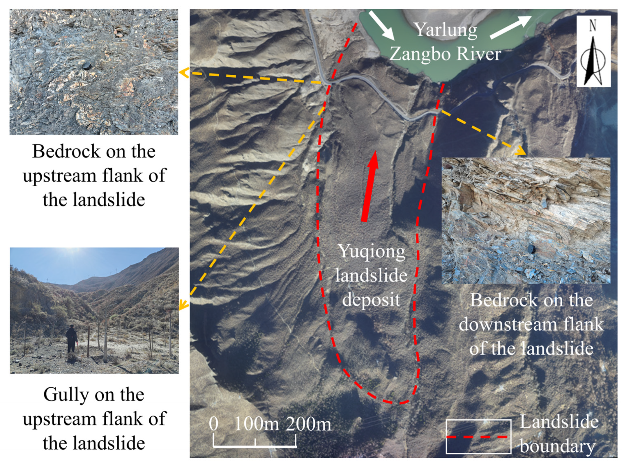
The study area, situated in the middle reaches of the Yarlung Zangbo River main stream within the Tibet Autonomous Region, features terrain that descends from west to east, with mountain ranges on both banks extending approximately east–west (Figure 1). Elevations generally range from 3500 to 5000 m, whereas the riverbed elevation varies between approximately 3115 and 3150 m, with relative elevation differences typically exceeding 700 m, forming a mountain–plateau lake basin landform. Within the study area, the Yarlung Zangbo River valley is deeply incised in a “U” shape, with a relatively wide channel and well-preserved terraces on both banks. During the normal water period, the river surface width generally ranges from 150 to 400 m, and the water depth varies between 3.0 and 10.0 m. The normal water level of the river is recorded as 3152 m.
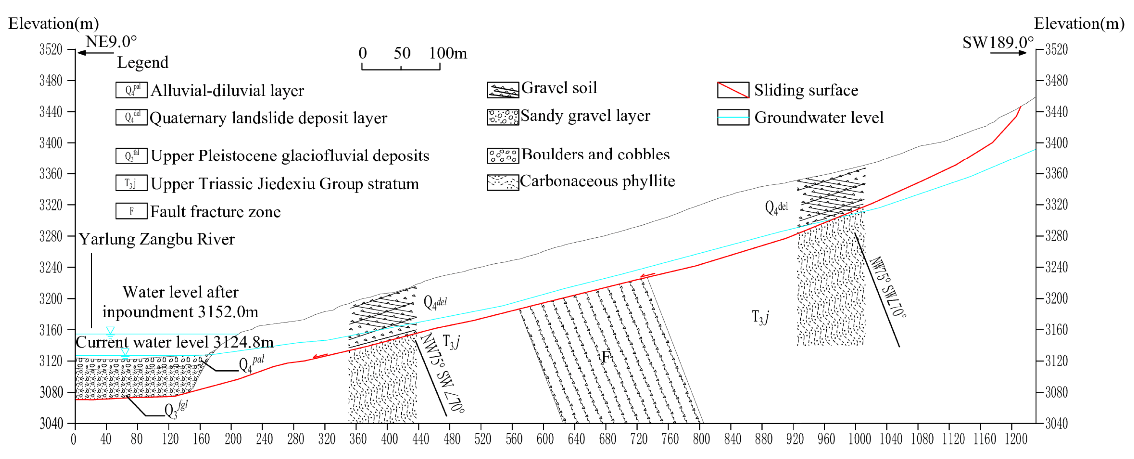
Based on the field investigation results and borehole data of the Yuqiong landslide deposit, the main stratigraphy of the study area and the material composition of the Yuqiong landslide deposit were determined (Figure 2).

2.1.1. Sliding Mass

The slope structure of the Yuqiong landslide deposit is mainly divided into two layers. The surface layer consists of fine silty sand, approximately 0.3–2 m thick, yellowish-brown in color, with particle sizes ranging from 1 to 2 mm. The particles are well-rounded but poorly cemented, and small gullies formed by water erosion are present within this layer. The underlying layer is composed of dark brown gravelly soil with variable particle sizes ranging from 1 to 10 cm. The main components are silt and clay, while the gravel and cobbles are predominantly angular phyllite, accounting for 30–40% of the content. These coarse particles are poorly rounded but well cemented.

2.1.2. Sliding Zone

According to the borehole data from the Yuqiong landslide site, the burial depth of the slip zone decreases with increasing elevation. The slip zone soil consists of gravel- and pebble-bearing dark gray clayey sand or silty sand. The gravel and pebbles are mainly composed of low-strength phyllite fragments, which exhibit a slippery feel and most of which disintegrate when pinched by hand. The submerged portion of the slip zone soil is in a soft plastic state, whereas the portion above the water table is in a plastic-to-hard plastic state.

2.1.3. Sliding Bed

Based on the field investigation results, borehole data, and geological information of the study area, the sliding bed of the Yuqiong landslide is identified as the carbonaceous quartz sericite phyllite of the Upper Triassic Jiedexiu Formation.

2.2. Weather Conditions

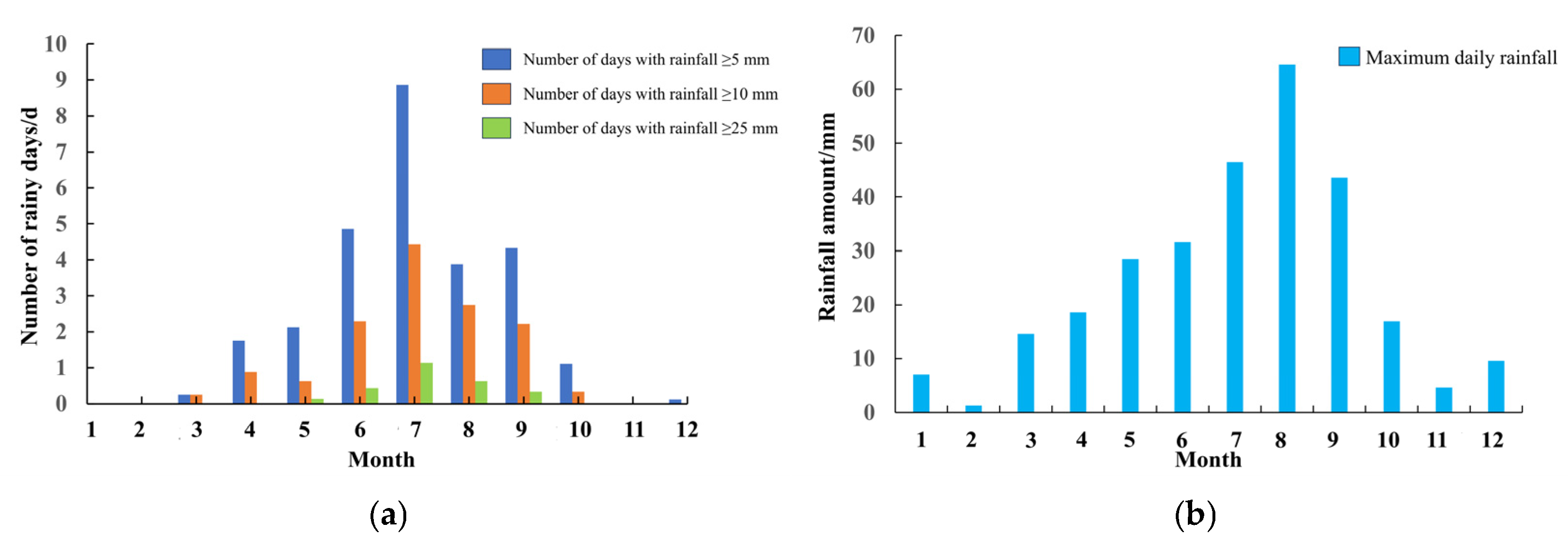
Influenced by the plateau monsoon, mesoscale topographic effects, water vapor transport through the Yarlung Zangbo River valley, high altitude, steep terrain, and thin air, the study area receives relatively low and seasonally uneven precipitation. The rainfall exhibits several distinctive characteristics: a generally low total amount, extremely uneven seasonal distribution, predominantly nocturnal rainfall, and significant spatial variability [34]. The annual precipitation ranges from 350 to 600 mm, with a multi-year average of approximately 550 mm. The maximum monthly precipitation reaches 391.6 mm, and the maximum daily precipitation is 64.6 mm. The rainy season is concentrated from June to September, accounting for more than 90% of the annual precipitation. During this period, rainfall is characterized by its intensity and concentration, often occurring as intense downpours of short duration. Rainfall data for the study area, obtained from the Langxian Meteorological Station in Nyingchi City, are presented in Figure 3.

2.3. Engineering Geological Conditions

The Yuqiong landslide deposit is developed on the concave bank at a bend of the Yarlung Zangbo River. The river valleys on the two banks are asymmetric: the left bank is a terrace, whereas the right bank is a concave slope. The overall slope gradient of the landslide ranges from 10° to 25°, although it varies considerably across the deposit. The surface slope changes notably with an elevation of 3373 m as the boundary: below this elevation, the ground slope is relatively gentle at approximately 10°, while above it, the terrain is steeper, with ground slopes ranging from 10° to 25°.
Based on previously collected geological data of the study area and field investigations, the exposed strata within the study area mainly include metamorphic rocks of the Upper Triassic Jiedexiu Formation (T3j) and Jiangxiong Formation (T3jx), as well as loose accumulations such as Quaternary glaciofluvial deposits (Q3fgl), alluvial deposits (Q4al), pluvial–alluvial deposits (Q4pal), and colluvial–deluvial deposits (Q4col + dl).
The study area is located within the Yarlung Zangbo Suture Zone, near its northern boundary fault. Two regional faults are also developed in this area: Fault F54 is situated on the south bank of the Yarlung Zangbo River, serving as a stratigraphic boundary fault and classified as a Grade I structural plane; Fault F62 is developed on the north bank, also a Grade I structural plane. The strike of these two faults is approximately parallel to the Yarlung Zangbo River valley.
The Yarlung Zangbo River valley serves as the lowest erosion base level in the study area. Based on differences in storage space and aquifer properties, the groundwater in the region can be divided into two types: bedrock fissure water and pore phreatic water in Quaternary loose accumulations.

3. Methodology

3.1. Massflow Principle

Massflow (v2.9.5) is numerical simulation software based on the depth-integrated continuum mechanics method and applying hydrodynamic equations. It is capable of simulating the dynamic evolution processes of mountain hazards such as landslides, debris flows, and mudflows under complex terrain conditions [35].
In Massflow, the numerical solution employs the MacCormack–TVD finite difference algorithm (Equation (1)), together with an adaptive algorithm and a mesh remeshing algorithm (Equation (2)). The governing equations adopted in this paper, namely the generalized depth-integrated continuum mechanics equations, are solved numerically using the MacCormack–TVD finite difference scheme, which is second-order accurate in both time and space.
X t + F x = S , X t + G y = T
In the numerical solution, the time advancement of the unknowns in the governing equations is achieved using the Strang-type operator splitting technique. The specific adaptive algorithm and mesh remeshing algorithm are described as follows:
X i , j n + 1 = L x 2 Δ t 2 L y 2 Δ t 2 L y 1 Δ t 2 L x 1 Δ t 2 X i , j n
where Lx and Ly denote a predictor–corrector–average computational step in the X and Y directions, respectively. Each splitting operator is required to be performed twice in order to obtain the results at the next time step.
The Courant number Cr, used for calculating the time step, is defined as shown in Equation (3):
C r = ( | u | + g h ) Δ t 2 Δ x

3.2. Laboratory Parameter Acquisition

To obtain the physical and mechanical properties of the saturated soil of the Yuqiong landslide deposit, X-ray diffraction tests, water content tests, and direct shear tests on specimens under different rock contents and different water contents were conducted.
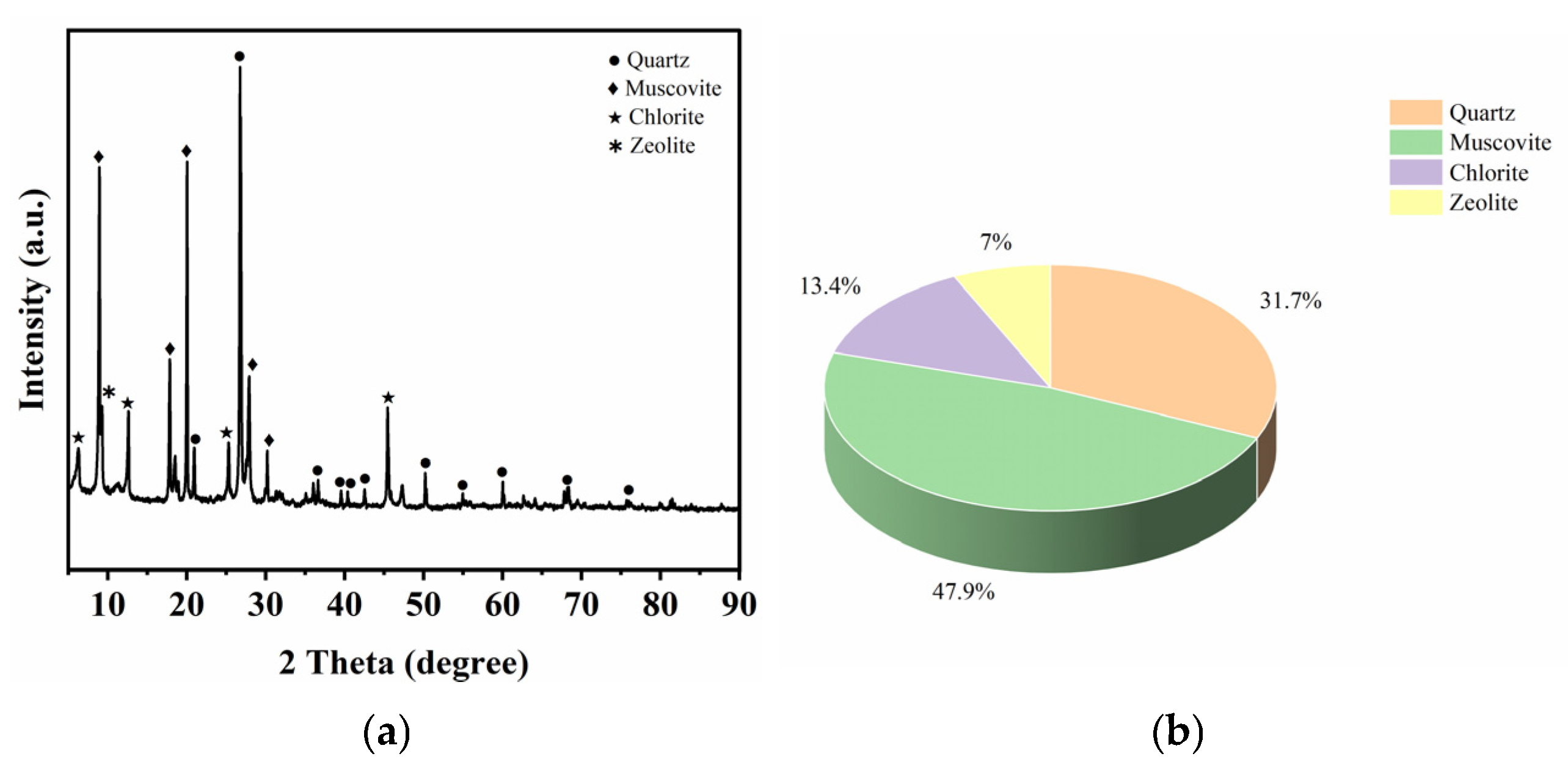
The results of the X-ray diffraction tests are shown in Figure 4. It can be seen that the main mineral components of the gravelly soil in the landslide mass are muscovite (47.9%), quartz (31.7%), chlorite (13.4%), and zeolite (7.0%). Muscovite and quartz are primary minerals (79.6%) formed from the parent rock through physical weathering; they belong to phyllosilicate minerals and exhibit a low degree of weathering. In contrast, chlorite and zeolite are secondary clay minerals (20.4%) formed from primary minerals through chemical weathering. These are hydrous tectosilicate minerals and possess certain water-sensitive characteristics.
The water content tests indicate that the natural and saturated water contents of the Yuqiong landslide deposit are 9.2% and 20.3%, respectively. Field investigation results show that the gravel content in the gravelly soil of the Yuqiong landslide deposit ranges from 30% to 40%, with variations across different zones. These differences in water content and gravel content in different zones of the landslide mass significantly affect the shear strength of the landslide soil. To investigate the variation characteristics of the shear strength of the landslide deposit under rainfall and subsequent reservoir impoundment conditions, direct shear tests were conducted on remolded specimens prepared with different water contents (9.2%, 13%, 17%, 20.3%) and different rock contents (30%, 35%, 40%).
The direct shear tests were conducted in accordance with the Chinese Standard GB/T 50123-2019 (Standard for Geotechnical Testing Method) [36]. Specimens were prepared as follows: the natural soil was sieved to remove particles larger than 10 mm. To better represent the gravel size of the sliding-mass soil in the field, gravel particles of 10 mm in diameter were mixed with the landslide soil. Controlled amounts of gravel (30%, 35%, and 40% by dry weight) and distilled water were added to achieve the target water contents (9.2%, 13%, 17%, and 20.3%). The mixtures were compacted in a ring sampler with an inner diameter of 61.8 mm and a height of 20 mm. The prepared specimens were cured for one day before shearing. During shearing, four normal stress levels (100 kPa, 200 kPa, 300 kPa, and 400 kPa) were applied, and the shearing rate was set to 0.8 mm/min. The shear failure was defined as the peak shear stress; in the absence of a clear peak, the shear stress at a shear displacement of 5 mm was adopted. The test results are presented in Table 1.

3.3. Establishment of the Computational Model and Calculation Settings

  • Establishment of the computational model
Three-dimensional models of the surface topography and sliding mass were constructed in ArcGIS (ArcGIS10.8) based on the CAD (CAD2020) contour map and cross-sections of the Yuqiong landslide deposit, and then imported into Massflow (Massflow2.9.5) to generate the computational model under gravity.
2.
Calculation parameter settings
Massflow primarily provides models such as the Coulomb friction model (applicable to debris flows, including landslides and rockfalls), the Bingham model (applicable to dam-break and flood hazards), and the Manning model (applicable to debris flows). To achieve optimal simulation results for the movement of the Yuqiong landslide deposit, and considering the basic geological data of the study area, as well as the characteristics and kinematic nature of the deposit, the Coulomb model—a basal friction model—was selected. This model was employed to simulate the potential deformation, instability process, and movement characteristics of the landslide under the most unfavourable conditions, namely saturated water content and low gravel content. By inputting the basal friction coefficient, this model influences the maximum travel distance and deposition extent of the landslide, enabling the results to more closely approximate real conditions. The calculation formula is shown in Equation (4). Based on the landslide scale and simulation extent, the total simulation duration was preliminarily set to 100 s, with an initial time step of 0.01 s. The selection of 100 s as the total simulation duration was based on the following considerations: (1) preliminary simulation results indicate that the landslide movement essentially ceases after approximately 90–100 s, with the velocity decaying to near-zero values; (2) beyond 90 s, the deposit thickness and accumulation extent show no significant changes.
τ b = c + ρ g h ( 1 λ ) tan ( φ )
where τ b is the basal shear stress (kPa); ρ is the average density of the fluid (kg/m3); λ is the pore water pressure ratio; g is the gravitational acceleration (m/s2); φ is the internal friction angle; and c is the cohesion (kPa).
Since the selection of calculation parameters has a certain influence on the simulation results, the material parameters in the simulation were comprehensively determined based on the basic geological data of the study area, previous field tests, and laboratory shear strength test results of the landslide soil. The density of the landslide soil was derived from previous field tests. As the rock content decreases, the coarse particle skeleton effect weakens, and the shear strength is mainly provided by the fine-grained matrix, making the soil more prone to flow-sliding deformation under saturated conditions. To make the most conservative prediction of the shear strength of the landslide mass under reservoir impoundment and rainfall, the most unfavorable combination of water content and rock content was adopted to simulate and predict the movement process of the landslide deposit. Accordingly, the internal friction angle and cohesion were determined based on the laboratory shear strength test results under 30% rock content and saturated water content. The coefficient of friction was set to 0.4 based on the landslide geometry and comparisons with similar reservoir-bank landslide deposits [35]. The pore pressure coefficient of 0.3 was adopted following the engineering geological analogy method, with reference to previous studies on saturated landslide deposits under rainfall and reservoir impoundment conditions [31]. The main calculation parameters are listed in Table 2.

3.4. Monitoring Point Arrangement

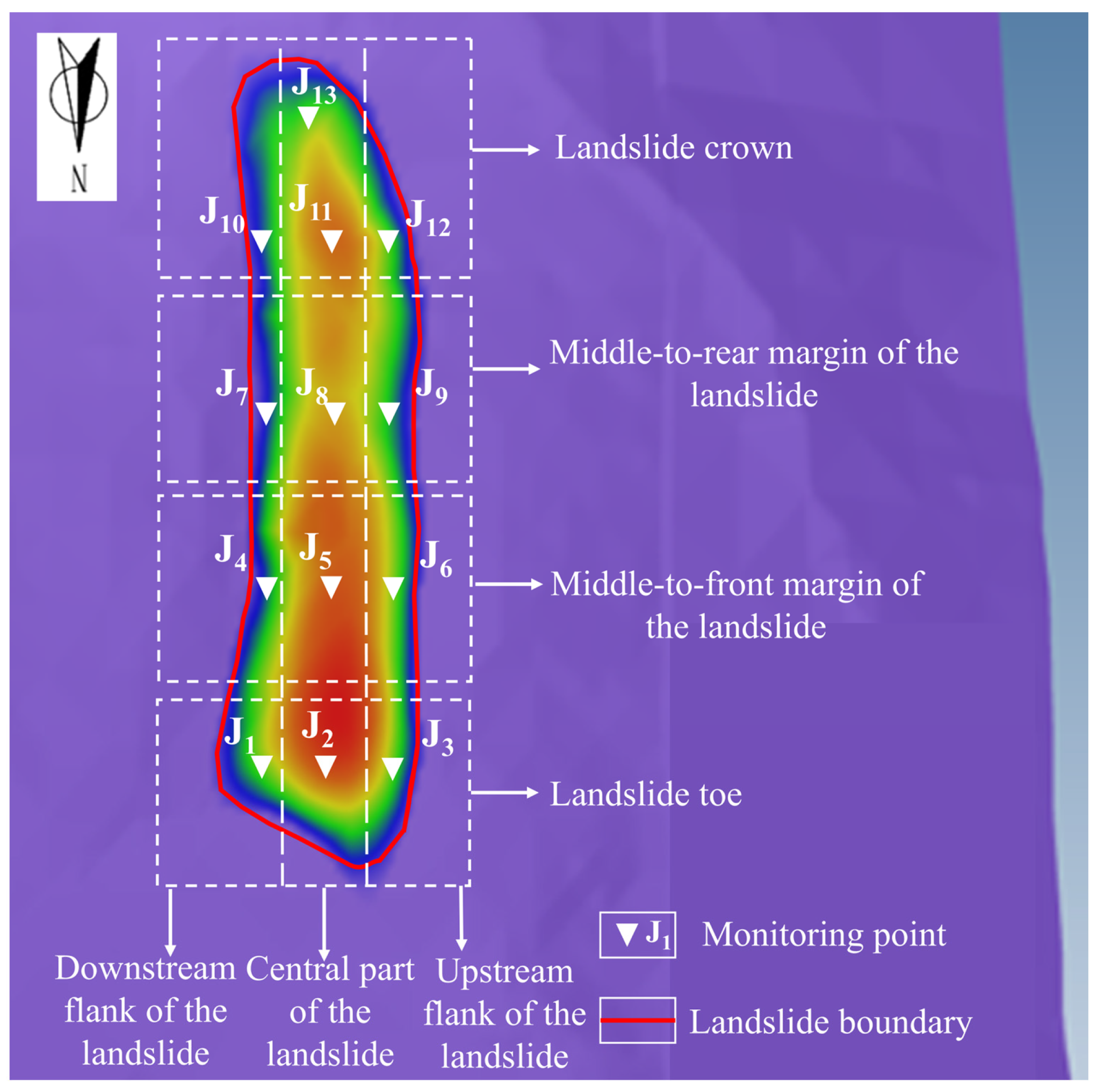
To analyze the movement state, deformation mode, and accumulation characteristics of the Yuqiong landslide deposit under saturated water content and low rock content conditions, monitoring points were respectively placed at the toe (J1, J2, J3), the middle-to-front part (J4, J5, J6), the middle-to-rear part (J7, J8, J9), and the crown (J10, J11, J12) of the Yuqiong landslide deposit. Based on the information obtained from the simulations of the movement process of the Yuqiong landslide deposit—including the deposit thickness H at different times, the movement velocity in the X direction (the transverse direction of the landslide, U), the movement velocity in the Y direction (the longitudinal direction of the landslide, V), and the energy characteristics of the landslide deposit (Hvvmax is defined as the maximum value, over the entire simulation duration, of the product of flow height and the square of velocity at each grid cell; a higher value of this parameter indicates a greater concentration of kinetic energy at that specific location and time, implying that the corresponding area experiences the highest impact energy or destructive potential during the landslide process)—the deformation and instability mode as well as the potential instability zones of the Yuqiong landslide deposit under saturated water content and low rock content conditions were analyzed. Furthermore, the movement characteristics of the landslide deposit upon failure were analyzed and described. The arrangement of the monitoring points for the Yuqiong landslide deposit is shown in Figure 5.

4. Results of Numerical Modelling

4.1. Characteristics of Thickness Variation in Landslide Deposits

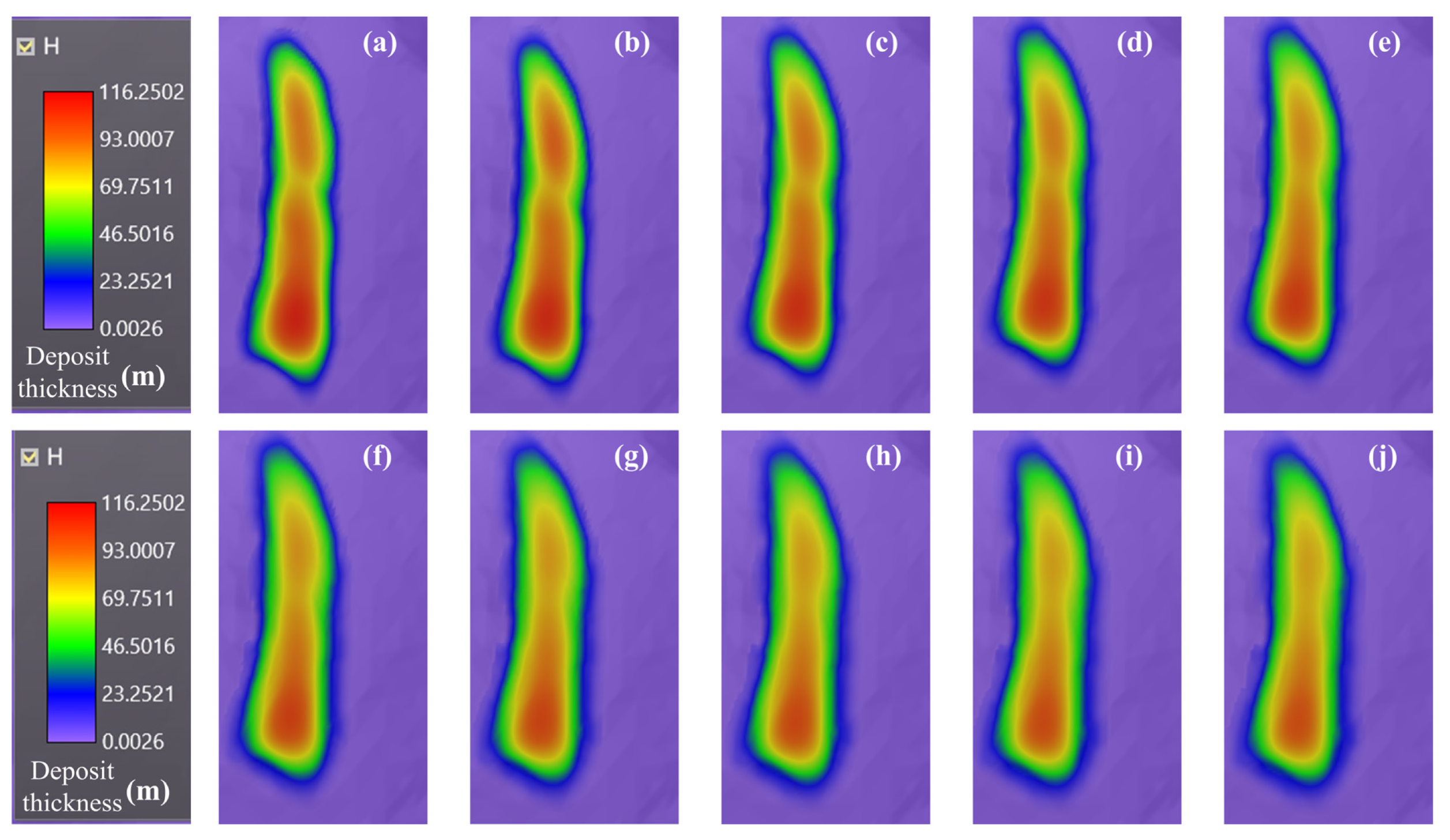
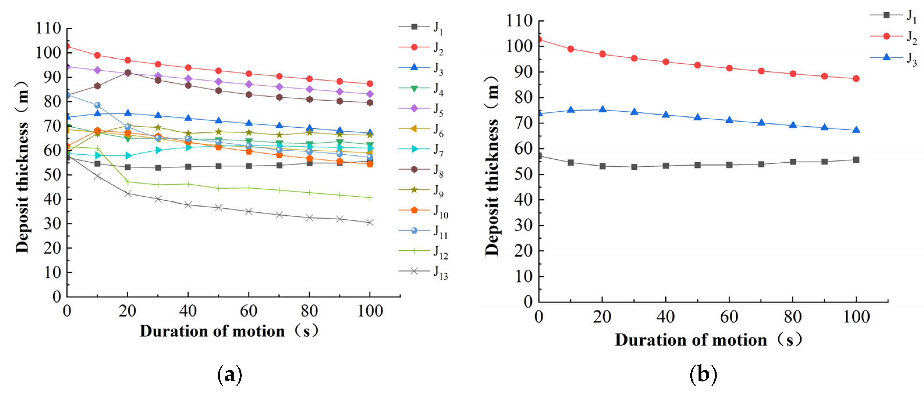
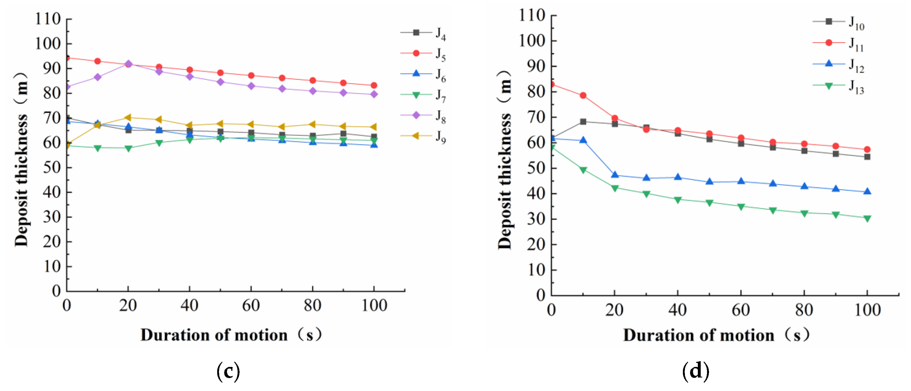
To clarify the deformation and instability process of the Yuqiong landslide deposit under saturated water content and minimum rock content conditions, the movement states and deposit thickness variations at different times during sliding were extracted from the numerical simulation. The accumulation states of the landslide at different times are presented in Figure 6, and the corresponding thickness variation curves are shown in Figure 7. Based on these simulation results, the deformation-instability mode and movement characteristics of the landslide deposit were analyzed.
The total simulation duration is 100 s, by which time the landslide has essentially ceased movement. The overall movement process is illustrated in Figure 7. The movement characteristics of the deposit vary considerably across different periods. Based on the accumulation states and thickness variation curves at different times (Figure 8 and Figure 9), the deformation and failure process can be divided into four stages: the initiation and sliding stage (0–20 s), the deformation propagation stage (20–70 s), the deformation accumulation stage (70–80 s), and the cessation stage (80–100 s).
The period from 0 s to 20 s represents the initiation and sliding stage of the landslide. As shown in Figure 6a,b, two significant deformation zones form at the toe and crown immediately upon movement initiation. According to Figure 7d, the deposit thickness in various zones at the crown decreases rapidly during the initial 0–20 s interval, and the steep slope at the crown provides a substantial gravitational potential energy that drives downward deformation of the landslide. As indicated in Figure 6c, the deposit thickness in certain areas of the middle-to-rear part increases rapidly within the first 20 s, suggesting that the crown undergoes intense deformation and rapidly expands downward under gravitational potential energy. In contrast, the deposit thickness in the middle-to-front part decreases slowly at the initial stage, promoting gradual downward deformation of this region. As shown in Figure 6b, toe deformation propagates from the central portion of the toe toward both lateral boundaries. Because the downstream flank of the landslide is composed of bedrock, the deformation encounters resistance, leading to an increase in deposit thickness along the downstream flank.
The period from 20 s to 70 s represents the deformation propagation stage of the landslide. As shown in Figure 6c,d, the deforming mass in the middle-to-rear part of the landslide body continues to propagate and deform downward into the large-deformation zone. According to Figure 7d, the deposit thickness at the crown changes little during this period, whereas Figure 7c indicates that the deposit thickness in the middle-to-rear part gradually decreases and deformation is primarily directed toward the upstream flank of the landslide, while the middle-to-front part and the toe undergo slow deformation. As indicated in Figure 7b, the deposit thickness variation curve for the upstream flank changes from decreasing to slowly increasing, suggesting that toe deformation is influenced by the downcutting depth of the gully on the upstream flank, with the central portion of the toe deforming more intensely toward the upstream side.
The period from 70 s to 80 s represents the deformation accumulation stage of the landslide. As shown in Figure 6f–h, the two deformation zones at the toe and crown have gradually merged into an integrated deforming body. During this period, as shown in Figure 7b–d, the deposit thickness variation curve at the crown gradually flattens, and crown deformation becomes progressively stable. In contrast, the slope of the deposit thickness variation curve for the middle-to-front part remains unchanged, indicating that this region continues to deform slowly downward.
The period from 80 s to 100 s represents the landslide cessation stage. As shown in Figure 6i,j, the deposit thickness in various zones of the landslide remains essentially unchanged, and deformation at both the toe and crown gradually stabilizes. According to Figure 7b, the deposit thickness variation curves for different zones at the toe remain largely flat, indicating that the local deformation zones at the toe are in a stable state and exhibit fan-shaped accumulation. As indicated in Figure 7c,d, deformation in the middle-to-rear part and at the crown tends toward stability.

4.2. Characteristics of Velocity Variation in Landslides

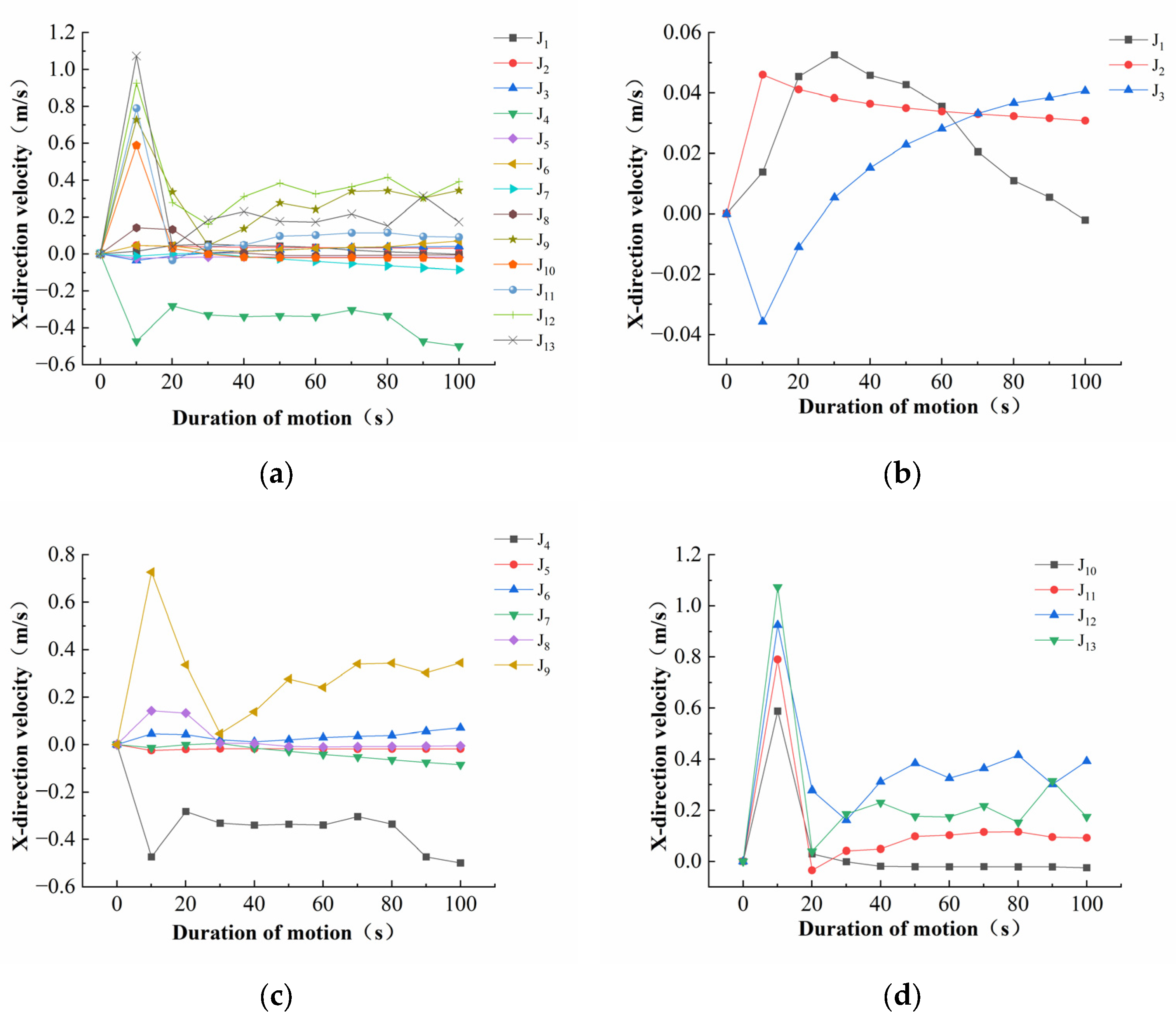
To analyze the velocity variation characteristics of the Yuqiong landslide deposit during deformation and failure under saturated water content conditions, the velocity variation data from monitoring points located in different zones of the deposit were extracted, primarily comprising the X-direction and Y-direction velocities. The velocity–time variation characteristics at different positions of the landslide were subsequently analyzed. Figure 8 presents the X-direction velocity–time curves for different zones of the landslide deposit at various times. The total simulation duration for the movement of the landslide deposit is 100 s, by which time the landslide has essentially ceased movement. The X-direction velocity variation is mainly concentrated at the landslide boundaries, particularly at the crown and the upstream and downstream flanks. Deformation propagates from the central part toward both the upstream and downstream flanks. The downstream flank, being in direct contact with the bedrock, exerts a resistive effect on landslide deformation. In contrast, the upstream flank is characterized by a deep gully between the deposit and the bedrock, which lacks effective obstruction to landslide movement and thus facilitates downward deformation.
In the early stage of landslide movement, the velocity variation is predominantly concentrated at the steep crown and the central portion of the downstream flank, indicating that under saturated water content conditions, the increased weight of the crown, combined with the steep crown topography, renders the crown the primary driving force for downward deformation. With increasing sliding time, the velocity variation zone extends downward from the crown along the upstream and downstream flanks of the Yuqiong landslide deposit. Ultimately, as the landslide deposit ceases movement and accumulates, the central portion of the deposit gradually extends toward both the upstream and downstream flanks, suggesting that the deposit tends to stabilize and eventually evolves into a fan-shaped accumulation.
According to the velocity curves of monitoring points at the toe, middle-to-front part, middle-to-rear part, and crown of the Yuqiong landslide deposit (Figure 8), the X-direction velocity variation can be divided into three main stages: the start-up acceleration stage (0–10 s), the rapid deceleration stage (10–20 s), and the slow deformation stage (20–100 s). As shown in Figure 8c,d, the 0 s–10 s interval corresponds to the acceleration stage. During this stage, the velocities at the crown and middle-to-rear part increase sharply, driving the landslide mass to deform and propagate downward, whereas the velocities at the toe remain relatively low. Monitoring point J3 at the toe deforms toward the downstream flank, while the other toe monitoring points slowly deform toward the upstream flank. The 10–20 s interval represents the rapid deceleration stage. During this period, the X-direction velocities at the crown and middle-to-rear part decrease sharply from a peak value of 1.1 m/s. The 20–100 s interval constitutes the slow deformation stage, during which the kinetic energy of the landslide gradually decreases with increasing movement time until sliding ceases and energy is fully dissipated.
In the overall movement process of the landslide, the start-up acceleration stage lasts less than 10 s, accounting for 10% of the entire movement process, whereas the rapid deceleration and slow deformation stages together account for the remaining 90%. This indicates that the collapse and rapid sliding of the deposit material at the crown can provide energy for unstable deformation, enabling the velocity to reach its maximum within a short period. Consequently, the sliding deformation of the landslide deposit is characterized by a certain degree of suddenness.
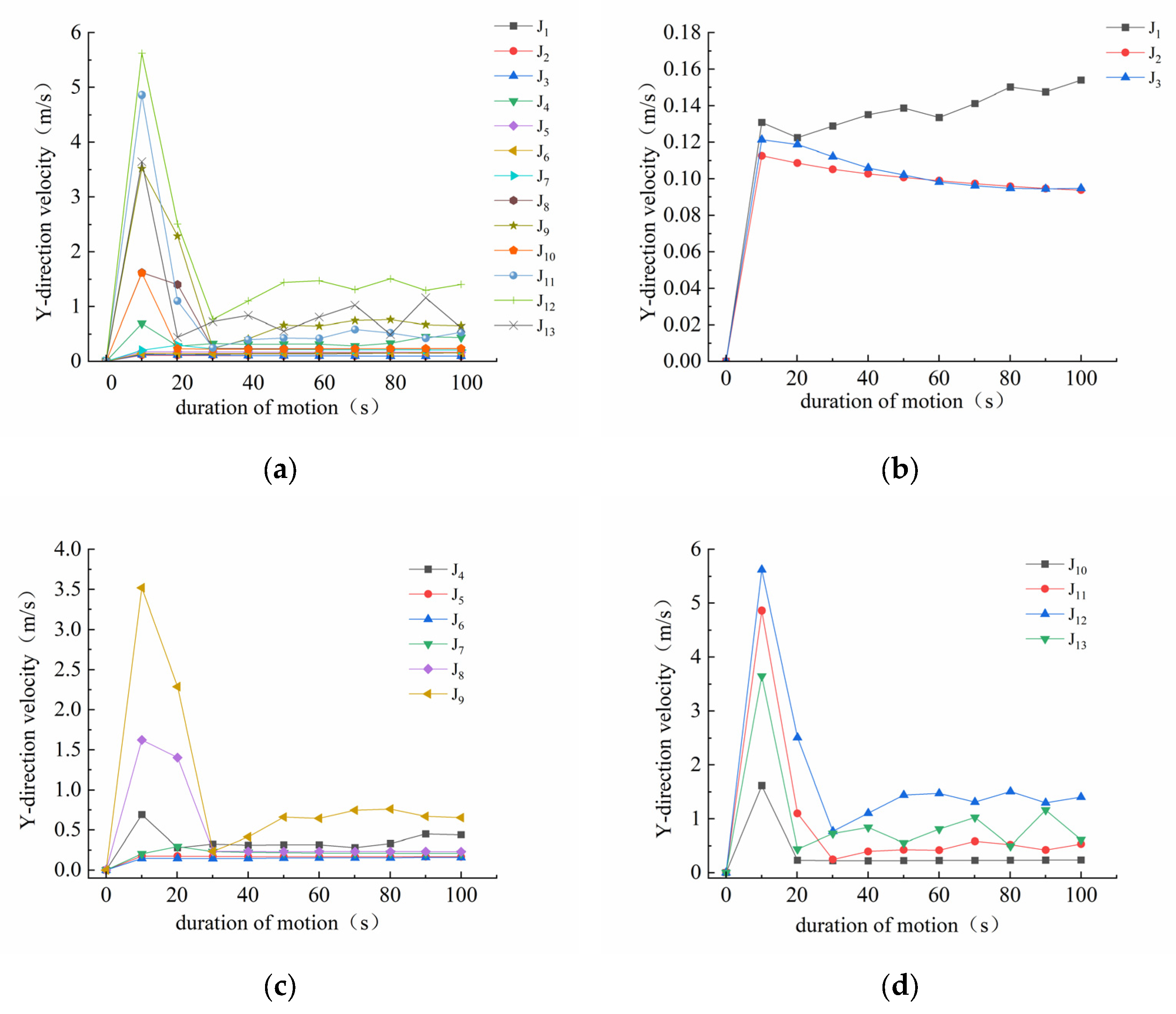
The Y-direction velocity variation of the Yuqiong landslide deposit is primarily concentrated at the steep sections of the crown and the downstream flank. As sliding time increases, the velocity variation zone expands from these steep areas toward both lateral flanks, indicating that instability at the crown promotes downward deformation of the landslide deposit. As shown in Figure 9, the Y-direction velocity variation stages can be divided into the start-up acceleration stage, rapid deceleration stage, and slow deformation stage, consistent with the velocity trend in the X direction. Moreover, the maximum Y-direction velocity (5.5 m/s) is substantially greater than that in the X direction (1.1 m/s), indicating that the Yuqiong landslide deposit deforms predominantly in the Y direction.

4.3. Characteristics of Energy Distribution in Landslides

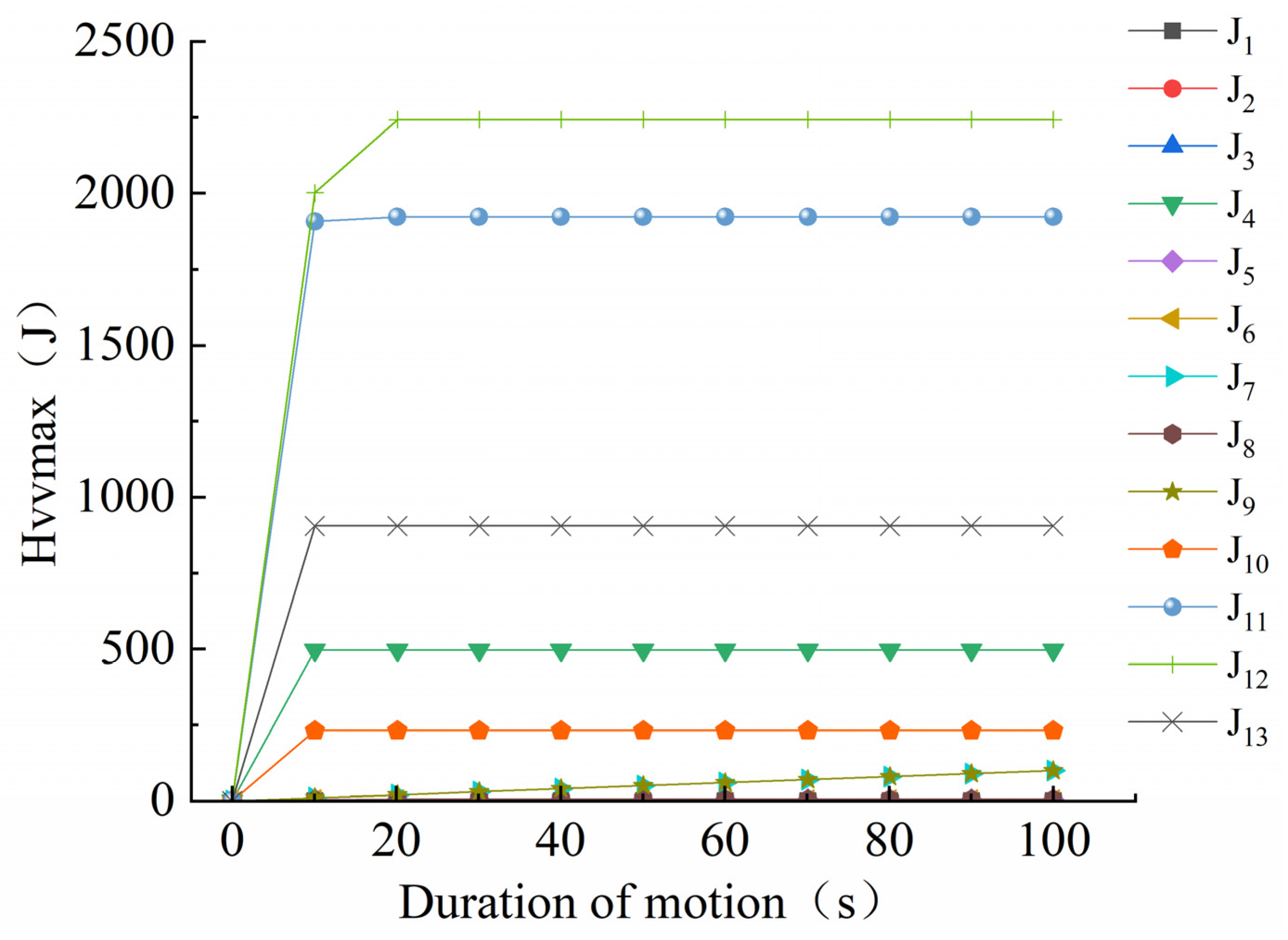
To analyze the energy characteristics of the deformation process of the Yuqiong landslide deposit, the energy–time curves obtained from monitoring points in different zones of the deposit (Figure 10) were examined. The sliding surface of the deposit exhibits a chair-like profile, which is gentle at the toe and steep at the crown. During the initiation and acceleration stage, the steep crown and the significant elevation difference provide a relatively high initial velocity for landslide movement. The majority of the energy is concentrated at the steep crown along the upstream flank, while a smaller portion is concentrated in the middle-to-front part near the relatively steep area of the downstream flank. This variation in energy distribution across different zones reflects the direction of landslide deformation; specifically, the deposit deforms predominantly toward the upstream flank and to a lesser extent toward the downstream flank.
As shown in Figure 10, the energy at the landslide crown increases rapidly (J13). As the thickness of the sliding mass increases, the Y-direction velocity continues to rise, and the energy reaches its peak at the crown (J11, J12). With decreasing slope gradient and increasing sliding distance and sliding mass thickness, the resistance to downward movement increases, leading to a reduction in sliding velocity. Consequently, the landslide enters a stage of slow deformation. During this stage, the material within the landslide deforms slowly downward, with fan-shaped accumulation at the toe, while the landslide energy decreases rapidly (J4, J8, J1, J7) and approaches an equilibrium state. The energy characteristics of the landslide deposit (Figure 10) indicate that, under saturated water content and low rock content conditions, the crown of the Yuqiong landslide deposit behaves in a manner characteristic of a thrust-type landslide.

5. Discussion

5.1. Deformation and Failure Characteristics and Mechanism of the Yuqiong Landslide Deposit

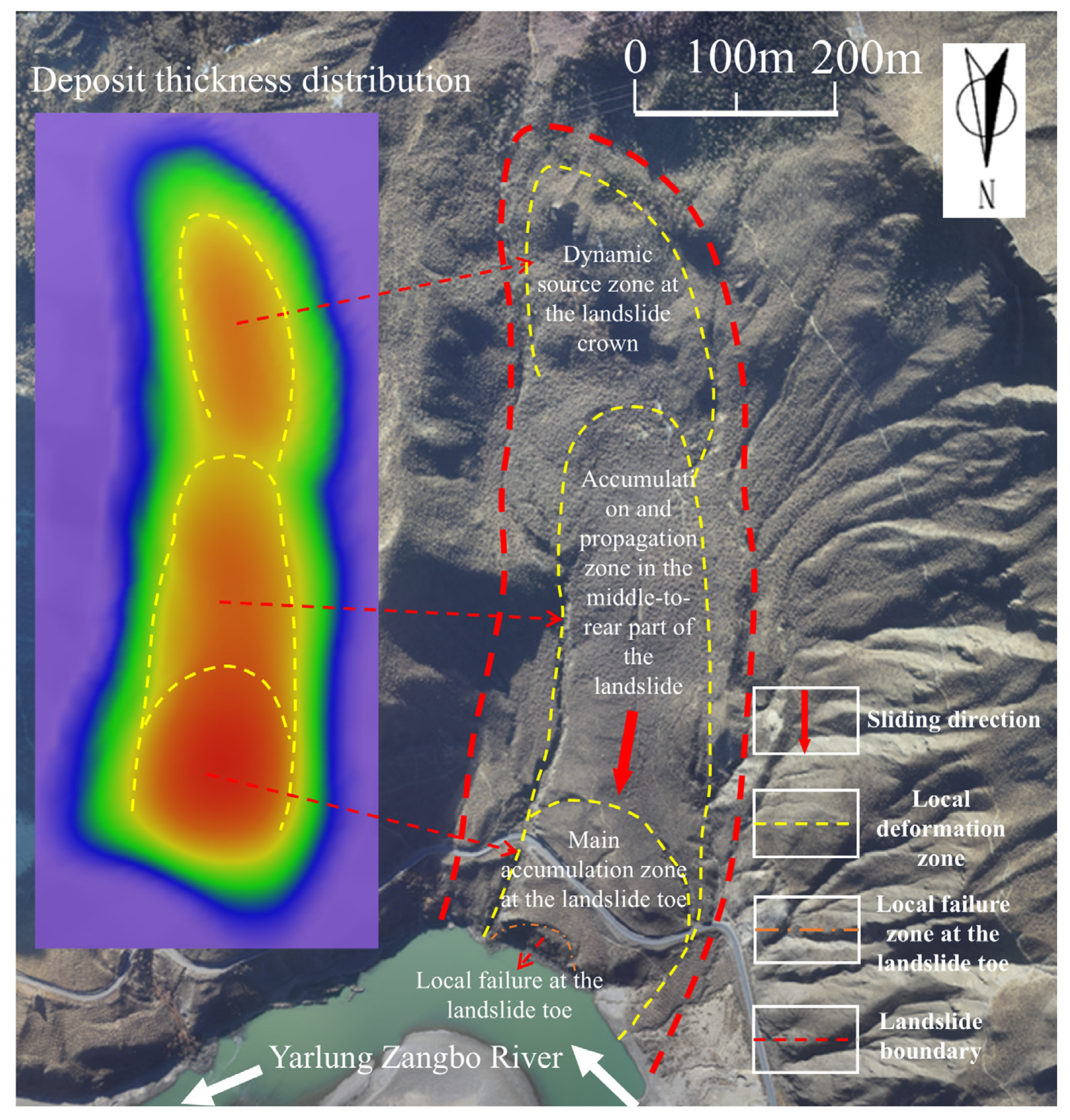
Drawing on field investigation data, geological conditions of the landslide mass, and numerical simulation results (Figure 11), the deformation and instability of the Yuqiong landslide deposit are found to be discontinuous in nature. Moreover, the degrees and rates of deformation at the toe, crown, and middle part of the landslide vary significantly from one another.
(1)
According to the landslide profile, the sliding surface exhibits a chair-like geometry that is gentle at the toe and steep at the crown. The steep crown facilitates rainwater convergence, which wets the soil and reduces the shear strength of the landslide mass. In addition, the relatively thin soil at the crown is prone to saturation under rainfall, allowing water to percolate deeper into the landslide. As the unit weight of the soil increases, the driving force at the crown rises, promoting downward deformation. This is consistent with the Y-direction velocity at monitoring point J12 reaching a peak value of 5.5 m/s within a short period, corresponding to the maximum energy at this location.
(2)
The middle-to-rear part of the landslide mass directly bears the downward thrust from the crown, exhibiting velocity and energy levels second only to those of the crown. However, due to the gentler slope and extended sliding path at the toe and the middle-to-front part, frictional energy dissipation is significant, resulting in relatively small deformation. Under such a non-uniform energy distribution, the driving force acting on the middle-to-rear soil continues to increase under the dual effects of crown thrust and rainfall saturation, generating a tensile stress field and inducing local subsidence. The middle-to-front part, characterized by small deformation and low velocity, acts as a retarding element, slowing the rapid sliding of the middle-to-rear part. Meanwhile, the retrogressive effect of the slowly accumulating toe induces local subsidence and deposition in the middle-to-front part. Consequently, the middle part represents a mechanically superimposed zone where crown thrusting and toe retrogressive action coexist, with its deformation response lying between the two.
(3)
The gentle slip surface angle and the thick deposit at the toe provide substantial sliding resistance to downward movement, resulting in X- and Y-direction velocities that are considerably lower at the toe than at the crown during movement. Under the combined effects of increased self-weight and thrust from the middle-to-rear part, the toe deposit slowly deforms downward with increasing thickness. The gradual development of internal shear deformation within the toe ultimately leads to local failure. The tensile stress induced by this local deformation causes pronounced subsidence at the rear of the middle-to-front part, which subsequently becomes the main accumulation zone.
Thus, when the soil becomes saturated and fails under reservoir impoundment and rainfall conditions, the steep crown provides the energy and driving force that propel the landslide downward. The toe, owing to its gentle slip surface, thick deposit, and high sliding resistance, undergoes slow deformation and provides retrogressive buffering accumulation. Meanwhile, the middle part experiences local settlement and stress transfer under the combined effects of crown thrusting and toe retrogressive action. Overall, this landslide exhibits a progressive composite failure mode, characterized by active thrusting at the crown, passive retrogressive adjustment at the toe, and stress transition in the middle part. This finding is consistent with the progressive retrogressive deformation mode of the chair-like landslide deposit reported in reference [10].
It should be acknowledged that the current study does not explicitly consider the effects of seismic loading or the detailed heterogeneity of geological structures. Incorporating these factors in future research will contribute to a more comprehensive understanding of landslide behaviour in this tectonically active region.

5.2. Influence of Parameter Variation on Simulation Results

Water content and gravel content are two key physical parameters affecting the stability and kinematic deformation of landslide masses. On one hand, an increase in water content weakens the shear strength of the soil [37,38]; on the other hand, it also increases the driving force of the landslide. Mineral composition analysis indicates that the slope material is mainly composed of quartz and potassium feldspar, which exhibit low water sensitivity. In addition, the slope material shows a low degree of weathering, so the reduction in strength with increasing water content is relatively limited. Direct shear tests under varying water contents reveal that when the water content increases from 9.2% to 20.3%, the maximum decreases in internal friction angle and cohesion are 23.7% and 31.5%, respectively.
Gravel content primarily affects the internal skeleton structure [39], the interlocking and extrusion effects between particles [40], and the permeability [41] of the soil. Within the moderate range of 30–40% gravel content, the gravel particles come into contact with one another, forming a skeleton structure. Under identical water content conditions, increasing the gravel content from 30% to 40% results in a 24.07% increase in the internal friction angle. Conversely, under the same gravel content, raising the water content from 9.2% to 20.3% leads to decreases in the internal friction angle of 23.7% and 15.73%, respectively. Under the combined influence of water content and gravel content, the overall variation in the internal friction angle is relatively small; consequently, the slope is not susceptible to rapid overall sliding. However, the interlocking and rotation of gravel particles may induce local strain concentrations and progressive deformation.
It should be noted that although the computational parameters adopted in the landslide movement simulation correspond to the most unfavorable combination of gravel content and water content, in reality these two parameters exhibit spatial variability across different parts of the slope, which may lead to differential deformation responses in various zones of the landslide. Therefore, the local deformation mode of the landslide is jointly governed by gravel content and water content: when the gravel content is relatively high, the skeleton drains quickly, and the influence of water content is relatively diminished; conversely, when the gravel content is relatively low, water content becomes the dominant factor and is more likely to induce plastic flow.

5.3. Limitations of the Study

In this study, Massflow was used to simulate and predict the potential failure modes of the Yuqiong landslide deposit under rainfall and subsequent reservoir impoundment conditions; however, certain limitations still exist.
The deformation and instability movement of the Yuqiong landslide deposit was predicted. However, due to the limitations of the actual site engineering, monitoring data for the landslide deposit are currently lacking. Subsequently, the landslide deformation results will be validated and analyzed in combination with landslide deformation monitoring data.
Although numerical simulation methods have been employed to predict and analyze the potential deformation and instability process of the Yuqiong landslide deposit, the physical and mechanical parameters (e.g., shear strength) at different locations of the slope vary due to the differential influence of water and rock content. Consequently, deviations exist between the numerical simulation results obtained under the conditions of minimum rock content and saturated water content in this study and the actual situation. Therefore, future research will refine the characterization of internal parameter variations within the landslide deposit, conduct numerical simulations coupled with seepage fields, and validate the rationality of the numerical simulation results using field monitoring data.
In addition, the present study focuses on a single conservative scenario, namely the most unfavorable combination of saturated water content and low gravel content. Although this approach is suitable for conservative hazard assessment, it does not fully reflect the potential variability of simulation outcomes under different parameter combinations. A systematic sensitivity analysis will be conducted in future work to examine the effects of variations in water content, gravel content, friction coefficient, and pore pressure coefficient on travel distance, deposit thickness, and velocity distribution, which will help to better quantify the uncertainty of the numerical model and further enhance the robustness of the predictions.

6. Conclusions

In this study, the instability movement process of the Yuqiong landslide deposit was predicted through field investigation, laboratory tests, and numerical simulation, and its deformation and failure mechanism was explored. The main conclusions are as follows:
(1)
The simulated movement duration of the Yuqiong landslide deposit is approximately 100 s. The deformation and instability process can be divided into four stages: the initiation and sliding stage, the deformation propagation stage, the deformation accumulation stage, and the cessation stage. In the initial stage, distinct deformation zones are observed at the toe and crown. The deformation zone at the crown gradually propagates downward and eventually merges with the deformation zone at the toe, forming a fan-shaped deposit.
(2)
The velocity variation of the Yuqiong landslide deposit can be divided into three stages: the start-up acceleration stage, the rapid deceleration stage, and the slow deformation stage. The initial acceleration stage accounts for 10% of the entire movement process, whereas the rapid deceleration and slow deformation stages together account for the remaining 90%. Deformation and instability at the crown can accelerate the landslide to a peak velocity of 5.5 m/s within a short period, indicating that the sliding deformation of the deposit exhibits a certain degree of suddenness.
(3)
The main factors affecting energy variation during movement of the Yuqiong landslide deposit are topographic gradient, deposit thickness, and sliding distance. At the crown, where the terrain is steep, the deposit is thick, and the sliding distance is short, frictional energy dissipation is low, resulting in a high energy concentration. In contrast, at the toe and middle part, where the slopes are gentler and the sliding distances are longer, energy dissipation is substantial, leading to relatively low energy distribution.
(4)
Upon deformation and failure, the landslide is driven by active thrust at the crown; the toe, owing to its gentle slope and thick deposit with high sliding resistance, undergoes slow retrogressive movement and provides buffering accumulation; the middle part, subjected to both thrusting and retrogressive actions, undergoes settlement and stress transfer. Overall, the landslide can be characterized as a composite progressive failure mode, involving crown thrusting and toe retrogressive action.

Author Contributions

Conceptualization, X.Z. and M.D.; Methodology, X.H. and F.Z.; Software, X.Z. and X.H.; Validation, M.D. and X.Z.; Formal analysis, X.H. and F.Z.; Investigation, Y.H., F.Z., X.Z. and M.D.; Resources, Y.H. and F.Z.; Data curation, X.Z., M.D. and Y.H.; Writing—original draft, X.Z.; Writing—review and editing, M.D.; Supervision, X.H.; Project administration, X.Z. All authors have read and agreed to the published version of the manuscript.

Funding

This research was funded by the Fundamental Central University Fund (1071/423061) and the Research Project Fund of the PowerChina Beijing Engineering Corporation (No. 824144016).

Institutional Review Board Statement

Not applicable.

Informed Consent Statement

Not applicable.

Data Availability Statement

The original contributions presented in this study are included in the article. Further inquiries can be directed to the corresponding author.

Conflicts of Interest

Author Yuezu Huang was employed by the company PowerChina Beijing Engineering Corporation, and the author Xinjie Han was employed by Zhejiang Design Institute of Water Conservancy and Hydroelectric Power (ZDWP). The remaining authors declare that the research was conducted in the absence of any commercial or financial relationships that could be construed as a potential conflict of interest. The sponsors had no role in the design, execution, interpretation, or writing of the study.

References

  1. Ran, T.; Xu, R.G.; Zhou, H.F.; Zhang, J.H.; Chen, H.; Wang, Y.K.; Sun, J.; Cui, Y.Z. Type, formation mechanism and distribution regularity of landslides in the deeply incised valley area of Yalong River Basin—A case study of Zituoxi-Malangcuo river section. Geol. China 2024, 51, 511–524, (In Chinese with English abstract). [Google Scholar]
  2. Zhang, T.T.; Li, B.; Gao, Y.; Gao, H.Y.; Yin, Y.P. Massive glacier-related geohazard chains and dynamics analysis at the Yarlung Zangbo River downstream of southeastern Tibetan Plateau. Bull. Eng. Geol. Environ. 2023, 82, 426. [Google Scholar] [CrossRef]
  3. Du, G.L.; Zou, L.; Yang, Z.H.; Sun, D.Y.; Gu, L.Y. A study on the development and distribution characteristics of landslides in the region of the Grand Bend of the Yarlung Zangbo River and their response to geomorphic evolution. Acta Geol. Sin. 2021, 98, 3062–3076. [Google Scholar]
  4. Yang, C.Y.; Zhang, X.; Li, R.M.; Bo, W.; Liu, D. Analysis on the Development Characteristics and Resurrection Trendof Geological Hazards in Sedongpu Gully of Yarlung Zangbo Riverbased on SBAS-InSAR Technology. Plateau Sci. Res. 2024, 8, 1–13. [Google Scholar] [CrossRef]
  5. Jia, W.J.; Wen, T.; Wang, Y.K.; Chen, N.S. Deformation and failure mechanisms of shallow landslides in the Qinghai-Tibet Plateau, China: A case study of Zhaxuecun landslide. Bull. Eng. Geol. Environ. 2026, 85, 133. [Google Scholar] [CrossRef]
  6. Chen, L.G.; Yang, C.M.; Xie, J.; Fan, L.G.; Pu, W.; Luo, R. Comprehensive analysis on formation mechanism and risks of Baiheping landslide in Three Gorges Reservoir area. Yangtze River 2025, 56, 123–133. [Google Scholar]
  7. Dun, J.W.; Feng, W.K.; Yi, X.Y.; Zhang, G.Q.; Wu, M.T. Early InSAR identification of active landslide before impoundment in Baihetan reservoir area—A case study of Hulukou town Xiangbiling section. J. Eng. Geol. 2023, 31, 479–492. [Google Scholar]
  8. Zhang, W.A.; Meng, X.Y.; Wang, L.Q.; Meng, F.S. Stability analysis of the reservoir bank landslide with weak interlayer considering the influence of multiple factors. Geomat. Nat. Hazards Risk 2022, 13, 2911–2924. [Google Scholar] [CrossRef]
  9. Fang, X.W.; Wang, Y.C.; Wang, L.Q.; Zhang, W.G.; Chen, C.; Deng, H.W. Evolution trend of reservoir bank landslides driven by numerical simulation and mechanism analysis. Bull. Eng. Geol. Environ. 2025, 84, 224. [Google Scholar] [CrossRef]
  10. Luo, S.L.; Liu, H.L.; Jiang, J.Q. Coupled influence of reservoir water and rainfall on the responsemechanism of accumulated landslides with chair-likeinterfaces between sliding masses and bedrock. J. Tsinghua Univ. Sci. Technol. 2024, 64, 1336–1346. [Google Scholar]
  11. Yang, H.; Lu, Y.F.; Wang, J. Stability Analysis of the Huasushu Slope Under the Coupling of Reservoir Level Decline and Rainfall. Appl. Sci. 2025, 15, 5781. [Google Scholar] [CrossRef]
  12. Zhang, W.A.; Meng, X.Y.; Wang, L.Q.; Meng, F.S.; Wang, Y.K.; Liu, P.F. Reliability evaluation of reservoir bank slopes with weak interlayers considering spatial variability. Front. Mar. Sci. 2023, 10, 1161366. [Google Scholar] [CrossRef]
  13. Ma, J.W.; Ren, Z.Y.; Liu, Z.Y.; Zhang, G.C.; Jiang, S. Deformation features of the Shenjiagou landslide before and after the impoundment of the Baihetan Reservoir, Southwest China. Landslides 2024, 22, 1139–1151. [Google Scholar] [CrossRef]
  14. Huang, Y.Z.; Li, Y.Z.; Zhao, Y.B.; Zhang, F.M.; Li, X.K.; Zhang, H.Q.; Zhang, X.L. Study on the Failure Mechanism and Movement Characteristics Prediction of Gongdang Landslide in Linzhi, China. Water 2025, 16, 3649. [Google Scholar]
  15. Li, Z.X.; Dai, Z.W.; Cheng, S.; Yang, Z.; Zhang, A.L.; Xiong, Q.H. Study on the chain-type failure mechanism of large-scale ancient landslides. Front. Earth Sci. 2024, 12, 1466751. [Google Scholar] [CrossRef]
  16. Zhang, R.L.; Xue, X.H.; Deng, C.B. Investigation of motion characteristics of catastrophic landslide using material point method and gene expression programming. Int. J. Rock. Mech. Min. Sci. 2023, 170, 105507. [Google Scholar] [CrossRef]
  17. Wang, H.; Tian, G.; Zhao, Y.H.; Xie, Y.Q.; Zhang, Q.; Xu, A.D.; Li, X.F. Dynamic modeling of Meiping landslide process. Nat. Hazards 2019, 96, 879–892. [Google Scholar] [CrossRef]
  18. Cao, Y.B.; Deng, L.S.; Fan, W.; Tang, D.; Chen, J.L.; Zheng, B. Failure characteristics and mechanism of a layered phyllite landslide triggered by foot excavation in the Qinba Mountains of China. Bull. Eng. Geol. Environ. 2024, 83, 366. [Google Scholar] [CrossRef]
  19. Sun, L.J.; Zhao, Y.H.; Li, C.J.; Sun, Y.P.; Gao, S.W. Study on water softening characteristics and multi-stage sliding zone reactivation mechanism of old clay landslides in the Three Gorges Reservoir area subjected to groundwater. Bull. Eng. Geol. Environ. 2024, 83, 443. [Google Scholar] [CrossRef]
  20. Jiang, G.Q.; He, T.H.; Jiang, X.Y.; Yang, Y.; Wang, S.F.; Sun, Q.Z. Response of Soil-Water Characteristics and Stability Evolutionof Soil Slopes with Cracks Triggered by Rainfall. J. China Three Gorges Univ. (Nat. Sci.) 2026, 48, 29–37. [Google Scholar]
  21. Duan, Z.; Zang, Q.; Li, M.; Zhu, K.; Wu, Y.B. Model test study on the influenceof the depth of erodible layer on landslide movement process and deposits morphology. J. Xi’an Univ. Sci. Technol. 2023, 43, 733–742. [Google Scholar]
  22. Ouyang, C.J.; Zhao, W.; He, S.M.; Wang, D.P.; Zhou, S.; An, H.C.; Wang, Z.W.; Cheng, D.X. Numerical modeling and dynamic analysis of the 2017 Xinmo landslide in Maoxian County, China. J. Mt. Sci. 2017, 14, 1701–1711. [Google Scholar] [CrossRef]
  23. Liu, C.; Fan, X.M.; Zhu, C.G.; Shi, B. Discrete Element Modeling and Simulation of 3-Dimensional Large-Scale Landslide-Taking Xinmocun Landslide as an Example. J. Eng. Geol. 2019, 27, 1362–1370. [Google Scholar]
  24. Tang, L.H.; Cai, J.S.; Liu, K.; Cai, Y.J.; Ren, S.W.; Yang, F.K. Mechanical characteristics of basic structure of spatial variability of push-type gravelly soil landslide. Rock. Soil Mech. 2026, 47, 2157–2177. [Google Scholar]
  25. Wang, Z.Y.; Yue, G.W.; Lin, H.X.; Zou, C.L. Numerical simulation study on the motion characteristics and impact intensity of Wangjiayan landslide. Bull. Eng. Geol. Environ. 2025, 84, 517. [Google Scholar] [CrossRef]
  26. Chen, Z.; Song, D.Q. Numerical investigation of the recent Chenhecun landslide (Gansu, China) using the discrete element method. Nat. Hazards 2020, 105, 717–733. [Google Scholar] [CrossRef]
  27. Chen, Y.S.; Zhang, Y.M.; Wang, L.; Wang, S.M.; Tian, D.F.; Zhang, L. Influencing factors, deformation mechanism and failure process prediction for reservoir rock landslides: Tanjiahe landslide, three gorges reservoir area. Front. Earth Sci. 2022, 10, 974301. [Google Scholar] [CrossRef]
  28. Ren, H.M.; Ding, M.T.; Liu, S.; Wu, J.B.; Cheng, H.G. Detailed investigation and potential instability analysis based on FLAC3D-Massflow: A case study of Majia landslide. Bull. Eng. Geol. Environ. 2026, 85, 120. [Google Scholar] [CrossRef]
  29. Ran, L.; Ma, P.H.; Peng, J.B.; Kong, J.X.; Zhang, Z.P.; Yang, J.; Li, Z.K.; Ma, Z. The initiation and motion characteristics of the “10·5” loess landslide in the Heifangtai platform, Gansu Province. Chin. J. Geol. Hazard Control 2022, 33, 1–9. [Google Scholar]
  30. Wang, W.H.; Liu, Y.J.; Ba, R.J.; Jiang, L.; Dun, D.; Wu, H.Y.; Sun, L.; Sun, F. Deformation and failure mechanisms and disaster chain effects of landslide on north side of Tangzhen Co in Damxung County, Xizang. J. Glaciol. Geocryol. 2025, 47, 1729–1740. [Google Scholar]
  31. Ming, C.T.; Zhang, J.X.; Guo, F. Research on the dynamic characteristics of colluvium landslides based on massflow software. Water Resour. Hydropower Eng. 2024, 55, 678–684. [Google Scholar]
  32. Feng, J.; Yang, X.H.; Zhu, S.K.; Zhu, W.J. Analysis on the movement process of large high-level landslide in LijieBeishan of Zhouqu section in Bailongjiang River Basin. J. Saf. Environ. 2026, 26, 992–1003. [Google Scholar]
  33. Xu, Y.Z.; Fan, X.Y.; Yang, W.B.; Wang, J. Analysis of Motion Process and Dynamic Parameters of High-speed and Long-distance Landslide in Shuicheng, Guizhou Province. J. Disaster Prev. Mitig. Eng. 2023, 43, 987–998. [Google Scholar]
  34. Yu, G.A.; Yue, P.S.; Hou, W.P. Spatiotemporal variation of diurnal cycle of water level in the grand bend area of the Yarlung Zangbo River. Adv. Water Sci. 2024, 35, 274–288. [Google Scholar]
  35. Zhou, P.K.; Zhang, H.B.; Zhao, W.H.; Kang, S.; Liu, C.W. Study of a large-scale rock landslide-debris flow in the southwest mountainous region of China based on Massflow numerical simulation. J. Chengdu Univ. Technol. (Sci. Technol. Ed.) 2023, 50, 361–368. [Google Scholar]
  36. GB50123-2019; Standard for Geotechnical Testing Method. Chinese Standard: Beijing, China, 2019.
  37. Dai, M.J.; Cui, D.S.; Chen, Q.; Wei, J.P.; Wang, J.C.; Zhang, G.C. Reactivated mechanism of a slow-moving landslide with two shear zones based on ring shear test and in situ monitoring. Landslides 2024, 21, 2617–2634. [Google Scholar] [CrossRef]
  38. Wang, T.F.; Yin, K.L.; Li, Y.Y.; Guo, Z.Z.; Wang, W. Interpretation of the reactivation of slow-moving landslides based on ring shear tests and monitoring. Nat. Hazards 2022, 114, 2991–3013. [Google Scholar] [CrossRef]
  39. Dong, J.Y.; Wang, T.Y.; Zhao, Y.W. Experimental Study on Shear Creep Characteristics of Residual Soil with Different Stone Content. Appl. Sci. 2024, 14, 6829. [Google Scholar] [CrossRef]
  40. Li, Z.Q.; Hu, F.; Qi, S.W.; Hu, R.L.; Zhou, Y.X.; Bai, Y.W. Deformation Characteristics of the Shear Zone and Movement of Block Stones in Soil-Rock Mixtures Based on Large-Sized Shear Test. Appl. Sci. 2020, 10, 6475. [Google Scholar] [CrossRef]
  41. Yang, Z.P.; Li, Y.H.; Li, S.Q.; Liu, H.Y.; Gao, Y.H. Differentiation characteristics and mechanism of hydraulic erosion of soil-rock mixtures with different rock contents. Chin. J. Rock. Mech. Eng. 2024, 43, 133–145. [Google Scholar]
Figure 1. Overall view of the Yuqiong landslide deposit.
Applsci 16 06901 g001
Figure 2. Cross-section of the Yuqiong landslide deposit.
Applsci 16 06901 g002
Figure 3. Rainfall information of the study area. (a) Number of days with different rainfall amounts in different months; (b) maximum daily rainfall in different months.
Applsci 16 06901 g003
Figure 4. Main mineral composition of the gravelly soil in the landslide mass. (a) X-ray diffraction pattern analysis of minerals; (b) X-ray quantitative mineral analysis results.
Applsci 16 06901 g004
Figure 5. Landslide monitoring points.
Applsci 16 06901 g005
Figure 6. Deposit thickness of the sliding mass at different times: (a) t = 10 s, (b) t = 20 s, (c) t = 30 s, (d) t = 40 s, (e) t = 50 s, (f) t = 60 s, (g) t = 70 s, (h) t = 80 s, (i) t = 90 s, (j) t = 100 s.
Applsci 16 06901 g006
Figure 7. Curves of deposit thickness in different zones of the sliding mass at different times: (a) different regions of the overall landslide; (b) the area ahead of the landslide slope; (c) the middle part of the landslide slope; (d) the area behind the landslide slope.
Applsci 16 06901 g007aApplsci 16 06901 g007b
Figure 8. X-direction velocity curves of the landslide at different times: (a) different regions of the overall landslide; (b) the area ahead of the landslide slope; (c) the middle part of the landslide slope; (d) the area behind the landslide slope.
Applsci 16 06901 g008
Figure 9. Y-direction velocity curves of the landslide at different times: (a) different regions of the overall landslide; (b) the area ahead of the landslide slope; (c) the middle part of the landslide slope; (d) the area behind the landslide slope.
Applsci 16 06901 g009
Figure 10. Monitoring point curves of landslide energy characteristics at different times.
Applsci 16 06901 g010
Figure 11. Deformation at different slope positions of the Yuqiong landslide deposit.
Applsci 16 06901 g011
Table 1. Shear strength test results of specimens under different water contents and gravel contents.
Rock Content (%)Water Content (%)Fitted EquationExpression of Shear StrengthInternal Friction Angle φ (°)Cohesion
c (kPa)
Correlation Coefficient
R2
309.2y = 0.513x + 28.8τ = σtan(27.16°) + 28.827.1628.80.997
13y = 0.463x + 25.4τ = σtan(24.84°) + 25.424.8425.40.985
17y = 0.410x + 23.2τ = σtan(22.30°) + 23.222.3023.20.968
20.3y = 0.378x + 20.5τ = σtan(20.73°) + 20.520.7320.50.948
359.2y = 0.547x + 26.7τ = σtan(28.71°) + 26.728.7126.70.992
13y = 0.496x + 24.2τ = σtan(26.31°) + 24.226.3124.20.981
17y = 0.471x + 22.3τ = σtan(25.26°) + 22.325.2622.30.989
20.3y = 0.452x + 18.5τ = σtan(24.32°) + 18.524.3218.50.970
409.2y = 0.589x + 25.1τ = σtan(30.52°) + 25.130.5225.10.991
13y = 0.529x + 23.0τ = σtan(27.08°) + 23.027.0823.00.978
17y = 0.510x + 20.1τ = σtan(26.12°) + 20.126.1220.10.987
20.3y = 0.481x + 17.2τ = σtan(25.72°) + 17.225.7217.20.984
Table 2. Parameter value table.
ParameterValue
Density (kg/m3)2240
Internal friction angle (°)20.5
Cohesion (kPa)20.7
Coefficient of friction0.4
Pore pressure coefficient0.3
Disclaimer/Publisher’s Note: The statements, opinions and data contained in all publications are solely those of the individual author(s) and contributor(s) and not of MDPI and/or the editor(s). MDPI and/or the editor(s) disclaim responsibility for any injury to people or property resulting from any ideas, methods, instructions or products referred to in the content.