Article

A Study on the Zoning Method of Flash Flood Control for Mountainous Cities: A Case Study of Yunnan Province

by
Zhixiong Zhang
1,2,
Qing Li
1,2,*,
Changjun Liu
1,2 and
Yao Chen
1,2
1
China Institute of Water Resources and Hydropower Research, Beijing 100038, China
2
Research Center on Flood and Drought Disaster Reduction, Ministry of Water Resources, Beijing 100038, China
*
Author to whom correspondence should be addressed.
Appl. Sci. 2025, 15(9), 4781; https://doi.org/10.3390/app15094781
Submission received: 28 March 2025 / Revised: 23 April 2025 / Accepted: 24 April 2025 / Published: 25 April 2025

Abstract

:
Flash floods are the most serious natural disasters in China and seriously affect its social and economic development. The transformation of the underlying surface caused by urbanization also brings new challenges to the prevention and control of flash flood disasters in mountainous cities. Based on the results of the flash flood disaster investigation and evaluation, this study calculated and examined the prevention and control zoning of flash flood threat areas in Yunnan, China, and determined the distribution of the prevention and control zoning of flash flood threat areas in each city in Yunnan Province. The results show that the key, medium, and general flash flood prevention and control zones in Yunnan Province account for 8%, 29%, and 63% of the total area, respectively. The areas of flash flood control that require attention are consistent with those of weak flash flood control reflected in the results of the flash flood disaster investigation and evaluation. By updating the results of flash flood disaster investigations and evaluations, the research method adopted in this study can be used to quickly update the results of flash flood prevention and control regionalization and improve the timeliness of flash flood disaster prevention and control.

1. Introduction

China is one of the countries experiencing the most severe natural disasters worldwide. Disasters of various types, covering wide areas with high frequencies and heavy losses, are typical national conditions in China [1,2]. In recent years, with the acceleration of urbanization in China, frequent regional extreme precipitation events and increasingly prominent flood disasters have caused significant damage to regional social and economic security [3,4]. To effectively prevent and control flood disasters, it is necessary to study and apply flood disaster risk regionalization.
Floods are the most serious natural disasters in China in terms of deaths and economic losses. With accelerated urbanization and climate change, urban flooding is becoming increasingly serious [5]. Since 1978, China has seen a rapid increase in its urbanization rate [6]—by 2020, China’s urbanization rate exceeded 60% and is expected to exceed 70% in 2030 [7,8]. To address this problem, many researchers have recently studied urban floods [9,10]. In China, many cities are located in mountainous and hilly areas [11] that are frequently affected by floods, but prior studies have primarily concentrated on cities in the plains. Existing studies and statistical data show that the proportion of population deaths caused by flash flood disasters in recent years has been as high as 62–69% and that flash flood disasters are the most serious flood disasters in China [12]. Flash floods are sudden floods that last for a short period of time, usually six hours or less [13,14,15]. Flash flood disasters not only cause heavy economic losses and casualties but also pose a serious threat to economic and social development [12]. Therefore, the prevention and control of flash flood disasters has always been the focus of flood prevention and control in China [16]. At present, progress has been made in the study of flood prevention regionalization in mountainous areas, including topographic [17,18] and weighted linear comprehensive methods [19]. Based on cause analyses of flash flood disasters and existing achievements in rainfall regionalization, topographic geological regionalization, and economic and social regionalization, the classification of flash flood prevention and control regionalization [20] was obtained through layer superposition or comprehensive superposition.
The above method requires a large amount of data accumulation, such as topographic and hydrological data; however, areas with a high frequency of flash flood disasters usually lack the corresponding data. From 2013 to 2015, the Ministry of Water Resources of the People’s Republic of China officially started implementing a nationwide investigation and evaluation of flash flood disasters and preliminarily identified the scope of flash flood disaster prevention areas, personnel distribution, social economy, and historical flash flood disasters in China [21,22]. The analysis and evaluation technology for flash flood disasters solves the problem of classifying flash flood prevention and control regionalization schemes for small watersheds without data. With the development of urbanization in China, mountainous cities have become more sensitive to the impacts of the underlying surface and ecological environment [23]. To address this problem, this study used the results of a flash flood disaster investigation and evaluation, selected Yunnan (a mountainous province in China) as an example, and considered the flood control capacity and population in dangerous areas as the main indicators to evaluate the flash flood control zoning level of small watersheds in Yunnan Province. The research and calculation of the prevention and control zoning of flash flood-threatened areas is helpful for flood control workers and decision-makers in mountain cities to better understand the spatial distribution of regional flash flood disaster risk, and it can provide a reference for flood control planning and decision-making.

2. Research Area and Data

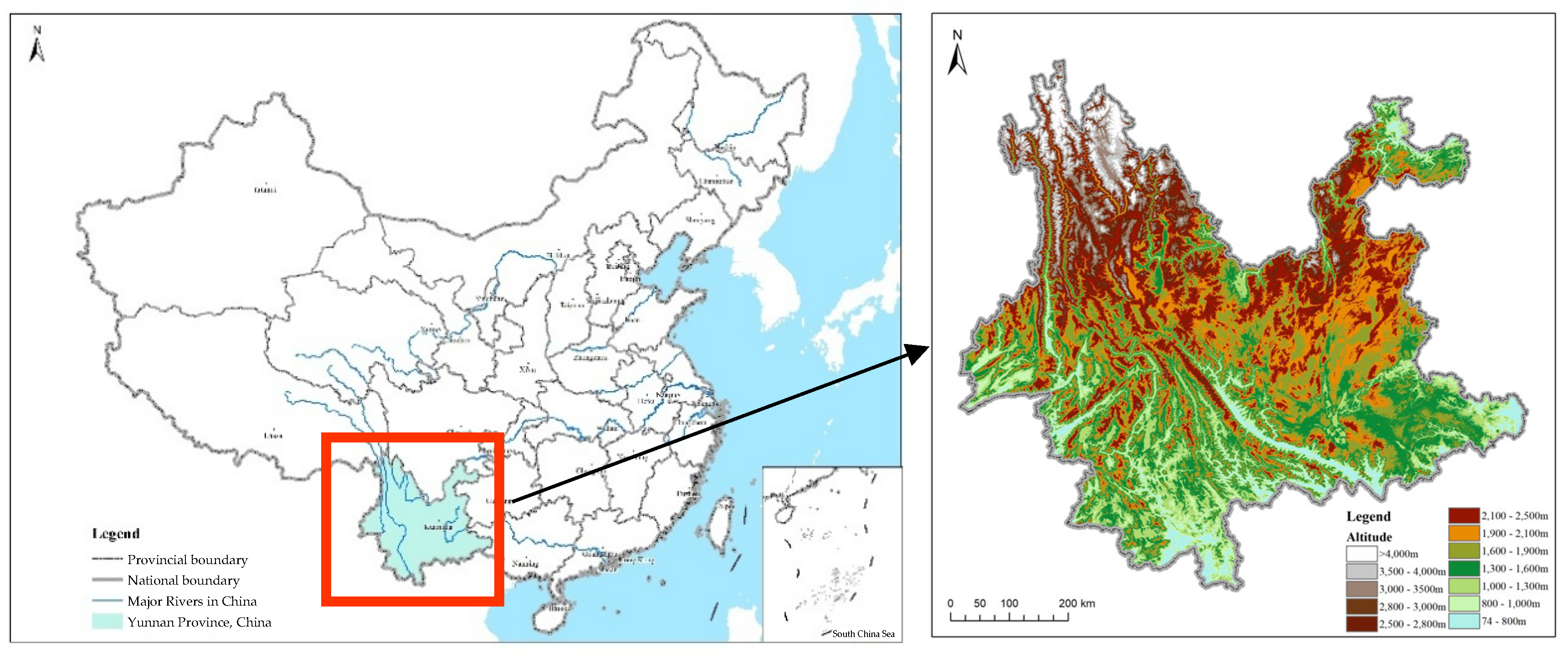
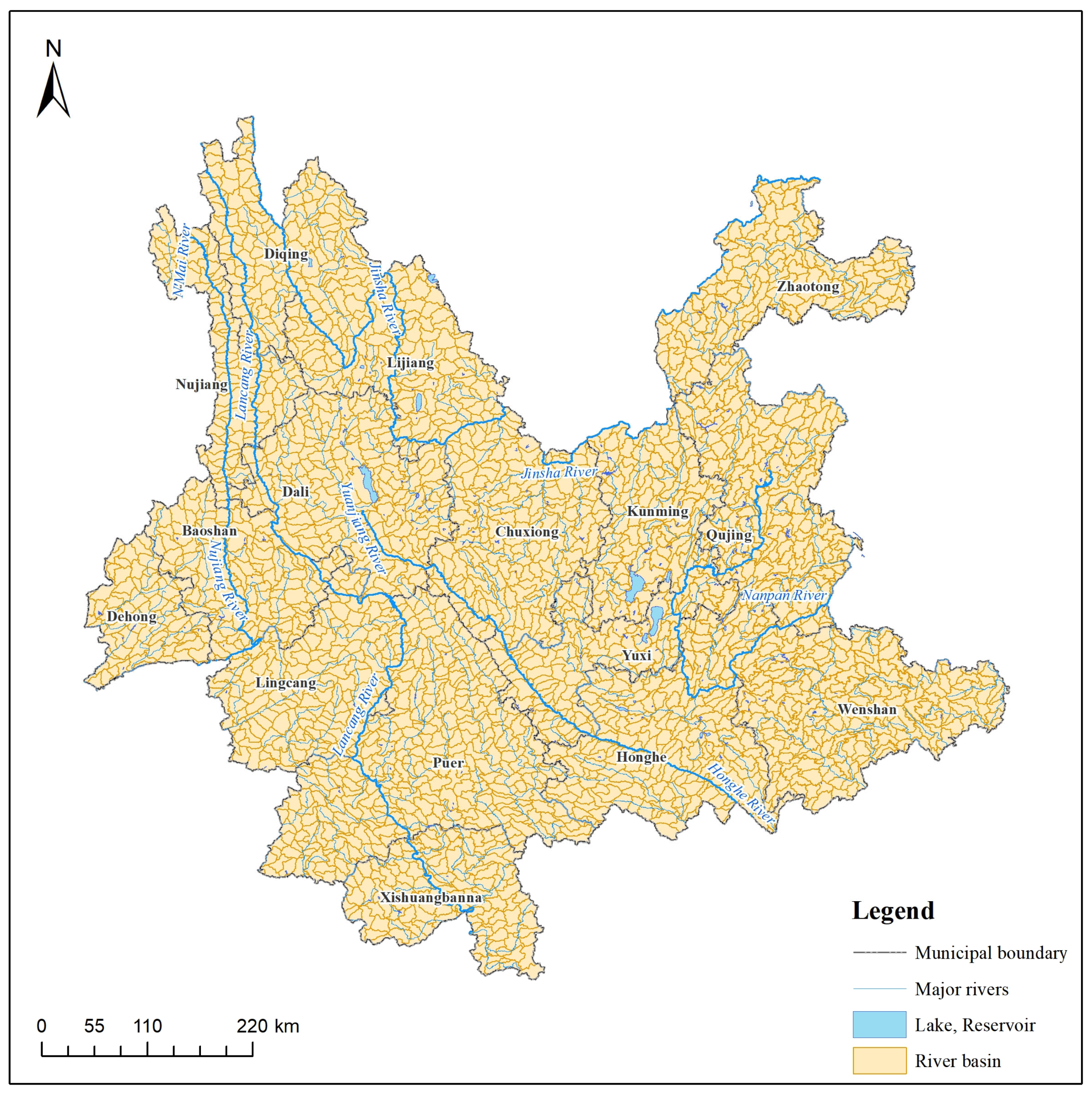
2.1. Study Area Overview

Yunnan Province is located on the southwest border of China, between 97°31’106°11’ E and 21°8’29°15’ N. The total area of Yunnan Province is 394,100 km2, with mountains, hills, and plateaus accounting for 94% of the province’s total area, and basins and valleys accounting for approximately 6% [24]. Yunnan Province is a typical mountainous province with significant mountain features [25] and many lakes and rivers (Figure 1). There are 908 rivers in the Yunnan Province with a runoff area of more than 100 km2. Most rivers are characterized by large drops, rapid flow, and significant variations in water flow. Regarding climate, the Qinghai–Tibet Plateau and the East Asian and South Asian monsoons have a significant influence, and precipitation is primarily concentrated from May to October.
Since the 1990s, global climate change has shown a warming trend. As a result, the frequency of heavy rain in Yunnan Province has increased [26]. Because of its unique geographical and climatic characteristics, Yunnan is a region where floods occur frequently. According to incomplete statistical data from 1990 to 2020, a total of 3648 counties in the province experienced flood disasters, with an average of approximately 118 counties (cities and districts) affected every year, with a total of 6439 deaths, and an average of 208 deaths per year. These floods caused the collapse of 875,500 houses and an average of 28,243 houses were damaged by floods every year. The direct economic losses caused by flood disasters are as high as 113,042 billion yuan (at current prices), with an average annual loss of 3.646 billion yuan, accounting for approximately 60% of the direct economic losses from natural disasters in the province [25].

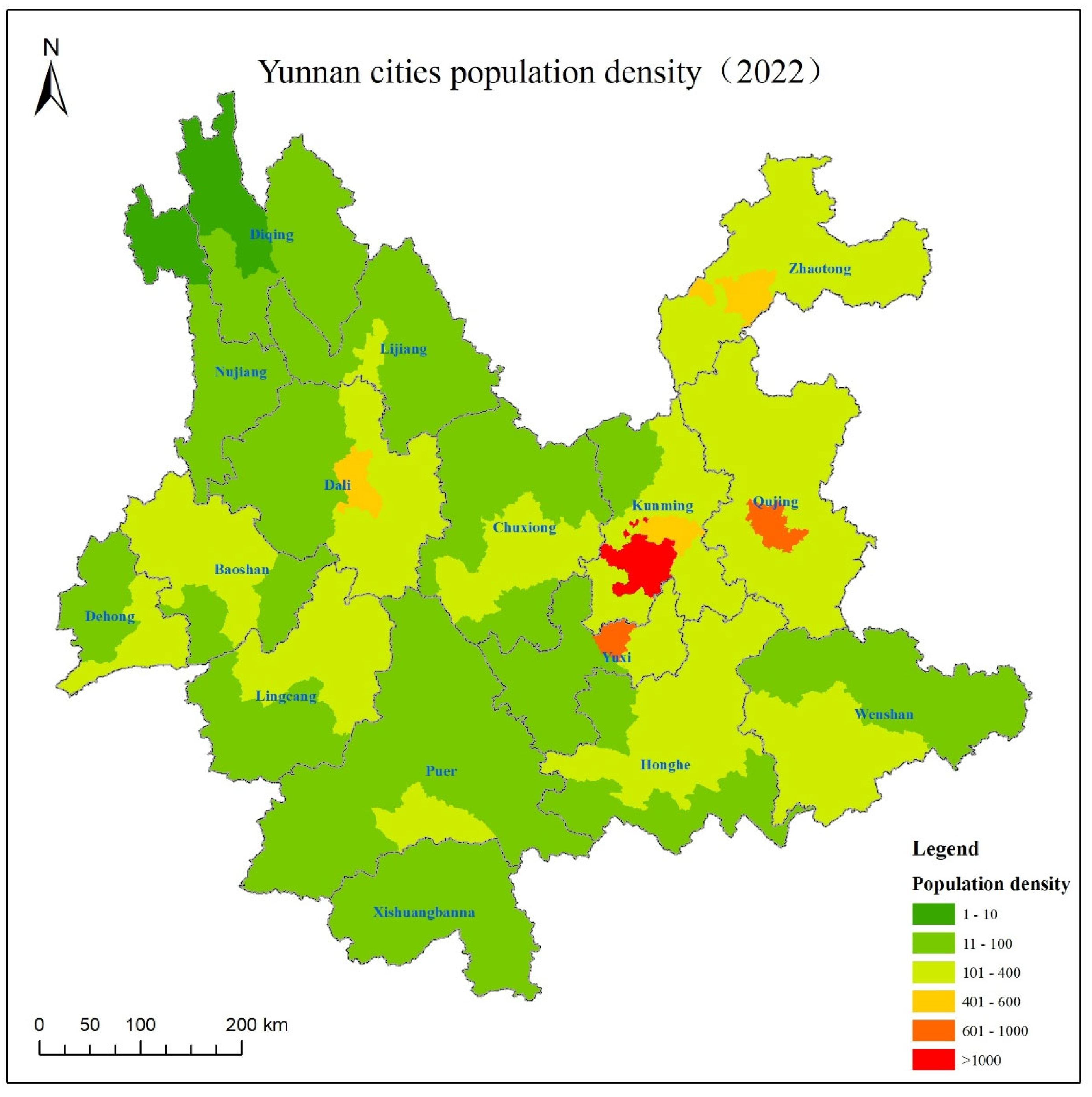
2.2. Data Source and Collation

The prevention and control division of the flash flood threat area takes the mountain river with a basin area below 3000 km2 as the object and divides the flash flood threat area into several sub-basin units according to the needs of flood risk analysis and calculation. According to the characteristics of the research object, the data selected in this study were primarily obtained from the results of the national survey and evaluation of flash flood disasters, including data on the populations affected by flash floods in each village, critical rainfall data of each village, and current flood control capacity data of the villages along the river. The watershed unit divisions were based on small watershed division data of approximately 200 km2 provided by the Yunnan Hydrology and Water Resources Bureau (Figure 2).

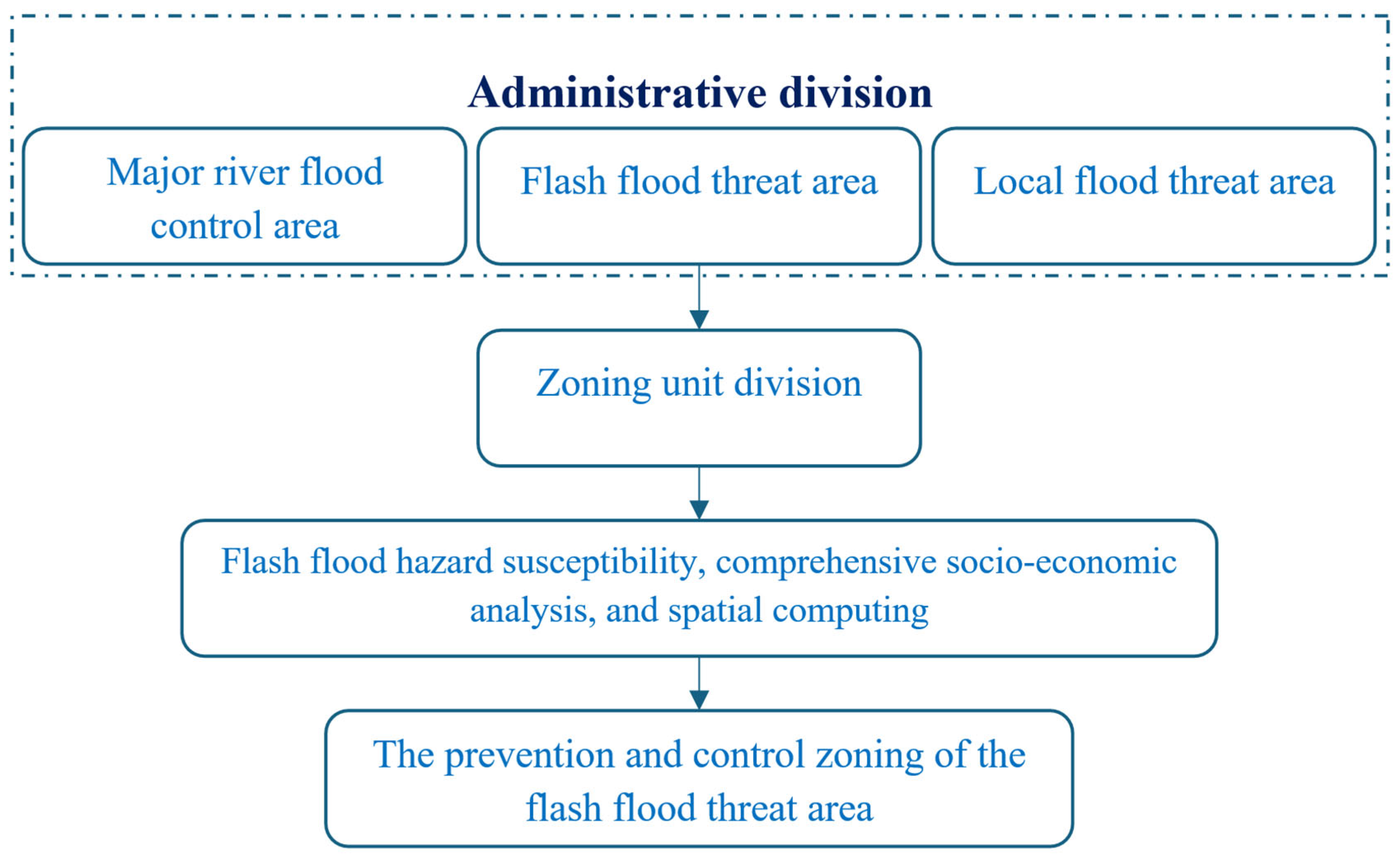
3. Technology Roadmap and Calculation Method

Technology Roadmap

The prevention and control zoning of flash flood threat areas is based on the collection and sorting of basic data that can be divided into three types: main river flood control zoning, flash flood threat areas, and local flood threat areas (Figure 3). In China, the main river flood control areas are primarily located in the middle and lower reaches of large rivers flowing into the sea and coastal areas. The terrain is predominately plain and basin, with a small part located in hills or mountains. The local flood threat areas include the Inner Mongolia Plateau, most areas of the Qinghai–Tibet Plateau, and most river areas in Northwest China, deserts, Gobi, and other areas. These areas have low population density, and even if there are floods in local areas, they will not cause disasters because of the sparse population; the flood threat is generally small. Flash flood threat area refers to mountains, hills, platforms, loess hilly tablelands, small river valley plains, small basins, and piedmont plains, which are likely to be affected by flash flooding, debris flow, and other disasters. For topographic and river distribution reasons, the distribution of major river flood control areas in Yunnan Province is small, and there is no local flood threat area. Therefore, the entire area of Yunnan was regarded as a flash flood threat area in this study. The control level of each watershed in the flash flood threat area was determined by referring to the population and critical rainfall affected by the flood, and the control division of the flash flood threat area was obtained.
In March 2021, the Ministry of Water Resources of the People’s Republic of China issued the “Technical requirements for the preparation of flood risk regionalization and prevention and control regionalization,” which indicates that the prevention and control regionalization of flash flood threat areas should refer to the results of the division of small watershed units in the national flash flood disaster investigation and evaluation project, and should conduct the prevention and control regionalization with a basin area of approximately 200 km2 as the unit. By making full use of the data of flash flood disaster prevention and control planning and flash flood disaster investigation and evaluation, the author sorted the population affected by flash floods (the population within the maximum possible inundation range or the population within the inundation range of a flash flood once in 100 years) and the critical rainfall of flash floods under general conditions of soil moisture. Based on the combination of rainstorm frequency and economic and social conditions, the small watershed was divided into key, medium, and general control zones (Table 1).
In this study, the population affected by flash flooding and the critical rainfall in the sub-watershed were selected as evaluation indices for the areas at risk of flash flood threat. In the “Technical requirements for the preparation of flood risk regionalization and prevention regionalization,” the population affected by flash flood prevention regionalization is divided into three judgment levels. Specifically, 200 km2 is used as the judgment unit. The first level is populations affected by flash floods being greater than or equal to 1000 people, and the second level is that the population affected by flash floods is 500–1000 people. If fewer than 500 people are affected by flash floods, they are classified as Level 3.
In the actual implementation process, the areas of small watersheds are often not the same. Focusing on this situation, the process of calculation in this study adopted the area-weighted method to differentiate different areas of a small watershed level affected by flash floods to eliminate the small watershed area of difference between the results of regionalization. To ensure that the population density in the small watershed was divided according to a standard method, the prevention and control of flood risk zoning and regionalization were compiled as technical requirements of the agreement. The specific methods used are as follows:
N 1 = A 200   k m 2 × 1000
N 2 = A 200   k m 2 × 500
where N1 and N2 are the reference indicators of the population affected by flash floods in small basins and A is the area of the small basins.
Using area weighting, the populations affected by flash floods in small catchments can be divided into three levels.
  • Level 1: N N 1
  • Level 2: N 2 N N 1
  • Level 3: N N 2
  • where n is the number of people affected by flash floods in the watershed. By comparing n with the calculated values of N1 and N2, the grade of the population affected by flash floods in the small watershed is determined.
In terms of the selection of another evaluation index and considering the analysis and calculation of the current flood control capacity of villages along the river in the results of the flash flood disaster analysis and evaluation, the frequency of flood peak discharge corresponding to the disaster water level of disaster prevention objects and the cumulative population and house number under the designed flood water level of each frequency were fully considered. This is a more comprehensive index compared with the frequency corresponding to the critical rainfall. Therefore, we chose the status quo of flood control ability as the judgment index that was calculated. According to the current flood control capacity and the population affected by flash floods, a small watershed is divided into key control zoning, medium control zoning, and general control zoning (Table 2).
In the process of sorting the data of the two types of indicators, the following principles were followed. If multiple flood-threatened villages are distributed in a watershed, the current flood prevention ability of the small watershed would be the lowest. In terms of the population indicators affected by the flash flood, the number of people affected by the flash flood in the small watershed was the sum of all villages affected by the flash flood in the small watershed. After screening and merging, the decision data for each small watershed were determined. If there was no village distribution in a basin, this meant that the village in the basin has the ability to prevent a 100-year return period flood; therefore, when determining the zoning level, it was uniformly determined as the general prevention and control zoning of flash floods.

4. Results Analysis

4.1. Summary of Decision Factors

Yunnan Province has jurisdiction over 16 prefecture-level administrative regions. Through the collection and sorting of the results of the investigation and evaluation of flash flood disasters in Yunnan Province, we obtained data such as the population affected by flash floods (extremely dangerous areas, high-risk areas, and dangerous areas), critical rainfall, and the current flood control capacity of villages in Yunnan Province. The data included 11,548 river villages, of which only 1808 had a flood control capacity of once in a 100-year return period. There were 4461 villages with flood control capacity over a 20-year return period but less than a 100-year return period. Furthermore, 5279 villages were found to have a flood control capacity of less than a 20-year return period, with 1463 having a flood control capacity of less than a 5-year return period. Table 3 lists the proportions of villages with different flood control capacities.
The number of residents in the flash flood hazard areas is another important indicator. The data indicate that 337,359 people settled in the flash flood risk areas in Yunnan Province, including 68,187 people in the highest-risk area (flood control capacity < 5-year return period), 117,831 people in the high-risk area (5-year return period < flood control capacity < 20-year return period), and 151,341 people in the dangerous areas (20-year return period < flood control capacity < 100-year return period). Table 4 lists the population affected by flash floods in each city of Yunnan.
Subsequently, we used ArcGIS 10.2 software to spatially correlate 11,548 villages along the river with 2193 small watersheds to determine the actual flood control capacity of each watershed and the population in areas made hazardous by flash floods. The results revealed that all the villages were distributed in 1639 small watersheds, and the remaining 554 small watersheds without village distribution were uniformly classified as the general prevention and control zoning of flash flood disaster; the size of this area is 81,209.80 km2. Among the small watersheds with village distribution, there were 658 that contained villages with a flood control capacity of less than a 5-year return period. There were also 981 small watersheds containing villages with a flood control capacity higher than the 5-year return period but lower than the 100-year return period; of these, 532 small watersheds contained villages with flood control capacity higher than the 5-year return period but lower than the 20-year return period. The remaining 449 small watersheds contained villages with flood control capacity higher than the 20-year return period but lower than the 100-year return period. These small watershed levels of the flash flood prevention division had to be combined in the judgment area population.

4.2. Analysis of Calculation Results

Figure 4 and Table 5 show the calculation results and distribution of the prevention and control zones of flash flood threat areas in Yunnan Province. The calculation results were analyzed as follows.

4.2.1. Key Prevention and Controlled Zoning for Flash Floods

According to the criteria in Table 2, we analyzed the flood control capacity and population size of the small watershed. The results disclosed that 160 small watersheds were classified as key areas for flash flood control and were primarily distributed in Dehong, Kunming, Wenshan, Yuxi, Zhaotong, and other locations, with a total area of 29,549.35 km2.
In Yunnan, the largest key flash flood prevention and control zone is Kunming, with a total of 6473.78 km2 of the key prevention and controlled zoning for flash floods, accounting for 32.81% of the city’s administrative division area. Kunming is the capital of Yunnan Province, the central city of the Urban Agglomeration in Central Yunnan, the most populous city in Yunnan [27] and a large city in China. Combined with Table 4, it is evident that the number of people affected by flash floods in the highest danger zones of Kunming is the largest in Yunnan, which is the main reason for the large area of key prevention and controlled zoning for flash floods in Kunming. Figure 5 shows the population density of each city in Yunnan.
The areas designated as key flash flood prevention and control zones in Dehong, Yuxi, and Zhaotong also accounted for more than 20% of the administrative areas of these cities. Previous studies confirmed that most rural residents in Yuxi live in areas below steep slopes and near streams [28]. During periods of relatively concentrated and heavy rainfall, there is a significant threat of landslides and flash floods. Based on the data analysis in Table 4, Yuxi has the third largest population in the highest danger zone and the largest population in the high-risk zone in Yunnan. Of the flash flood prevention and control villages in Yuxi, 70% have a current flood prevention capacity below the 20-year return period. Therefore, the key prevention and control zoning for flash floods in Yuxi is relatively large.
Dehong is located to the south of the Hengduan Mountains and to the west of the Gaoligong Mountains. The terrain is high and steep in the northeast and low, wide, and gentle in the southwest [29]. The terrain is predominately mountainous, with only scattered river valleys and plains among the mountains. The highest point is Dannang Mountain in the north of Yingjiang County, with an altitude of 3404.6 m. The lowest point is in the Jieyang River Valley in the west of Yingjiang County, with an altitude of 210 m and a relative height difference of 3194.6 m. The entire area within the jurisdiction experiences intense neotectonic movement, providing favorable material conditions for the development of flash floods, debris flows, and landslides [30]. The topographic conditions are extremely conducive to the development and strengthening of precipitation cloud systems, and heavy precipitation is prone to occur. When jointly analyzing Table 3 and Table 4, it can be seen that the proportion of villages in Dehong with a flood control capacity below the 20-year return period is as high as 78%, and 42% of the analyzed villages have a current flood control capacity below the 5-year return period, which is a reason why the key prevention and control zones for flash floods in Dehong are relatively large.
Zhaotong is located in the transition zone from the Sichuan Basin to the Yunnan–Guizhou Plateau, where the terrain, geology, and geomorphology are complex, with steep slopes and fast-flowing rivers [31]. Mountainous areas account for 96% of the total area. Between 2006 and 2016, ten flash flood disasters killed at least five people in Zhaotong, an area prone to frequent flash flood disasters. Combining Table 3 and Table 4 indicates that Zhaotong has a relatively large number of villages that are vulnerable to flash floods, and the population in danger areas is also relatively large. Therefore, the area of key prevention and control measures for flash floods is relatively big.

4.2.2. Medium Prevention and Controlled Zoning for Flash Floods

The medium prevention and control zone for flash floods includes a total of 590 small watersheds, totaling 108,271.52 km2. Among them, the medium prevention and control zones for flash floods in Kunming, Nujiang, and Xishuangbanna accounted for more than 40% of their respective planning areas, whereas the medium prevention and control zones in Chuxiong, Diqing, Pu’er, Yuxi, and Zhaotong accounted for more than 30% of their respective administrative areas. According to the analysis in Table 3, 60.19%, 66.12%, and 60.44% of the flash flood prevention and control villages in Diqing, Nujiang, and Xishuangbanna, respectively, had less flood prevention and control capacity than the 20-year return period. The results in Table 4 illustrate that the populations of the flash flood-dangerous areas in Diqing, Nujiang, and Xishuangbanna rank 16th, 14th, and 12th in Yunnan, respectively, and the population in the at-risk areas is relatively small. However, the results in Table 3 demonstrate that among the analyzed and evaluated villages in Diqing, Nujiang, and Xishuangbanna, 60.19%, 66.12%, and 60.44% of the flash flood prevention and control villages had a current flood control capacity of less than once in 20 years, respectively. The sum of these two factors increased the area of the medium control zones in these three cities.
Among the flash flood disaster prevention villages in Chuxiong, the proportion of villages with flood control abilities below the 20-year return period was 48.01% and the population in the flash flood danger area ranked eighth among all cities in Yunnan. A city with a similar situation to Chuxiong is Pu’er, where the number of villages with flood control capacity below the 20-year return period was 42.53% and the population in the flash flood danger area ranked 10th among all cities in Yunnan. Under the combined effect of the village flood control capacity and the number of people in the flash flood danger area, the area of medium prevention and control zoning in these two cities is relatively large.

4.2.3. General Prevention and Control Zoning for Flash Floods

The general prevention and control zoning for flash floods includes a total of 1443 small watersheds, with a total area of 239,413.68 km2, accounting for 63.47% of the total area of the Yunnan administrative division. Among these small watersheds, there are 889 small watersheds with flash flood prevention and control villages and a total area of 158,203.89 km2. From the perspective of spatial distribution, among the 16 cities under the jurisdiction of Yunnan, general prevention and control zoning for flash floods in 10 cities accounted for more than 60% of the administrative area, and general prevention and control zoning for flash floods in five cities accounted for more than 70%. This is because the flash flood control capacity of the villages along the river in most cities is higher than the 20-year return period and the population in the flash flood danger area is relatively small; therefore, the general prevention and control zoning in the flash flood is larger.

5. Conclusions

Taking Yunnan as an example, this study investigated the prevention and control of flash floods in mountainous cities. In the research, we utilized the data from investigations and evaluations of flash flood disasters. The adopted method can rapidly iterate the results of the prevention and control zoning, along with updating the results. Before the flood season arrives each year, the flood control department could focus on investigating and rechecking the number of people affected by flash floods in high-risk and medium-risk river basins, update the results of the prevention and control zoning in a timely manner, and clarify the key points of flood control work. For example, under the current data conditions, the results show that 8% of the land area in Yunnan is a key flash flood prevention and control zone, and 29% is a medium flash flood prevention and control zone. These areas are predominately distributed in the central and northeastern regions of Yunnan, and the main cities involved are Dehong, Kunming, Yuxi, and Zhaotong. The combined area of key and medium prevention and control zoning for flash floods in these four cities exceeded 50% of the urban administrative area. Key flood control and hydrological monitoring should be carried out in these cities during the flood season, such as checking and removing water obstructions in river channels in advance, and ensuring that rainfall monitoring equipment can operate normally. For villages with flood control levels lower than the five-year recurrence period, the flood control level of villages along rivers should be enhanced as a priority. If necessary, residents can be organized to evacuate in advance based on the forecast of precipitation.
In December 2023, the Ministry of Water Resources of the People’s Republic of China promulgated technical requirements for a supplementary survey and evaluation of flash flood disasters, which indicates that the results of flash flood disaster investigations and evaluations are constantly updated and improved. The research method adopted in this study can be used to constantly update the prevention and control zoning for flash floods according to the results of flash flood disaster investigation and evaluation while also providing a reference for flash flood disaster prevention and control in mountain cities in the context of accelerating urbanization.

Author Contributions

Conceptualization, Z.Z. and Q.L.; methodology, C.L.; software, Z.Z.; validation, Q.L.; formal analysis, Z.Z.; investigation, Q.L.; resources, Y.C.; data curation, Y.C.; writing—original draft preparation, Z.Z.; writing—review and editing, Z.Z. and Q.L.; supervision, C.L.; project administration, Y.C. All authors have read and agreed to the published version of the manuscript.

Funding

This research was supported by the National Key R&D Program of China (2023YFC3006705).

Institutional Review Board Statement

Not applicable.

Informed Consent Statement

Not applicable.

Data Availability Statement

The original contributions presented in this study are included in the article. Further inquiries can be directed to the corresponding author.

Conflicts of Interest

The authors declare no conflicts of interest.

References

  1. Liu, Y. Study on Spatiotemporal Distribution and Heterogeneity of Driving Forces of Flash Flood in China. Ph.D. Thesis, Tianjin University, Tianjin China, 2017. [Google Scholar]
  2. Sun, D.; Zhang, D.; Cheng, X. Framework of National Non-structural Measures for Flash Flood Disaster Prevention in China. Water 2012, 4, 272–282. [Google Scholar] [CrossRef]
  3. Camorani, G.; Castellarin, A.; Brath, A. Effects of Land-use Changes on the Hydrologic Response of Reclamation Systems. Phys. Chem. Earth 2005, 30, 561–574. [Google Scholar] [CrossRef]
  4. Guoyi, L.I.; Jiahong, L.; Weiwei, S. Urban Flood Risk Assessment Under Rapid Urbanization in Zhengzhou City, China. Reg. Sustain. 2023, 4, 332–348. [Google Scholar] [CrossRef]
  5. Dawei, Z.; Quan, J.; Zhang, H.; Wang, F.; Wang, H.; He, X. Flash Flood Hazard Mapping: A Pilot Case Study in Xiapu River Basin. Water Sci. Eng. 2015, 8, 195–204. [Google Scholar] [CrossRef]
  6. Qiu, H.; Hu, B.; Zhang, Z. Impacts of Land Use Change on Ecosystem Service Value Based on SDGs Report--Taking Guangxi as an Example. Ecol. Indic. 2021, 133, 108366. [Google Scholar] [CrossRef]
  7. Li, Y.; Weimin, Y.E.; Shaoxuan, D. Lessons Africa Can Learn from China’s Experience in Urbanization. Int. Relat. Dipl. 2023, 11, 125–134. [Google Scholar] [CrossRef]
  8. Farrell, K.; Westlund, H. China's Rapid Urban Ascent: An Examination Into the Components of Urban Growth. Asian Geogr. 2018, 35, 85–106. [Google Scholar] [CrossRef]
  9. Sharma, A.; Poonia, M.; Rai, A.; Biniwale, R.B.; Tiwari, A.; Lachure, S.; Tuegel, F.; Holzbecher, E.; Hinkelmann, R. Impact of Land Use and Rainfall Change on Runoff and Flood Resilience of an Urban Environment: A Case Study of Chennai City, India. Arab. J. Geosci. 2024, 7, 17. [Google Scholar] [CrossRef]
  10. Li, H.; Wang, Y.; Ping, L.; Li, N.; Zhao, P. Comprehensive Zoning Strategies for Flood Disasters in China. Water 2024, 16, 2546. [Google Scholar] [CrossRef]
  11. Fang, C. Study on Spatial Pattern of China Mountainous cities—Morden and Contemporary Part. Master’s Thesis, Chongqing University, Chongqing, China, 2015. [Google Scholar]
  12. Zhang, Z.; Li, Q.; Liu, C.; Ding, L.; Ma, Q.; Chen, Y. Driving Effects and Spatial-Temporal Variations in Economic Losses Due to Flood Disasters in China. Water 2022, 14, 2266. [Google Scholar] [CrossRef]
  13. NOAA/NWS. Flash Flood Guidance Improvement Team; National Weather Service Final Report; National Weather Service: Washington, DC, USA, 2003.
  14. Islam, M.M.; Ujiie, K.; Noguchi, R.; Ahamed, T. Flash Flood-induced Vulnerability and Need Assessment of Wetlands Using Remote Sensing, GIS, and Econometric Models. Remote Sens. Appl. Soc. Environ. 2022, 25, 100692. [Google Scholar] [CrossRef]
  15. Knocke, E.T.; Kolivras, K.N. Flash Flood Awareness in Southwest Virginia. Risk Anal. 2010, 27, 155–169. [Google Scholar] [CrossRef] [PubMed]
  16. Liu, C.; Guo, L.; Ye, L.; Zhang, S.; Song, T. A Review of Advances in China’s Flash Flood Early-warning System. Nat. Hazards 2018, 92, 619–634. [Google Scholar] [CrossRef]
  17. Ren, H.; Zhang, P.; Yang, Q.; Hu, W. Theory and Practice on Areas Division of Mountain Flood Prevention in China. Chin. Water Resour. 2005, 14, 17–20. [Google Scholar]
  18. Ma, J.; Zhang, P.; Ren, H. The Study on the Method of Chinese Mountain Torrents Disaster Prevention Regionalization. Chin. Water Resour. 2007, 14, 21–24. [Google Scholar]
  19. Wang, X.; Yue, L.; Yuwei, H. Study of Regionalization of Flash Flood Prevention Based on GIS Index Model. Water Resour. Power 2011, 29, 54–57. [Google Scholar]
  20. Wang, N.; Lombardo, L.; Tonini, M.; Cheng, W.; Guo, L.; Xiong, J. Spatiotemporal Clustering of Flash Floods in a Changing Climate (China, 1950–2015). Nat. Hazards Earth Syst. Sci. 2021, 21, 2109–2124. [Google Scholar] [CrossRef]
  21. Li, C.; Guo, L.; Liu, C.; Sun, D. Preliminary Studies on Mountain Flood Disaster Evaluation. Chin. Water Resour. 2014, 18, 14–17. [Google Scholar]
  22. Zhang, X.; Li, C.; Sun, D. Research on National Flash Flood Disasters Risk Zoning Based on Survey and Evaluation of Big Data. Chin. Flood Drought Manag. 2020, 30, 61–63. (In Chinese) [Google Scholar]
  23. Yuan, J. Study on the Influence of Urbanization on Flood Characteristics of Small and Medium Rivers in Mountain Area. Master’s Thesis, Chongqing Jiaotong University, Chongqing, China, 2017. [Google Scholar]
  24. Wang, D.; Yuan, S.; Yang, C.; Zhu, X.; Luo, L. Investigation and Evaluation of Flash Flood Disasters in Yunnan Province. Chin. Flood Drought Manag. 2018, 28, 40–43,47. [Google Scholar] [CrossRef]
  25. Wang, M.; Wu, Y.; Hu, P. Study on Spatial and Temporal Patterns of Land Use in Mountainous Areas of Yunnan Province from Perspective of Terrain Gradient. Acta Agric. Jiangxi 2020, 32, 123–131. [Google Scholar] [CrossRef]
  26. Cheng, J.; Xie, M. The Analysis of Regional Climate Change Features over Yunnan in Recent 50 Years. Prog. Geogr. 2008, 27, 19–26. [Google Scholar]
  27. Yu, H.; Yingmei, W.; Chen, L.; Min, W.; Yan, Z. Spatial and Temporal Evolution and Multi-scenario Modeling of Land Use and Habitat Quality in Highland Mountainous Urban Agglomeration of Central Yunnan, Southwest China. Chin. J. Appl. Ecol. 2024, 35, 2842. [Google Scholar] [CrossRef]
  28. Hu, J.; Xu, G.; Wang, Y. Characteristic of Mountain Torrents and its Vulnerability Zoning in Yuxi City. J. Eng. Geol. 2006, 14, 213–218. [Google Scholar]
  29. Tao, Y.; Tang, C.; Cun, C.Q.; Yang, X.D. The Meteorological Causes for Flash Flood and Debris Flow on July 5, 2004 in Dehong Prefecture of Yunnan Province. Mt. Res. 2005, 23, 53–62. [Google Scholar]
  30. Gao, K.C.; Meng, G.C.; Wei, F.Q. Analysis and Counter-Measure for the Large-Scale Landslide-Debris Flow Hazard in Dehong, Yunnan, China. J. Disaster Prev. Mitigat Eng. 2005, 25, 251–257. [Google Scholar]
  31. Dongsheng, W.; Shutang, Y.; Liyan, L. Analysis of Causes and Countermeasures of ‘2016.7.5’ Flash Flood Disaster in Zhaotong City, Yunnan Province. Chin. Flood Drought Manag. 2019, 29, 5–10. [Google Scholar] [CrossRef]
Figure 1. Location of the study area.
Applsci 15 04781 g001
Figure 2. River basin of Yunnan province distribution.
Applsci 15 04781 g002
Figure 3. Technical flow chart of prevention and control zoning of a flash flood threat area.
Applsci 15 04781 g003
Figure 4. The prevention and control zoning of flash flood threat areas in Yunnan.
Applsci 15 04781 g004
Figure 5. Distribution of population density in Yunnan.
Applsci 15 04781 g005
Table 1. Standard for the prevention and controlled zoning for flash floods.
Socio-economic status
The designed rainfall frequency corresponding to the critical rainfall
More than 1000 people were affected by the flash floods or the national and provincial important infrastructure and industrial and mining enterprises are seriously affected by flash floods.More than 500 people were affected by the flash floods or the prefecture-level important infrastructure and industrial and mining enterprises are seriously affected by flash floods.Less than 500 people were affected by the flash floods, and no important infrastructure or industrial and mining enterprises were affected by flash floods.
The critical rainfall ≤ designed rainfall p = 20%key prevention and controlled zoning for flash floodskey prevention and controlled zoning for flash floodsmedium prevention and controlled zoning for flash floods
Designed rainfall p = 5% ≥ The critical rainfall > designed rainfall p = 20%key prevention and controlled zoning for flash floodsmedium prevention and controlled zoning for flash floodsgeneral prevention and control zoning for flash floods
The critical rainfall > designed rainfall p = 5%medium prevention and controlled zoning for flash floodsgeneral prevention and controlled zoning for flash floodsgeneral prevention and controlled zoning for flash floods
Table 2. The standards for the prevention and controlled zoning for flash flooding in this study.
Level of Population Threatened by Flash Floods
Flood Control Capacity
N N 1 N 2 N N 1 N N 2
Less than once in a 5-year return periodkey prevention and controlled zoning for flash floodskey prevention and controlled zoning for flash floodsmedium prevention and controlled zoning for flash floods
More than once in a 5-year return period but less than once in a 20-year return periodkey prevention and controlled zoning for flash floodsmedium prevention and controlled zoning for flash floodsgeneral prevention and controlled zoning for flash floods
More than once in a 20-year return periodmedium prevention and controlled zoning for flash floodsgeneral prevention and controlled zoning for flash floodsgeneral prevention and controlled zoning for flash floods
Table 3. Flood control capacity of villages along rivers in Yunnan.
City NameBelow the 5-Year Return PeriodHigher Than the 5-Year Return Period and Below the 20-Year Return PeriodHigher Than the 20-Year Return Period and Below the 100-Year Return PeriodHigher Than the 100-Year Return PeriodTotal
Kunming307 (28.64%)307 (28.64%)160 (14.93%)298 (27.80%)1072
Qujing26 (2.89%)237 (26.33%)419 (46.56%)218 (24.22%)900
Yuxi92 (13.43%)392 (57.23%)201 (29.34%)0 (0%)685
Baoshan12 (2.15%)115 (20.57%)243 (43.47%)189 (33.81%)559
Zhaotong202 (16.22%)496 (39.84%)489 (39.28%)58 (4.66%)1245
Lijiang56 (9.84%)190 (33.39%)204 (35.85%)119 (20.91%)569
Puer132 (19.50%)193 (28.51%)331 (48.89%)21 (3.10%)677
Lingcang17 (4.08%)97 (23.26%)280 (67.15%)23 (5.52%)417
Chuxiong105 (12.17%)262 (30.36%)335 (38.82%)161 (18.66%)863
Honghe40 (3.93%)343 (33.69%)524 (51.47%)111 (10.90%)1018
Wenshan89 (10.19%)183 (20.96%)343 (39.29%)258 (29.55%)873
Xishuangbanna93 (30.59%)108 (35.53%)83 (27.30%)20 (6.58%)304
Dali59 (4.21%)480 (34.21%)634 (45.19%)230 (16.39%)1403
Dehong154 (42.08%)132 (36.07%)43 (11.75%)37 (10.11%)366
Nujiang2 (0.73%)163 (59.71%)43 (15.75%)65 (23.81%)273
Diqing77 (23.77%)118 (36.42%)129 (39.81%)0 (0%)324
Total1463 (12.67%)3816 (33.04%)4461 (38.63%)1808 (15.66%)11,548
Table 4. Population affected by flash floods in each city of Yunnan.
City NameHighest-Risk AreaHigh-Risk AreaDangerous AreasTotal
Kunming26,871 (37.39%)21,842 (30.39%)23,149 (32.21%)71,862
Qujing261 (1.02%)8585 (33.71%)16,623 (65.27%)25,469
Yuxi5802 (15.65%)23,738 (64.04%)7526 (20.30%)37,066
Baoshan122 (1.33%)1423 (15.48%)7647 (83.19%)9192
Zhaotong2814 (6.20%)12,515 (27.59%)30,036 (66.21%)45,365
Lijiang895 (6.20%)5231 (36.22%)8318 (57.59%)14,444
Puer5210 (40.09%)3148 (24.22%)4638 (35.69%)12,996
Lingcang112 (2.96%)859 (22.70%)2813 (74.34%)3784
Chuxiong1444 (9.56%)6186 (40.97%)7470 (49.47%)15,100
Honghe283 (2.24%)4434 (35.15%)7898 (62.61%)12,615
Wenshan1123 (6.12%)7085 (38.63%)10,134 (55.25%)18,342
Xishuangbanna3196 (26.40%)3438 (28.39%)5474 (45.21%)12,108
Dali1149 (4.56%)10,381 (41.18%)13,678 (54.26%)25,208
Dehong16,962 (64.56%)5625 (21.41%)3688 (14.04%)26,275
Nujiang5 (0.11%)2478 (56.78%)1881 (43.10%)4364
Diqing1938 (61.15%)863 (27.23%)368 (11.61%)3169
Total68,187 (20.21%)117,831 (34.93%)151,341 (44.86%)337,359
Table 5. Distribution of prevention and control zoning of flash flood threat areas in each city of Yunnan (km2).
City NameKey Prevention and Controlled ZoningMedium Prevention and Controlled ZoningGeneral Prevention and Control ZoningTotal
Kunming6473.787998.695259.1419,731.61
Qujing764.843791.8914,193.0218,749.76
Yuxi899.909009.2418,169.5828,078.72
Baoshan863.176730.1820,090.1327,683.47
Zhaotong2649.733875.164129.4410,654.32
Lijiang53.307802.3615,172.3423,028.00
Puer970.116335.2024,687.9331,993.24
Lingcang957.193955.3715,315.5820,228.14
Chuxiong447.294257.8618,667.5623,372.70
Honghe588.335948.417964.4814,501.22
Wenshan842.4613,872.6928,945.0043,660.15
Xishuangbanna1644.617805.8019,158.1328,608.54
Dali2388.717126.9421,966.5131,482.15
Dehong1549.367649.209588.5318,787.09
Nujiang3745.604637.116030.2514,412.97
Diqing4710.997475.4310,076.0522,262.48
Total29,549.35108,271.52239,413.68377,234.56
Disclaimer/Publisher’s Note: The statements, opinions and data contained in all publications are solely those of the individual author(s) and contributor(s) and not of MDPI and/or the editor(s). MDPI and/or the editor(s) disclaim responsibility for any injury to people or property resulting from any ideas, methods, instructions or products referred to in the content.

