4.1. Satellite Data for Coastal Monitoring
Both the Sentinel and Landsat missions serve complementary functions in shoreline surveillance, each superior in different temporal and spatial regimes. Sentinel-2 has high resolution (10 m) and 5-day revisits, making it very effective for detecting relatively short-term shoreline changes related to storms, tidal action, or human activities, with near-real-time coastal hazard information [
47]. Its shorter temporal record since 2015, however, hinders it in the analysis of long-term trends.
On the other hand, Landsat satellites provide a four-decade record of observation beginning in 1972, which is extremely useful for the analysis of long-term coastal trends like gradual sea level rise or sediment re-allocation [
20,
51]. Though its 30 m spatial resolution and recurring 16-day visitation may overlook finer-scale events, Landsat is an anchor resource for historical shoreline analysis [
19].
Furthermore, the Synthetic Aperture Radar (SAR) mission, Sentinel-1, provides monitoring in environments where optical sensors are inadequate such as under cloud cover, during night-time imaging, or in sediment-charged waters [
55,
69]. SAR can monitor changes in surface roughness, suitable for identifying land–water interfaces even in adverse environments [
81]. Though it has poorer spatial resolution and less ability to discriminate close surfaces such as wet sand and shallow water, Sentinel-1 is especially useful in monsoon-hit or tropical environments [
82,
83].
Studies like those of Arjasakusuma et al. (2021), Spinosa et al. (2021), and Zollini et al. (2023) [
35,
39,
55] indicate the efficiency of Sentinel-1 SAR, either used individually or combined with optical data, in providing improved accuracy in shoreline mapping. These studies verify the efficacy of the combination of SAR and optical data in compensating for inherent weaknesses in either dataset to provide consistent monitoring regardless of different environmental scenarios.
Table 4 compared major studies using Sentinel-1 SAR for shoreline detection and change detection based on the review content of the selected studies.
Sentinel–Landsat Synergy in Shoreline Monitoring
A synergistic combination of both missions, for the monitoring of short-term processes with Sentinel and long-term trends with Landsat, presents the most authoritative coverage for coastal research.
The fusion of Sentinel-2 and Landsat imagery has emerged as a powerful strategy for monitoring coastal dynamics by combining the high spatial and temporal resolution of Sentinel-2 with the long historical archive of Landsat, as our review identified in the selected studies [
43,
47,
69,
84].
This synergy enables improved shoreline detection and change analysis across both short- and long-term timeframes. Image enhancement [
46] and temporal harmonization enhanced with AI learning-powered super-resolution methods have been utilized to combine the merits of the two datasets [
85]. Such methods enable more uniform shoreline extraction in areas of poor coverage due to frequent cloud coverage or seasonality, where optical imagery is inadequate on its own, such as temporal gap-filling with Landsat data, which has effectively assisted in increasing scene continuity in scenarios where Sentinel-2 imagery is partially hindered. Deep learning models, especially those that are dependent on Convolutional Neural Networks (CNNs), have better classification accuracy and maintain the spectral integrity of the fused products [
20,
21,
86].
The effectiveness of this combined approach emerged through recent research. Quang et al. [
11] used the DSAS on stacked Sentinel–Landsat data to virtually monitor 30 years of shoreline evolution along the Da Nang coast in Vietnam. Their fusion analysis allowed for an improvement in temporal resolution, as well as the clear detection of erosion and accretion trends. In the same vein, Hossen and Sultana [
41] carried out research on Sandwip Island, India, using Landsat (1988–2022) combined with Sentinel-2 imagery within the framework of DSAS-GIS. Their findings permitted the quantification of decadal shoreline changes while also estimating the mean rates of change, showing the capability of the fusion for effective long-term monitoring in dynamic delta settings.
Machine learning is also at the forefront of extending the benefits of fused data. McAllister et al. [
21] applied Sentinel-2 imagery fused with supervised classifiers for shoreline proxy delineation in several coastal settings. Their approach showed high accuracy in classification, affirming spectral fusion’s use in facilitating automated shoreline extraction. Also, Zollini et al. [
55] suggested semi-automatic shoreline extraction with the fusion of Sentinel-1 SAR with optical data for Sentinel-2. The use of the J-Net Dynamic algorithm considerably enhanced detection performance in the presence of artificial features, as well as varying shoreline complexity, especially where optical-only methods could not perform as expected.
At broader scales, Taveneau et al. [
34] combined Sentinel-2 and Landsat imagery in order to observe coastal erosion on Senegal’s Langue de Barbarie. Combining historical and modern-day satellite imagery made it possible to map significant shoreline displacement due to anthropogenic disturbances and sea-level rise. Similarly, Arjasakusuma et al. [
35] combined Landsat, Sentinel-2, and ancillary data in order to map long-term shoreline retreat due to coastal degradation and subsidence on the northern coast of Java in Indonesia.
Together, these studies highlight the efficacy of Sentinel–Landsat synergy in facilitating coastal monitoring activities [
18]. The combined datasets enhance the spatial resolution without compromising historical depth for vigorous trend analysis. Not only is this union instrumental in increasing the accuracy of shoreline detection under varying environmental circumstances, but it is also an adaptable and open-access solution for coastal area management. As illustrated in the literature surveyed, multi-sensor fusion is useful for both retrospective analysis and near-real-time applications, making it invaluable for climate adaptation, spatial planning, and evidence-based decision-making for vulnerable coastal areas. Complementing each other, Sentinel’s temporal frequency and Landsat’s temporal extent ensure an excellent foundation for shoreline monitoring [
51].
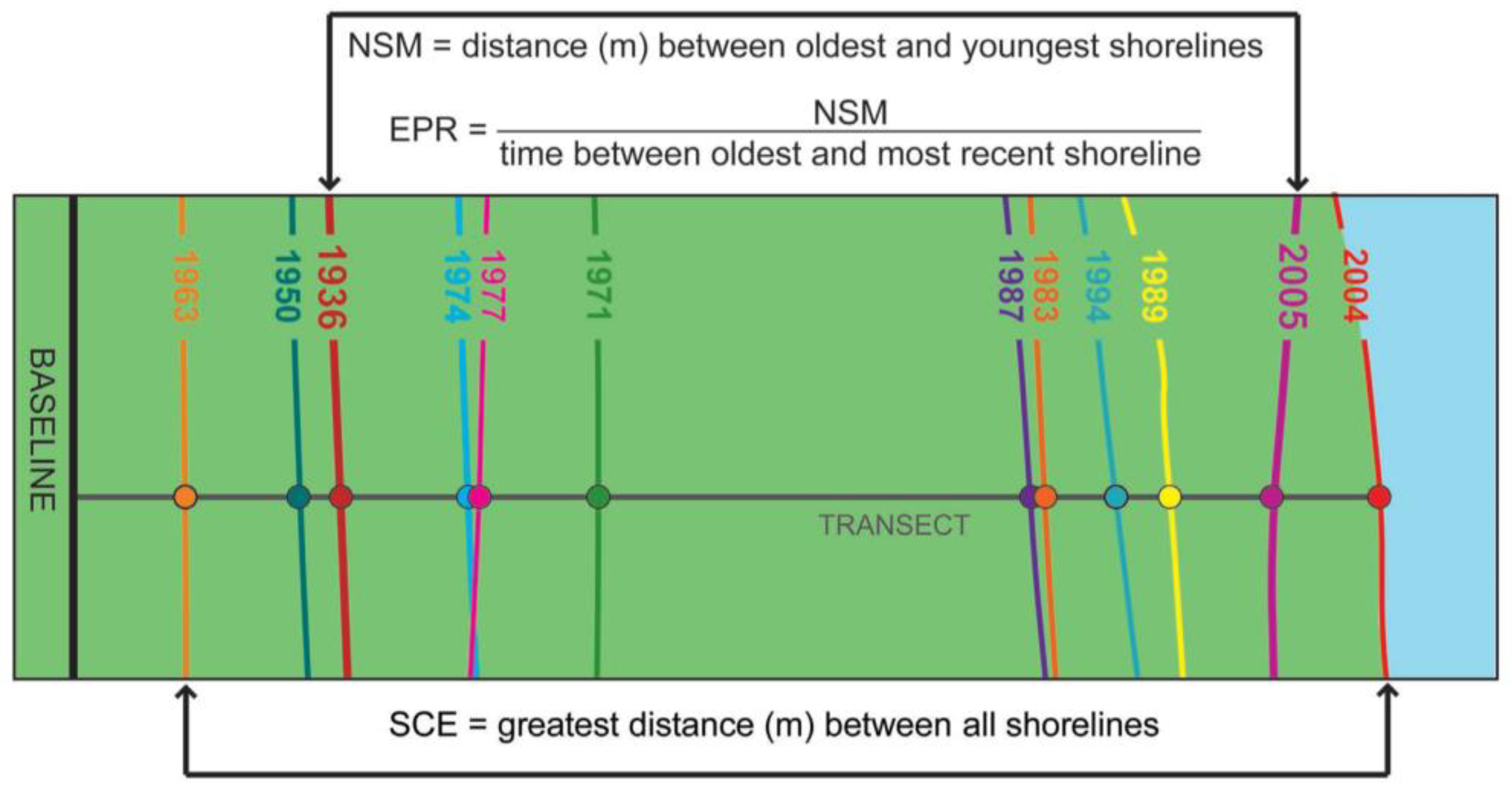
4.2. GIS for Shoreline Change Analysis and Coastal Monitoring
The Geographic Information System (GIS) has become an indispensable tool in contemporary shoreline monitoring, facilitating the precise spatial analysis and visualization of coastal change [
67]. Coupled with tools such as the Digital Shoreline Analysis System (DSAS), the GIS can facilitate the processing of historical positions of the shoreline, compute erosion and accretion rates, and visualize long-term coastal evolution. This facilitates large-scale geospatial data management, predictive modeling, and decision-making in coastal management.
Recent studies have utilized GIS to efficiently analyze shoreline dynamics and long-term coastal changes. With the aid of the Digital Shoreline Analysis System (DSAS) [
59], used as an add-on tool in ArcGIS, researchers could undertake the extraction, quantification, and prediction of shoreline changes with high accuracy. GIS plays a critical role in understanding erosion and accretion patterns and the impacts of natural and human activities on coastal environments. It enables the creation of better and more knowledgeable coastal management and protection policies.
Table 2 (GIS-based approaches to shoreline change detection) reveals concentrated information highlighting the main findings with the core technologies Sentinel-2 and Landsat aided by GIS.
Quang et al. [
11] investigated the long-term shoreline evolution in Quang Nam Province, Vietnam, with a temporal resolution of 1990 to 2019. Employing the DSAS, he analyzed satellite imagery erosion and accretion patterns, indicating significant coastal changes caused by natural processes and human activities. The methodology attempted to extract historical coastline positions from all available data scenes of Sentinel-2 and Landsat satellite series, i.e., Landsat 4–5 Thematic Mapper (TM), Landsat 7 Enhanced Thematic Mapper Plus (ETMP), and Landsat 8 Operational Land Imager/Thermal Infrared Sensor (OLI/TIRS), over the period of 1990–2019. Satellite images with a percentage below 20% land cloud cover were used for the analysis. Then, all available data were collected and utilized to detect the coastline dynamic. The estimated change rate in Quang Nam province, employing the modified Normalized Difference Water Index (mNDWI) for shoreline detection, was used to classify water and land regions on satellite images with stable performances compared to the NDWI, which contains built-up land noises. The results from the changes using the ArcGIS add-in toolkit DSAS showed that the EPR and LRR indices had a strong correlation (R
2 = 0.96). The results identified 401 erosional and 414 accretional transects in a coastline length of 81.5 km, emphasizing the dynamic nature of the coastline, with significant erosion observed in the north of the Cua Dai estuary and notable accretion in its southern segment.
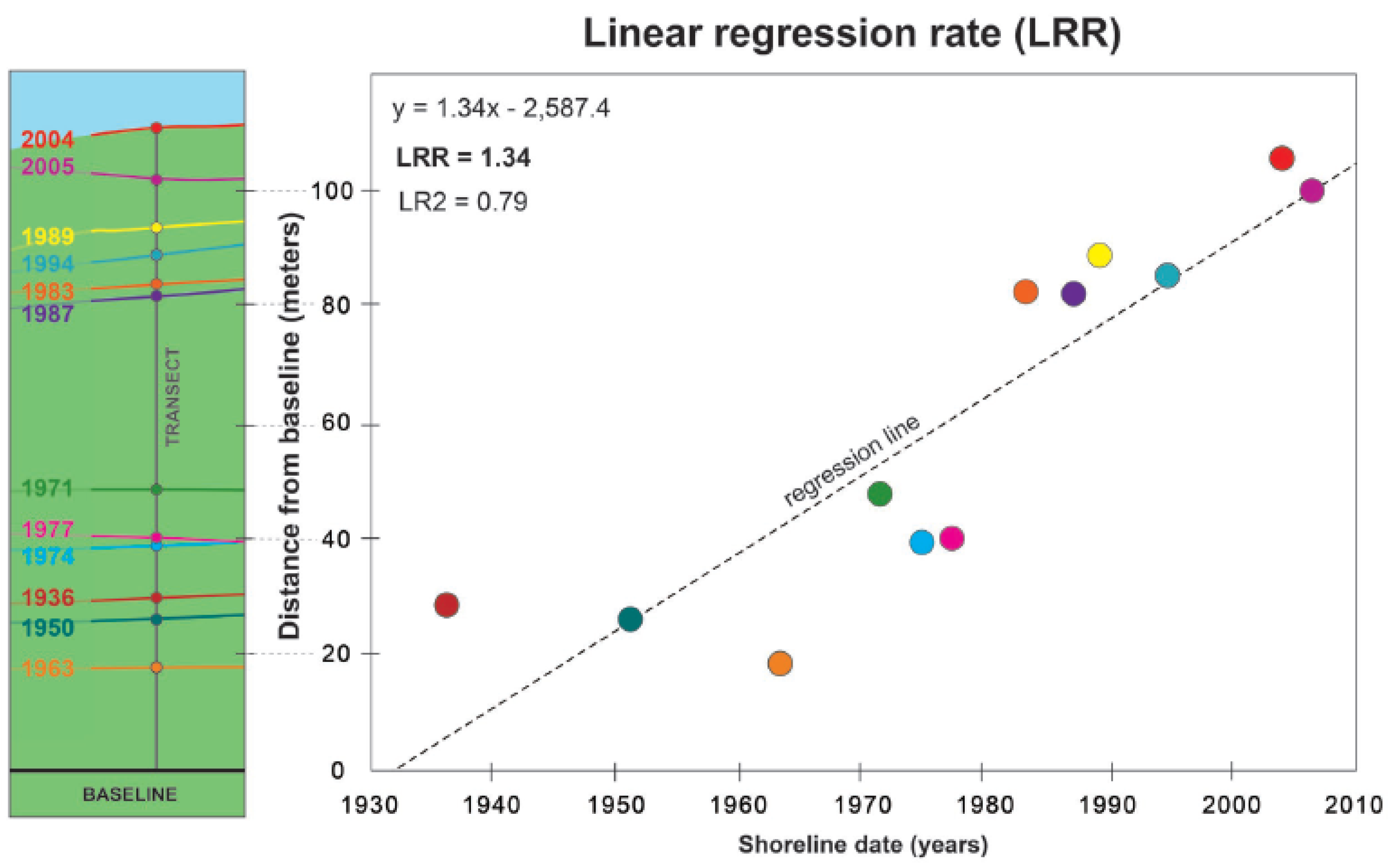
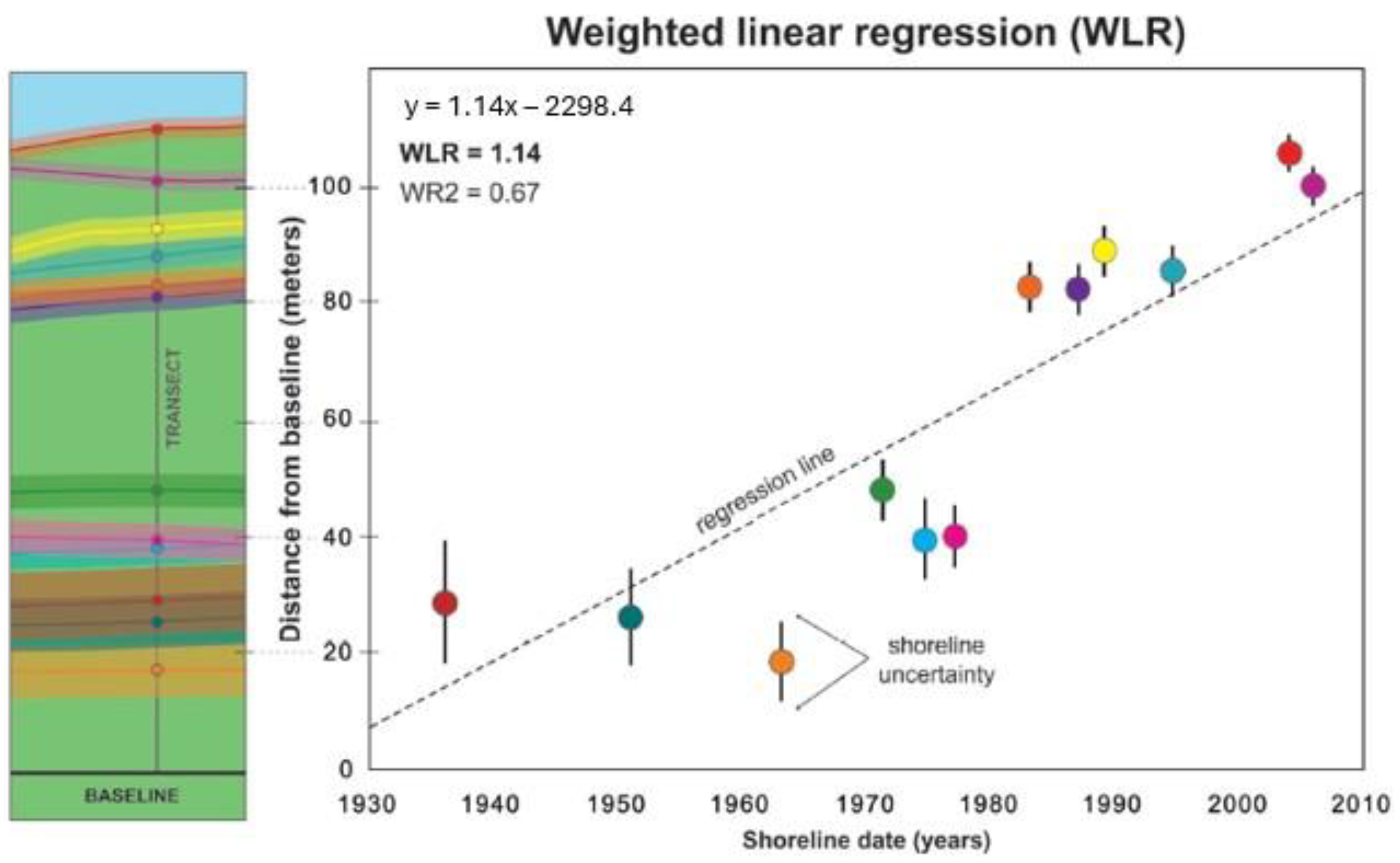
Santos et al. [
31] conducted research on the changes in the shoreline variability of João Pessoa City (Brazil) over the last 34 years (1985–2019), using multitemporal remote sensing data from Landsat 5-TM and 8-OLI satellites as a dataset, which were downloaded from the Google Earth Engine (GEE). Statistical techniques were performed, such as EPR for short-term analysis and LRR and Weighted Linear Regression (WLR) for long-term analysis provided by the DSAS. The technique was used to analyze 351 transects across 4 distinct zones, involving a detailed examination of the factors influencing the shoreline changes, including data such as the sea level, tidal range, wave height, beach morphology, and ocean currents. The statistical methods used included Standard Deviation (SD) and the Coefficient of Variance (CV), which are capable of interpreting the spatiotemporal changes along coastline transects. In one case for Zone 1 during the period of 2014–2019, the CV (2064.2) and SD (3.89) had high values, which implied inconsistency among the data, validating the need to use statistical methods for correct data interpretation. The study identified cyclical patterns of erosion and accretion within specific periods, indicating that various environmental and human activities and factors influence the coastal area’s dynamics, highlighting that the GIS plays a significant role in environmental monitoring and demonstrates the importance of coastal changes.
Görmüş et al. [
38] used 96 Landsat images to carry out a long-term shoreline change analysis for the black sea coastline. The coastline was divided into 28 subsections with 78,943 transects. Landsat (MSS, TM, ETMP, and OLI) images from 1972–2018 were used, with a total of 96 images. The spatial resolution of Landsat 1,3,5 (MSS) is a 60 m resolution, and for Landsat 5 (ETM),7,8, the spatial resolution is 30 m. For the large area of the 5000 km coastline covered by the research, the spatial resolution was appropriate. Once again, the NDWI method was employed to acquire the base image for shoreline delineation. The author indicated that stable performance is provided by the NDWI method. In any case, the validation of the study results via the georeferencing and digitization of aerial photos or in situ measures was unavailable. The images were referenced with WGS84, and digitization was limited by converting automated extraction into a semi-automated process. The shoreline change was computed using the DSAS, which applied the EPR and LRR approaches. LRR indicated a −0.17/m shoreline change, which is considered logical according to a large-scale basin’s erosion and accretion balance. The research detailed other countries and coastline sections, indicating local hotspots. Transects in the methodology matched similar investigations, leading us to conclude the validation of this method.
Matin et al. [
32] analyzed the dynamic shoreline of Bangladesh over the last thirty years (1989–2019) with a five-year interval using the dataset of multi-temporal Landsat images with a 30 m resolution and a comparison of tidal conditions collected from 1989–2019. Manual digitization of shorelines was performed. The DSAS was used to analyze the transects. There were 12,000 transects cast with 50 m intervals, resulting in shoreline retreat. Supplementary analysis of polygonal was carried out in ArcGIS, where the net area for shoreline extraction was determined for the entire study period. The LRR method for the shoreline movement NSM was analyzed. Thus, net erosion and accretion for the whole area were carried out, tracing the spatial changes in the area.
Mishra et al. [
12] analyzed the short-term and long-term changes in the shoreline of Ganjam district, Odisha, India, between 1990 and 2019. Multiresolution and temporal datasets of Landsat sensor, Thematic Mapper (TM), Enhanced Thematic Mapper (ETM), and Operational Land Imager (OLI) datasets were used for the shoreline change analysis. The DSAS was used in the GIS. Land and water discrimination methods, such as the NDWI, mNDWI, EWI (Enhanced Water Index), and WRI (Water Ratio Index), were employed to extract the shoreline. The authors continued with projections of the coastline’s future line for the 2030–2040 period and the potential impact on the area. The analysis used the EPR, WLR, and trigonometric functions to examine shoreline changes from 1990 to 2019 and predict future conditions for 2030 and 2040. The short- to long-term shoreline assessments identified erosion.
GIS-based techniques, enabled through the DSAS, have been found to be invaluable for the analysis of long-term shoreline changes in varied coastal environments. Using Landsat and Sentinel-2 imagery, erosion and accretion patterns have been mapped successfully, with parameters such as the NDWI, mNDWI, and WLR improving shoreline extraction accuracy. The main findings and geospatial methodologies utilized in the studies under review are presented in
Table 5, showing how the DSAS allows for effective multi-temporal analysis of shoreline changes. Commonly, studies involving the DSAS utilize EPR, LRR, and WLR metrics on Landsat or Sentinel-2 imagery, demonstrating different spatial patterns of change and supporting the versatility of GIS monitoring tools in different coastal environments.
4.3. Ground Truth Data for Enhanced Coastal Monitoring
Ground Truth Data (GTD) are instrumental in refining the accuracy and reliability of shoreline change detection inferred using satellite-based methodologies. High-precision field measurements like GNSS-RTK or GNSS-RTN surveys, Ground Control Points (GCPs) based on robotic total stations, terrestrial laser scanners (TLS), and RTK-corrected UAV-based photogrammetry are usually included in GTD [
34,
67,
87]. These in situ measurements act as verification references for the corroboration of shoreline positions derived from remote sensing indicators like the NDWI and mNDWI and are frequently overlayed in the GIS space for the evaluation of spatial discrepancies using indices like RMSE or regression R
2 [
9,
53,
57]. For instance, Matin et al. [
32] digitized 12,000 shoreline transects in order to calibrate extractions based on Landsat, whereas Taveneau et al. [
34] combined GTD with sediment transport modeling and real-time high-resolution video monitoring. In predictive modeling activities like those using the Kalman Filter, GTD are the key input necessary for affirming shoreline forecast reliability in dynamic settings [
2,
15]. As tabulated in
Table 6, GTD allow for the strong validation of outputs inferred from satellites, enhance the accuracy of indicators like EPR, LRR, and WLR, and indirectly support the reproducibility and credibility of coastal monitoring derived outcomes [
56,
70].
Hossain et al. [
2] analyzed remote sensing data and statistical methods to study decadal shoreline dynamics along India’s Purba Medinipur-Balasore coastal stretch. The results of his study indicated a continuous erosion pattern from 1990 to 2020, with some portions showing accretion due to land reclamation. The Kalman Filter projection of the probable positions of the shoreline in 2031 and 2041 indicates urgent management needs along the coasts to protect against erosion impact and damage to communities that will be exposed. Islam et al. [
3] investigated Nijhum Dwip, Bangladesh, where land cover and shoreline changes are associated with a 20-year data timeline. The researchers observed that the primary changes in mangrove loss are driven by rapid settlement expansion due to population pressure and economic development. Shoreline accretion outpaced erosion, adding about 1153 hectares of land. This study underlines how rising sea levels coupled with anthropogenic activities require a well-managed strategy so that development can occur alongside the protection of the environment.
Mao et al. [
15] presented an effective way of quantifying decadal shoreline changes on a large scale using remote sensing and geospatial analysis. The authors also hint at the possibility of urgent automated coastline monitoring, thus reducing the need to involve human labor. This is a very effective methodology that investigates long-term shoreline variations, which are of essence for making informed decisions in the management of the coastal zone.
Taveneau et al. [
34] explored coastal erosion in Langue de Barbarie, Senegal, through predictive models based on environmental factors like wave action and sediment transport. Real-time observations combined with predictive modeling provided valuable insights into the various shoreline movements likely to happen in the future. This work also helps underline the value of these tools for improving coastal risk management strategies.
Thakur et al. [
6] examined shoreline changes and their impacts on mangrove ecosystems using the NDVI index in the Sundarbans, India. Through remote sensing, they documented rising sea levels and human activities resulting in unprecedented mangrove loss and shoreline retreat. The study emphasized the urgent need for sustainable shoreline protection, mainly to protect the biodiversity of this region and the people depending on it.
Regarding the validation process, GTD play a very relevant role in enhancing the effectiveness of shoreline change detection since these are real-world, precise points used for the calibration and validation of remote sensing methodologies. For example, Daud et al. [
40] showed how ground truth data from RTK-GPS measurements increased shoreline position precision derived from Sentinel-2 imagery. In fact, by aligning outputs from satellite-based methods with ground-based observations, the study achieved a value of less than 5 m for RMSE using GTD corrections instead of more than 15. Similarly, Halder et al. [
9] discussed the potential of using GTD to reduce noise due to cover from clouds and water turbidity as opposed to what was seen on Landsat imagery to achieve consistent temporal datasets for shoreline position accuracies. The integration of GTD should be especially effective in such an environment where tidal effects are complex. Wang et al. [
57] used GTD acquired during high- and low-tide periods to correct the tidal effects in satellite-derived shorelines, reducing misclassifications by 25% in a coastal area like Chongming Island. Ayalke et al. [
67] further reiterated this using GTD to separate the natural shoreline from the anthropogenic features in the urbanized area. This approach resulted in a higher-than-15% increase in the delineation accuracy of shorelines. In sediment-rich environments, such as those studied by Da Silva et al. [
70]. GTD have been key in calibrating shoreline models to consider sediment plumes. This calibration, in turn, improved the delineation of shorelines under adverse optical conditions, hence reducing errors in areas difficult to analyze earlier. GTD have also proved to be of immense help in the historical analysis of shorelines. Da Silva et al. [
70] applied GTD to georeference legacy datasets such as aerial photography, which enabled valid long-term shoreline change studies over decades. In seasonal monitoring, Yiğit et al. [
56] integrated GTD to calibrate NDWI-based indices in Antalya’s coastal zones for a more accurate shoreline position with an increase in accuracy of up to 18%, and this provided important information on how to manage the areas under tourism pressure. In vegetation-dense areas, Zhang et al. [
53] integrated GTD to enhance the subpixel shoreline detection methods and achieved an RMSE of less than 6 m, while models without integrating GTD had an RMSE of 20 m.
The above-mentioned applications and reviewed studies have shown the crucial role of GTD in the monitoring of coastlines: from calibration in tidal areas to noise reduction in sediment-laden areas and georeferencing during historical analysis, GTD enhance reliability and precision for methodologies involving remote sensing, forming the fundamental basis for achieving high accuracy with respect to coastal monitoring and management.
4.4. UAV Technology for Precise Coastal Erosion Monitoring
Modern developments in remote sensing technologies have made shorelines observable by satellite-based observations and Unmanned Aerial Vehicles (UAVs). UAVs provide an ultra-high spatial resolution at a centimeter scale, which is well-suited for collecting small-scale features such as beach cusps, berms, and micro-topography [
23]. UAVs equipped with LiDAR or RTK-GPS photogrammetry have demonstrated shoreline mapping precision within 0.1 m [
88]. In contrast, satellite imagery, such as Sentinel-2 (10 m), Landsat (30 m), or even PlanetScope (3 m), covers a wider area at a lower resolution, with positional errors generally ranging from 5 to 10 m in favorable situations according to their resolution [
54,
89]. Satellites generalize the shoreline edge through pixel averaging, whereas UAVs are able to capture small changes, which are useful for local investigations like post-storm beach erosion or dune recession. The temporal consistency of monitoring is also what separates the two methods. Satellites are on repeatable revisit intervals—5 days for Sentinel-2 and 16 days for Landsat—due to which they are particularly useful in building long-term shoreline change records over a span of decades [
90].
In comparison to satellite images, UAVs provide centimeter-level spatial resolution, with much finer orders of magnitude compared to Sentinel-2 (10 m) or Landsat (30 m). UAVs are well-suited for identifying fine-scale changes in shorelines like dune crest movement, micro-erosion, or loss of plant cover. Nevertheless, in comparison to the larger spatial extent and less weather dependency, their restricted spatial scope makes them better for local-scale assessments. When used together, satellite data provide an extensive temporal and spatial scope, whilst UAVs provide detailed snapshots for in situ validation and calibration. Previous studies have illustrated this multi-resolution complementarity well, like that of Angnuureng et al. [
44] in Ghana where, in addition to satellite observation of a rapidly eroding beach, UAV photogrammetry was used [
23]. The work of Angnuureng et al. [
44] focused on the application of UAVs in coastal erosion monitoring in connection with other techniques, such as satellite imagery and VCS (video camera systems), using the case of Elmina Bay in Ghana. For this purpose, UAVs were deployed to ensure high-resolution month-to-month beach monitoring, offering detailed information about erosion and deposition along the shoreline. The results showed that UAVs could observe localized event-driven shoreline changes more accurately and frequently than satellite imagery, which does not have the necessary temporal resolution to capture such changes effectively. Complemented by a VCS, UAV data correspond reliably [
91] as a value for near real-time monitoring, indicating serious erosion was happening in extensive parts of the beach not covered in the front by jetties. UAV imagery helped emphasize how complicated the engineering solutions of sea defenses were in affecting sediment distribution and, therefore, contributing to downdrift erosion [
44]. The conclusion of this study underlined the effectiveness of drones in operation with other remote-sensing platforms for coastal management; thus, UAVs have become very critical for high-resolution monitoring, particularly for event-based changes that satellite data cannot capture.
While fixed satellite scheduling and cloud cover restrict satellite use during peak storm or tidal windows or generally rapidly occurring events, UAVs are able to overcome these by enabling on-demand deployment and exact timing control (i.e., flying at low tide or shortly after the event occurred). Although UAV campaigns are logistically complex and spatially limited—numerically only a few kilometers per flight—truly timely, focused information is provided. An example is the research by Lei et al. [
88], which mapped erosion and beach recovery prior to and subsequent to typhoon events with centimeter-scale accuracy, a challenging task to achieve with satellites alone.
A comparative framework (
Table 7) is presented below, outlining the strengths and limitations of UAV-based and satellite-based shoreline monitoring methods in terms of resolution, accuracy, revisit rate, and integration potential based on the content of this research study.
4.5. Applications of Machine Learning and Artificial Intelligence in Coastal Monitoring
Recent developments in Machine learning (ML) and Deep Learning (DL) techniques have further reiterated the role of ML and DL in the monitoring and analysis of different environments, especially coastal ones, for shoreline change detection and management. Integrating different Artificial Intelligence (AI) techniques enables the proper mapping of shorelines efficiently and precisely to allow erosion prediction and long-term coastal monitoring, with less human intervention and increased accuracy [
20].
Table 8 (application of AI methods for automated shoreline change detection and coastal monitoring) illustrates the research on AI methods applied to automated shoreline change detection and coastal monitoring. Some of the outstanding studies in our review criteria are highlighted, in which AI-based models have been applied to improve shoreline monitoring activities using different methods.
Erdem et al. [
20] developed a new model technique, WaterNet, which is an ensemble deep learning model designed to automatically extract shorelines from satellite images. The Intersection over Union (IoU) and F1 scores are crucial metrics for evaluating the accuracy of segmentation models, particularly in shoreline extraction, where they measure the model’s ability to differentiate between land and water in satellite images. The IoU assesses the overlap between the predicted and actual shorelines, with a high score of 99.59% indicating exceptional model accuracy. The F1 score, a harmonic mean of precision and recall, balances these two metrics, with a remarkable score of 99.79% highlighting the model’s precision and comprehensiveness in identifying shorelines. These impressive results were achieved using the WaterNet model, an ensemble deep learning approach designed for automatic shoreline segmentation from Landsat 8 OLI images specifically from Landsat 8 OLI data. WaterNet integrates five different architectures: Standard U-Net, Dilated U-Net, Fractal U-Net, FC-DenseNet, and Pix2Pix. Each method has its own unique strengths and is applied differently: U-Net is effective for biomedical image segmentation, Dilated U-Net eliminates pooling layers to preserve resolution, Fractal U-Net enhances accuracy by combining different visual feature levels, FC-DenseNet takes dense blocks in advance to increase feature sharing, and Pix2Pix utilizes generative adversarial networks (GANs) for pixel-to-pixel image translation. WaterNet employs a majority voting algorithm, where each model “votes” and decides on the classification of each pixel, enhancing robustness, accuracy, and reliability. The ensemble approach results in high precision, with Intersection over Union (IoU) and F1 scores surpassing 99%, making it highly reliable for real-time coastal monitoring and resource management.
McAllister et al. [
21] provided an overview of shoreline extraction techniques, particularly in Multispectral Imaging (MSI) and ML applications. The article’s discussion ranged from the more traditional approach, water indexing, to an advanced ML and image segmentation technique. One of the key points this work showed is the difficulty of elaborating a method that can be universally applied to monitoring shorelines regardless of type and location on Earth. This is because of the variation of coastlines, such as sandy beaches, cliffs, and dunes, for which individual extraction needs are expected. In this paper, applying Convolutional Neural Network (CNN)-based machine learning methods will improve shoreline detection accuracy with large-scale monitoring. On the other hand, this review focuses on certain points of attention in current approaches concerning the need for automation and scaling up of methods, with particular attention to shoreline extraction at a global scale. Conclusively, the overall suggestion of this paper is that integrating MSI with machine learning can ensure more sustainable and efficient shore monitoring. However, the further refinement of methods will be necessary for broader application. This is in agreement with, for instance, Erdem et al. [
20], whereby these ensemble learning techniques, including WaterNet, were applied to automate shoreline extraction from satellite images by merging multiple deep learning models to improve the models’ precision and reliability. In comparison to other reviews on coastal monitoring technologies, this paper aims to emphasize the incorporation of advanced methodologies, particularly AI and UAVs. However, integrating insights from studies like McAllister et al., 2022, could enhance the discussion by offering a global perspective on shoreline detection through the use of multispectral imaging and AI. McAllister et al., 2022, offered a comprehensive analysis of Convolutional Neural Networks (CNNs) for shoreline mapping, emphasizing their adaptability across diverse geographic and environmental contexts. For instance, their work detailed how traditional CNN-based models perform well in processing multispectral datasets from Sentinel-2 and Landsat but may struggle in environments with complex geomorphology, such as sediment-heavy coasts or vegetated shorelines [
21]. Referencing McAllister et al. allows a direct benchmark comparison for WaterNet. While WaterNet emphasizes high classification accuracy and reduced error margins, McAllister et al., 2022, provided insights into the computational efficiency and scalability of CNN-based models for large-scale shoreline monitoring. A comparison of this nature would enhance the discourse by placing WaterNet within the larger framework of AI-driven coastal monitoring technologies, thereby highlighting its advantages in relation to conventional methodologies [
21].
Furthermore, Almeida et al. [
33] stated that AI will play a more competitive role in automated coastal analysis systems. Their research integrated space imagery with machine learning to create a Coastal Analyst, which can automatically process large volumes of remote sensing data with minimum human intervention. While specific architectures were not profoundly explored, the paper underlined the role of AI in enhancing efficiency in data processing by several orders of magnitude and, hence, supporting better decision-making in coastal management by providing quasi-real-time insights into environmental risks such as erosion and urban expansion.
Angnuureng et al. [
44] applied AI to multi-platform data by integrating satellite, drone, and video camera platforms to monitor coastal dynamics. ML algorithms played a central role in integrating these data sources, allowing for high-resolution and accurate monitoring of shoreline variations. Moreover, the multi-platform methodologies proposed represent higher spatial and temporal resolutions, complementing the gaps left by traditional single-platform monitoring approaches. ML applied AI to multi-platform data by integrating satellite, drone, and video camera platforms to monitor coastal dynamics. Also, the multi-platform methodologies proposed represent higher spatial and temporal resolutions, complementing the gaps left by traditional single-platform monitoring approaches. The machine learning techniques automatically analyzed and fused heterogeneous data, thus contributing to better overall coastal monitoring and management.
Finally, Murray et al. [
50] applied neural networks to process satellite photography to map changes in the shoreline of southwestern Australia. Deep learning models, trained on millions of satellite images, showed higher accuracy in detecting shoreline change and shedding light on long-term trends in coastal erosion. This application of AI (deep learning specifically) will be very important for timely and accurate environmental monitoring, understanding, and mitigation measures for coastal erosion, which are key to preserving coasts, ecosystems, and infrastructural-related results. These studies epitomize the transformational role of machine learning and deep learning in coastal monitoring. AI techniques, primarily ensemble and deep neural networks, have emerged as powerful tools for analyzing large-scale and complex datasets that provide accurate and timely information on shoreline dynamics, erosion patterns, and environmental changes. Their merger through AI and remote sensing technologies offers scalable and automated solutions for coastal management, enabling proactive responses to environmental risks and ensuring sustainability in managing coastal resources.
Chatzipavlis et al. [
92] presented a new modeling methodology of beach realignment using a neuro-fuzzy neural network optimized using a backtracking search algorithm. This model is a reasonably competent approach to dealing with the nonlinearities in sediment movement caused by time-varying waves, which are beyond the resolving capability of numerical models. First-order fuzzy rules have been used to model the input–output relationship in this network. It was finally observed and concluded in this research that the backtracking search algorithm enhances performance due to the improvement of mutation and crossover operations. Using experimental data from Santorini, Greece, it was displayed that the proposed method prevails over the existing modeling techniques.
AI models, such as WaterNet, significantly outperform traditional methods like the DSAS and NDWI regarding shoreline variability. This improvement is due to the ability of AI to integrate spatial and spectral features, process extensive data efficiently, and adapt to diverse environmental conditions. For instance, WaterNet achieves over 90% classification accuracy in complex environments, whereas the NDWI typically performs at 70–80% due to the misclassification of mixed land–water features [
54,
55]. Traditional systems, such as the DSAS, rely much more on predefined parameters and thus perform inefficiently under dynamic conditions. WaterNet, trained on various datasets, copes with different tidal levels and sedimentation. Studies have shown that it reduces the sedimentation-rich coast classification error from 25% for the DSAS to below 10% [
56,
57]. In terms of accuracy metrics, WaterNet achieves a root mean square error (RMSE) of 5 m compared to 15 m for the DSAS and 18 m for the NDWI, particularly in areas with vegetation interference [
66]. Precision and recall are also superior, with WaterNet scoring 0.92 and 0.89, respectively, versus 0.81 and 0.78 for the DSAS [
37].
While AI and ML models like WaterNet have shown unparalleled advancement in the field of shoreline detection, scalability to diverse geographies and shorelines should be cautiously considered. Such models are developed for different environments, including sediment-heavy deltas, vegetated coasts, and urbanized shorelines, based on multispectral and temporal datasets [
4,
12]. WaterNet can process high-resolution UAV imagery or medium-resolution Sentinel-2 datasets, making the technology suitable for modeling complicated shorelines and capturing many environments [
2,
10]. However, the deployment of such technologies in underdeveloped regions faces serious challenges. Among the critical challenges are high-quality training datasets, which are mostly unavailable within less-developed regions because historic shoreline monitoring has not been performed, or inconsistent data collection practices. Indeed, Palomar-Vázquez et al. (2023) [
62] and Thakur et al. (2021) [
6] presented these findings. In addition, the computational infrastructure necessary for training and deploying AI models, such as access to high-speed internet and cloud computing platforms, is usually lacking in these areas. This creates a bottleneck in processing large datasets and implementing complex algorithms (Quang et al., 2021; Singh et al., 2023) [
5,
11]. Another important barrier to scalability involves shoreline variability across geographies. Most AI models, like WaterNet, are trained on regional datasets that cannot capture the geomorphological variability of coastlines around the world. For instance, models that have training data derived from sandy beaches have been shown to not generalize well to rocky coasts or mudflats, requiring regional calibration or retraining of the models themselves [
3,
7]. This is an expensive process and may hinder the deployment of such models in resource- and expertise-scarce underdeveloped regions. Moreover, the absence of GTD in large, underdeveloped areas has implications for the validation and accuracy of the models. Without strong GTD for calibration, the AI models may fail to capture local tidal variations, vegetation interference, or anthropogenic impacts and thus have higher error margins [
8,
44]. This calls for methods that effectively use limited or low-cost GTD, such as UAV-based data collection or community-led shoreline surveys. Finally, for AI models like WaterNet, scalability needs to consider how well the model fits and whether this can be achieved through partnerships with local stakeholders and open datasets, such as archival results from Landsat. Simplification of the AI models by reducing the required computation and merging them with low-cost data collection may enable greater technology access. Addressing these limitations means that WaterNet and similar models will enable wider global applicability. This ought to yield more robust means for monitoring shorelines and managing environments for underdeveloped countries.
Although there has been high accuracy exhibited by AI models in shoreline segmentation, the challenge lies in their generalizability in diverse coastal morphologies. For instance, WaterNet [
26] recorded a segmentation accuracy of >99% using high-quality images, which are unlikely to be obtained in urban or sediment-rich coastal environments without the need for model retraining. Zollini et al. [
55] also noted that their model (J-Net Dynamic) worked better on natural beaches compared to artificial constructions. Furthermore, McAllister et al. [
21] reported that regional datasets were used to boost machine learning classifications. These observations point to the fact that although AI is a powerful tool, it tends to need regional calibration and is unlikely to be directly transferable across multiplex environmental conditions without fine-tuning or model retraining.
While the focus of this review remains shoreline-specific AI applications, recent progress in deep learning architecture such as MR-DCAE [
93] and Cross-Triplet Context Learning [
94] demonstrate transferable techniques that could be applied to coastal monitoring tasks. These models emphasize robust feature learning from limited labeled data and context-aware recognition, which are especially useful in scenarios with sparse ground truth or complex spatial features. Their methodological frameworks provide a foundation for future shoreline detection models to operate under unsupervised or semi-supervised conditions.


 ,
, 


