Review

Urban Underground Space Geological Suitability—A Theoretical Framework, Index System, and Evaluation Method

1
No. 2 Brigade of Hebei Bureau of Geology and Mineral Resources Exploration, Tangshan 063000, China
2
Tianjin Center (North China Center for Geoscience Innovation), China Geological Survey, Tianjin 300170, China
3
Tianjin Key Laboratory of Coast Geological Processes and Environmental Safety, Tianjin 300170, China
4
Xiong’an Urban Geological Research Center, China Geological Survey, Tianjin 300170, China
*
Author to whom correspondence should be addressed.
Appl. Sci. 2025, 15(8), 4326; https://doi.org/10.3390/app15084326
Submission received: 26 February 2025 / Revised: 9 April 2025 / Accepted: 11 April 2025 / Published: 14 April 2025

Abstract

:
With rapid urbanization, urban underground space (UUS) development has become crucial for sustainable urban growth. This paper systematically reviews geological suitability evaluation (GSE) methods for UUS, integrating theoretical frameworks, indicator systems, and assessment techniques. We establish a comprehensive evaluation framework based on environmental strategic assessment (ESA) principles, analyzing key geological factors, including rock/soil properties, hydrogeological conditions, geological hazards, and existing underground structures. The study compares weighting methods (AHP, EWM, CRITIC) and comprehensive evaluation models (FCE, TOPSIS, BNM), highlighting their advantages and application scenarios. A case study of Xiong’an New Area demonstrates how multi-layer UUS planning integrates geological constraints with sustainable development goals. The results show that combining 3D geological modeling with hybrid evaluation methods significantly improves decision-making accuracy. The review provides practical guidance for optimizing UUS utilization while addressing current challenges in indicator selection, weight rationalization, and heterogeneity management.

1. Introduction

As urban populations continue to grow and cities rapidly develop, investments in urban infrastructure are increasing [1]. The saturation of ground space, scarcity of land resources, and worsening urban traffic congestion pose significant challenges [2]. Many cities are faced with the urgent task of meeting urban development needs within limited land resources [3]. Urban underground space (UUS) development and utilization have become crucial strategies to support urban growth, mitigate land scarcity, and improve land resource utilization efficiency [4,5,6]. The development and utilization of UUS is considered an essential aspect of sustainable development [5,7,8], representing one of the few remaining natural resources that have yet to be fully tapped into [9]. The emphasis on UUS has attracted growing interest and stands out as a novel area of research [10]. However, UUS is regarded as a non-renewable resource [11], as its physical space and spatial continuity with specific soil strength cannot be returned to its initial condition once harmed [12].
Underground cities and rock houses were built from the early beginning of architecture, with significant examples of cities: Sanmenxia in China in Henan Province, Matmata (Tunisia), Cappadocia (Turkey), Uplisciche (Georgia), Brlhovce (Slovakia), etc. [13] The selection of rock types must take into account their durability and ease of excavation. Humans have utilized stable rock formations, such as volcanic tuff (e.g., Cappadocia, Turkey) and sandstone (e.g., Ellora Caves, India), for underground living. The modern development and utilization of UUS began with the construction of the first underground railway in London in 1863 [14]. A surge in the construction of UUS occurred from the early 1960s to the late 1970s. Since the 1980s, Japan has experienced significant growth in the scale of individual underground streets, improvements in design metrics, and enhanced disaster resistance measures [15]. Major cities in the United States started constructing subways in the aftermath of the 20th century, improving urban transportation services’ efficiency and stimulating commercial growth. China’s UUS development commenced in the 1960s, initially focusing on civil air defense engineering [16]. During the early 21st century, cities, like Beijing, Shanghai, Guangzhou, and Hangzhou, began strategizing the development and use of their UUS. UUS development not only eases pressure on urban surface areas but also opens up new opportunities for urban development. There are constraints on UUS development and urban planning due to the structure of strata, hydrogeological circumstances, and a variety of engineering environmental geological impediments [17]. Challenges may arise during construction if there is not enough knowledge of engineering geology and hydrogeological states [18]. Despite this, there are still practical obstacles to UUS development, such as intricate geological situations, lack of cohesive planning, and insufficient development and utilization.
Research on the geological suitability evaluation of urban underground spaces (GSEUUS) has begun to focus on developed countries in Europe and the United States. The Underground Space Center at the University of Minnesota and the Shimizu Institute of Technology in Japan utilize appropriate living and working environments as criteria for assessing engineers and designers [19]. This includes an examination of the current status of underground land use, development trends, psychological issues, structural design, and life safety. In-depth discussions have been conducted on various design-related topics. GSEUUS primarily focuses on regions in Europe [20,21,22] and the United States [21,23]. These evaluations have involved quantitative risk assessments that consider active geological processes, such as earthquakes, landslides, and liquefaction, in conjunction with local policies. Drawing from research on underground linear engineering [24], the relationship between active faults and underground infrastructure [25], as well as hydrogeological conditions affecting underground structures [26], the United States has intensified its research efforts on UUS. This research further supports risk assessment, spatial adaptability, and related space planning initiatives. The emergence of new technical tools, such as LiDAR, InSAR, and geological radar (GPR), has enhanced the accuracy of suitability evaluations [27,28]. As research progresses, systems and methodologies for GSE indices have been developed [12,29], incorporating indicators that identify resources, which restricts development and necessitates ongoing protection. The integration of technologies, such as GIS and remote sensing, has facilitated deeper research into these areas [30,31]. The environmental impact of UUS [31,32], along with its social and economic implications [12,33] and the influence of climate change [25,34] on UUS development, has increasingly become a focal point of research. Given the systematic and complex nature of GSEUUS, the evaluation methods employed are becoming increasingly sophisticated [35,36]. Additionally, 3D modeling technology has rendered evaluation results more tangible [37], thereby enhancing the ability of suitability evaluations to inform decision support systems (DSS). UUS is recognized as a significant component of land planning [38], prompting the incorporation of a policy framework for UUS into urban planning policies [39], which underscores the necessity of integrating UUS considerations into urban planning [39]. An authoritative report released by the National Academy of Sciences systematically summarizes the geological, engineering, and policy frameworks relevant to the development of UUS in the United States [40]. With the acceleration of global urbanization process, environmental Strategic Assessment (ESA), as a fundamental tool for global land use planning, ESA emphasizes the systematic integration of environmental and social factors at the Policy, Planning, and Program (PPP) level to prevent irreversible impacts of development activities on ecosystems [41]. In the context of UUS development, ESA offers a decision-making framework for GSE through multidisciplinary collaboration, stakeholder engagement, and long-term impact forecasting. For instance, the EU Strategic Environmental Assessment Directive (2001/42/EC) (SEA Directive) [42,43] mandates that major infrastructure projects assess potential risks to soil, hydrology, and cultural heritage during the initial planning phase [44]. In the past five years, an examination of the keyword “geological suitability evaluation of urban underground spaces“ reveals that a significant portion of the relevant literature has been authored by Chinese scholars, with research primarily concentrated in various cities of China. The methodologies employed for these evaluations are increasingly reliant on mathematical calculations, often utilizing a combination of various methods [45]. Additionally, the survey techniques adopted include a range of innovative exploration technologies [18,46], leading to a transition in the depiction of geological structures from 2D evaluations to 3D digital simulations [47,48]. This trend is closely tied to China’s policy framework, where national initiatives, such as “changing the urban development model” and “promoting new urban construction,” have been established. These measures aim to harmonize the utilization of aboveground and underground spaces through development strategies characterized by “functional complexity” and “3D development” [49]. Consequently, local governments are tasked with formulating comprehensive planning and management strategies for key areas, tailored to the size and specific requirements of their cities. Thus, suitability evaluations serve as a scientific foundation for enhancing urban quality.
Geological suitability evaluation (GSE) development is a systems engineering. Selecting the right evaluation method is key to accurately and scientifically assessing the suitability of UUS development [30,50,51]. When it comes to developing UUS, one must prioritize evaluating the geological suitability of the area based on the specific conditions of the city [52]. This involves choosing evaluation indexes that are tailored to the development and utilization conditions of the space, with a focus on addressing environmental geological issues that may pose obstacles to UUS development [17]. To ensure a comprehensive and accurate evaluation, key indicators, such as topography, landform, engineering geological properties of the rock and soil mass, hydrological conditions, adverse geological impacts, and the 3D structure, must all be taken into consideration [53]. Furthermore, it is crucial to also consider the presence and distribution of underground structures, cultural relics and remains during the evaluation process. secondary indexes are formulated depending on the municipality’s specific attributes and the existing conditions of UUS [52]. Qualitative evaluation relies on geological data and urban geological survey standards to assess geological conditions and draw conclusions on suitability [52,54]. Appropriate evaluation methods can assess geological data and relevant standards to determine the feasibility of UUS development. On the other hand, quantitative evaluation involves analyzing the impact of factors using mathematics, engineering geology theory, and local conditions [4,51,55]. Establishing a more complex evaluation system would necessitate the incorporation of additional methods for processing diverse data, making the use of computer assistance essential. This allows decision makers to draw conclusions on suitability to support urban planning and construction. Master planning of UUS is essential for guiding the orderly utilization of such spaces. Qualitative evaluation focuses on analyzing geological data and norms to determine suitability, while quantitative evaluation involves analyzing factors using mathematical and engineering geology theories. Master planning plays a significant role in guiding the orderly utilization of UUS [2,56,57,58].
This study explores the significance of GSE for the utilization and development of UUS, drawing from experiences on global scale. Beginning with the evaluation objectives, elements, and steps, the theoretical framework of Geological Evaluation for GSEUUS is systematically presented. The indicators used in the evaluation are elucidated from the perspectives of geological bodies, geological resources, geological environments, geological disasters, and underground structures. It delves into the importance, function, and essential nature of these assessments, along with examining the content, methodologies, criteria, factors influencing, and suitable conditions associated with this practice. Additionally, it reviews and scrutinizes the present obstacles and future directions of GSE techniques. These results provide a basis of scientific knowledge for the sustainable advancement and use of UUS.

2. The Basic Frame of the Geological Suitability Evaluation of Urban Underground Space (GSEUUS)

2.1. Evaluation Objectives

The objective of GSEUUS must be framed within the context of environmental strategic assessment, grounded in geological safety, and pursued through multi-objective coordination. By leveraging technological innovation and policy coordination, the assessment aims to analyze the conditions of underground space resources (USR). The evaluation serves as a foundation for informed decision-making regarding the development and use of UUS by thoroughly examining various attributes, including spatial features, resource availability, environmental factors, and potential disasters associated with underground resources [59]. Achieving a sustainable future requires that underground development remains within capacity limits, ecological protection is upheld, and social needs are adequately addressed [41] (Figure 1).

2.2. Evaluation Elements

This comprehensive evaluation encompasses five fundamental elements: the subject of evaluation, evaluation indicators (Figure 1 green rectangle), weight coefficients (Figure 1 blue rectangle), a comprehensive evaluation model (Figure 1 yellow rectangle), and evaluator and explanation (Figure 1 purple rectangle) [62].
In GSEUUS, the subject of the evaluation is the USR, which incorporate physical aspects found on the Earth’s exterior. This includes natural elements, such as groundwater, soil, and rocks, as well as artificial constructions, like diverse engineering buildings situated both above and beneath the Earth’s surface. Additionally, it is essential to consider conceptual elements, which include the various concepts, principles, and knowledge necessary to comprehend the system’s elements, structures, and functions. Furthermore, this evaluation must take into account the various regulations, planning documents, technical standards, and emergency plans established to govern and manage the interactions between humans and the Earth [59].
Choosing the appropriate evaluation indicators must adhere to the principles of independence, comprehensiveness, quantifiability, and measurability. It is essential to incorporate all relevant indicators for assessment while minimizing any redundancies among them. Furthermore, the indicators should be appropriately refined. When a single indicator can be articulated through multiple evaluation metrics, it facilitates the differentiation of indicators and enhances the analysis of the issues at hand. Importantly, the information required for these indicators should be readily accessible.
The weight coefficients play a vital role in quantifying the evaluation index, as it indicates the importance of that index. There are several techniques for determining the weight coefficient, such as the method of expert survey, the analytic hierarchy process (AHP), and the entropy weighting method (EWM). Depending on a solitary evaluation method might yield fixed results that do not accurately reflect real conditions or could overstate specific factors. To address these challenges, using a strategy that combines multiple methods can improve the scientific credibility of the findings. For example, applying GIS spatial analysis along with the AHP and multi-criteria analysis (MCA) [63] or utilizing the AHP guided by expert insights [64] can produce more reliable assessments.
The development of a thorough evaluation model generally depends on the measurement matrices of each system, as well as a weighted average derived from the evaluation index metrics across these systems.
It is essential for the evaluator and explanation to identify the key thresholds of the evaluation outcomes, categorize the results, and establish a suitability score. To select the critical value, various methods can be employed, including analogy, analysis of frequency curves, probability assessments, or graphical illustrations. The application status of the output products will prompt adjustments in case strategies, thereby achieving a closed-loop evaluation.

2.3. The Collaborative Mechanism Between ESA and GSEUUS

The synergy between ESA and GSEUUS must be achieved through multiple pathways. Firstly, ESA’s sustainability goals—such as reducing carbon footprints and protecting groundwater systems—should be integrated into the evaluation indicator system of GSEUUS [6]. Specifically, indicators, like the “avoidance rate of ecologically sensitive areas” and the “carbon emission intensity of underground development,” should be incorporated as binding criteria for geological suitability assessments. For instance, automatic downgrading of development suitability should occur within ecological redline zones to ensure alignment with their objectives (Figure 1 green rectangle). Secondly, during the assessment process of GSEUUS, the screening and scoping steps of ESA should be prioritized to identify geological units that require special protection, such as aquifers and fault zones. Additionally, both parties should share data and leverage ESA’s cross-domain databases, including ecological redlines and cultural heritage distribution, to optimize GSEUUS’s 3D geological models, thereby avoiding planning conflicts. Taking the groundwater vulnerability map as an example, a shared data mechanism is established to integrate the ESA data layer into the GSEUUS application scenario using methods, such as spatial overlay analysis and weight correction. Finally, by incorporating ESA’s public consultation process and organizing stakeholder workshops, community acceptance of UUS development can be fostered to address social preference biases in weight allocation [65], further promoting the collaborative synergy between ESA and GSEUUS.

3. Evaluation Indicators

Urban geological surveys can gather a range of indicators to assess geological compatibility, focusing on significant aspects of urban planning, construction, operation, and management. These surveys examine various factors, including space, resources, environment, and hazards [66]. Typically, the GSE may encompass more than ten indicators [10,67]. Bobylev categorizes evaluation indicators into two main types: non-renewable and renewable resources [12]. He further refines the non-renewable category into four classes: physical space, space with specific soil strength properties, excavated materials, and cultural heritage. The renewable category is subdivided into groundwater and geothermal energy. Parriaux classifies potential resources, encompassing USR, water resources, geothermal resources, and geological relics [68]. Based on environmental strategic assessment, establish a quantifiable data index system while ensuring geological safety, ecological sustainability, and social acceptance. (Figure 2 blue rectangle).
The evaluation indicators presented in this article integrate existing examples alongside the team’s experiences. When assessing the geological features of UUS, it is essential to consider both, ’physical’ indicators and those related to ’human activities’. Accordingly, evaluation indicators can be categorized into natural and humanistic primary indicators (Figure 2 green rectangle). Natural indicators include factors, such as groundwater, soil, and rock formations, while humanistic indicators encompass surface and subsurface engineering constructions [59]. Secondary indicators for natural elements can be further divided into geological formations, geological resources, geological environments, and geological disasters, whereas human elements pertain to subsurface infrastructures (Figure 2 yellow rectangle).
The selection of indicators for 2D GSE is constrained by factors, such as the specific evaluation target, the level of information mastery, the accuracy of survey, and the dispersion of data. In contrast, a multi-layer or 3D GSE may require a more comprehensive set of evaluation indicators. The challenge in 3D GSE lies in effectively capturing the plane and layered heterogeneity of each parameter to better reflect the actual geological, engineering geological, hydrogeological and environmental geological conditions [69]. Including ecological data, social data, engineering data, etc. in the evaluation index would hold more practical significance [55,70] (Figure 2 orange rectangle). The subsequent discourse in the article elaborates on tertiary indicators, their characteristics, and methods of data collection.
Figure 2. GSE index system based on ESA [61,71,72,73].
Applsci 15 04326 g002

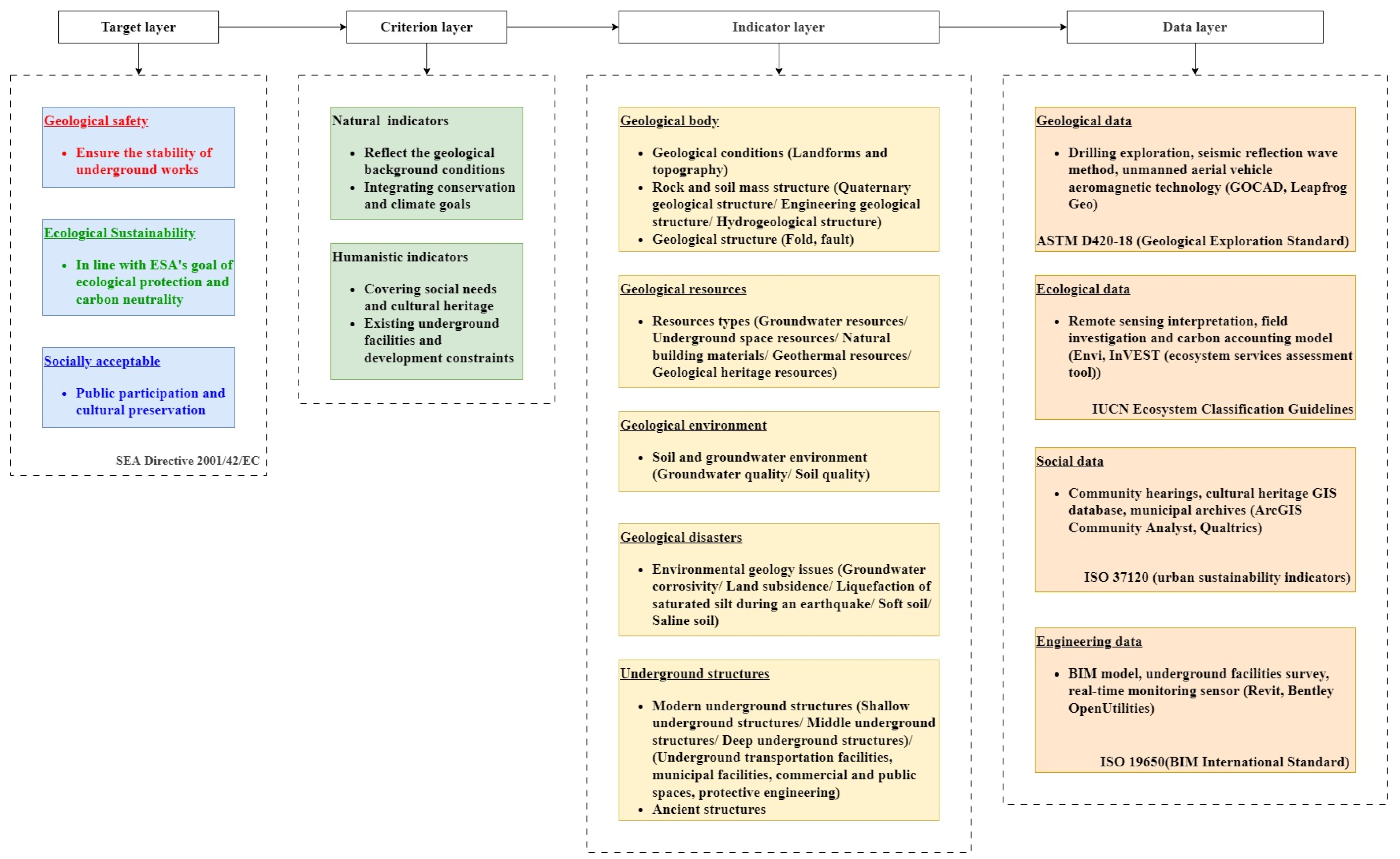
3.1. The Geological Body

The geological body acts as the basis for the development and utilization of UUS resources, as well as the underlying factor that influences the conditions associated with these resources. Consequently, geological conditions are paramount in the evaluation of UUS [74]. While geological bodies are tangible entities, geological modeling—whether in 3D or 2D form—primarily aims to investigate the geological body itself. The geological conditions of a geological body reflect its natural endowment and significantly influence the suitability and feasibility of developing and utilizing UUS. Geological conditions, along with rock and soil structure and geological structure, comprise the tertiary indicators of the geological body (Figure 2).

3.1.1. Geological Conditions

Geological conditions reflect the formation processes and state of geological bodies. Topography and landforms serve as primary criteria for describing and distinguishing these geological conditions. For instance, significant variations exist in the geological conditions of plains, coastal regions, and mountainous areas. Human habitation predominantly occurs in plains, hills, and certain mountainous landforms, with the development and utilization of UUS primarily taking place in these areas, particularly in plains. The influence of terrain on UUS planning and design is direct [75], as terrain relief and slope significantly affect both the appearance and suitability of UUS for various human activities. Through geological surveys and associated methodologies, along with remote sensing interpretation, the geological conditions of geological bodies can be effectively assessed.
The flat landform is characterized by its rich UUS resources, which consist of thick layers of sediment. In low-lying areas or flat terrain, rainwater does not drain easily, leading to waterlogging, which poses a threat to the development and utilization of UUS. In contrast, hilly areas require careful consideration of topographical impacts. Constructing infrastructure in rolling terrains can be prohibitively expensive due to the complex engineering and geological challenges involved. In mountainous regions with a single bedrock, the development of UUS is often difficult and lacks strong demand, except for specific purposes, such as national defense. Additionally, the costs of development and construction timelines are crucial factors that must be taken into account. When establishing parameters, slope, aspect, and landform type should be utilized as primary evaluation attributes indicators.

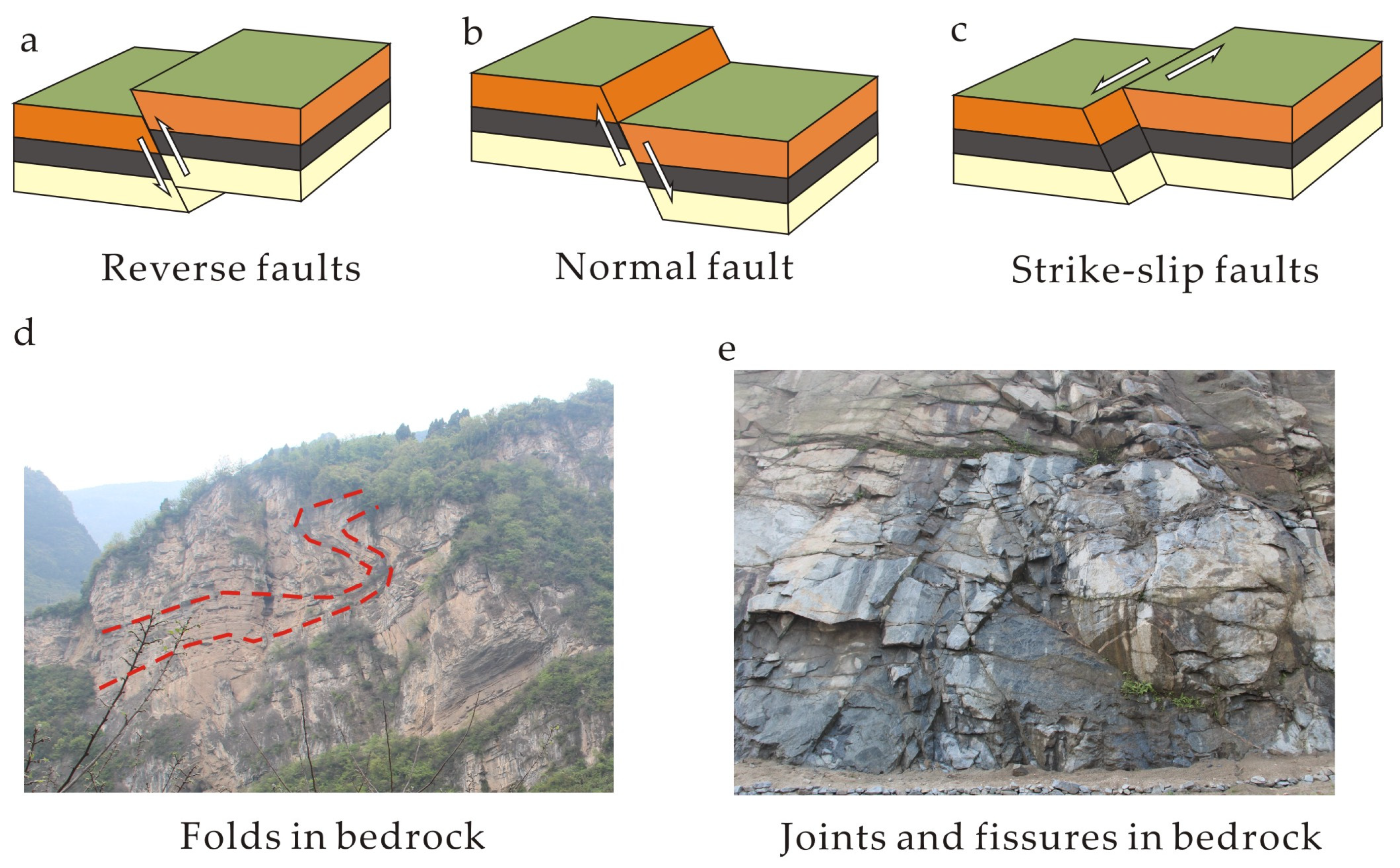
3.1.2. Rock and Soil Structure and Geological Structure

The generalization of rock and soil structure and property parameters is typically crucial for GSEUUS. A comprehensive description of the thickness, properties, and interrelationships among the various geotechnical layers is essential, with a particular focus on the physical and mechanical properties of each layer. It is important to consider the impact of structural features, such as faults and folds, on the development of UUS and to identify potentially unstable areas. Geological drilling, in-situ testing, and laboratory testing can aid in constructing rock and soil structures and in quantifying stratigraphic property parameters. Additionally, geophysical detection technology is commonly employed in UUS exploration and in the detection of field geological resources [76,77].
(1) Quaternary geological structure;
UUS development is typically more active in shallow regions, particularly within the Quaternary strata. Consequently, understanding the Quaternary geological structure is essential for studying the geological origins of UUS layers and addressing origin-related geological issues. It is imperative to analyze the types and causes of Quaternary sediments, including alluvial, diluvial, and aeolian deposits, through drilling, geophysical prospecting, and experimental test analysis, while also evaluating their impact on the stability of UUS. Alluvial and lacustrine strata are relatively stable and suitable for large-scale development; however, diluvial layers, are characterized by larger particles and poor sorting, present challenges for the creation of UUS, with groundwater infiltration being a significant concern. Conversely, marine and swamp-phase sedimentary strata typically contain soft soil, which can be relatively corrosive [78,79]. Therefore, delineating Quaternary geological divisions based on their structural characteristics is crucial for informed evaluation.
(2) Engineering geological structure;
Engineering geology is essential for GSEUUS. It involves analyzing the engineering geological properties of each sub-layer within the geological layer group, including stratum depth, thickness, and extension, as well as addressing engineering geological issues, such as soft soil, sand soil liquefaction index, freeze–thaw properties, and expansion characteristics. Additionally, the relationship between the distance to active fault zones and rock compressive strength is crucial. For instance, bedrock typically demonstrates low weathering and high natural compressive strength, rendering it stable and safe for development, even in the face of challenging excavation conditions. The engineering properties of rock masses vary significantly by lithology [80]. For instance, granite exhibits a high uniaxial compressive strength (UCS) and low porosity (Figure 3a), making it ideal for deep underground facilities; however, joint spacing must be evaluated to avoid block instability. Limestone, on the other hand, is susceptible to dissolution, which necessitates geophysical surveys to detect potential cavities (Figure 3b). Sandstone demonstrates a moderate UCS but may exhibit high permeability, thereby requiring waterproofing measures (Figure 3c). It is important to evaluate the bearing capacity of various rock and soil layers and consider appropriate foundation treatment methods. The geotechnical properties, such as bearing capacity and compressibility, can vary significantly across different locations within the same construction area. Therefore, identifying critical strata is paramount. Engineering geological survey methods encompass engineering geological mapping, exploration, laboratory or field tests, and long-term observations. In conducting suitability evaluations, values can be assigned based on engineering geological layer groups (2D) or evaluation units (3D), allowing for the assessment of carrying capacity and unique engineering geomechanical characteristics. During 3D modeling, both spatial and attribute structural parameters can be constructed.
(3) Hydrogeological structure materials;
The development of UUS is significantly influenced by groundwater. The groundwater pressure can affect both the stability of the structure and the strength of the supporting framework [81]. Consequently, understanding the hydrogeological structure and conditions is crucial in the development of UUS. The initial task in constructing a hydrogeological structure is to develop a hydrogeological conceptual model that reshapes the spatial distribution relationship between aquifers and aquicludes. Further characterization of hydrogeological features—such as aquifer structure, groundwater level, hydraulic head elevation, dynamic characteristics of groundwater levels, and runoff recharge and drainage conditions—is essential for assessing the feasibility and safety of UUS development. The groundwater level that is too close to the surface creates unfavorable conditions for underground engineering [82]. Excavating UUS often results in groundwater leakage, which can lead to land subsidence and damage to building foundations and structures. This uneven settlement can cause further damage to buildings. Analyzing soil permeability and water storage capacity, as well as predicting the impact of rainfall and other factors on UUS, can effectively facilitate the monitoring of such incidents. A sustained rise in groundwater levels can disrupt the force balance of these structures and their foundations, potentially triggering or exacerbating secondary disasters and increasing construction costs. Scientifically and reasonably determining the waterproof level of anti-floating is crucial for the safety of UUS structures. During the evaluation, it is necessary to comprehensively consider the hydrogeological structure and the existence conditions of aquifers, selecting parameters, such as groundwater level, permeability coefficient, water storage capacity, soil type, stratum thickness, and groundwater flow direction.

3.1.3. Geological Structure

Geological structures primarily refer to faults, folds, etc. The stability of regional structures is influenced by geological features, particularly the presence of active faults within the area.
Faults refer to fractures and relative dislocations of strata resulting from applied forces. They significantly influence the development of UUS [83] (Figure 4a–c). Active faults are particularly hazardous and should be avoided during the planning stage. Fault zones can diminish the bearing capacity of soil and compromise the stability of underground structures. Excavating near these zones increases the complexity of construction due to the inhomogeneity of the rock mass and the heightened risk of landslides. Additionally, fault structures can alter the flow path and water levels of groundwater, thereby impacting drainage and water resource management in underground environments. Fracture activities pose further threats to underground structures, potentially leading to deformation or damage [84]. Consequently, it is essential to enhance seismic resistance design and implement anti-slip measures, which may escalate long-term maintenance and monitoring costs. When planning underground linear projects, such as pipelines or traffic tunnels, it is crucial to avoid intersecting major fault zones, as fault structures can lead to local stress concentrations that may damage these infrastructures. In evaluations, parameters, such as fault type, fault density, fault activity, impact width, the mechanical properties of the surrounding rock (including strength, toughness, and deformation characteristics), permeability, and displacement, should be considered.
Folds can result in complex structures within the strata, impacting the stability of UUS (Figure 4d). The configuration of these folds alters the flow paths and distribution of groundwater, potentially leading to either the convergence or dispersion of groundwater, which in turn affects the utilization and management of these vital resources. The geotechnical properties within fold zones are often heterogeneous, thereby increasing the complexity and risk associated with construction projects and necessitating more advanced exploration and design strategies. Additionally, folds are frequently associated with the concentration of mineral deposits, oil, gas, and other valuable resources [85]. Therefore, when developing UUS, it is crucial to consider the protection and rational utilization of these resources. Evaluation parameters may include the type and shape of folds, stratigraphic dip angles, rock mechanical properties, stability of fold areas, degree of fracture development (Figure 4e), and characteristics of groundwater flow.
Figure 4. Faults and folds in bedrock (Photographed by Y.B. Xia. in Zigui, Hubei Province, China, in 2015).
Applsci 15 04326 g004

3.2. Geological Resources

The urban underground encompasses a diverse array of valuable resources, including space, water, energy, and geological materials [82] (Figure 2). Conflicts may arise in the development of various types of urban underground resources. Therefore, it is essential to understand and scientifically evaluate the diversity of these resources, as well as to implement comprehensive planning and management strategies for their development.
(1) Groundwater resources;
Groundwater resources, as a valuable asset, necessitate the implementation of appropriate protection measures during the planning of UUS [86]. While surface water serves as the primary source of drinking water for some cities, it is essential to conduct thorough investigations and ensure the protection of groundwater [87]. Surface water is inherently fragile and groundwater can act as an emergency recharge source when it becomes contaminated or degraded [82]. Based on the findings from water quality assessments and hydrogeological drilling, groundwater protection zones are delineated according to water quality grades and abundance. In areas of significant water supply importance within the city, which serve as urban emergency water supply sources, the development of UUS is subject to restrictions.
(2) Underground space resources;
The author posits that not all UUS qualify as effective resources. The development of UUS must preserve the geological structure and its functions to a certain extent, while also protecting the scale and quality of the overlying geological resources. Only under these conditions can we consider the developed resources as effective USR. Prior to development, it is essential to determine whether the primary layer for UUS development will be situated within an aquifer, aquifuge, or across multiple geological layers. Based on the characteristics of the aquifers, suitable “skylights” should be selected as channels for UUS development. It is inadvisable to excavate aquifers directly or to construct extensive underground structures that span multiple aquifers. Such actions would inevitably transform the area housing the underground structures into a pathline for groundwater flow, leading to issues, like soil erosion and groundwater mixing. This would compromise the quality of high-quality groundwater and elevate the risk of pollutant infiltration. Furthermore, development should not excessively occupy aquifer space, disrupt the groundwater flow field, create localized groundwater mounds, increase the buoyancy of nearby underground structures, or heighten the risk of secondary disasters [88]. Therefore, it is crucial to strategically arrange the thickness of UUS development and utilization with the aim of protecting the aquifer during evaluations, using the developable thickness and range as key factors in GSEUUS.
(3) Natural building materials;
The natural building materials discussed in this article pertain to geotechnical materials, such as sand, gravel, and granite. Historically, these materials have been essential for human settlements, from ancient adobe structures to Roman concrete (volcanic ash-based) [89]. In modern UUS development, natural materials serve dual roles. Crushed rock and sand form the backbone of concrete and backfill materials. Low-permeability clays are used for landfill liners and waterproofing layers. On the one hand, there is a significant demand for construction materials; on the other hand, much of the excavated geotechnical materials are wasted, contributing to a substantial environmental burden in many cities [82]. Current advancements concentrate on optimizing material performance and sustainability. While natural building materials can serve as a secondary factor limiting the development of UUS, they can also be advantageous if produced during the development process. Bio-mineralization techniques enhance the strength of sand-based materials. Tunnel-excavated soils can be reused as backfill, thereby reducing waste. Geospatial tools effectively identify optimal extraction zones while minimizing ecological impact [24]. The range, variety, and quality of natural building materials can be assessed through drilling, geophysical prospecting, and experimental testing.
(4) Geothermal resources;
Geothermal resources encompass hydrothermal geothermal resources [90], dry hot rock geothermal resources, and shallow geothermal energy resources. According to the current development model, the exploitation of geothermal resources predominantly occupies vertical linear space and deep volume space. This spatial occupation does not need to be considered when GSE of large areas. However, in the detailed planning of smaller areas, it is essential to reserve UUS for geothermal development and to avoid conflicts with other underground projects during the planning phase. Consequently, GSE for existing projects should regard this as an absolute limiting factor. Areas with favorable prospects for geothermal resource development should be prioritized for UUS utilization. Since underground structures also require heat exchange, regions with abundant geothermal resources are more conducive to the large-scale development of UUS. Geothermal resources can be assessed for their resource endowment conditions through methods, such as drilling, geophysical prospecting, and in situ testing.
(5) Geological heritage resources;
Geological heritage resources encompass fundamental geological features, landforms, geological hazards, and other related elements, all of which serve as essential limiting factors in GSE. The primary method for obtaining data is through geological surveys.

3.3. Geological Environments

The geological environment pertains to the quality of soil and groundwater relevant to the development of UUS (Figure 2).
(1) Quality of groundwater;
The quality of groundwater refers to the extent to which it has been affected by human-induced pollution. When groundwater becomes contaminated, it can significantly impact the development of UUS. Sources of contamination include leachate from landfills, gasoline leaks from gas stations, and pollutant discharges from biochemical product plants, among other incidents. Such contamination adversely affects both groundwater and soil quality [91,92]. Moreover, it poses exposure risks to construction personnel involved in UUS development projects, as well as risks to the integrity of underground structures and their users after completion. Consequently, remediation is necessary prior to the development and utilization of UUS. Assessing groundwater quality necessitates an investigation into pollution sources, with the extent of the pollution plume delineated based on groundwater sample test results [93]. In GSEUUS, it is essential to assess human health risks associated with various pollutants, and groundwater quality should be considered a critical limiting factor [94].
(2) Soil quality;
Soil quality is closely linked to pollution, encompassing both heavy metal and organic pollution [95]. A geochemical survey of land quality is essential for determining soil quality grades and identifying the distribution of contaminated areas, followed by comprehensive soil quality assessments of these sites. Soil remediation can be implemented either in situ or ex situ. It is advisable to protect or excavate high-quality selenium-rich soil for potential reuse. In GSEUUS, it is important to assess soil quality and pollutant concentrations based on the types of pollutants present, with soil quality being considered a limiting factor.

3.4. Geological Disasters

There are various types of geological hazards; however, the selection of geological hazards for evaluation should be based on the specific characteristics of the study area (Figure 2).
(1) Corrosion of groundwater;
Groundwater in runoff discharge areas is highly corrosive, making it unsuitable for the development of UUS. This corrosive groundwater typically forms in limestone regions, mountainous and hilly terrains, humid climates, and areas associated with sulfur-containing mining activities. Additionally, groundwater in regions with saline soil also exhibits high corrosivity. Such groundwater can significantly corrode construction materials, including concrete and steel reinforcements in underground structures. To assess the corrosion potential of groundwater, sample collection and testing should be conducted. Qualitative evaluations can be performed based on the rating standards outlined in the “Engineering Geology Handbook” [96].
(2) Land subsidence;
Land subsidence refers to the vertical lowering of the ground or soil surface due to various factors, including groundwater extraction, soil compaction, and geological structural changes. This phenomenon alters the stress on buildings and underground structures, potentially leading to instability and structural damage. Geological exploration, benchmark fixed on different stratum, leveling, InSAR, and other methods can be employed to determine the cumulative settlement amount and settlement rate. Subsequently, classification and risk assessment can be conducted in accordance with relevant specifications [97].
(3) Seismic saturated sand;
Earthquake-saturated sand refers to a condition in which saturated sand loses its bearing capacity due to liquefaction triggered by an earthquake. During an earthquake, the water pressure within the soil increases sharply, weakening the contact between soil particles and causing the sand to display liquid-like characteristics under dynamic loading. This phenomenon adversely affects the stability of buildings, foundations, and underground structures. The liquefaction potential can be assessed through geological exploration, standard penetration tests (SPT), static cone penetration tests (CPT), and other methodologies.
(4) Soft soil;
Various types of soil, including soft soil and expanded clay, are susceptible to deformation, which complicates the maintenance of stability in underground structures. Soft soils [70] typically form in lacustrine and marine environments. To assess the grade of soft soil, it is necessary to collect samples and calculate the sensitivity of these soil samples.
(5) Saline soil;
Saline soils typically develop in arid and semi-arid regions, particularly in inland areas or low-lying zones adjacent to the ocean. These saline soils often corrode concrete, steel reinforcement bars, and other materials used in underground structures. To assess the corrosion potential of saline soil, sample collection and testing should be conducted. Evaluations can be performed using qualitative calculations based on the rating standards outlined in the “Engineering Geology Handbook” [96].
(6) Cave, solitary stone, freeze–thaw;
Karst caves, boulders, and freeze–thaw processes are all geological hazards characterized by significant regional variations. Karst caves predominantly form in the Custer landform area, while boulders develop in diluvial regions surrounding bedrock mountains. Additionally, freeze–thaw phenomena are primarily observed in high-latitude areas. This article will not address investigation and evaluation methods.

3.5. Underground Structures

Underground structures are primarily categorized into modern and ancient structures (Figure 2). Various protection requirements may restrict the development of UUS or complicate their implementation [82]. Three-dimensional information of modern structures must be acquired by collecting municipal data and integrating it with geophysical detection efforts, whereas the buried information of ancient structures is obtained solely through geophysical detection.
(1) The modern structures
Modern structures can be classified into several categories based on their functional uses: underground transportation facilities, municipal facilities, commercial and public spaces, and protective projects [19]. For instance, when classified by burial depth [98], structures can be divided into shallow underground structures (burial depth < 15 m), which primarily include underground parking lots, comprehensive pipeline corridors, and commercial streets; middle underground structures (burial depth 15–50 m), which mainly encompass subways, tunnels, and underground water storage reservoirs; and deep structures (burial depth > 50 m), which include deep buried laboratories and high-level nuclear waste disposal facilities. Generally, the deeper the underground structure, the greater the requirements for the development and utilization of UUS, which in turn influences the intended purpose of that space.
For shallow underground structures, classification by burial depth typically involves methods, such as open excavation [99], cover excavation [100], and shield construction. When evaluating the geological suitability of large regions, it is essential to assess the feasibility of underground open space development and reuse in built-up areas, taking into account the degree and scale of development alongside planning requirements [25,101]. Additionally, existing engineering and environmental geological issues must be considered, along with potential secondary hazards, such as uneven formations, backfill stability, local ground settlement, and impacts on underground pipelines and other structures [102]. Medium-level underground structures, such as subway tunnels constructed using the shield method and underground reservoirs, are often viewed as limiting factors for development [103]. Furthermore, local considerations may include the avoidance of geothermal wells, pump stations, and other vertical shaft projects. In the long term, deep underground structures should be regarded as absolute restrictions, given the unique characteristics of their functions and the potential for development and utilization of UUS to cause irreversible changes in regional geological conditions, such as soft soil consolidation and rock breakage.
The diversity of underground infrastructure imposes differentiated demands on geological conditions. For instance, metro tunnels must avoid water-rich sand layers to prevent water inrush during construction, while underground oil storage facilities depend on low-permeability shale layers to effectively seal oil and gas [31]. In soft soil regions, such as Shanghai, metro construction requires the use of the freezing method to reinforce the ground; conversely, in bedrock regions, like Hong Kong, the wear rate of tunnel-boring machine (TBM) cutters is directly related to rock hardness. Therefore, geological suitability assessments must customize indicator weights based on facility types—for example, assigning a higher weight to the ’rock mass integrity coefficient’ for energy facilities, while placing greater emphasis on the ’soil corrosion grade’ for municipal facilities.
(2) The ancient structures
Ancient structures can be repurposed for cultural displays, tourism, and other functions, thereby enhancing the utility of UUS. Conversely, these structures complicate the development and utilization of underground areas due to challenges, such as foundation treatment, increased costs, and restricted development potential. In practice, it is essential to thoroughly assess the preservation requirements of historical relics alongside the objectives of modern UUS development. This should be achieved through comprehensive archaeological and geological surveys, ultimately seeking a balance between the two.

4. Evaluation Method

In GSEUUS, the weighting of indices plays a critical role in ensuring the scientific rigor of the results. The determination of these index weights is essential for the rationality of the evaluation outcomes.

4.1. Weight Calculation Method

4.1.1. Expert Scoring Method (ESM)/Delphi

The expert scoring method and the Delphi method [104] are fundamentally similar evaluation techniques; however, they differ in their implementation details and focus. Both methods prioritize the collection of expert opinions anonymously to mitigate mutual influence among experts and enhance the objectivity of the assessment. Expert scoring methods typically concentrate on the direct scoring of specific items, while the Delphi Principle adopts a more systematic method to predictive inquiry [105].
Both methods are inherently subjective, relying on the personal judgment of experts. The information collection process for both methods often entails a longer evaluation cycle, as it requires gathering insights from multiple experts and conducting a thorough assessment. The absence of direct communication and discussion among experts may lead to the omission of significant information and perspectives, potentially compromising the accuracy and comprehensiveness of the forecast results. Consequently, these methods are often employed in conjunction with other techniques to minimize the impact of human error on the outcomes [7,106] (Figure 5 and Figure 6b).

4.1.2. Analytic Hierarchy Process AHP

The AHP [107] serves as a method for quantitative analysis aimed at tackling intricate decision-making challenges. The AHP breaks the issue down into several tiers by creating a decision-making framework and determining the weight of each evaluation criterion via mathematical techniques. When confronted with uncertainty and ambiguity, AHP adeptly merges expert subjective evaluations with quantitative analysis, ultimately helping decision-makers make more informed selections. The method considers the influence of various elements on the evaluation outcomes, presenting notable benefits for dealing with such issues [108]. The fundamental concept of AHP can be encapsulated by the phrase “first decompose, then synthesize.” Employing AHP in decision-making comprises several essential stages: (1) Developing a hierarchical framework; (2) Creating a decision table for program factors; (3) Standardizing to create a judgment matrix; (4) Conducting a consistency check on the judgment matrix; (5) Determining the weights derived from the judgment matrix; (6) Computing and ranking the overall weights. The AHP technique is widely utilized in various multi-factor suitability evaluations and complex system risk assessments within engineering project risk management [109,110].
Figure 5. Entity relationship diagram of main weight evaluation methods.
Applsci 15 04326 g005
The AHP presents various benefits that improve the transparency of decision-making by breaking down complex issues into different hierarchical levels, thus clarifying all relevant facets of the problem. It merges quantitative assessments with qualitative evaluations, permitting a thorough examination of diverse factors and rendering it appropriate for an extensive array of decision-making situations. AHP also offers a framework for evaluating the consistency of judgments, which aids in ensuring the rationality and precision of the decision-making process. Moreover, it accommodates multiple criteria and alternatives, making it relevant to various intricate decision-making scenarios. Thanks to its organized method, AHP is straightforward to explain and share, promoting teamwork and collaborative decision-making. Nonetheless, it is crucial to recognize that AHP is dependent on the subjective evaluations of the decision-maker, which could introduce bias and inconsistency, especially within the judgment matrix [111]. For issues with more complex hierarchies, the computation process may become laborious, particularly when a large number of comparisons is necessary. Although AHP features a mechanism for checking consistency, achieving consistent judgments remains challenging in real-world applications, especially when faced with a substantial number of assessments. Furthermore, the scales utilized in AHP might affect the precision of the outcomes, particularly if decision-makers have differing interpretations of these scales. In certain cases, decision-makers may find it difficult to accurately assign weights, resulting in less dependable final results (Figure 5).
Figure 6. Application of main weight evaluation methods: (a) [11]; (b) [30]; (c) [7]; (d) [75]; (e) [52]; (f) [74].
Applsci 15 04326 g006
The AHP is the most widely utilized method for GSEUUS. It can be employed independently to determine indicator weights [112,113] and can effectively be combined with other methodologies. This integration aims to diminish the influence of subjective judgment on evaluations and enhance their accuracy. For instance, Peng and Peng [114] combined AHP with the most unfavorable grading method (MUGM) and the exclusive method (EM) technologies to perform a comprehensive quality assessment of urban construction suitability and resources in Tongren and Changzhou cities in China. Similarly, Hou et al. [11] evaluated the overall quality of UUS in Foshan, China, employing AHP alongside variable fuzzy set theory, and a 3D geological model (Figure 6a–c and Table 1).

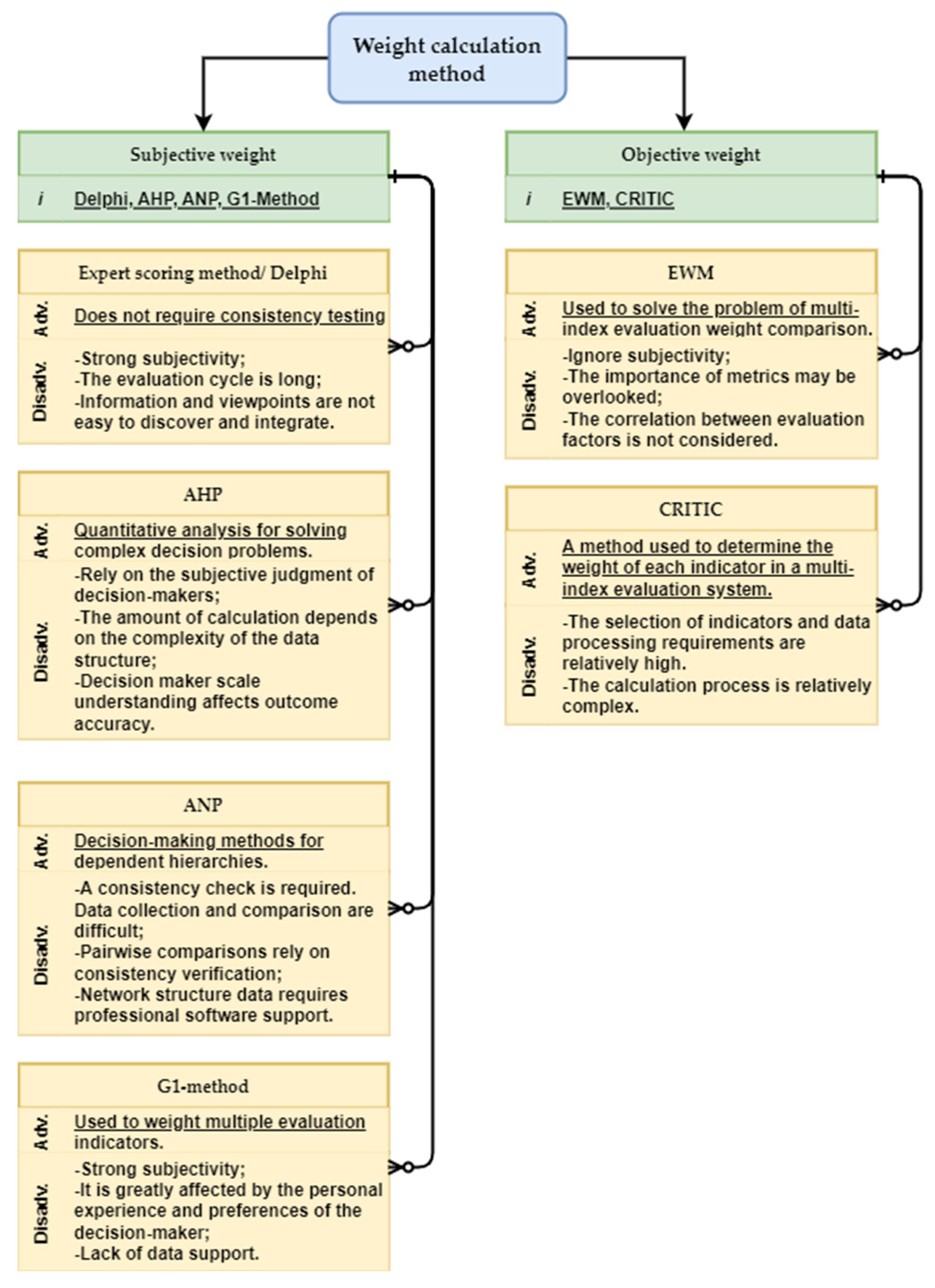
4.1.3. Analytic Network Process (ANP)

The ANP methodology is based on Saaty’s [115] decision-making framework tailored for dependent hierarchies. Compared to AHP, the hierarchical configuration of ANP is significantly more intricate. ANP features a complex hierarchy that includes loops and feedback mechanisms among the structures, as well as interrelatedness and dominance among components within the same hierarchy. When it comes to assessing factors related to geological suitability in UUS, the ANP method proves to be more effective for determining the relative significance of each evaluation criterion, given that its weighting mechanism is superior to that of the AHP method [52]. The essential calculations involved in the ANP procedure consist of: (1) creating the network structure model for the evaluation criteria; (2) developing the unweighted supermatrix; (3) computing the weighted supermatrix; and (4) obtaining the limit supermatrix to derive the final weights.
The ANP effectively handles interdependence and feedback relationships, making it highly suitable for intricate decision-making contexts. Its flexibility permits application to a wide range of decision-making challenges, with the model structure being adjustable, as required. Employing a network framework and pairwise comparisons enhances the intuitiveness of the decision-making methodology. Nonetheless, gathering data for the ANP presents difficulties, requiring the participation of several experts for pairwise comparisons, which can be both labor-intensive and challenging. Furthermore, the ANP faces challenges regarding consistency; pairwise comparisons may show inconsistencies and demand thorough testing, thereby raising the overall complexity. In larger networks, the intricacy of calculations and analyses can increase substantially, often requiring professional software assistance [116] (Figure 5).
In order to enhance the advantages of the ANP and mitigate its limitations, this technique is commonly used in conjunction with various other methods. However, there are relatively few examples of its application. In evaluating the geological appropriateness of subterranean urban areas in Hangzhou [52], the ANP was applied to establish the subjective weight of each assessment indicator. The objective weights were determined by criteria importance through intercriteria correlation (CRITIC), while the combined weights were obtained through game theory (Nash equilibrium model) (Figure 6e and Table 1)

4.1.4. Order Relationship Analysis Method (G1 Method)

The G1 method is a subjective weighting technique based on AHP. This method aids decision-makers when assessing an object characterized by various indicators, helping them ascertain the importance of each. It draws on the subjective assessments of decision-makers to form order relationships and relative importance ratios, making it especially fitting for situations that demand considerable involvement from decision-makers. In contrast to the AHP, the G1 method does not require consistency testing, making it more suitable for scenarios where strict consistency is not critical [117]. The G1 method allocates weights to various indicators according to the ordinal relationships set by decision-makers. A specific set of evaluation criteria or indicators is determined based on the evaluation objective and the subject being evaluated. The decision-maker subsequently assesses these criteria, ranking them from most to least significant, thereby establishing an ordered relationship as per their judgment. Furthermore, the decision-maker is required to present a ratio that signifies the relative importance between two adjacent criteria, typically expressed as a numerical value, r. This value conveys the significance of the former criterion in comparison to the latter. By utilizing the established order relationship along with the ratios of relative importance, a particular calculation formula—such as the eigenvector method, the inverse consistency index method, or a formula specifically tailored for the G1 method—is applied to determine the weight of each criterion.
The steps involved in the G1 method are straightforward and simple to comprehend and apply. When compared to the AHP method, the G1 method offers a less complicated calculation process, as it does not require the creation of an intricate judgment matrix or the execution of consistency tests. This method effectively reflects the subjective evaluations of the decision-maker, which makes it ideal for situations where the decision-maker’s views are crucial. Nevertheless, the G1 method’s dependence on the subjective judgment of the decision-maker can result in outputs that are excessively shaped by individual experiences, preferences, and other influences. Unlike objective weighting methods, such as the EWM, the G1 method does not provide strong data backing and may fail to accurately convey the true significance of each indicator [111] (Figure 5).
In real-world applications, the G1 method can be combined with various techniques, including the entropy weight method (EWM) and fuzzy comprehensive evaluation (FCE), to improve the precision and dependability of assessments. The G1 method, in conjunction with the EWM, is used to identify both subjective and objective weights for indicators associated with engineering geology and hydrogeological conditions in Foshan [74]. Following this, the principle of minimum discriminant information is applied to establish their aggregated weights. This strategy not only integrates expert assessments regarding the importance of the evaluation indicators but also takes into account the intrinsic properties of the data (Figure 6f and Table 1).

4.1.5. Entropy Weight Method (EWM)

The EWM serves as a multi-criteria decision-making technique that is mainly utilized to tackle the challenges associated with multi-index evaluations. This method harnesses information from data entropy, which encompasses the quantity of available information, to facilitate weight computations. It proves to be particularly useful in contexts marked by fluctuations in data, viewing these changes as a type of information. By establishing the entropy value for each metric, the EWM effectively quantifies and integrates the information related to each unit under assessment, thereby providing a relatively impartial weight for each metric. The EWM evaluates the importance of a collection of information through the lens of entropy, reflecting the extent of variability present within information collection [118]. A lower value of information entropy is associated with a greater level of dispersion, leading to an elevated weight for the index during the overall evaluation [119]. The process of the entropy weight method starts with the standardization of the initial data to remove the influence of varying dimensions across different indicators. Following this, the method computes the relative contribution of each indicator in relation to all evaluation subjects. The entropy value for each indicator is obtained from these relative contributions; indicators with lower entropy values signify a higher degree of uncertainty, thereby enhancing their influence (or weight) on the overall evaluation. Next, the variation index for each indicator is calculated based on the entropy value, which is essential for determining each indicator’s weight. In the final step, weighted calculations are executed to derive the overall evaluation indicator [120,121].
The EWM serves as an unbiased technique that assigns weights according to the extent of data variability [122], thereby effectively removing subjective influence. Nonetheless, this method might neglect the importance of specific indicators, which could lead to a higher weight being assigned to less critical ones. Furthermore, the EWM mainly represents weights based on the information from evaluation factors, failing to consider the relationships among these evaluation factors [4] (Figure 5).
In practical applications, the EWM is a very commonly used objective weight evaluation method. Hou et al. [11] utilized the EWM to determine the weight coefficients of different factors in particular soil conditions, and then applied the variable fuzzy set method to GSEUUS. Similarly, Liu et al. [75] used the EWM to determine the weights of indicators, which helps reduce the bias commonly linked with weighting processes in Nanjing. The combination of the EWM with other methodologies, such as the AHP and the G1 method, provides a holistic consideration of both subjective and objective elements, thereby improving the precision and scientific robustness of the weight evaluations [36,123] (Figure 6a,c,d,f and Table 1).

4.1.6. Criteria Importance Through Intercriteria Correlation (CRITIC)

The CRITIC method, introduced by Choo et al. [124], serves as an impartial technique for assessing the relative importance of various indicators within a multi-index evaluation framework. This method allocates objective weights to factors depending on their interrelations and the degree of information they provide, which in turn highlights the relevance of decision-making criteria. Within a multi-index evaluation framework, the impact of each index on the overall evaluation outcomes differs, making it essential to ascertain the weight assigned to each index. The CRITIC method effectively determines these weights by thoroughly analyzing both the strength of contrasts and conflicts present among the indicators, thereby enhancing the reliability of the evaluation outcomes. To begin with, the CRITIC method mandates the standardization of data to enable comparisons on a common scale. Following this, it computes the standard deviation for each indicator to evaluate contrast strength and establishes the correlation coefficients between indicators to indicate conflict. The method subsequently combines the intensity of contrast with the information capacity concerning conflicts to comprehensively derive the weight for each indicator. Ultimately, the overall score for every evaluation entity is calculated using these weights along with the standardized data.
The CRITIC method provides the benefit of thoroughly evaluating the strength of contrasts among assessment indicators as well as identifying potential conflicts between them. This facilitates an objective and precise assignment of weights to each indicator, reducing the subjectivity and unpredictability linked to subjective weighting. On the other hand, one significant drawback of this method is its comparatively intricate calculation process, which requires considerable amounts of data and computational power. Furthermore, the method has strict criteria for choosing indicators and processing data; any mismanagement of these factors could negatively influence the accuracy of the evaluation outcomes (Figure 5).
In response to the growing demands of big data and the necessity for detailed planning, the application examples of CRITIC have begun to increase. A combination of the CRITIC method with AHP, the EWM, and genetic algorithms (GA) was employed to objectively evaluate the relative strength of the assessment indicators and their interrelations in Wuhan [7]. This methodology facilitated the calculation of the weight assigned to each indicator. By normalizing every evaluation metric, determining the standard deviation and correlation coefficient for each, and assessing the capacity of information conveyed, the weights alongside the standardized data were derived, leading to a quantitative GSEUUS (Figure 6c,e and Table 1).

4.2. Comprehensive Evaluation and Decision Analysis

4.2.1. Multi-Objective Linear Weighting (MOLW)

MOLW serves as a technique for evaluation functions that allocates weight coefficients to each objective according to its relative importance, ultimately enhancing their linear combination to tackle multi-objective programming dilemmas. This strategy merges several objective functions into one single function through linear weighting, thus redefining the issue as a standard linear programming challenge. The MOLW is mainly utilized to confront multi-objective decision-making issues, especially in situations involving both linear and non-linear constraints aimed at fulfilling various optimal objective functions and decision variables [125]. It is particularly advantageous in cases where objectives resist expression in a common dimension and where it is challenging to set a uniform metric for assessing the quality of a plan. First, the various objective functions that need optimization are identified, followed by assigning weight coefficients based on the significance of each objective. Subsequently, each objective function is multiplied by its respective weight coefficient and aggregated to form the evaluation function. As a result, the multi-objective programming dilemma is converted into a numerical optimization task concerning the evaluation function, and suitable optimization algorithms are utilized to solve and interpret the results in order to uncover the ideal solution.
The MOLW offers several key benefits, including its straightforward nature and clarity, ease of execution, and the capability to integrate all original data index variables, thus facilitating a thorough assessment. This technique converts various objective functions into a unified objective function via linear combination, enabling the use of established algorithms tailored for single-objective optimization challenges. Nonetheless, the multi-objective linear weighting method has its drawbacks. One major issue is that weight determination frequently depends on subjective assessments, which can introduce personal bias and undermine objectivity. Additionally, the linear weighting strategy might fail to adequately represent the considerable impact of specific evaluation metrics, especially when an evaluated entity performs exceptionally well in one metric but poorly in others. This shortcoming could hinder a comprehensive portrayal of the variations involved, ultimately influencing the precision of the evaluation outcomes. Moreover, the choice of weights is heavily reliant on the particular context of application, and the distribution of weights across different objective functions can result in inaccuracies within the reward function in certain cases (Figure 7).
An evaluation index system was developed by researchers to examine the challenges associated with the development of shallow USR from various viewpoints, including geological and groundwater factors in Nantong City [106]. They used a MOLW to arrive at a comprehensive evaluation result. Similarly, the MOLW was applied in the ecological new city in Gui’an New Area [126]. A hierarchical evaluation system specific to sub-regions for UUS utilization was created, which assigned variable weights to elements, such as geological factors, groundwater vulnerability, and the current state of surface space utilization, ensuring an accurate representation of their importance. The adoption of the MOLW method in GSEUUS has shown significant effectiveness and practicality. Nevertheless, it is essential to carefully monitor the process of weight determination during implementation to maintain the objectivity and precision of the evaluation findings (Figure 8b and Table 1).
Figure 7. Entity relationship diagram of main comprehensive evaluation and decision analysis methods.
Applsci 15 04326 g007

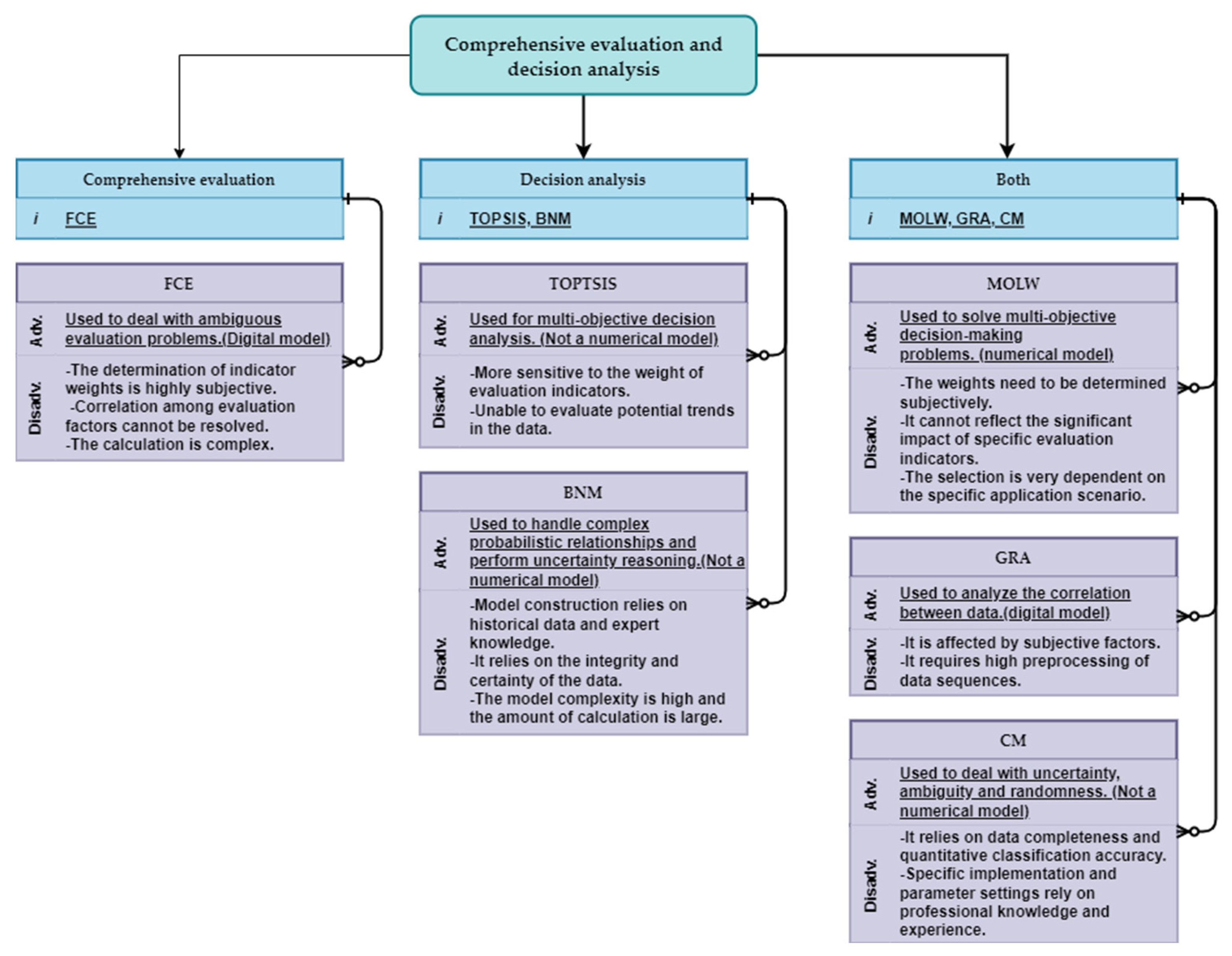
4.2.2. Grey Relational Analysis (GRA)

The GRA serves as a quantitative method for analyzing and comparing the developmental dynamics and changes within a system. It evaluates the degree of similarity between a continuous sequence and a reference sequence to establish the connection between the reference data sequence and several comparative data sets. The similarity in the shape of these sets is leveraged to assess how closely they are related, which reflects the correlation level between the curves and facilitates the establishment of spatial variable weights. A sequence that closely matches the reference data indicates a higher affiliation with that particular level, leading to an increased correlation coefficient [127]. In the framework of GSEUUS, the GRA method proves particularly effective in determining correlation coefficients among a variety of indicators. By multiplying the correlation coefficients obtained from different indicators with the predefined spatial variable weights, the criterion for maximum correlation can be utilized to evaluate the suitability of each unit within the 3D geological model [111]. The GRA evaluation process involves several steps: initially, recognizing the parent sequence that represents the behavioral characteristics of the system alongside the sub-sequences comprising factors that impact this behavior; thereafter, performing data preprocessing to lessen the influences of varying dimensions and data scales; following this, calculating the correlation coefficient by identifying the minimum and maximum differences at two levels and incorporating these figures into the correlation coefficient equation; next, deriving the correlation degree, which is the average of the correlation coefficients, to indicate the relationship between every sub-sequence and the parent sequence; finally, organizing or thoroughly evaluating based on the correlation degree to determine each factor’s impact on the target factor.
Figure 8. Application of main comprehensive evaluation and decision analysis: (a) [70]; (b) [106]; (c) [128]; (d) [51]; (e) [129]; (f) [67].
Applsci 15 04326 g008
GRA serves as a method for data evaluation that proficiently handles systems marked by a lack of complete information. The main benefit of this approach is its capability to navigate issues related to limited data sizes and considerable uncertainty. By computing correlations among sequences, this method uncovers the dynamic interrelations between variables, making it especially appropriate for situations with small sample sizes and insufficient information systems. Nonetheless, the correlation computation can be affected by subjective elements, including the choice of resolution coefficients, and necessitates comprehensive preprocessing of data sequences. Different preprocessing techniques may result in significant variations in the outcomes [48] (Figure 7).
In Nanjing, researchers employed the GRA along with the EWM and an interval continuous mathematical model to determine evaluation indicators and compute their corresponding weights [130]. Furthermore, the GRA can improve the technique for order preference by similarity to ideal solution (TOPSIS). The revised TOPSIS model maintains the advantages of enhanced objectivity while utilizing gray correlation theory, especially in situations where information is scarce [52]. In Foshan, the enhanced GRA was utilized to transform the reference sequence into a reference interval and to redefine the correlation coefficient function, thereby facilitating a more accurate evaluation of each assessment unit’s suitability [74]. This implementation not only increases the evaluation accuracy but also makes GRA more effective and practical for GSEUUS. (Figure 8d and Table 1)

4.2.3. Technique for Order Preference by Similarity to Ideal Solution (TOPSIS)

The TOPSIS model serves as a method for decision-making that depends on a limited set of evaluations to determine how well an object corresponds with a specified objective [131]. The core principle behind this approach lies in ranking evaluation objects according to their proximity to both positive and negative ideal outcomes. As a technique for multi-objective decision analysis, it is widely utilized in GSEUUS. By establishing both ideal and anti-ideal solutions, the TOPSIS method enables a structured assessment of UUS development amidst varying geological contexts, thus laying a scientific foundation for urban planning and construction activities. The evaluation procedure starts with the normalization of the initial data matrix, considering both positive and negative ideal scenarios. Next, the distances that each evaluation item has from these ideal solutions, both positive and negative, are computed to assess their proximity to the ideal solution. Ultimately, the strengths and weaknesses are prioritized according to their level of proximity [132].
The TOPSIS model’s benefit is found in its capacity to efficiently handle multi-criteria decision-making challenges by assessing each option according to its proximity to the ideal positive and negative solutions. It is user-friendly, simple to grasp, and uncomplicated to calculate. On the other hand, a significant drawback is its susceptibility to the importance assigned to evaluation criteria; the reasonableness of weight allocation directly affects the results of the decision-making process. Conventional TOPSIS uses Euclidean distance as its measurement standard, which might not fully reflect the underlying trends within the evaluation data, consequently influencing the accuracy of the assessment (Figure 7).
The TOPSIS method was utilized for evaluating the multi-layered UUS of Wuhan [70]. This evaluation involved the creation of a foundational layer assessment index system and a multi-layer transfer coefficient matrix, alongside the fuzzy analytic hierarchy process (FAHP) method to determine the significance of the evaluation indicators. A quantitative analysis of the UUS in the Wuchang Railway Station vicinity was then performed. In another analysis regarding the geological appropriateness of UUS in Hangzhou [133], the author applied an enhanced TOPSIS model, which was supplemented by gray correlation analysis, to identify implicit change patterns in the indicators and support the examination of data distribution under diverse informational contexts. This strategy effectively mitigates the disadvantages of Euclidean distance and addresses the inherent limitations found within the TOPSIS model itself (Figure 8a and Table 1).

4.2.4. Fuzzy Comprehensive Evaluation (FCE)

The FCE method is based on fuzzy mathematics and utilizes the concept of fuzzy relationship synthesis to measure factors that lack clear boundaries and are difficult to quantify. This method quantifies fuzzy indicators that pertain to the entities under evaluation (i.e., it assesses the degree of membership) by creating hierarchical fuzzy subsets, followed by applying the fuzzy transformation principle to consolidate each indicator. It proves highly applicable in tackling non-deterministic challenges and improves the efficiency of addressing non-quantitative matters. By converting these hard-to-quantify elements into numerical evaluations, the FCE method allows for a more logical appraisal of GSEUUS. The procedure commences with identifying the evaluation objects and factors, defining evaluation levels, and forming a fuzzy relationship matrix through single-factor assessments. Afterward, the weights for each factor are established, and a synthesis operation is executed on the weight vector alongside the fuzzy relationship matrix to produce a comprehensive evaluation outcome, which is subsequently analyzed and interpreted based on the results obtained.
The FCE method presents various benefits, such as the capacity to handle fuzzy evaluation elements, deliver comprehensive evaluation data, and exhibit significant applicability to both subjective and objective variables. Nevertheless, it is accompanied by certain drawbacks, including intricate calculations and a somewhat subjective approach to defining the index weight vector. Furthermore, despite its robustness, the method faces challenges in handling the correlation issue among evaluation elements. When the index set is extensive, a super-fuzzy phenomenon may occur, which can ultimately affect the precision of the evaluation outcomes (Figure 7).
Numerous studies have explored the use of the FCE method for the GSEUUS. A 3D evaluation of rock mass quality is accomplished by refining the FCE method, which enhances the accuracy and reliability of the assessment [51]. Comparable approaches have been utilized for the suitability evaluation of UUS development in Ningbo [134]. When evaluating UUS’s suitability for development and use, the integration of the cloud model with the analytic hierarchy process effectively addresses the ambiguity and uncertainty present in the evaluation process [135]. In assessing the appropriateness of UUS development in Qingdao’s main urban area, an index system incorporating rock and soil features, groundwater, and geological structure was established, producing scientifically valid zoning outcomes via the fuzzy comprehensive evaluation method which provides a crucial basis for effective UUS development and use [128]. Overall, these investigations illustrate the efficacy and practical utility of the fuzzy comprehensive evaluation method in the context of assessing UUS development and utilization (Figure 8c and Table 1).

4.2.5. Cloud Model (CM)

The CM is based on the concepts of probability and statistics, providing a framework to tackle uncertainty and ambiguity by outlining the probability distribution of different states. When it comes to determining weights, the CM effectively mimics the fuzzy evaluations of experts regarding assessment indicators, highlighting the importance of each indicator through the computation of cloud parameters, like expectation, entropy, and super-entropy, thus aiding in weight determination. This method integrates the subjective insights and assessments of experts while also addressing the uncertainties and ambiguities that are intrinsic to the evaluation process. Additionally, the CM acts as a mathematical framework that captures complex systems marked by uncertainty and fuzziness. It converts qualitative descriptions into quantitative measures through the creation of membership functions, cloud functions, and cloud generation algorithms, facilitating the modeling and analysis of complicated systems. The CM is equipped with strong data processing and analytic functions, proficiently managing various complex data structures and associations, therefore laying a scientific groundwork for informed decision-making. Moreover, CM is capable of processing and analyzing extensive datasets to derive meaningful information and insights. In the field of supportive decision-making analysis, they provide a scientific foundation for decision-makers by simulating the probabilities and risks linked to different decision-making options.
The CM offers significant benefits in GSEUUS, primarily through its ability to incorporate randomness and fuzziness. This allows for a seamless transition between qualitative linguistic values and quantitative measurements, thereby improving both the precision and impartiality of the evaluation process. Particularly noteworthy is the model’s adeptness at handling the intrinsic fuzziness and uncertainty linked to the GSEUUS. Nonetheless, the CM has its drawbacks. Its efficacy can be affected by various factors, including data completeness and the accuracy of quantification and classification. Furthermore, the successful implementation and parameterization of the CM demand a certain level of specialized knowledge and expertise, which may influence the reliability and accuracy of the evaluation results (Figure 7).
The CM is widely used for GSEUUS [7] and analyzing slope stability [136]. The combination of the AHP with the CM significantly improves the process of determining the weights and certainty degrees associated with evaluation metrics [67]. By applying a limited interval in the CM, the randomness and fuzziness present in geological indicators are effectively tackled, which enhances the evaluations’ accuracy and objectivity [135]. Additionally, the genetic algorithm-based weighting method considers both subjective and objective weights, leading to evaluation results that are more rational and in better accordance with actual conditions [7] (Figure 8f and Table 1).

4.2.6. Bayesian Network Model (BNM)

The BNM serves as a statistical modeling instrument rooted in the principles of probability and graph theory. It consists of a directed acyclic graph coupled with a conditional probability table, both of which illustrate the conditional relationships among random variables in intricate systems. BNM is notably proficient in calculating posterior probability distributions for unobserved variables, integrating both quantitative and qualitative data into a conditional probability structure based on the observed variables (for instance, variables may include Boolean (yes/no), qualitative assessments (low/medium/high), or continuous measurements). This ability to represent different types of variables is an essential characteristic of BNs, which motivates our use of this methodology to assess system resilience [137]. In GSE, the BNM is utilized to anticipate possible alterations in suitability with varied input parameters, thus offering a scientific basis for the judicious development and use of underground environments. The BNM develops a structural framework to illustrate the relationships among various variables. It sets up prior and conditional probabilities grounded in geological survey data, subsequently using Bayesian inference to calculate the posterior probabilities of suitability for each assessment area across diverse categories. Upon completing the modeling process, it is essential to create the conditional probability table for the nodes. The first approach, data-driven training, is suitable for all measurable objective variables and necessitates training on comprehensive datasets. In contrast, the second approach depends on expert survey, facilitating the amalgamation of multi-source data [138] and the determination of the weight of each factor at every level through the AHP judgment matrix.
The BNM present a range of benefits, such as robust data mining functionalities, the combination of expert insights with data to navigate intricate relationships of uncertainty, and an intuitive framework for probabilistic reasoning and decision-making support [139,140,141]. Moreover, the BNM is capable of illustrating causal interactions between evaluation metrics and objectives [137,138]. Nevertheless, developing these models requires considerable historical data as well as specialized knowledge. In addition, they can be vulnerable to issues related to incomplete data and uncertainty, and the intricacies and computational demands associated with them may present obstacles in real-world applications [139] (Figure 7).
In GSEUUS within Changsha [129], Xu et al. meticulously formulated a system of indices that encompasses factors, like formation type, groundwater level, and soil strength, drawing on the relationships among these input variables. To support this analysis, a Bayesian network framework was established. Through the application of this Bayesian network model, the research provides a scientific basis for the prudent planning and development of subterranean space in Changsha City, thereby improving the accuracy and scientific integrity of urban planning decisions (Figure 8e and Table 1).
Table 1. The geological suitability evaluation of UUS and application in China.
Time of PublicationAuthorCityEvaluation IndexWeight EvaluationComprehensive Evaluation and Decision AnalysisEvaluation SystemNotes
2024Pu, Huang, Bi et al. [74]Foshan CityExisting ground restrictions, the structures on the ground, engineering geological and hydrogeological conditionsEWM, G1 methodGRA
2024Xu, Chen, Li et al. [135]Sanya Central Business DistrictTopography, geomorphology, rock and soil properties, hydrogeological factors, geological hazards, social and economic conditionsAHPCM, FCE In Chinese
2024Li, Yang, Luo et al. [126]Guian new areaTopography, engineering geology, environment geology, hydrogeology, water ecology, utilization of underground space, utilization of surface spaceAHP, Expert scoring method (ESM) ArcgisIn Chinese
2023Xu, Zhou, Zhang et al. [129]ChangshaSocioeconomic, geological condition, and the current construction statusAHPBNM
2023Deng, Pu, Huang et al. [67]Foshan CityEngineering geological conditions, hydrogeological conditions, and the bad geological problemAHPCM3D geological modeling
2022Dou, Xing, Li et al. [133]Future Sci-Tech City, HangzhouTopographic, geotechnical engineering properties, and hydrogeological conditionsANP, CRITICThe game theory(GT), GRA, TOPSIS3D Geomodeller software
2022Liu, Peng, Wu et al. [130]Jiangbei New District of NanjingCharacteristic value of bearing, capacity, cohesion, internal friction angle, compression modulus, water content, pore ratio, vertical permeability coefficient, horizontal permeability coefficientEWMGRA, Interval continuous mathematical model (ICMM)3D-Mine and ArcGIS
2022Chen, Chen, Guo et al. [142]NanjingNatural conditions, ground and underground space conditions, geographical location, economic conditions, development benefits, and policy compatibilityDelphi, AHP, EWM GIS, the multi-agent system (MAS) modelling
2022Peng, Su, Chen et al. [51]Chengdu Airport New TownCohesion, internal friction angle, Poisson’s ratio, saturated uniaxial compressive strength, and rock mass integrity coefficientAHPGRA, Super-standard multiple method (SSMM)
2021Dou, Li, Xing et al. [52]Qianjiang Newtown in HangzhouTopography, geotechnical engineering proper ties, hydrogeology, and spatial structure characteristics of geologic bodyAHPFCE3D Geomodeller software
2021Tan, Wang, Jiao et al. [7]Wuhan Changjiang New TownTopography and geomorphology, geotechnical characteristics, geological structure, hydrogeological conditions, adverse geological phenomenaAHP, EWM, CRITICCM, Genetic algorithm (GA)
2021Zhang, Zhu, Liao et al. [143]Luohu District, ShenzhenTopography, hydrogeology, engineering geology, environmental geology, ground surface usage status, and underground space usage statusAHPThe most unfavorable grading method (MUGM) and the exclusive method (EM)Artificial intervention genetic algorithm(AIGA)
2020Zhang, Wang, Dong et al. [9]Xi’anImportant historical sites and cultural relics, strategic reserve, existing facility, active fault, ground fissures, land subsidence, collapsible loess, sand liquefaction, groundwater corrosion, wet land river or lake, and gravel The negative list method (NLM)
2020Kapoor, Jain and Bansal [113]Pradesh, IndiaSlope, soil type, elevation, accessibility, vegetation, surface runoff, land use, aspect, groundwater table, and existing utilitiesAHP, ESM ArcGIS
2020Nyimbili, Erden [36]IstanbulHigh population density, proximity to main roads, distance from existing fire stations, liquid petroleum gases, wooden building density, and distance to earthquake riskAHP, EWM GIS
2020Ustaoglu, Aydınoglu [123]IstanbulGeo-physical attributes, accessibility, built-up area and infrastructure, vegetation, and green and blue amenitiesAHP, EWM GIS
2019Zhou, Li, Wang et al. [106]NantongGeological conditions, existing facilities and various, socio-economic factorsAHP, ESMMOLWGIS
2019Xia, Dong, He et al. [128]QingdaoLandform, engineering geology, hydrogeology, adverse geological processes, and human factorsAHP, ESMFCE In Chinese
2018Peng, Peng [114]Tongren and ChangzhouLandforms, engineering geology, hydrogeology, site stability, existing subsurface construction conditions, urban location, and land useAHPMUGM, EMGIS software and ArcGIS 10.2
2017Aburas, Abdullah, Ramli, et al. [144]Seremban MalaysiaElevation, slope, soil texture, population density, land cover, distance to roads, highways, railways, powerlines, streams, industrial, residential, commercial, and educational areasAHP GIS
2016Lu, Wu, Zhuang et al. [70]Wuchang Railway StationGeotechnical properties of under-layers, geological structure, geomorphology conditions, hydrogeological conditions, and adverse environmental geological problemsAHPTOPSIS, Fuzzy set theory (FST)
2016Zhu, Huang, Li et al. [30]ChangzhouTopography and landforms, engineering geology, hydrogeology, site stability, and urban construction conditionsAHP, ESMMUGMthe digital underground space and engineering platform
2016Hou, Yang, Deng et al. [11]FoshanSoil condition, bedrock condition, fault activity, and levelAHP, EWMFST3D Voxel
2016Hu, Liu, Tao [134]NingboHydrogeological conditions, engineering geological conditions, environmental geological problems, economic, and technicalAHP, ESMFCE In Chinese
2011Youssef, Pradhan [112]EgyptLand use/cover, geological, geomorphological, geophysical, environmental, remote sensing, and field dataAHP GIS software

5. Problems and Suggestions for Improvement

5.1. The Choice of Evaluation Index

GSEUUS is a multifaceted task that should be dynamic rather than fixed. The evaluation process must be customized according to the specific evaluation goals, geological circumstances, resource availability, unique aspects of the geological setting, geological hazards, and the presence of existing constructions in the area being examined. The qualitative selection of criteria for assessment should not only meet the evaluation standards but also accurately depict the distinctive features of the study region. For example, in the evaluation of coastal cities, it is crucial to take into consideration the detrimental impacts of seawater intrusion on both soil and water. In soft soil areas near the coast, the challenges associated with this type of sediment must also be acknowledged. Additionally, concerns pertaining to water resources and pollution need to be resolved in accordance with particular conditions of the research. Groundwater exemplifies a resource that possesses both beneficial attributes and geological disaster characteristics, which can restrict underground development. The presence of groundwater often inhibits alternative uses of subterranean spaces [68]. When the policy foundation for UUS development is centered on maximizing profits while minimizing disadvantages, contradictions may arise in the interpretation of evaluation results. The variations in engineering geological formations can also affect the feasibility of developing USR. Therefore, it is essential that the chosen evaluation criteria are both logical and anchored in scientific principles. This consideration is also a significant point of emphasis for review experts.

5.2. Rationalization of Weights

The process of selecting weights should be conducted with a rigor that not only corresponds to established evaluative frameworks but also adheres to core developmental principles.
Among the methods for subjective weighting, both the ESM and the Delphi method are widely utilized. When data is scarce or difficult to quantify, such as in the evaluation of cultural heritage protection, or when it is necessary to integrate expertise from multiple fields or in policy-driven planning, subjective weight determination methods are often employed. However, these subjective weights are influenced by the selection preferences of experts, which can lead to significant biases [145]. Furthermore, consistency testing of these weights is relatively challenging, as well as being time-consuming and labor-intensive. On the other hand, objective weighting methods commonly include the AHP, EWM, and the TOPSIS. Objective weight evaluation necessitates sufficient and high-quality data, aiming to minimize the influence of subjective factors. For instance, when the relationships among indicators are complex, quantitative analysis becomes essential. However, objective weight evaluation is not without its shortcomings. It tends to amplify sensitivity to outliers and may overlook the semantic significance of indicators, and static weights fail to dynamically adapt to environmental changes.
By combining these methodologies, one can effectively apply expert insights along with data objectivity, thus improving the accuracy and reasonableness of GSE [114,146]. Recent investigations have witnessed ongoing improvements in weight determination techniques, particularly through enhanced versions of AHP and TOPSIS, which now integrate both subjective and objective weight elements to refine the accuracy and rationale of the evaluations further [52,147]. Evaluating the reasonableness of weights is a vital part of this methodology, with the robustness and credibility of weights subject to further examination using methods, such as consistency checks and sensitivity analysis. Recent studies have increasingly adopted AI-driven and hybrid methods (e.g., machine learning techniques, like random forests and Bayesian networks) to address subjective weight assignments by analyzing historical data and automating weight optimization. [148].

5.3. Solve Problems at the Layer

When a single-layer UUS lacks sufficient capacity to meet demands, it becomes essential to explore multi-layer UUS solutions to align with urban growth [52]. Assessing the suitability of UUS involves acknowledging multiple layers for UUS development and utilization, which require different selection criteria and factor weighting. The notion of hierarchical combination was introduced [149,150], facilitating the reduction of multi-layer assessments into a single layer but neglecting the differences in vertical distribution. Although this approach can yield a rough assessment of the significance of geological factors during the initial phases and near-surface development of urban underground areas, it is crucial to take into account how the upper layers impact the bottom layer, particularly under deeper and prolonged conditions. Geological modeling technologies play a vital role in analyzing geological body properties, illustrating sectional models, and showcasing internal and stratigraphic distributions.

5.4. Solve the Problem of Heterogeneity

Evaluations conducted in 2D fall short in effectively merging UUS geological data with the intrinsic 3D characteristics or complicated spatial configurations, which frequently leads to a decline in depth information. By partitioning the UUS into multiple vertical underground spatial layers [151,152], a quasi-3D assessment can be achieved. Various technologies, such as 3D geological modeling, 3D-GIS, and Building Information Modeling (BIM), are extensively utilized during the phases of urban planning, construction, maintenance, and management [153], thus promoting the progression of 3D geological assessments. Additionally, 3D techniques, such as the 3D spatial data model and sagittal integration modeling technology, have been employed to evaluate the geological appropriateness of UUS planning [67,133,154]. The intricacy of 3D geological modeling largely arises from the necessity to align strata with geological principles, especially in areas with extensive sedimentary cover. The challenge of simulating the 3D spatial arrangement of sedimentary layers utilizing drilling and geophysical data becomes pronounced, particularly at smaller scales (less than 1:50,000). Given the non-homogeneous and anisotropic characteristics of formations, relying solely on borehole data proves inadequate for precisely identifying the dimensions of minor geological formations. Moreover, geophysical interpretation outcomes can appear somewhat unrealistic without thorough verification through detailed drilling data, which can result in poor accuracy regarding the inferred vertical stratigraphic arrangement. Additionally, the difficulty in assessing the suitability of 3D geological models stems from the need to effectively capture the planar and layered variability of each parameter, which is crucial for accurately representing the true geological, engineering geological, hydrogeological, and environmental geological contexts [69]. The spatial variable weight allocation technique is notably beneficial for performing 3D-GSE [74]. The diversity of underground infrastructure necessitates a shift from generic models to customized frameworks in geological suitability assessments, thereby completely breaking the constraints of stratum homogeneity. For instance, energy facilities require enhanced deep geological exploration, while municipal facilities necessitate high-density shallow geotechnical testing. To meet this demand, future research should establish a facility-geology matching database to support the automatic recommendation of assessment indicators. Concurrently, a modular weighting system should be developed that allows users to load predefined parameters based on facility types. Furthermore, exploring digital twin technology could simulate the long-term performance of different facilities under dynamic geological conditions, such as conducting century-scale settlement predictions. The applications of 3D geological modeling technology in the development and utilization of UUS are numerous. For example, the Kunming GSEUUS proposed an innovative 3D-CWC framework that integrates the weighted cloud model with 3D geological modeling to address vertical complexity and uncertainty in geological assessments [155]. In Xuzhou’s 3D geological modeling, a regional modeling method based on overlay integration technology was utilized [156].

5.5. Integration of Evaluation Results and DSS

The integration of rating results and DSS relies not only on the evaluations themselves but also on the compatibility of the decision-making systems. The EU SEA Directive 2001/42/EC, recognized as an international benchmark, explicitly mandates that public planning and plans systematically assess their potential impacts on the environment, biodiversity, and cultural heritage during the initial formulation stage, while also incorporating public participation mechanisms. This regulation not only establishes the evaluation logic of “prevention is better than treatment” but also facilitates the transformation of land use from extensive expansion to refined governance through key processes, such as “alternative scheme analysis” and “cumulative effect evaluation.” With the advancement of international initiatives, like the “European Green Deal,” [157] ESA will further transition from “passive compliance” to “active innovation,” promoting the evolution of GSEUUS from “climate adaptation design” to “nature symbiotic development.” This transition requires not only breakthroughs in technical methods but also global policy coordination; only by deeply embedding the core concepts of ESA into the land use planning system can a long-term balance between underground resource development and the community of life on Earth be achieved.

6. The Case (Xiong’an New Area, China)

6.1. The Concept of Development

The concept of UUS development in the Xiong’an New Area emphasizes the principle of “first underground, then above ground,” highlighting the importance of rational development and utilization of UUS in the planning and construction of the area. The “Outline of Xiong’an new area planning in Hebei province” explicitly states the need to “actively utilize shallow layers, sub-shallow space, and, if feasible, make use of sub-deep space while flexibly reserving deep space.” In constructing the UUS structure of the Xiong’an New Area, a comprehensive consideration of the engineering geological structure and hydrogeological conditions was undertaken. Consequently, the UUS development and utilization was categorized into four layers: shallow layer (L1: 0 to −30 m), sub-shallow layer (L2: −30 to −50 m), sub-deep layer (L3: −50 to −70 m), and deep layer (L4: −70 to −100 m) [2] (Figure 9). The selection of elements thoroughly assesses the characteristics of UUS, encompassing resources, ecological variables, and disaster-related factors. It mainly considers indicators, such as topography, engineering geological structures, foundational soil conditions, hydrological conditions, environmental geological issues, and dynamic geological impacts.

6.2. Suitability Evaluation

Numerous researchers have applied a variety of approaches to GSEUUS in the Xiong’an New Area from different viewpoints. Han [150] employed the AHP-CIM to examine the geological viability of shallow, sub-deep, and deep UUS. Liu et al. [2] proposed a combined evaluation method that integrates the EWM and CRITIC weighting, creating an evaluation index system for GSEUUS. This method factors in the variability, interrelations, and comparative strengths of the evaluation indicators, leading to a more logical and scientifically sound determination of weights. Gao et al. [146] developed a CM for GSE in the Xiong’an New Area, grounded in the EWM analysis method, while comprehensively considering variables that affect urban development suitability, including geological conditions, groundwater status, and environmental geological concerns (Figure 10). This methodology improves the quantification of the weights of evaluation factors, enhancing both the accuracy and dependability of the evaluation outcomes.
Through a scientific assessment of geological factors, the safety, sustainability, and rationality of developing UUS can be assured, while it is possible to reduce the potential risks linked to geological aspects [5,25]. An GSE clarifies the geological conditions and developmental potential across various areas, offering scientific insights for the spatial organization and functional zoning of the Xiong’an New Area, thereby promoting harmonious regional growth. This method aids in preventing unrestrained development and illogical utilization of UUS resources, which in turn supports the sustainable advancement of Xiong’an New Area and achieves equilibrium among economic, social, and environmental benefits. By encouraging the thoughtful development and use of UUS, the urban resilience of Xiong’an New Area can be strengthened, leading to the enhanced capacity of the city to manage natural disasters and emergencies, thereby ensuring safety and stable operations. As a nationally designated new area, the planning and development of Xiong’an New Area is of considerable significance. The outcomes of this research not only bolster the planning and construction endeavors of Xiong’an New Area but also offer valuable insights and models that can inform the development and utilization of UUS in other urban areas.
Figure 10. Concept map of urban engineering construction suitability evaluation based on entropy weight hierarchical cloud model [146].
Applsci 15 04326 g010
SEA has been effectively applied in the development of the Xiong’an New Area. The planning of its UUS adheres strictly to SEA principles. It dynamically integrates geological suitability evaluation indicators, such as soil layer bearing capacity and sand layer liquefaction index, with environmental strategic goals, including carbon neutrality and the protection of biological corridors. This approach has led to the construction of the world’s first multi-objective optimization model that encompasses ’geology–ecology–energy.’ [158,159] In subsequent work, the weight ratio of geological factors to environmental factors should be dynamically adjusted. For ecological redline zones, it is essential to significantly elevate the priority of environmental factors. When evaluating the environmental carrying capacity of the Xiong’an New Area, it is crucial to consider not only conventional conditions and ecological redline zones but also the impact of inter-basin water transfer.

7. Conclusions

The GSEUUS is a vital component in guaranteeing the safe and sensible development of these spaces. By creating an evaluation index system grounded in scientific principles and choosing suitable assessment techniques, one can accurately gauge the geological conditions and potential for development across different regions. Nevertheless, various challenges remain in existing evaluation methodologies and technologies. These include a lack of standardized criteria for selecting evaluation metrics, considerable subjectivity in methods for determining weights, and the intricacies involved in multi-layered or 3D assessments. To address these issues, it is crucial to improve research focused on the scientific credibility and rationale of evaluation metrics, explore more objective and precise techniques for weight assignment, and promote the use of 3D geological modeling in suitability assessments. The diversity of underground infrastructure necessitates a transition from a ’generic model’ to a ’customized framework’ for assessing geological suitability. Furthermore, developing customized evaluation criteria and guidelines that reflect the unique conditions of individual urban areas is essential for enhancing the relevance and applicability of these evaluations. GSEUUS encompasses multiple disciplines and presents a broad array of application scenarios. The GSE evaluation method can also serve as a reference for other areas of work, including engineering construction suitability evaluation and resource and environmental carrying capacity assessment. This versatility positions it as a potential application scenario, thereby enhancing its overall value. By persistently improving the technical approaches for evaluating geological suitability, we can support the orderly and rational development of UUS, thus contributing to sustainable urban growth.

Author Contributions

Conceptualization, Y.X. and H.L.; methodology, Y.X., H.L., Y.G. and B.H.; formal analysis, Y.X. and J.Z.; resources, J.L.; writing—original draft preparation, Y.X.; writing—review and editing, Y.X. and J.T.; supervision, M.Z. and S.H.; project administration, J.T. and J.Z.; funding acquisition, J.L. All authors have read and agreed to the published version of the manuscript.

Funding

This research was funded by the Hebei Bureau of Geology and Mineral Resources Exploration, grant number 13000024P00329410267M.

Conflicts of Interest

The authors declare no conflicts of interest.

References

  1. Cohen, B.; Muñoz, P. Sharing cities and sustainable consumption and production: Towards an integrated framework. J. Clean. Prod. 2016, 134, 87–97. [Google Scholar] [CrossRef]
  2. Liu, H.W.; Li, Z.; He, Q.C. Suitability Assessment of Multilayer Urban Underground Space Based on Entropy and CRITIC Combined Weighting Method: A Case Study in Xiong’an New Area, China. Appl. Sci. 2023, 13, 10231. [Google Scholar] [CrossRef]
  3. Zhang, Y.Q.; Chen, Z.J.; Cheng, Q.W.; Zhou, C.; Jiang, P.H.; Li, M.C.; Chen, D. Quota Restrictions on Land Use for Decelerating Urban Sprawl of Mega City: A Case Study of Shanghai, China. Sustainability 2016, 8, 968. [Google Scholar] [CrossRef]
  4. Liu, D.X.; Wu, L.X.; Yang, Y. A Hybrid Weight Assignment Model for Urban Underground Space Resources Evaluation Integrated with the Weight of Time Dimension. Appl. Sci. 2020, 10, 5152. [Google Scholar] [CrossRef]
  5. Sterling, R.; Admiraal, H.; Bobylev, N.; Parker, H.; Godard, J.-P.; Vähäaho, I.; Rogers, C.D.F.; Shi, X.D.; Hanamura, T. Sustainability issues for underground space in urban areas. Urban Des. Plan. 2012, 165, 241–254. [Google Scholar] [CrossRef]
  6. Bobylev, N.; Sterling, R. Urban Underground Space: A Growing Imperative Perspectives and Current Research in Planning and Design for Underground Space Use. Tunn. Undergr. Space Technol. 2016, 55, 1–4. [Google Scholar] [CrossRef]
  7. Tan, F.; Wang, J.; Jiao, Y.Y.; Ma, B.C.; He, L.L. Suitability evaluation of underground space based on finite interval cloud model and genetic algorithm combination weighting. Tunn. Undergr. Space Technol. 2021, 108, 103743. [Google Scholar] [CrossRef]
  8. Peng, J.W.; Peng, F.L.; Yabuki, N.; Fukuda, T. Factors in the development of urban underground space surrounding metro stations: A case study of Osaka, Japan. Tunn. Undergr. Space Technol. 2019, 91, 103009. [Google Scholar] [CrossRef]
  9. Zhang, M.S.; Wang, H.Q.; Dong, Y.; Li, L.; Sun, P.P.; Zhang, G. Evaluation of urban underground space resources using a negative list method: Taking Xi’an city as an example in China. China Geol. 2020, 3, 124–136. [Google Scholar] [CrossRef]
  10. Peng, L.Y.; He, L.; Zhang, Y.; Zhou, Y.X.; Xiao, H.G.; Wang, R.H. Planning urban underground space from urban emergency evacuation: A digital layout planning method. Tunn. Undergr. Space Technol. 2023, 140, 105271. [Google Scholar] [CrossRef]
  11. Hou, W.S.; Yang, L.; Deng, D.C.; Ye, J.; Clarke, K.; Yang, Z.J.; Zhuang, W.M.; Liu, J.X.; Huang, J.C. Assessing quality of urban underground spaces by coupling 3D geological models: The case study of Foshan city, South China. Comput. Geosci. 2016, 89, 1–11. [Google Scholar] [CrossRef]
  12. Bobylev, N. Mainstreaming sustainable development into a city’s Master plan: A case of Urban Underground Space use. Land Use Policy 2009, 26, 1128–1137. [Google Scholar] [CrossRef]
  13. Krzeminska, A.; Zareba, A.; Dzikowska, A.; Kazmierczak, B.; Kutylowska, M.; Piekarska, K.; Jouhara, H.; Danielewicz, J. Bioarchitecture—A new vision of energy sustainable cities. In Proceedings of the International Conference on Advances in Energy Systems and Environmental Engineering (ASEE17), Wroclaw, Poland, 2–5 July 2017; p. 22. [Google Scholar]
  14. Levinson, D.M.; Giacomin, D.; Badsey-Ellis, A. Accessibility and the choice of network investments in the London Underground. J. Transp. Land Use 2016, 9, 131–150. [Google Scholar] [CrossRef]
  15. Matsuo, I. Special Issue on Comprehensive Disaster Prevention Measures for Underground Spaces (Underground Malls, etc.). J. Disaster Res. 2016, 11, 273. [Google Scholar] [CrossRef]
  16. Guo, X. Research on the Resilience Evaluation and Promotion Strategy of Urban Underground Space. Nat. Resour. Econ. China 2023, 36, 74–81. [Google Scholar] [CrossRef]
  17. Xie, L.P.; Luo, J.Z.; Zhou, Y.L. Urban Underground Space Development and Utilization and Environmental Geological Effect in Wuhan. Environ. Sci. Technol. 2009, 32, 209–214. (In Chinese) [Google Scholar] [CrossRef]
  18. Wang, L.; Li, H.; Wang, D.H.; Zhou, S.; Zhang, W.; Long, X.; Yang, J.; Wang, Q. Urban geophysical exploration: Case study in Chengdu International Bio-City. J. Geophys. Eng. 2023, 20, 830–840. [Google Scholar] [CrossRef]
  19. Carmody, J.; Sterling, R. Underground Space Design: A Guide to Subsurface Utilization and Design for People in Underground Spaces; Van Nostrand Reinhold Press: New York, NY, USA, 1993. [Google Scholar]
  20. Durmisevic, S. The future of the underground space. Cities 1999, 16, 233–245. [Google Scholar] [CrossRef]
  21. Pucker, J.; Allouche, E.N.; Sterling, R.L. Social Costs Associated with Trenchless Projects: Case Histories in North American and Europe. In Proceedings of the 2006 NASTT No-Dig Conference, Nashville, TN, USA, 26–28 March 2006; Paper C-4-04. NASTT: Arlington, VA, USA, 2006. [Google Scholar]
  22. Bartel, S.; Janssen, G. Underground spatial planning—Perspectives and current research in Germany. Tunn. Undergr. Space Technol. 2016, 55, 112–117. [Google Scholar] [CrossRef]
  23. Godard, J.P. Urban underground space and benefits of going underground. In Proceedings of the World Tunnel Congress 2004 and 30th ITA General Assembly, Singapore, 22–27 May 2004. [Google Scholar]
  24. Hunt, D.V.L.; Nash, D.; Rogers, C.D.F. Sustainable utility placement via multi-utility tunnels. Tunn. Undergr. Space Technol. 2014, 39, 15–26. [Google Scholar] [CrossRef]
  25. Hunt, D.V.L.; Rogers, C.D.F. Barriers to sustainable infrastructure in urban regeneration. Proc. Inst. Civ. Eng.-Eng. Sustain. 2005, 158, 67–81. [Google Scholar] [CrossRef]
  26. Hunt, D.V.L.; Jefferson, I.; Rogers, C.D.F. Assessing the sustainability of underground space usage—A toolkit for testing possible urban futures. J. Mt. Sci. 2011, 8, 212–222. [Google Scholar] [CrossRef]
  27. Serrano-Juan, A.; Pujades, E.; Vázquez-Suñè, E.; Crosetto, M.; Cuevas-González, M. Leveling vs. InSAR in urban underground construction monitoring: Pros and cons. Case of la sagrera railway station (Barcelona, Spain). Eng. Geol. 2017, 218, 1–11. [Google Scholar] [CrossRef]
  28. Chen, J.; Jia, W.; Zhang, Y.; Lin, J. Integrated TEM and GPR data interpretation for high-resolution measurement of urban underground space. IEEE Trans. Instrum. Meas. 2021, 71, 5004409. [Google Scholar] [CrossRef]
  29. Viggiani, G. Geotechnical Aspects of Underground Construction in Soft Ground; CRC Press: Boca Raton, FL, USA, 2012. [Google Scholar] [CrossRef]
  30. Zhu, H.; Huang, X.; Li, X.; Zhang, L.; Liu, X. Evaluation of urban underground space resources using digitalization technologies. Undergr. Space 2016, 1, 124–136. [Google Scholar] [CrossRef]
  31. Broere, W. Urban underground space: Solving the problems of today’s cities. Tunn. Undergr. Space Technol. 2016, 55, 245–248. [Google Scholar] [CrossRef]
  32. Attanayake, P.M.; Waterman, M.K. Identifying environmental impacts of underground construction. Hydrogeol. J. 2006, 14, 1160–1170. [Google Scholar] [CrossRef]
  33. Vähäaho, I. Underground space planning in Helsinki. J. Rock Mech. Geotech. Eng. 2014, 6, 387–398. [Google Scholar] [CrossRef]
  34. Kalnay, E.; Cai, M. Impact of urbanization and land-use change on climate. Nature 2003, 423, 528–531. [Google Scholar] [CrossRef]
  35. Wang, Y.; Peng, F.L. Evaluation of urban underground space based on the geological conditions: A feasibility study. New Front. Geotech. Eng. 2014, 187–197. [Google Scholar] [CrossRef]
  36. Nyimbili, P.H.; Erden, T. A Hybrid Approach Integrating Entropy-AHP and GIS for Suitability Assessment of Urban Emergency Facilities. ISPRS Int. J. Geo-Inf. 2020, 9, 419. [Google Scholar] [CrossRef]
  37. Price, S.J.; Terrington, R.L.; Busby, J.; Bricker, S.; Berry, T. 3D ground-use optimisation for sustainable urban development planning: A case-study from Earls Court, London, UK. Tunn. Undergr. Space Technol. 2018, 81, 144–164. [Google Scholar] [CrossRef]
  38. Rönkä, K.; Ritola, J.; Rauhala, K. Underground space in land-use planning. Tunn. Undergr. Space Technol. 1998, 13, 39–49. [Google Scholar] [CrossRef]
  39. Admiraal, H.; Cornaro, A. Why underground space should be included in urban planning policy–And how this will enhance an urban underground future. Tunn. Undergr. Space Technol. 2016, 55, 214–220. [Google Scholar] [CrossRef]
  40. National Research Council. Underground Engineering for Sustainable Urban Development; National Academies Press: Washington, DC, USA, 2013. [Google Scholar] [CrossRef]
  41. Therivel, R. Strategic Environmental Assessment in Action; Routledge: London, UK, 2012. [Google Scholar]
  42. Lee, N.; Walsh, F. Strategic environmental assessment: An overview. Proj. Apprais. 1992, 7, 126–136. [Google Scholar] [CrossRef]
  43. Thérivel, R.; Partidário, M.R. The Practice of Strategic Environmental Assessment; Earthscan: London, UK, 1996. [Google Scholar]
  44. Fischer, T.B. The Theory and Practice of Strategic Environmental Assessment: Towards a More Systematic Approach; Earthscan: Oxford, UK; Barcelona, CA, USA, 2007. [Google Scholar]
  45. Gao, Y.H.; Shen, J.H.; Chen, L.; Li, X.; Jin, S.; Ma, Z.; Meng, Q.H. Influence of underground space development mode on the groundwater flow field in Xiong’an new area. J. Groundw. Sci. Eng. 2023, 11, 68–80. [Google Scholar] [CrossRef]
  46. Li, W.; Lu, K.; Li, H.; Cui, H.; Li, X. New multi-resolution and multi-scale electromagnetic detection methods for urban underground spaces. J. Appl. Geophys. 2018, 159, 742–753. [Google Scholar] [CrossRef]
  47. Shao, F.; Wang, Y. Intelligent overall planning model of underground space based on digital twin. Comput. Electr. Eng. 2022, 104, 108393. [Google Scholar] [CrossRef]
  48. Ni, X.; Li, J.; Xu, J.; Shen, Y.; Liu, X. Grey relation analysis and multiple criteria decision analysis method model for suitability evaluation of underground space development. Eng. Geol. 2024, 338, 107608. [Google Scholar] [CrossRef]
  49. The Central Committee of the Communist Party of China. The 14th Five Year Plan for National Economic and Social Development of the People’s Republic of China and the Long Range Objectives for 2035; People’s Publishing House: Beijing, China, 2021.
  50. He, L.; Song, Y.; Dai, S.Z.; Durbak, K. Quantitative research on the capacity of urban underground space—The case of Shanghai, China. Tunn. Undergr. Space Technol. 2012, 32, 168–179. [Google Scholar] [CrossRef]
  51. Peng, Z.S.; Su, P.D.; Chen, W.Y.; Tao, H.J.; Ma, G.X.; Xia, Z.J.; Tang, B. 3D Quality Evaluation of Rock Mass in Urban Underground Space Based on Improved Fuzzy Analytic Hierarchy Process. KSCE J. Civ. Eng. 2022, 26, 4829–4839. [Google Scholar] [CrossRef]
  52. Dou, F.F.; Li, X.H.; Xing, H.X.; Yang, F.; Ge, W.Y. 3D geological suitability evaluation for urban underground space development—A case study of Qianjiang Newtown in Hangzhou, Eastern China. Tunn. Undergr. Space Technol. 2021, 115, 104052. [Google Scholar] [CrossRef]
  53. Liu, X.M. A detection method of urban underground geological anomalies in the United Kingdom based on feature fusion. Earth Sci. Res. J. 2022, 26, 255–262. [Google Scholar] [CrossRef]
  54. Zhao, J.W.; Peng, F.L.; Wang, T.Q.; Zhang, X.Y.; Jiang, B.N. Advances in master planning of urban underground space (UUS) in China. Tunn. Undergr. Space Technol. 2016, 55, 290–307. [Google Scholar] [CrossRef]
  55. Peng, J.W.; Peng, F.L. A GIS-based evaluation method of underground space resources for urban spatial planning: Part 1 methodology. Tunn. Undergr. Space Technol. 2018, 74, 82–95. [Google Scholar] [CrossRef]
  56. Ma, C.X.; Peng, F.L. Evaluation of spatial performance and supply-demand ratios of urban underground space based on POI data: A case study of Shanghai. Tunn. Undergr. Space Technol. 2023, 131, 104775. [Google Scholar] [CrossRef]
  57. Tann, L.V.D.; Sterling, R.; Zhou, Y.X.; Metje, N. Systems approaches to urban underground space planning and management—A review. Undergr. Space 2019, 5, 144–166. [Google Scholar] [CrossRef]
  58. Yuan, H.; He, Y.; Wu, Y.Y. A comparative study on urban underground space planning system between China and Japan. Sustain. Cities Soc. 2019, 48, 101541. [Google Scholar] [CrossRef]
  59. Lin, L.J.; Ma, Z.; Guo, X.; Zhang, Z.Y.; Li, Y.M. Research on basic theory of urban geology. Geol. China 2020, 47, 1668–1676, (In Chinese with English Abstract). [Google Scholar] [CrossRef]
  60. ISO 18504:2017; Soil Quality—Sustainable Remediation. International Organization for Standardization (ISO): Geneva, Switzerland, 2017.
  61. SEA Directive 2001/42/EC; Assessment of the Effects of Certain Plans and Programmes on the Environment. European Parliament and Council of the European Union: Brussels, Belgium, 2001.
  62. Zhao, P.D. Digital Geology, 1st ed.; Science Press: Beijing, China, 2024; p. 204. [Google Scholar]
  63. Kieu, Q.L.; Tran, D.V. Application of Geospatial Technologies in Constructing a Flash Flood Warning Model in Northern Mountainous Regions of Vietnam: A Case Study at TrinhTuong Commune, Bat Xat District, LaoCai Province; Bulletin of Geography; Physical Geography Series; Walter De Gruyter GmbH: Berlin, Germany, 2021; Volume 20, pp. 31–43. [Google Scholar] [CrossRef]
  64. Jajac, N.; Knezic, S.; Marovic, I. Decision Support System to Urban Infrastructure Maintenance Management. Organ. Technol. Manag. Constr. Int. J. 2009, 1, 72–79. Available online: https://hrcak.srce.hr/65018 (accessed on 25 February 2025).
  65. Partidário, M.R. Strategic Environmental Assessment Better Practice Guide—Methodological Guidance for Strategic Thinking in SEA; Agência Portuguesa do Ambiente e Redes Energéticas Nacionais: Lisboa, Portugal, 2012. [Google Scholar]
  66. Ma, Z.; Huang, Q.B.; Lin, L.J.; Zhang, X.; Han, B.; Xia, Y.B.; Guo, X. Practice and application of multi-factor urban geological survey in Xiong’an New Area. North China Geol. 2022, 45, 58–68. (In Chinese) [Google Scholar] [CrossRef]
  67. Deng, F.; Pu, J.; Huang, Y.; Han, Q. 3D geological suitability evaluation for underground space based on the AHP-cloud model. Undergr. Space 2023, 8, 109–122. [Google Scholar] [CrossRef]
  68. Parriaux, A.; Tacher, L.; Joliquin, P. The hidden side of cities—Towards three-dimensional land planning. Energy Build. 2004, 36, 335–341. [Google Scholar] [CrossRef]
  69. Xi, Y.; Li, X.J.; Zhu, H.H.; Zhang, W.B.; Zhao, S.C.; Xu, W.Y. Three-dimensional high-precision assessment of mountainous urban underground space resources: A case study in Chongqing, China. Tunn. Undergr. Space Technol. 2022, 123, 104439. [Google Scholar] [CrossRef]
  70. Lu, Z.L.; Wu, L.; Zhuang, X.Y.; Rabczuk, T. Quantitative assessment of engineering geological suitability for multilayer Urban Underground Space. Tunn. Undergr. Space Technol. 2016, 59, 65–76. [Google Scholar] [CrossRef]
  71. ASTM D420-18; Guidelines for Site Characterization Standards for Engineering Design and Construction Purposes. ASTM International: West Conshohocken, PA, USA, 2018.
  72. ISO 37120; Sustainable Development of Communities—Indicators for City Services and Quality of Life. International Organization for Standardization (ISO): Geneva, Switzerland, 2018.
  73. ISO 19650; Organization and Digitization of Information about Buildings and Civil Engineering Works, Including Building Information Modelling (BIM)—Information Management Using Building Information Modelling. International Organization for Standardization (ISO): Geneva, Switzerland, 2018.
  74. Pu, J.; Huang, Y.; Bi, Y.D.; Guo, Z.; Deng, F.; Li, X.Y.; Xu, C. 3D suitability evaluation of urban underground space using a variable weight method and considering ground restrictions. Undergr. Space 2024, 19, 208–226. [Google Scholar] [CrossRef]
  75. Liu, N.; Wan, Y.H.; Cao, C.Y.; Liu, X.Y. Innovative solutions for layout planning and implementation of a metro station and its accessory structures in mountainous cities, China. Tunn. Undergr. Space Technol. 2022, 129, 104670. [Google Scholar] [CrossRef]
  76. Si, Y.L.; Li, M.F.; Liu, Y.N.; Guo, W.H. One-dimensional constrained inversion study of TEM and application in coal goafs’ detection. Open Geosci. 2020, 12, 1533–1540. [Google Scholar] [CrossRef]
  77. Su, Y.J.; Cao, Z.N.; Zhao, G.X.; Hu, X.Y.; Fan, J.; Zhang, J.; Fan, C.S.; Huang, Z.F. Application of the high-density resistivity method in detailed exploration of superficial paleochannels in Xiong’an New Area. Geophys. Geochem. Explor. 2023, 47, 272–278. [Google Scholar] [CrossRef]
  78. Yu, P.; Liu, H.H.; Wang, Z.S.; Fu, J.N.; Zhang, H.; Wang, J.; Yang, Q. Development of urban underground space in coastal cities in China: A review. Deep Undergr. Sci. Eng. 2023, 2, 148–172. [Google Scholar] [CrossRef]
  79. Xia, Y.B.; Guo, X.; Wang, B.; Han, B.; Dou, Z.X. Study on the geological origin of groundwater and soil corrosivity in Xiong’an New Area. North China Geol. 2022, 45, 69–76. (In Chinese) [Google Scholar] [CrossRef]
  80. Teymen, A. Statistical models for estimating the uniaxial compressive strength and elastic modulus of rocks from different hardness test methods. Heliyon 2021, 7, e06891. [Google Scholar] [CrossRef] [PubMed]
  81. Mukhtar, A.; Yusoff, M.Z.; Ng, K.C. The potential influence of building optimization and passive design strategies on natural venti-lation systems in underground buildings: The state of the art. Tunn. Undergr. Space Technol. 2016, 92, 103065. [Google Scholar] [CrossRef]
  82. Li, X.Z.; Li, C.C.; Parriaux, A.; Wu, W.B.; Li, H.Q.; Sun, L.P.; Liu, C. Multiple resources and their sustainable development in Urban Underground Space. Tunn. Undergr. Space Technol. 2016, 55, 9–66. [Google Scholar] [CrossRef]
  83. Yu, G.P.; Zhang, Z.; Xu, T.; Li, X.L.; Wang, M.L.; Guo, X.; Xu, J.; Hou, J.; Guo, G.H.; Badal, J. The Urban Underground Space beneath the Karst Basin of Guilin, China, Revealed by Ambient Seismic Noise Tomography. Seismol. Res. Lett. 2022, 94, 172–188. [Google Scholar] [CrossRef]
  84. Yang, Z.H.; Lan, H.X.; Zhang, Y.S.; Gao, X.; Li, L.P. Nonlinear dynamic failure process of tunnel-fault system in response to strong seismic event. J. Asian Earth Sci. 2013, 64, 125–135. [Google Scholar] [CrossRef]
  85. Chen, S.P.; Zhou, X.H.; Tang, L.J.; Wang, Y.B.; Lv, D.Y.; Sun, M.S.; Qu, D.M. Wrench-related folding: A case study of Bohai Sea basin, China. Mar. Pet. Geol. 2010, 27, 179–190. [Google Scholar] [CrossRef]
  86. Jiang, W.J.; Wang, G.C.; Sheng, Y.Z.; Shi, Z.M.; Zhang, H. Isotopes in groundwater (2H, 18O, 14C) revealed the climate and groundwater recharge in the Northern China. Sci. Total Environ. 2019, 666, 298–307. [Google Scholar] [CrossRef]
  87. Xiao, Y.; Zhang, Y.Q.; Yang, H.J.; Wang, L.W.; Han, J.B.; Hao, Q.C.; Wang, J.; Zhao, Z.; Hu, W.X.; Wang, S.B.; et al. Interaction regimes of surface water and groundwater in a hyper-arid endorheic watershed on Tibetan Plateau: Insights from multi-proxy data. J. Hydrol. 2024, 644, 132020. [Google Scholar] [CrossRef]
  88. Heo, O.; Yoon, Y.; Do, J. Comparative Study of the Field Performances of Pressure-Grouted Micropiles Using Gravity and Packers. Appl. Sci. 2021, 11, 6736. [Google Scholar] [CrossRef]
  89. Luo, Q.X.; Zhang, D.; Lin, Q.H.; Yu, X.L.; Ma, C.Q.; She, Z.B. Unraveling the petrological enigma of the durability and corrosion resistance of ancient Roman concrete. Adv. Earth Sci. 2024, 39, 968–986. (In Chinese) [Google Scholar] [CrossRef]
  90. Jiang, W.J.; Sheng, Y.Z.; Shi, Z.M.; Guo, H.M.; Chen, X.L.; Mao, H.R.; Liu, F.T.; Ning, H.; Liu, N.N.; Wang, G.C. Hydrogeochemical characteristics and evolution of formation water in the continental sedimentary basin: A case study in the Qaidam Basin, China. Sci. Total Environ. 2024, 957, 177672. [Google Scholar] [CrossRef] [PubMed]
  91. Jiang, W.J.; Sheng, Y.Z.; Wang, G.C.; Shi, Z.M.; Liu, F.T.; Zhang, J.; Chen, D.L. Cl, Br, B, Li, and noble gases isotopes to study the origin and evolution of deep groundwater in sedimentary basins, a review. Environ. Chem. Lett. 2022, 20, 1497–1528. [Google Scholar] [CrossRef]
  92. Ning, H.; Jiang, W.J.; Sheng, Y.Z.; Wang, K.L.; Chen, S.M.; Zhang, Z.; Liu, F.T. Comprehensive evaluation of nitrogen contamination in water ecosystems of the Miyun reservoir watershed, northern China: Distribution, source apportionment and risk assessment. Env. Geochem. Health 2024, 46, 278. [Google Scholar] [CrossRef]
  93. Xia, Y.B.; Wang, B.; Yang, Y.S.; Du, X.Q.; Yang, M.X. Quantitative assessment of organic mass fluxes and natural attenuation processes in a petroleum-contaminated subsurface environment. Appl. Sci. 2023, 13, 12782. [Google Scholar] [CrossRef]
  94. Xia, Y.B.; Chen, G.F.; Liu, F.T.; Zhang, J.; Ning, H. Hydrogeochemical characteristics and health risk assessment of groundwater in grassland watersheds of cold and arid regions in Xilinhot, China. Water 2024, 16, 2488. [Google Scholar] [CrossRef]
  95. Jiang, W.J.; Meng, L.S.; Liu, F.T.; Sheng, Y.Z.; Chen, S.M.; Yang, J.L.; Mao, H.R.; Zhang, J.; Zhang, Z.; Ning, H. Distribution, source investigation, and risk assessment of topsoil heavy metals in areas with intensive anthropogenic activities using the positive matrix factorization (PMF) model coupled with self-organizing map (SOM). Environ. Geochem. Health 2023, 45, 6353–6370. [Google Scholar] [CrossRef]
  96. Hua, J.X.; Zheng, J.G. Engineering Geology Handbook, 5th ed.; China Architecture & Building Press: Beijing, China, 2018; pp. 1219–1220. [Google Scholar]
  97. National Land and Resources Standardization Technical Committee (SAC-TC93TC93). Specification for Survey and Monitoring of Land Subsidence, 1st ed.; Ministry of Land and Resources of the People’s Republic of China: Beijing, China, 2015; p. 16.
  98. Ministry of Housing and Urban-Rural Development of the People’s Republic of China. Standard for Urban Underground Space Planning (GB/T 51358-2019); China Planning Press: Beijing, China, 2019.
  99. Najafi, M.; Kim, K.O. Life-cycle-cost comparison of trenchless and conventional open-cut pipeline construction projects. In Pipeline Engineering and Construction: What’s on the Horizon? American Society of Civil Engineers: Reston, VA, USA, 2004; pp. 1–6. [Google Scholar] [CrossRef]
  100. McKim, R.A. Bidding strategies for conventional and trenchless technologies considering social costs. Can. J. Civ. Eng. 1997, 24, 819–827. [Google Scholar] [CrossRef]
  101. Evans, D.; Stephenson, M.; Shaw, R. The present and future use of ‘land’ below ground. Land Use Policy 2009, 26, S302–S316. [Google Scholar] [CrossRef]
  102. Canto-Perello, J.; Curiel-Esparza, J. Risks and potential hazards in utility tunnels for urban areas. In Municipal Engineer—Proceedings of the Institution of Civil Engineers-Municipal Engineer; Thomas Telford Ltd.: London, UK, 2003; Volume 156, pp. 51–56. [Google Scholar] [CrossRef]
  103. Parker, H.W. Geotechnical issues for planning tunnels and underground space. In Proceedings of the International Seminar, South American Tunnelling, SAT, Buenos Aires, Argentina, 18–21 May 2008. [Google Scholar]
  104. Norman, D.; Olaf, H. An Experimental Application of the Delphi Method to the Use of Experts. Manag. Sci. 1963, 9, 458–467. [Google Scholar]
  105. Hallowell, M.R.; Gambatese, J.A. Qualitative research: Application of the Delphi method to CEM research. J. Constr. Eng. Manag 2010, 136, 99–107. [Google Scholar] [CrossRef]
  106. Zhou, D.; Li, X.; Wang, Q.; Wang, R.; Wang, T.; Gu, Q.; Xin, Y. GIS-based urban underground space resources evaluation toward three-dimensional land planning: A case study in Nantong, China. Tunn. Undergr. Space Technol. 2019, 84, 1–10. [Google Scholar] [CrossRef]
  107. Saaty, T.L. A scaling method for priorities in hierarchical structures. J. Math. Psychol. 1977, 15, 234–281. [Google Scholar] [CrossRef]
  108. Marinoni, O. Implementation of the analytical hierarchy process with VBA in ArcGIS. Comput. Geosci. 2004, 30, 637–646. [Google Scholar] [CrossRef]
  109. Gao, J.P.; Xu, Z.S.; Liu, D.L.; Cao, H.H. Application of the model based on fuzzy consistent matrix and AHP in the assessment of fire risk of subway tunnel. Procedia Eng. 2014, 71, 591–596. [Google Scholar] [CrossRef]
  110. Nnaji, C.; Lee, H.W.; Karakhan, A.; Gambatese, J. Developing a decision-making framework to select safety technologies for highway construction. J. Constr. Eng. Manag. 2018, 144, 04018016. [Google Scholar] [CrossRef]
  111. Qiu, D.H.; Chen, Q.Q.; Xue, Y.G.; Su, M.X.; Liu, Y.; Cui, J.H.; Zhou, B.H. A new method for risk assessment of water inrush in a subsea tunnel crossing faults. Mar. Georesour. Geotechnol. 2021, 40, 679–689. [Google Scholar] [CrossRef]
  112. Youssef, A.; Pradhan, B.; Tarabees, E. Integrated evaluation of urban development suitability based on remote sensing and GIS techniques: Contribution from the analytic hierarchy process. Arab. J. Geosci. 2011, 4, 463–473. [Google Scholar] [CrossRef]
  113. Kapoor, N.; Jain, M.; Bansal, V.K. A methodological approach for weighting factors in land suitability assessment: A tool for facilitating spatial planning. J. Mt. Sci. 2020, 17, 724–739. [Google Scholar] [CrossRef]
  114. Peng, J.; Peng, F.L. A GIS-based evaluation method of underground space resources for urban spatial planning: Part 2 application. Tunn. Undergr Space Technol. 2018, 77, 142–165. [Google Scholar] [CrossRef]
  115. Saaty, T.L. Fundamentals of the analytic network process—Dependence and feedback in decision-making with a single network. J. Syst. Sci. Syst. Eng. 2004, 13, 129–157. [Google Scholar] [CrossRef]
  116. Malmir, M.; Zarkesh, M.M.K.; Monavari, S.M.; Jozi, S.A.; Sharifi, E. Analysis of land suitability for urban development in ahwaz County in southwestern Iran using fuzzy logic and analytic network process (ANP). Environ. Monitor. Assess. 2016, 188, 447. [Google Scholar] [CrossRef] [PubMed]
  117. Zhou, Z.Y.; Kizil, M.; Chen, Z.W.; Chen, J.H. A new approach for selecting best development face ventilation mode based on g1-coefficient of variation method. J. Cent. South Univ. 2018, 25, 2462–2471. [Google Scholar] [CrossRef]
  118. Li, Q.; Meng, X.X.; Liu, Y.B.; Pang, L.F. Risk assessment of floor water inrush using entropy weight and variation coefficient model. Geotech. Geol. Eng. 2019, 37, 1493–1501. [Google Scholar] [CrossRef]
  119. Yao, J.; Huang, G.H.; Wei, S. Risk assessment of hydropower stations through an integrated fuzzy entropy-weight multiple criteria decision making method: A case study of the Xiangxi River. Expert Syst. Appl. 2015, 42, 5380–5389. [Google Scholar] [CrossRef]
  120. Li, Z.; Luo, Z.J.; Wang, Y.; Fan, G.Y.; Zhang, J.M. Suitability evaluation system for the shallow geothermal energy implementation in region by Entropy Weight Method and TOPSIS method. Renew. Energy 2022, 184, 564–576. [Google Scholar] [CrossRef]
  121. Wu, J.R.; Chen, X.L.; Lu, J.Z. Assessment of long and short-term flood risk using the multi-criteria analysis model with the AHP-entropy method in Poyang lake basin. Int. J. Disaster Risk Reduct. 2022, 75, 102968. [Google Scholar] [CrossRef]
  122. Taheriyoun, M.; Karamouz, M.; Baghvand, A. Development of an entropy-based fuzzy eutrophication index for reservoir water quality evaluation. Iran. J. Environ. Health Sci. Eng. 2010, 7, 1–14. [Google Scholar]
  123. Ustaoglu, E.; Aydınoglu, A.C. Suitability evaluation of urban construction land in Pendik district of Istanbul, Turkey. Land Use Policy 2020, 99, 104783. [Google Scholar] [CrossRef]
  124. Choo, E.U.; Schoner, B.; Wedley, W.C. Interpretation of criteria weights in multicriteria decision making. Comput. Ind. Eng. 1999, 37, 527–541. [Google Scholar] [CrossRef]
  125. Xia, Y.B.; Guo, X.; Ma, Z.; Wang, B.; Han, B.; Zhao, C.R.; Li, H.T.; Meng, Q.H. Suitability evaluation of Xiong’an New Area engineering construction based on multi-factor grading weighted index sum method. North China Geol. 2024, 47, 63–73. (In Chinese) [Google Scholar] [CrossRef]
  126. Li, H.; Yang, Q.; Luo, X.; Wang, B.H.; Shao, C.Q.; Wang, S.Y.; Le, Q.L. Suitability evaluation of Urban underground space utilization in karst area in Gui’an New District. Carsologica Sin. 2024, 43, 176–187. (In Chinese) [Google Scholar] [CrossRef]
  127. Huang, Y.S.; Shen, L.; Liu, H. Grey relational analysis, principal component analysis and forecasting of carbon emissions based on long short-term memory in china. J. Clean. Prod. 2019, 209, 415–423. [Google Scholar] [CrossRef]
  128. Xia, W.Q.; Dong, J.; He, P.; Xie, Y.J. Evaluation and suitability zoning of geological factors affecting the development and utilization of underground space in the main urban area of Qingdao. Acta Geo Sin. 2019, 93, 233–240. (In Chinese) [Google Scholar] [CrossRef]
  129. Xu, Z.W.; Zhou, S.H.; Zhang, C.; Yang, M.H.; Jiang, M.Y. A Bayesian network model for suitability evaluation of underground space development in urban areas: The case of Changsha, China. J. Clean. Prod. 2023, 418, 138135. [Google Scholar] [CrossRef]
  130. Liu, D.X.; Peng, B.Q.; Wu, L.X.; Wang, R.; Yang, Y.; Xie, B.S. Flat voxel-based modelling, assessment and visualization of urban underground space resource quality. Int. J. Appl. Earth Obs. Geoinf. 2022, 113, 102984. [Google Scholar] [CrossRef]
  131. Hwang, C.L.; Yoon, K. Multiple Objective Decision Making-Methods and Applications; Lecture Notes in Economics and Mathematical Systems; Springer: Berlin/Heidelberg, Germany; New York, NY, USA, 1981; p. 164. [Google Scholar]
  132. Alinezhad, A.; Amini, A. Sensitivity Analysis of TOPSIS Technique: The Results of Change in the Weight of One Attribute on the Final Ranking of Alternatives. J. Optim. Ind. Eng. 2011, 7, 23–28. [Google Scholar]
  133. Dou, F.F.; Xing, H.X.; Li, X.H.; Yuan, F.; Lu, Z.T.; Li, X.L.; Ge, W.Y. 3D Geological Suitability Evaluation for Urban Underground Space Development Based on Combined Weighting and Improved TOPSIS. Nat. Resour. Res. 2022, 31, 693–711. [Google Scholar] [CrossRef]
  134. Hu, X.X.; Liu, G.B.; Tao, H.B. Research on evaluation suitability for the development of underground space in Ningbo city based on ArcGIS. Chin. J. Undergr. Space Eng. 2016, 12, 1439–1444. Available online: http://dxkjxb.cqu.edu.cn/CN/Y2016/V12/I6/1439 (accessed on 24 April 2024). (In Chinese).
  135. Xu, F.F.; Chen, J.W.; Li, J.Y.; Wang SLHe, Y. Research on the application of cloud model in the suitability evaluation of the development and utilization of underground space. Saf. Environ. Eng. 2024, 31, 107–115. (In Chinese) [Google Scholar] [CrossRef]
  136. Wang, M.W.; Wang, X.; Liu, Q.Y.; Shen, F.Q.; Jin, J.L. A novel multi-dimensional cloud model coupled with connection numbers theory for evaluation of slope stability. Appl. Math. Model. 2020, 77, 426–438. [Google Scholar] [CrossRef]
  137. Hosseini, S.; Barker, K. Modeling infrastructure resilience using Bayesian networks: A case study of inland waterway ports. Comput. Ind. Eng. 2016, 93, 252–266. [Google Scholar] [CrossRef]
  138. Tang, J.Q.; Heinimann, H.; Han, K.; Luo, H.B.; Zhong, B.T. Evaluating resilience in urban transportation systems for sustainability: A systems-based Bayesian network model. Transport. Res. C Emerg. Technol. 2020, 121, 102840. [Google Scholar] [CrossRef]
  139. Uusitalo, L. Advantages and challenges of Bayesian networks in environmental modelling. Ecol. Model. 2007, 203, 312–318. [Google Scholar] [CrossRef]
  140. Hanea, A.M.; Kurowicka, D.; Cooke, R.M.; Ababei, D.A. Mining and visualising ordinal data with non-parametric continuous BBNs. Comput. Stat. Data Anal. 2010, 54, 668–687. [Google Scholar] [CrossRef]
  141. Landuyt, D.; Broekx, S.; D’hondt, R.; Engelen, G.; Aertsens, J.; Goethals, P.L.M. A review of Bayesian belief networks in ecosystem service modelling. Environ. Model. Softw. 2013, 46, 1–11. [Google Scholar] [CrossRef]
  142. Chen, Y.L.; Chen, Z.L.; Guo, D.J.; Zhao, Z.W. Simulating spatiotemporal dynamics of urban underground space development using multi-agent system: A case study in Changzhou city, China. Tunn. Undergr. Space Technol. 2022, 124, 104482. [Google Scholar] [CrossRef]
  143. Zhang, Y.H.; Zhu, J.B.; Liao, Z.Y.; Guo, J.; Xie, H.P.; Peng, Q. An intelligent planning model for the development and utilization of urban underground space with an application to the Luohu District in Shenzhen. Tunn. Undergr. Space Technol. 2021, 112, 103933. [Google Scholar] [CrossRef]
  144. Aburas, M.M.; Abdullah, S.H.; Ramli, M.F.; Asháari, Z.H. Land suitability analysis of urban growth in Seremban Malaysia, using GIS-based analytical hierarchy process. Procedia Eng. 2017, 198, 1128–1136. [Google Scholar] [CrossRef]
  145. Saaty, T.L. Decision making with the analytic hierarchy process. Int. J. Serv. Sci. 2008, 1, 83–98. [Google Scholar] [CrossRef]
  146. Gao, Y.H.; Han, B.; Miao, J.J.; Jin, S.; Liu, H.W. Research on Suitability Evaluation of Urban Engineering Construction Based on Entropy Weight Hierarchy-Cloud Model: A Case Study in Xiongan New Area, China. Appl. Sci. 2023, 13, 10655. [Google Scholar] [CrossRef]
  147. Nyimbili, P.H.; Erden, T.; Karaman, H. Integration of GIS, AHP and TOPSIS for earthquake hazard analysis. Nat. Hazards 2018, 92, 1523–1546. [Google Scholar] [CrossRef]
  148. Chen, W.; Li, Y.; Xue, W.; Shahabi, H.; Li, S.; Hong, H.; Wang, H.; Bian, H.; Zhang, S.; Pradhan, B.; et al. Modeling flood susceptibility using data-driven approaches of naïve bayes tree, alternating decision tree, and random forest methods. Sci. Total Environ. 2020, 701, 134979. [Google Scholar] [CrossRef]
  149. Ning, G.M.; Chen, G.J.; Xu, S.Y.; Xiao, Y. Engineering geological research on the underground space of wuhan city. Hydrogeol. Eng. Geol. 2006, 33, 29–35. (In Chinese) [Google Scholar] [CrossRef]
  150. Han, B.; Zhang, X.; Du, Y.Y.; Xia, Y.B.; Ma, Z.; Guo, X.; Liu, H.W.; Miao, J.J.; Bai, Y.N.; Li, Z. Significance evaluation on available properties of soil mass in underground space in Xiongan New Area based on rough set theory. North China Geol. 2023, 46, 43–48. (In Chinese) [Google Scholar] [CrossRef]
  151. Wang, X.; Zhen, F.; Huang, X.J.; Zhang, M.; Liu, Z.H. Factors influencing the development potential of urban underground space: Structural equation model approach. Tunn. Undergr. Space Technol. 2013, 38, 235–243. [Google Scholar] [CrossRef]
  152. Makana, L.O.; Jefferson, I.; Hunt, D.V.L.; Rogers, C.D.F. Assessment of the future resilience of sustainable urban sub-surface environments. Tunn. Undergr. Space Technol. 2016, 55, 21–31. [Google Scholar] [CrossRef]
  153. Huang, M.Q.; Ninić, J.; Zhang, Q.B. BIM, machine learning and computer vision techniques in underground construction: Current status and future perspectives. Tunn. Undergr. Space Technol. 2021, 108, 103677. [Google Scholar] [CrossRef]
  154. Ji, G.J.; Zhang, Y.B.; Wu, Z.X.; Zhu, J.X.; Lu, Y. Study on Calculation Method of Grid Size in the Areal Direction for Fine 3D Geological Modeling of Shallow Sediments in Urban Areas. Geogr. Geo-Inf. Sci. 2019, 35, 1–8. (In Chinese) [Google Scholar] [CrossRef]
  155. Mo, J.M.; Zhu, L.; Liu, W.; Wen, P.; Xie, Z.Q.; Li, R.; Ji, C.H.; Cheng, W.; Zhang, Y.B.; Chen, C.Y.; et al. 3D-CWC: A Method to Evaluate the Geological Suitability for Layered Development and Utilization of Urban Underground Space. Land 2025, 14, 551. [Google Scholar] [CrossRef]
  156. Bian, X.; Fan, Z.Y.; Liu, J.X.; Li, X.Z.; Zhao, P. Regional 3D geological modeling along metro lines based on stacking ensemble model. Undergr. Space 2024, 18, 65–82. [Google Scholar] [CrossRef]
  157. The European Green Deal. Communication from the Commission to the European Parliament, the European Council, the Council, the European Economic and Social Committee and the Committee of the Regions; European Commission: Brussels, Belgium, 2020. [Google Scholar]
  158. The CPC Central Committee and the State Council. Master Plan for Xiongan New Area; The CPC Central Committee and the State Council: Beijing, China, 2018.
  159. Xiong’an New Area Administrative Committee. Special Plan for the Development and Utilization of Underground Space in Xiongan New Area (2021–2035); Xiong’an New Area Administrative Committee: Xiong’an, China, 2021.
Figure 1. Integrated framework for GSE based on ESA [60,61].
Applsci 15 04326 g001
Figure 3. Rock lithology and engineering properties of rock mass.
Applsci 15 04326 g003
Figure 9. Proposed map and location of UUS development and utilization in Xiong’an new area [66].
Applsci 15 04326 g009
Disclaimer/Publisher’s Note: The statements, opinions and data contained in all publications are solely those of the individual author(s) and contributor(s) and not of MDPI and/or the editor(s). MDPI and/or the editor(s) disclaim responsibility for any injury to people or property resulting from any ideas, methods, instructions or products referred to in the content.

