Article

Geochemical Classification of Shale Based on Compositional Data: An Illustration in Southern Sichuan Area, China

1
Hubei Key Laboratory of Petroleum Geochemistry and Environment, Yangtze University, Wuhan 430100, China
2
School of Earth Sciences and Resources, China University of Geosciences, Beijing 100083, China
3
National Research Center for Geoanalysis, Beijing 100037, China
*
Authors to whom correspondence should be addressed.
Appl. Sci. 2025, 15(8), 4272; https://doi.org/10.3390/app15084272
Submission received: 3 March 2025 / Revised: 9 April 2025 / Accepted: 10 April 2025 / Published: 12 April 2025
(This article belongs to the Special Issue State-of-the-Art Earth Sciences and Geography in China)

Abstract

:
The classification of shale is commonly based on lithofacies structure, mineral content, organic carbon content, physical and chemical parameters, and element contents. A geochemical classification method based on the compositional data of shale is proposed which divides shale, sedimentary rocks, sediments, and soils into six types, named siliceous, felsic, silicate, calcsilicate, dolomitic, and calcareous components, and numbered from type 1 to type 6, respectively. Sedimentary rocks in China, including mudstone (shale), sandstone, carbonate rocks, and siliceous rocks, are selected to test the method, and the results show that the method can accurately classify not only shale but also other sedimentary rocks. Shale samples from a drill well in southern Sichuan area are classified based on the proposed method as an illustration in a line graph. Furthermore, the stream sediments and soils from geochemical survey projects in the southern Sichuan area are also classified based on their compositional data. Based on the classification results, a geochemical map is drawn and compared with the strata lithology. These results indicate that the new classification method is suitable for shale, sedimentary rocks, sediments, and soils, and illustrates clear geochemical properties based on their classified types.

1. Introduction

With the exploration and development of shale gas, the study of shale is gradually deepening. At present, the classification of shale is mainly performed via lithofacies classification according to the content of the main mineral components [1,2,3], diagrams made with carbonate minerals, felsic minerals, and clay minerals as the three end-members [4], lithofacies classification via combining various factors such as structure, rock types, the content of organic matter, biota, and texture [5,6,7], and classification based on the fractal characteristics of pore systems of shale [8]. With the development of computers and the advancement of machine learning technology, more and more scholars are using machine learning classification methods based on multiple parameters to classify shales, including the random forest method [9], neural networks [10,11], deep learning [12], hybrid machine learning algorithms [13,14], and so on. However, there are very few classification methods based on elemental contents. At present, the classification method proposed by Herron [15] for terrigenous sandstone and shale based on three parameters (SiO2/Al2O3-Fe2O3/K2O-CaO) is the most adopted in this context [16,17,18], but this classification method cannot determine the content of siliceous components in the system. Recently, a new geochemical classification on geochemical genes has been proposed, but this classification is mainly for silicate samples [19] and is limited in regard to the siliceous and calcareous components.
According to the classification of mineral content, the main types of shale are siliceous, calcareous, and argillaceous [20,21,22,23], with the main components comprising SiO2, CaO, MgO, and Al2O3. If a geochemical classification of shale is proposed, contents of these major oxides should be considered. Furthermore, if the common sediments and soils are composed of these major oxides, the geochemical classification of shale could also be applicable to sediments and soils. With respect to stream sediments and soils, a large number of samples covering the Chinese mainland of more than 7 million square kilometers have been collected and analyzed as part of the regional geochemistry-national reconnaissance (RGNR) project [24] and national multi-purpose regional geochemical survey (NMPRGS project) [25].
In this study, firstly, a geochemical classification method is proposed to classify shale, sediments, and soils. Then, sedimentary rocks in China are selected to test and validate the new method. Finally, the new method is applied on drill well shale samples, stream sediments, and soils in the southern Sichuan area, and its implications for lithology are discussed.

2. Materials and Methods

The materials used for this paper were as follows: the geochemical abundance data of sedimentary rocks, shale samples from a drill well, and stream sediments and soils from geochemical survey projects.
The geochemical abundance data of sedimentary rocks were collected from Chi and Yan [26], including five types of mudstone (shale), nine types of sandstone, eight types of carbonate rock, and four types of siliceous rock.
Shale samples were collected from the drill well Zi208 in Zigong, southern Sichuan area. A total of 145 shale samples were taken from a depth of 3890~3950 m, with a ca. 1 m interval for 3890~3895 m and 3926~3950 m, and a ca. 0.25 m interval for 3895~3926 m.
The geochemical data of 8813 stream sediments and soils in the southern Sichuan area were extracted from the database of the regional geochemical survey at a scale of 1:200,000 [24]. Each sample represented an area of approximately 4 km2, and was analyzed for 39 or 54 items, including SiO2, Al2O3, CaO, MgO, TFe2O3, K2O, Na2O, TiO2, P2O5, and MnO.
The major oxides were analyzed using X-ray fluorescence (XRF) spectrometry, with a detection limit of 0.05%. The accuracy and precision of the projects were ≤0.05~0.10 in terms of Δlgc and ≤8~17% in terms of relative standard deviation (RSD), according to different concentrations [24,25].

3. Geochemical Classification Method on Shale

We propose a geochemical method to classify shale into six types based on SiO2, CaO, and MgO contents, values of CaO/MgO, and a weathering index named “weathering index of granite” (WIG). Here, the content unit of the major oxides is wt%, as is commonly used in analytical reports. However, the WIG is calculated using molecular proportions (mass fraction divided by molecular weight) of major oxides as [27]:
WIG = 100[Na2O + K2O + (CaO − 10/3P2O5)]/(Al2O3 + TFe2O3 + TiO2)
where (CaO − 10/3P2O5) is a non-negative value (if the value of (CaO − 10/3P2O5) is negative, its value is set as zero). A lower WIG value indicates a stronger weathering degree when the WIG value of the sample is lower than 120. However, the WIG value no longer reflects the weathering degree of the sample, but rather indicates that the sample contains carbonates, when the WIG value of a sample is higher than 120 [28]. The six types of the proposed geochemical classification were determined sequentially based on the following steps:
Type 1, determined by SiO2 ≥ 79%, represents a siliceous component, mainly referring to components with a content of SiO2 equivalent to siliceous rock, quartzite, quartz sandstone, flint rock, and feldspar quartz sandstone.
Type 2, determined by SiO2 ranging between 67.5 and 79%, is defined as a felsic component, mainly referring to components with a content of SiO2 equivalent to feldspar sandstone, lithic sandstone, and granitic or rhyolitic components.
Type 3, classified by SiO2 < 67.5% and WIG < 120, is defined as a silicate component, mainly referring to samples with SiO2 < 67.5% and basically no carbonate components, equivalent to rocks or mudstone rich in aluminosilicates.
Type 4, determined based on a content of CaO < 22%, is defined as a calcsilicate component, mainly referring to silicate components mixed with carbonate minerals, equivalent to calcareous sandstone, calcareous mudstone, or sediment mixed with calcareous and siliceous components. The value of 22 is determined based on the hypothesis that the carbonate and non-carbonate components are equal in weight percent, the carbonate minerals are equal to calcite and dolomite in molecular proportions, and the content of CaO in the non-carbonate components is ignored.
Type 5 and type 6 are defined as dolomitic component and calcareous components, based on their CaO/MgO contents (CaO/MgO < 4.2 and CaO/MgO ≥ 4.2 in weight percent, respectively). Type 5 mainly refers to carbonate components dominated by dolomite, while type 6 mainly refers to carbonate components dominated by calcite. The ratio value of 4.2 is determined based on the hypothesis that the molar amount of calcite and dolomite minerals in the sample is equal, and the non-carbonate forms of CaO and MgO are ignored.
Through the above steps, geological materials were classified into six types with type numbers ranging from 1 to 6, and the specific conditions to determine the six types are listed in Table 1. As the type number increases from 1 to 6, the content of CaO increases, and that of SiO2 decreases. Using these type numbers, a geochemical map of areal samples or a line graph on profile samples can be drawn easily with clear geochemical implications.
With SiO2 content as the horizontal coordinate (its variation range is 0–100%) and CaO content as the vertical coordinate (its variation range is 0–56%), the SiO2–CaO classification diagram is illustrated in Figure 1.

4. Test on Sedimentary Rocks

The geochemical abundance data of sedimentary rocks in China were collected to test the new proposed geochemical classification method, including a total of 26 types of sedimentary rocks. The contents of major oxides, values of CaO/MgO and WIG, and the classified shale types are listed in Table 2.
Mudstone (shale) is composed of more clay minerals and fewer clastic minerals, which is equivalent to an argillaceous type in terms of the classification of mineral contents. In terms of geochemical classification, common mudstone (shale), silty mudstone (shale), aluminiferous mudstone (shale), and the average composition of mudstone (shale) all have silicate components with a type number of 3. Calcareous mudstone (shale) is classified as having calcsilicate components with a type number of 4. These results indicate the valid discrimination between silicate components and calcsilicate components in the new proposed geochemical classification.
Among the nine types of sandstone, three types (numbers of 1, 2 and 4) were represented in the classification results. Quartz sandstone and feldspar quartz sandstone are both classified as type 1 (siliceous components), which is consistent with the fact that the two rocks have high quartz contents. Calcareous sandstone is classified as type 4 (calcsilicate components). The other six sandstones with high contents of feldspar and quartz are classified as type 2 (felsic component). These results indicate the validity of the discrimination between siliceous components and felsic components in the new proposed method.
Carbonate rocks are classified as type 6 (calcareous component), regardless of whether they contain argillaceous components or not. Limestone, argillaceous limestone, and marl with high CaO/MgO values are classified as type 6 (calcareous component), while dolomite, argillaceous dolomite, and dololutite are classified as type 5 (dolomitic components). These results indicate the validity of the discrimination between calcareous components and dolomitic components in the new proposed method.
The three siliceous rocks and the chert are all classified as type 1 (siliceous component), which is almost consistent with their lithological names.
If we draw a scatter plot of content variations in major oxides of CaO and SiO2 with classified type numbers ranging from 1 to 6 across the 26 types of sedimentary rocks (Figure 2), an increase in CaO and decrease in SiO2 are clearly illustrated, which is consistent with the above theoretical explanation of the new proposed method.
In summary, the classification results show that the new proposed method for geochemical components is applicable to not only shale, but also other sedimentary rocks, and the increasing of classified type numbers reflects an increase in CaO content and a decrease in SiO2 content.

5. Application

Shale samples from a drill well and stream sediments and soil samples from the geochemical survey projects in the southern Sichuan area were collected to illustrate the application of the new proposed classification method.

5.1. Application on Shale from a Drill Well Profile

The Zi208 well is located in the northeast of Zigong city, Sichuan province, with a longitude of 105.03° and a latitude of 29.25°. A total of 145 shale samples were collected from a depth of 3890 m~3950 m in the Zi208 Well. The minimum, lower quartile, median, upper quartile, maximum, mean, and standard deviation of contents of major oxides, CaO/MgO, and WIG of the 145 samples are listed in Table 3.
Given the statistical parameters of contents of SiO2 and CaO (Table 3), the siliceous component (Type 1) and calcareous component (Type 6) can be determined from this profile. In order to better analyze the variation in classified types of samples, line graphs of SiO2, CaO, CaO/MgO, WIG, and the classified type numbers of shale samples from the Zi208 well are plotted in Figure 3, along with their depth.
In ca. 3890~3915 m of the Zi208 well, contents of SiO2 are ca. 40~65%, contents of CaO are ca. 0~20%, and values of WIG are ca. 0~120, and their classified results are mostly type 3 (silicate component), with a small amount of type 4 (calcsilicate component).
From the depth of ca. 3915 m to 3927 m, contents of SiO2 and CaO and WIG exhibit clear variations, which corresponds to the classified type numbers ranging from 1 to 6. That is to say, all types of the classified results occur in this section of the profile.
From the depth of ca. 3927 m to the end of the profile, the contents of SiO2 decrease to a stable value, while CaO, CaO/MgO, and WIG increase to their stable values. These stable values correspond to the classified type number of 6 as calcareous component, which is consistent with the lithological name of limestone.
In a word, shale samples from a profile can be classified based on the new proposed method and illustrated in a line graph with clear geochemical meaning.

5.2. Application on Stream Sediments and Soils

The data of areal stream sediments and soils were extracted from the database of the regional geochemical survey in the southern Sichuan area, which is a generally flat terrain with low mountains. The study area extends ca. 280 km from the east to the west, corresponding to the longitude from E 103.48° to E 106.35°, and ca. 142 km from the north to the south, corresponding to the latitude from N 28.70° to N 29.98°, covering an area of ca. 39,760 km2 (Figure 4).
The exposed strata in the study area mainly include formations from the Quaternary, Cretaceous, Jurassic, Triassic, Permian, and Cambrian, from the younger to the older strata (Figure 4).
The Quaternary stratum occurs in the northwestern region. The Jurassic strata are spread out across a large area, covered by the Cretaceous stratum sporadically. The Upper Triassic stratum (T3) extends in strips in the NE–SW direction in the east, and in sheets in the central and western divisions of the study area. The Permian and Cambrian strata are exposed only in the western region, and only in small areas. The lithology of these strata is described briefly in Figure 5 as notes. Only a small area of granite outcrops appears in the western regions. The faults in the study area are mainly distributed in the Permian strata in the western part of the area, and in the Jurassic and Triassic strata in the central part.
Elemental data of 8813 stream sediment and soil samples in the southern Sichuan area were extracted from the database of the regional geochemical survey. The minimum, lower quartile, median, upper quartile, maximum, mean, and standard deviation of contents of major oxides, CaO/MgO, and WIG of the 8813 samples are listed in Table 4.
From the statistical parameters of the contents of SiO2 and CaO (Table 4), the siliceous component (Type 1) and carbonate component (Type 5 or Type 6) can be determined in the study area. In order to better analyze the distribution of classified types in the study area, a geochemical map was drawn based on the classified type numbers.
The data of the classified type numbers were gridded firstly with an interval space of 2 km on a scale of 1:200,000 using the nearest point interpolation method with a search radius of 3 km [29]. Then, red, pink, yellow, green, light blue, and dark blue colors were used as the legend to represent the classified type numbers from 1 to 6, respectively. Finally, the grid data were contoured to draw the geochemical map (Figure 5) of the classified results using the new proposed method, using the software GeoExpl 2013 [24].
The southern Sichuan area contains all six types of components based on the new proposed classification method, of which type 3 (silicate component) is distributed in a large area, followed by type 2 (felsic component) and type 1 (siliceous component). Conversely, type 4 (calcsilicate component), type 5 (dolomitic component), and type 6 (calcareous component) are distributed sporadically.
The main lithologies of the Quaternary stratum are gravel, grit, sand, and clay, which are determined as mostly type 2 and a small amount of type 1 and type 3. That is, the Quaternary stratum comprises mainly felsic components and a small amount of siliceous and silicate components. The Cretaceous stratum is composed mostly of the siliceous component (type 1) with a little of the felsic component (type 2), which is consistent with its lithology, including lithic sandstone, fine-silt sandstone, and mudstone.
The main lithologies of the Jurassic strata are conglomerate, sandstone, siltstone, mudstone, and a small amount of limestone and marl. Most of them are classified as type 3 (silicate component). However, the components of the Jurassic strata in the eastern area belong to the felsic component (type 2), which may be mixed with the Cretaceous stratum of siliceous components in type 1, or the Upper Triassic stratum (T3) of felsic components in type 2, as discussed below.
The main lithology of the Upper Triassic stratum (T3) is feldspar quartz sandstone intercalated with siltstone, which is classified as a felsic component (type 2). The main lithology of the Lower-Middle Triassic stratum (T1–2) is conglomerate, sandstone, shale, mudstone, limestone, and dolomite, which is determined as silicate components (type 3).
The Permian stratum is mainly sand shale, limestone, dolomite, basalt, and mudstone, and most of them are classified as silicate components (type 3). This component is similar to that of the Lower-Middle Triassic stratum (T1–2).
The Cambrian stratum in the western area comprises mainly shale, siltstone, sandstone, limestone, and dolomite. Most of them are classified as calcsilicate components (type 4), and few as silicate components (type 3).
In addition, only two samples (each corresponding ca. 4 km2) in the western area are recognized as calcareous components (type 6) and dolomitic components (type 5), respectively.
According to the above discussion on the relationship between the geochemical components and their lithology on different strata, we can derive that the older strata are different from their overlaying strata in terms of geochemical components in the southern Sichuan area, apart from the strata ranging from the Permian to the Lower-Middle Triassic strata. Compared with the differences in the lithological description of the strata in this area, the classified geochemical components are clearly illustrated in different numbers with different colors. Therefore, the new proposed method of geochemical classification of shale is also applicable to stream sediments and soils, and will play an important role in environmental and exploration geochemistry.

6. Conclusions

(1) A classification method is proposed based on the geochemical composition of shale, which can classify shale into six components: siliceous, felsic, silicate, calcsilicate, dolomitic, and calcareous, numbered from type 1 to type 6, respectively.
(2) The new proposed method of geochemical classification of shale is tested on 26 types of sedimentary rocks and the classified results are consistent with the lithology of sedimentary rocks, indicating that the method is applicable not only to shale but also to other sedimentary rocks.
(3) The new proposed method is applied to shale samples from a drill well and stream sediments/soils from regional geochemical survey and the results indicate that this method is useful for classification of shales, sediments, and soils with clear geochemical meanings on their type numbers. The method can realize the identification of geochemical components for single, profile, and areal samples, which is of great significance for environmental and exploration geochemistry.

Author Contributions

J.W.: conceptualization, data curation, writing—original draft. W.G., X.Z. and G.J.: data curation, formal analysis. Q.G. and T.Y.: conceptualization, methodology, writing—review & editing. All authors have read and agreed to the published version of the manuscript.

Funding

This work was financially supported by logging branch of the CNPC Greatwall Drilling Company (GWDC-2024-JS-8056).

Institutional Review Board Statement

Not applicable.

Informed Consent Statement

Not applicable.

Data Availability Statement

The authors will make the raw data supporting this article’s conclusions available upon request.

Acknowledgments

We greatly appreciate the comments from the anonymous reviewers and editors for their valuable suggestions to improve the quality of this manuscript.

Conflicts of Interest

The authors declare no conflicts of interest.

References

  1. Mohamed, O.; Roger, M. Lithofacies and sequence stratigraphy of the Barnett Shale in east-central Fort Worth Basin, Texas. AAPG Bull. 2012, 96, 1–22. [Google Scholar]
  2. James, J.; Bo, H. Lithofacies summary of the Mississippian Barnett Shale, Mitchell 2 T.P. Sims well, Wise County, Texas. AAPG Bull. 2007, 91, 437–443. [Google Scholar]
  3. Potter, P.; Maynard, J.; Pryor, W. Sedimentology of Shale, Study Guide and Reference Source; Springer: New York, NY, USA, 1980; pp. 1–306. [Google Scholar]
  4. Wang, G.; Timothy, R. Organic-rich marcellus shale lithofacies modeling and distribution pattern analysis in the appalachian basin. AAPG Bull. 2013, 97, 2173–2205. [Google Scholar] [CrossRef]
  5. Loucks, R.; Ruppel, S. Mississippian Barnett Shale, Lithofacies and depositional setting of a deep-water shale-gas succession in the Fort Worth Basin, Texas. AAPG Bull. 2007, 91, 579–601. [Google Scholar] [CrossRef]
  6. Dong, C.; Ma, C.; Lin, C.; Sun, X.; Yuan, M. A method of classification of shale set. J. China Univ. Petrol. 2015, 39, 1–7. [Google Scholar]
  7. Tang, X.; Jiang, Z.; Huang, H.; Jiang, S.; Yang, L.; Xiong, F.; Chen, L.; Feng, J. Lithofacies characteristics and its effect on gas storage of the Silurian Longmaxi marine shale in the southeast Sichuan basin, China. J. Nat. Gas Sci. Eng. 2015, 28, 338–346. [Google Scholar] [CrossRef]
  8. Lu, C.; Wang, X.; Ma, S.; Li, S.; Xue, T.; Li, Q. The Classification and Evaluation of an Interlayer Shale Oil Reservoir Based on the Fractal Characteristics of Pore Systems, A Case Study in the HSN Area, China. Fractal Fract. 2024, 8, 167. [Google Scholar] [CrossRef]
  9. Qin, Z.; Cao, Y.; Feng, C. Shale lithology identification based on improved random forest algorithm: A case of Lucaogou formation in Junggar basin. Xinjiang Petrol. Geol. 2024, 45, 595–603. [Google Scholar]
  10. Wu, Z.; Zhang, X.; Zhang, C.; Wang, H. Lithology identification based on LSTM recurrent neural network. Lithol. Reserv. 2021, 33, 120–128. [Google Scholar]
  11. Liu, Y.; Liu, S.; Ma, Q.; Yao, Z.; She, J. Application of BP neutral network method to identification of shale lithofacies of Lucaogou Formation in Santanghu Basin. Lithol. Reserv. 2019, 31, 101–111. [Google Scholar]
  12. An, P.; Cao, D. Research and application of logging lithology identification based on deep learning. Prog. Geophys. 2018, 33, 1029–1034. [Google Scholar]
  13. Deng, S.; Zhang, F.; Chen, Q.; Li, Y.; Wei, Z.; Hong, Y. Identification of shale thin interbeds based on hybrid machine learning algorithm. Acta Petrol. Sin. 2023, 44, 1097–1104. [Google Scholar]
  14. Wang, G.; Ju, Y.; Huang, C.; Long, S.; Peng, Y. Longmaxi-Wufeng Shale lithofacies identification and 3-D modeling in the northern Fuling Gas Field, Sichuan Basin. J. Nat. Gas Sci. Eng. 2017, 47, 59–72. [Google Scholar] [CrossRef]
  15. Herron, M. Geochemical classification of terrigenous sands and shales from core or log data. J. Sediment. Res. 1988, 5, 820–829. [Google Scholar]
  16. Zou, S.; Wu, C.; Xu, D.; Shan, Q.; Zhang, X.; Hollings, P.; Hou, M. Provenance and depositional setting of Lower Silurian siliciclastic rocks on Hainan Island, South China, Implications for a passive margin environment of South China in Gondwana. J. Asian Earth Sci. 2016, 123, 243–262. [Google Scholar] [CrossRef]
  17. Farquhar, S.; Pearce, J.; Dawson, G.; Golab, A.; Sommacal, S.; Kirste, D.; Biddle, D.; Golding, S. A fresh approach to investigating CO2 storage, Experimental CO2-water-rock interactions in a low-salinity reservoir system. Chem. Geol. 2014, 399, 98–122. [Google Scholar] [CrossRef]
  18. Diskin, S.; Evans, J.; Fowler, M.; Guion, P. Recognising different sediment provenances within a passive margin setting, towards characterising a sediment source to the west of the British late carboniferous sedimentary basins. Chem. Geol. 2011, 283, 143–160. [Google Scholar] [CrossRef]
  19. Wu, Y.; Gong, Q.; Liu, N.; Wu, X.; Yan, T.; Xu, S.; Li, W. Classification of geological materials on geochemical lithogenes, Illustration on a case study in Gejiu area of Yunnan Province, China. Appl. Geochem. 2022, 146, 105460. [Google Scholar] [CrossRef]
  20. Gamero-Diaz, H.; Miller, C.; Lewis, R. sCore: A Mineralogy Based Classification Scheme for Organic Mudstones. In Proceedings of the SPE Annual Technical Conference and Exhibition, New Orleans, LA, USA, 30 September–2 October 2013. [Google Scholar]
  21. Zhu, H.; Kong, X.; Long, H.; Huai, Y. Duvernay shale lithofacies distribution analysis in the West Canadian Sedimentary Basin. In IOP Conference Series: Earth and Environmental Science; IOP Publishing: Bristol, UK, 2018; Volume 121. [Google Scholar]
  22. Bai, B.; Hao, J.; Fu, L.; Liu, Y.; Wang, J.; Wang, L.; Taylor, K.; Ma, L. Microfacies and diagenetic alteration in a semi-deep to deep lacustrine shale, The Yanchang Formation in the Ordos Basin, China. Petrol. Sci. 2024, 21, 1524–1538. [Google Scholar] [CrossRef]
  23. Du, W.; Hu, Z.; Liu, G.; Zhu, T.; Nie, H.; Yan, C.; Wang, G. Lithofacies of Upper Ordovician Wufeng Formation in Sichuan Basin and its periphery. Pet. Geol. Exp. 2020, 42, 398–404. [Google Scholar]
  24. Xiang, Y.; Mu, X.; Ren, T.; Liu, R.; Wu, X. China regional geochemical exploration database. Geol. China 2018, 45, 41–57. [Google Scholar]
  25. Li, M.; Xi, X.; Xiao, G.; Cheng, H.; Yang, Z.; Zhou, G.; Ye, J.; Li, Z. National multi-purpose regional geochemical survey in China. Geochem. Explor. 2014, 139, 21–30. [Google Scholar] [CrossRef]
  26. Chi, Q.; Yan, M. Handbook of Elemental Abundance for Applied Geochemistry; Geological Publishing House: Beijing, China, 2007; pp. 1–148. [Google Scholar]
  27. Gong, Q.; Deng, J.; Wang, C.; Wang, Z.; Zhou, L. Element behaviors due to rock weathering and its implication to geochemical anomaly recognition, A case study on Linglong biotite granite in Jiaodong peninsula, China. J. Geochem. Explor. 2013, 128, 14–24. [Google Scholar] [CrossRef]
  28. Gong, Q.; Deng, J.; Jia, Y.; Tong, Y.; Liu, N. Empirical equations to describe trace element behaviors due to rock weathering in China. J. Geochem. Explor. 2015, 152, 110–117. [Google Scholar] [CrossRef]
  29. Jia, G.; Gu, W.; Gong, Q.; Xu, S.; Liu, Y.; Lv, Z. A 19-level fixed-value method to classify the Mo concentrations in Jianshui area of Yunnan province, China. Appl. Geochem. 2025, 180, 106289. [Google Scholar] [CrossRef]
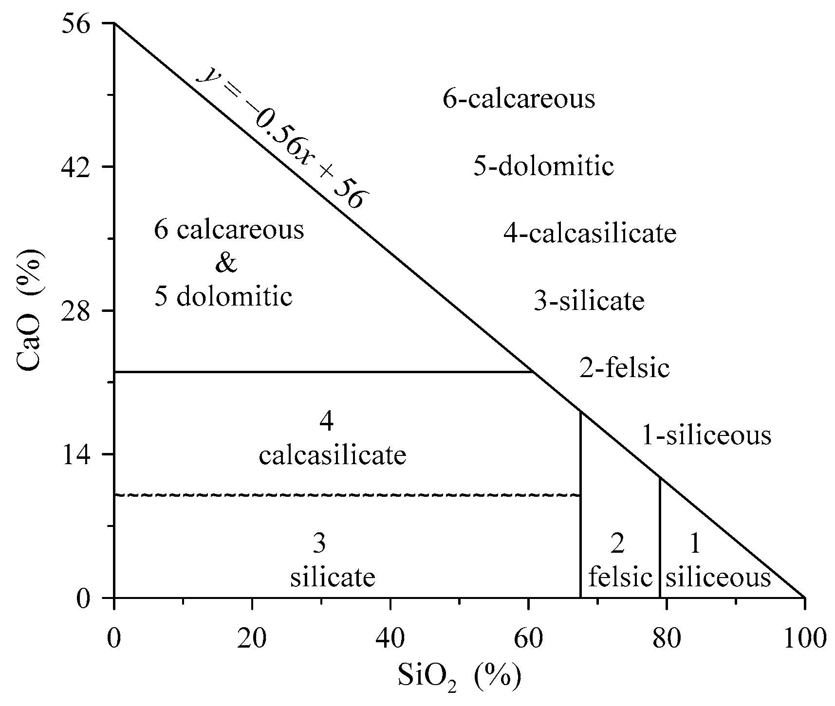
Figure 1. Diagram of geochemical classification of shale. The dividing lines of SiO2 contents correspond to 79 and 67.5, and lines of CaO correspond to 22 and 10. Here, CaO = 10 is used to approximately represent the condition of WIG = 120, and its line is drawn in a wavy style.
Applsci 15 04272 g001
Figure 2. Content variations in major oxides of CaO (a) and SiO2 (b) with classified type numbers of the 26 types of sedimentary rocks.
Applsci 15 04272 g002
Figure 3. Line graphs of SiO2 (a), CaO (b), CaO/MgO (c), WIG (d), and classified type numbers (e) of shale samples from the Zi208 well.
Applsci 15 04272 g003
Figure 4. Regional geological map of southern Sichuan area (Modified after the 1:1,000,000 geological map of H48 from China Geological Survey by the software of MapGis 6.7). (1) Quaternary: gravel, grit, sand and clay; (2) Cretaceous: lithic sandstone, fine-silt sandstone, mudstone; (3) Upper Jurassic: conglomerate, sandstone, siltstone, mudstone; (4) Middle Jurassic: mudstone, siltstone, sandstone intercalated with limestone; (5) Lower Jurassic: mudstone, sandstone, siltstone intercalated with limestone, marl; (6) Upper Triassic: feldspar quartz sandstone intercalated with siltstone; (7) Lower-Middle Triassic: lower conglomerate, sandstone, shale, purple mudstone, limestone, upper dolomite, limestone; (8) Permian: lower sand shale, limestone, dolomite, middle basalt, upper sandstone, sand shale, mudstone, coal; (9) Cambrian: shale, siltstone, sandstone, limestone, dolomite, bottom phosphorus; (10) Granite; (11) Faults; (12) Location of the Zi208 drill well.
Applsci 15 04272 g004
Figure 5. Geochemical map of the classified results on compositional data of stream sediments and soils in the southern Sichuan area.
Applsci 15 04272 g005
Table 1. The conditions on the geochemical classification of shale.
StepsConditionsType NumberComponents
1SiO2 ≥ 791Siliceous
267.5 ≤ SiO2 < 792Felsic
3WIG < 120 (with SiO2 < 67.59)3Silicate
4CaO < 22 (with WIG ≥ 120 and SiO2 < 67.59)4Calcasilicate
5CaO/MgO < 4.2 (with CaO ≥ 22)5Dolomitic
6CaO/MgO ≥ 4.2 (with CaO ≥ 22)6Calcareous
Note: The unit of SiO2, CaO, and MgO is %, and the WIG is calculated using molecular proportions of major oxides.
Table 2. Contents of major oxides, values of CaO/MgO and WIG, and classified shale types of 26 types of sedimentary rocks.
IDRocksSiO2Al2O3TFe2O3CaOMgOK2ONa2OTiO2P2O5CaO/MgOWIGClassified Types
1Mudstone (shale) (average)60.6316.355.912.661.863.450.800.760.121.4345.463
2Common mudstone (shale)61.9816.246.171.811.963.610.880.770.130.9239.423
3Silty mudstone (shale)65.5714.245.442.011.733.270.960.710.121.1645.633
4Calcareous mudstone (shale)53.6012.774.798.882.723.720.640.660.133.26125.484
5Aluminiferous mudstone (shale)54.8224.906.060.890.792.760.350.940.101.1316.503
6Sandstone (average)72.6310.913.672.521.262.401.410.490.092.0066.842
7Quartz sandstone92.763.360.970.210.210.830.110.140.031.0033.141
8Feldspar quartz sandstone81.408.262.730.850.641.920.600.400.071.3342.381
9Greywacke67.7212.514.233.351.572.691.830.540.112.1373.872
10Arkoses68.5312.654.002.781.552.702.440.520.111.7973.862
11Silty sandstone69.0813.004.761.931.512.741.320.620.101.2849.932
12Blasto-sandstone70.0012.854.421.721.892.932.200.550.130.9158.722
13Calcareous sandstone60.729.442.9410.101.792.241.250.430.105.64190.624
14Tuffaceous sandstone68.1814.503.931.881.423.242.870.500.111.3264.502
15Carbonate rock
(without argillaceous content)
6.491.140.7142.846.530.340.100.050.046.564714.756
16Carbonate rock
(with argillaceous content)
10.071.770.9840.426.250.540.140.080.056.472964.036
17Limestone3.180.660.4350.202.330.190.070.030.0221.559398.586
18Argillaceous limestone11.392.241.1943.002.940.610.180.110.0614.632515.626
19Dolomite4.450.670.6631.7017.350.240.070.040.021.835100.955
20Argillaceous dolomite12.251.350.8628.6015.550.490.130.070.051.842655.515
21Marl25.144.812.2233.651.881.190.390.240.0917.90962.816
22Dololutite27.003.902.0022.1011.801.840.070.250.071.87767.375
23Siliceous rock(average)87.344.111.610.890.680.980.250.190.061.3154.631
24Common Siliceous rock88.744.521.880.290.560.830.280.200.070.5228.601
25Carbonaceous siliceous rock82.844.881.480.890.881.820.180.260.051.0161.121
26Chert89.320.510.263.930.880.050.220.010.084.471062.521
Note: Data of sedimentary rocks in China are after [26]; the unit of major oxides is wt%; values of WIG are calculated using molecular proportions of major oxides.
Table 3. Statistical parameters of shale samples from the Zi208 well in the southern Sichuan area.
ParametersSiO2Al2O3TFe2O3CaOMgOK2ONa2OTiO2P2O5CaO/MgOWIG
Minimum value9.382.440.660.250.680.490.310.080.050.1019.80
Lower quartile value53.5213.113.583.802.332.590.560.540.081.3959.56
Median value56.9114.005.376.143.023.530.660.680.101.9183.82
Upper quartile value60.2515.385.739.853.373.700.810.720.143.25129.65
Maximum value82.5726.8642.7247.158.117.433.042.400.3568.752587.22
Mean value54.3612.915.1510.112.853.110.870.660.136.08257.12
Standard deviation value15.124.513.6411.181.101.200.610.350.0713.16496.38
Note: The unit of major oxides is %.
Table 4. Statistical parameters of stream sediment and soil samples in the southern Sichuan area.
ParametersSiO2Al2O3TFe2O3CaOMgOK2ONa2OTiO2P2O5CaO/MgOWIG
Minimum value26.121.200.390.010.040.210.050.060.010.022.87
Lower quartile value61.5710.403.550.560.941.730.630.570.160.4931.15
Median value65.8712.824.591.021.512.211.000.670.220.7440.62
Upper quartile value71.7314.135.411.982.042.601.450.750.291.2452.09
Maximum value94.7022.0318.5323.9712.956.3048.004.592.1420.44905.43
Mean value67.1312.024.511.641.542.171.100.700.230.9743.98
Standard deviation value8.342.881.661.750.820.600.820.340.110.7926.34
Note: The unit of major oxide is %.
Disclaimer/Publisher’s Note: The statements, opinions and data contained in all publications are solely those of the individual author(s) and contributor(s) and not of MDPI and/or the editor(s). MDPI and/or the editor(s) disclaim responsibility for any injury to people or property resulting from any ideas, methods, instructions or products referred to in the content.

