A Review on the Progress of Integrated Geophysical Exploration Techniques for Leakage Hazard Detection in Earth and Rock Dams
Abstract
1. Introduction
2. Current Status of Development of Geophysical Exploration Techniques
2.1. Exploration Techniques Based on Apparent Resistivity Parameters
2.1.1. Self-Potential Method
2.1.2. Electrical Resistivity Tomography Method
2.1.3. Diffusion Method Logging Exploration
2.1.4. Resistivity Computed Tomography Method
2.2. Exploration Techniques Based on Elastic Wave Velocity
2.2.1. Surface Wave Method
2.2.2. Seismic Refraction Method
2.2.3. Land Sonar Method
2.2.4. Elastic Wave Computerized Tomography Method
2.3. Exploration Techniques Based on Dielectric Constant
2.3.1. Transient Electromagnetic Method
2.3.2. Ground-Penetrating Radar Method
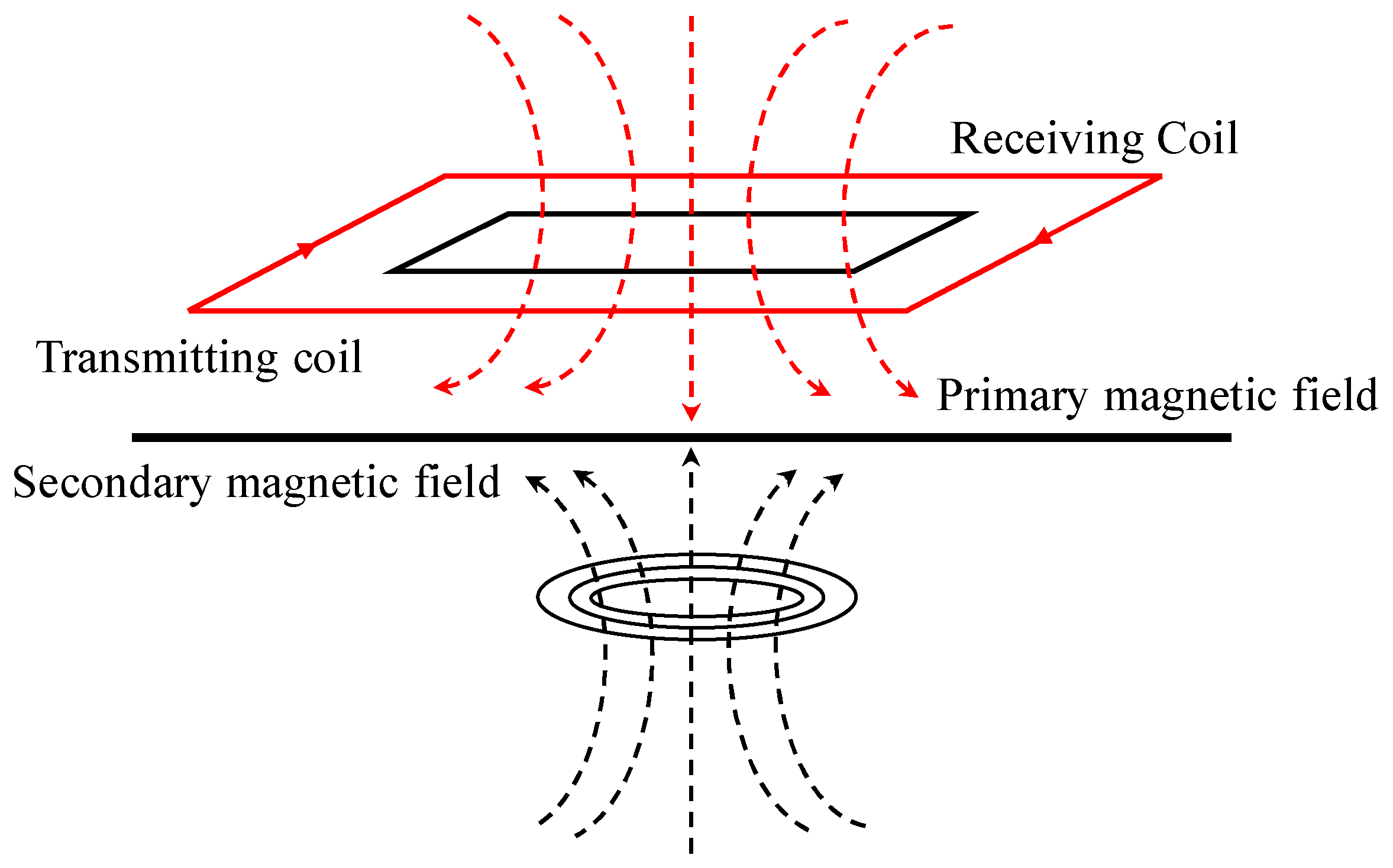
2.3.3. Magnetic Resonance Method
2.3.4. Electromagnetic Wave CT Method
2.4. Other Types of Exploration Techniques
- Water flow is the physical entity and carrier of seepage. The pseudo-random flow field method uses the current field to fit the seepage field and quickly find the entrance of seepage in earth and rock dams with respect to the seepage field distribution.
- The temperature field inside the earth and rock-fill dam is mainly dominated by heat conduction. In the case of leaking dikes, the heat transfer intensity within the dike varies with the water flow. Therefore, the change in the temperature field can be used to inverse analyze the potential leakage situation inside earth and rock dams.
- Chemical elements are used in the isotope tracer method, which uses radioactive isotopes or enriched rare stable nuclides as tracers to determine the entrance and exit of the leakage path of the dike by adding tracers upstream of the dike and conducting isotope measurements downstream.
- The process of seepage is often accompanied by water flow, water–soil friction, and soil infiltration damage. These factors produce acoustic emission phenomena, and acoustic emission monitoring is used to determine the occurrence and location of leakage.
2.4.1. Pseudo-Random Flow Field Method
2.4.2. Temperature-Field Inverse Analysis Method
2.4.3. Isotope Tracer Method
2.4.4. Infrared Thermography
2.4.5. Sonar Method
2.5. Conditions and Limitations of the Applicability of Geophysical Exploration Techniques
3. Integrated Geophysical Exploration Techniques for Earth and Rock Dams
3.1. Principles of Integrated Geophysical Exploration Techniques System
- (1)
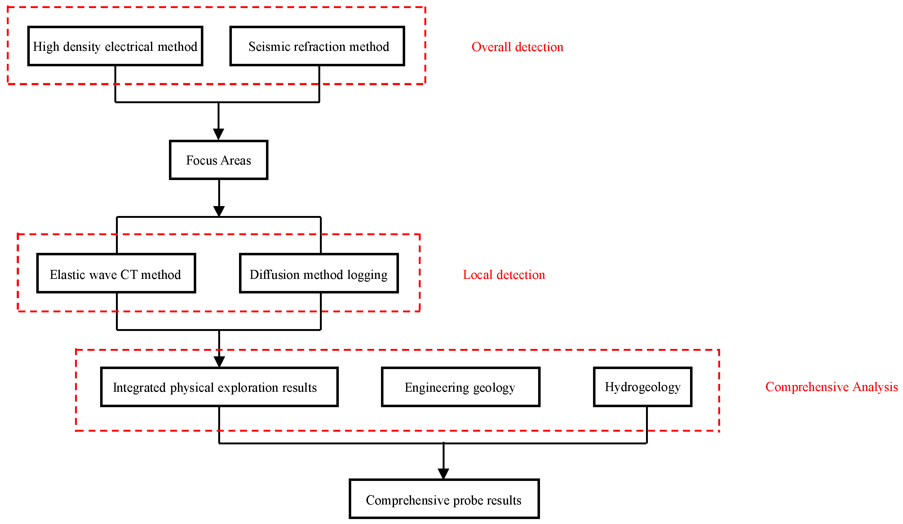
- Start with an overall probe. Geophysical exploration techniques with a lower resolution and higher efficiency can be used for the overall detection of possible leakage paths in earth and rock dams.
- (2)
- This is followed by localized precision detection. Geophysical exploration technology with a higher accuracy and resolution can be used for the fine detection of key areas where the leakage path may exist, for a more accurate identification and positioning of the leakage path in earth and rock dams.
- (3)
- The use of a single geophysical survey technique can only obtain a single physical parameter of earth and rock dams. When performing hidden danger detection, a combination of physical parameters should be chosen. The different methods should complement each other, should be mutually verifiable, and constrain each other to ensure the diversity of the detection parameters present detection results from multiple perspectives, and improve the detection accuracy [95].
3.2. Data Fusion Analysis System for GIS-Based Integrated Geophysical Exploration
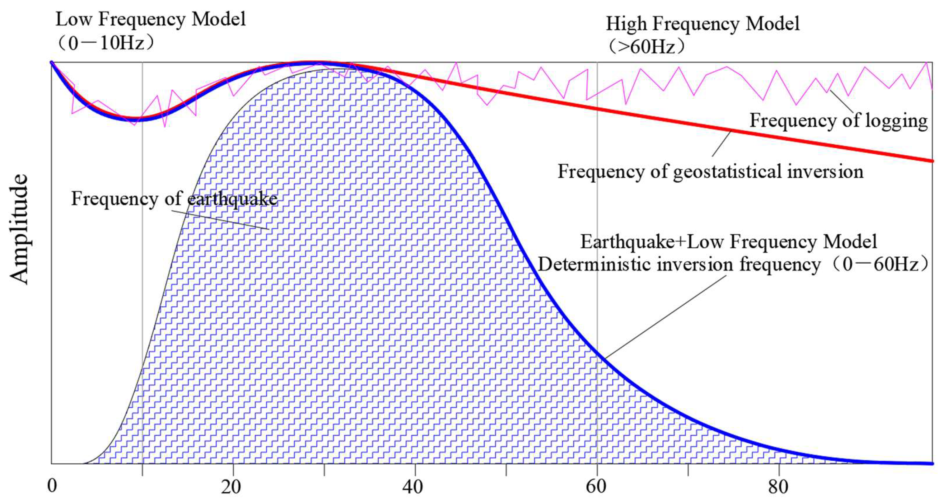
4. Integrated Geophysical Exploration Information Fusion Technology Based on Data Fusion and Joint Interpretation
- There are limitations in the application process of the technology, and the combination form is relatively single. The commonly used combinations of techniques include the electrical resistivity tomography method and sonar method, land sonar method and electric method, electromagnetic method, and pseudo-random flow field method, shallow seismic reflection method and sonar method, surface wave method and electric method, and other combinations. These are mostly based on the extension of the electrical-based geophysical exploration technology.
- The integrated geophysical exploration techniques optimizes the problem of interpreting geophysical exploration data, and to some extent reduces the multi-interpretation situation in the application of a single geophysical exploration method. However, there is no real integration of geophysical exploration techniques. The current integrated geophysical exploration techniques applied to the detection of leakage potentials in earth and rock dams are mainly at the level of combining different methods, which is in essence an optimization of experience. The data source of integrated geophysical exploration techniques is still a single physical field, which cannot meet the requirements of data information richness, accuracy, and reliability.
- In the existing technological framework, leakage hazards in earth and rock dams are detected and dealt with late. By the time leakage hazards are detected, the leakage risk has been developing inside the dam for a long time. The detection and risk control of leakage hazards are in a reactive state. With the passage of time, the location of hidden hazards may change, and the exploration data can only reflect the state at the time of exploration. In the long run, the key to ensuring the long-term stable operation of earth and rock dams is to establish a time series of physical field data inside the dam and to develop the hidden hazard monitoring technology based on integrated geophysical exploration techniques.
4.1. Objective Basis for Data Fusion and Joint Interpretation
- (1)
- Objective links between physical parameters
- (2)
- Complementarity of physical parameters at different scales
4.2. Principles of Integrated Geophysical Exploration Information Fusion Technology
- (1)
- Scale uniformity
- (2)
- Numerical uniformity
5. Conclusions and Outlook
- (1)
- The main problem in geophysical detection technology is that the use of a single geophysical exploration method produces multiple solutions. Despite the wide variety of physical exploration techniques, each technique has its own limitations and different adaptability depending on the detection environment. For example, geophysical exploration techniques based on apparent resistivity mostly require drilling holes to embed electrodes and have boundary effects. A single technique alone cannot quickly and accurately detect leakage channels in earth and rock dams.
- (2)
- Most of the commonly used integrated geophysical exploration techniques are based on electrical detection, supplemented by seismic and pseudo-random flow field methods for integrated detection, with a high resolution and accuracy. However, each geophysical exploration method has strict application conditions. Electrical-based detection may be difficult to apply under some geological conditions involving complex dikes, and there is a need to explore a combination of methods to adapt to various detection conditions.
- (3)
- The integrated geophysical exploration techniques should complement each technology, and different detection methods must be chosen based on the specific conditions of dike hazards. By constructing a quantitative evaluation model for dike hazards, multiple geological information can be provided to alleviate the phenomenon of multiple solutions, improve the data interpretation accuracy, and better integrate the detection and analysis of hazards encountered in earth and rock dams. However, the current integrated geophysical exploration techniques still stay at the level of multi-method combination, which cannot meet the requirements of information richness and data reliability. Research on the joint inversion of multi-source physical fields and data fusion is the development trend in the future.
- (4)
- Data fusion and joint inversion presuppose the existence of certain interrelationships between different geophysical parameters and some complementarity at different scales. The connection between different physical parameters of the soil body is crucial. The theoretical model of integrated geophysical exploration information fusion technology based on data fusion and joint inversion was proposed, and its basic principle and processing flow were described. Although it is still immature, the integrated geophysical exploration information fusion technology based on joint interpretation of multi-physical fields is an important research direction in the future.
- (5)
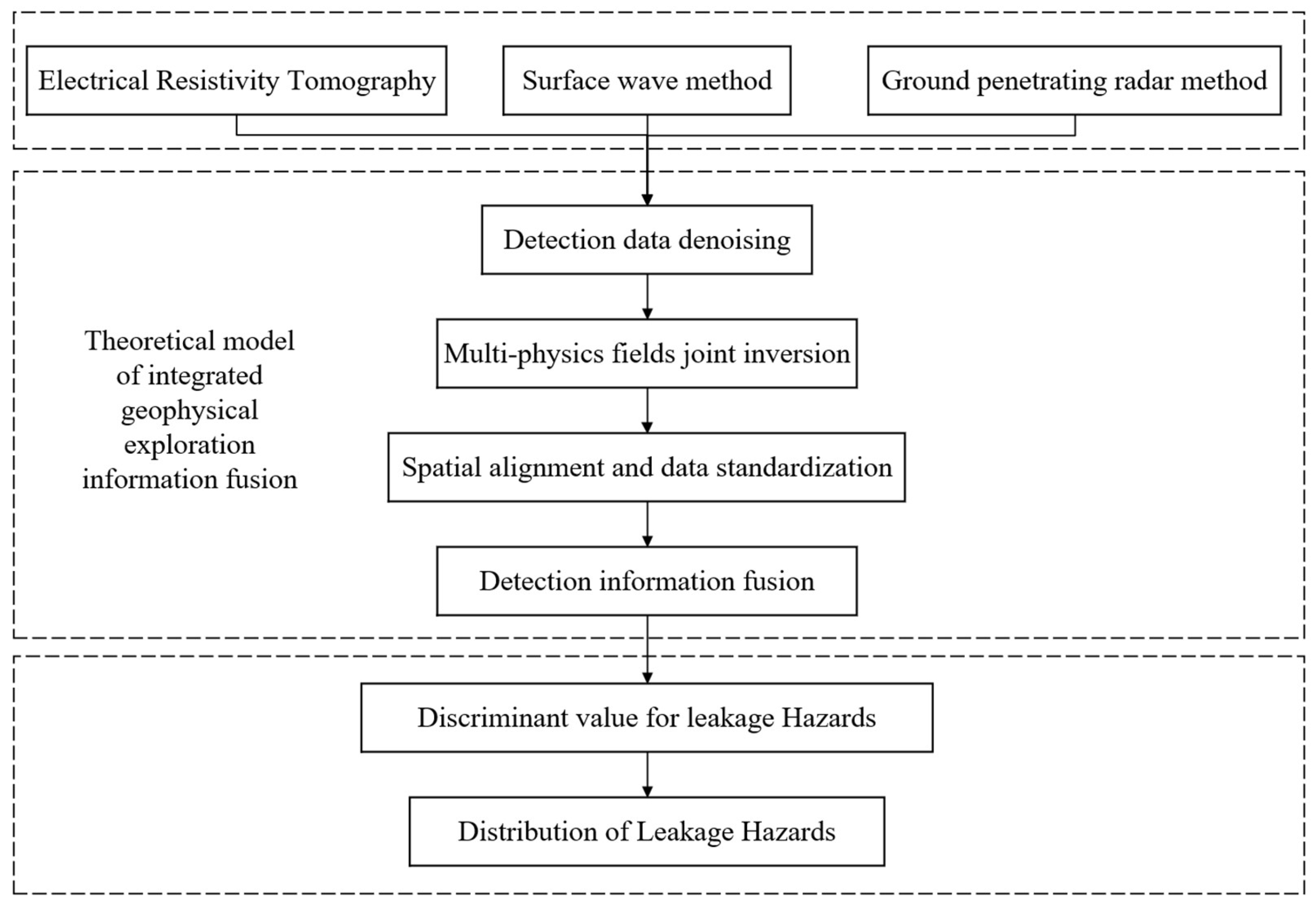
- By constructing the theoretical model for data fusion and joint inversion of multiple physical fields, different aspects of the same geophysical model can be combined to form a geologic model that is closer to the real one. The main process of the theoretical model is to derive the expression of multi-physical fields joint inversion, and then carry out spatial alignment and standardization of the data information obtained from the inversion. Finally, the information from multiple sources is integrated to accurately locate the leakage hazards based on the data fusion algorithm. This provides direction for rapid and accurate detection of leakage hazards in earth and rock dams.
- (6)
- Current geophysical exploration techniques all suffer from the limitations of time effects. The information obtained by the detection is the current situation of the exploration, and cannot reflect the dynamic changes of the hidden information. Therefore, there is a need to develop an integrated geophysical exploration information monitoring system that can monitor or predict the development of hidden hazards.
Funding
Acknowledgments
Conflicts of Interest
Appendix A. Derivation of Equations
- (1)
- Apparent resistivity conversion by surface wave method
- (2)
- Apparent resistivity conversion by ground-penetrating radar method


References
- Fan, B. Research on the Application of High-Density Electrical Method Based on Earth and Rock Embankment Leakage Potential Detection. Master’s Thesis, Zhengzhou University, Zhengzhou, China, 2020. [Google Scholar] [CrossRef]
- Fu, S.; Xiang, Y.; Wang, Z.; Zhang, K.; Huang, H. Detection of Leakage in Earth-rock Dam using High Density Resistivity Method. Res. J. Chem. Environ. 2013, 17, 215–222. [Google Scholar]
- Al-fares, W. Contribution of the geophysical methods in characterizing the water leakage in Afamia B dam, Syria. J. Appl. Geophys. 2011, 75, 464–471. [Google Scholar] [CrossRef]
- Tan, C.; Pan, Z.; Yuan, M.; Shi, Y.; Liu, J.; Lin, Y. Application of comprehensive geophysical prospecting technology in emergency detection of dike leakage. J. Water Resour. Water Eng. 2019, 30, 184–188. [Google Scholar] [CrossRef]
- Karastathis, V.K.; Karmis, P.N.; Drakatos, G.; Stavrakakis, G. Geophysical methods contributing to the testing of concrete dams. application at the Marathon Dam. J. Appl. Geophys. 2002, 50, 247–260. [Google Scholar] [CrossRef]
- Adinehvand, R.; Raeisi, E.; Hartmann, A. An integrated hydrogeological approach to evaluate the leakage potential from a complex and fractured karst aquifer, example of Abolabbas Dam (Iran). Environ. Earth Sci. 2020, 79, 501. [Google Scholar] [CrossRef]
- Chen, S.; Gu, C.; Lin, C.; Wang, Y.; Hariri-Ardebili, M.A. Prediction, Monitoring, and Interpretation of Dam Leakage Flow via Adaptative Kernel Extreme Learning Machine. Measurement 2020, 166, 108–161. [Google Scholar] [CrossRef]
- Song, S.; Song, Y.; Kwon, B.D. Application of hydrogeological and geophysical methods to delineate leakage pathways in an earth fill dam. Explor. Geophys. 2005, 36, 73–77. [Google Scholar] [CrossRef]
- Dai, Q.; Feng, D.; Wang, X. The method to detect the leakage entrance of concrete dam at Gongzui hydropower station. J. Hydroelectr. Eng. 2006, 25, 83. [Google Scholar]
- Lee, B.; Oh, S. Modified Electrical Resistivity Survey and its Interpretation for Leakage Path Detection of Water Facilities. Geophys. Geophys. Explor. 2016, 19, 200–211. [Google Scholar] [CrossRef][Green Version]
- Li, G.; Wang, J.; Liu, K. Application of Leakage Detection Technologies for a Concrete Dam. J. Yangtze River Sci. Res. Inst. 2020, 37, 169–174. [Google Scholar] [CrossRef]
- Zhao, M.; Dong, Y.; Zhao, H. Experimental study on velocity and resistivity combined tomography for diagnosing leakage in earth rock-fill dam. J. Hydraul. Eng. 2012, 43, 118–126. [Google Scholar] [CrossRef]
- Rein, A.; Hoffmann, R.; Dietrich, P. Influence of natural time-dependent variations of electrical conductivity on DC resistivity measurements. J. Hydrol. 2004, 285, 215–232. [Google Scholar] [CrossRef]
- Zhou, H.; Xiao, G.; Zhou, L.; Zhang, M.; Fu, D. Comprehensive Geophysical Detection Technologies for Hidden Dangers of Embankment and Application. J. Yangtze River Sci. Res. Inst. 2019, 36, 135–140. (In Chinese) [Google Scholar] [CrossRef]
- Hu, X.; Zhang, P.; Jiang, X. Application of parallel electric survey to quick detection of seepage passage through reservoir dam. Water Resour. Hydropower Eng. 2012, 43, 51–54. [Google Scholar] [CrossRef]
- Ogilvy, A.; Ayed, M.; Bogoslovsky, V. Geophysical studies of water leakages from reservoirs. Geophys. Prospect. 2010, 17, 36–62. [Google Scholar] [CrossRef]
- Rozycki, A.; Fonticiella, J.; Cuadra, A. Detection and evaluation of horizontal fractures in earth dams using the self-potential method. Eng. Geol. 2006, 82, 145–153. [Google Scholar] [CrossRef]
- Li, G.; Yang, T. Application of natural electric field frequency selection method in water search in chert area. West-China Explor. Eng. 2007, 19, 123–125. (In Chinese) [Google Scholar] [CrossRef]
- Li, H.; Yang, T.; Wang, Q. Application Natural Electric Field Frequency-selection Method in Groundwater Exploration Engineering. West-China Explor. Eng. 2009, 21, 114–116. (In Chinese) [Google Scholar] [CrossRef]
- Si, Z. Application of natural electric field method in probing the leakage of a reservoir dam foundation. Hydropower Water Resour. 2019, 3, 16–17. (In Chinese) [Google Scholar] [CrossRef]
- Cho, I.; Ha, I.; Kim, K.; Ahn, H.; Lee, S.; Kang, H. 3D effects on 2D resistivity monitoring in earth-fill dams. Near Surf. Geophys. 2014, 12, 73–81. [Google Scholar] [CrossRef]
- Ge, S.; Jiang, Y.; Yan, X. Application of comprehensive geophysical exploration technique to hidden trouble detection of dyke. Prog. Geophys. 2006, 21, 263–272. [Google Scholar] [CrossRef]
- Wang, G.; Wang, Q.; Guo, G.; Yuan, W.; Huang, P. Comparative study on different devices of high-density electric method in exploration. Coal Technol. 2020, 39, 68–70. [Google Scholar] [CrossRef]
- Song, C.; Wang, R.; Li, C.; Zhang, Q.; Li, Y.; Kang, Y. Research on Resistivity Tomography to Detection for Hidden Dangers of Embankment. Yellow River 2020, 42, 104–106,141. [Google Scholar] [CrossRef]
- Duan, Y.; Cheng, J.; Yang, H.; Chen, J. Analysis of the Logging Projects Optimization under Gas Medium. Well Logging Technol. 2011, 35, 183–186. [Google Scholar] [CrossRef]
- Zhao, P.; Zhang, M.; Liu, J.; Zhang, J.; Qian, L.; Yu, H. Status and Trends of Logging Techniques at Home and Abroad. Well Logging Technol. 2006, 30, 385–389. (In Chinese) [Google Scholar] [CrossRef]
- Wang, H.; Ma, L. Method for determination of measurement time of resistivity logging in artificial well liquid. Coal Geol. Explor. 2019, 47, 189–194. [Google Scholar] [CrossRef]
- Wang, H.; Ji, H. Study on CT prospecting technology by the pole-pole cross-hole direct-current resistivity method. Prog. Geophys. 2010, 25, 1833–1840. (In Chinese) [Google Scholar] [CrossRef]
- Hu, Z.; Wang, Y.; Ye, M.; Liu, M.; Ding, J. Localization of Potential Leakage Areas inside Plain Reservoirs Using Waterborne Electrical Resistivity Tomography. J. Environ. Eng. Geophys. 2021, 26, 133–143. [Google Scholar] [CrossRef]
- Liu, B.; Li, S.; Li, S.; Nie, L.; Zhong, S.; Li, L.; Song, J.; Liu, Z. Inequality constraint-based least-squares 3D resistivity inversion and its algorithm optimization. Chin. J. Geophys. 2012, 55, 260–268. [Google Scholar] [CrossRef]
- Hu, F.; Ou, Y.; Fu, M. Study on numerical simulation of karst cross-hole resistivity CT exploration at cave with different filling media. Carsologica Sin. 2019, 38, 766–773. [Google Scholar] [CrossRef]
- Cho, I.; Yeom, J. Crossline resistivity tomography for the delineation of anomalous seepage pathways in an embankment dam. Geophysics 2007, 72, G31–G38. [Google Scholar] [CrossRef]
- Tomassi, A.; Milli, S.; Tentori, D. Synthetic seismic forward modeling of a high-frequency depositional sequence: The example of the Tiber depositional sequence (Central Italy). Mar. Pet. Geol. 2024, 160, 106624. [Google Scholar] [CrossRef]
- Fu, C. Surface waves and guided waves in Earth Medium. Acta Acustica. 1965, 2, 49–55. (In Chinese) [Google Scholar]
- Xi, C.; Hu, Z.; Zhang, P. Analysis of spectral characteristics and exploration depth of vibroseis-random source. Prog. Geophys. 2018, 33, 1734–1739. (In Chinese) [Google Scholar] [CrossRef]
- Guan, X.; Lu, C.; Yin, C.; Teng, Z. Application of comprehensive surface wave method to analysis of underground voids distribution in water conservancy project. Water Sci. Eng. Technol. 2020, 44, 65–69. [Google Scholar] [CrossRef]
- Nakanishi, I.; Yamaguchi, K. A numerical experiment on nonlinear image reconstruction from first-arrival times for two-dimensional island arc structure. Earth Planets Space 2009, 34, 195–201. [Google Scholar] [CrossRef]
- Liu, J.; Wang, Y.; Liu, Z.; Pan, X.; Zong, Y. Progress and application of near-surface reflection and refraction methods. Chin. J. Geophys. 2015, 58, 3286–3305. (In Chinese) [Google Scholar]
- Wang, F.; Xiao, G.; Wu, X.; Zhou, L. Principle and Application of Land Sonar Method for Detection of Underground Karst. J. Yangtze River Sci. Res. Inst. 2005, 22, 54–56. [Google Scholar] [CrossRef]
- Qiu, D.; Zhong, S.; Li, S.; Zhang, L.; Su, M.; Sun, H. Application of the land sonar method in tunnel defective geological advanced prediction. J. Shandong Univ. 2009, 39, 17–20,29. [Google Scholar] [CrossRef]
- Wang, R.; Zhong, S.; Wang, R. The application of land sonar method in reservoir area exploration. In Proceedings of the 2015 Joint Academic Conference on Earth Sciences in China, Beijing, China, 11–14 August 2015; pp. 1502–1504. (In Chinese). [Google Scholar]
- Xue, L.; Liu, T. FEM Inversion Algorithm in Frequency Domain for Elastic Wave CT Based on Energy Minimization Principles. China Earthq. Eng. J. 2018, 40, 376–383. [Google Scholar] [CrossRef]
- Pan, J.; Song, C.; Leng, Y.; Li, Y.; Wang, X.; Zhao, X.; Gao, D.; Li, D. The Application of Seismic Wave CT to Qualities Detection of Concrete Cut-off Walls. Comput. Tomogr. Theory Appl. 2016, 25, 311–317. [Google Scholar] [CrossRef]
- Tu, S.; Wu, G.; Pei, S. Application of Elastic Wave CT to Detection of Dam Cutoff Wall. Chin. J. Eng. Geophys. 2010, 7, 286–291. (In Chinese) [Google Scholar] [CrossRef]
- Choi, P.; Kim, D.; Lee, B.; Won, M.C. Application of ultrasonic shear-wave tomography to identify horizontal crack or delamination in concrete pavement and bridge. Constr. Build. Mater. 2016, 121, 81–91. [Google Scholar] [CrossRef]
- Zhao, B. Comprehensive geophysical exploration method to detect the size of cracks and grouting effect of the dam. Pearl River Water Transp. 2016, 24, 88–89. [Google Scholar] [CrossRef]
- Hao, S.; Wang, Y.; Xu, J. Application of elastic wave laminar scanning (CT) method in nondestructive testing of PC continuous beams. Highway 2018, 63, 226–230. [Google Scholar]
- Gutiérreza, F.; Mozafari, M.; Carbonel, D.; Gómez, R.; Raeisi, E. Leakage problems in dams built on evaporites. The case of La Loteta Dam (NE Spain), a reservoir in a large karstic depression generated by interstratal salt dissolution. Eng. Geol. 2015, 185, 139–154. [Google Scholar] [CrossRef]
- Chi, T.; Cao, G.; Li, B.; Zikl, A.; Wang, W. Research on Real-time Detection about Soil Salinization Based on Dielectric Properties. J. Shenyang Agric. Univ. 2018, 49, 491–497. [Google Scholar] [CrossRef]
- Lin, C.; Wang, X.; Nie, L.; Sun, H.; Liu, L. Comprehensive Geophysical Investigation and Analysis of Lining Leakage for Water-Rich Rock Tunnels: A Case Study of Kaiyuan Tunnel, Jinan, China. Geotech. Geol. Eng. 2020, 38, 3449–3468. [Google Scholar] [CrossRef]
- Luo, X.; Gong, S.; Huo, Z.; Li, H.; Ding, X. Application of Comprehensive Geophysical Prospecting Method in the Exploration of Coal Mined-Out Areas. Adv. Civ. Eng. 2019, 2019, 1–17. [Google Scholar] [CrossRef]
- Zhang, T.; Lu, T.; Ma, J.; Rong, P. The Application of Transient Electromagnetic Method in Detection of Underground Metal Object. J. Proj. Rocket. Missiles Guid. 2006, 26, 293–295. (In Chinese) [Google Scholar] [CrossRef]
- Zhou, J.; Li, X.; Qi, Z. Research progress on marine transient electromagnetic method. Prog. Geophys. 2016, 31, 1406–1412. [Google Scholar] [CrossRef]
- Zhang, J. Research on the influence of the mine transient electromagnetic advanced detection tunne. Comput. Tech. Geophys. Geochem. Explor. 2017, 39, 17–22. [Google Scholar] [CrossRef]
- Zeng, X.; Xu, W.; Qian, R.; Deng, X. Groud Penetrating Radar High Resolution Exploration Reservoir Dam Strcture Layer. Prog. Geophys. 2000, 15, 104–109. (In Chinese) [Google Scholar] [CrossRef]
- Loke, M.; Chambers, J.; Rucker, D.; Kuras, O.; Wilkinson, P. Recent developments in the direct-current geoelectrical imaging method. J. Appl. Geophys. 2013, 95, 135–156. [Google Scholar] [CrossRef]
- Wang, Y.; Jin, H.; Li, G. Investigation of the free-thaw states of foundation soils in permafrost areas along the China-Russia Crude Oil Pipeline (CRCOP) route using ground-penetrating radar (GPR). Cold Reg. Sci. Technol. 2016, 126, 10–21. [Google Scholar] [CrossRef]
- Gao, S.; Xu, Y.; Zhao, G.; Wang, M. Numerical simulation of embankment seepage flow based on ground-penetrating radar hidden danger detection. Yangtze River 2017, 48, 152–155. [Google Scholar]
- Miorali, M.; Zhou, F.; Slob, E.; Arts, R. Coupling ground penetrating radar and fluid flow modeling for oilfield monitoring applications. Geophysics 2011, 76, A21–A25. [Google Scholar] [CrossRef]
- Leng, Y.; Zhu, W.; He, J.; Liu, J. The current situation and outlook of China’s dike hidden danger and leakage detection technology. Adv. Sci. Technol. Water Resour. 2002, 22, 59–62. (In Chinese) [Google Scholar] [CrossRef]
- Zeng, Z.; Tian, G.; Ding, K. The broadband GPR system study and its application in engineer inspecting. Prog. Geophys. 2003, 18, 455–459. [Google Scholar] [CrossRef]
- Zhang, D.; Li, J.; Wu, Z.; Ren, L. Application and progress of ground penetrating radar in active fault detection. J. Geomech. 2016, 22, 733–746. (In Chinese) [Google Scholar] [CrossRef]
- Li, X.; Liu, W.; Zhi, Q.; Zhao, W. Three-dimensional joint interpretation of nuclear magnetic resonance and transient electromagnetic data. Chin. J. Geophys. 2015, 58, 2730–2744. [Google Scholar] [CrossRef]
- Liu, J.; Tian, B.; Ji, Y.; Jiang, C. Dual-frequency magnetic resonance sounding method for groundwater detection under unknown Larmor frequency. Chin. J. Geophys. 2020, 63, 4244–4255. [Google Scholar] [CrossRef]
- Lin, J.; Zhu, J.; Wang, H.; Teng, F.; Zhang, Y. A review on the progress of the underground nuclear magnetic resonance method for groundwater disaster forecasting detection of tunnels and mines. J. Appl. Geophys. 2020, 177, 104041. [Google Scholar] [CrossRef]
- Wang, W.; Deng, X.; Jin, C.; Zhou, H.; Lin, S. The Characteristics of Karst Development in Major Projects Revealed by Electromagnetic Wave Computed Tomography: A Case for Karst Investigation of a Metro. Sci. Technol. Eng. 2020, 20, 13977–13982. [Google Scholar] [CrossRef]
- Li, C.; Wang, L.; Zhong, K. Application of Electromagnetic Wave Computerized Tomography to Testing Quality of Pile. Geol. J. China Univ. 2003, 9, 467–473. [Google Scholar] [CrossRef]
- Lei, X.; Li, Z. Image characters and calculation formula of diameter of underground grotto by cross-well electromagnetic wave CT technique. Comput. Tech. Geophys. Geochem. Explor. 2006, 28, 142–145. [Google Scholar] [CrossRef]
- Zhang, C.; Liu, W.; Chu, J.; Hu, H. Application of Electromagnetic Wave CT Technology in Engineering Geological Survey. Geomat. Sci. Technol. 2020, 8, 47–53. (In Chinese) [Google Scholar] [CrossRef]
- Tang, J.; Dai, Q.; Liu, J.; Zhu, Z.; Li, D. Academic achievements of Professor HE Ji-shan dedicated to geophysics for six decades. Chin. J. Nonferrous Met. 2013, 23, 2323–2339. [Google Scholar] [CrossRef]
- Dong, Y.; Xu, F.; Wan, H. The Application of Detecting the Hidden Defect in Dams with Pseudorandom Flowing field Method. Equip. Geotech. Eng. 2006, 7, 19–21. [Google Scholar] [CrossRef]
- He, J. Combined Application of Wide-Field Electromagnetic Method and Flow Field Fitting Method for High-Resolution Exploration: A Case Study of the Anjialing No. 1 Coal Mine. Engineering 2018, 4, 188–205. [Google Scholar] [CrossRef]
- Zhu, C.; Wang, Y.; Yan, B.; Gao, H. Numerical Simulation on Real-Time Temperature Field and Strength Field of Bridge Mass Concrete. Archit. Build. Mater. 2011, 99–100, 346–349. [Google Scholar] [CrossRef]
- Wang, X.; Zeng, C.; Xu, B.; Chen, J. Model for detecting multiple concentrated seepage passages in earth dams based on reverse analysis of temperature field. J. Hydraul. Eng. 2009, 40, 486–491. [Google Scholar] [CrossRef]
- Liu, Y.; Nie, Y. Field back analysis of temperature problems and construction feedback. J. Hohai Univ. 2003, 31, 530–533. (In Chinese) [Google Scholar] [CrossRef]
- Chang, P.; Chen, J.; Wang, S.; Huang, D.; Zeng, M. Detection of the Dam Leakage Passage Position Based on Reverse Analysis Method of Temperature Field. Yellow River 2014, 36, 131–134. [Google Scholar] [CrossRef]
- Bai, X.; Lv, M.; Wang, H. The Pioneer of Isotope Tracer Method-George de Hevesy. Chemistry 2017, 80, 593–599. [Google Scholar]
- Liu, J.; Chen, J. Two typical examples of bedrock seepage cause of diseased dykes. Chin. J. Rock Mech. Eng. 2003, 22, 683–688. [Google Scholar]
- Chen, J.; Dong, H.; Chen, L.; Yang, S. Study on leakage of Xin’anjiang Dam by oxygen and hydrogen isotope tracer method. Nucl. Tech. 2005, 28, 239–242. [Google Scholar] [CrossRef]
- Hocini, N.; Moulla, A. Detection of Water Leaks in Foum El—Gherza Dam (Algeria). In Proceedings of the 5th International Yellow River Forum on Ensuring Water Right of the River’s Demand and Healthy River Basin Maintenance, Zhengzhou, China, 24–28 September 2012; pp. 22–27. [Google Scholar]
- Peng, T.; Wang, C. Identification of sources and causes of leakage on a zoned earth dam in northern Taiwan: Hydrological and isotopic evidence. Appl. Geochem. 2008, 23, 2438–2451. [Google Scholar] [CrossRef]
- Li, H.; Sheng, J.; He, J. Research on Methods and Influencing Factors of Obtaining Abnormal Temperature Region of Infrared Image Based on Indoor Experiment. IEEE Sens. J. 2021, 21, 11101–11108. [Google Scholar] [CrossRef]
- Chen, C.; Chen, S.; Chen, K.; Liu, Z. Thermal monitoring and analysis of the large-scale field earth-damage breach process. Environ. Monit. Assess. 2018, 190, 483. [Google Scholar] [CrossRef]
- Bukowska-Belniak, B.; Lesniak, A. Leaks detection in sequence of environmental infrared images. In Proceedings of the 13th Quantitative Infrared Thermography Conference (QIRT), Gdansk Univ Technol, Fac Elect Telecommunicat and Informat, Gdansk, Poland, 4–8 July 2016; pp. 131–134. [Google Scholar] [CrossRef]
- Inagaki, T.; Okamoto, Y. Diagnosis of the leakage point on a structure surface using infrared thermography in near ambient conditions. NDT E Int. 1997, 30, 135–142. [Google Scholar] [CrossRef]
- Peng, B.; Zhang, D. Study on Detecting Concentrated Leakage in Earth-rock Dam by Infrered Imaging Technique. Sci. Technol. Eng. 2016, 16, 93–98,103. [Google Scholar] [CrossRef]
- Lü, S.; Liu, X. Development and Research Status of Infrared Thermal Image Detection Technology. Infrared Technol. 2018, 40, 214–219. (In Chinese) [Google Scholar]
- Wang, Z. Application and effect of integrated geophysical exploration method for a bridge over Yangtze River. Pioneer. Sci. Technol. Mon. 2006, 19, 183–184. (In Chinese) [Google Scholar] [CrossRef]
- Zhang, S.; Zhang, X.; Lu, Q. Application of comprehensive geophysical exploration in detection of mined area under Zaomu highway. Chin. J. Geol. Hazard Control 2012, 23, 94–98. (In Chinese) [Google Scholar] [CrossRef]
- Li, S. Application of Geophysical Exploration Technology in Coral Reef Geotechnical Investigation for the Cross-Harbour Bridge in Maldives. In Proceedings of the China Survey and Design Association, National Survey and Design Industry to Implement the “One Belt and One Road” Strategy Seminar, Beijing, China, 27 October 2016; pp. 320–325. (In Chinese). [Google Scholar]
- Yang, L.; Li, B.; Gao, H.; Liu, A.; Liu, J. Application of Comprehensive Geophysical Exploration Technique to the Detection of Daning Storage Reservoir Seepage Prevention Wall. Sci. Technol. Eng. 2012, 12, 3657–3661. [Google Scholar] [CrossRef]
- Berhane, G.; Amare, M.; Gebreyohannes, T.; Walraevens, K. Geological and geophysical investigation of water leakage from two micro-dam reservoirs: Implications for future site selection, northern Ethiopia. J. Afr. Earth Sci. 2017, 129, 82–93. [Google Scholar] [CrossRef]
- Zhou, H.; Xiao, G.; Zhou, L.; Chen, Z.; Zhang, M. Geophysical Detection Technology of Hidden Embankment Troubles: Current Research Status and Prospect. J. Yangtze River Sci. Res. Inst. 2019, 36, 164–168. (In Chinese) [Google Scholar] [CrossRef]
- Zhang, J.; Xu, L.; Li, P.; Ma, S.; Xiao, L. Experimental study on comprehensive geophysical prospecting technology in dam leakage detection. Prog. Geophys. 2018, 33, 432–440. [Google Scholar] [CrossRef]
- Wang, P. Application of integrated geophysical exploration method in dam leakage detection. Shaanxi Water Resour. 2019, 88, 44–45+50. (In Chinese) [Google Scholar] [CrossRef]
- Ma, G.; Li, Z. The Application of Comprehensive Geophysical Prospecting Technology to Landslide Monitoring. Chin. J. Eng. Geophys. 2016, 13, 191–195. [Google Scholar] [CrossRef]
- Yang, F.; Bai, G. Example analysis of the application of geophysical exploration technology in the detection of hidden dangers in dams. Heilongjiang Sci. Technol. Water Conserv. 2011, 39, 94–98. (In Chinese) [Google Scholar] [CrossRef]
- Ju, H.; Zhao, J.; Li, J.; Xu, B.; Luo, C. Application of the Comprehensive Geophysical Prospecting Techniques in Hidden Trouble Detection of Tailings Dam. Appl. Mech. Mater. 2012, 166–169, 2562–2565. [Google Scholar] [CrossRef]
- Zhang, W.; Liao, G.; Qin, Q. Based on open-source GIS platform to build 2D visual geophysical information management software. Geophys. Geochem. Explor. 2014, 38, 1064–1069. (In Chinese) [Google Scholar] [CrossRef]
- Tan, S. The analysis and implementation of a cross-platform 3D GIS system. Comput. Eng. Softw. 2014, 35, 94–97. (In Chinese) [Google Scholar] [CrossRef]
- Suo, X.; Cai, Z.; Zhang, S. The application of analysis system to integrated geophysical techniques in geological hazard investigation. J. Hebei Agric. Univ. 2003, 26, 304–305+309. [Google Scholar] [CrossRef]
- Han, S.; Ke, D.; Hou, H.; Hu, S. Development of data processing system for regional geophysical and geochemical exploration of sandstone-hosted uranium deposits based on ArcGIS Engine. Chin. J. Nucl. Sci. Eng. 2010, 30, 372–379. [Google Scholar] [CrossRef]
- Domazetovi, F.; Siljeg, A.; Loncar, N.; Maric, I. GIS automated multicriteria analysis (GAMA) method for susceptibility modelling. MethodsX 2019, 6, 2553–2561. [Google Scholar] [CrossRef]
- Zhang, L.; Xie, Y.; Luan, X.; Zhang, X. Multi-source heterogeneous data fusion. In Proceedings of the 2018 International Conference on Artificial Intelligence and Big Data (ICAIBD), Chengdu, China, 26–28 May 2018; pp. 47–51. [Google Scholar]
- Falegnami, A.; Tomassi, A.; Gunella, C.; Amalfitano, S.; Corbelli, G.; Armonaite, K.; Fornaro, C.; Giorgi, L.; Pollini, A.; Caforio, A.; et al. Defining conceptual artefacts to manage and design simplicities in complex adaptive systems. Heliyon 2024, 10, e41033. [Google Scholar] [CrossRef]
- Shen, Z.; Zhao, J.; Wu, L. A Flexible Tolerance Method of Inverting the Percolation Parameter. Water Resour. Power 1999, 17, 5–9. [Google Scholar] [CrossRef]
- Xu, L.; Huang, B.; Lu, Y.; Jiang, Y. Study on Seepage Characteristics and Anti-seepage Measures for CFRD with Geological Defects. Water Power 2015, 41, 48–53. (In Chinese) [Google Scholar] [CrossRef]
- Wang, M. The Relationship Between Sonic Logging Velocity and Seismic Velocity. Master’s Thesis, China University of Petroleum, Beijing, China, 2017. (In Chinese). [Google Scholar]
- Yang, J.; Lin, N.; Zhang, H.; Wei, B. The impact of Dielectric on MWD Array Electromagnetic Wave Resistivity Tools and Correction Method. Pet. Drill. Tech. 2009, 37, 29–33. (In Chinese) [Google Scholar] [CrossRef]






| Physical Property | Techniques | Advantages and Application | Limitations |
|---|---|---|---|
| Apparent resistivity | High-density electrical method Self-potential method Resistivity CT method Diffusion method logging | 1. can visually reflect the changes in the different nature of the medium and the yield and depth of the abnormal parts, commonly used in the overall and local detection. 2. strong anti-interference ability, light and fast, light and small equipment, high accuracy, often used in the overall detection. 3. higher accuracy, detection effect is obvious, often used in local detection. 4. simple operation, better accuracy, commonly used in local detection. | 1. to ensure the resolution, the electrode distance should not exceed 1.0 m and the measuring line arrangement needs to be long enough. 2. electrode grounding problems, possibly disturbed by stray currents. 3. lossy detection, and the need to meet the dike leakage channel through the borehole between. 4. lossy detection, requiring multiple pairs of boreholes. |
| Elastic wave velocity | Seismic refraction Method Surface wave method Elastic wave CT method Sonar method Land sonar method | 1. relative reflection method, gun point density, the number of coverage is relatively low, low cost, the overall detection. 2. (transient) surface wave method of light and simple equipment, short operation time, high efficiency, local detection. 3. higher accuracy and local detection. 4. simple operation, non-destructive detection, auxiliary detection. 5. high resolution, simple and easy to identify images, light instrumentation, strong anti-interference capability, does not affect the normal work of the dike, overall and local detection. | 1. detection depth is shallow (generally not more than 100 m), requiring the lower layer wave velocity to be greater than the upper layer wave velocity, the existence of boundary effects. 2. shallow detection depth, not applicable to large and medium-sized dikes with deep seepage points and boundary effects. 3. lossy detection, requiring multiple pairs of boreholes deep to the bottom of the dike. 4. the distribution of seepage channels inside the dike cannot be determined. 5. the use of water conservancy is not popular. It is mainly used in railroad surveys and geotechnical surveys. |
| Dielectric constant | Ground-penetrating radar method Transient electromagnetic method Electromagnetic wave CT method Magnetic resonance method | 1. radar reflection image information-rich, overall and local detection. 2. easy handling, adaptability to the ground, high efficiency and overall detection. 3. better accuracy, better disclosure of underground hidden situation, local detection. 4. detection efficiency and resolution are high, the overall detection. | 1. serious attenuation of electromagnetic waves in areas with high water content, resulting in a short effective detection distance and poorer detection for deeper seepage points. 2. the existence of detection blind areas at shallow depths and low resolution. 3. lossy detection, requiring multiple pairs of boreholes at depths to the bottom of the dam. 4. poor anti-interference capability. |
| Other categories | Pseudo-random flow field method Temperature field inverse analysis method Isotope tracer method Infrared thermal imaging method Sonar method | 1. higher sensitivity, resolution, anti-interference ability, simple and efficient operation, auxiliary detection. 2. auxiliary detection. 3. easy to operate, non-destructive detection, auxiliary detection. 4. high mobility, efficiency and coverage. 5. high mobility, simple and convenient operation. | 1. the distribution of leakage channels cannot be determined. 2. lossy detection, requiring drilling and low accuracy. 3. the distribution of leakage channels cannot be determined. 4. surface detection techniques, which cannot detect the internal hidden features of the dike, with lower image resolution and less detail of image information. 5. unable to determine the distribution of leakage channels inside the dike. |
| Physical Parameters | Physical Parameter Relationships | Meaning of Parameters |
|---|---|---|
| Resistivity | ① | a Coefficients related to lithology b Constants related to lithology m Gluing index n Saturation Index ρw Resistivity of stratigraphic water ρt Resistivity of the strata Sw Water content saturation Φ Porosity |
| Primary wave | λ Lamé constant μ Shear modulus ρ Density υ Poisson’s ratio E Young’s modulus | |
| Secondary wave | μ Shear modulus ρ Density υ Poisson’s ratio E Young’s modulus | |
| Visual resistivity (homogeneous) | ② | Rt Depending on the resistivity V Sound wave speed H Depth k, c, d Regional constants |
| Wave impedance | ρ Density Vp Primary wave |
Disclaimer/Publisher’s Note: The statements, opinions and data contained in all publications are solely those of the individual author(s) and contributor(s) and not of MDPI and/or the editor(s). MDPI and/or the editor(s) disclaim responsibility for any injury to people or property resulting from any ideas, methods, instructions or products referred to in the content. |
© 2025 by the authors. Licensee MDPI, Basel, Switzerland. This article is an open access article distributed under the terms and conditions of the Creative Commons Attribution (CC BY) license (https://creativecommons.org/licenses/by/4.0/).
Share and Cite
Zhang, G.; Xu, L.; Qiu, F.; Shen, Z.; Zhang, Y. A Review on the Progress of Integrated Geophysical Exploration Techniques for Leakage Hazard Detection in Earth and Rock Dams. Appl. Sci. 2025, 15, 1767. https://doi.org/10.3390/app15041767
Zhang G, Xu L, Qiu F, Shen Z, Zhang Y. A Review on the Progress of Integrated Geophysical Exploration Techniques for Leakage Hazard Detection in Earth and Rock Dams. Applied Sciences. 2025; 15(4):1767. https://doi.org/10.3390/app15041767
Chicago/Turabian StyleZhang, Guochen, Liqun Xu, Fei Qiu, Zhiyuan Shen, and Yin Zhang. 2025. "A Review on the Progress of Integrated Geophysical Exploration Techniques for Leakage Hazard Detection in Earth and Rock Dams" Applied Sciences 15, no. 4: 1767. https://doi.org/10.3390/app15041767
APA StyleZhang, G., Xu, L., Qiu, F., Shen, Z., & Zhang, Y. (2025). A Review on the Progress of Integrated Geophysical Exploration Techniques for Leakage Hazard Detection in Earth and Rock Dams. Applied Sciences, 15(4), 1767. https://doi.org/10.3390/app15041767


