
Application of Acoustic Emission Technique in Landslide Monitoring and Early Warning: A Review

Abstract
1. Introduction
2. Current Landslide Monitoring Methods
2.1. Geodetic Methods
2.2. Geotechnical Methods
2.3. Geophysical Methods
2.4. Remote Sensing Methods
2.5. Limitations of Existing Methods
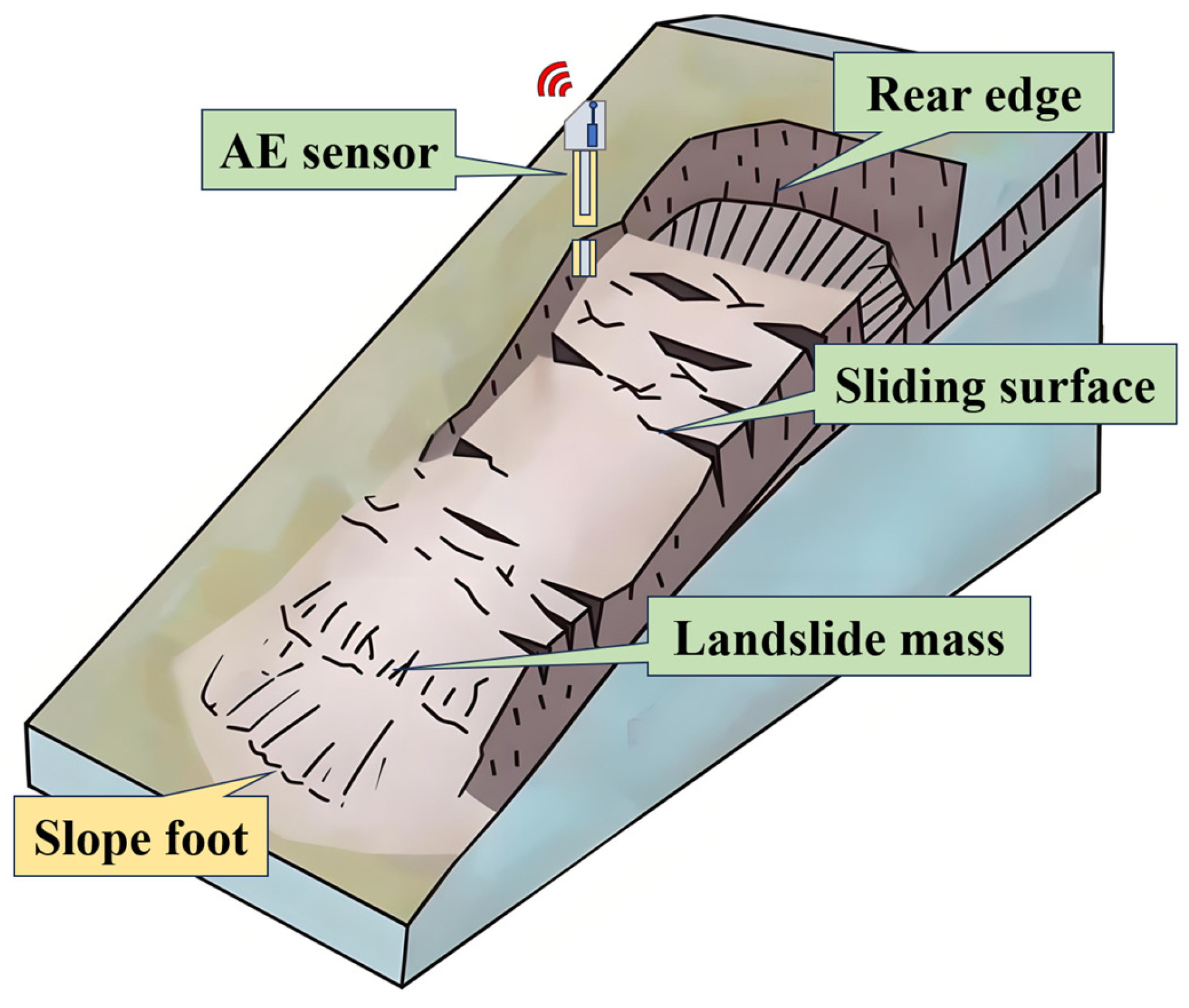
3. Fundamentals of Acoustic Emission Technique
3.1. Acoustic Emission Phenomenon
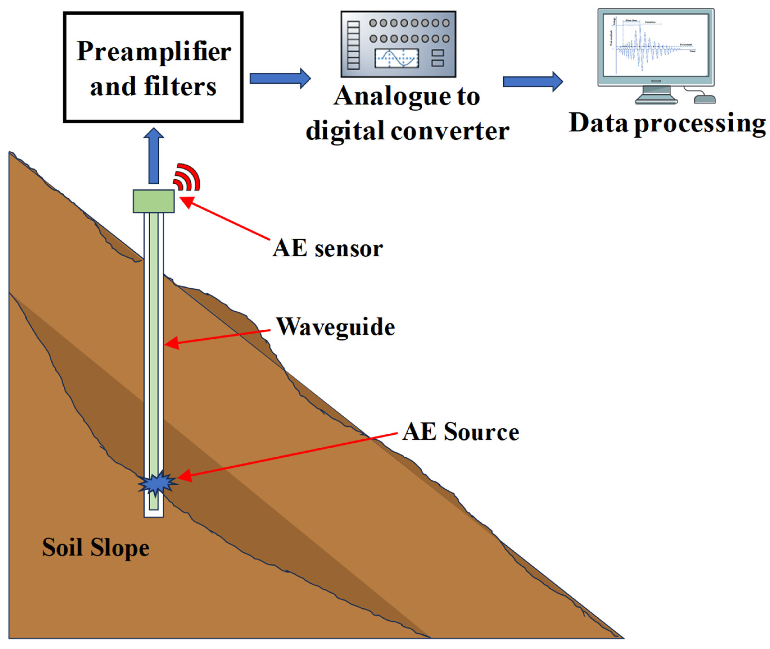
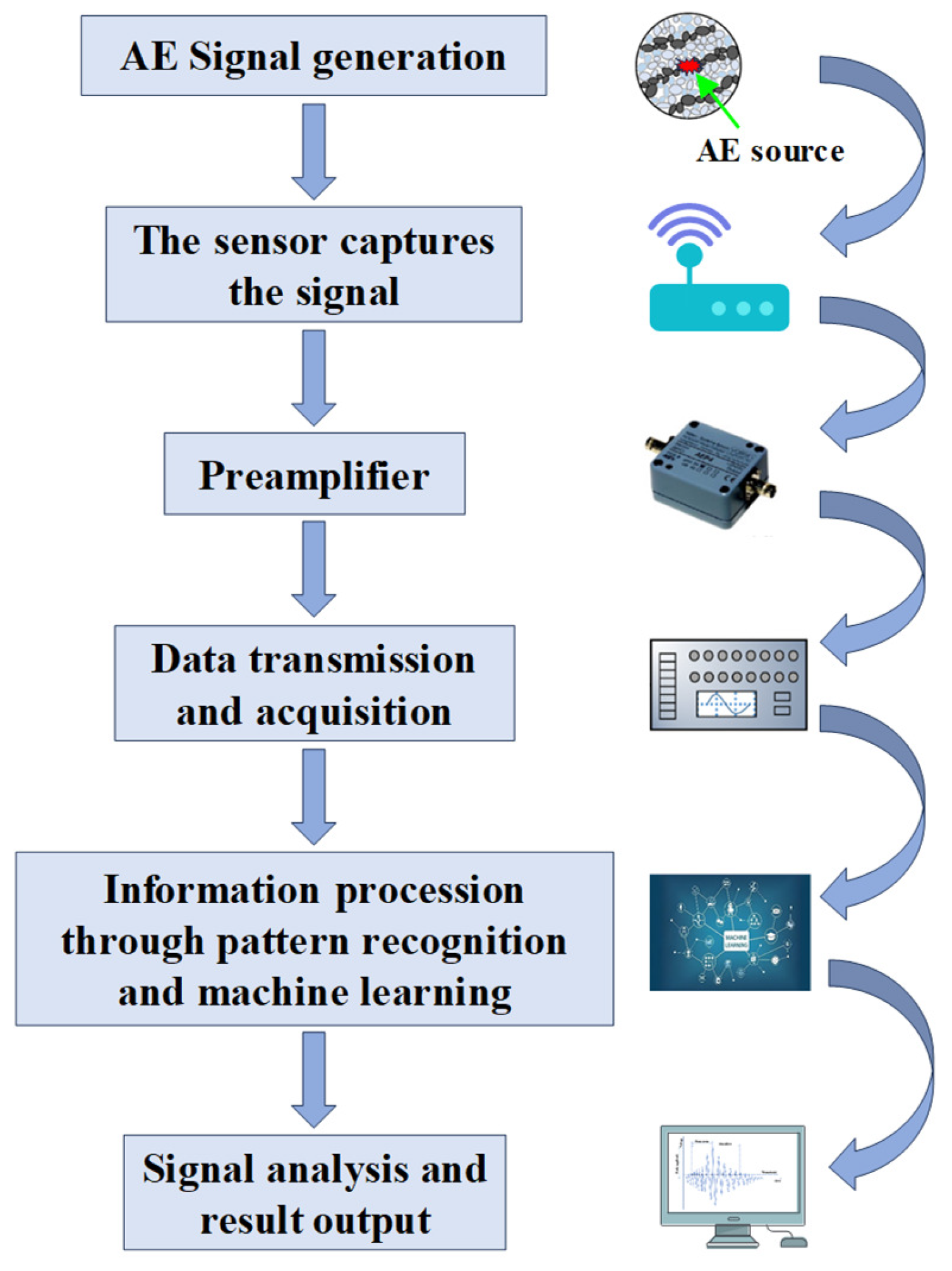
3.2. Instrumentation for Acoustic Emission Monitoring
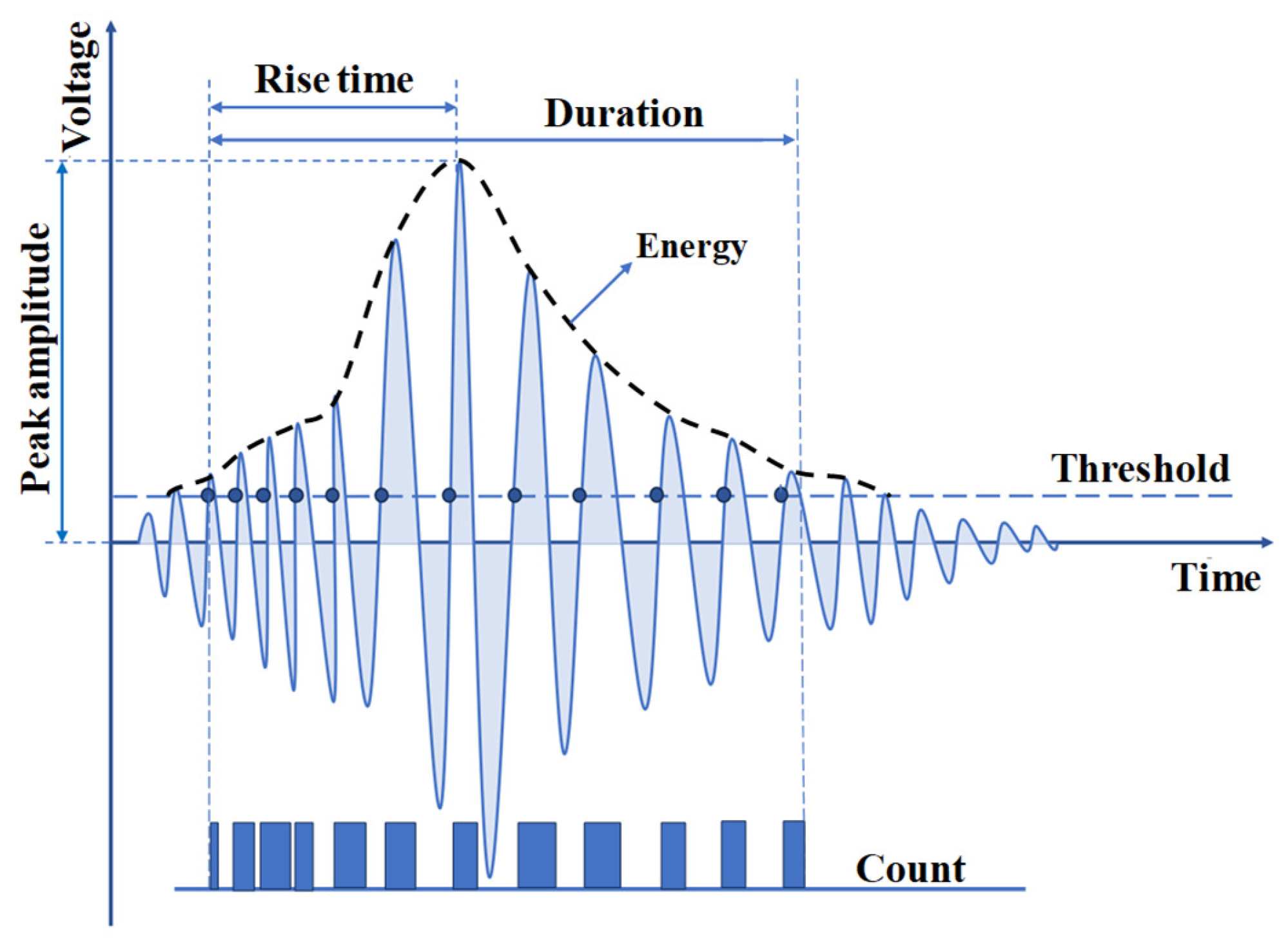
3.3. Parameters of Acoustic Emission Signals
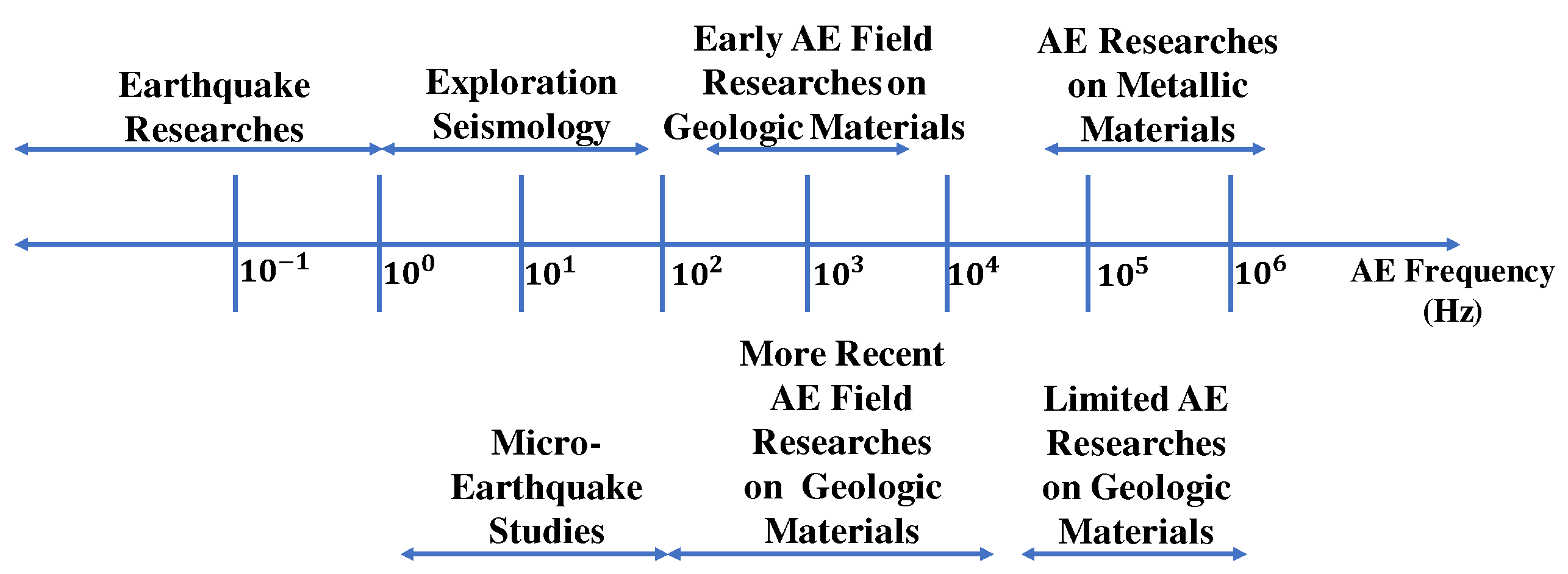
3.4. Frequency Characteristics of Acoustic Emission in Soils
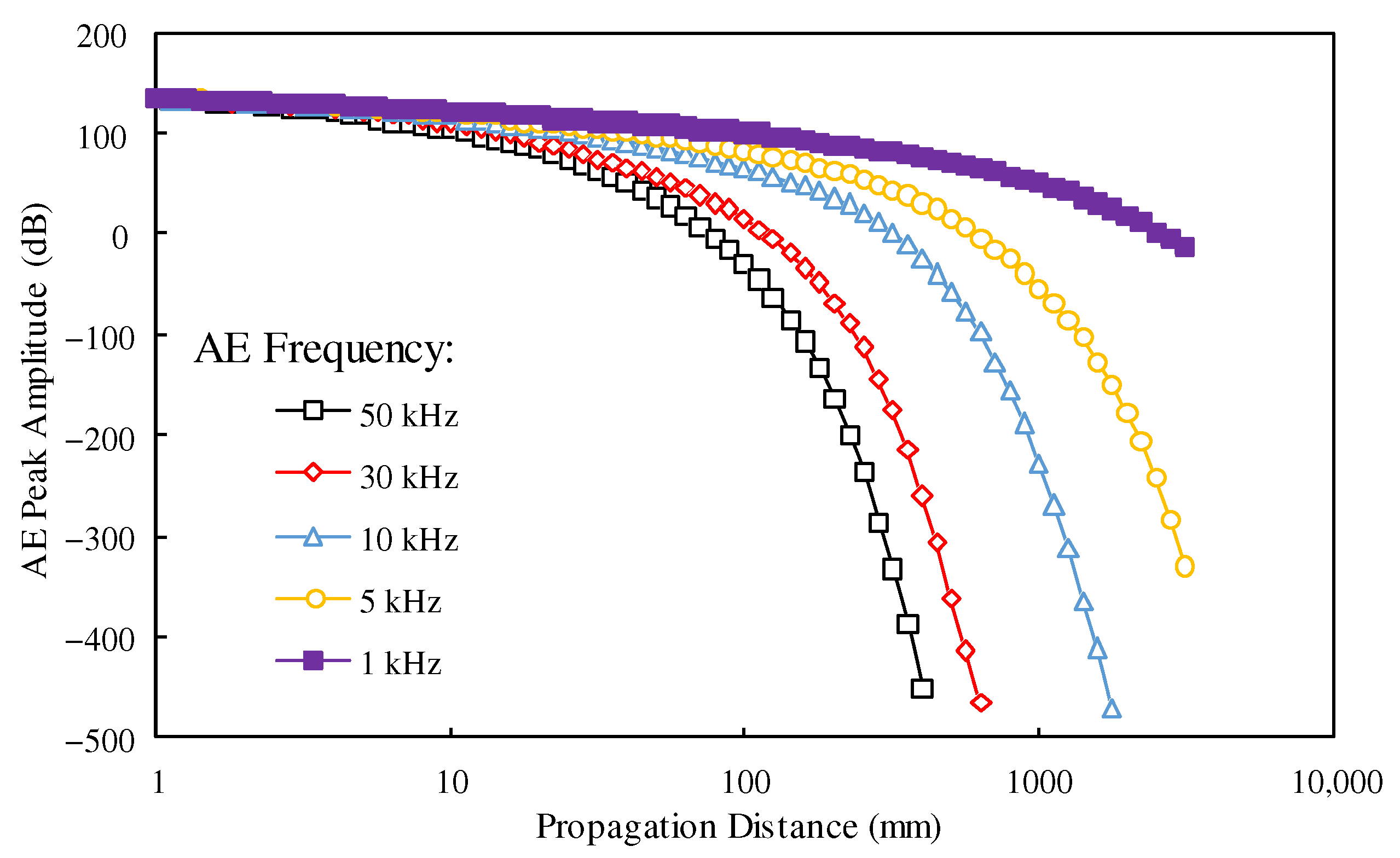
3.5. Attenuation Characteristics of Acoustic Emission in Soils
4. Discussion
4.1. Field Monitoring of Soil Slopes
4.2. Monitoring of Rock Slopes
4.3. Quantification of Acoustic Emission Signals
- Low: below 1000 AE counts with a low probability of failure [129].
- Moderate: 1000–10,000 counts indicating marginal stability requiring monitoring [118].
- High: 10,000–100,000 counts, representing an unstable state demanding remediation [119].
- Very high: above 100,000 counts, signaling failure onset necessitating evacuation [118].
- Establishing linear scaling between the natural logarithm of the AE event rate (normalized by duration) and monitored landslide flume displacement rates [121].
- Rating slope stability into four categories of “essentially stable”, “marginally stable”, “unstable”, and “rapidly deforming” through gradient classification of scaled AE–displacement rate relation [121].
- Demonstrating proportional correlation between normalized cumulative AE energy and measured daily displacements of slow-sliding landslide monitored using optical leveling for validation [109].
- Through identifying slope instabilities from stable regions through cluster analyses of AE dataset attributes like b-value, partition coefficient, and skewness [130].
- Through the spatio-temporal tracking of slope structural failure processes through Hidden Markov Models, decomposing AE sequences into discrete states signifying damage evolution stages [122].
5. Challenges and Recent Advances
5.1. Signal Detection Under High Attenuation Conditions
- Employing wideband piezoelectric transducers preferentially tuned to lower frequency ranges resulted in reduced damping compared to higher bands [113].
- Deploying localized denser multi-sensor arrays configured in advanced geometries like concentric circles and nested quadrants to maximize detection through coincidence logic combining signals [131].
- Coupling sensors and waveguides firmly using optimized viscoelastic materials with acoustic impedances closely matching both for minimal reflection losses and maximized transmission [132].
- Implementing advanced low-noise pre-amplifier designs integrated very close to sensors to boost initial gains, countering losses through early-stage amplification [133].
5.2. Improvements in Sensing and Data Acquisition
- Micro-electro-mechanical system-based ultra-compact sensors with broad 20 kHz to 1 MHz bandwidths, low self-noise, resonance frequencies up to 1 GHz, and diameters less than 1 mm for dense embedding [112].
- Fiber-optic-distributed acoustic sensing utilizing Rayleigh backscatter in optical fibers for continuous stroke monitoring over extended lengths, circumventing signal attenuation limitations of traditional point sensors [134].
- Wireless battery-powered low-power sensor nodes streamlining sensor arrays through autonomy, avoiding cabling and overcoming field installation complexities [135].
- Cloud-hosted data repositories augmenting computation and storage capacities facilitating advanced pattern recognition, machine learning, and visualization tools, empowering data-driven interpretation [136].
5.3. Developments in Signal Analysis Techniques
- Advanced statistical tools analyzing spatio-temporal attributes like b-value distributions, inter-event times, covariance, and clustering, identifying damage progression signatures;
- Machine learning algorithms automating pattern recognition through supervised classifiers discerning stable/unstable slope conditions and source characteristics;
- Deep neural networks trained on massive labeled datasets, achieving source localization and forecasting slope behavior through predictive modeling, often outcompeting conventional linear regression techniques;
- Numerical wavefield simulations incorporating virtual complex structures and sensor layouts, optimizing hardware designs through design validation prior to deployments under the guidance of full-waveform analyses.
5.4. Integrating Acoustic Emission with Other Technologies
6. Conclusions and Future Perspectives
- The AE method exploits the high-resolution, non-contact sensing of elastic emissions generated by evolving subsurface damage as soils and rocks deform. While laboratory investigations have established qualitative and quantitative understandings of the failure mechanisms, signal attenuation remains the foremost challenge for long-range field implementations. To address this, ongoing innovations are optimizing embedded sensor configurations, waveguides, and hardware designs tailored to the specific propagation conditions.
- Advancements in MEMS/optical sensing, data acquisition systems, and wireless automated networks are transforming monitoring capabilities towards higher fidelities over extensive volumes with continuous coverage. However, validating the evolving quantification schemes under diverse geological settings remains necessary to establish their reliability and widespread applicability.
- The integration of AE monitoring with multimodal sensing techniques, such as surface deformation measurements and hydrological monitoring, has enhanced the comprehensive characterization of subsurface failure mechanisms. By leveraging the complementary attributes of individual methods, these hybrid monitoring frameworks overcome the limitations of isolating single modalities, thereby optimizing the monitoring scope and improving the accuracy of predictive models.
Author Contributions
Funding
Data Availability Statement
Conflicts of Interest
References
- Froude, M.J.; Petley, D.N. Global fatal landslide occurrence from 2004 to 2016. Nat. Hazards Earth Syst. Sci. 2018, 18, 2161–2181. [Google Scholar] [CrossRef]
- Zhang, Y.; Ayyub, B.M.; Gong, W.; Tang, H. Risk assessment of roadway networks exposed to landslides in mountainous regions—A case study in Fengjie County, China. Landslides 2023, 20, 1419–1431. [Google Scholar] [CrossRef]
- Maki Mateso, J.-C.; Bielders, C.L.; Monsieurs, E.; Depicker, A.; Smets, B.; Tambala, T.; Bagalwa Mateso, L.; Dewitte, O. Characteristics and causes of natural and human-induced landslides in a tropical mountainous region: The rift flank west of Lake Kivu (Democratic Republic of the Congo). Nat. Hazards Earth Syst. Sci. 2023, 23, 643–666. [Google Scholar] [CrossRef]
- Zhou, Z.; Shen, J.-H.; Li, Y.; Duan, W.-F.; Yang, R.-C.; Shu, J.-C.; Li, H.-W.; Tao, S.-Y.; Zheng, S.-Z. Mechanism of colluvial landslide induction by rainfall and slope construction: A case study. J. Mt. Sci. 2021, 18, 1013–1033. [Google Scholar] [CrossRef]
- Ding, C.; Feng, G.; Liao, M.; Tao, P.; Zhang, L.; Xu, Q. Displacement history and potential triggering factors of Baige landslides, China revealed by optical imagery time series. Remote Sens. Environ. 2021, 254, 112253. [Google Scholar] [CrossRef]
- Komolvilas, V.; Tanapalungkorn, W.; Latcharote, P.; Likitlersuang, S. Failure analysis on a heavy rainfall-induced landslide in Huay Khab Mountain in Northern Thailand. J. Mt. Sci. 2021, 18, 2580–2596. [Google Scholar] [CrossRef]
- Xian, Y.; Wei, X.; Zhou, H.; Chen, N.; Liu, Y.; Liu, F.; Sun, H. Snowmelt-triggered reactivation of a loess landslide in Yili, Xinjiang, China: Mode and mechanism. Landslides 2022, 19, 1843–1860. [Google Scholar] [CrossRef]
- Liu, Q.; Jian, W.; Nie, W. Rainstorm-induced landslides early warning system in mountainous cities based on groundwater level change fast prediction. Sustain. Cities Soc. 2021, 69, 102817. [Google Scholar] [CrossRef]
- Qiu, H.; Su, L.; Tang, B.; Yang, D.; Ullah, M.; Zhu, Y.; Kamp, U. The effect of location and geometric properties of landslides caused by rainstorms and earthquakes. Earth Surf. Process. Landf. 2024, 49, 2067–2079. [Google Scholar] [CrossRef]
- Liang, W.-L. Dynamics of pore water pressure at the soil–bedrock interface recorded during a rainfall-induced shallow landslide in a steep natural forested headwater catchment, Taiwan. J. Hydrol. 2020, 587, 125003. [Google Scholar] [CrossRef]
- Chang, C.; Wang, G. Creep of clayey soil induced by elevated pore-water pressure: Implication for forecasting the time of failure of rainfall-triggered landslides. Eng. Geol. 2022, 296, 106461. [Google Scholar] [CrossRef]
- Ivanov, V.; Arosio, D.; Tresoldi, G.; Hojat, A.; Zanzi, L.; Papini, M.; Longoni, L. Investigation on the role of water for the stability of shallow landslides—Insights from experimental tests. Water 2020, 12, 1203. [Google Scholar] [CrossRef]
- Friele, P.; Millard, T.H.; Mitchell, A.; Allstadt, K.E.; Menounos, B.; Geertsema, M.; Clague, J.J. Observations on the May 2019 Joffre Peak landslides, British Columbia. Landslides 2020, 17, 913–930. [Google Scholar] [CrossRef] [PubMed]
- Zhang, J.; Tang, H.; Li, C.; Gong, W.; Zhou, B.; Zhang, Y. Deformation stage division and early warning of landslides based on the statistical characteristics of landslide kinematic features. Landslides 2024, 21, 717–735. [Google Scholar] [CrossRef]
- Casagli, N.; Intrieri, E.; Tofani, V.; Gigli, G.; Raspini, F. Landslide detection, monitoring and prediction with remote-sensing techniques. Nat. Rev. Earth Environ. 2023, 4, 51–64. [Google Scholar] [CrossRef]
- Le Breton, M.; Bontemps, N.; Guillemot, A.; Baillet, L.; Larose, É. Landslide monitoring using seismic ambient noise correlation: Challenges and applications. Earth-Sci. Rev. 2021, 216, 103518. [Google Scholar] [CrossRef]
- Mondini, A.C.; Guzzetti, F.; Chang, K.-T.; Monserrat, O.; Martha, T.R.; Manconi, A. Landslide failures detection and mapping using Synthetic Aperture Radar: Past, present and future. Earth-Sci. Rev. 2021, 216, 103574. [Google Scholar] [CrossRef]
- Li, H.; He, Y.; Xu, Q.; Deng, J.; Li, W.; Wei, Y. Detection and segmentation of loess landslides via satellite images: A two-phase framework. Landslides 2022, 19, 673–686. [Google Scholar] [CrossRef]
- Jiang, N.; Li, H.; Hu, Y.; Zhang, J.; Dai, W.; Li, C.; Zhou, J.-W. A monitoring method integrating terrestrial laser scanning and unmanned aerial vehicles for different landslide deformation patterns. IEEE J. Sel. Top. Appl. Earth Obs. Remote Sens. 2021, 14, 10242–10255. [Google Scholar] [CrossRef]
- Ruzza, G.; Guerriero, L.; Revellino, P.; Guadagno, F.M. A multi-module fixed inclinometer for continuous monitoring of landslides: Design, development, and laboratory testing. Sensors 2020, 20, 3318. [Google Scholar] [CrossRef]
- Ciampalini, A.; Farina, P.; Lombardi, L.; Nocentini, M.; Taurino, V.; Guidi, R.; Pina, F.d.; Tavarini, D. Integration of satellite inSAR with a wireless network of geotechnical sensors for slope monitoring in urban areas: The Pariana landslide case (Massa, Italy). Remote Sens. 2021, 13, 2534. [Google Scholar] [CrossRef]
- Devendra, K.Y.; Guntha, K.; Singam, J.; Santos, K.D.; Sanjay, K.S. Studying Time Domain Reflectometry to Predict Slope Failure in Open-Cast Mines. J. Min. Sci. 2020, 56, 760–770. [Google Scholar] [CrossRef]
- Ullah, F.; Lijun, S.; Cheng, L.; Zhenyu, L.; Bingli, H. Geophysical prospecting related to earthflow reactivation and hazard assessment: A study based on Huangnibazi slope failure in Sichuan Province, China. Bull. Eng. Geol. Environ. 2022, 81, 21. [Google Scholar] [CrossRef]
- Wróbel, M.; Stan-Kłeczek, I.; Marciniak, A.; Majdański, M.; Kowalczyk, S.; Nawrot, A.; Cader, J. Integrated geophysical imaging and remote sensing for enhancing geological interpretation of landslides with uncertainty estimation—A case study from Cisiec, Poland. Remote Sens. 2022, 15, 238. [Google Scholar] [CrossRef]
- Whiteley, J.; Watlet, A.; Uhlemann, S.; Wilkinson, P.; Boyd, J.; Jordan, C.; Kendall, J.; Chambers, J. Rapid characterisation of landslide heterogeneity using unsupervised classification of electrical resistivity and seismic refraction surveys. Eng. Geol. 2021, 290, 106189. [Google Scholar] [CrossRef]
- Zakaria, M.T.; Mohd Muztaza, N.; Zabidi, H.; Salleh, A.N.; Mahmud, N.; Rosli, F.N. Integrated analysis of geophysical approaches for slope failure characterisation. Environ. Earth Sci. 2022, 81, 299. [Google Scholar] [CrossRef]
- Wei, H.; Liu, Y.; Li, J.; Wang, F.; Zheng, J.; Yuan, Z. Characterizing fatigue damage evolution in asphalt mixtures using acoustic emission and Gaussian mixture model analysis. Constr. Build. Mater. 2023, 409, 133973. [Google Scholar] [CrossRef]
- Ojovan, M.I.; Gibb, F.G. Exploring the Earth’s crust and mantle using self-descending, radiation-heated, probes and acoustic emission monitoring. In Nuclear Waste Research: Siting, Technology and Treatment; Nova Science Publishers, Inc.: Hauppauge, NY, USA, 2008; pp. 207–220. [Google Scholar]
- Mao, W.; Hei, L.; Yang, Y. Advances on the acoustic emission testing for monitoring of granular soils. Measurement 2021, 185, 110110. [Google Scholar] [CrossRef]
- Liu, Z.-m.; Jiang, Y.; Wang, D.-j.; Fu, Y.-j. Four types of acoustic emission characteristics during granular stick-slip evolution. J. Mt. Sci. 2022, 19, 276–288. [Google Scholar] [CrossRef]
- Deng, L.; Yuan, H.; Chen, J.; Zhang, M.; Su, G.; Zhou, Y.; Chen, Y. Experimental investigation and field application of acoustic emission array for landslide monitoring. Landslides 2024, 21, 71–81. [Google Scholar] [CrossRef]
- Kumar, D.; Mahapatro, A.K.; Singh, S.K. Active waveguide deformation dynamics using acoustic emission technology for landslide early warning system. Bull. Eng. Geol. Environ. 2024, 83, 68. [Google Scholar] [CrossRef]
- Sestras, P.; Bilașco, Ș.; Roșca, S.; Veres, I.; Ilies, N.; Hysa, A.; Spalević, V.; Cîmpeanu, S.M. Multi-instrumental approach to slope failure monitoring in a landslide susceptible newly built-up area: Topo-Geodetic survey, UAV 3D modelling and ground-penetrating radar. Remote Sens. 2022, 14, 5822. [Google Scholar] [CrossRef]
- Kermarrec, G.; Yang, Z.; Czerwonka-Schröder, D. Classification of terrestrial laser scanner point clouds: A comparison of methods for landslide monitoring from mathematical surface approximation. Remote Sens. 2022, 14, 5099. [Google Scholar] [CrossRef]
- Jiang, N.; Li, H.-B.; Li, C.-J.; Xiao, H.-X.; Zhou, J.-W. A fusion method using terrestrial laser scanning and unmanned aerial vehicle photogrammetry for landslide deformation monitoring under complex terrain conditions. IEEE Trans. Geosci. Remote Sens. 2022, 60, 4707214. [Google Scholar] [CrossRef]
- Birien, T.; Gauthier, F. Assessing the relationship between weather conditions and rockfall using terrestrial laser scanning to improve risk management. Nat. Hazards Earth Syst. Sci. 2023, 23, 343–360. [Google Scholar] [CrossRef]
- Lissak, C.; Bartsch, A.; De Michele, M.; Gomez, C.; Maquaire, O.; Raucoules, D.; Roulland, T. Remote sensing for assessing landslides and associated hazards. Surv. Geophys. 2020, 41, 1391–1435. [Google Scholar] [CrossRef]
- Weidner, L.; Walton, G. Monitoring the effects of slope hazard mitigation and weather on rockfall along a Colorado highway using terrestrial laser scanning. Remote Sens. 2021, 13, 4584. [Google Scholar] [CrossRef]
- Ma, Y.; Li, F.; Wang, Z.; Zou, X.; An, J.; Li, B. Landslide assessment and monitoring along the Jinsha river, Southwest China, by combining Insar and GPS techniques. J. Sens. 2022, 2022, 9572937. [Google Scholar] [CrossRef]
- Luo, W.; Dou, J.; Fu, Y.; Wang, X.; He, Y.; Ma, H.; Wang, R.; Xing, K. A novel hybrid LMD–ETS–TCN approach for predicting landslide displacement based on GPS time series analysis. Remote Sens. 2022, 15, 229. [Google Scholar] [CrossRef]
- Wang, P.; Liu, H.; Nie, G.; Yang, Z.; Wu, J.; Qian, C.; Shu, B. Performance evaluation of a real-time high-precision landslide displacement detection algorithm based on GNSS virtual reference station technology. Measurement 2022, 199, 111457. [Google Scholar] [CrossRef]
- Fiolleau, S.; Uhlemann, S.; Falco, N.; Dafflon, B. Assessing probability of failure of urban landslides through rapid characterization of soil properties and vegetation distribution. Geomorphology 2023, 423, 108560. [Google Scholar] [CrossRef]
- Nava, L.; Monserrat, O.; Catani, F. Improving landslide detection on SAR data through deep learning. IEEE Geosci. Remote Sens. Lett. 2021, 19, 4020405. [Google Scholar] [CrossRef]
- Tsokas, A.; Rysz, M.; Pardalos, P.M.; Dipple, K. SAR data applications in earth observation: An overview. Expert Syst. Appl. 2022, 205, 117342. [Google Scholar] [CrossRef]
- Karunathilake, A.; Sato, M. Atmospheric phase compensation in extreme weather conditions for ground-based SAR. IEEE J. Sel. Top. Appl. Earth Obs. Remote Sens. 2020, 13, 3806–3815. [Google Scholar] [CrossRef]
- Wang, Y.; Dong, J.; Zhang, L.; Zhang, L.; Deng, S.; Zhang, G.; Liao, M.; Gong, J. Refined InSAR tropospheric delay correction for wide-area landslide identification and monitoring. Remote Sens. Environ. 2022, 275, 113013. [Google Scholar] [CrossRef]
- Belhadj-aissa, S.; Simard, M.; Jones, C.E.; Oliver-Cabrera, T.; Christensen, A. Separation of water level change from atmospheric artifacts through application of independent component analysis to InSAR time series. Earth Space Sci. 2024, 11, e2024EA003540. [Google Scholar] [CrossRef]
- He, H.; Aogu, K.; Li, M.; Xu, J.; Sheng, W.; Jones, S.B.; González-Teruel, J.D.; Robinson, D.A.; Horton, R.; Bristow, K. A review of time domain reflectometry (TDR) applications in porous media. Adv. Agron. 2021, 168, 83–155. [Google Scholar]
- JOHNSON, M.A.M.; PHANG, S.K.; WONG, W.; Chew, W.; Mun, H.; Hoon, Y. Distributed fiber optic sensing landslide monitoring–a comparative review. J. Eng. Sci. Technol. 2023, 18, 406–423. [Google Scholar]
- Allil, R.C.; Lima, L.A.; Allil, A.S.; Werneck, M.M. FBG-based inclinometer for landslide monitoring in tailings dams. IEEE Sens. J. 2021, 21, 16670–16680. [Google Scholar] [CrossRef]
- Xu, D.; Jiang, L.; Qin, Y.; Shen, H.; Ji, B. High-precision FBG-based sensor for soil settlement monitoring: A comparative study with magnetic settlement gauges and PIV technique. Sens. Actuators A Phys. 2024, 366, 114935. [Google Scholar] [CrossRef]
- Chung, C.-C.; Lin, C.-P.; Ngui, Y.J.; Lin, W.-C.; Yang, C.-S. Improved technical guide from physical model tests for TDR landslide monitoring. Eng. Geol. 2022, 296, 106417. [Google Scholar] [CrossRef]
- Ebrahim, K.M.; Gomaa, S.M.; Zayed, T.; Alfalah, G. Recent Phenomenal and Investigational Subsurface Landslide Monitoring Techniques: A Mixed Review. Remote Sens. 2024, 16, 385. [Google Scholar] [CrossRef]
- Cataldo, A.; De Benedetto, E.; Masciullo, A.; Cannazza, G. A new measurement algorithm for TDR-based localization of large dielectric permittivity variations in long-distance cable systems. Measurement 2021, 174, 109066. [Google Scholar] [CrossRef]
- Ye, X.; Zhu, H.H.; Wang, J.; Zhang, Q.; Shi, B.; Schenato, L.; Pasuto, A. Subsurface multi-physical monitoring of a reservoir landslide with the fiber-optic nerve system. Geophys. Res. Lett. 2022, 49, e2022GL098211. [Google Scholar] [CrossRef]
- Wang, D.-Y.; Zhu, H.-H.; Wang, J.; Sun, Y.-J.; Schenato, L.; Pasuto, A.; Shi, B. Characterization of sliding surface deformation and stability evaluation of landslides with fiber–optic strain sensing nerves. Eng. Geol. 2023, 314, 107011. [Google Scholar] [CrossRef]
- Ye, X.; Zhu, H.-H.; Cheng, G.; Pei, H.-F.; Shi, B.; Schenato, L.; Pasuto, A. Thermo-hydro-poro-mechanical responses of a reservoir-induced landslide tracked by high-resolution fiber optic sensing nerves. J. Rock Mech. Geotech. Eng. 2024, 16, 1018–1032. [Google Scholar] [CrossRef]
- Ivanov, V.; Longoni, L.; Ferrario, M.; Brunero, M.; Arosio, D.; Papini, M. Applicability of an interferometric optical fibre sensor for shallow landslide monitoring–Experimental tests. Eng. Geol. 2021, 288, 106128. [Google Scholar] [CrossRef]
- Ghazali, M.F.; Mohamad, H.; Nasir, M.Y.M.; Hamzh, A.; Abdullah, M.A.; Abd Aziz, N.F.; Thansirichaisree, P.; Zan, M.S.D. State-of-The-Art application and challenges of optical fibre distributed acoustic sensing in civil engineering. Opt. Fiber Technol. 2024, 87, 103911. [Google Scholar] [CrossRef]
- Bordoni, M.; Vivaldi, V.; Bonì, R.; Spanò, S.; Tararbra, M.; Lanteri, L.; Parnigoni, M.; Grossi, A.; Figini, S.; Meisina, C. A methodology for the analysis of continuous time-series of automatic inclinometers for slow-moving landslides monitoring in Piemonte region, northern Italy. Nat. Hazards 2023, 115, 1115–1142. [Google Scholar] [CrossRef]
- Hu, M.; Ren, Y.; Xiao, L.; Liu, X.; Tan, Q.; Han, H.; Guo, J. Landslide monitoring based on GNSS and automated inclinometer systems and dynamic modeling using SPH: A case study in Qinghai, China. Environ. Earth Sci. 2024, 83, 170. [Google Scholar] [CrossRef]
- Šegina, E.; Peternel, T.; Urbančič, T.; Realini, E.; Zupan, M.; Jež, J.; Caldera, S.; Gatti, A.; Tagliaferro, G.; Consoli, A. Monitoring surface displacement of a deep-seated landslide by a low-cost and near real-time GNSS system. Remote Sens. 2020, 12, 3375. [Google Scholar] [CrossRef]
- Peternel, T.; Janža, M.; Šegina, E.; Bezak, N.; Maček, M. Recognition of landslide triggering mechanisms and dynamics using GNSS, UAV photogrammetry and in situ monitoring data. Remote Sens. 2022, 14, 3277. [Google Scholar] [CrossRef]
- Fusco, F.; Bordoni, M.; Tufano, R.; Vivaldi, V.; Meisina, C.; Valentino, R.; Bittelli, M.; De Vita, P. Hydrological regimes in different slope environments and implications on rainfall thresholds triggering shallow landslides. Nat. Hazards 2022, 114, 907–939. [Google Scholar] [CrossRef]
- Cui, Q.; Zhang, L.; Chen, X.; Cao, Z.; Wei, X.; Zhang, J.; Xu, J.; Liu, D.; Du, C. Quantitative risk assessment of landslides with direct simulation of pre-failure to post-failure behaviors. Acta Geotech. 2022, 17, 4497–4514. [Google Scholar] [CrossRef]
- Hussain, Y.; Schlögel, R.; Innocenti, A.; Hamza, O.; Iannucci, R.; Martino, S.; Havenith, H.-B. Review on the geophysical and UAV-based methods applied to landslides. Remote Sens. 2022, 14, 4564. [Google Scholar] [CrossRef]
- Imani, P.; Tian, G.; Hadiloo, S.; Abd El-Raouf, A. Application of combined electrical resistivity tomography (ERT) and seismic refraction tomography (SRT) methods to investigate Xiaoshan District landslide site: Hangzhou, China. J. Appl. Geophys. 2021, 184, 104236. [Google Scholar] [CrossRef]
- Upadhyay, A.; Sharma, S. Mapping of alteration zones associated with uranium mineralization using joint analysis of quasi 3D ERT with gravity anomaly near Kutni, South Purulia Shear Zone, India. J. Appl. Geophys. 2020, 179, 104117. [Google Scholar] [CrossRef]
- Lu, K.; Li, F.; Pan, J.; Li, K.; Li, Z.; Wang, P. Structural characterization and attempted displacement interpretation of the Baishuihe landslide using integrated geophysical methods. Eng. Geol. 2024, 336, 107568. [Google Scholar] [CrossRef]
- Imani, P.; Abd EL-Raouf, A.; Tian, G. Landslide investigation using Seismic Refraction Tomography method: A review. Ann. Geophys. 2021, 64, SE657. [Google Scholar]
- Xiaochun, L.; Xue, C.; Bobo, X.; Bin, T.; Xiaolong, T.; Zhigang, T. Bi-LSTM-GPR algorithms based on a high-density electrical method for inversing the moisture content of landslide. Bull. Eng. Geol. Environ. 2022, 81, 491. [Google Scholar] [CrossRef]
- Deng, L.; Yuan, H.; Chen, J.; Zhang, M.; Su, G.; Pan, R.; Chen, Y.; Meng, X. Prefabricated acoustic emission array system for landslide monitoring. Eng. Geol. 2023, 323, 107185. [Google Scholar] [CrossRef]
- Mohan, A.; Singh, A.K.; Kumar, B.; Dwivedi, R. Review on remote sensing methods for landslide detection using machine and deep learning. Trans. Emerg. Telecommun. Technol. 2021, 32, e3998. [Google Scholar] [CrossRef]
- Liu, X.; Zhao, C.; Zhang, Q.; Yin, Y.; Lu, Z.; Samsonov, S.; Yang, C.; Wang, M.; Tomás, R. Three-dimensional and long-term landslide displacement estimation by fusing C-and L-band SAR observations: A case study in Gongjue County, Tibet, China. Remote Sens. Environ. 2021, 267, 112745. [Google Scholar] [CrossRef]
- Tzouvaras, M.; Danezis, C.; Hadjimitsis, D.G. Differential SAR interferometry using Sentinel-1 imagery-limitations in monitoring fast moving landslides: The case study of Cyprus. Geosciences 2020, 10, 236. [Google Scholar] [CrossRef]
- Mandlburger, G. A review of active and passive optical methods in hydrography. Int. Hydrogr. Rev. 2022, 28, 8–52. [Google Scholar] [CrossRef]
- Liang, S.; He, T.; Huang, J.; Jia, A.; Zhang, Y.; Cao, Y.; Chen, X.; Chen, X.; Cheng, J.; Jiang, B. Advances in high-resolution land surface satellite products: A comprehensive review of inversion algorithms, products and challenges. Sci. Remote Sens. 2024, 10, 100152. [Google Scholar] [CrossRef]
- Strząbała, K.; Ćwiąkała, P.; Puniach, E. Identification of Landslide Precursors for Early Warning of Hazards with Remote Sensing. Remote Sens. 2024, 16, 2781. [Google Scholar] [CrossRef]
- Xie, M.; Zhao, W.; Ju, N.; He, C.; Huang, H.; Cui, Q. Landslide evolution assessment based on InSAR and real-time monitoring of a large reactivated landslide, Wenchuan, China. Eng. Geol. 2020, 277, 105781. [Google Scholar] [CrossRef]
- Shiotani, T.; Ohtsu, M.; Ikeda, K. Detection and evaluation of AE waves due to rock deformation. Constr. Build. Mater. 2001, 15, 235–246. [Google Scholar] [CrossRef]
- Li, M.; He, Y.; Meng, Z.; Wang, J.; Zou, X.; Hu, Y.; Zhao, Z. Acoustic emission-based experimental analysis of mechanical stress wave in IGBT device. IEEE Sens. J. 2020, 20, 6064–6074. [Google Scholar] [CrossRef]
- Grosse, C.U.; Ohtsu, M.; Aggelis, D.G.; Shiotani, T. Acoustic Emission Testing: Basics for Research–Applications in Engineering; Springer Nature: Berlin/Heidelberg, Germany, 2021. [Google Scholar]
- Ren, F.; Zhu, C.; He, M. Moment tensor analysis of acoustic emissions for cracking mechanisms during schist strain burst. Rock Mech. Rock Eng. 2020, 53, 153–170. [Google Scholar] [CrossRef]
- Lin, W.; Mao, W.; Liu, A.; Koseki, J. Application of an acoustic emission source-tracing method to visualise shear banding in granular materials. Géotechnique 2021, 71, 925–936. [Google Scholar] [CrossRef]
- Zhang, J.-Z.; Zhou, X.-P.; Du, Y.-H. Cracking behaviors and acoustic emission characteristics in brittle failure of flawed sandstone: A true triaxial experiment investigation. Rock Mech. Rock Eng. 2023, 56, 167–182. [Google Scholar] [CrossRef]
- Komijani, M.; Gracie, R.; Yuan, Y. Simulation of fracture propagation induced acoustic emission in porous media. Eng. Fract. Mech. 2020, 229, 106950. [Google Scholar] [CrossRef]
- Deng, L.; Yuan, H.; Chen, J.; Sun, Z.; Fu, M.; Wang, F.; Yan, S.; Li, K.; Yu, M.; Chen, T. Correlation between acoustic emission behaviour and dynamics model during three-stage deformation process of soil landslide. Sensors 2021, 21, 2373. [Google Scholar] [CrossRef]
- He, Y.; Li, M.; Meng, Z.; Chen, S.; Huang, S.; Hu, Y.; Zou, X. An overview of acoustic emission inspection and monitoring technology in the key components of renewable energy systems. Mech. Syst. Signal Process. 2021, 148, 107146. [Google Scholar] [CrossRef]
- Kim, H.; Choi, Y.; Park, D.; Lee, M.-K.; Lee, G.-J.; Kim, B.H.; Hong, J.-W. Numerical evaluation of acoustic emission (AE) sensors by lead-zirconate-titanate (PZT) geometric design. Sens. Actuators A Phys. 2024, 366, 115031. [Google Scholar] [CrossRef]
- Fu, J.; He, T.; Liu, Z.; Bao, Y.; Liu, X. A novel waveguide rod with acoustic black hole for acoustic emission signal enhancement and its performance. Ultrasonics 2024, 138, 107260. [Google Scholar] [CrossRef]
- Godin, N.; Reynaud, P.; Fantozzi, G. Challenges and limitations in the identification of acoustic emission signature of damage mechanisms in composites materials. Appl. Sci. 2018, 8, 1267. [Google Scholar] [CrossRef]
- Li, S.; Feng, J.; Liu, Z.; Xu, B.; Wu, G. Spatial propagation characteristics of acoustic emission signals in parallel steel wire cables. Measurement 2024, 226, 114138. [Google Scholar] [CrossRef]
- Willberry, J.O.; Papaelias, M.; Franklyn Fernando, G. Structural health monitoring using fibre optic acoustic emission sensors. Sensors 2020, 20, 6369. [Google Scholar] [CrossRef] [PubMed]
- Prajna, K.; Mukhopadhyay, C. Fractional Fourier transform based adaptive filtering techniques for acoustic emission signal enhancement. J. Nondestruct. Eval. 2020, 39, 14. [Google Scholar] [CrossRef]
- Li, D.; Wang, Y.; Yan, W.-J.; Ren, W.-X. Acoustic emission wave classification for rail crack monitoring based on synchrosqueezed wavelet transform and multi-branch convolutional neural network. Struct. Health Monit. 2021, 20, 1563–1582. [Google Scholar] [CrossRef]
- Hou, D.; Qi, H.; Luo, H.; Wang, C.; Yang, J. Comparative study on the use of acoustic emission and vibration analyses for the bearing fault diagnosis of high-speed trains. Struct. Health Monit. 2022, 21, 1518–1540. [Google Scholar] [CrossRef]
- Verstrynge, E.; Lacidogna, G.; Accornero, F.; Tomor, A. A review on acoustic emission monitoring for damage detection in masonry structures. Constr. Build. Mater. 2021, 268, 121089. [Google Scholar] [CrossRef]
- Zhao, K.; Yang, D.; Gong, C.; Zhuo, Y.; Wang, X.; Zhong, W. Evaluation of internal microcrack evolution in red sandstone based on time–frequency domain characteristics of acoustic emission signals. Constr. Build. Mater. 2020, 260, 120435. [Google Scholar] [CrossRef]
- Machorro-Lopez, J.M.; Hernandez-Figueroa, J.A.; Carrion-Viramontes, F.J.; Amezquita-Sanchez, J.P.; Valtierra-Rodriguez, M.; Crespo-Sanchez, S.E.; Yanez-Borjas, J.J.; Quintana-Rodriguez, J.A.; Martinez-Trujano, L.A. Analysis of acoustic emission signals processed with wavelet transform for structural damage detection in concrete beams. Mathematics 2023, 11, 719. [Google Scholar] [CrossRef]
- Spasova, L.M.; Ojovan, M.I.; Gibb, F.G.F. Acoustic emission on melting/solidification of natural granite simulating very deep waste disposal. Nucl. Eng. Des. 2012, 248, 329–339. [Google Scholar] [CrossRef]
- Hu, C.; Mei, F.; Hussain, W. Wavelet Energy Evolution Characteristics of Acoustic Emission Signal under True-Triaxial Loading during the Rockburst Test. Appl. Sci. 2022, 12, 7786. [Google Scholar] [CrossRef]
- Zhao, T.; Zhang, P.; Xiao, Y.; Guo, W.; Zhang, Y.; Zhang, X. Master crack types and typical acoustic emission characteristics during rock failure. Int. J. Coal Sci. Technol. 2023, 10, 2. [Google Scholar] [CrossRef]
- Du, K.; Li, X.; Tao, M.; Wang, S. Experimental study on acoustic emission (AE) characteristics and crack classification during rock fracture in several basic lab tests. Int. J. Rock Mech. Min. Sci. 2020, 133, 104411. [Google Scholar] [CrossRef]
- Mao, W.; Towhata, I. Monitoring of single-particle fragmentation process under static loading using acoustic emission. Appl. Acoust. 2015, 94, 39–45. [Google Scholar] [CrossRef]
- Xian, L.J.; Yah, C.S.; Tanaka, Y.; Hui, O.Y. Acoustic Emission Behavior of Tropical Residual Soil. Int. J. Recent Technol. Eng. 2020, 8, 1646–1655. [Google Scholar] [CrossRef]
- Dagois-Bohy, S.; Ngo, S.; du Pont, S.C.; Douady, S. Laboratory singing sand avalanches. Ultrasonics 2010, 50, 127–132. [Google Scholar] [CrossRef]
- Michlmayr, G.; Or, D. Mechanisms for acoustic emissions generation during granular shearing. Granul. Matter 2014, 16, 627–640. [Google Scholar] [CrossRef]
- Siman-Tov, S.; Brodsky, E.E. Distinguishing between rheophysical regimes of fluid-saturated granular-flows using dilatancy and acoustic emission measurements. Granul. Matter 2021, 23, 44. [Google Scholar] [CrossRef]
- Smith, A.; Dixon, N.; Meldrum, P.; Haslam, E.; Chambers, J. Acoustic emission monitoring of a soil slope: Comparisons with continuous deformation measurements. Géotech. Lett. 2014, 4, 255–261. [Google Scholar] [CrossRef]
- Deng, L.; Yuan, H.; Chen, J.; Sun, Z.; Fu, M.; Zhou, Y.; Yan, S.; Zhang, Z.; Chen, T. Experimental investigation on progressive deformation of soil slope using acoustic emission monitoring. Eng. Geol. 2019, 261, 105295. [Google Scholar] [CrossRef]
- Dixon, N.; Hill, R.; Kavanagh, J. Acoustic emission monitoring of slope instability: Development of an active waveguide system. Proc. Inst. Civ. Eng.-Geotech. Eng. 2003, 156, 83–95. [Google Scholar] [CrossRef]
- Smith, A.; Dixon, N.; Fowmes, G. Monitoring buried pipe deformation using acoustic emission: Quantification of attenuation. Int. J. Geotech. Eng. 2017, 11, 418–430. [Google Scholar] [CrossRef]
- Ono, K. Frequency dependence of receiving sensitivity of ultrasonic transducers and acoustic emission sensors. Sensors 2018, 18, 3861. [Google Scholar] [CrossRef]
- Koerner, R.M.; McCabe, W.; Lord, A.E. Acoustic emission behavior and monitoring of soils. In Acoustic Emissions in Geotechnical Engineering Practice; ASTM International: West Conshohocken, PA, USA, 1981. [Google Scholar]
- Lin, W.; Liu, A.; Mao, W.; Koseki, J. Acoustic emission behavior of granular soils with various ground conditions in drained triaxial compression tests. Soils Found. 2020, 60, 929–943. [Google Scholar] [CrossRef]
- García-Ros, G.; Villalva-León, D.X.; Castro, E.; Sánchez-Pérez, J.F.; Valenzuela, J.; Conesa, M. Multivariate Statistical and Correlation Analysis between Acoustic and Geotechnical Variables in Soil Compression Tests Monitored by the Acoustic Emission Technique. Mathematics 2023, 11, 4085. [Google Scholar] [CrossRef]
- Huang, S.; Lu, C.; Li, H.; He, J.; Wang, Q.; Gao, Z.; Yuan, P.; Li, Y. The attenuation mechanism and regular of the acoustic wave on propagation path in farmland soil. Comput. Electron. Agric. 2022, 199, 107138. [Google Scholar] [CrossRef]
- Jurich, D.M.; Miller, R.J. Acoustic monitoring of landslides. Transp. Res. Rec. 1987, 1119, 30–38. [Google Scholar]
- Hardy, H.R., Jr.; Taioli, F. Mechanical waveguides for use in AE/MS geotechnical applications. In Progress in Acoustic Emission. IV; JSNDI: Sao Paulo, Brazil, 1988; pp. 292–302. [Google Scholar]
- Smith, A.; Heather-Smith, H.J.; Dixon, N.; Flint, J.A.; Pennie, D. Acoustic emission generated by granular soil–steel structure interaction. Géotech. Lett. 2020, 10, 119–127. [Google Scholar] [CrossRef]
- Dixon, N.; Spriggs, M. Quantification of slope displacement rates using acoustic emission monitoring. Can. Geotech. J. 2007, 44, 966–976. [Google Scholar] [CrossRef]
- Codeglia, D.; Dixon, N.; Fowmes, G.J.; Marcato, G. Analysis of acoustic emission patterns for monitoring of rock slope deformation mechanisms. Eng. Geol. 2017, 219, 21–31. [Google Scholar] [CrossRef]
- Amitrano, D.; Grasso, J.R.; Senfaute, G. Seismic precursory patterns before a cliff collapse and critical point phenomena. Geophys. Res. Lett. 2005, 32, L0831. [Google Scholar] [CrossRef]
- Got, J.-L.; Mourot, P.; Grangeon, J. Pre-failure behaviour of an unstable limestone cliff from displacement and seismic data. Nat. Hazards Earth Syst. Sci. 2010, 10, 819–829. [Google Scholar] [CrossRef]
- Kramadibrata, S.; Simangunsong, G.M.; Matsui, K.; Shimada, H. Role of acoustic emission for solving rock engineering problems in Indonesian underground mining. Rock Mech. Rock Eng. 2011, 44, 281–289. [Google Scholar] [CrossRef]
- Lockner, D.; Byerlee, J.D.; Kuksenko, V.; Ponomarev, A.; Sidorin, A. Quasi-static fault growth and shear fracture energy in granite. Nature 1991, 350, 39–42. [Google Scholar] [CrossRef]
- Michlmayr, G.; Chalari, A.; Clarke, A.; Or, D. Fiber-optic high-resolution acoustic emission (AE) monitoring of slope failure. Landslides 2017, 14, 1139–1146. [Google Scholar] [CrossRef]
- Langet, N.; Silverberg, F.M.J. Automated classification of seismic signals recorded on the Åknes rock slope, Western Norway, using a convolutional neural network. Earth Surf. Dyn. 2023, 11, 89–115. [Google Scholar] [CrossRef]
- Chichibu, A.; Jo, K.; Nakamura, M.; Goto, T.; Kamata, M. Acoustic emission characteristics of unstable slopes. J. Acoust. Emiss. 1989, 8, 107–112. [Google Scholar]
- Xue, D.; Lu, L.; Zhou, J.; Lu, L.; Liu, Y. Cluster modeling of the short-range correlation of acoustically emitted scattering signals. Int. J. Coal Sci. Technol. 2021, 8, 575–589. [Google Scholar] [CrossRef]
- Spillmann, T.; Maurer, H.; Green, A.G.; Heincke, B.; Willenberg, H.; Husen, S. Microseismic investigation of an unstable mountain slope in the Swiss Alps. J. Geophys. Res. Solid Earth 2007, 112, B07301. [Google Scholar] [CrossRef]
- Michlmayr, G.; Cohen, D.; Or, D. Sources and characteristics of acoustic emissions from mechanically stressed geologic granular media—A review. Earth-Sci. Rev. 2012, 112, 97–114. [Google Scholar] [CrossRef]
- Hu, W.; Chen, L.; Shi, X.; Huang, Q. Enhancing Preamplifier Design for Acoustic Emission Detection Instrument. J. Comput. Electron. Inf. Manag. 2024, 12, 20–24. [Google Scholar] [CrossRef]
- Acharya, A.; Kogure, T. Application of novel distributed fibre-optic sensing for slope deformation monitoring: A comprehensive review. Int. J. Environ. Sci. Technol. 2023, 20, 8217–8240. [Google Scholar] [CrossRef]
- Polonelli, T.; Müller, H.; Kong, W.; Fischer, R.; Benini, L.; Magno, M. Aerosense: A self-sustainable and long-range bluetooth wireless sensor node for aerodynamic and aeroacoustic monitoring on wind turbines. IEEE Sens. J. 2022, 23, 715–723. [Google Scholar] [CrossRef]
- Agbehadji, I.E.; Mabhaudhi, T.; Botai, J.; Masinde, M. A systematic review of existing early warning systems’ challenges and opportunities in cloud computing early warning systems. Climate 2023, 11, 188. [Google Scholar] [CrossRef]
- Nicolas, A.; Blöcher, G.; Kluge, C.; Li, Z.; Hofmann, H.; Pei, L.; Milsch, H.; Fortin, J.; Guéguen, Y. Pore pressure pulse migration in microcracked andesite recorded with fibre optic sensors. Geomech. Energy Environ. 2020, 24, 100183. [Google Scholar] [CrossRef]


| Geodetic Methods | Advantages | Disadvantages |
|---|---|---|
| TLS | Active remote sensing; adaptable to diverse field conditions; capable of generating point clouds to identify terrain changes; applicable to mapping landslides at various scales. | Lack of standardized precision metrics; scanning quality affected by incidence angles, reflectivity, and ambient light. |
| GPS | Provides triangulation positioning via satellite signals; measures displacements to assess stability; offers sub-centimeter-level precision; capable of autonomous data logging. | Requires unobstructed observation of at least four satellites; limited applicability in areas with dense vegetation and deep valleys. |
| SAR | Active microwave remote sensing; operational in all weather conditions and at all times; does not require on-site installation; suitable for both short-term and long-term monitoring; includes models to mitigate extreme interference. | Affected by environmental pollutants; signal noise complicates data interpretation; data processing is complex. |
| Geotechnical Methods | Advantages | Disadvantages |
|---|---|---|
| TDR | Monitors via electromagnetic pulses; tracks moisture fluctuations; mature technology; integrable with other systems; reliable for long-term monitoring. | Limited spatial coverage based on cable length and depth; installation can be challenging in rugged terrains. |
| FOS | Measures strain using optical signals; allows continuous strain profile analysis; enables real-time monitoring; offers high spatial and temporal resolution; widely applied due to multiple advantages. | Vulnerable to moisture ingress and damage from UV exposure; initial setup costs can be high. |
| Inclinometers | Effective for measuring lateral displacements. | Challenging installation; limited application; unable to monitor internal changes underground. |
| Settlement Gauges | Effectively quantifies vertical settlement; straightforward installation and operation. | Limited to measuring vertical movements; unable to monitor lateral or internal changes. |
| Geophysical Methods | Advantages | Disadvantages |
|---|---|---|
| ERT | Maps subsurface using resistivity differences; infers distribution with multichannel systems and modeling; identifies shear zone anomalies. | Influenced by temperature, pressure, and saturation levels; measurements can be interfered with by metallic minerals and conductive fluids. |
| SP | Maps natural subsurface potential fields; identifies directions of landslide movement and seepage areas. | Temperature and electromagnetic fields can introduce interference; limits clear interpretation of hydrological factors. |
| Downhole Seismic Techniques | Measures wave velocity in boreholes to determine elastic modulus; directly assesses subsurface stability. | Effectiveness decreases with increasing depth; limited access to potential slip zones can restrict application. |
| GPR | Transmits signals for imaging, providing rapid and high-resolution profile measurements; effective for identifying subsurface features. | Signal penetration is affected by water and clay content; velocity determination may not always be achievable. |
| Remote Sensing Methods | Advantages | Disadvantages |
|---|---|---|
| SAR and DInSAR | Active microwave remote sensing, capable of imaging around the clock under all weather conditions; DInSAR can measure deformation with millimeter-level accuracy and conduct dynamic monitoring of slopes. | Difficulties in image registration and atmospheric correction can complicate analysis; frequent imaging is required, leading to high operational costs and significant demands on data processing. |
| Passive Optical Sensors | Characterizes terrain morphology using multispectral data; high-resolution satellite imagery allows for detailed feature identification through stereoscopic compositions; detects changes to identify areas with slope variations. | Difficult to achieve real-time monitoring; data acquisition is affected by satellites and weather conditions; unable to directly measure pre-deformation of slopes; surface features hardly reflect the subsurface instability mechanisms. |
| Monitoring Methods | Advantages | Disadvantages |
|---|---|---|
| Geodetic Methods | High precision; direct measurement; less affected by weather. | Limited measurement points; low efficiency; high requirements for the environment. |
| Geotechnical Methods | Strong pertinence; real-time monitoring; combined with engineering practice. | Damage to the rock and soil mass; high maintenance costs; representativeness issues. |
| Geophysical Methods | Large-area detection; non-contact measurement; multi-parameter measurement. | Damage to the rock and soil mass; high maintenance cost; representativeness issues |
| Remote Sensing Methods | Macroscopic monitoring; fast data update; not restricted by terrain. | Relatively low precision; dependent on weather and lighting; complex data processing. |
| AE Technique | Early damage sensitivity; possession of a natural signal source; applicability in multiple fields; comprehensive analysis of signal parameters. | Potential damage to rock and soil masses; high maintenance costs; issues with representativeness. |
| Parameter Name | Definition | Function or Significance |
|---|---|---|
| Amplitude | The intensity of the peak signal, measured in decibels relative to a reference value or in volts, depending on sensor characteristics. | Represents the energy released by the seismic source and the degree of attenuation during the propagation process. |
| Rise Time | The time interval from when the signal first exceeds the initial threshold to when it reaches peak amplitude. | Reflects the rate of deformation energy release; a short rise time indicates a sudden release of energy (e.g., brittle intergranular fracture), while a longer rise time suggests a more gradual process, such as ductile yielding. |
| Count | The number of times the signal amplitude exceeds a preset threshold level within a user-defined time window. | Affected by the amplitude and frequency of the wave; serves as a proxy for the amount of energy released. |
| Duration | The time interval from the first instance the signal exceeds the threshold to the last instance it does. | Represents the total duration of the signal packet when a discrete event is detected; a longer duration indicates contributions from multiple sources during the event. |
| Energy | A parameter obtained by integrating the square of the instantaneous voltage signal over the entire duration of the event. | Quantitatively represents the total magnitude of energy released during the event. |
Disclaimer/Publisher’s Note: The statements, opinions and data contained in all publications are solely those of the individual author(s) and contributor(s) and not of MDPI and/or the editor(s). MDPI and/or the editor(s) disclaim responsibility for any injury to people or property resulting from any ideas, methods, instructions or products referred to in the content. |
© 2025 by the authors. Licensee MDPI, Basel, Switzerland. This article is an open access article distributed under the terms and conditions of the Creative Commons Attribution (CC BY) license (https://creativecommons.org/licenses/by/4.0/).
Share and Cite
Song, J.; Leng, J.; Li, J.; Wei, H.; Li, S.; Wang, F. Application of Acoustic Emission Technique in Landslide Monitoring and Early Warning: A Review. Appl. Sci. 2025, 15, 1663. https://doi.org/10.3390/app15031663
Song J, Leng J, Li J, Wei H, Li S, Wang F. Application of Acoustic Emission Technique in Landslide Monitoring and Early Warning: A Review. Applied Sciences. 2025; 15(3):1663. https://doi.org/10.3390/app15031663
Chicago/Turabian StyleSong, Jialing, Jiajin Leng, Jian Li, Hui Wei, Shangru Li, and Feiyue Wang. 2025. "Application of Acoustic Emission Technique in Landslide Monitoring and Early Warning: A Review" Applied Sciences 15, no. 3: 1663. https://doi.org/10.3390/app15031663
APA StyleSong, J., Leng, J., Li, J., Wei, H., Li, S., & Wang, F. (2025). Application of Acoustic Emission Technique in Landslide Monitoring and Early Warning: A Review. Applied Sciences, 15(3), 1663. https://doi.org/10.3390/app15031663