Article

Geochemical Characteristics and Provenance Tracing of Surface Sediments in a Typical Agropastoral Ecotone: A Case Study from Kangbao Region, Northern China

1
Tianjin Center, China Geological Survey (North China Center for Geoscience Innovation of China Geological Survey), No. 4 Dazhigu 8th Road, Tianjin 300170, China
2
Xiong’an Urban Geological Research Center, China Geological Survey, No. 4 Dazhigu 8th Road, Tianjin 300170, China
3
Tianjin Key Laboratory of Coast Geological Processes and Environmental Safety, No. 4 Dazhigu 8th Road, Tianjin 300170, China
4
Chinese Academy of Geological Sciences, No. 26 Baiwanzhuang Street, Beijing 100037, China
5
Key Laboratory of Groundwater Resources and Environment, Ministry of Education, Jilin University, Changchun 130021, China
6
The Third Geological Team, Hebei Bureau of Geology and Mineral Resources Exploration, Zhangjiakou 075000, China
7
Hebei Zhangcheng Region Ecological Environment Protection and Restoration Technology Innovation Center, Zhangjiakou 075000, China
*
Author to whom correspondence should be addressed.
Appl. Sci. 2025, 15(21), 11785; https://doi.org/10.3390/app152111785
Submission received: 28 September 2025 / Revised: 1 November 2025 / Accepted: 3 November 2025 / Published: 5 November 2025

Abstract

Land desertification in the Agropastoral ecotone of arid and semi-arid regions poses significant threats to ecological security. Elucidating the geochemical characteristics and provenance of surface sediments is crucial for understanding desertification mechanisms and developing effective sand-control strategies. This study focuses on Kangbao County in the Bashang region of Hebei Province. We systematically collected 57 surface sediment samples from four geomorphic units: low mountains-hills, gently sloping hills, gully depressions, and undulating plains. Major and trace element concentrations were determined using X-ray fluorescence spectroscopy (XRF) and inductively coupled plasma mass spectrometry (ICP-MS). Elemental ratios, principal component analysis (PCA), and Non-metric Multidimensional Scaling (nMDS) were employed to decipher sediment geochemical signatures and provenance, emphasizing geomorphologically controlled source differentiation mechanisms. Key findings are as follows: (1) Geochemical characteristics reveal that sediment elemental enrichment or depletion patterns exhibit fundamental differences depending on the specific bedrock reference. When normalized against felsic versus mafic end-members, elements including Fe2O3, MgO, TiO2, CaO, Cr, Ni, Co, V, Rb, and Ba demonstrate contrasting geochemical behaviors. (2) The sediments originate from a homogenized mixture derived from the weathering of regional bedrock, clearly distinct from the high-maturity aeolian sands of the Hunshandake Sandy Land. (3) The spatial geochemical differentiation of surface sediments follows a two-stage process: the initial formation of a homogenized sediment source from bedrock weathering products, followed by subtle modification through landform-specific geomorphic processes, resulting in weak but systematic geochemical variations across the landscape. Based on these findings, a zonal management strategy is proposed to disrupt the localized sediment cycle by intercepting sources in hilly areas, restoring gully depressions, and blocking aeolian pathways on the plains. This study provides a scientific basis for precise desertification control in Kangbao and supports ecological barrier enhancement for the Beijing–Tianjin–Hebei region.

1. Introduction

Land desertification represents a critical environmental challenge in arid and semi-arid regions globally. As one of the most severely affected countries, China has 1.688 million km2 of desertified land, accounting for 17.58% of its total territory [1]. This extensive degradation process not only leads to soil fertility loss and biodiversity decline [2], but also exacerbates regional air pollution by inducing sandstorms, posing severe threats to both ecosystems and human health. The Bashang region of Hebei Province, situated within the ecotone between Inner Mongolia’s pastoral zone and North China’s agricultural belt, serves as a pivotal ecological barrier between China’s northern dust source areas and densely populated regions [3]. As a strategic frontier for desertification control, its status directly impacts the ecological security of the North China Plain.
Understanding the provenance of aeolian sands is fundamental for effective desertification control, with current research focusing on whether these materials derive from local bedrock weathering or external sand sources [4]. While some studies suggest long-range transport of sediments from the Hunshandake Sandy Land to downwind areas such as Bashang’s Xiaoluan River Basin under monsoon influence [5,6], direct geochemical evidence for such large-scale input remains scarce. Furthermore, the region’s complex geomorphic heterogeneity likely drives spatial variations in sediment provenance. However, existing studies often oversimplify Bashang as a homogeneous unit [7], potentially obscuring critical local differences. Therefore, elucidating the source characteristics and spatial differentiation mechanisms of surface sediments is essential for accurately assessing desertification processes and developing targeted mitigation strategies.
Sediment provenance studies constitute a fundamental methodology for elucidating aeolian sand transport mechanisms. While conventional approaches such as mineralogical analysis [8] and isotopic tracing [9] provide critical source information, geochemical element analysis has emerged as a mainstream technique for provenance discrimination due to its efficiency. Key methodologies include: Major element ratios (e.g., Si/Al) for identifying source rock lithology [10] and weathering intensity; The Chemical Index of Alteration (CIA) for quantifying silicate weathering extent [11]; Selected trace elements, particularly rare earth elements (REEs), whose fractionation patterns serve as powerful tracers for sedimentary differentiation processes due to their systematic behavior during weathering and transport [12]. Nevertheless, singular geochemical proxies remain vulnerable to post-depositional alteration [13]. To enhance discrimination accuracy and reliability, multivariate statistical approaches are widely employed: Principal Component Analysis (PCA) extracts dominant factors controlling elemental variability through dimensionality reduction [14,15]; Non-metric Multidimensional Scaling (nMDS) visually elucidates provenance affinities among samples in low-dimensional space [16]. Despite the efficacy of these frameworks in typical desert provenance research [17], their systematic application in highly heterogeneous agro-pastoral ecotones remains inadequate. Two unresolved issues persist: (1) Whether long-range transport from the Hunshandake Sandy Land significantly contributes to sediment sources in Kangbao County—a key desertification area within the Bashang region—remains unverified by direct geochemical evidence; (2) Complex internal geomorphic units likely drive substantial provenance spatial differentiation through differential weathering-transport regimes, yet this mechanism is overlooked in current studies, potentially neglecting critical local source characteristics and process dynamics.
Addressing these research limitations, this study focuses on Kangbao County—a critical aeolian sand control zone within China’s Bashang region of Hebei Province—to systematically investigate the geochemical characteristics of surface sediments through integrated geochemical and multivariate statistical analyses. The research specifically aims to: (1) reveal the provenance of surface sediments and their spatial differentiation patterns across distinct geomorphic units; (2) analyze the transport pathways of major sediment sources based on provenance results; and (3) propose optimized desertification control strategies by clarifying sediment mobilization mechanisms. These outcomes are expected to provide crucial scientific evidence for precise desertification diagnosis in Kangbao, thereby offering actionable insights for enhancing the ecological security of the Beijing-Tianjin-Hebei metropolitan region.

2. Study Area

The Kangbao region is situated in the transitional zone between the North China Plain and the Inner Mongolia Plateau, at the southeastern margin of the Inner Mongolia Plateau in northwestern Hebei Province, China (114°11′–114°56′ E, 41°25′–42°08′ N) [18]. Located within the Yinshan dome-fold belt, this area exhibits four distinct geomorphological types: low mountains-hills, gently sloping hills, undulating plains, and gully depressions, with terrain sloping from northeast to southwest. The Yinshan Mountain Range traverses the region, forming the primary watershed divide. The hilly areas feature gentle slopes interspersed with extensive valleys and basins, while the southern undulating plain contains shallow, saucer-shaped inland lakes. Stratigraphically, the region is composed of Paleozoic, Mesozoic, and Cenozoic sedimentary formations, reflecting characteristics of sedimentation, volcanic activity, and tectonic movements. The main lithologies include Neoarchean monzonitic leptite, Paleoproterozoic quartzite, Permian andesitic tuff and sandstone, Permian intrusive granite, Jurassic tuff, as well as Neogene and Quaternary unconsolidated sediments (Figure 1b). Surface soils consist primarily of Neogene or Quaternary Upper Pleistocene and Holocene deposits, composed of silt, silty clay, fine sand, and gravel layers [19].
The study area experiences a semiarid continental climate within the northern temperate zone, characterized by a mean annual temperature of 1.9 °C and annual precipitation below 350 mm. Evaporation exceeds precipitation by a factor of four. The region typically endures approximately 60 days annually with wind speeds ≥ Beaufort scale force 6, and about 14 days of sand-dust storms [20]. Key climatic features include low precipitation, high evaporation, and frequent strong winds. Since the 1950s, intensified human activities such as population growth, agricultural reclamation, and livestock grazing have exacerbated land desertification in the Kangbao region [21]. In the 21st century, large-scale desertification control measures were initiated by the government, including cropland-to-grassland conversion, grazing prohibition, and afforestation. Implementation of protective forest construction, grassland conservation, and vegetation restoration projects has gradually mitigated the expansion of desertified land. However, due to persistent arid conditions, declining precipitation, and unsustainable human activities, desertification remains dynamic and recurrent. Consequently, ecological restoration in the region continues to face significant challenges.

3. Materials and Methods

3.1. Sampling and Testing

A total of 57 surface sediment samples were collected from distinct geomorphological units (Figure 1b) for geochemical analysis of major and trace elements. The sample distribution comprised 22 from low mountains-hills, 11 from gently sloping hills, 13 from northern gully-depression areas, and 11 from southern undulating plain areas. All surface sediment samples were collected from unconsolidated overburden at a depth of 0–20 cm, with each sample weighing between 400 and 500 g.
To define the local potential provenance end-members, a total of 8 representative bedrock samples were utilized (Figure 1b), comprising 4 samples collected from outcrops within the study area and 4 samples obtained from existing collections. The lithological types include Jurassic tuff (1 sample), Permian andesitic tuff (1 sample), Permian sandstone (1 sample), Permian intrusive granite (3 samples), Paleoproterozoic quartzite (1 sample), and Neoarchean monzonitic leucoleptite (1 sample), covering all major bedrock types in the region and serving as appropriate end-members for provenance analysis. All bedrock samples were processed following the same crushing, grinding, and analytical procedures as the sediment samples to ensure consistency.
Detailed field records were maintained, documenting sample IDs, collection dates, GPS coordinates, macroscopic descriptions, and sampling depths. Samples were preserved in sealed plastic bags and transported to the laboratory under strict protocols to ensure integrity.
Major element analysis was performed using a PANalytical Epsilon 5 X-ray fluorescence spectrometer (XRF, Almelo, The Netherlands) from the Netherlands. Prior to analysis, all samples were homogenized by grinding to a fine powder of <75 μm (Tyler 200-mesh, W.S. Tyler Company, OH, USA). Precisely 4.0000 g ± 0.0005 g of each homogenized sample was mixed with lithium tetraborate (Li2B4O7) flux in platinum crucibles and fused at 1150–1250 °C using an automatic fusion machine (Katanax, Montreal, QC, Canada). The molten material was poured into preheated (800 °C) molds and air-cooled to form glass disks. After detachment and labeling, the disks were stored in desiccators prior to XRF analysis.
The ferrous iron content was determined by titrimetry following a standard procedure. Briefly, the sample was decomposed in a platinum crucible using hydrofluoric and sulfuric acids under boiling conditions. The resulting solution was titrated with a potassium dichromate standard solution using sodium diphenylamine sulfonate as an indicator. The ferric iron (Fe2O3) content was then calculated by subtracting the determined FeO content from the total iron content obtained by XRF, using the stoichiometric conversion.
Trace element analysis was conducted by inductively coupled plasma mass spectrometry (ICP-MS) (Thermo Scientific ELEMENT 2/XR, Dreieich, Germany) [22]. Exactly 50 mg (± 0.01 mg) of sample was weighed into a digestion vessel (Thermo Scientific, Dreieich, Germany). Subsequently, 1 mL hydrofluoric acid (HF) and 0.5 mL nitric acid (HNO3) were added before sealing the vessel. The sealed vessels were heated at 185 ± 5 °C for 48 h. After cooling, the solutions were evaporated to near-dryness on a hotplate. This evaporation step was repeated with an additional 0.5 mL HNO3. Then, 5 mL HNO3 was added, and the sealed vessels were heated at 130 °C for 3 h. Following cooling, the solutions were quantitatively transferred to plastic bottles, diluted with deionized water, and made up to a final volume of 50 mL for ICP-MS measurement.

3.2. Provenance Analysis Methods

Key elemental ratios—including SiO2/Al2O3, Na2O/K2O, K2O/Al2O3, Na2O/Al2O3, Ba/Sr, Rb/Sr, Zr/Nb, Cr/V, Ce/Y, and Nd/Y—were employed to constrain sediment provenance. These ratios directly indicate the relative abundances of key minerals in source rocks, weathering intensity, and geochemical processes during sediment generation and transport, effectively mitigating the dilution effects common in sedimentary systems [23]. The specific implications of these ratios are as follows: SiO2/Al2O3 indicates chemical maturity and quartz enrichment, with higher values denoting stronger physical sorting and weathering [24]; Na2O/K2O serves as an indicator of source rock composition; K2O/Al2O3 and Na2O/Al2O3 reflect the stability of K-feldspar and plagioclase respectively, with K2O/Al2O3 being particularly sensitive to mica enrichment in aeolian systems due to the resistant nature of these minerals [25,26]; Rb/Sr and Ba/Sr are sensitive indicators of chemical weathering intensity, representing the behavior of large-ion lithophile elements (LILEs) during weathering processes [27,28]; Zr/Nb ratios primarily reflect sediment maturity and the relative stability of resistant heavy minerals, while Cr/V values aid in distinguishing between mafic-ultramafic and felsic provenances [29]; Nd/Y ratios serve as an indicator of light to heavy rare earth element (REE) fractionation during hydraulic sorting processes [30]. The use of elemental ratios, rather than absolute concentrations, enhances the reliability of provenance interpretations by minimizing the influence of sedimentary sorting and post-depositional alteration, thereby better preserving the inherent mineralogical and geochemical signatures of the source rocks.
Principal Component Analysis (PCA) and Non-metric Multidimensional Scaling (nMDS) are effective dimensionality reduction techniques for representing sample similarity [31]. Both PCA and nMDS are widely employed in provenance studies, with Zhang et al. (2020) demonstrating their efficacy as essential tools in geochemical provenance research [32]. In this study, these methods were applied to characterize the similarity of geochemical signatures, providing robust statistical constraints on sediment provenance and compositional relationships [33].
The statistical analyses, including Principal Component Analysis (PCA), correlation analysis, and Non-metric Multidimensional Scaling (nMDS), were performed using OriginPro (version 2022; OriginLab Corporation, Northampton, MA, USA) and SPSS Statistics (version 26.0; IBM Corporation, Armonk, NY, USA) software for data processing and visualization.

4. Results

4.1. Geochemical Elemental Characteristics

The major elemental composition of surface sediments from four geomorphic types (gully depressions, low mountains-hills, gently sloping hills, and undulating plains) is dominated by SiO2 and Al2O3, with their combined average content exceeding 85%. The coefficient of variation (CV), a statistical measure of relative variability calculated as the ratio of standard deviation to mean, ranges from 0.04 to 0.13 for these oxides, indicating high compositional stability. Mineralogically, SiO2 primarily derives from quartz, while Al2O3 is mainly associated with feldspars and micas. K2O exhibits remarkable consistency (mean: 2.58–2.79%; CV: 0.03–0.07), largely reflecting the homogeneous distribution of K-feldspar and mica minerals. In contrast, CaO shows significant variability (mean: 1.31–2.35%; CV: 0.26–0.56), suggesting differential distribution of calcite and plagioclase. Other oxides (Fe2O3, MgO, Na2O < 2.1%; TiO2, P2O5, MnO < 0.50%) display moderate to high variability, particularly Fe2O3 and MgO (Table 1).
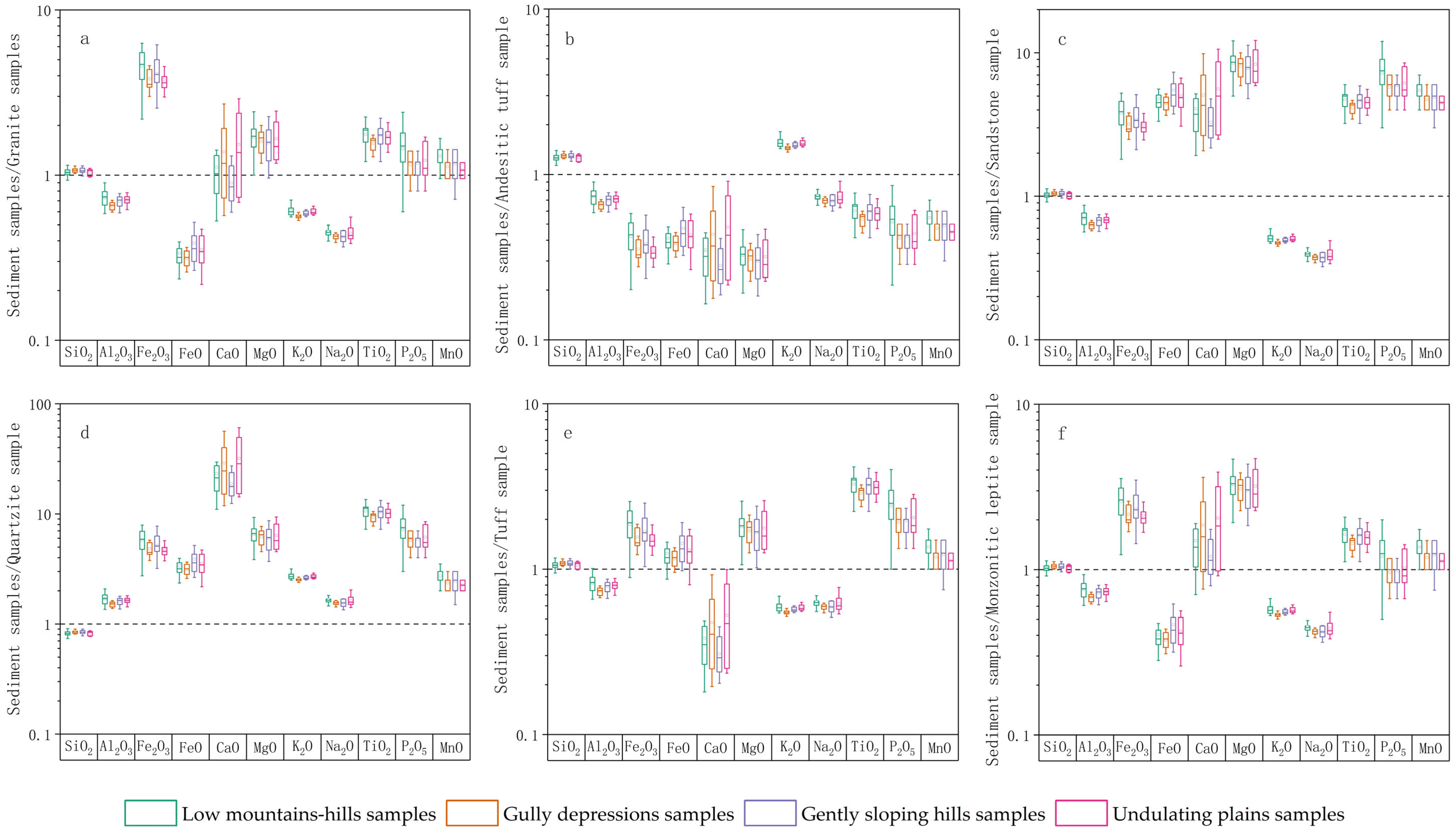
The observed similarities in major element composition and generally low coeffi-cients of variation (CV) across the four geomorphic units (low mountains-hills, gully depressions, gently sloping hills, and undulating plains) may suggest the influence of regional-scale homogenizing processes. To investigate this, the geochemistry of sediments from these units was collectively normalized against various local bedrock types (Figure 2).
The resulting patterns are complex, as the apparent enrichment or depletion of a given element is highly dependent on the specific bedrock comparator. For instance, when normalized against felsic rocks like granite, sediments frequently show relative enrichment in elements such as Fe2O3, MgO, TiO2, and also CaO. Conversely, normalization against a more mafic end-member, such as andesitic tuff, typically yields a pattern of depletion for these same elements. This contrasting behavior could be interpreted as evidence that the sediments are not derived from a single source but may represent a mixture of materials from different local bedrocks.
From a mineralogical perspective, the consistent relative enrichment of SiO2 across all units likely points to the residual accumulation of weathering-resistant quartz. The behavior of CaO appears complex, potentially reflecting a balance between the input of calcium from sources like calcite or calcic plagioclase and its removal via leaching. The generally more pronounced depletion of Na2O compared to K2O might reflect the higher susceptibility of sodic plagioclase to chemical weathering compared to the relative stability of K-feldspar and micas. The variable behavior of elements like Fe, Mg, and Ti could be related to the distribution and stability of ferromagnesian minerals and heavy minerals during transport and sorting.
In summary, the geochemical signatures of the sediments across the four geomorphic units exhibit a convergent pattern. This convergence, viewed in the context of significant heterogeneity in the local bedrock geochemistry, is best explained by a model of substantial sediment mixing from multiple local sources. The composition of the surface sediments thus appears to represent an integrated average of the diverse lithologies present in the study area.
Compared to major elements, trace elements demonstrate higher environmental sensitivity and serve as more effective provenance indicators. Statistical analysis of 15 trace elements (Cu, Pb, Zn, Cr, Ni, Co, Rb, Sr, Ba, V, Nb, Zr, Ce, Nd, Y) in surface sediments from four geomorphic units (gully depressions, low mountains-hills, gently sloping hills, and undulating plains) reveals distinct concentration patterns (Appendix A): Ba (504.36–684.50 μg g−1; CV: 0.121–0.225), Sr (172.39–236.27 μg g−1; CV: 0.08–0.16), Zr (183.18–207.61 μg g−1; CV: 0.08–0.206), and Rb all exceed 100 μg g−1 on average, where Ba shows the highest abundance and Sr/Zr ratios exhibit stable spatial distributions. Elements including Cu, Pb, Zn, Cr, Ni, V, Ce, Nd, and Y exhibit moderate concentrations ranging from 10 to 100 μg g−1.
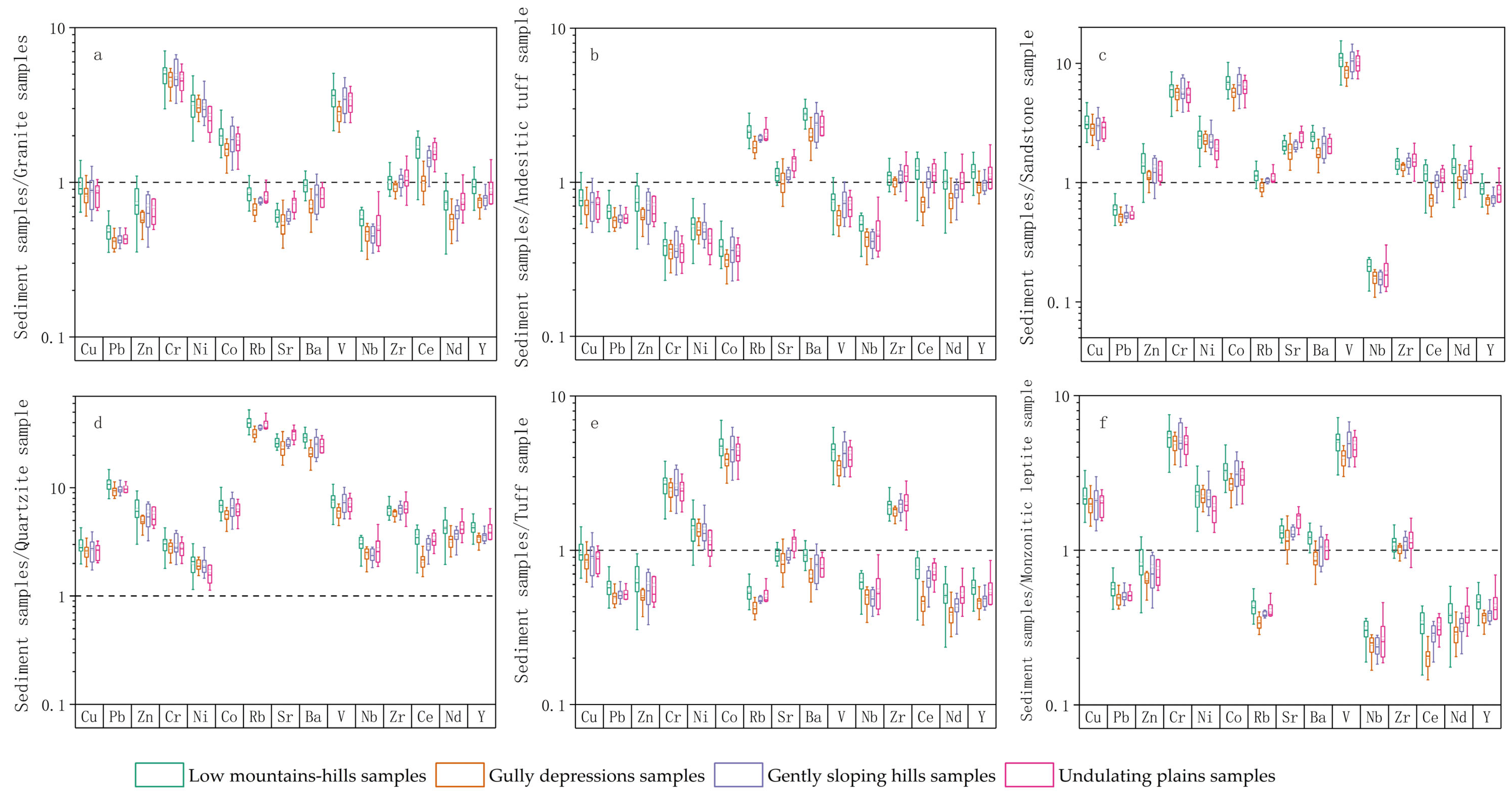
The trace elements in sediments from the four geomorphic units—low mountains-hills, gully depressions, gently sloping hills, and undulating plains—exhibit systematic distribution patterns when normalized against local bedrock, consistent with the results of major element analysis. The apparent enrichment or depletion of any trace element is not absolute but demonstrates significant variation depending on the specific reference bedrock (Figure 3).
Relative to granite, the sediments from these four units show enrichment in Cr, Ni, Co, V, and Zr, accompanied by depletion in Sr and Nb, while Rb concentrations remain near equilibrium values. In contrast, when compared to andesitic tuff, the same sediments display depletion in Cr, Ni, Co, and V, alongside clear enrichment in Rb and Ba. Relative to sandstone, the enrichment of Cr, Ni, Co, and V is particularly pronounced, and Zr also shows an enrichment trend; meanwhile, Rb levels remain close to equilibrium, while Ba exhibits stable enrichment. Against quartzite, the sediments demonstrate enrichment in nearly all trace elements, consistent with the highly purified nature of this end-member. When normalized against tuff and monzonitic leptite, the sediments generally show enrichment in Cr, Ni, Co, and V, while Rb exhibits depletion, with some samples approaching equilibrium and others showing clear depletion.
From a mineralogical perspective, the marked enrichment of Cr, Ni, V, and Co relative to granite and sandstone likely reflects significant contributions from ferromagnesian minerals and accessory minerals. The enrichment trend of Zr may be associated with the concentration of zircon and other stable heavy minerals. Conversely, the enrichment characteristics of Rb and Ba relative to andesitic tuff indicate inputs from K-feldspar and mica derived from felsic rocks. This systematic geochemical behavior suggests that the composition of the sediments across the four geomorphic units is not controlled by a single source rock but rather reflects physical mixing of components derived from both felsic and mafic bedrock end-members. The limited variability of these patterns among the different geomorphic units further indicates that this mixing process was regionally extensive.

4.2. Characteristics of Chemical Weathering

The Chemical Index of Alteration (CIA) robustly quantifies silicate weathering intensity [34], calculated as:
CIA = [Al2O3/(Al2O3 + CaO* + Na2O + K2O)] × 100 (molar proportions)
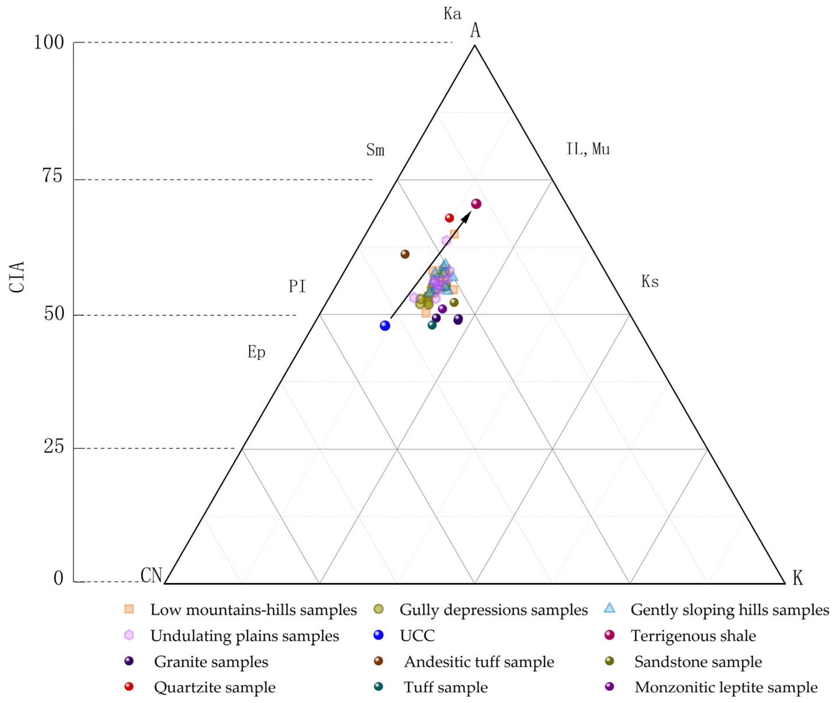
where CaO* represents the CaO content in silicate minerals following the carbonate correction method of McLennan. A-CN-K ternary diagram analysis of four geomorphic units (low mountains-hills, gently sloping hills, gully depressions, and undulating plains) revealed clustered CIA values averaging 63.7 (range: 60 to 70), indicating low-to-moderate silicate weathering intensity under cold/arid climatic conditions (Figure 4) [35]. Notably, gully depressions samples exhibited the lowest CIA values, suggesting weaker chemical weathering compared to other units. This spatial weathering gradient reflects the combined controls imposed by climate (moisture/temperature limitations), parent lithology, and sedimentary processes, and aligns with regional paleoenvironmental reconstructions [36].
Analysis of the regional bedrock endmembers reveals their distinct weathering characteristics: samples of granite, sandstone, tuff, and monzonitic leptite are predominantly located in areas indicative of weak chemical weathering on the A-CN-K diagram, whereas the andesitic tuff and quartzite samples plot within regions of intermediate to high intensity weathering. Most of the surface sediments in the study area cluster closely with the granite, sandstone, tuff, and monzonitic leptite, suggesting that these local rocks could be the primary sources of the sedimentary material. In contrast, the andesitic tuff and quartzite show clear compositional separation from the sediment cluster, indicating their likely limited contribution to the sediments in the study area.

4.3. Provenance Analysis

4.3.1. Elemental Comparative Analysis

The chemical composition of sediments, including major oxides and trace elements, provides reliable indicators for provenance analysis [37]. In this study, elemental correlation methods were employed to investigate surface sediment sources in the Kangbao region by comparing their geochemical signatures with a range of potential source materials. These include Jurassic tuff, Permian andesitic tuff and sandstone, Permian intrusive granite, Paleoproterozoic quartzite, Neoarchean monzonitic leptite, and sediments from the Hunshandake Sandy Land [38]. This analysis was conducted with consideration of both regional geological settings and geomorphological contexts [39].
Comparative analysis of major and trace element ratios reveals a fundamental geochemical distinction between the sediments of the Hunshandake Sandy Land and those from the four local geomorphic units (low mountains-hills, gully depressions, gently sloping hills, and undulating plains) (Figure 5). The local sediments exhibit significant coherence in key ratios. SiO2/Al2O3 and Na2O/K2O ratios indicate comparable silicate weathering intensities [40]. The generally lower and less variable Zr/Nb ratios in these local units are consistent with a common provenance dominated by local bedrock. However, this coherence primarily reflects the overarching control of regional bedrock lithologies on the initial sediment composition [41]. The similar geochemical signatures across different geomorphic units likely indicate that their respective parent materials are derived from a comparable suite of local bedrock types. In contrast, Hunshandake Sandy Land sediments exhibit distinctly different signatures characterized by exceptionally high SiO2/Al2O3 and Zr/Nb ratios, reflecting typical aeolian sand characteristics involving intense weathering, high mineral maturity, and a different provenance [42].
While bedrock properties exert the primary control on bulk sediment composition, geomorphic units play a critical role in causing secondary geochemical differentiation. This is evidenced by variations in certain mobile element ratios (e.g., Ba/Sr, Rb/Sr) among the four local units, which are primarily controlled by fractionation during weathering, transport, and deposition [43]. Variations in the Nd/Y ratio, which is sensitive to the fractionation between light and heavy rare earth elements, further support the influence of these secondary processes, such as chemical weathering and mineral sorting, in modifying the original geochemical signature imparted by the bedrock.
In summary, element ratio analysis demonstrates that the surface sediments within the study area originate predominantly from the weathering of local bedrock. The geochemical differentiation observed among geomorphic units is therefore interpreted as a two-stage process: primarily governed by the properties of the underlying or proximal bedrock, and subsequently modified by landform-specific weathering-hydrogeochemical processes. Significant external aeolian input from the Hunshandake Sandy Land appears negligible, given its distinctly different geochemical fingerprint.

4.3.2. Multivariate Statistical Analysis

Multivariate statistical approaches, including principal component analysis (PCA) and Non-metric Multidimensional Scaling (nMDS), were employed for provenance discrimination following the validated methodology of Zhang et al. [32]. The analysis incorporated ten stable elemental ratios—SiO2/Al2O3, Na2O/K2O, K2O/Al2O3, Na2O/Al2O3, Zr/Nb, Ba/Sr, Rb/Sr, Nd/Y, and Cr/V—selected for their geochemical robustness in sedimentary systems.
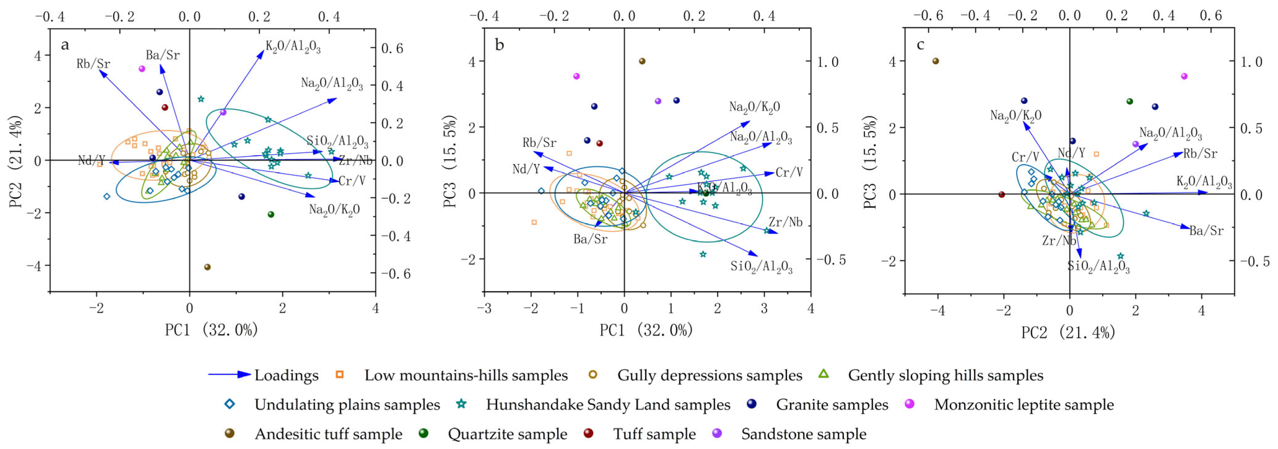
Principal component analysis (PCA) extracted three principal components (PCs) to characterize the geochemical signatures of surface sediments from various geomorphic units in the Kangbao region and the Hunshandake Sandy Land, collectively explaining 68.9% of the total variance (Table 2).
PC1 (32.0%) represents the primary gradient of chemical weathering intensity and sediment maturity. This component is strongly defined by positive loadings of Zr/Nb and Cr/V, which robustly indicate the enrichment of weathering-resistant heavy minerals [44]. PC2 (21.4%) is defined by strong positive loadings for K2O/Al2O3, Rb/Sr, and Ba/Sr, reflecting the physical concentration of K-bearing minerals through hydrodynamic sorting [45]. PC3 (15.5%) captures a distinct geochemical process characterized by the strongest absolute loadings in the analysis: a very strong positive loading of Na2O/K2O and a very strong negative loading of SiO2/Al2O3. This pattern highlights the fractionation between sodium and potassium (albite enrichment) coupled with quartz dilution, a process largely controlled by source mineralogy and weathering conditions [46]. Notably, the SiO2/Al2O3 ratio exhibits significant cross-loadings, contributing positively to PC1 but exerting its dominant influence negatively on PC3. This can be interpreted to reflect the dual controls on quartz enrichment: it is a general indicator of overall sediment maturity (thus its association with PC1), but its most significant variability is specifically tied to the alkali-feldspar fractionation process captured by PC3. The same applies to Na2O/Al2O3, which loads positively on both PC1 and PC3, affirming its role in both maturity and albite-specific trends.
The spatial distribution map of principal component scores (Figure 6) clearly reveals the geochemical differentiation among different geomorphic units. In the factor space composed of PC1 and PC2 (Figure 6a), the geomorphic units exhibit systematic distribution patterns: sediments from low mountains and hills show the weakest chemical weathering intensity (strongly negative PC1) and highly variable hydrodynamic conditions (dispersed PC2); gully depressions are in a transitional weathering state (PC1 near zero) with strong hydrodynamic heterogeneity (broad PC2 distribution range) [47]; undulating plains display the weakest weathering intensity (strongly negative PC1) and the most stable hydrodynamic environment (strongly negative PC2); while the Hunshandake Sandy Land exhibits the strongest chemical weathering and highest sediment maturity (strongly positive PC1), accompanied by an active hydrological regime (predominantly positive PC2). Notably, in the projection formed by PC1 and PC3 (Figure 6b), the sediments of the Hunshandake Sandy Land also show relatively high positive PC3 scores, further confirming that this area not only has high overall maturity but has also undergone significant albite enrichment and quartz dilution processes. This spatial distribution pattern collectively confirms the existence of distinct, landform-controlled weathering-hydrodynamic geochemical coupling mechanisms within the study area.
Non-metric Multidimensional Scaling (nMDS) analysis (Stress = 0.1203, meeting the reliability threshold of <0.2) effectively captured complex geochemical differentiation among samples through dimensionality reduction. The nMDS1 axis revealed clear spatial segregation: positive values were predominantly associated with samples from low mountains-hills, gently sloping hills, and undulating plains within the study area, while negative values were primarily occupied by samples from the Hunshandake Sandy Land. Notably, gully depression samples predominantly clustered within the low negative to near-zero range of nMDS1, indicating a distinct geochemical signature. This overall pattern indicates a fundamental geochemical divergence between the aeolian sands of the sandy land and local sedimentary deposits. The nMDS2 axis further differentiated sediment types, with undulating plain samples generally plotting in positive values, whereas a subset of low mountains-hills samples extended into negative values, suggesting additional environmental or provenance controls.
The nMDS ordination plot (Figure 7) demonstrates that:
(1) Samples from low mountains-hills and gently sloping hills show broad overlap in the nMDS1-positive region, but are clearly separated from the Hunshandake Sandy Land cluster which occupies nMDS1-negative values;
(2) Gully depression samples form a relatively clustered group within the low negative to near-zero range of the nMDS1 axis, yet remain spatially distinct from the Hunshandake Sandy Land cluster, indicating a unique geochemical character that differs from both the local sediments and the aeolian sands;
(3) Undulating plain samples are predominantly located in the nMDS2 positive domain, showing partial vertical overlap with but clear horizontal separation from the sandy land cluster along nMDS1, reflecting their distinct geochemical signatures;
(4) Bedrock samples exhibit extreme dispersion across the ordination space, underscoring substantial lithological heterogeneity among source rocks.
Collectively, these patterns highlight the dominant role of local sediment sources and depositional controls across geomorphic units. Integrated analyses establish the Hunshandake Sandy Land as a potential allochthonous aeolian depositional system characterized by intense weathering and felsic provenance, fundamentally contrasting with the weakly weathered, bedrock-dominated sedimentary regime in the study area. Combined PCA and nMDS evidence demonstrates negligible compositional influence from sandy land materials on surface sediments across geomorphic units, with observed geochemical differentiation being primarily governed by bedrock properties and local weathering-hydrogeochemical processes [48].
Figure 7. The nMDS diagram comparing samples from different geomorphic units with potential source materials.
Applsci 15 11785 g007

5. Discussion

5.1. Dominance of Bedrock Provenance and Its Geomorphic Modification

The spatial distribution of samples in the elemental ratio diagrams (Figure 5), PCA (Figure 6), and nMDS (Figure 7) provides direct evidence for sediment pro [49]. If the sediments in each geomorphic unit were primarily derived from a single local bedrock type, the sample points would form discrete clusters around their respective source rocks. However, the actual distribution reveals a markedly different pattern: the bedrock samples are highly dispersed, reflecting the inherent lithological diversity of the region, whereas all sediment samples form a relatively continuous and cohesive cloud within the compositional space defined by these bedrock endmembers, with no discrete clustering according to local bedrock type. This configuration is a classic signature of sedimentary mixing, indicating that weathering products from diverse lithologies have been thoroughly blended across the study area, forming a regionally homogenized sediment reservoir. The clear separation of this sediment cloud from the Hunshandake Sandy Land samples further confirms the dominance of this local, mixed provenance and rules out significant external inputs.
Building upon this homogenized foundation, geomorphic processes act as the primary driver for secondary geochemical differentiation. The sediment samples exhibit systematic yet subtle differentiation within the cohesive cloud, showing a good correlation with specific geomorphic units and reflecting the distinct weathering-transport-deposition regimes they control: Low mountains-hills and gently sloping hills, as source terrains, exhibit signatures of limited chemical alteration, consistent with their erosional topography and short transport distances. From a mineralogical perspective, the relative enrichment of primary minerals such as quartz and K-feldspar, coupled with the low preservation of easily weathered minerals like calcic plagioclase in the sediments of these areas, collectively supports the interpretation that they have undergone relatively weak chemical weathering. Gully depressions, functioning as convergence zones, show evidence of hydrodynamic sorting, as indicated by variations in mobile element ratios such as Ba/Sr and Rb/Sr. This likely reflects the separation and enrichment of sheet-like or low-density minerals rich in Rb and Ba, such as mica and K-feldspar, from other minerals during the hydrodynamic sorting process. Undulating plains display characteristics suggestive of aeolian influence, including the relative enrichment of weathering-resistant minerals. Mineralogically, this may be reflected in the relative concentration of stable heavy minerals such as zircon and rutile, a typical result of aeolian winnowing of fine-grained, light-weight components.
In conclusion, t the geochemical data support a two-stage genetic model: first, the creation of a homogenized sediment reservoir through the mixed weathering of regional bedrock, establishing a common provenance foundation; followed by the modification of this shared source by landform-specific geomorphic processes, which imparts the distinctive, albeit subtle, geochemical signatures observed across different geomorphic units. This model highlights the complete chain from the “source” control of regional bedrock mixing to the “sink” modification of sediment composition by local geomorphic processes.

5.2. Interpretation of Sediment Modification Processes

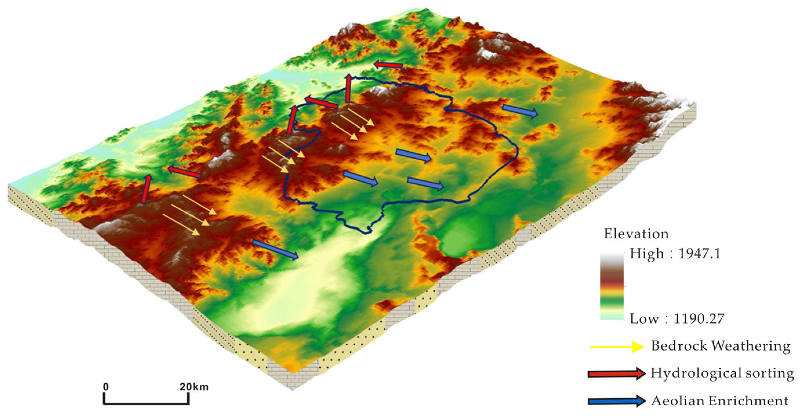
Building on the conclusion that sediments originate from a mixed regional bedrock provenance, the spatial variation in geochemical signatures elucidates the subsequent transport pathways and modification processes. This study synthesizes the evidence into a conceptual framework of “in-situ weathering—hydrological sorting—aeolian enrichment” to describe the localized sediment cycling mechanism in the Kangbao region (Figure 8).
(1) In-situ Weathering and Release. The initial stage involves the physical weathering of the diverse regional bedrock assemblage (e.g., Permian granites, Neoarchean metamorphic rocks). The geochemical signatures in the low mountains and hills, such as specific SiO2/Al2O3, Na2O/K2O, and Cr/V ratios (Figure 5), correspond to the composition of this blended source. The low chemical index of alteration (CIA) values is consistent with limited chemical weathering and short-distance transport of the detrital material from these source terrains.
(2) Hydrological Convergence and Sorting. Weathered materials are subsequently transported from hillslopes to gully depressions through runoff processes. The geochemical differentiation in these convergence zones is primarily governed by hydraulic sorting, as evidenced by systematic variations in mobile element ratios. The decreases in Ba/Sr ratios alongside increases in Rb/Sr ratios reflect selective enrichment of fine-grained minerals, particularly clay minerals and micas. Concurrent changes in rare earth element patterns further confirm hydrodynamic fractionation during transport.
(3) Aeolian Modification and Redistribution. The undulating plains represent the terminal stage where aeolian processes winnow and modify previously deposited sediments. This is demonstrated by significant enrichment of resistant heavy minerals, as indicated by elevated Zr concentrations and characteristic Nd/Y ratios. These patterns reflect wind-driven concentration processes influenced by NW monsoons and potentially enhanced by anthropogenic disturbances [50].
Critically, the complete separation between all local samples and the Hunshandake Sandy Land in the PCA and nMDS plots (Figure 6 and Figure 7) supports that the aeolian materials are derived from the in-situ reworking of local sediments rather than external input. This framework illustrates an “in-situ activation—localized cycling” aeolian regime, where the geomorphic pathways dictate the final provenance signature at any given location.

5.3. Implications for Desertification Control in Agro-Pastoral Ecotones

Provenance analysis confirms that the surface sediments in the Kangbao region are primarily derived from local bedrock weathering. Integrating the identified sediment transport pathways across geomorphic units, a zonal management strategy focused on source control [51,52] is recommended to disrupt the sequential “weathering–sorting–enrichment” desertification process.
(1) Source Interception in Hilly Areas. In erosion-prone hilly terrains, the establishment of deep-rooted shrubs (e.g., Caragana korshinskii) is recommended to stabilize weathering debris [53,54,55]. These efforts should be integrated with Grain-for-Green programs to minimize the release of fresh detrital material. Given the high mobility of weathering products indicated by PCA, the construction of cascaded gravel barriers can further mitigate runoff transport efficiency.
(2) Ecological Restoration in Gully Depressions. Leveraging the natural material convergence characteristics of these areas, a combined “hydrological regulation–salinization control” system should be implemented. Planting salt-tolerant forage species (e.g., Achnatherum splendens) along depression margins can help lower groundwater tables, while the construction of rainwater harvesting and recharge systems in central zones can suppress the emission of saline dust [56].
(3) Pathway Interception on Undulating Plains. In plains areas characterized by Zr-enriched sediments, the installation of tall straw checkerboards is effective for increasing surface roughness and trapping windborne sand. The concurrent adoption of conservation tillage practices will help stabilize the Zr-rich surface layers and prevent the remobilization of wind-resistant minerals [57].

5.4. Limitations

While the core conclusions remain robust, this study exhibits limitations in data depth, methodological integration, and provenance transport dynamics. Three primary constraints are noted:
(1) A key limitation of this work is that the geochemical data alone, while critical for establishing provenance, are insufficient for constructing a comprehensive desertification classification model. Such an endeavor necessitates complementary time-series data on vegetation and soil properties typically derived from remote sensing and field surveys.
(2) The analysis of human activity impacts on geochemical elements was somewhat underrepresented. Future research should incorporate land-use type analysis to examine correlations between spatial anomalies of geochemical elements and human activities.
(3) The absence of systematic grain-size and mineralogical (e.g., XRD) analyses for the samples represents another limitation. Grain-size composition serves as a critical indicator of sedimentary dynamics, while mineralogical characterization is essential for accurately identifying sediment provenance and weathering processes. Future studies should focus on integrating grain-size distribution with mineralogical analyses across different geomorphic units, enabling a more precise quantification of the relative contributions of aeolian and fluvial processes to sediment sorting and a clearer interpretation of transport and weathering history.

6. Conclusions

This study systematically analyzed the geochemical characteristics of surface sediments from distinct geomorphic units in the Kangbao region, integrating elemental ratios, multivariate statistics, and regional geology to clarify sediment provenance, differentiation mechanisms, and implications for desertification control. The main conclusions are as follows:
(1) Geochemical characteristics reveal that sediment elemental enrichment or depletion patterns exhibit fundamental differences depending on the specific bedrock reference. When normalized against felsic versus mafic end-members, elements including Fe2O3, MgO, TiO2, CaO, Cr, Ni, Co, V, Rb, and Ba demonstrate contrasting geochemical behaviors. The sediments across all local geomorphic units are derived from a homogenized mixture resulting from the weathering of the regional bedrock assemblage. This common provenance is fundamentally distinct from the external, high-maturity aeolian sands of the Hunshandake Sandy Land, confirming that desertification in the study area is primarily driven by the local activation of indigenous materials.
(2) The spatial geochemical differentiation of surface sediments across geomorphic units is interpreted as a two-stage process: the initial formation of a homogenized sediment source from the mixing of regional bedrock weathering products, followed by the subtle modification of this common material by landform-specific geomorphic processes. This is manifested as limited weathering in erosional hillslopes, hydrological sorting in gully depressions, and aeolian enrichment on the undulating plains, resulting in the weak but systematic geochemical variations observed across the landscape.
(3) Based on the proven dominance of local provenance and its geomorphic transport pathways, a zonal management strategy is proposed, targeting key stages of the sediment cycle: intercepting weathered material at the source in hilly areas, stabilizing and restoring convergence zones in gully depressions, and blocking aeolian transport pathways on the plains to disrupt the localized desertification feedback loop.

Author Contributions

Conceptualization, Y.B. and H.L.; methodology, Y.B. and H.L.; software, Y.B.; validation, Y.B. and Y.X.; formal analysis, Y.B. and H.L.; investigation, Y.B., H.L. and Z.L.; resources, Y.B. and H.L.; data curation, D.X.; writing—original draft preparation, Y.B.; writing—review and editing, Y.B. and H.L.; visualization, Z.L.; supervision, J.M., F.Y. and N.W.; project administration, H.L.; funding acquisition, Y.B. All authors have read and agreed to the published version of the manuscript.

Funding

This research was funded by the China Geological Survey, grant numbers DD20221727 (Resource and Environmental Carrying Capacity Monitoring and Assessment of the Beijing-Tianjin-Hebei Collaborative Development Zone and Xiong’an New Area), DD20230801202 (Resource and Environmental Carrying Capacity Monitoring and Assessment of National Major Regional Development Strategy Zones), and DD20190820 (Comprehensive Geological Survey of the Zhangjiakou Area, Hebei Province).

Institutional Review Board Statement

Not applicable.

Informed Consent Statement

Not applicable.

Data Availability Statement

The original contributions presented in this study are included in the article. Further inquiries can be directed to the corresponding author(s).

Conflicts of Interest

The authors declare that they have no conflict of interest regarding the publication of this paper.

Appendix A

Table A1. Statistical summary of trace element concentrations in surface sediments from different geomorphic units.
CuPbZnCrNiCoRbSrBaVNbZrCeNdY
Gully depressionsMax21.6022.6032.2045.4024.006.96128.00243.00652.0049.3012.90199.0046.5022.8018.80
Min11.8015.9021.0027.9016.204.1959.30119.00342.0031.205.72153.1624.3011.7011.00
Mean16.2618.7328.1238.5120.285.7993.02172.39504.3641.328.49183.1834.1316.6214.34
CV0.190.120.130.150.130.150.180.210.160.140.220.080.190.190.16
Low mountains-hillsMax27.0031.9053.9064.8032.0010.70194.00232.00853.0082.1020.80262.87100.0033.4028.40
Min8.9215.8017.4019.3012.103.2290.70163.00547.0025.504.96110.6526.2010.008.32
Mean17.9821.9236.0143.0821.147.22122.31191.64684.553.110.76196.3557.2321.617.97
CV0.270.190.270.260.250.270.210.110.120.230.300.170.270.240.24
Gently sloping hillsMax24.7023.4076.6055.6029.609.63112.00213.00814.0070.309.68239.0058.1022.4018.90
Min11.0016.7018.7027.0015.304.3899.50170.00412.0036.006.26159.9831.8012.209.92
Mean17.2619.4534.7641.0920.836.98105.23190.09594.7351.468.21199.4148.0918.6414.86
CV0.250.110.450.240.210.240.040.080.230.220.130.120.160.150.17
Undulating plainsMax33.9027.3068.0073.6031.9013.80144.00279.00717.0097.6015.70289.7483.2032.6026.60
Min12.8017.9024.3027.6011.904.44102.00184.00494.0035.906.43139.2439.7015.9013.70
Mean17.6620.0033.8840.2617.866.97111.46236.27582.6451.679.23207.6155.4922.2416.88
CV0.330.140.370.320.300.360.120.130.140.330.290.200.220.210.23
Granite samplesMax34.0082.5061.4012.7013.005.55160.00495.00983.4023.6023.80266.9041.7641.7622.10
Min11.6021.1024.605.802.901.02110.85153.50579.308.1014.9098.8724.209.8612.90
Mean19.5044.8749.108.336.563.65139.28317.26719.5614.8018.00196.0533.9429.1618.99
CV0.640.730.430.450.850.640.180.540.310.530.270.440.260.580.27
Monzonitic leptite sample 8.2538.1044.207.829.142.23273.00146.00569.0010.4034.30180.14168.0057.1038.50
Andesitic tuff sample 23.3033.1047.20108.0040.8019.1054.80171.00247.0069.8019.58183.8246.5021.4015.20
Sandstone sample 5.7836.2025.506.968.901.05102.0093.80282.704.8652.50135.8547.1016.2020.10
Quartzite sample 6.311.995.7713.810.51.062.947.3623.66.963.4231.6916.105.104.15
Tuff sample 19.0037.4056.8015.6015.101.54220.00206.00740.0012.0016.80103.0074.2042.6031.00

References

  1. Zan, G.S.; Wang, C.P.; Li, F.; Liu, Z.; Sun, T. Key Data Results and Trend Analysis of the Sixth National Survey on Desertification and Sandification. For. Grassl. Resour. Res. 2023, 1, 1–7. [Google Scholar]
  2. Wang, X.M.; Zhang, C.X.; Hasi, E.; Dong, Z.B. Has the Three Norths Forest Shelterbelt Program solved the desertification and dust storm problems in arid and semiarid China? J. Arid Environ. 2010, 74, 13–22. [Google Scholar] [CrossRef]
  3. Yuan, J.G.; Wang, W.; Long, L.M. Land Degradation and Ecological Reconstruction of Eco-fragile Region in Bashang of Hebei Province. J. Arid Land Resour. Environ. 2006, 20, 139–141. [Google Scholar]
  4. Xie, Y.Y.; Yuan, F.; Zhan, T.; Kang, C.G.; Chi, Y.P. Geochemical and isotopic characteristics of sediments for the Hulun Buir Sandy Land, northeast China: Implication for weathering, recycling and dust provenance. Catena 2018, 160, 170–184. [Google Scholar] [CrossRef]
  5. Li, Z.P.; Yue, L.P.; Xue, X.X.; Yang, L.R.; Nie, H.G. Characteristics of land desertifications of different origins on the southeastern margin of the Mu Us desert. Geol. Bull. China 2006, 25, 590–596. [Google Scholar]
  6. Wang, Z.L.; Wei, X.F.; Wei, H.; Li, X. The grain size characteristics of different sedimentary units and the effects of desertification in the Xiaoluan River Basin in Bashang, Hebei. Miner. Explor. 2021, 12, 1000–1007. [Google Scholar]
  7. Liu, Q.Q.; Yang, X.P. Geochemical composition and provenance of aeolian sands in the Ordos Deserts, northern China. Geomorphology 2018, 318, 354–374. [Google Scholar] [CrossRef]
  8. Cui, Y.C.; Cao, L.C.; Qiao, P.J.; Chen, S.H.; Pang, X.; Shao, L. Provenance Evolution of Paleogene Sequeence (Northern South China Sea) Based on Detrital Zircon U-Pb Dating Analysis. Earth Sci. 2018, 43, 4169–4179. [Google Scholar]
  9. Chen, J.; Li, G.J. Geochemical studies on the source region of Asian dust. Sci. China Earth Sci. 2011, 54, 1279–1301. [Google Scholar] [CrossRef]
  10. Nesbitt, H.W.; Young, G.M. Early Proterozoic climates and plate motions inferred from major element chemistry of lutites. Nature 1982, 299, 715–717. [Google Scholar] [CrossRef]
  11. McLennan, S.M. Weathering and global denudation. J. Geol. 1993, 101, 295–303. [Google Scholar] [CrossRef]
  12. Hu, F.G.; Yang, X.P. Geochemical and geomorphological evidence for the provenance of aeolian deposits in the Badain Jaran Desert, northwestern China. Quat. Sci. Rev. 2016, 131, 179–192. [Google Scholar] [CrossRef]
  13. Garzanti, E.; Andò, S.; Vezzoli, G. Grain-size dependence of sediment composition and environmental bias in provenance studies. Earth Planet. Sci. Lett. 2009, 277, 422–432. [Google Scholar] [CrossRef]
  14. Numanami, N.; Takeshi, O.; Muga, Y. Principal component analysis for the elemental composition of sedimentary sands in the Hayakawa River of Hakone Caldera, Japan. Geochem. J. 2024, 58, 155–168. [Google Scholar] [CrossRef]
  15. Traore, A.; Mao, X.; Traore, A.; Yakubu, Y.; Sidibe, A.M. Multivariate Statistical Analysis of Dominating Groundwater Mineralization and Hydrochemical Evolution in Gao, Northern Mali. J. Earth Sci. 2024, 35, 1692–1703. [Google Scholar] [CrossRef]
  16. Vermeesch, P. Multi-sample comparison of detrital age distributions. Chem. Geol. 2013, 341, 140–146. [Google Scholar] [CrossRef]
  17. Song, Y.G.; Chen, X.L.; Li, Y.; Fan, Y.F.; Collins, A.L. Quantifying the provenance of dune sediments in the Taklimakan Desert using machine learning, multidimensional scaling and sediment source fingerprinting. Catena 2022, 210, 105902. [Google Scholar] [CrossRef]
  18. Bai, Y.N.; Liu, H.W.; Ma, Z.; Jiang, W.J.; Miao, J.J.; Du, D. Characteristics of land desertification and its geological influencing factors in northern Kangbao County. N. China Geol. 2020, 3, 212–217. [Google Scholar]
  19. Wang, X.J.; Guan, X.Y.; Zhang, D.S.; Zhu, G.X.; Wang, D.Q.; Ban, C.Y. Geological Characters of the Cenozoic Red Beds in Zhangbei-Kangbao Region, Northwestern Hebei Province. Geol. Surv. Res. 2005, 28, 39–46. [Google Scholar]
  20. Pei, H.W.; Liu, M.Z.; Li, Y.L.; Li, H.J.; Xiao, Y.Y.; Yang, G.L. Impact of Ecological Restoration Measures on Ecosystem Services in Arid and Semi-arid Area. Res. Soil Water Conserv. 2022, 29, 192–199. [Google Scholar]
  21. Yang, Y.; Yang, Y.; Wu, Z.; Guo, C.; Sun, B.; Cheng, F. Studies on Wind Break and Sand Fixation Effects of Farmland Shelterbelt in Bashang Area of Northern Hebei. J. Northwest For. Univ. 2020, 35, 167–172. [Google Scholar]
  22. Yu, Y.; Wu, L.; Wang, N.; Wu, L.Y. Uncertainty evaluation of 15 Rare Earth Elements in rock by ICP-MS. N. China Geol. 2024, 47, 105–110. [Google Scholar]
  23. McLennan, S.M. Relationships between the trace element composition of sedimentary rocks and upper continental crust. Geochem. Geophys. Geosystems 2001, 2, 1021. [Google Scholar] [CrossRef]
  24. Madukwe, H.Y.; Obasi, R.A. Geochemistry, classification and maturity of the sandstone facies of the Abeokuta Formation, South Western Nigeria. Eur. J. Basic Appl. Sci. 2016, 3, 39–57. [Google Scholar]
  25. Sultana, S.; Rashid, S. Geochemistry and clay mineral studies of Jurassic sedimentary rocks from the Spiti region, Himachal Pradesh, North India. J. Indian Assoc. Sedimentol. 2022, 39, 17–29. [Google Scholar] [CrossRef]
  26. Dinis, P.; Garzanti, E.; Hahn, A.; Vermeesch, P.; Cabral-Pinto, M. Weathering indices as climate proxies. A step forward based on Congo and SW African river muds. Earth-Sci. Rev. 2020, 201, 103039. [Google Scholar] [CrossRef]
  27. Chang, C.; Beckford, H.O.; Ji, H. Indication of Sr Isotopes on Weathering Process of Carbonate Rocks in Karst Area of Southwest China. Sustainability 2022, 14, 4822. [Google Scholar] [CrossRef]
  28. Li, B.; Jin, X.; Dal Corso, J.; Ogg, J.G.; Lang, X.; Baranyi, V.; Preto, N.; Franceschi, M.; Qiao, P.; Shi, Z. Complex pattern of environmental changes and organic matter preservation in the NE Ordos lacustrine depositional system (China) during the T-OAE (Early Jurassic). Glob. Planet. Chang. 2023, 221, 104045. [Google Scholar] [CrossRef]
  29. Mueller, M.A.; Licht, A.; Möller, A.; Condit, C.B.; Fosdick, J.C.; Ocakoğlu, F.; Campbell, C. An expanded workflow for detrital rutile provenance studies: An application from the Neotethys Orogen in Anatolia. EGUsphere 2023, 1–44. [Google Scholar] [CrossRef]
  30. Patra, A.; Shukla, A.D. Geochemical signatures of Late Paleocene sandstones from the Sanu Formation, Jaisalmer basin, western India: Implication for provenance, weathering and tectonic setting. J. Earth Syst. Sci. 2020, 129, 81. [Google Scholar] [CrossRef]
  31. Aitchison, J.; Greenacre, M. Biplots of compositional data. J. R. Stat. Soc. Ser. C 2002, 51, 375–392. [Google Scholar] [CrossRef]
  32. Zhang, Z.C.; Pan, K.J.; Zhang, C.X.; Liang, A.M. Geochemical characteristics and the provenance of aeolian material in the Hexi Corridor Desert, China. Catena 2020, 190, 104483. [Google Scholar] [CrossRef]
  33. Li, X.M.; Liu, X.K.; Yan, P. Spatial variability of the physicochemical characteristics of surface sediments in the “Three Rivers and One Dune” Region in the Kuye River Basin, Mu Us Sandy Land, China. Catena 2022, 210, 105943. [Google Scholar] [CrossRef]
  34. Thorn, C.E.; Darmody, R.G.; Dixon, J.C. The chemical weathering regime of Kärkevagge, arctic-alpine Sweden. Geomorphology 2001, 41, 37–52. [Google Scholar] [CrossRef]
  35. Chen, Q.J. The Spatial Distribution of Geochemical Composition of Eolian Sediments in the Alashan Desert and Its Environmental Sensitivity. Ph.D. Thesis, Lanzhou University, Lanzhou, China, 2023. [Google Scholar]
  36. Liu, L.; Xie, Y.Y.; Chi, Y.P.; Kang, C.G.; Wu, P.; Wei, Z.Y.; Zhang, Y.X.; Zhang, M. Geochemical compositions of the Onqin Daga Sand Land and Horqin Sand Land and their implications for weathering, sedimentation and provenance. Mar. Geol. Quat. Geol. 2021, 41, 192–206. [Google Scholar]
  37. Wang, K.; Zhai, S.K. Geochemical methods for identification of sedimentary provenance. Mar. Sci. 2020, 44, 132–143. [Google Scholar]
  38. Liu, Z.T. Provenance of Aeolian Sands and Sedimentary Environments in the Hunshandake Sand: Geochemical Evidence. Institute of Geology and Geophysics. Ph.D. Thesis, Chinese Academy of Sciences, Beijing, China, 2013. [Google Scholar]
  39. Zhang, Y.L. Physical and chemical properties and provenance analysis of surface sediments in in Gobi and Deserts of the Mongolian Plateau. Master’s Thesis, Inner Mongolia Normal University, Hohhot, China, 2020. [Google Scholar]
  40. Zhao, W.; Liu, L. Geochemical characterization of major elements in desert sediments and implications for the Chinese loess source. Sci. Sin. 2019, 49, 1425–1438. [Google Scholar] [CrossRef]
  41. Liu, Z.T.; Yang, X.P. Geochemical-geomorphological Evidence for the Provenance of Aeolian Sands and Sedimentary Environments in the Hunshandake Sandy Land, Eastern Inner Mongolia, China. Acta Geol. Sin. 2013, 3, 243–256. [Google Scholar]
  42. Luo, W.Y.; Dong, Z.B.; Qian, G.Q.; Feng, Y.M.; Lu, J.F.; Wang, M.; Ren, X.B.; Li, J.Y. Geochemical Compositions of Surface Sediment from Gobi Desert in Northern China and Its Sedimentary Significance. J. Desert Res. 2014, 34, 1441–1453. [Google Scholar]
  43. Jia, Y.F.; Mao, L.J. The New Process of Geochemistry Studying of Rb and Sr of Loess. Chin. J. Soil Sci. 2010, 6, 1501–1504. [Google Scholar]
  44. Yang, D.D.; Liu, S.; Zhang, Z.S.; Zhao, Y.Y.; Yang, J.; Wei, T.H.; Zhang, G.L.; Sun, G.J.; Guo, X.Q. Geochemical Characteristics and Provenance Implications of Different Grain Size Sediments in Shenhu Area, Northern South China Sea. Period. Ocean Univ. China 2022, 52, 109–126. [Google Scholar]
  45. Xu, S.G.; Yang, S.; Hu, T.T.; Yang, T.Q.; Bai, M.Q. Geochemical Characteristics and Provenance Analysis of REE in Surface Sediments From Xining Section of Huangshui River. J. Chin. Soc. Rare Earths 2022, 40, 711–720. [Google Scholar]
  46. Pettke, T.; Lee, D.C.; Halliday, A.N.; Rea, D.K. Radiogenic Hf isotopic compositions of continental eolian dust from Asia, its variability and its implications for seawater Hf. Earth Planet. Sci. Lett. 2002, 202, 453–464. [Google Scholar] [CrossRef]
  47. Ni, H.; Bi, L.; Guo, Y.; He, Z.; Yang, S. Chemical Phases of Sediments in the Changjiang Estuary and the Indication for the Geomorphological Evolution of Changjiang Estuary. Acta Sedimentol. Sin. 2023, 41, 243–255. [Google Scholar]
  48. Weltje, G.J.; Eynatten, H.V. Quantitative provenance analysis of sediments: Review and outlook. Sediment. Geol. 2004, 171, 1–11. [Google Scholar] [CrossRef]
  49. Shao, Y. Physics and Modelling of Wind Erosion; Springer: Dordrecht, The Netherlands, 2008. [Google Scholar]
  50. Stauch, G. Geomorphological and palaeoclimate dynamics recorded by the formation of aeolian archives on the Tibetan Plateau. Earth Sci. Rev. 2015, 150, 393–408. [Google Scholar] [CrossRef]
  51. Xiao, C.L.; Nie, H.F.; Liu, J.Y.; Yuan, G.L.; Kang, Y.H.; Wang, A.T.; Song, B.F. Ecological and geological interaction model: The coupling of supergene geological processes and ecological characteristics. Geol. Surv. China 2021, 8, 9–16. [Google Scholar]
  52. Liu, N.N.; Wang, H.B.; Zuo, H.J.; Xiong, X.; Wang, G.L. Geochemical Analysis of Different Particle Sizes on the Surface of Sand and Gravel. Environ. Sci. Technol. 2020, 43, 21–26. [Google Scholar]
  53. He, G.; Liu, H.Y. Vegetation Development and Aeolian Activities in Bashang Area of Hebei Province and Otindag Sandy Land of Inner Mongolia. Acta Sci. Nat. Univ. Pekin. 2004, 40, 669–675. [Google Scholar]
  54. Zhao, L.; Ma, L. The thoughts of Land Types Ecological Suitability and Ecological construction: A Case Study in Kangbao County. J. Cap. Norm. Univ. (Nat. Sci. Ed.) 2015, 36, 96–100. [Google Scholar]
  55. Li, P.; Kou, X.; Wang, Y.; Niu, L. Building a More Sustainable Chinese Loess Plateau. J. Earth Sci. 2024, 35, 283–287. [Google Scholar] [CrossRef]
  56. Sun, W.; Li, B.S. The relation between coupling among the principal components of desertification factors and desertification in rear hills of Bashang since 1950. Geogr. Res. 2002, 21, 391–398. [Google Scholar]
  57. Xia, M.T.; Ma, L. The Effect of Ecological Construction Projection for the Bashang Plateau on Soil Wind Erosing and Interannual Variability-Taking Kangbao Pasture in Zhangjiakou, Hebei Province for Example. J. Hebei Univ. (Nat. Sci. Ed.) 2015, 39, 268–272. [Google Scholar]
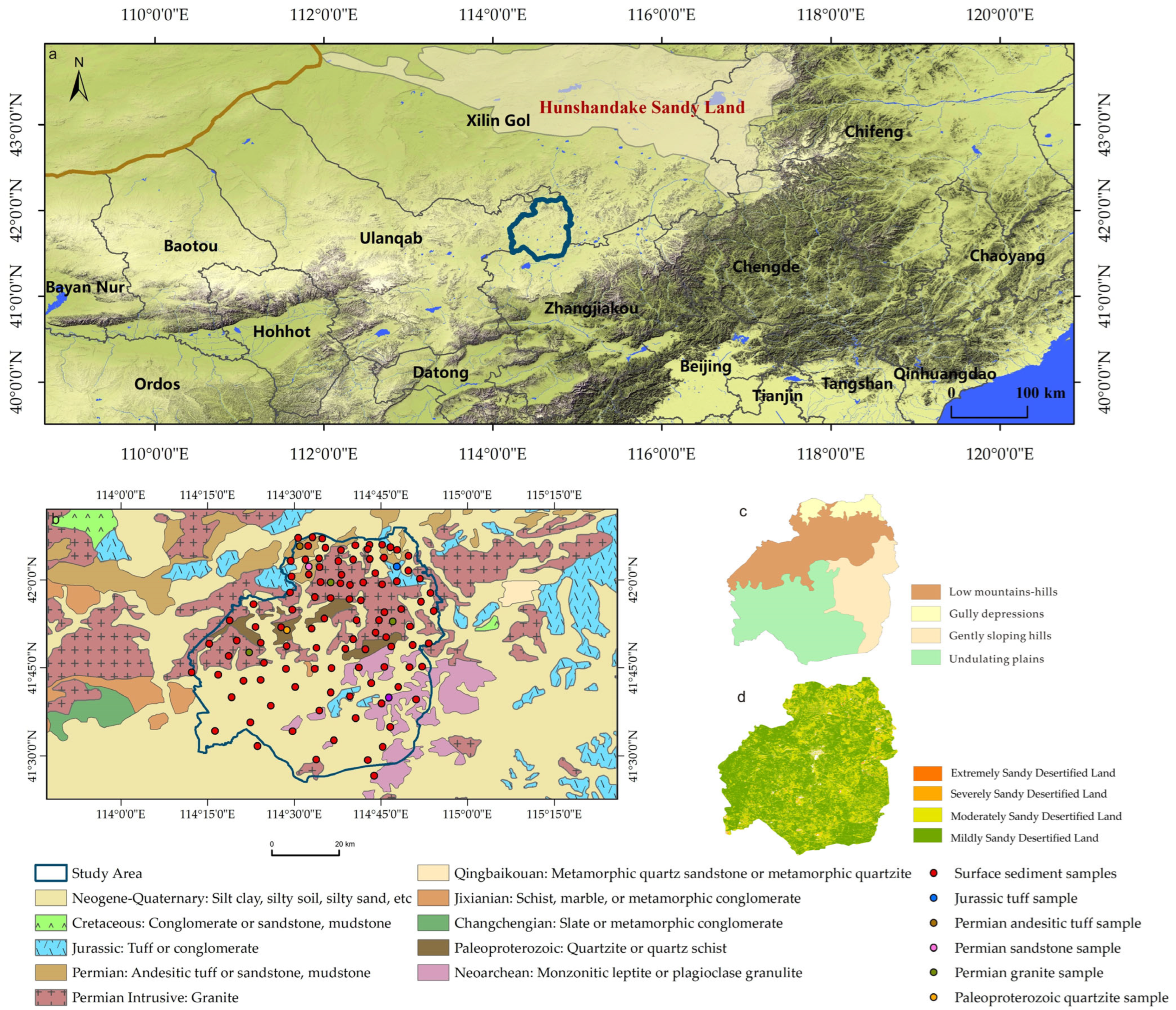
Figure 1. Location of the study area. (a) Simplified geographic elements map; (b) Geological sketch map of Kangbao and surrounding areas (adapted from China 1:500,000 Geological Map); (c) Geomorphological zoning with geochemical sampling sites; (d) Land desertification status map (2021).
Applsci 15 11785 g001
Figure 2. Normalized abundance diagrams of major elements in surface sediments from different geomorphic units relative to local bedrock. (a) Sediment samples vs. granite samples; (b) Sediment samples vs. andesitic tuff sample; (c) Sediment samples vs. sandstone sample; (d) Sediment samples vs. quartzite sample; (e) Sediment samples vs. tuff sample; (f) Sediment samples vs. monzonitic leptite sample.
Applsci 15 11785 g002
Figure 3. Normalized abundance diagrams of trace elements in surface sediments from different geomorphic units relative to local bedrock. (a) Sediment samples vs. granite samples; (b) Sediment samples vs. andesitic tuff sample; (c) Sediment samples vs. sandstone sample; (d) Sediment samples vs. quartzite sample; (e) Sediment samples vs. tuff sample; (f) Sediment samples vs. monzonitic leptite sample.
Applsci 15 11785 g003
Figure 4. Chemical weathering characteristics of four geomorphic units (Ka is kaolinite; Sm is smectite; PI is plagioclase; Ep is epidote; IL is illite; Mu is muscovite; Ks is K-feldspar; The arrow indicates the continental weathering trend).
Applsci 15 11785 g004
Figure 5. Trace element ratio diagrams comparing samples from different geomorphic units with potential source materials: (a) SiO2/Al2O3 vs. Na2O/K2O; (b) Ba/Sr vs. Rb/Sr; (c) Cr/V vs. Zr/Nb; (d) Zr/Nb vs. Nd/Y.
Applsci 15 11785 g005
Figure 6. The PCA diagram comparing samples from different geomorphic units with potential source materials: (a) PC1 vs. PC2; (b) PC1 vs. PC3; (c) PC2 vs. PC3.
Applsci 15 11785 g006
Figure 8. Sediment source-to-sink transport pattern.
Applsci 15 11785 g008
Table 1. Statistical summary of major element concentrations (wt%) in surface sediments across different geomorphic units.
SiO2Al2O3Fe2O3FeOCaOMgOK2ONa2OTiO2P2O5MnO
Gully depressionsMax81.3110.142.020.623.941.002.721.920.420.070.06
Min73.318.601.320.440.830.592.431.500.310.040.04
Mean76.769.401.680.532.030.802.581.660.370.060.05
CV0.040.060.150.130.560.160.030.080.100.190.14
Low mountains-hillsMax82.2513.223.561.063.571.213.232.230.540.120.08
Min66.758.430.960.210.770.382.551.290.220.030.03
Mean74.1510.652.090.571.610.862.791.730.430.070.06
CV0.060.130.280.330.420.230.070.110.180.320.24
Gently sloping hillsMax81.4611.142.711.171.911.132.821.780.530.100.06
Min70.728.511.120.450.870.482.561.410.290.040.03
Mean76.0510.041.810.661.310.782.691.630.420.060.05
CV0.040.080.250.320.260.250.030.080.170.280.19
Undulating plainsMax78.6513.764.290.834.241.812.962.140.670.140.08
Min58.968.91.310.371.000.592.611.480.330.040.04
Mean73.1510.511.900.622.350.922.741.690.440.070.05
CV0.080.120.440.240.530.400.040.120.240.430.24
Granite samplesMax73.4615.390.462.872.400.885.004.330.380.090.06
Min69.0213.010.420.470.930.294.323.50.120.030.03
Mean71.6014.400.441.701.460.504.573.840.240.050.04
CV0.030.090.050.710.560.650.080.110.550.690.30
Monzonitic leptite sample 72.9113.880.781.421.090.264.843.880.260.060.04
Andesitic tuff sample 58.9214.374.771.394.662.611.782.350.700.140.10
Sandstone sample 72.9914.950.530.120.400.105.434.360.090.010.01
Quartzite sample 90.626.220.350.170.070.131.021.050.040.010.02
Tuff sample 70.4212.801.080.464.260.474.702.760.130.030.04
Table 2. PCA factor loadings.
PC1PC2PC3
SiO2/Al2O30.380830.04638−0.48195
Na2O/K2O0.35903−0.197570.54569
K2O/Al2O30.212920.585720.01236
Na2O/Al2O30.421460.331150.38065
Zr/Nb0.438550.00619−0.30757
Ba/Sr−0.084620.51091−0.26066
Rb/Sr−0.259420.481640.31522
Nd/Y−0.23055−0.013040.19953
Cr/V0.42796−0.113450.15226
Variance contribution rate32.0%21.4%15.5%
Disclaimer/Publisher’s Note: The statements, opinions and data contained in all publications are solely those of the individual author(s) and contributor(s) and not of MDPI and/or the editor(s). MDPI and/or the editor(s) disclaim responsibility for any injury to people or property resulting from any ideas, methods, instructions or products referred to in the content.