New Approaches to Assess Seismic Monitoring Quality in Underground Mines: Data Completeness and Source Location Accuracy
Abstract
1. Introduction
2. Methodology
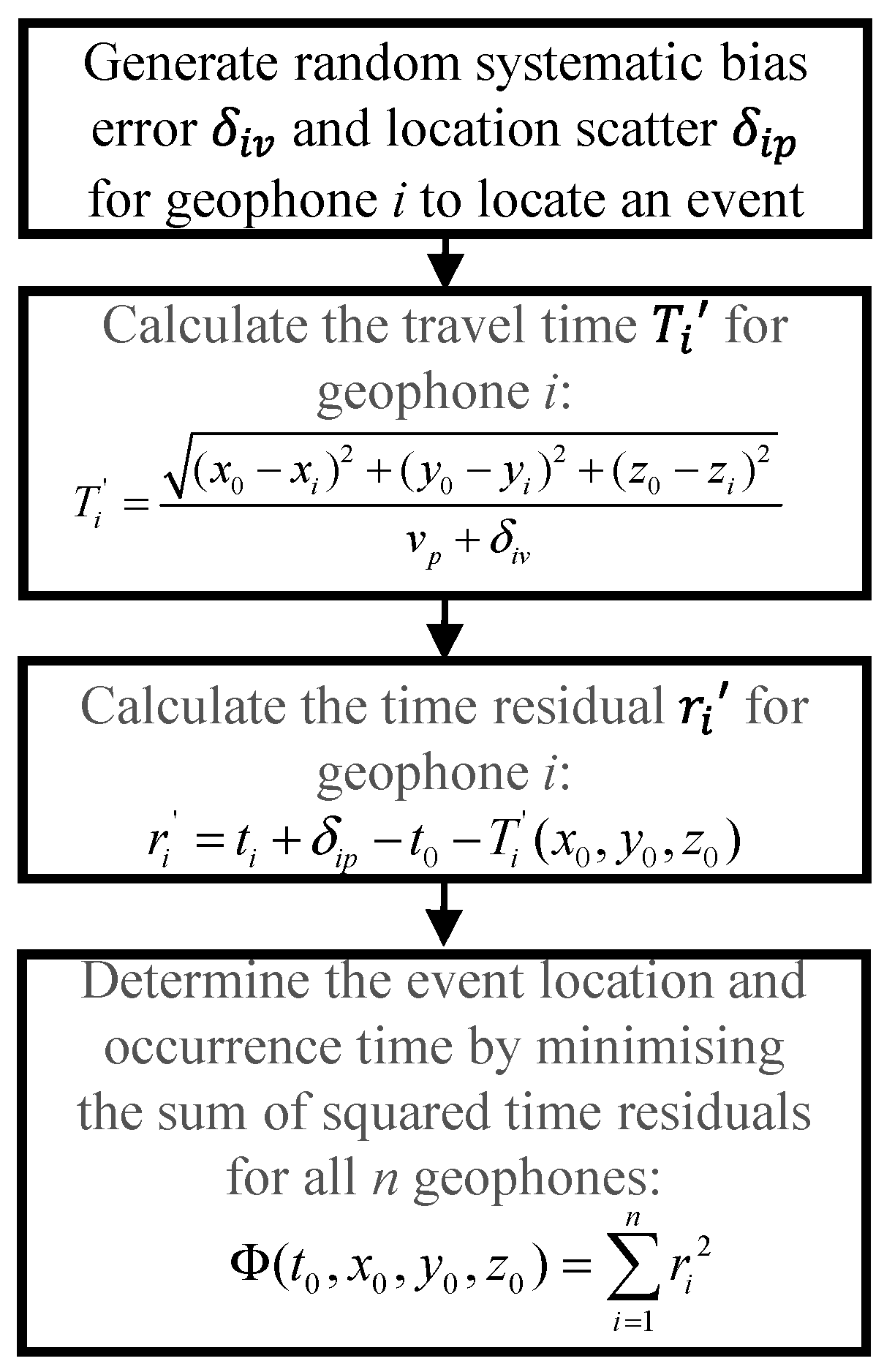
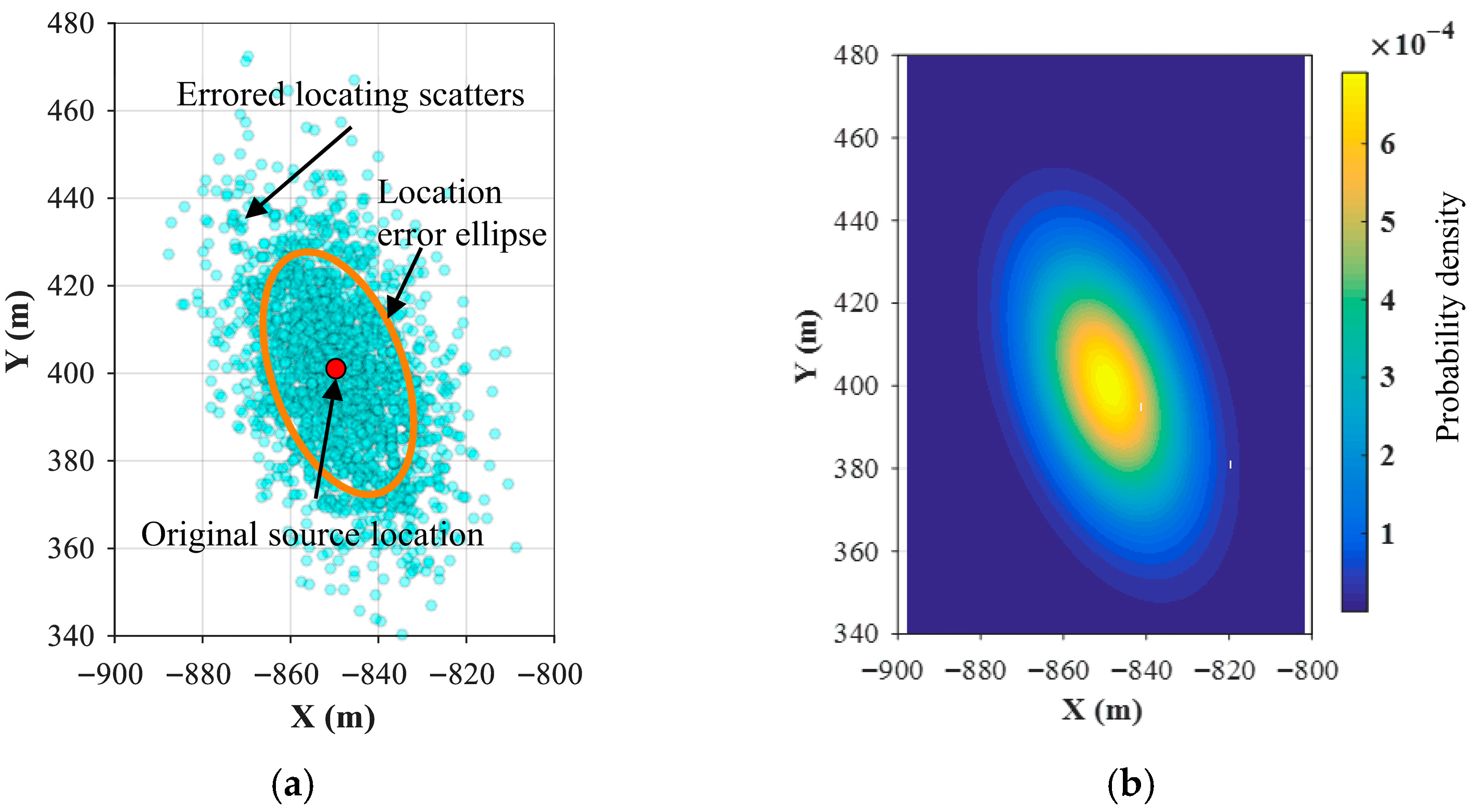
2.1. Emulation-Testing-Based Source Locating Accuracy (ETSLA) Analysis
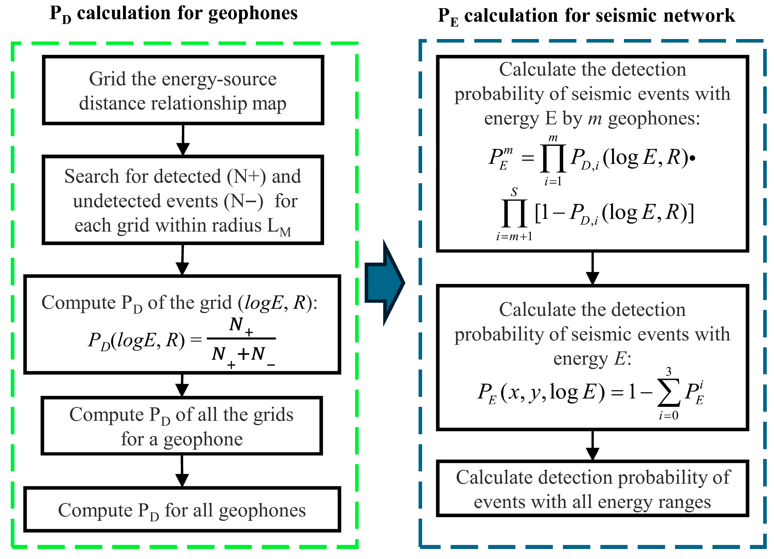
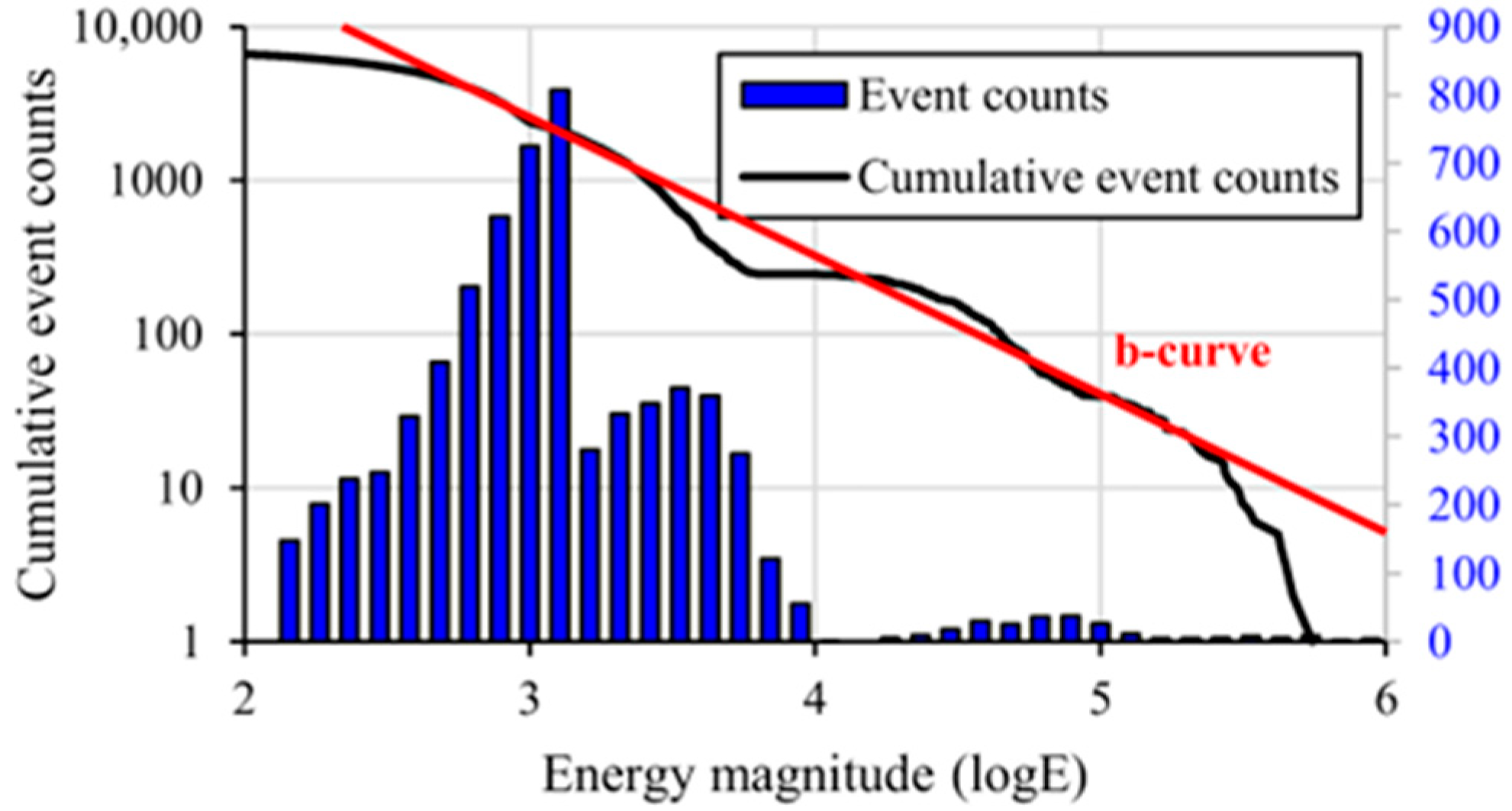
2.2. Probability-Based Magnitude of Completeness (PMC) Method
3. Site Overview
3.1. Geology and Coal Bursts
3.2. Seismic Monitoring System
4. Results
4.1. Location Errors Characteristics
4.2. Detection Probability Evaluation of Seismic Network Using the PMC Method
4.2.1. Wave Detection Capacity of Geophone ()
4.2.2. Event Detection Probability of Seismic Network ()
5. Discussion
5.1. Direct and Indirect Coal Burst Classification After Location Error Consideration
5.2. Seismic Detection Probability Availability
5.3. Coal Burst Risks Evaluation by Seismic Data Inference
5.4. ETSLA and PMC Applicability
6. Conclusions
- (1)
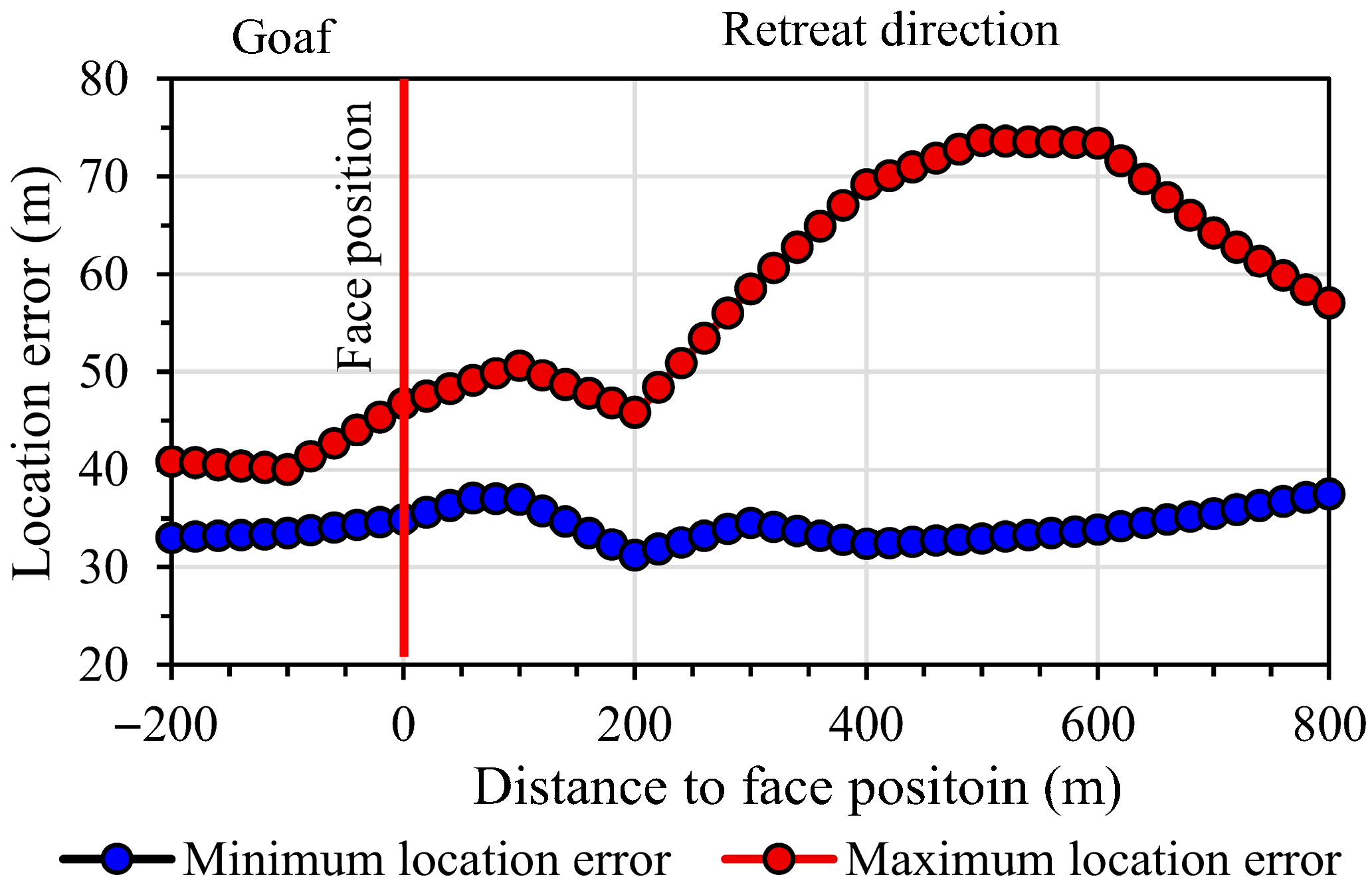
- The ETSLA method effectively quantifies the vector characteristics of source location errors, revealing anisotropic error distributions ranging from 37.7 to 105.3 m in LW401102. Optimal source-locating accuracy was observed within 200 m of the longwall face, while areas beyond 400 m exhibited extreme errors up to 105.3 m due to inadequate geophone coverage. The error ellipse model provides critical spatial references for network optimisation and burst risk assessment.
- (2)
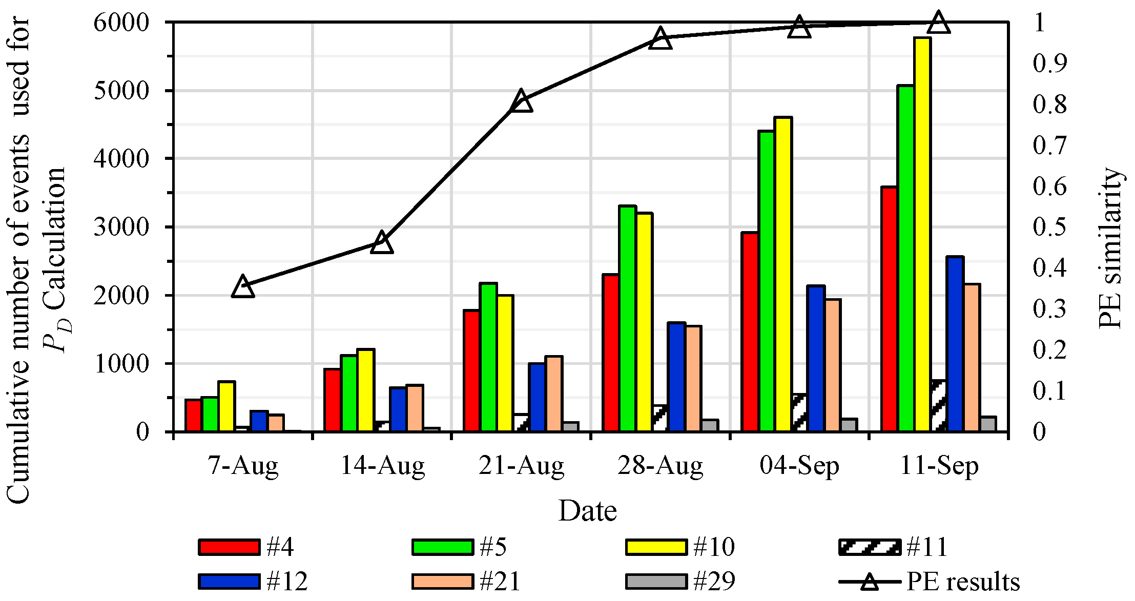
- The PMC method reveals significant differences among geophones regarding their wave detection capacities. Geophones #4, #5, and #10 exhibited superior wave detection capabilities, achieving probabilities between 0.7 and 0.9 for seismic waves from events with logE ≥ 2 within 1500 m, while geophones #11 and #29 exhibited <0.2 probability due to signal attenuation and mining noise interference.
- (3)
- Significant variations are presented in seismic event detection probability across energy levels in LW401102. The detection probability demonstrates progressive enhancement with increasing energy magnitude, rising from 0.1–0.2 at logE = 3 to 0.7 at logE = 6, though spatial coverage remains non-uniform. The limited geophone distribution primarily constrains overall seismic monitoring performance, highlighting the importance of geophone quantity and spatial arrangement for seismic networks.
- (4)
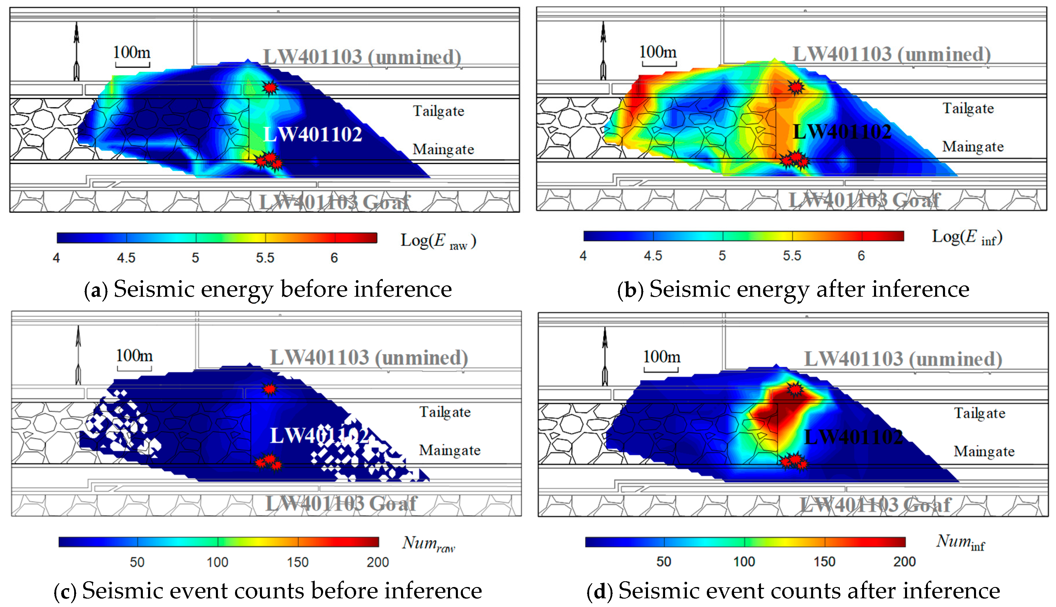
- ETSLA can correct misclassified burst types by accounting for location errors, such as reclassifying a coal burst from an indirect type to a direct one after error margin consideration. Seismic data in LW401102, inferred using the PMC method, increased event counts by 391% and energy estimates by 365%, accurately correlating inferred high-energy zones with actual burst damage locations.
- (5)
- ETSLA and PMC methods provide actionable insights for seismic network redesign, emphasising denser geophone deployment in low-probability zones, prioritised coverage of key production areas, and dynamic adjustment of monitoring parameters based on anisotropic error characteristics.
Author Contributions
Funding
Institutional Review Board Statement
Informed Consent Statement
Data Availability Statement
Conflicts of Interest
References
- Zhang, C.; Canbulat, I.; Hebblewhite, B.; Ward, C.R. Assessing coal burst phenomena in mining and insights into directions for future research. Int. J. Coal Geol. 2017, 179, 28–44. [Google Scholar] [CrossRef]
- Hebblewhite, B.; Galvin, J. A review of the geomechanics aspects of a double fatality coal burst at Austar Colliery in NSW, Australia in April 2014. Int. J. Coal Sci. Technol. 2017, 27, 3–7. [Google Scholar] [CrossRef]
- Iannacchione, A.T.; Tadolini, S.C. Occurrence, predication, and control of coal burst events in the US. Int. J. Coal Sci. Technol. 2016, 26, 39–46. [Google Scholar]
- Patyńska, R.; Mirek, A.; Burtan, Z.; Pilecka, E. Rockburst of parameters causing mining disasters in Mines of Upper Silesian Coal Basin. E3S Web Conf. 2018, 36, 03005. [Google Scholar] [CrossRef]
- Jiang, Y.; Pan, Y.; Jiang, F.; Dou, L.; Ju, Y. State of the art review on mechanism and prevention of coal bumps in China. J. China Coal Soc. 2014, 39, 205–213. (In Chinese) [Google Scholar]
- Wesseloo, J.; Woodward, K.R.; Pereira, J. Grid-based analysis of seismic data. J. South. Afr. Inst. Min. Metall. 2014, 114, 815–822. [Google Scholar]
- Wang, X. Numerical Modeling of Seismic Wave Propagation in Underground Mines. Ph.D. Thesis, Laurentian University of Sudbury, Sudbury, ON, Canada, 2015. [Google Scholar]
- Ma, J.; Dong, L.; Zhao, G.; Li, X. Focal mechanism of mining-induced seismicity in fault zones: A case study of yongshaba mine in China. Rock Mech. Rock Eng. 2019, 52, 3341–3352. [Google Scholar] [CrossRef]
- Mendecki, M.J.; Wojtecki, Ł.; Zuberek, W.M. Case studies of seismic energy release ahead of underground coal mining before strong tremors. Pure Appl. Geophys. 2019, 176, 3487–3508. [Google Scholar] [CrossRef]
- Gibowicz, S.J.; Kijko, A. An Introduction to Mining Seismology; Polish Academy of Sciences: Warsaw, Poland, 1994. [Google Scholar]
- Stec, K. Characteristics of seismic activity of the Upper Silesian Coal Basin in Poland. Geophys. J. Int. 2007, 168, 757–768. [Google Scholar] [CrossRef]
- Kijko, A.; Sciocatti, M. Optimal spatial distribution of seismic stations in mines. Int. J. Rock Mech. Min. Sci. Geomech. Abstr. 1995, 32, 607–615. [Google Scholar] [CrossRef]
- Wang, C.; Si, G.; Zhang, C.; Cao, A.; Canbulat, I. A Statistical Method to Assess the Data Integrity and Reliability of Seismic Monitoring Systems in Underground Mines. Rock Mech. Rock Eng. 2021, 54, 5885–5901. [Google Scholar] [CrossRef]
- Gong, S.; Dou, L.; Cao, A.; He, H.; Du, T.; Jiang, H. Study on optimal configuration of seismological observation network for coal mine. Chin. J. Geophys. 2010, 53, 457–465. (In Chinese) [Google Scholar]
- Cong, S. Microseismic Source Location Method Research Based on Ground-Underground Layout in Coal Mine. PhD Thesis, Xi’an University of Science and Technology, Xi’an, China, 2019. Available online: https://kns.cnki.net/kcms2/article/abstract?v=o8vMLOX1CKvSXp1nGRJKciUMm8VdGDzJYtzLn9T3Ldk7AnMiLXtmkX6zE621LE6-GTUmtpShUTNapmnJ8-CpEjK3vkHO67HqWbxXc_15_pXlURAopcUPJb4VqdigZH0iSlNSDqQfQiFwqhDjKqIWgqEk8q-fhAKVzZDPQGZjkBNfD4wCtFUEfDXz6KJRPNka&uniplatform=NZKPT&language=CHS (accessed on 16 December 2020).
- Leśniak, A. Seismic network configuration by reduction of seismic source location errors. Int. J. Rock Mech. Min. Sci. 2015, 80, 118–128. [Google Scholar] [CrossRef]
- Gao, Y.-T.; Wu, Q.-L.; Wu, S.-C.; Ji, M.-W.; Cheng, A.-P.; Yang, K. Optimization of microseismic monitoring networks based on the theory of D-optimal design. J. Univ. Sci. Technol. Beijing 2013, 35, 1538–1545. [Google Scholar]
- Gibowicz, S.J.; Lasocki, S. Seismicity induced by mining: Ten years later. Adv. Geophys. 2001, 44, 39–181. [Google Scholar]
- Woessner, J.; Wiemer, S. Assessing the quality of earthquake catalogues: Estimating the magnitude of completeness and its uncertainty. Bull. Seismol. Soc. Am. 2005, 95, 684–698. [Google Scholar] [CrossRef]
- Zúñiga, F.R.; Wyss, M. Inadvertent changes in magnitude reported in earthquake catalogs: Their evaluation through b-value estimates. Bull. Seismol. Soc. Am. 1995, 85, 1858–1866. [Google Scholar] [CrossRef]
- Mignan, A.; Werner, M.; Wiemer, S.; Chen, C.; Wu, Y. Bayesian estimation of the spatially varying completeness magnitude of earthquake catalogs. Bull. Seismol. Soc. Am. 2011, 101, 1371–1385. [Google Scholar] [CrossRef]
- Godano, C. A new method for the estimation of the completeness magnitude. Phys. Earth Planet. Inter. 2017, 263, 7–11. [Google Scholar] [CrossRef]
- Wesseloo, J. Evaluation of the spatial variation of b-value. J. South. Afr. Inst. Min. Metall. 2014, 114, 823–828. [Google Scholar]
- D’Alessandro, A.; Luzio, D.; D’Anna, G.; Mangano, G. Seismic network evaluation through simulation: An application to the Italian National Seismic Network. Bull. Seismol. Soc. Am. 2011, 101, 1213–1232. [Google Scholar] [CrossRef]
- Cao, A.; Gao, S.S. Temporal variation of seismic b-values beneath northeastern Japan island arc. Geophys. Res. Lett. 2002, 29, 41–43. [Google Scholar] [CrossRef]
- Schorlemmer, D.; Woessner, J. Probability of detecting an earthquake. Bull. Seismol. Soc. Am. 2008, 98, 2103–2117. [Google Scholar] [CrossRef]
- Mason, I. Algebraic reconstruction of a two-dimensional velocity inhomogeneity in the High Hazles seam of Thoresby colliery. Geophysics 1981, 46, 298–308. [Google Scholar] [CrossRef]
- Dubiński, J.; Lurka, A.; Mutke, G. Seismic hazard assessment using bendray and rectilinear passive tomography in the Polkowice-Sieroszowice copper mine. In Proceedings of the 8th International Symposium on Rockburst and Seismicity in Mines, Saint-Petersburg, Russia, 1–7 September 2013; pp. 1–7. [Google Scholar]
- Goszcz, A. Tectonophysical origin of mining tremors. Publ. Inst. Geophys. Pol. Acad. Sci. 1986, M-8, 61–75. [Google Scholar]
- Ortlepp, W.; Stacey, T. Rockburst mechanisms in tunnels and shafts. Tunn. Undergr. Space Technol. 1994, 9, 59–65. [Google Scholar] [CrossRef]
- Ortlepp, W. RaSiM comes of age—A review of the contribution to the understanding and control of mine rockbursts. In Proceedings of the 6th International Symposium on Rockburst and Seismicity in Mines, Perth, Australia, 9–11 March 2005; pp. 3–20. [Google Scholar]
- Kaiser, P.K.; Cai, M. Critical review of design principles for rock support in burst-prone ground–time to rethink! In Proceedings of the 7th International Symposium on Ground Support in Mining and Underground Construction, Perth, Australia, 13–15 May 2013; pp. 3–37. [Google Scholar]
- Ryder, J.A.; Jager, A.J. A Textbook on Rock Mechanics for Tabular Hard Rock Mines; The Safety in Mines Research Advisory Committee: Johannesburg, South Africa, 2002; p. 232.





| No. | Date | Event Magnitude | Source Radius (m) | Distance of the Recorded Burst Event to the Damage Zone (m) | Location Error of the Area Where the Burst Event Occurs (m) | Possible Minimum Distance of Burst Event to Damage Roadway If Location Error Considered (m) | Burst Type |
|---|---|---|---|---|---|---|---|
| 1 | 18 September 2022 | 0.18 | 6.18 | 4.4 | 34.8~46.7 37.2 | 0 | Direct |
| 2 | 22 September 2022 | 0.23 | 6.49 | 125 | 35.0~43.5 36.3 | 75.01 | Indirect |
| 3 | 24 September 2022 | 0.49 | 8.83 | 26.4 | 35.4~49.5 31.8 | 0 | Direct |
| 4 | 29 September 2022 | 0.45 | 8.40 | 266 | 37.9~46.8 40.15 | 210.8 | Indirect |
Disclaimer/Publisher’s Note: The statements, opinions and data contained in all publications are solely those of the individual author(s) and contributor(s) and not of MDPI and/or the editor(s). MDPI and/or the editor(s) disclaim responsibility for any injury to people or property resulting from any ideas, methods, instructions or products referred to in the content. |
© 2025 by the authors. Licensee MDPI, Basel, Switzerland. This article is an open access article distributed under the terms and conditions of the Creative Commons Attribution (CC BY) license (https://creativecommons.org/licenses/by/4.0/).
Share and Cite
Wang, C.; Cao, A.; Jia, B.; Li, H.; Yue, Y. New Approaches to Assess Seismic Monitoring Quality in Underground Mines: Data Completeness and Source Location Accuracy. Appl. Sci. 2025, 15, 11559. https://doi.org/10.3390/app152111559
Wang C, Cao A, Jia B, Li H, Yue Y. New Approaches to Assess Seismic Monitoring Quality in Underground Mines: Data Completeness and Source Location Accuracy. Applied Sciences. 2025; 15(21):11559. https://doi.org/10.3390/app152111559
Chicago/Turabian StyleWang, Changbin, Anye Cao, Boxun Jia, Hui Li, and Yang Yue. 2025. "New Approaches to Assess Seismic Monitoring Quality in Underground Mines: Data Completeness and Source Location Accuracy" Applied Sciences 15, no. 21: 11559. https://doi.org/10.3390/app152111559
APA StyleWang, C., Cao, A., Jia, B., Li, H., & Yue, Y. (2025). New Approaches to Assess Seismic Monitoring Quality in Underground Mines: Data Completeness and Source Location Accuracy. Applied Sciences, 15(21), 11559. https://doi.org/10.3390/app152111559


